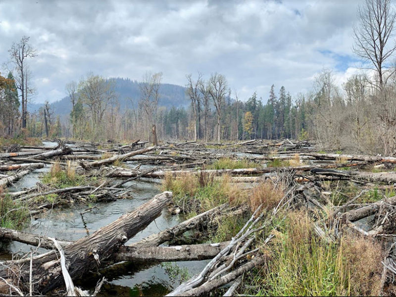
The restored floodplain of the South Fork McKenzie River in Oregon, USA after the 2020 Holiday Farm Fire. Credit: Kate Meyer, USDA Forest Service
Here’s the release from the American Geophysical Union (Ellen Wohl):
Floodplains store materials moving downstream and, in doing so, provide habitat for a wide variety organisms. Water, dissolved materials, sediment, and organic matter move downstream, but individual water or solute molecules or sediment grains can be stored on floodplains for periods that range from a few minutes to 10,000 years for sediment on the floodplain of the Amazon River. Storage reflects the strongly three-dimensional movements of materials in a river corridor. Episodic exchanges of water, solutes, sediment, and organic matter between the channel, floodplain, and subsurface create a dynamic environment with diverse habitat. A recent article in Reviews of Geophysics examines the influencing factors and nature of floodplain storage. Here, the author answers our questions about floodplain storage.
What different materials move around and are stored on floodplains?
The main categories of material moving within and stored on floodplains are water, solutes, sediment, and organic matter.
Storage of water on floodplains is critical during the extremes of weather: overflow of high water onto a floodplain can reduce the peak flow and limit flood damage, and storage of water in the subsurface of a floodplain can sustain base flow during dry periods.
Among solutes, nutrients such as nitrogen and phosphorus receive a lot of attention, partly because they represent a paradox. Although these elements are necessary to most living organisms, human activities have introduced such large amounts of nitrogen and phosphorus to rivers that the excess now creates severe environmental problems such as eutrophication, or lack of dissolved oxygen in the water that results in fish die-offs.
Contaminants such as heavy metals or synthetic chemicals that attach to silt and clay can also be stored in floodplains, limiting the concentrations of these toxins in the channel.
Burned uplands adjacent to the South Fork McKenzie floodplain after the 2020 Holiday Farm Fire. Credit: Kate Meyer, USDA Forest Service
How does the concept of a “budget” help us to understand inputs, outputs, and storage on a floodplain?
Thinking of a budget that applies over specified time and space scales can help to identify sources and processes that create inputs, outputs, and storage.
The measurements used to create a sediment budget, for example, could help to identify whether a floodplain is losing mass through time (net erosion of sediment) at a rate that might alter the ability of the floodplain to attenuate flood peaks. Or, measurements that quantify sediment inputs and outputs could identify a net gain of sediment through time as a result of upstream changes in land cover or changing climate across the watershed.
A floodplain integrates processes occurring throughout the upstream contributing area and creates a stratigraphic record of these processes. Changes in floodplain budgets over thousands of years can be interpreted from this stratigraphic record, facilitating our ability to infer the associated changes in watershed processes.
What are some of the main natural factors that affect floodplain storage?
Primary natural controls on floodplain storage are the width of the valley floor relative to the width of the channel. Many natural rivers alternate repeatedly downstream between relatively narrow and wider portions of the valley.
The heterogeneity of the floodplain surface and stratigraphy also strongly influence storage. Generally, the more heterogeneous or patchy the floodplain, the greater the storage because the irregular surface and stratigraphy effectively slow the downstream movement of water, solutes, sediment, and organic matter.
The fluxes of material moving down the channel also influence floodplain storage. Some of the sediment moving down a channel with a large sediment flux is more likely to be stored on the floodplain than in a river corridor with very little sediment moving downstream.
How do human activities affect floodplain storage?
Human activities can directly affect floodplain storage by disconnecting the channel and floodplain.
Artificial levees and flow regulation exemplify human-induced changes that typically limit overbank movement of materials from the channel to the floodplain.
People also change the character of the floodplain via land drainage and groundwater pumping that dry the floodplain and by changing the floodplain land cover through agriculture and urbanization.
Aggregate mining on floodplains not only reduces sediment storage but severely disrupts the movement and storage of other materials on floodplains.
Human activities can increase floodplain storage by introducing larger quantities of solutes or sediment to a river network. Excess nitrogen resulting from fossil-fuel combustion and agricultural fertilizers is sometimes referred to as the nitrate time bomb because, even after nitrate inputs to a river network are reduced, the excess nitrate continues to accumulate at progressively higher levels in floodplain sediments.
Overall, however, human alterations simply and homogenize floodplains and reduce floodplain storage.
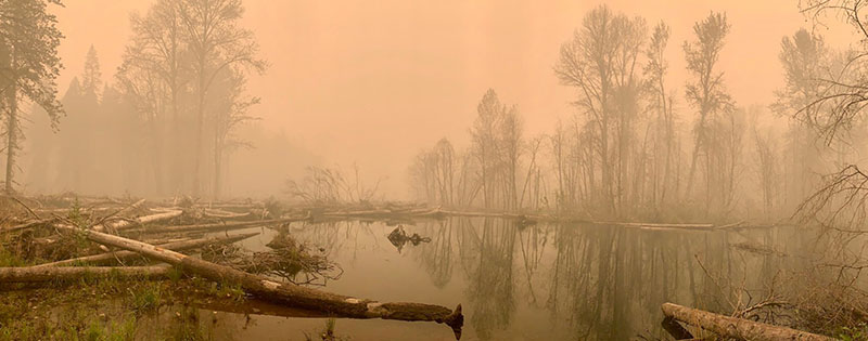
The restored floodplain of the South Fork McKenzie River during the 2020 Holiday Farm Fire. Credit: Kate Meyer, USDA Forest Service
What is “floodplain restoration” and why is it needed? Can you give a specific example of a floodplain restoration scheme that improved resilience to natural and human disturbances?
Floodplain restoration involves restoring processes that create and maintain floodplain functions, typically by restoring the three-dimensional exchanges of water, solutes, sediment, and organic matter between the channel, floodplain, and subsurface.
Floodplain restoration is needed for at least three reasons. First, floodplain storage reduces downstream hazards associated with floods and excess sediment. Second, fully functional floodplains host high levels of biodiversity and provide ecosystem functions such as clean water. Third, floodplains have not received the legal protection afforded to navigable rivers in the US and other countries.
Floodplains are likely to be in private ownership and to be heavily altered by agriculture and urbanization; consequently, they are endangered ecosystems. Ongoing river restoration at the South Fork McKenzie River in Oregon, USA has reconnected the channel and floodplain. When the Holiday Farm fire burned through the area in 2020, the presence of water on the newly reconnected floodplain decreased the burn severity in the restoration area.
What are some of the unresolved questions where additional research, data, or modeling is needed?
We have made good progress in measuring and modeling some of the processes involved in floodplain storage, especially for surface water and sediment, but there are huge discrepancies between our understanding of surface water and sediment dynamics and our understanding of subsurface water, solute, and organic matter inputs, outputs, and storage.
Because our understanding of the movements of these latter materials is limited, we cannot yet integratively model how subsurface water, solutes, microbial communities, and organic matter, for example, interact within a floodplain over diverse scales of time and space. The ability to develop this type of model would be ideal for predicting floodplain response to restoration.
In the meantime, treating floodplain restoration projects as experiments that are monitored and used to gain understanding that can inform future restoration is critical.
Screen shot from the City of Thornton Big Dry Creek Recreation & Floodplain Restoration Master Plan (Click image to read the report)
From Great Outdoors Colorado via The Northglenn/Thornton Sentinel:
Thornton’s work restoring 25 acres of the Big Dry Creek Open Space has been recognized by the Colorado Lottery.
The Colorado Lottery announced on April 21 that it had awarded the city a Starburst Award for the project, which used lottery proceeds to help pay for the work.
“Conservation is a key pillar for the Lottery. It includes not only conserving open space, but also upgrading recreational spaces, creating new places for Coloradans to play, and supporting ecosystems and wildlife,” said Tom Seaver, director of the Colorado Lottery. “This year’s Starburst Award winners aptly reflect the wide-ranging projects that our proceeds support. With now $3.6 billion going to our proceeds beneficiaries, we continue to look for new ways to grow revenue responsibly to protect more of Colorado’s great outdoors.”
The $1,745,000 project used a $75,000 planning grant and $100,000 Great Outdoors Colorado Habitat Restoration grant to the City of Thornton, both Colorado Lottery proceeds, to help pay for the work.
The city restored approximately 25 acres of Big Dry Creek Open Space, an important natural resource and ecosystem for east-west wildlife migration, as part of the project. Due to erosion and noxious weeds, Big Dry Creek’s floodplain had been severely compromised. GOCO funding was used to improve conditions along the creek and create overflow wetlands that will reduce flood hazards and protect water quality. These restoration efforts have also helped improve critical habitat for bald eagles, blacktailed prairie dogs, peregrine falcons, red foxes, and great blue herons, among other species.
The Big Dry Creek project was the last remaining open space ‘pearl’ needed to create a complete system of open space corridors in Thornton. Big Dry Creek provides outstanding opportunities for passive recreation and wildlife habitat and encompasses almost 300 acres of open space areas that have been preserved through acquisition by Thornton and Adams County.
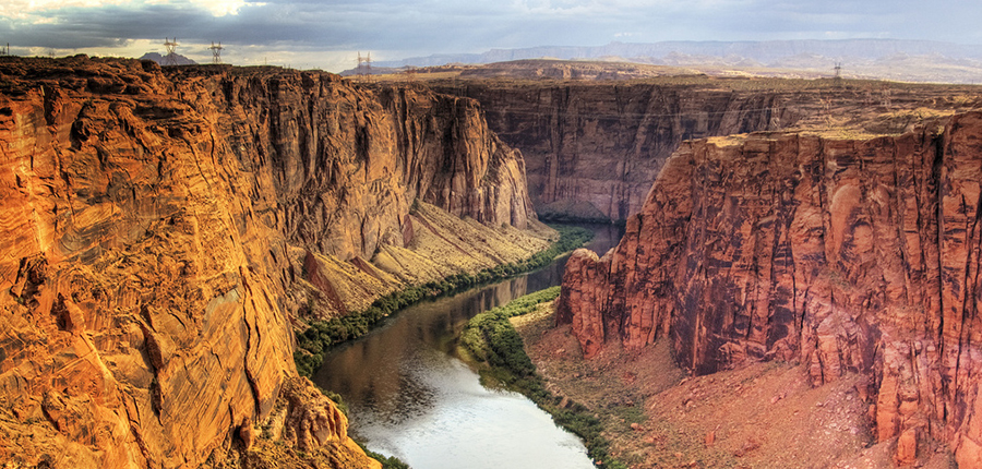
Colorado River. Photo credit: University of Montana
I heard about this at yesterday’s AWRA Colorado Section Annual Symposium. Click through for the resources.
The Colorado River provides water to more than 40 million people in two countries, seven states, and 29 Indian tribes. The demand for water currently exceeds available supply in any given year and is complicated by chronic drought and the uncertainty of impacts from climate change.
The 29 federally recognized tribes in the basin depend on the waters of the Colorado River and its tributaries for a variety of purposes, including cultural and religious activities, domestic, irrigation, commercial, municipal and industrial, power generation, recreation, instream flows, wildlife, and habitat restoration.
These tribes hold legal rights to a significant amount of water, many of which are the most senior in the basin. Combined, the tribes hold rights to roughly 20 percent (or 2.9 million-acre feet) of the water in the Colorado River basin. With the oldest water rights in the basin, the tribes are in a position to play a significant role in balancing water demand and supply and otherwise shaping the future of the region.
Since 2017, the Center has been working with the Babbitt Center for Land and Water Policy, Walton Family Foundation, Ten Tribes Partnership, and many other individuals and groups to enhance tribal capacity and advance sustainable water management in the basin through collaborative decision-making.
The Initiative is guided by a broad-based Leadership Team (see a list of members and their bios below). It is not a decision-making body; does not speak on behalf of tribes, tribal associations, or any other organization or group; and is not an advocate for any particular interest or outcome. It seeks to enhance the capacity of tribes and to advance sustainable water management through collaborative decision-making.
Leadership Team
Tribal Members
Bidtah Becker, Navajo Nation
Leland Begay, Ute Mountain Ute
Lorelei Cloud, Southern Ute Tribe
Maria Dadgar, Inter Tribal Council of Arizona (Jay Tomkus, alternate)
Jason John, Navajo Nation
Nora McDowell, Fort Mojave Indian Tribe
Margaret Vick, Colorado River Indian Tribes
Jay Weiner, Quechan Tribe
Other Members
Anne Castle, Getches-Wilkinson Center, University of Colorado
Peter Culp, Culp & Kelly (Mary Kelly, alternate)
Becky Mitchell, Colorado Water Conservation Board
Colby Pellegrino, Southern Nevada Water Authority
Jason Robison, University of Wyoming, College of Law
Tanya Trujillo, Colorado River Sustainability Initiative
Garrit Voggesser, National Wildlife Federation
John Weisheit, Living Rivers
NASA scientists used tree rings to understand past droughts and climate models incorporating soil moisture data to estimate future drought risk in the 21st century.
We’re halfway through April and the longer days are warming up the soil, so Colorado farmers and ranchers are starting to plant.
Colorado Drought Monitor April 20, 2021.
But a quick look at the drought map for Colorado shows why agriculture producers are concerned for the future of their crops. Almost 90 percent of the state is in a moderate drought.
What makes this April stand out is how much land is an extreme or exceptional drought — nearly a third of the state. In the 21-year history of the U.S. Drought Monitor, only Colorado’s 2013 drought shows more D3 and D4 conditions in April…
Les Owen, the conservation services division director with the Colorado Department of Agriculture, said the drought conditions are “extremely concerning” for farmers and ranchers.
“Last year during the critical growing times when we needed moisture, there just wasn’t much in most areas of the state,” Owen said. “So folks have already been punched in the gut pretty hard from drought.”
[…]
Owen noted that last year’s wildfires burned swaths of federal land that ranchers usually graze their cattle on.