Click on a thumbnail graphic to view a gallery of drought data from the US Drought Monitor.
US Drought Monitor March 30, 2021.
West Drought Monitor March 30, 2021.
High Plains Drought Monitor March 30, 2021.
Colorado Drought Monitor March 30, 2021.
Click here to go the US Drought Monitor website. Here’s an excerpt:
This Week’s Drought Summary
Multiple low pressure systems resulted in widespread precipitation (0.5 to 3 inches, or more) from the Mississippi Valley to the East Coast during late March. Heavy to excessive rainfall (more than 5 inches) soaked southeast Louisiana and triggered flooding across Tennessee this past week. Along with the flooding, a severe weather outbreak affected Alabama, Georgia, Tennessee, and Kentucky on March 25. Mostly dry weather persisted farther to the south, including the Florida Peninsula and south Texas. A cold front brought strong winds to the northern Plains on March 29 but little or no precipitation. Rain and high-elevation snow was limited to coastal Washington and the northern Cascades across the Pacific Northwest, while mostly dry weather prevailed throughout California. 7-day temperatures from March 23-29 averaged below (above) normal across the western (eastern) U.S…
Another dry week along with strong winds on March 29 resulted in a slight expansion of extreme drought (D3) across North Dakota and northern South Dakota. This expanding D3 area was based mostly on SPI at EDDI at various time scales. Soil moisture remains below the 5th percentile for much of North Dakota. Based on snow water content running near average and 6 to 12 month SPIs, D3 was improved by one category across north-central Wyoming. Following multiple changes during the previous two weeks across Colorado, only minor improvements were needed this week. Localized improvements were made to small areas of southern Colorado, based in part on WYTD (since Oct 1, 2020) precipitation…
Widespread extreme (D3) to exceptional (D4) drought continues to be focused across the Southwest. According to the USDA (for the week ending March 28), nearly two-thirds of the winter wheat is rated as very poor in New Mexico. As of March 27, snow water content is running near 70 percent of average for the Sierra Nevada Mountains. Due to this snow water content along with WYTD (since Oct 1, 2020) precipitation deficits, long-term drought persists for nearly all of California. Since precipitation averaged below normal during March, the impact type was adjusted to include both long and short-term drought for California, along with parts of the Southwest. Based on SPIs at various time scales, D1 (moderate drought) was slightly expanded across north-central Montana while below average snow water content prompted an increase in abnormal dryness (D0) for northwest Montana. To the west across eastern Washington, below average precipitation during March and drying topsoil prompted an expansion of D0 and D1 (short-term moderate drought)…
On March 23 and 24, heavy rainfall (more than 5 inches) resulted in a 2-category improvement to southeast Louisiana where soil moisture is currently above the 70th percentile. However, much less rain fell across northern Louisiana where an expansion of D0 (abnormal dryness) and D1 (moderate drought) was made. The recent heavy rainfall also led to elimination of abnormal dryness (D0) across the Mississippi Gulf Coast. Heavy rainfall triggered flooding across much of Tennessee during late March and the small areas of D0 were removed from the state. Additional improvements from the previous two weeks continued across the Texas Panhandle, while mostly dry weather and increasing precipitation deficits along with worsening soil moisture conditions resulted in expansion of D1 (short-term moderate drought) across parts of southeast Texas. Soil moisture rapidly declines from east to west across Texas…
Looking Ahead
During the next 5 days (April 1 to 5), much drier weather is forecast for the eastern and central U.S. in the wake of a cold front. Mostly dry weather is also expected for the western U.S. with light precipitation limited to the Pacific Northwest and northern California. A brief period of below normal temperatures are forecast for the eastern U.S. and Gulf Coast States. A freeze may affect areas as far south as the Tennessee Valley and southern Appalachians from April 1 to 3. Meanwhile, a rapid warming trend is likely over the northern and central Great Plains with much above normal temperatures forecast during the first week of April.
The CPC 6-10 day extended range outlook (valid from April 6 to 10) favors above normal temperatures across the central and eastern U.S. with the largest probabilities centered over the central and southern Great Plains. Below normal temperatures are most likely along the West Coast and throughout Alaska. Probabilities of below normal precipitation are elevated from the Southeast westward to the southern Great Plains and southern Rockies. Near to above normal precipitation is favored for the Corn Belt, northern Great Plains, much of the western U.S., and Alaska.
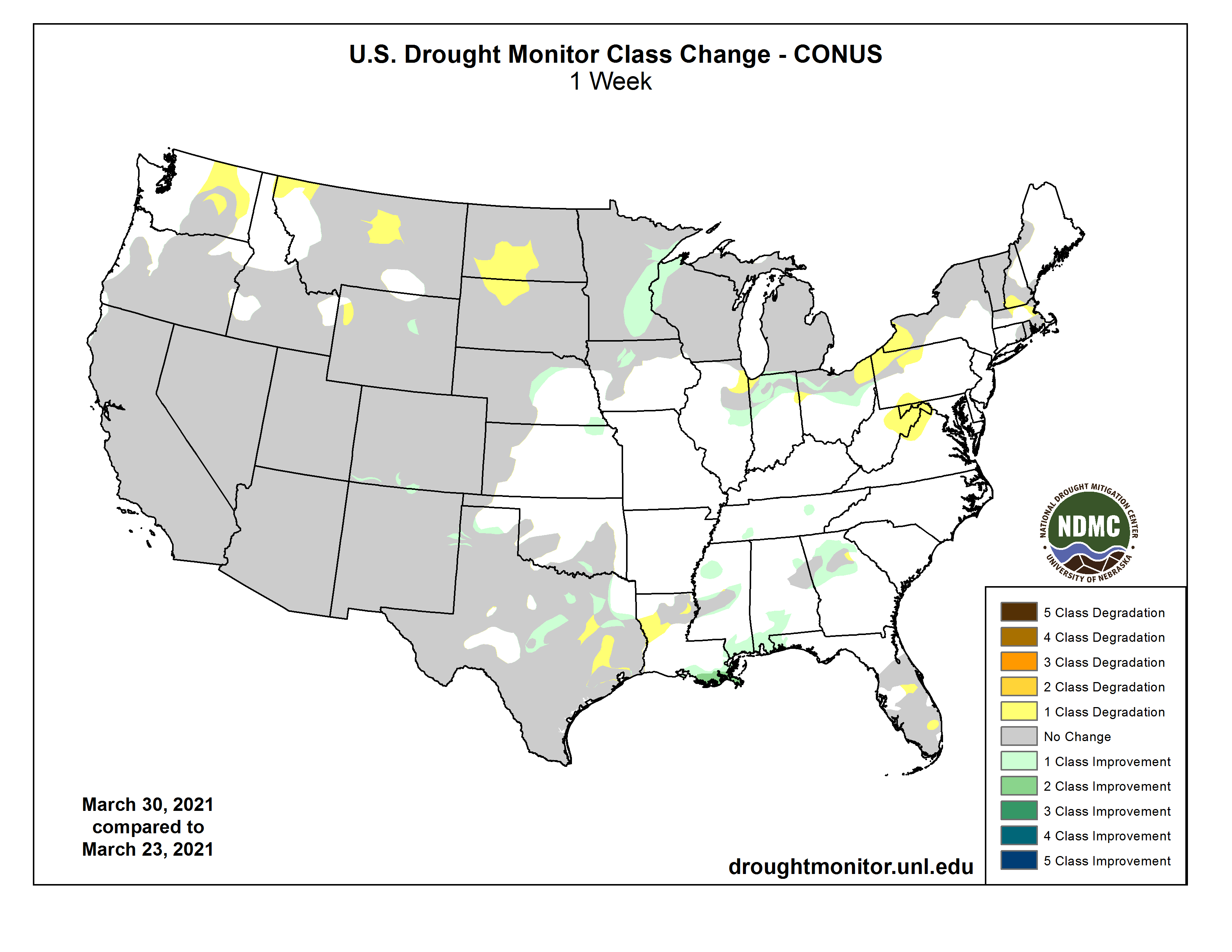
US Drought Monitor one week change map ending March 30, 2021.
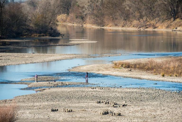
The American River in Sacramento in 2014 shows the effects of the 2012-2016 drought. Climate change is expected to result in more frequent and intense droughts and floods. (Source: California Department of Water Resources)
From The Water Education Foundation (Gary Pitzer):
WESTERN WATER NOTEBOOK: STATE WATER BOARD REPORT RECOMMENDS ALIGNING NEW WATER RIGHTS TO AN UPENDED HYDROLOGY
As California’s seasons become warmer and drier, state officials are pondering whether the water rights permitting system needs revising to better reflect the reality of climate change’s effect on the timing and volume of the state’s water supply.
A report by the State Water Resources Control Board recommends that new water rights permits be tailored to California’s increasingly volatile hydrology and be adaptable enough to ensure water exists to meet an applicant’s demand. And it warns that the increasingly whiplash nature of California’s changing climate could require existing rights holders to curtail diversions more often and in more watersheds — or open opportunities to grab more water in climate-induced floods.
“California’s climate is changing rapidly, and historic data are no longer a reliable guide to future conditions,” according to the report, Recommendations for an Effective Water Rights Response to Climate Change. “The uncertainty lies only in the magnitude of warming, but not in whether warming will occur.”
The report says climate change will bring increased frequency and intensity of extreme weather events, such as atmospheric rivers and drought, prolonged fire seasons with larger fires, heat waves, floods, rising sea level and storm surges. Already, the state is experiencing a second consecutive dry year, prompting worries about drought. “The wet season will bring wetter conditions during a shorter period, whereas the dry season will become longer and drier,” the report said.
The State Water Board report catalogues 12 recommendations — inserting climate-change data into new permits, expanding the stream-gauge network to improve data and refining the means to manage existing water rights to ensure sufficient water is available to meet existing demands. At the same time, the report says, the State Water Board should build on its existing efforts to allow diverters to capture climate-driven flood flows for underground storage.
Because floods and the magnitude of the peak flows are expected to increase under many climate change projections, “there may be greater opportunity to divert flood and high flows during the winter to underground storage,” the report said. The State Water Board could build on the flood planning data used by the Department of Water Resources to help inform water availability analyses and to spell out conditions for the resulting water right permits for floodwater capture.
“The recommendations are a menu of options,” said Jelena Hartman, senior environmental scientist with the State Water Board and chief author of the report. The goal, she said, was to “clearly communicate what the water rights issues are and what we can do.”
The result of a 2017 State Water Board resolution detailing its comprehensive response to climate change, the report could be the first step toward a retooled permitting system for new water rights applications. (The Board has averaged about a dozen newly issued permits per year, mostly for small diverters, since 2010.) The State Water Board is seeking public comments on the report through March 31.
And while the report does not call for reopening existing permits, it does sound a warning for those permit holders: With droughts projected to become longer and more severe, the State Water Board may need to curtail water diversions more often and in more watersheds.
Time to ‘Reset Expectations’?
During a March 18 webinar on the report, Erik Ekdahl, the State Water Board’s deputy director for the Division of Water Rights, said it may be time to “reset expectations” regarding curtailments for water use permits, given that curtailments have only been implemented by the state in 1976-1977 and 2014-2015.
“That’s not an overuse of curtailments,” he said. “If anything, it’s an underuse. We may need to look at curtailment more frequently.”
Climate change is expected to move the snow line in Sierra Nevada watersheds higher, which will likely change the timing and volume of winter and spring runoff. (Source: California Department of Water Resources)
Some water users fear the report could be the beginning of a move to restrict their access.
“To the extent climate change is incorporated into water rights administration, it should be to respond to a changing hydrology in a manner that is protective of existing users … and not to turn back the clock on water rights or to service new ambitions for instream flows that aren’t in the law,” said Chris Scheuring, senior counsel with the California Farm Bureau Federation.
The report notes that many of California’s existing water rights are based on stream gauge data drawn during a relatively wet period (since about 1955). Although California has had some of its most severe droughts on record since the 1970s, annual flow on many streams is highly variable due to California’s Mediterranean climate. Fluctuations in year-to-year precipitation are greater than any state in the nation, ranging from as little as 50 percent to more than 200 percent of long-term averages.
Joaquin Esquivel, chair of the State Water Resources Control Board. (Source: State Water Resources Control Board)
If climate conditions swing drier overall, the report says, it will be difficult for those existing water right holders to divert their permitted volume. Expanding the network of stream and precipitation gauges will be critical, the report says, to improving the accuracy of water availability analyses.
But the report’s focus is on new water rights applicants and the need to weave climate change data into their permits to provide a clear description of projected water availability. “We take the long view in asking if there is sufficient water available for a new appropriation,” Hartman said.
State Water Board leaders said the water rights response is part of the umbrella of actions needed to confront climate change.
“Water rights can either be something that helps us adapt and create resiliency … or it can really hinder us,” Chair Joaquin Esquivel said at the Board’s Feb. 16 meeting where the report was presented.
Writing Climate Change into New Permits
The fingerprints of climate change are increasingly evident in California’s seasonal weather. Extreme conditions are on the upswing. Peak runoff, which fuels the state’s water supply, has shifted a month earlier during the 20th century. The four years between 2014 and 2017 were especially warm, with 2014 the warmest on record. Annual average temperatures in California are projected to rise significantly by the end of the century.
“We are already experiencing the impacts of climate change,” said Amanda Montgomery, environmental program manager with the State Water Board. The continuous warming creates an “unambiguous trend” toward less snow, she said, and shifts in snowpack and runoff are relevant for water management and water rights.
Jennifer Harder, a professor at McGeorge School of Law in Sacramento and an expert on water rights law. (Source: McGeorge School of Law)
Jennifer Harder, a water rights expert who teaches at the University of Pacific’s McGeorge School of Law in Sacramento, said integrating climate change considerations into water rights permits is good policy that aligns with the State Water Board’s mission of ensuring the highest and most beneficial use of water.
“It’s beyond dispute that the changes in precipitation and temperature patterns resulting from climate change will affect water availability,” she said.
Kimberly Burr, a Sonoma County environmental attorney and member of the North Coast Stream Flow Coalition, told the State Water Board at the Feb. 16 meeting that knowledge about the effects of climate change on water is sufficient enough to be incorporated into new water rights permits. It’s an important issue, she said, because the state must ensure adequate flows exist to protect endangered species, vulnerable communities and public needs under the public trust doctrine.
“There is a finite amount of water and we have to prepare for the worst and move forward with great caution,” she said.
A Challenging Water Rights System
Water rights in California are based on a permitting system that includes several specifics, such as season and point of diversion and who can continue taking water when there is not enough to supply all needs. Getting a water right permit can take from several months for a temporary permit to several years for a permanent right.
In deciding whether to issue permits, the State Water Board considers the features and needs of the proposed project, all existing and pending rights, and the necessary instream flows to meet water quality standards and protect fish and wildlife.
The priority of a water right is particularly important during a drought, when some water right holders may be required to stop diverting water according to the priority of their water right. Suspension of right is done through curtailments of the user’s ability to divert water.
Dorene D’Adamo, a member of the State Water Resources Control Board. (Source: State Water Resources Control Board)
If the State Water Board implemented the recommendations in the water rights and climate change report, critics say, it would add another component in a system that aims to meet the demand for additional water. Already, local groundwater agencies are lining up to get access to available water sources for aquifer recharge and groundwater banking so they can comply with the state’s Sustainable Groundwater Management Act.
Some question whether putting the report’s recommendations into action would possibly hinder the permitting process.
“The concern I have is we have quite a big backlog already and it’s already challenging to get through the system,” said State Water Board Vice Chair Dorene D’Adamo, who serves as its agriculture member. “How do we incorporate all of this and still be nimble and move with deliberate speed?”
Incorporating a climate change response into new water rights permits would be complicated, but necessary, State Water Board member Tam Doduc said.
Striving For Complete Data
Adding climate change data to water rights permits applications is problematic because of questions about the precision of existing data and the degree to which it can be localized.
A State Water Board report on adapting water rights permits to address climate change impacts says the state needs to improve its system of stream and precipitation gauges to better track climate change impacts on water availability. (Source: California Department of Water Resources)
“Current climate change models have disparate findings, and many are calibrated for a global scale but not regional areas,” Lauren Bernadett, regulatory advocate with the Association of California Water Agencies, told the Board. “The recommendations insert significant uncertainty for any person or agency applying for a permit.”
Harder, the law professor, said good data is critical for determining water availability, but perfect data to achieve absolute certainty is unattainable. “There are many different facets of water management and it requires us to give careful thought into how we make decisions in the face of the data we have, knowing it will never be perfect and always be changing” she said.
Better streamflow data is crucial to knowing whether the water exists to support new permits. The report notes that the low number of gauges, particularly on the smaller stream systems in California, means there is often not enough information to accurately characterize hydrologic variability over years or decades. That significantly limits the ability to reliably estimate water availability.
The report says the state may need to rethink how it estimates water availability. It added that one way to improve accuracy may be temporary installation of portable stream gauges at requested diversion points.
Moving From Theoretical To Practical
Addressing how to respond to climate change in water rights permitting would be a substantial undertaking, particularly given the existing array of complex and controversial matters on the State Water Board’s agenda.
“We don’t have all the details yet and this won’t be an easy task,” Doduc said. “Too often we focus on our water quality activities because water rights are too difficult.”
Said Esquivel: “There is a lot of work to be done and it can seem overwhelming. But there is a lot of great groundwork and a commitment to making sure the water rights system is going to adapt and be here for us when we need it most.”
The State Water Board already has broad authority under existing law to take on climate change in water rights permits should it decide to do so, said Harder, with McGeorge Law School.
“What the board is trying to do,” she said, “is snap those tools together in a new way and polish up the edges.”
However the issue proceeds, Harder said, the state should recognize that water resources are best understood by the local agencies that have the most pertinent information about them.
“We need to approach this as a partnership as opposed to looking at it through the lens of … state power vs. local power,” she said. “There is an important role for both here.”
Reach Gary Pitzer: gpitzer@watereducation.org, Twitter: @GaryPitzer.
As Earth heats up thanks to human-caused climate change, scientists expect that winter snowpacks will melt increasingly earlier in the spring. According to a new NOAA-funded study, these impacts are already underway, but global warming isn’t impacting every region equally. While snowpack in some regions has been relatively unaffected, snowpack in other regions is melting nearly a month earlier than usual.
Based on observed snowpack and temperature data from 1982-2018, this map shows how one degree Celsius of warming advances snowpack disappearance date—the number of days earlier in the spring when all the winter snow has melted. Darker shades of gray and pink show more vulnerable regions, where one degree of warming is causing snowpack to disappear as much as 27 days earlier.
According to model results, overall, coastal (low elevation) and southern regions are more vulnerable than northern interior regions. In the United States, the snowpack disappearance dates in southern Alaska, the Cascades, Sierra Nevadas, across the lower Midwest, and along parts of the Appalachians are changing more rapidly than in regions like the Rocky Mountains and Upper Midwest. Globally, parts of the coastal Arctic, the European Alps, and lower regions of the Himalayas have been more affected, while snowpack in the northern interiors of Europe and Asia, including the central region of Russia, is disappearing just 3 days earlier.
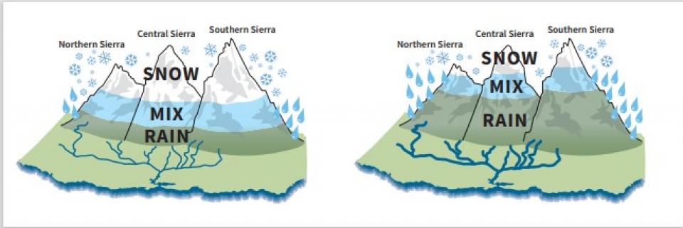
To understand the differences, we need to look at how temperature changes throughout the year. Snowpack in regions with smaller swings in temperature between winter and summer is more vulnerable to warming than snowpack in regions with greater seasonal temperature differences. In coastal regions, for instance, the ocean acts as a big thermal regulator, making winters warmer, keeping summers cooler, and reducing the annual temperature range. The ocean’s influence means fewer days with wintertime temperatures at or below freezing (32°F or 0°C) for snow to fall and accumulate, compared to inland areas at the same latitude.
So in coastal regions like the Cascades, just one degree of warming can cause a dramatic reduction in the number of days below freezing and bring a much earlier start to spring and snowmelt. However, northern interior regions see bigger temperature swings between winter and summer, with more days annually at or below freezing for snowfall. In these regions, one degree of warming causes a smaller decrease in below-freezing days and a smaller shift in snowpack disappearance date.
In many parts of the world, mountain snowpack is a critical natural reservoir. Much of the global population, including millions of people in the western United States, depend on water stored in snowpack for drinking water, irrigation, and hydroelectric power. Snow disappearing nearly a full month earlier radically alters surface water availability, with substantial impacts for people, ecosystems, and agriculture.
This research was led by Scripps Institution of Oceanography at the University of California and funded in part by NOAA’s Climate Program Office through its Climate Observations and Monitoring (COM) program.
Craig Cotten, Division 3 Engineer, Colorado Division of Water Resources, started off the symposium on March 20 with a brief update on the current state of the Rio Grande Basin and some forecasts for 2021.
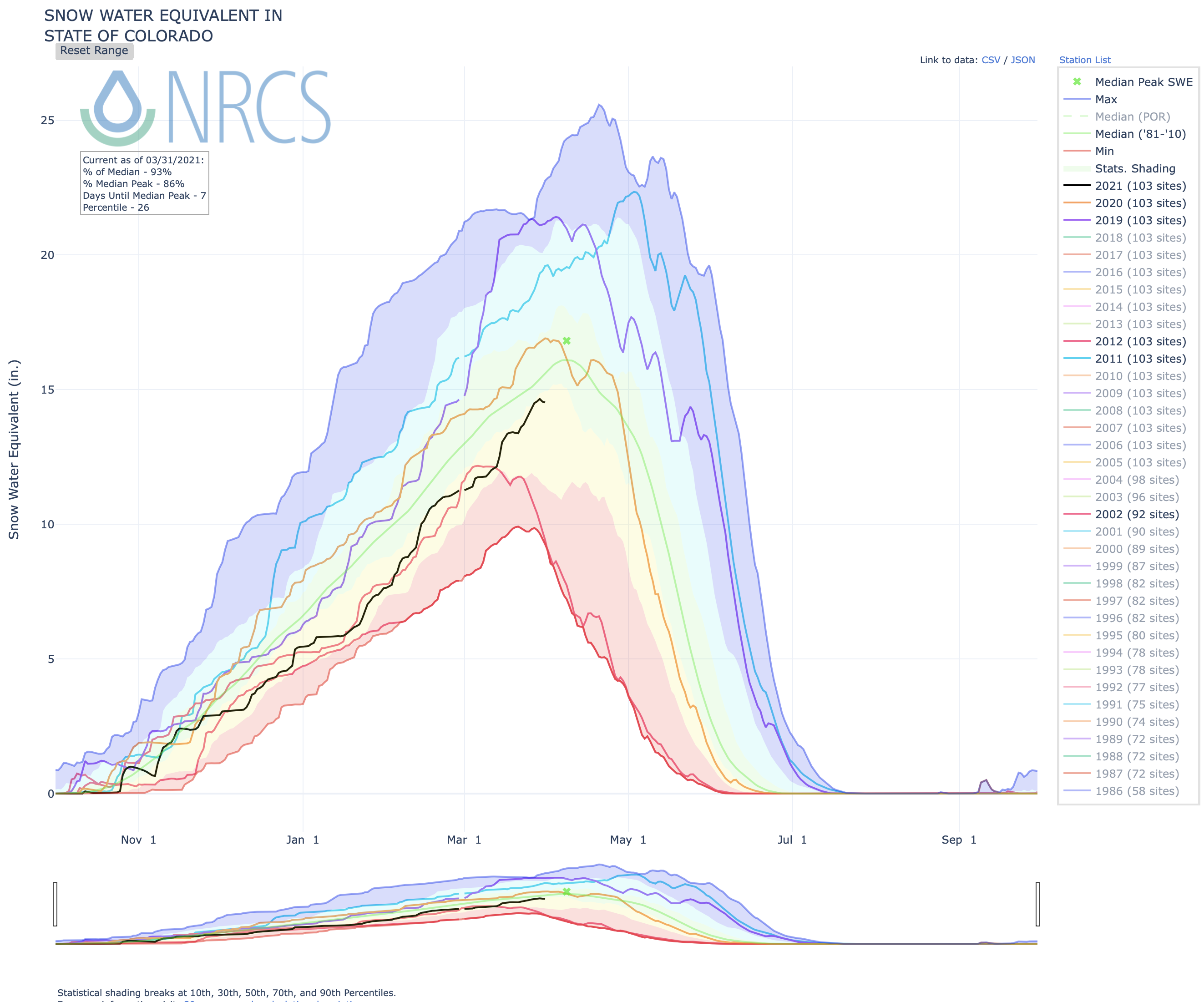
After the most recent snowstorms, snowpack in major drainages in Colorado now ranges from 105% in the Upper Rio Grande Basin to just 82% in the combined San Miguel/Dolores/Animas/San Juan basins. Statewide the snow water equivalent or the amount of water in the state’s snow, is at 92% of median.
Cotten was quick to caution everyone that while this is an optimistic note, stream flows in the basin remain below average. The immediate forecast for March through May 2021 is for above average temperatures and below average precipitation. Neither are the best news for water users.
Water scarcity, exportation threats and aquifer depletion were the topics of the day, as well as working toward sustainable practices to meet the challenges of an over-appropriated water system.
Water management has always been a challenge in this arid region. In the past communities across the San Luis Valley recognized these threats and worked together to protect the water.
Dan Birch of the Consensus Building Institute led an interactive session with attendees underlining the importance of the connections we make with each other. The San Luis Valley has a history of rallying to address water threats. Given the potential of another water export plan, the valley needs to rally together again.
Panelists: Representative Jeni Arndt, Colorado State House; George Whitten, San Juan Ranch, Saguache; James Henderson, 711 Ranch, La Jara; Kelsea MacIlroy, CSU; and Armando Valdez, Valdez Land & Livestock, Capulin. They shared viewpoints and discussed the challenges of water use in the valley.
In addition to water scarcity, aquifer depletion, and exportation threats, panelists touched upon the uncertain future for agricultural water users and the economic component of water. Water rights are also property rights and an emphasis on self-determination was evident in panelists’ comments.
Panelists agreed that connections with each other are important. We need to help each other understand the problems we are facing and problem-solve together.
Ken Salazar, former Secretary of the Interior and Co-Founder of the Salazar Rio Grande del Norte Center at Adams State University, called to mind the history of the valley facing export threats and solutions found over the years to continue to protect the water through legislation and conservation. In introducing the keynote speaker he called on attendees to focus on their love of the Rio Grande, lifeblood of water in the valley, when facing the challenges ahead.
Dan Gibbs, Executive Director of Colorado’s Department of Natural Resources, tied together an overview of statewide initiatives in water and forest health, the importance of conservation for outdoor recreation, as well as agricultural communities. They seek to improve the situation for all water users here in the San Luis Valley.
The symposium built on a deep history of innovation and water sharing, leaders, new and established, working to shepherd the culture and communities of the valley into a sustainable relationship with water. Weaving together challenges like climate change, growing pressure to the water supply, and renewed water exports with love for land and water and the desire to care for it.
The San Luis Valley has a history of sustainable water practices, connecting culture and the communities of the Valley. Working together, sharing a sense of place, is the path forward to ensure our collective future.
Rio de la Vista, Director, Salazar Rio Grande Del Norte Center closed the symposium: “The conversation will continue.”
The Salazar Center works to engage and advance education and the conservation of land and water along with the rich historic and cultural attributes at the headwaters of the Rio Grande.Find them at salazarriograndecenter@adams.edu.
Federal officials project low runoff in streams due to dry soil statewide
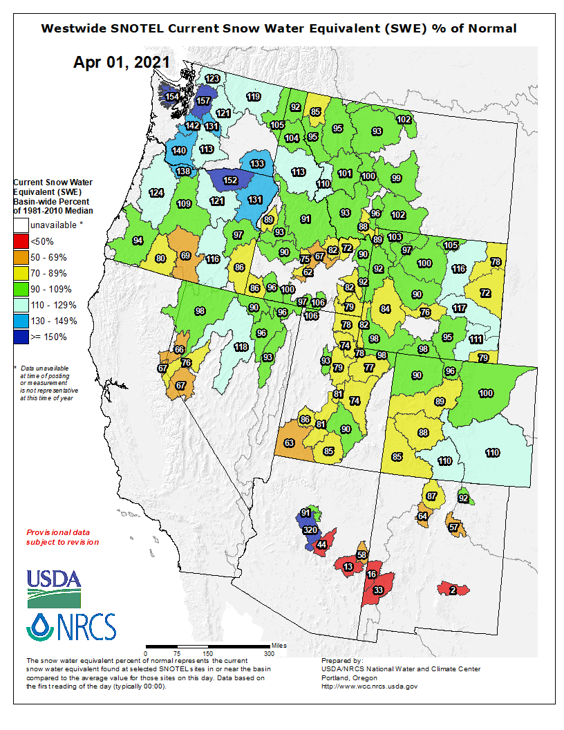
The snowpack in Colorado’s mountains has reached 93% of normal, federal survey data showed Tuesday — lagging slightly at the moment when cities and food growers decide whether water supplies will be sufficient for crops, cattle and a growing population.
While recent heavy snow bodes well, measured in relation to the norm between 1981 and 2010, federal forecasters on Tuesday also warned they’re expecting “below normal” water flows in streams and rivers once snow melts due to decades of mostly increasing aridity…
Colorado’s northern and eastern river basins generally received heavier snow.
Snowpack in the closely-watched Colorado River Basin — 40 million people and growers across seven western states rely on it — was at 89% of the norm.
Southwestern Colorado faced the driest conditions with snowpack measured in the combined San Miguel, Dolores, Animas and San Juan river watersheds at 87% of normal.
The South Platte River watershed had 102% of normal snowpack, and the level was 111% of the norm along the upper Rio Grande River. Arkansas River watershed snowpack was at 110%. In northern Colorado, snowpack along the Yampa and White rivers was at 91% of the norm, and the North Platte and Laramie watersheds had 97% of normal.