Near the tiny town of Red Cliff, three big cities conducted an experiment last fall. The Homestake Reservoir released a burst of water at the behest of the water utilities of Pueblo, Colorado Springs and Aurora. Their goal was simple: track a 1,600 acre-feet blob of water from the reservoir as it flowed to the Colorado state line.
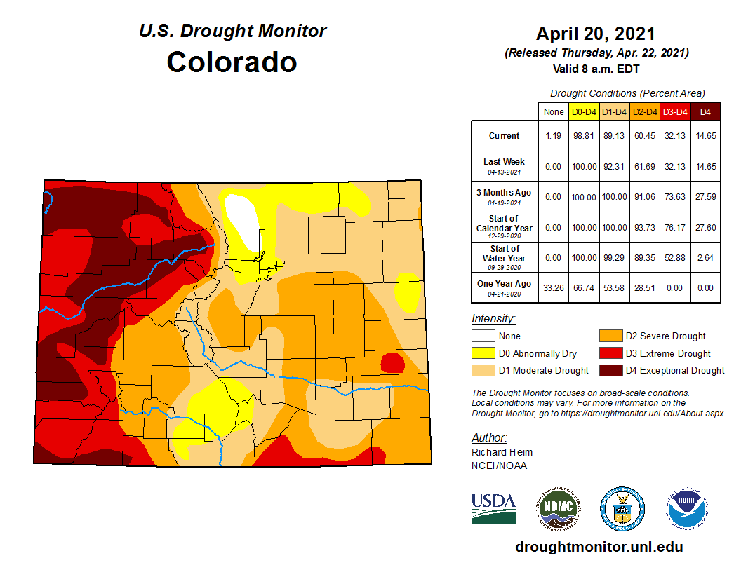
The experiment’s results were unsettling. The subsequent report, released this month, is a reminder on this Earth Day that our Western Slope rivers — some of the most intensely managed and measured in the world — do not amount to plumbing. They are wild, complex and continue to baffle our models and controls.
Homestake Reservoir is one of the state’s many trans-mountain diversions. The man-made lake collects water from the Eagle River watershed. Pipes and tunnels send that water under the Continental Divide and into the Arkansas River near Leadville. Once in the Arkansas River, further diversions bring that water to the Front Range.
But water managers used Homestake to send the burst of water in the other direction, into the Colorado River via the Eagle River. They then carefully monitored gages to see if the water reached Utah, a tracking exercise that in the jargon of the field is called “water shepherding.”
But by the time the Homestake water reached the stateline, state engineers could not determine how much of the water completed the journey.
This conclusion should open our eyes to the uncertainty that climate change poses for the Gunnison Valley and for the rest of the Western Slope. If we can’t use our reservoirs to send water downstream with any kind of precision, our prospects of slaking the thirsts of downstream states look bleak.
he basis of much of our water management, and the reason for conducting the Homestake experiment, is the 1922 Colorado River Compact. The agreement among southwestern states requires that Colorado send a minimum amount of water downstream to Nevada, California and Arizona. If we fail to meet that target, federal reservoirs like Blue Mesa would be used to release more water. But we assumed in the 1950s and 60s, (when, to build Blue Mesa Reservoir, we destroyed thousands of acres of farmland, one of the world’s greatest trout fisheries, drowned the towns of Iola and Sapinero and wiped out half of the Gunnison sage-grouse’s best habitat) that we could get the water from point A to point B.
The Homestake experiment shows that we don’t have the ability to deliver a given amount of water downstream. We don’t know how we would guarantee a certain amount of water flowing downstream to Nevada, California and Arizona.
If, for instance, the Upper Gunnison River Basin was called upon to increase Colorado River flows downstream, it would be “extremely difficult to track or quantify” the delivery, said Frank Kugel, former General Manager of the Upper Gunnison River Water Conservancy District.
It would be a “mammoth task,” Kugel told me. The resulting higher river levels would lead to more water pouring through headgates and onto hay fields. Dry soils along the Gunnison and Taylor rivers would soak up some of the water. And then the three reservoirs and dams (Blue Mesa, Crystal, Morrow Point) in the Aspinall Unit would muddle the picture further. And that’s all before the Gunnison Tunnel would shunt hundreds of cubic feet per second into the Uncompahgre River Valley.
To just detect the delivery of water, much less to measure it, would require a very large release from the Upper Gunnison River Basin, Kugel told me.
Both Kugel, as well as Sonja Chavez, the current general manager at the Upper Gunnison River Water Conservancy District, told me that the difficulties of water shepherding contribute to their skepticism of “demand management” — a massive effort by Colorado water managers to determine how to best cut water use.
“The whole issue of shepherding is huge,” Chavez said. Demand management might sound good on paper, but the legal implications and the water shepherding implications throw doubt on the implementation of a statewide demand management program.
“The ability to track water that is conserved consumptive use all the way to the state line is really critical for the success of that program,” Colorado River District General Manager Andy Mueller told Aspen Journalism on the subject of the Homestake experiment. “And if you can’t track a slug of 1,600 acre-feet of water to the state line, how are you going to track the voluntary reduction in use of a small ditch on the West Slope that maybe they are saving 15 acre-feet?”
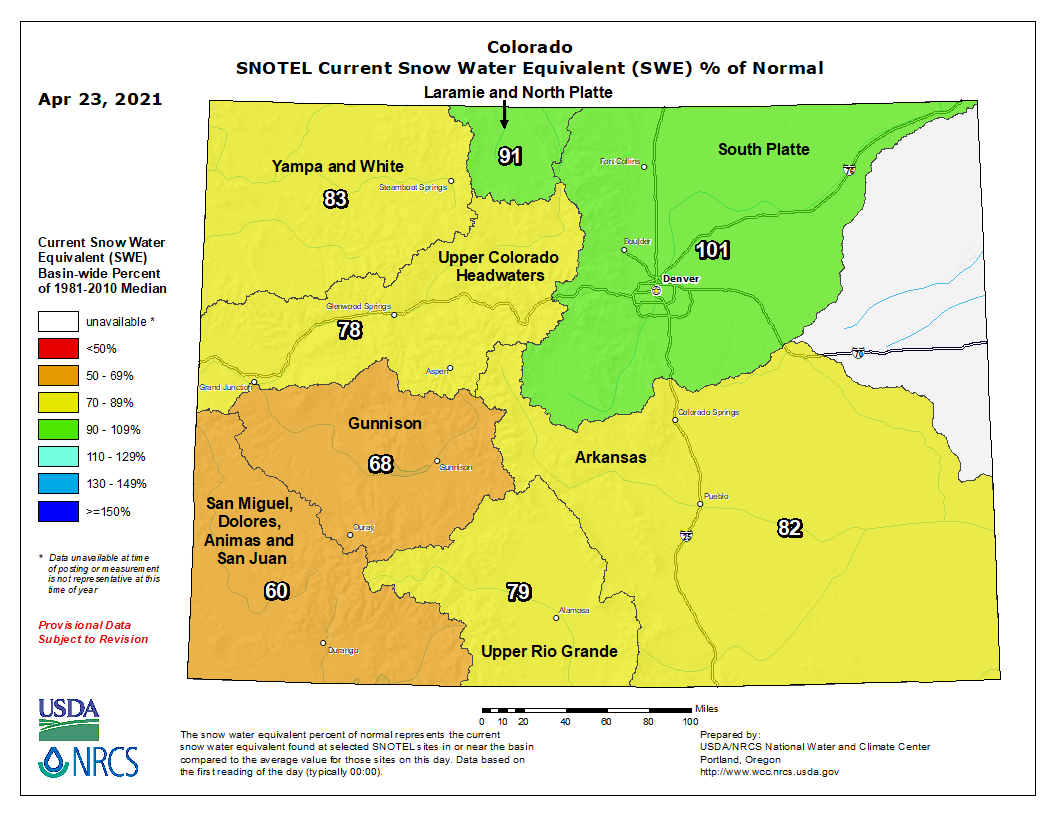
Water shepherding experiments will continue because the state has to figure out how to deliver more water downstream. Colorado has set its sights on storing 500,000 acre-feet of water in Lake Powell to protect against the increasingly likely scenario that too little water will flow to Nevada, California and Arizona. But, as shown in the Upper Gunnison River Water Conservancy District’s supply report for this week, that 500,000 acre-feet buffer may not be enough. Lake Powell will release about 8 million acre-feet this year. Only about 5 million acre-feet are expected to flow in.
“Throwing 500,000 acre feet down there will not do much if it stays hot and dry and if the flows do not materialize,” Chavez said.
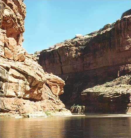
Next time you drive by Blue Mesa Reservoir, this news may put its waters in a different light. We don’t know how to deliver water through rivers, but we do know how to dam them. And as Lake Powell is expected to fill to just 33% of capacity this year, our limited knowledge may not be enough.