
From The Tri-State Livestock News (Ruth Wiechmann) via The Fence Post:
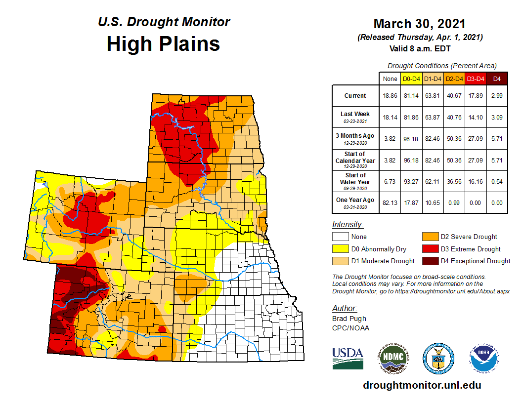
The United States Drought Monitor continues to indicate a critical lack of moisture for much of the Great Plains. March snowstorms brought a bit of relief to some areas but forecasted warmer and drier than normal conditions for the foreseeable future stand poised to suck the soil dry again.
Adnan Akyuz, North Dakota state climatologist at North Dakota State University, says that it is unusual for North Dakota to be so dry this time of year.
“This extreme level of drought is unusual,” he said. “Our Drought Severity and Coverage Index is sitting at 331 right now, the highest on record since 2000. This does make it look like we are in the worst drought, but we are just looking at one facet of the data in the DSCI. We also need to consider the accumulated impact of drought over time. Based on the accumulated DSCI the current conditions follow the drought of 2002-05, 2017-18, 2008-09, 2012-13, and 2006-07. However, we have to keep in mind that the growing season has just started and the impact will accumulate.”
[…]
Akyuz is concerned for the long term, with 47 percent of the state experiencing Extreme Drought (D3) and 100 percent of North Dakota in Moderate Drought (D1) or higher according to the U.S. Drought Monitor. He said that the lack of the usual snow cover through the past winter is significant…
It’s a perfect storm, and it’s turning into dust storms across the area. Akyuz said that extension agents across North Dakota sent him photos following recent wind storms clocking gusts up to 79 miles per hour that are reminiscent of the photos of dirt drifts from the Dust Bowl years of the 1930s.
“I don’t think we’ve ever had a drought that compares with the ‘Dirty Thirties,’” he said. “There was no significant precipitation to mitigate that drought for a decade. The 1930 drought was finally over in 1941 with precipitation that year adding up to the wettest growing season on record for North Dakota. We’re not there yet but I don’t see a significant change in weather patterns coming soon.”
Akyuz said that in spite of their severity, current conditions do not match the intensity of Exceptional Drought (D4) conditions seen in 2006 and 2017, nor the extended periods of drought seen in the 1950s and in the six-year drought spanning 1987-1992…
A mid-March snowstorm brought some relief to areas of southern South Dakota, much of Wyoming and Nebraska, but Tony Bergantino, climatologist at the University of Wyoming, is concerned that the benefit could be short lived…
While Wyoming tends to be on the dry side, and Bergantino says that drought is certainly not unprecedented, he sees current conditions and predictions for the coming months pointing to below normal precipitation and above normal temperatures.
“I’m hoping for more moisture,” he said, “But it looks like we could see something similar to the 2012 drought or the dry years in the early 2000s. One thing that helped us in 2012 early on was that we were coming off a year of really good snowpack which helped fill the reservoirs. So we were in better shape going into 2012. 2020 was not good at all so we have a double whammy going into 2021.”
[…]
Laura Edwards, South Dakota State University’s Extension state climatologist in Aberdeen, said that parts of the northern tier of South Dakota counties have seen no measurable precipitation in March, when moisture amounts normally start to increase in the state.
