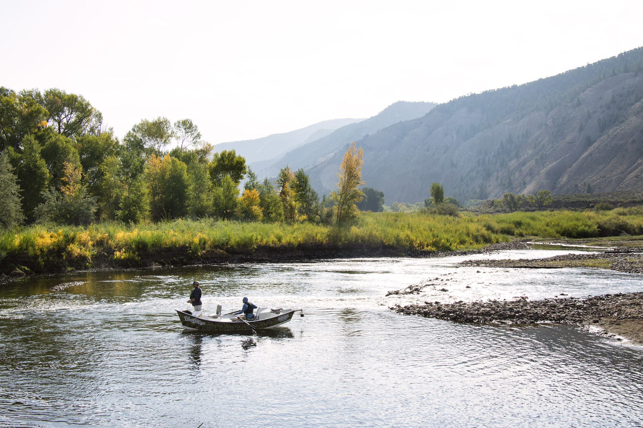
Two men fish the Eagle River just above its confluence with the Colorado River in Dotsero. Homestake Partners released 1,667 acre-feet of water down Homestake Creek and into the Eagle River in September to test how a release would work in a compact call. CREDIT: BETHANY BLITZ/ASPEN JOURNALISM
Getting water to state line would be key in compact call
In September, Front Range water providers released some water downstream — which they were storing in Homestake Reservoir — to test how they could get it to the state line in the event of a Colorado River Compact call.
But accurately tracking and measuring that water — from the high mountain reservoir in the Eagle River watershed all the way through the Colorado River at the end of the Grand Valley — turned out to be tricky, according to a recently released report from the Colorado Division of Water Resources.
From Sept. 23 through Sept. 29, Colorado Springs Utilities, Aurora Water and Pueblo Board of Water Works released a total of 1,667 acre-feet of water, which would have otherwise been diverted to the Front Range, from the reservoir into Homestake Creek, a tributary of the Eagle River. The release gradually ramped up from about 25 cubic feet per second to 175 cfs and then gradually back down over the seven days.
But officials were unable to put a number on how much of that water made it to the state line.
In their attempt to quantify the actual amount of reservoir release delivered to the state line, state engineers ran into challenges that caused uncertainty, they said in an email.
Although they couldn’t measure how many acre-feet officially made it, State Engineer Kevin Rein said that the exercise was still a success and that all the water, minus transit losses, crossed into Utah.
“We have heard this is a failure because not everything worked perfectly, but in my mind, this was an opportunity under non-stress conditions to find out what we need to do to ensure that things will work,” Rein said.
A goal of this project, known as the State Line Delivery Pilot Reservoir Release, was to see if the water could be “shepherded” downstream without senior water-rights holders diverting the extra water. This required Division 5 water commissioners to actively administer some headgates, especially on Homestake Creek and the Eagle River.
According to the report, the water took about 2½ days to make the journey from the reservoir to the gage on the Colorado River near Cameo — about 16 hours longer than predicted by the Colorado Basin River Forecast Center. Along the way, about 10% of the water either evaporated or was soaked up by thirsty streamside soils and vegetation — processes known collectively as transit loss.
Making sure water could get to the state line would be essential in the case of a compact call.
This scenario, the chances of which increase as climate change continues to reduce river flows, could occur if the upper-basin states (Colorado, Wyoming, Utah and New Mexico) can’t deliver the 7.5 million acre-feet of water per year to the lower-basin states (Arizona, California and Nevada), as required by a nearly century-old binding agreement.
A compact call could be especially problematic for Front Range water providers since most of their rights that let them divert water over the Continental Divide from the Western Slope date to after the 1922 Colorado River Compact. That means mandatory cutbacks in water use could fall more heavily on the post-compact water rights of Front Range water providers.
Colorado Springs Utilities and Aurora Water, operating together as Homestake Partners, said the problem was that the rate of release was too low. It was more a matter of flow volume than administration. Even in a dry year, a release of 175 cfs was not high enough to reliably track the water, especially when it reaches the Colorado River, which has a much higher volume of water than Homestake Creek or the Eagle River, and the reservoir release is a smaller fraction of its overall flow.
In an email to Aspen Journalism, Homestake Partners said: “A bigger pulse of water would overcome some of the issues that DWR had in tracking the release. This sort of result is exactly what we wanted to explore — it tells us that if we, or anyone else in the state, chooses to make a state line release in the future, a higher volume of water will probably need to be released to be reliably tracked.”
State engineers also had to deal with a river that was constantly in flux. Upstream reservoir releases and changes to irrigation diversions made for additional challenges.
State officials said it was hard to separate the reservoir release from the rest of the Colorado River’s flow at the state line because of numerous ungaged streams and return flows from irrigation that enter the river between Palisade and the state line.
“The ungaged inflows could not be subtracted from the total flow in the river, therefore the separated flows were too large and did not allow for the initial waves of the reservoir release to be identified,” officials said in an email.
The total flows at the state line at the time of the reservoir release’s arrival were around 2,500 cfs, according to DWR.
The total flows at the state line at the time of the reservoir release’s arrival were around 2,500 cfs, according to DWR.
River District concerns
The Glenwood Springs-based Colorado River Water Conservation District, which protects Western Slope water interests, had several concerns about the reservoir release.
“I think it’s important that the public and the state recognize that they released 1,600 acre-feet of water during an incredibly dry period and they couldn’t actually track it to the state line,” said River District general manager Andy Mueller.
But Mueller’s concerns go beyond the trouble with tracking. He said the state engineer did not reach out to Western Slope water users who had the potential to be injured by the release. He also doesn’t trust that the cities won’t just refill the hole created by the release with more Western Slope water.
The River District’s main concern is that in a water-collection system as complex as Homestake Partners — with several different transmountain diversions bringing water from the Western Slope to the Front Range — it’s hard for the state to make sure they won’t take more water to replace the pool they released.
“From our perspective, it’s very difficult for the state to verify that they haven’t just brought the water over from a different part of their diversion system,” Mueller said. “So it leaves us with a lot of skepticism, and we voiced that in several discussions.”
To address some of these concerns, the cities are required to submit a verification plan to the state to prove three things: that they had enough space available in reservoirs on the east side of the divide to store the water, and they weren’t just releasing water downstream they couldn’t use anyway; that they actually decreased water taken through the Homestake Tunnel by the same amount as the pilot release; and that they didn’t create additional space in Homestake Reservoir to allow for greater storage this year.
“In essence, we brought the ‘hole’ we created in our storage in Homestake Reservoir through to the East Slope when we operated the tunnel in February and March,” the Homestake Partners’ email reads. “This was accomplished by not drawing down Homestake Reservoir quite as much as we otherwise could have this winter in preparation for spring runoff.”
Homestake Creek flows from Homestake Reservoir near Red Cliff. A pilot reservoir release to test how to get water to the state line in the event of a Colorado River Compact Call proved hard to track for state engineers. CREDIT: BETHANY BLITZ/ASPEN JOURNALISM
Demand management
The reservoir release also could have implications for a potential demand-management program, the feasibility of which the state is currently investigating. At the heart of a demand- management program is a reduction in water use on a temporary, voluntary and compensated basis in an effort to send as much as 500,000 acre-feet of water downstream to Lake Powell to bolster water levels in the giant reservoir — which spans Utah and Arizona — and, indirectly, to meet Colorado River Compact obligations.
Under such a program, agricultural water users could get paid to temporarily fallow fields and leave more water in the river. Front Range water providers could participate by releasing water stored in Western Slope reservoirs.
Rein was careful to say that the Homestake pilot release was in no way connected to demand management. Still, the experiment may have revealed potential problem areas should a demand-management program become reality.
“The ability to track water that is conserved consumptive use all the way to the state line is really critical for the success of that program,” Mueller said. “And if you can’t track a slug of 1,600 acre-feet of water to the state line, how are you going to track the voluntary reduction in use of a small ditch on the West Slope that maybe they are saving 15 acre-feet?”
Aspen Journalism covers rivers and water in collaboration with the Vail Daily and The Aspen Times. This story ran in the April 16 edition of the Vail Daily and The Aspen Times.
As the city’s infrastructure grows older and federal and state governments increase their standards for environment and watershed health, the city’s general fund has faced a significant strain in trying to keep up, Steamboat Water Resourced Manager Kelly Romero-Heaney and Steamboat Public Works Director Jon Snyder told council members Tuesday…
The idea is still under consideration, but if council chose to move forward, Steamboat residents would pay a small fee that would go toward protecting water quality. While an exact amount has not been decided yet, Romero-Heaney said the fee would be less than what residents currently pay for water and sewer bills. Aspen and Silverthorne recently enacted a storm water utility fee, and Romero-Heaney said the city would likely look to those communities for guidance.
Tuesday was the first time council members discussed such a move, and their first step would be to hire a consultant to study whether or not the idea is feasible in Steamboat…
City staff estimated the consultant would cost between $50,000 and $100,000, which could either be included in the 2022 budget proposal, or if the council would like to move sooner, could be added as a supplemental ordinance to the 2021 budget…
Council members tabled the discussion until their July work session.
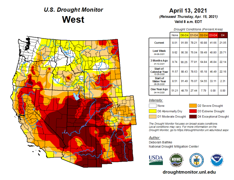
The lack of water worsens drought conditions, fire potential and could impact agriculture
The snowpack season is ending in the Colorado River Basin as the spring melt is underway. If we take stock of the water supply over this vast basin, a critical resource for millions of people in the West, the news is not good.
The snowpack season, so important for the storage of water that can be tapped during the dry summer months, fell well short of expectations. The consequences of the shortfall for the basin, encompassing Arizona and parts of six other states, from Wyoming to California, are major.
1. There is an increased risk for large wildfires that can devastate state and national forests, reduce summer recreation activities, compromise air quality for large areas of the country and put populations near the urban-forest intersections in danger.
2. The reduced water supply affects municipal and agricultural water users not only within the basin’s 246,000 square miles, but also outside it, including Denver, Salt Lake City and Los Angeles.
3. Prolonged drought could ultimately affect food supply, causing reductions in crop yields and livestock herds.
To put this season in perspective, I’ve made a report card of the various indicators of snowpack to illustrate why the low grades are so serious.
The snowpack itself: C
The snowpack picture seemed promising at times in recent months, especially in February when several storms unloaded hefty snows. Even now, some late season snow in the northern part of the basin is working in some extra credit. But it’s not enough.
At the headwaters of the Colorado River, the snowpack peaked on April 2, about 10 days ahead of average. Since then, more than two inches of water have melted. In fact, since the beginning of April, the majority of stations in the upper Colorado River basin have seen melt rates between 2 and 6 inches. When the snowpack peaks and melts early it often portends a lower water supply during the dry season.
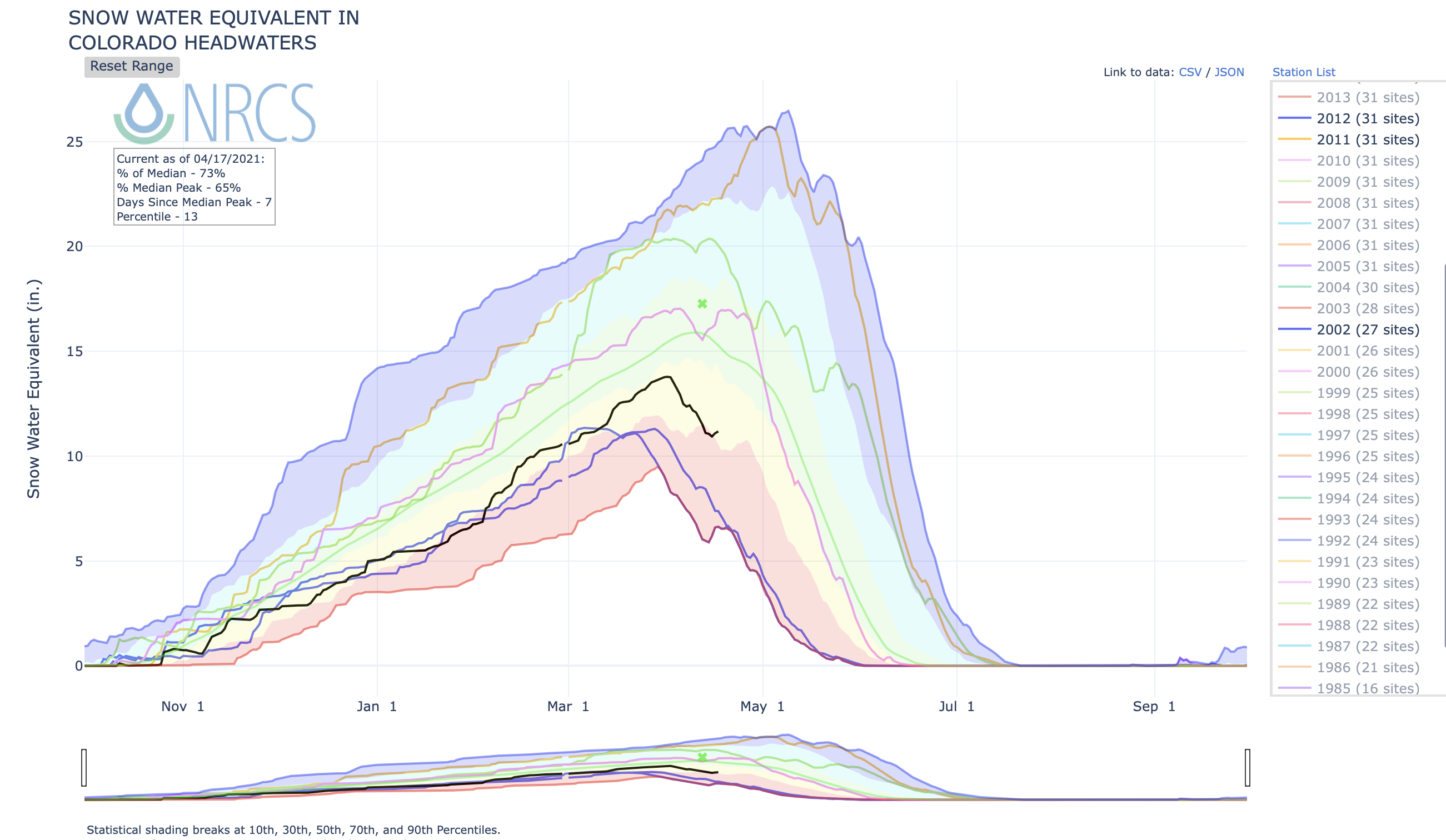
The progression of snow water equivalent, an indicator of snowpack, in 2021 in the Colorado River Basin compared to other years. (Natural Resources Conservation Service)
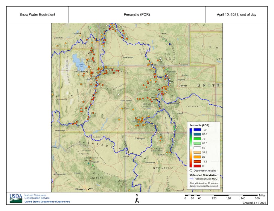
Indeed, throughout the entire Colorado River Basin, snowpack values peaked at levels well below average. From the Upper Green Basin in Wyoming and south through Utah and Colorado, many locations peaked in the bottom 25th percentile.
Snow water equivalent percentiles, an indicator of snowpack, as of early April (Natural Resources Conservation Service)
Soils: F
Soils have been the problem child since the very beginning of the water season, when the summer-fall monsoon was essentially a no-show.
If the monsoon had provided the needed moisture in June-September to the lower part of the basin and the southern portion of the upper basin, healthy soils would have been locked in during the cold season. But without the monsoon moisture, the basin went into the snowy part of the season with dry soil, essentially saddling the water supply with a debt that is far from being repaid.
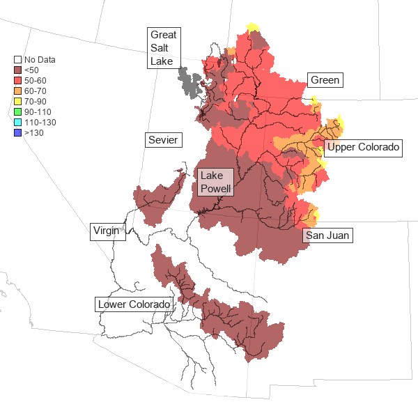
Map credit: USGS
Streams: D
Stream flow data doesn’t look too bad at the moment. According to the U.S. Geological Survey, the percent of the upper part of the basin observing near normal flow conditions has actually increased from 21 percent to 42 percent. But don’t let that deceive you.
Late in the water season, streams often appear to be doing better than they actually are. So, what’s happening?
(U. S. Geological Survey)
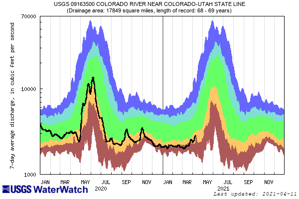
Check out the hydrograph (above) from the Colorado River at the Colorado-Utah state line. The black line shows the average flow in recent months, compared with historical values (indicated by the colored shading).
Back at the beginning of March, flows were in the brown shading, ranking in the bottom 10th percentile. More recently, you can see that flows have bumped up to the yellow category, slightly improved from the brown. But this bump is mainly due to an early rise toward the peak. That early rise has been kicked off by early melting of the snow. The “improvement” is only an artifact of the early snow melt and will not be sustained.
Reservoirs: D
The water stored in reservoirs is akin to the output of a group project, contingent on the performance of its contributors. Since snow quantities, soil moisture and streams underachieved, reservoirs also end up with a low grade.
Water Supply Outlook April 1, 2021 via the Colorado Basin River Forecast Center
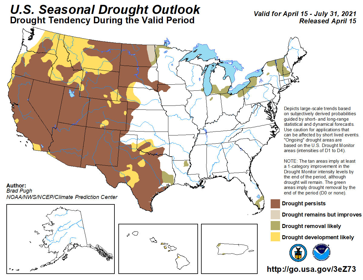
According to the April 1 water supply forecast, published by the Colorado Basin River Forecast Center, all of the Colorado River Basin will experience below-average water supply.
Across the Lower Colorado River, water supply accumulations began in January and most of the snow has completely melted. For the Lower Basin and southern half of the Upper Basin, water supplies are expected to be below 50 percent of average. Lake Powell inflows are forecast at 38 percent of average, a deficit of almost 4 million acre-feet! For perspective, current levels are already 6 million acre-feet below what they should be right now.
Further north, the forecast is marginally better, with water supply expected to be between 50 and 70 percent.
These low forecasts are largely based on less than stellar snowpack conditions, but dry soil moisture conditions at the beginning of the season are also considered. According to Cody Moser of the Colorado Basin River Forecast Center, antecedent soil moisture conditions can make a 5 to 10 percent difference in predicted runoff.
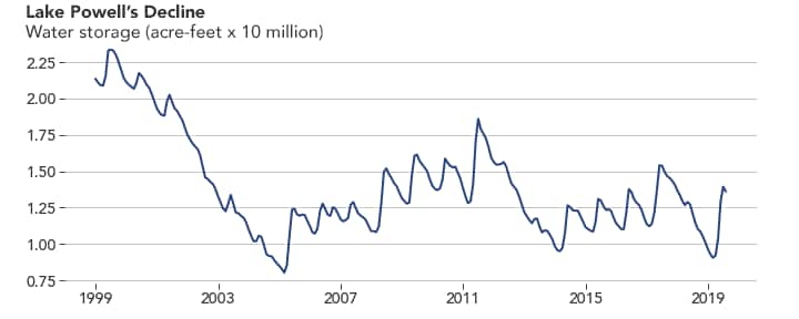
Lake Powell water supply 1999 to 2019.
Lake Powell, which represents the majority of the Upper Colorado River Basin’s water supply, has still not recovered from the drought in the early 2000s. It takes more hits from each new drought. The system had a nice recovery from the 2018 drought, but still hasn’t made up lost ground from another drought in 2012-2013. Unfortunately, we’ll put 2021 down as another year to further deplete this system.
Becky Bolinger is the assistant state climatologist for Colorado and a research scientist at Colorado State University.
In a photo from 2020, a distinct line around the rocky shore shows how much the water level has decreased in Nevada’s Lake Mead. Mead is expected to drop 15 feet in 2021 Photo credit: Roberto (Bear) Guerra/High Country News
The latest Bureau of Reclamation reservoir projections, which take into account river flows in a given year, show a likelihood that Lake Mead on the Arizona-Nevada stateline will dip below the critical threshold of 1,075 feet in elevation in May and remain below that level for the foreseeable future.
A first-ever official shortage declaration from the Department of the Interior is almost certain later this year. According to the terms of a 2007 agreement, a shortage is declared by the Interior Secretary after consulting with water users in the Lower Basin states of California, Arizona and Nevada. An August report is used to forecast when Lake Mead will be below 1,075 feet at the start of a calendar year.
Extreme to exceptional drought conditions have blanketed more than 75% of the river’s upper watershed for more than eight months. The majority of the river’s water comes from high mountain snowpack in Colorado and Wyoming. Both states are dealing with drought of varying degrees of severity.
“Current conditions resemble 2002, 2012, 2013 and the beginning of 2018, four out of the five driest years on record,” the Bureau of Reclamation report notes.
The Colorado River’s two biggest reservoirs, Lakes Mead and Powell, have been unable to recover from sustained hot and dry conditions for the last 21 years, a phenomenon scientists link to human-induced climate change. Warmer temperatures have increased the amount of evaporation from streams and reservoirs, raised demand for water in forests and on crop fields, and changed precipitation from snow to rain. Snow acts as a large, frozen reservoir that melts slowly over months, while rain is harder to capture and dole out to farmers, cities and other users.
Top water officials in Arizona and southern California say they are prepared for the coming cutbacks to their water supplies. If the dry conditions hold, Arizona, Nevada and Mexico could take increasingly steep cuts to what they’re allowed to divert from the river. California could also see its river allocation restricted if the declines continue.
The basin has flirted with a shortage declaration for the last decade but has been aided by short-term boosts in snowpack, coordinated releases of water between Lakes Powell and Mead, and voluntary conservation by Lower Basin water users. Arizona, Nevada and Mexico have already been curtailed due to restrictions laid out in the 2019 Drought Contingency Plan. A shortage declaration will make those cutbacks even steeper.
In response to the latest projections, the Central Arizona Project and the Arizona Department of Water Resources issued a joint statement. In it, the agencies assure users the state’s top water officials had been anticipating the news.
“The study, while significant, is not a surprise,” the statement reads. “It reflects the impacts of the dry and warm conditions across the Colorado River Basin this year, as well as the effects of a prolonged drought that has impacted the Colorado River water supply.”
Jeff Kightlinger, general manager for the Metropolitan Water District of Southern California, said in a statement the watershed so far has been able to avoid a shortage declaration because of voluntary conservation efforts. But climate change is deepening the Colorado River’s supply and demand imbalance to the point where mandatory cutbacks are coming.
Water Supply Outlook April 1, 2021 via the Colorado Basin River Forecast Center
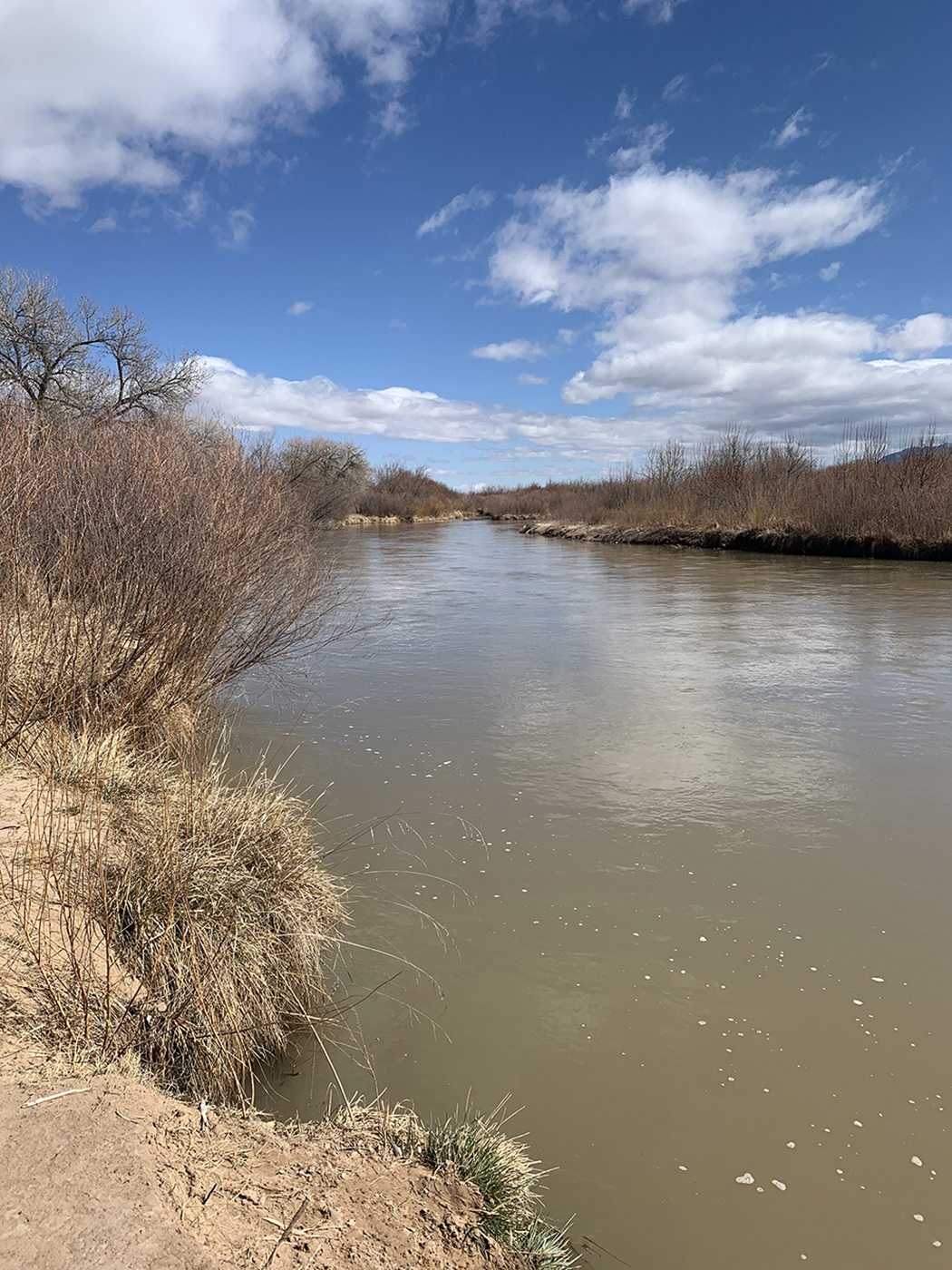
Rio Grande upstream near Montano, NM. Photo credit: USBR
Here’s the release from the Bureau of Reclamation (Mary Carlson):
The Bureau of Reclamation and U.S. Army Corps of Engineers released their Annual Operating Plan for the Rio Grande [April 15, 2021] showing below average runoff for the second year in a row.
The amount of water in the snowpack (snow water equivalent) measured in the mountains of northern New Mexico and southern Colorado feeding the river basin is below average and a below average spring runoff is expected for the Rio Grande in New Mexico. Most reservoirs on the Rio Chama, Rio Grande, and Pecos River are holding between 10% and 50% of their capacity heading into the irrigation season. In addition, the amount of moisture in the soil right now is extremely low, compounded by high temperatures, so much of the melting snow may be absorbed or evaporate before it reaches rivers.
“We continue to learn more about the Rio Grande and Pecos and the species that rely on them as we manage through extended drought in the region,” said Albuquerque Area Manager Jennifer Faler. “We are in close coordination with water and species management partners to ensure we make the best decisions for all water users and for the health of the rivers in a tough year like this.”
At the end of March, snow water equivalent was 88% of average for the Rio Chama Basin, 111% of average for the Upper Rio Grande Basin, 72% for the Sangre de Cristos, and 65% for the Jemez. Based on these values, the Natural Resources Conservation Service streamflow forecast issued for the month of April predicts that the Rio Chama flow into the El Vado Reservoir will be at 52% of its average, with an inflow of about 116,000 acre-feet of water.
Information from Annual Operating Plan:
Under current Rio Grande Compact storage restrictions triggered by low storage at downstream reservoirs, water can only be stored in El Vado for the Prior and Paramount lands of the six Middle Rio Grande Pueblos. The Middle Rio Grande Conservancy District began irrigation on April 1, a month later than usual, with the natural flow of the Rio Grande.
Due to the expected low runoff, lack of water in storage, as well as a minimal supply of water for Reclamation to lease to supplement river flows, there—s a possibility that the Albuquerque reach of the Rio Grande could experience some drying this summer along with sections of the river in the Isleta and San Acacia reaches.
Reclamation is coordinating with U.S. Fish and Wildlife Service to rescue fish from drying portions of the river and coordinating with partners to use the limited supply of water most effectively.
Rio Grande Project usable storage is currently about 245,000 acre-feet and is expected to peak at about 350,000 acre-feet before declining as irrigation releases start.
The irrigation season is scheduled to begin with releases from Elephant Butte Reservoir in early May and Caballo Reservoir in late May.
The dry riverbed between Elephant Butte and Caballo and below Caballo will take on water quickly. As such, it will be both unpredictable and dangerous and the public is asked to exercise caution around the river channel. Water levels will fluctuate through the rest of the short irrigation season.
On the Pecos River, basin-wide snow water equivalent was 57% of average on March 31, and the NRCS predicted 16,200 acre-feet of inflow to Santa Rosa Reservoir from March to July.
Reclamation is using a more conservative estimate for inflow, and the Carlsbad Irrigation District has only allocated 0.38 feet per acre, one of its lowest allocations ever.
Rio Grande and Pecos River basins. Map credit: By Kmusser – Own work, Elevation data from SRTM, drainage basin from GTOPO [1], U.S. stream from the National Atlas [2], all other features from Vector Map., CC BY-SA 3.0, https://commons.wikimedia.org/w/index.php?curid=11218868
Sant Fe River bed, which is augmented or replenished shortly below by releases form the city’s wastewater treatment plant. “Headwaters,” so to speak. Photo credit: Allen Best April 10, 2021.
Sant Fe River bed, which is augmented or replenished shortly below by releases form the city’s wastewater treatment plant. “Headwaters,” so to speak. Photo credit: Allen Best April 10, 2021.
Santa Fe, New Mexico, once was sustained by the waters of the Santa Fe River, which begins in the high country of the Sangre de Cristo Mountains, flows through the city and then onward to the Rio Grande.
But when Western cities grow, they look everywhere for more water, with little regard for the rivers they drain. As the city’s population grew, Santa Fe turned to its groundwater. Later, New Mexico reached across the desert to take water from the Colorado River and deliver it to Santa Fe, Albuquerque and other beneficiaries on the Rio Grande.
And yet the Santa Fe River downstream was not reduced to a dry and dusty arroyo. In fact, the riverbed is relatively verdant, supporting cottonwoods, willows and sustaining some irrigation in communities downstream. That moisture helps make Santa Fe a beautiful place in the desert.
That’s because the water that Santa Fe residents use to flush their toilets or pour down the drain ultimately makes its way to the wastewater treatment plant, which returns the treated water to the Santa Fe River. That could soon change.
The city’s water bureaucrats have fastened on the idea of capturing some of that treated effluent, either to get additional “return flow” credits by returning it to the Rio Grande, or by moving to direct potable reuse, a process derided in California as “toilet to tap.”
But both of these proposals will also take water out of the Santa Fe River, affecting downstream irrigators, wildlife and even the cultural identity of the region.
As climate change tightens its grip on the arid West, water managers are focusing on wastewater as a source of “new” water for cities. It’s hard to blame them: Municipalities don’t need new water rights in order to reuse treated effluent.
Communities dump their treated sewage into rivers, and downstream users draw that water, treat it, and send it to residents’ homes. Orange County and Irvine Ranch in California are pioneers in recycling wastewater. The Bureau of Reclamation now administers a fund for water-reuse projects, and the Environmental Protection Agency has made it a national priority.
There’s another strategy that Western cities like Santa Fe are exploiting to make use of their wastewater. Instead of sending all of the treated wastewater back into the potable water supply, Santa Fe plans to send some of its wastewater to the Rio Grande via a $20 million pipeline. This would give the city the right to pump additional water from the Rio Grande. Regardless of how the city proceeds, the Santa Fe River will end up losing some of the water that provides for its existence.
Never forget that Western water law was set up to serve users, not rivers. And under Western states’ laws, cities own their treated sewage, meaning they can use it or sell it downstream as they wish. In fact, wastewater is such a reliable supply that it gets top value at Western water auctions.
Santa Fe’s webpages overflow with the community’s commitment to sustainability. But these values were disregarded in the city’s focus on squeezing more water out of the system for a growing populace.
Wastewater has other values and uses, though. How do we draw attention to them? A report by the National Wildlife Federation, the Pacific Institute and the Meadows Institute warns that reusing water can inadvertently “starve natural systems of needed flows and potentially reduce water available to communities downstream.”
Instead, the groups urge planners to “incorporate actions to protect (and where possible, enhance) river flows downstream for the benefit of people and the environment” https://pacinst.org/publication/healthy-waterways/.
By now, years of battles over Western water should have taught water managers that while people value reliable water supplies, they also value living rivers, small farms, historic communities and recreation. The report urges water managers to consult with the public before making decisions. It also lays out a blueprint for incorporating the value of living rivers, as well as addressing water supply.
Wringing more use from water, even wastewater, is a powerful tool in addressing water scarcity. But just like the dams, pipelines and other tools of the Cadillac Desert era, wastewater ought to be approached with respect for all of its values. The proponents of water reuse need to acknowledge this.
Denise Fort is a contributor to Writers on the Range, writersontherange.org, an independent nonprofit dedicated to lively conversation about the West. She is professor emerita at the University of New Mexico School of Law and has co-authored three reports for the National Academies on water reuse.
Vail Mountain has seen quite a melt over the last two weeks, and snow telemetry data shows the area snow water equivalent to have peaked on March 31.
While there’s more moisture on the way, it’s unlikely to push the readings on the Vail Mountain snow telemetry site back over the March 31 recordings at Vail, said Eagle River Water and Sanitation District spokesperson Diane Johnson.
The Vail Mountain site is located at an elevation of 10,300 feet, and peaked March 31 at 14.6 inches of water within the snowpack, known as snow water equivalent.
The March 31 peak at 14.6 inches is 65% of normal peak SWE and 3.5 weeks ahead of the normal April 25 peak, Johnson said.
Johnson said while the rain and snow in the forecast is very welcome given the conditions, “it’s unlikely to affect the peak since Vail has already dropped so much.”
The April 12 reading on Vail Mountain is 11.5 inches, down 3.1 inches in two weeks…
Copper Mountain’s SWE peaked April 2, nearly four weeks ahead of its normal April 28 peak. The site recorded 12.4 inches of water within the snowpack, which is 80% of its normal peak. The Copper Mountain snow telemetry site is at 10,550 feet and is the closest official measurement site to the headwaters of Gore Creek, which runs through Vail Village.
At Fremont Pass, which is the site closest to the headwaters of the Eagle River, an April 5 reading shows 13.4 inches of water within the snowpack, which could be the peak, although it’s still too early to tell, Johnson said. The April 12 reading at Fremont Pass shows 13.2 inches…
The Eagle River Water and Sanitation District says the extreme drought which started in August 2020 is likely to continue into this summer.