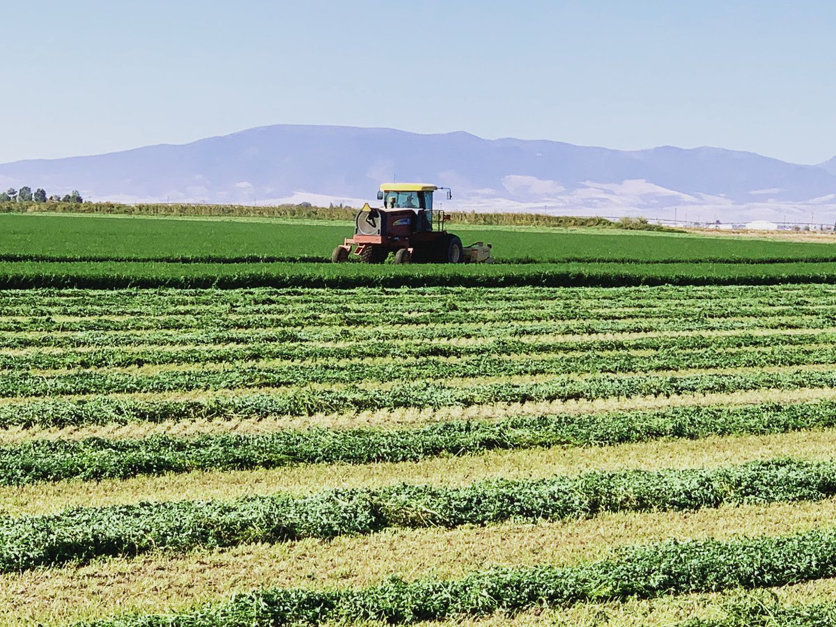
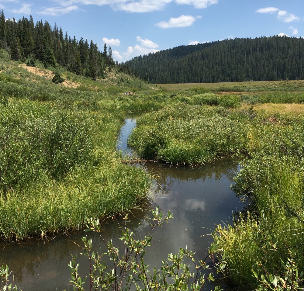
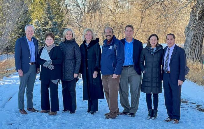
Third hay cutting 2021 in Subdistrict 1 area of San Luis Valley. Photo credit: Chris Lopez
Click the link to read the article on The Denver Post website (Conrad Swanson). Here’s an excerpt:
Trouble swirls above the aquifers of Colorado’s San Luis Valley, where farmers and ranchers raise and grow much of the region’s cattle, potatoes, alfalfa and barley. Those aquifers are losing water as the American West dries out and whatever remains is spoken for. Farmers and ranchers have labored for decades to use less of the valley’s most precious resource. Today, the farmers say, a new but familiar threat approaches.
Denver Basin Aquifer System graphic credit USGS.
A Front Range company called Renewable Water Resources, backed by a cadre of builders, developers and former Colorado Gov. Bill Owens, wants to drill into the aquifers storing the valley’s declining water supply and pipe it to the ever-growing Douglas County.
The Front Range has money, Renewable Water Resources’ Managing Partner Sean Tonner often says. And the San Luis Valley has water. Tonner is quick to cite poverty statistics for valley residents and says his company can pay those willing to sell their water rights and bring millions more to stimulate the local economy. It’s a win-win deal, he said.
Opposition is widespread among the valley’s farmers, ranchers, water managers, environmentalists, bankers and politicians. Alamosa, Rio Grande and Mineral counties, alongside the cities of Alamosa, Monte Vista, La Jara, Manassa and Crestone passed resolutions opposing the project. So have Conejos Clean Water, the Rio Grande Water Conservation District and the San Luis Valley Ecosystem Council. People in the valley describe the plan as an old-fashioned “buy and dry” scheme…
Not only would Tonner’s plan further dry life in the mountain valley but, residents warn, it would also set a dangerous precedent that other fast-growing Front Range communities could quench their thirst by taking the one thing the San Luis Valley needs most. Money the project would bring into the valley – including a $50 million community fund – isn’t the “magic bullet” for the area’s economic woes, but Tonner argues it’s the best plan proposed yet. And in return, if Douglas County moves now, he said its commissioners can lock-in a renewable source of high-quality water at rates far below market prices.
The deal hinges on Douglas County’s split, three-person Board of County Commissioners.
Potential Water Delivery Routes. Since this water will be exported from the San Luis Valley, the water will be fully reusable. In addition to being a renewable water supply, this is an important component of the RWR water supply and delivery plan. Reuse allows first-use water to be used to extinction, which means that this water, after first use, can be reused multiple times. Graphic credit: Renewable Water Resources
Click the link to read the article on the Climate Change Communication website (Jennifer Marlon, Liz Neyens, Martial Jefferson, Seth Rosenthal, Peter Howe, Matto Mildenberger and Anthony Leiserowitz):
Public opinion can be a powerful influence on climate change policy and decision making – for mitigation, adaptation, justice, and equity. The Yale Climate Opinion Maps (YCOM) have provided state and local information about the US climate opinion since 2014, and we are pleased to release our latest update with data collected through 2021.
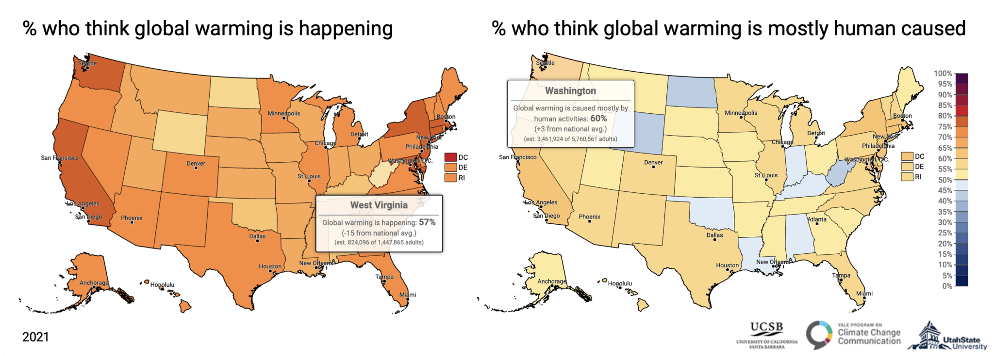
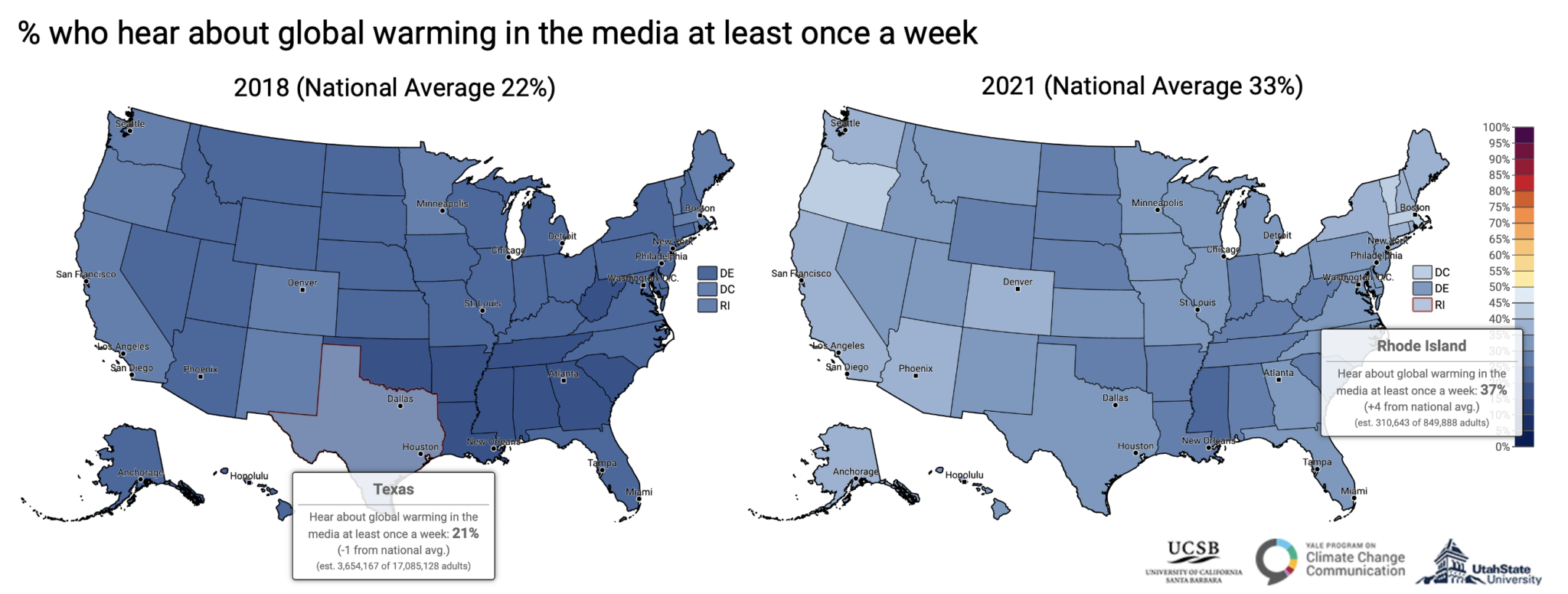
Figure 1. Left: Estimated percentage of residents in each state in 2021 that believes global warming is happening; Right: Estimated percentage of residents in each state in 2021 that says global warming is mostly human-caused.
The YCOM 2021 maps depict geographic variation across 30 measures of climate change beliefs, risk perceptions, policy preferences, and behavior. The new maps show that large majorities in every state think global warming is happening and in most states (42), majorities think global warming is mostly human caused (Fig. 1). Yet, despite the fact that human activities are the dominant cause of global warming, many U.S. residents do not understand this fact.
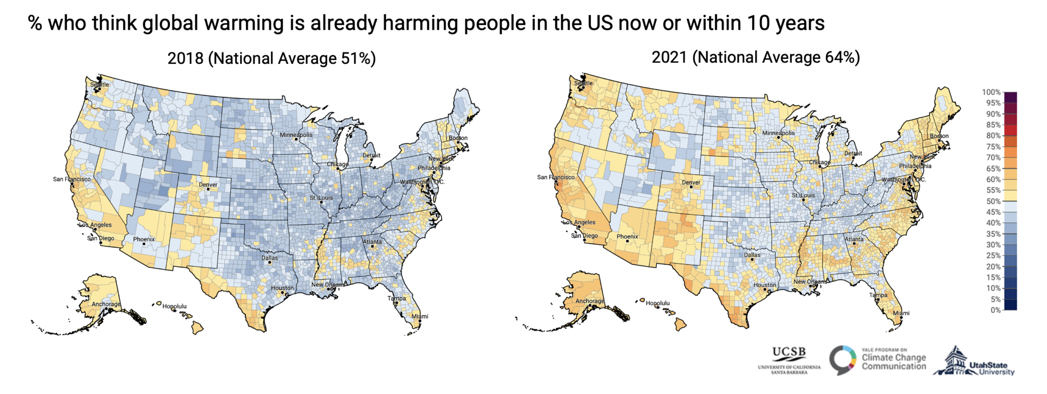
Figure 2. Estimated percentages of U.S. residents that think global warming will harm people in the U.S. within the next 10 years at the county level in 2018 (left) and 2021 (right).
Comparisons between our YCOM 2018 and new YCOM 2021 maps (Fig. 2) illustrate an important shift in national and local climate change beliefs. For example, we find a substantial increase in the number of rural counties with majorities that think that global warming is already harming people in the US now or within the next 10 years, especially across northern states such as Oregon and Montana and along the Atlantic coast, including Florida and South Carolina.
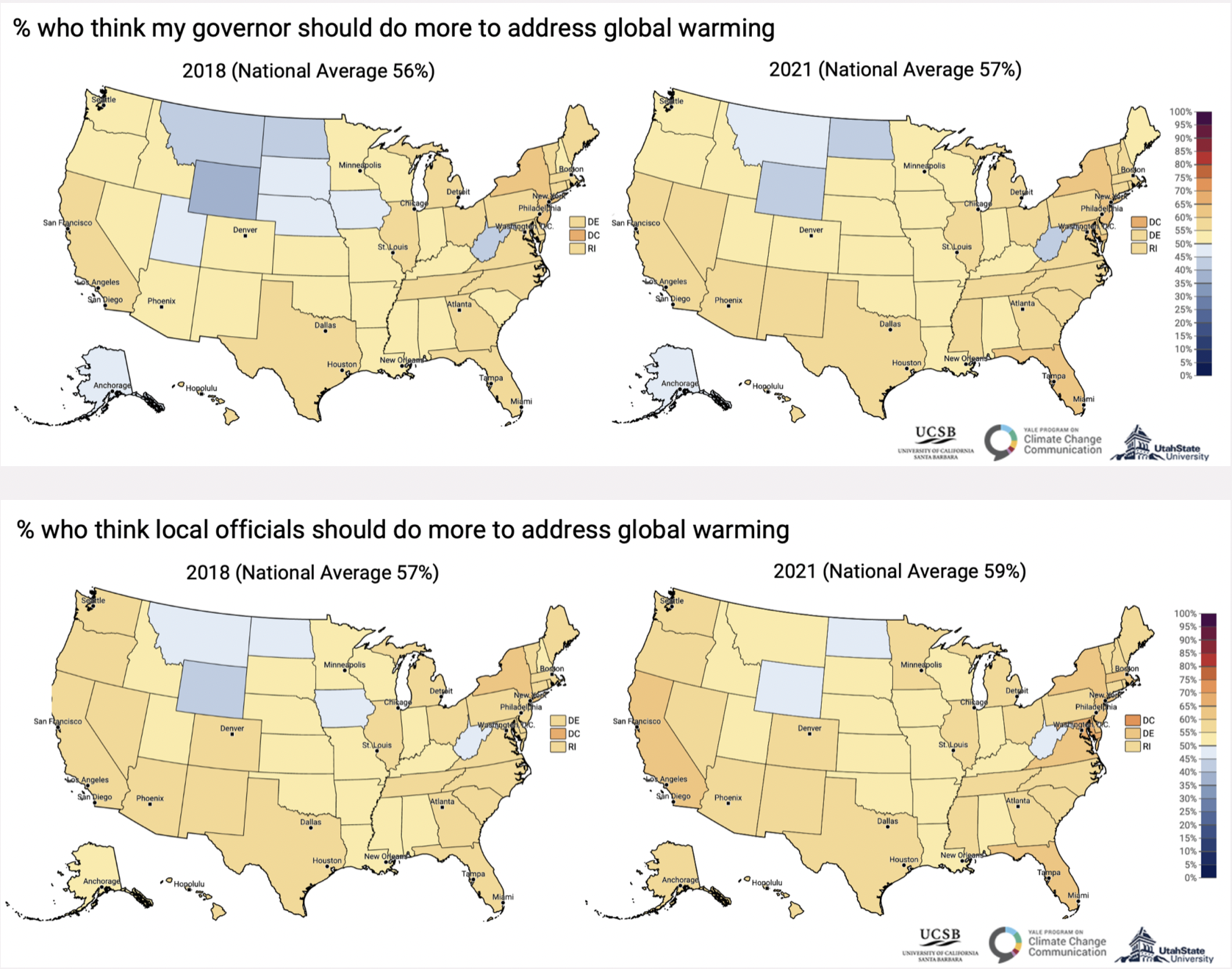
Our surveys have shown that support for climate policy has increased nationally, and the latest maps show where, at the state level, this is occurring. Four new states – Utah, South Dakota, Nebraska, and Iowa – now have majorities that want their own Governors to do more to address global warming (Fig. 3). Increasing incidents of extreme weather in communities across the country, including stronger storms, more uncontrollable wildfires, and more intense heat waves are likely a key factor in these opinion changes, but changes in leadership, political discourse, and media coverage are likely also important factors.
Figure 3. Estimated percentages of U.S. residents that say their own governors (top row) and local officials (bottom row) should do more to address global warming at the state level in 2018 (left) and 2021 (right).Figure 4. Estimated percentages of U.S. residents who have heard about global warming in the media at least once a week at the state level in 2018 (left) and 2021 (right).
Media coverage in particular, has substantially increased over the past four years, moving from a national average of 22% of adults who say they hear about global warming in the media at least once a week in 2018, to 33% in 2021 (Fig. 4). Exposure to climate change media appears to have increased the most in northern states, including Oregon and New York (+14 percentage points), and Idaho, Maine, Vermont, and Washington (+13 pp). More residents of southern states including South Carolina, Georgia, and Tennessee, however, also say they are hearing about it more (+11 pp), since 2018.
We encourage you to visit the interactive maps for more details (2018 maps; 2021 maps)*. As you scroll down the page of the interactive maps you will find bar charts that show results for every question for any geographic location that you select.
We hope these new maps provide helpful context and insight about climate views in the US as you work to engage your own audiences on this vital issue over the coming weeks and months. Please stay tuned for more comprehensive analyses of subnational changes over time in the coming months.
* Please note that while we produced maps in other years for YCOM, the underlying model has changed over time, so we discourage direct comparisons between specific counties and years, but regional differences in the maps between years can reveal broader trends. We are currently in the process of creating robust time series for all years, so please stay tuned for more change-over-time data at subnational scales.
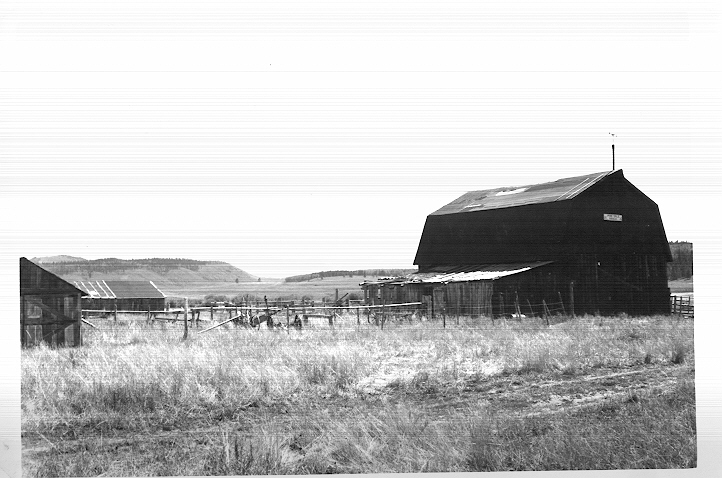
The future site of Steamboat Lake is shown here in 1949. The barn pictured was owned by the Wheeler family, one of several families who ranched the land before it was bought by brothers John and Stanton Fetcher. John Fetcher proposed the construction of Steamboat Lake, which was built in 1967 and funded by the operators of Hayden power station and the Colorado Division of Parks and Outdoor Recreation. Photo via Bill Fetcher and Aspen Journalism
Landowners in Colorado could play a major role in President Joe Biden’s efforts to conserve 30% of the nation’s undeveloped lands by 2030, and make money at the same time.
Jay Fetcher’s family has been ranching cattle since 1994. He said when his family looked into the idea of a conservation easement for their property near Steamboat Springs, his father was immediately sold.
He did not want to see the land developed for the service industry; he wanted it to remain land that produced food…
The family’s decision to conserve the land for ranching caught on, and led to Fetcher founding the Colorado Cattlemen’s Agricultural Land Trust…
Conservation efforts also are seen as critical for protecting clean-water supplies, especially during times of severe drought. Melissa Daruna, executive director of the group Keep it Colorado, said some strategies already under way could provide a path for communities across the West.
The May Ranch near Lamar, Colo., has never been plowed. Photo/Ducks Unlimited via The Mountain Town News
She pointed to local stakeholders on the Eastern Plains outside Pueblo who are taking the lead to reckon with current and future impacts of a warming climate…
In 2008, lawmakers allowed the donated value of the land set aside for conservation to be considered a state tax credit which can be resold to Colorado taxpayers with outstanding tax burdens.
“So all of a sudden, I do an easement, I can sell the value of that easement to a Colorado taxpayer,” said Fetcher. “And I get a check in my pocket. You know, we’re not going to develop the land anyway, but all of a sudden I get paid for not doing it.”
At a time when climate change increasingly threatens water resources across the American West, what can we do to secure a future of sustainability rather than scarcity?
One promising way forward: Look to nature-based solutions from the past.
In the 16th century, long before Europeans settled the continent, the North American beaver was the continent’s most diligent and effective water manager.
Beaver dams – millions of small-scale barriers of twigs, branches and mud – created ponds that acted like giant sponges on the landscape. They stored moisture and created complex wetlands that sustained diverse flora and fauna. They captured sediment and snowmelt that slowed floodwaters and – because they were imperfect and leaky – released water downstream in more even amounts throughout the year.
Then, in a historical instant, beavers were gone from almost every creek and stream – trapped to near extinction to satisfy European trends that prized fur as fashion.
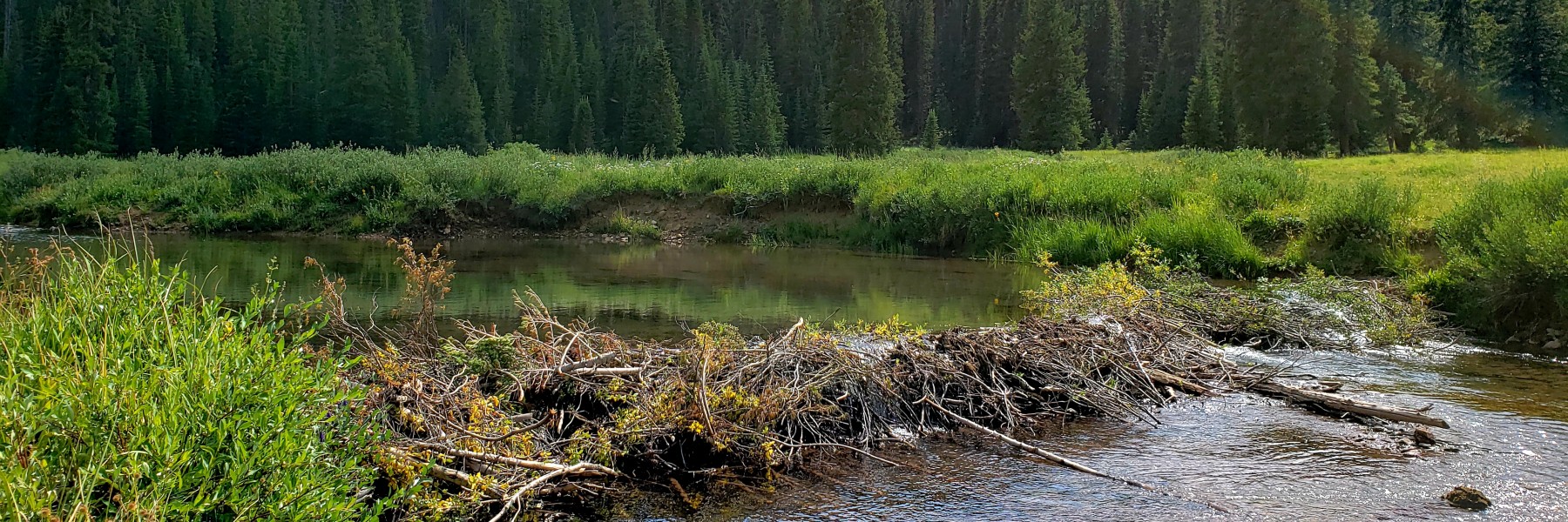
This beaver dam supports willow carr wetlands in Colorado’s North Fork Crystal watershed. These dams can create a virtuous cycle of restoration that revives mountain meadows and stream meanders. Photo Credit: Kyle Jackson
The disappearance of beavers and the natural reservoirs they built created a ripple impact across ecosystems – more erosion in rivers, fewer wetlands, drier landscapes. Many jurisdictions still consider beavers a pest that hinders agricultural productivity.
Today, however, beavers are having a renaissance moment among scientists, conservationists, land managers and some ranchers and farmers.
This keystone species is being rightfully recognized for its ability to restore watery habitat, improve riparian ecosystem health and improve the reliability of water supply – with potential implications for large river systems.
Particularly in dry regions like the Colorado River basin, these rodents can come to the rescue of river systems and are inspiring humans to build beaver-related natural infrastructure.
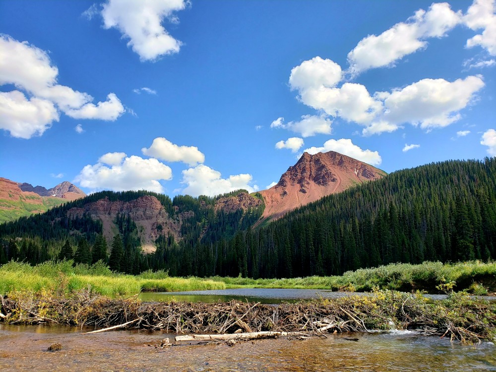
This beaver pond formed upstream of a partially breached beaver dam in the headwaters of Colorado’s Fryingpan River. The photo illustrates how even abandoned dams can support wetland habitat and capture sediment in mountain watersheds. Photo Credit: Sarah Marshall
This illustration by Caroline Nash shows a design for an artificial beaver dam on a degraded stream. Beaver-dam meadows can improve a watershed’s health by trapping snowmelt and releasing water more slowly, increasing available water supply and reducing flooding.
These structures can create a virtuous cycle of restoration that revives mountain meadows and stream meanders, supports wildlife populations, provides natural firebreaks and fire refuge for wildlife and alleviates impacts of post-fire flooding.
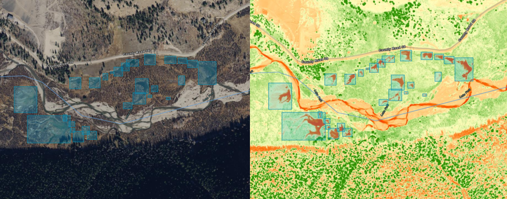
To assess the impact of this work, and its potential to provide system-wide benefit for Colorado River water management, the foundation has initiated an effort to identify and map changes in vegetated wetlands and beaver ponds throughout the basin.
This inactive beaver pond is located along the Crystal River in the Roaring Fork watershed of Colorado. Photo Credit: Sarah Marshall
The first-of-its-kind project, led by Lynker Technologies and the Colorado Natural Heritage Program (CNHP) at Colorado State University, will use remote sensing and machine-learning techniques to map the extent of wetlands and the presence of beaver ponds – and chronicle how they have changed over time.
Scientists will use high-resolution 4-band aerial photography from the National Agriculture Imagery Program (NAIP) and Light Detection and Ranging (LiDAR) remote sensing methods to map wetland extent.
The team has developed deep-learning algorithms to identify and detect beaver ponds from existing historical data, including the U.S. Fish and Wildlife Service’s National Wetlands Inventory.
The mapping team is using a model that searches aerial imagery for characteristic shapes of beaver ponds. The first image, on the left, shows aerial photography from the National Agriculture Imagery Program (NAIP) in “true,” or red/green/blue color. The second image is derived from NAIP imagery and shows an index of wetness that emphasizes the contrast between ponded water and drier areas on river floodplains. Photo Credit: Lynker Technologies
Wetland ecologists from the Colorado Natural Heritage Program, led by Sarah Marshall, will provide training to the mapping team using direct knowledge of the beaver-dam complexes and conduct field surveys to measure map accuracy.
Not only will the maps provide insight into increases or decreases in wetlands over the past decade, but they can also show us ongoing changes including the addition of new wetlands, whether created through beaver-related restoration or beavers themselves.
These beaver ponds in the headwaters of Colorado’s North Thompson Creek, shown in 2021, successfully re-wetted wet meadows that were dry two years earlier. Photo Credit: Sarah Marshall
The mapping data will be released publicly and provide a year-over-year analysis of the impacts of wetlands and beaver-related restoration projects.
The foundation’s support for beaver-related restoration reflects our belief in demonstrating the value of nature-based, nature-friendly solutions that restore ecosystem health and protect water quality and quantity.
At the same time, our investment in this wetlands mapping work is part of a commitment to invest in new technologies that can help the foundation and its partners learn how wetland coverage changes over the next five years.
Photo Credit: Sarah Marshall
We don’t yet know the full potential of beaver-related restoration or whether beavers themselves can mount a comeback, embraced as allies in the fight to protect against climate change.
But their ability to provide free, self-sustaining water infrastructure represents, at a minimum, an opportunity well worth exploring.
American beaver, he was happily sitting back and munching on something. and munching, and munching. By Steve from washington, dc, usa – American Beaver, CC BY-SA 2.0, https://commons.wikimedia.org/w/index.php?curid=3963858
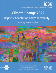
Human-induced climate change is causing dangerous and widespread disruption in nature and affecting the lives of billions of people around the world, despite efforts to reduce the risks. People and ecosystems least able to cope are being hardest hit, said scientists in the latest Intergovernmental Panel on Climate Change (IPCC) report, released today.
“This report is a dire warning about the consequences of inaction,” said Hoesung Lee, Chair of the IPCC. “It shows that climate change is a grave and mounting threat to our wellbeing and a healthy planet. Our actions today will shape how people adapt and nature responds to increasing climate risks.”
The world faces unavoidable multiple climate hazards over the next two decades with global warming of 1.5°C (2.7°F). Even temporarily exceeding this warming level will result in additional severe impacts, some of which will be irreversible. Risks for society will increase, including to infrastructure and low-lying coastal settlements.
The Summary for Policymakers of the IPCC Working Group II report, Climate Change 2022: Impacts, Adaptation and Vulnerability was approved on Sunday, February 27 2022, by 195 member governments of the IPCC, through a virtual approval session that was held over two weeks starting on February 14.
Urgent action required to deal with increasing risks
Increased heatwaves, droughts and floods are already exceeding plants’ and animals’ tolerance thresholds, driving mass mortalities in species such as trees and corals. These weather extremes are occurring simultaneously, causing cascading impacts that are increasingly difficult to manage. They have exposed millions of people to acute food and water insecurity, especially in Africa, Asia, Central and South America, on Small Islands and in the Arctic.
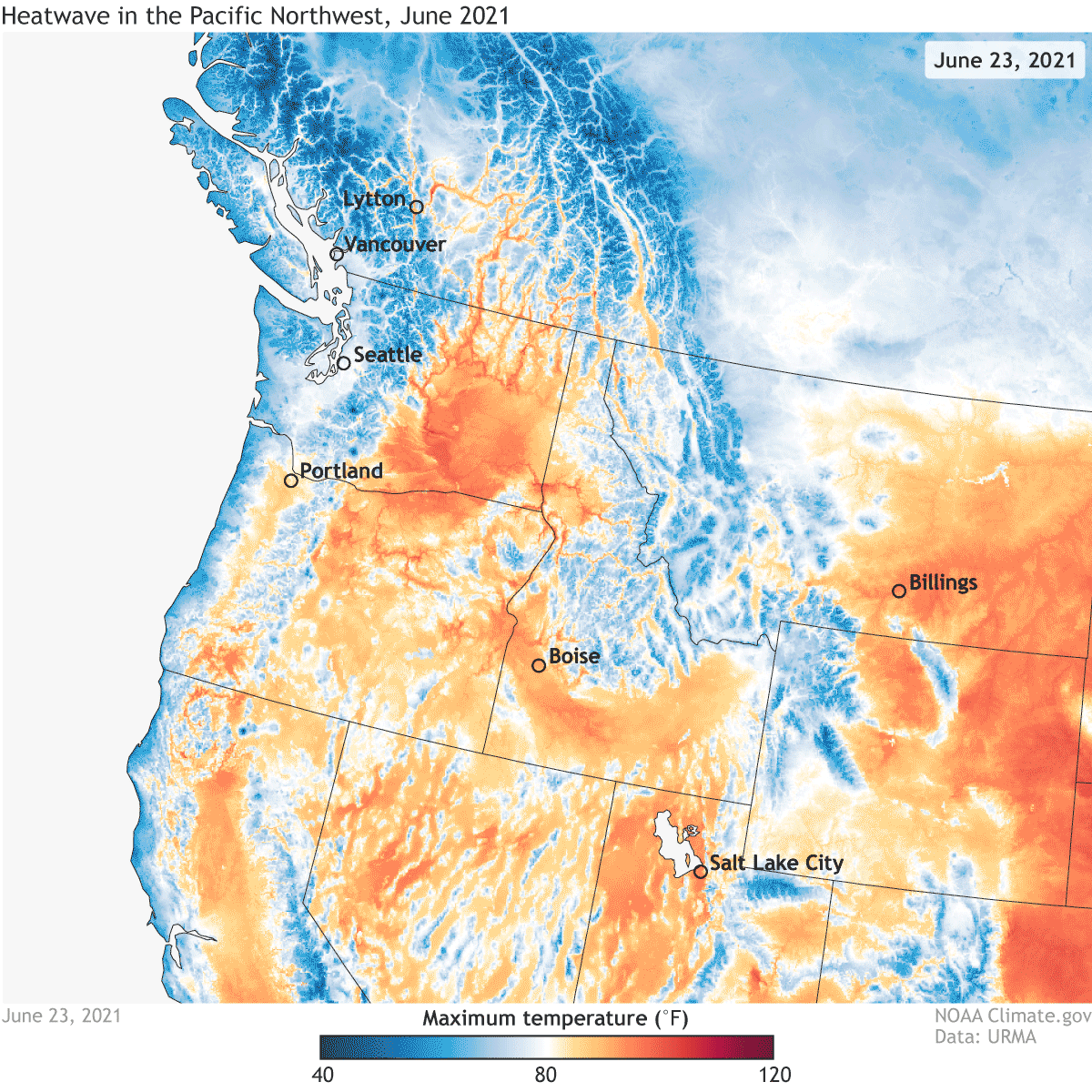
Daytime high temperatures across the western United States on June 23-28, 2021, according to data from NOAA’s Real-Time Mesoscale Analysis/URMA. Climate.gov animation based on NOAA URMA data.
To avoid mounting loss of life, biodiversity and infrastructure, ambitious, accelerated action is required to adapt to climate change, at the same time as making rapid, deep cuts in greenhouse gas emissions. So far, progress on adaptation is uneven and there are increasing gaps between action taken and what is needed to deal with the increasing risks, the new report finds. These gaps are largest among lower-income populations.
The Working Group II report is the second instalment of the IPCC’s Sixth Assessment Report (AR6), which will be completed this year.
“This report recognizes the interdependence of climate, biodiversity and people and integrates natural, social and economic sciences more strongly than earlier IPCC assessments,” said Hoesung Lee. “It emphasizes the urgency of immediate and more ambitious action to address climate risks. Half measures are no longer an option.”
Safeguarding and strengthening nature is key to securing a liveable future
There are options to adapt to a changing climate. This report provides new insights into nature’s potential not only to reduce climate risks but also to improve people’s lives.
A healthy riparian corridor includes native trees and minimal disturbance within 100 feet of the streambank. Waccamaw River photo by Charles Slate.
“Healthy ecosystems are more resilient to climate change and provide life-critical services such as food and clean water”, said IPCC Working Group II Co-Chair Hans-Otto Pörtner. “By restoring degraded ecosystems and effectively and equitably conserving 30 to 50 per cent of Earth’s land, freshwater and ocean habitats, society can benefit from nature’s capacity to absorb and store carbon, and we can accelerate progress towards sustainable development, but adequate finance and political support are essential.”
Scientists point out that climate change interacts with global trends such as unsustainable use of natural resources, growing urbanization, social inequalities, losses and damages from extreme events and a pandemic, jeopardizing future development.
“Our assessment clearly shows that tackling all these different challenges involves everyone – governments, the private sector, civil society – working together to prioritize risk reduction, as well as equity and justice, in decision-making and investment,” said IPCC Working Group II Co-Chair Debra Roberts.
“In this way, different interests, values and world views can be reconciled. By bringing together scientific and technological know-how as well as Indigenous and local knowledge, solutions will be more effective. Failure to achieve climate resilient and sustainable development will result in a sub-optimal future for people and nature.”
Cities: Hotspots of impacts and risks, but also a crucial part of the solution
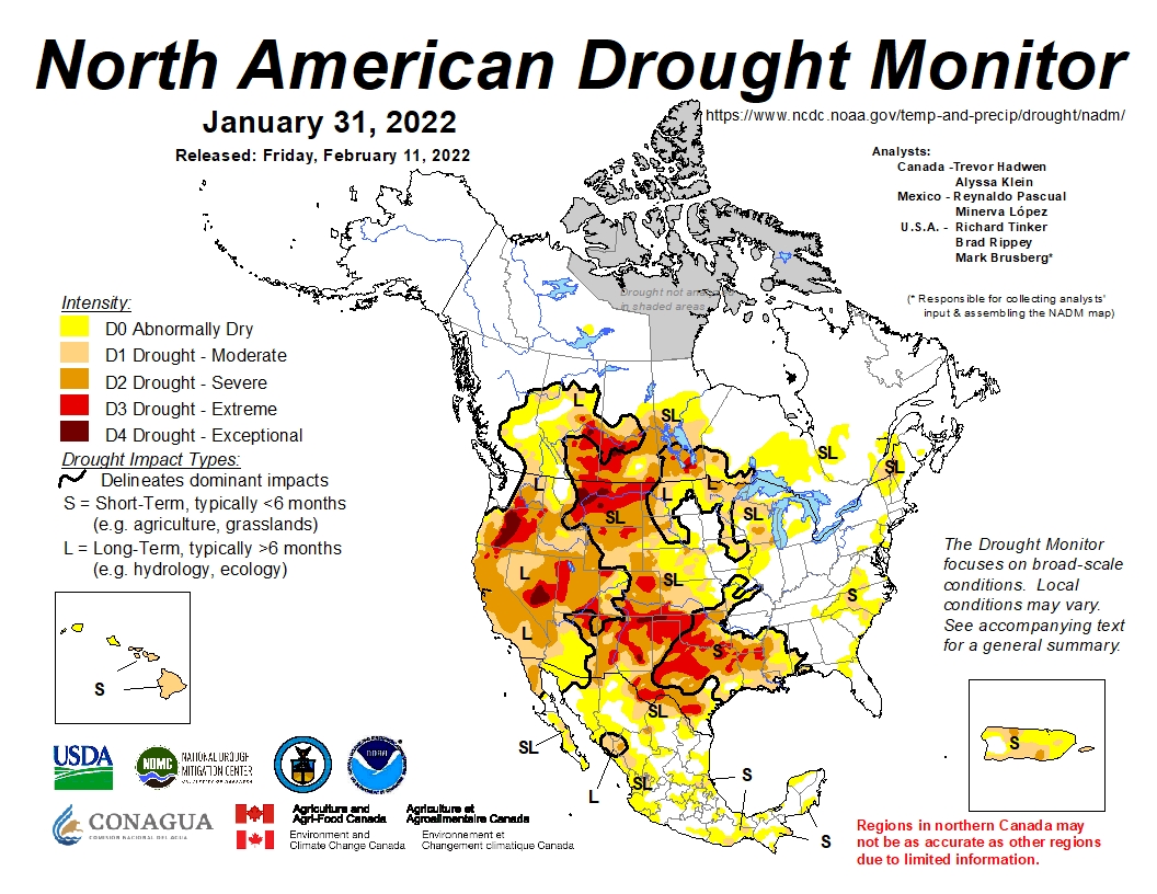
North American Drought Monitor map January 2022
This report provides a detailed assessment of climate change impacts, risks and adaptation in cities, where more than half the world’s population lives. People’s health, lives and livelihoods, as well as property and critical infrastructure, including energy and transportation systems, are being increasingly adversely affected by hazards from heatwaves, storms, drought and flooding as well as slow-onset changes, including sea level rise.
“Together, growing urbanization and climate change create complex risks, especially for those cities that already experience poorly planned urban growth, high levels of poverty and unemployment, and a lack of basic services,” Debra Roberts said.
Water-efficient garden, in Israel. Photo: Paul Andersen/Aspen Journalism
“But cities also provide opportunities for climate action – green buildings, reliable supplies of clean water and renewable energy, and sustainable transport systems that connect urban and rural areas can all lead to a more inclusive, fairer society.”
There is increasing evidence of adaptation that has caused unintended consequences, for example destroying nature, putting peoples’ lives at risk or increasing greenhouse gas emissions. This can be avoided by involving everyone in planning, attention to equity and justice, and drawing on Indigenous and local knowledge.
A narrowing window for action
Denver School Strike for Climate, September 20, 2019.
Climate change is a global challenge that requires local solutions and that’s why the Working Group II contribution to the IPCC’s Sixth Assessment Report (AR6) provides extensive regional information to enable Climate Resilient Development.
The report clearly states Climate Resilient Development is already challenging at current warming levels. It will become more limited if global warming exceeds 1.5°C (2.7°F). In some regions it will be impossible if global warming exceeds 2°C (3.6°F). This key finding underlines the urgency for climate action, focusing on equity and justice. Adequate funding, technology transfer, political commitment and partnership lead to more effective climate change adaptation and emissions reductions.
“The scientific evidence is unequivocal: climate change is a threat to human wellbeing and the health of the planet. Any further delay in concerted global action will miss a brief and rapidly closing window to secure a liveable future,” said Hans-Otto Pörtner.
For more information, please contact:
IPCC Press Office, Email: ipcc-media@wmo.int IPCC Working Group II:
Sina Löschke, Komila Nabiyeva: comms@ipcc-wg2.awi.de
Photo credit: Elisa Stone via the World Weather Attribution
Click the link to read “Humanity has a ‘brief and rapidly closing window’ to avoid a hotter, deadly future, U.N. climate report says: Latest IPCC report details escalating toll — but top scientists say the world still can choose a less catastrophic path” from The Washington Post (Sarah Kaplan and Brady Dennis). Here’s an excerpt:
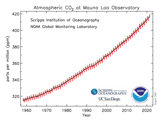
Atmospheric CO2 at Mauna Loa Observatory August 7, 2021.
Unchecked greenhouse gas emissions will raise sea levels several feet, swallowing small island nations and overwhelming even the world’s wealthiest coastal regions. Drought, heat, hunger and disaster may force millions of people from their homes. Coral reefs could vanish, along with a growing number of animal species. Disease-carrying insects would proliferate. Deaths — from malnutrition, extreme heat, pollution — will surge.
These are some of the grim projections detailed by the Intergovernmental Panel on Climate Change, a United Nations body dedicated to providing policymakers with regular assessments of the warming world…
Low-income countries, which generate only a tiny fraction of global emissions, will experience the vast majority of deaths and displacement from the worst-case warming scenarios, the IPCC warns. Yet these nations have the least capacity to adapt — a disparity that extends to even the basic research needed to understand looming risks.
“I have seen many scientific reports in my time, but nothing like this,” U.N. Secretary General António Guterres said in a statement. Noting the litany of devastating impacts that already are unfolding, he described the document as “an atlas of human suffering and a damning indictment of failed climate leadership.”
[…]
Yet if there is a glimmer of hope in the more than 3,500-page report, it is that the world still has a chance to choose a less catastrophic path. While some climate impacts are destined to worsen, the amount that Earth ultimately warms is not yet written in stone.
The report makes clear, however, that averting the worst-case scenarios will require nothing less than transformational change on a global scale.
Denver City Park sunrise
The world will need to overhaul energy systems, redesign cities and revolutionize how humans grow food. Rather than reacting to climate disturbances after they happen, the IPCC says, communities must more aggressively adapt for the changes they know are coming. These investments could save trillions of dollars and millions of lives, but they have so far been in short supply.
The IPCC report is a warning letter to a world on the brink. The urgency and escalating toll of climate change has never been clearer, it says. Humanity can’t afford to wait one more day to take action — otherwise we may miss the “brief and rapidly closing window of opportunity to secure a livable and sustainable future for all.”
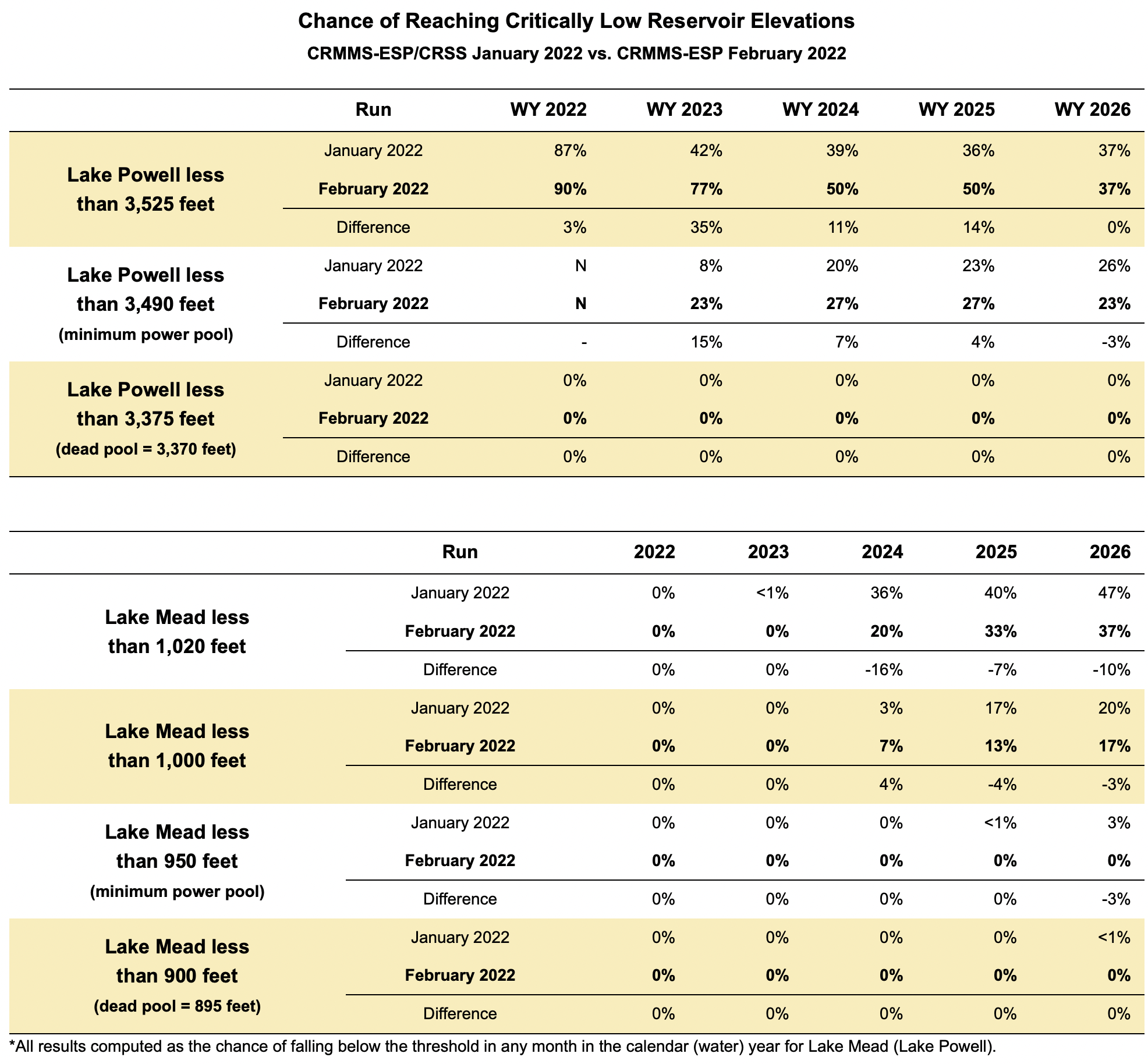
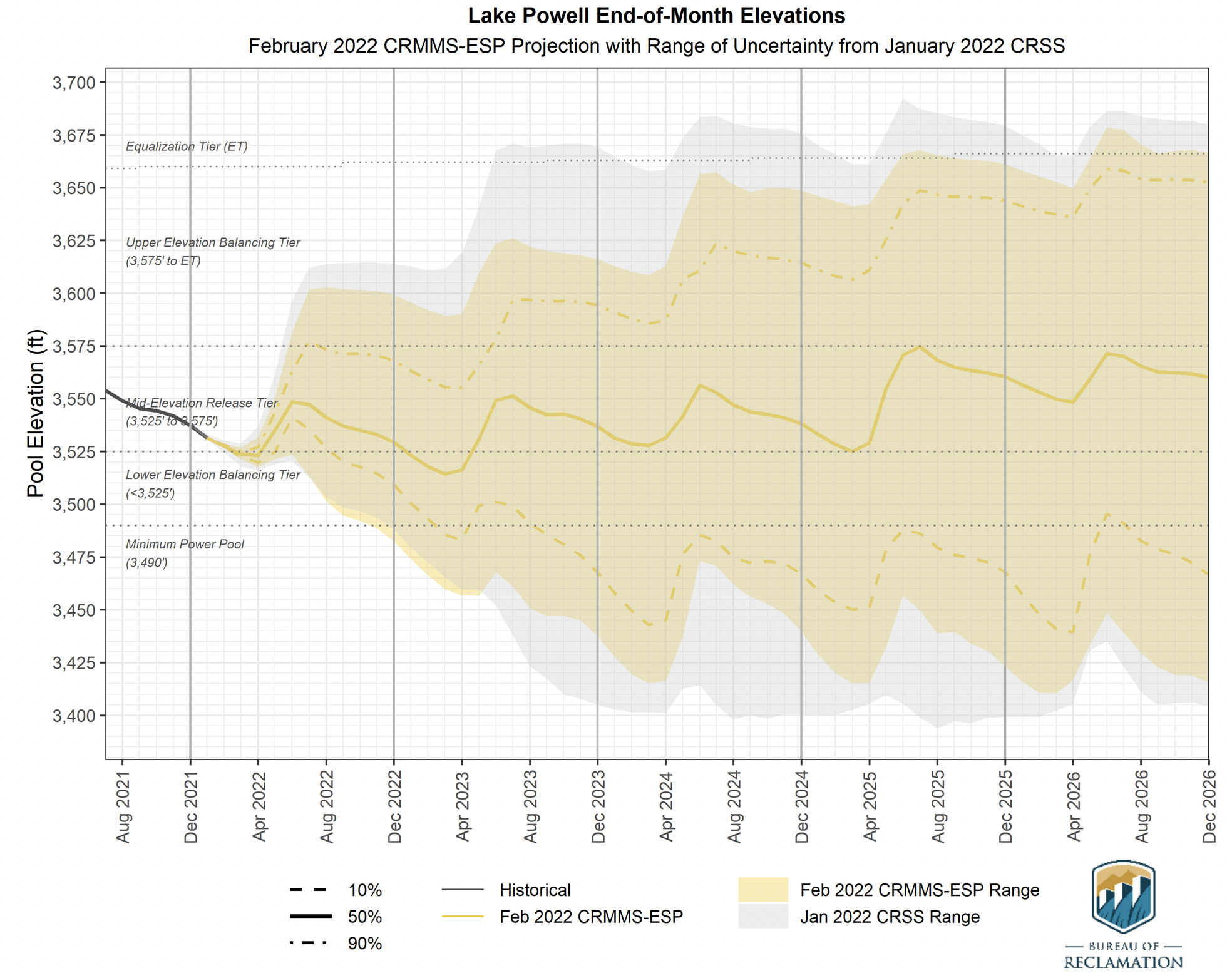
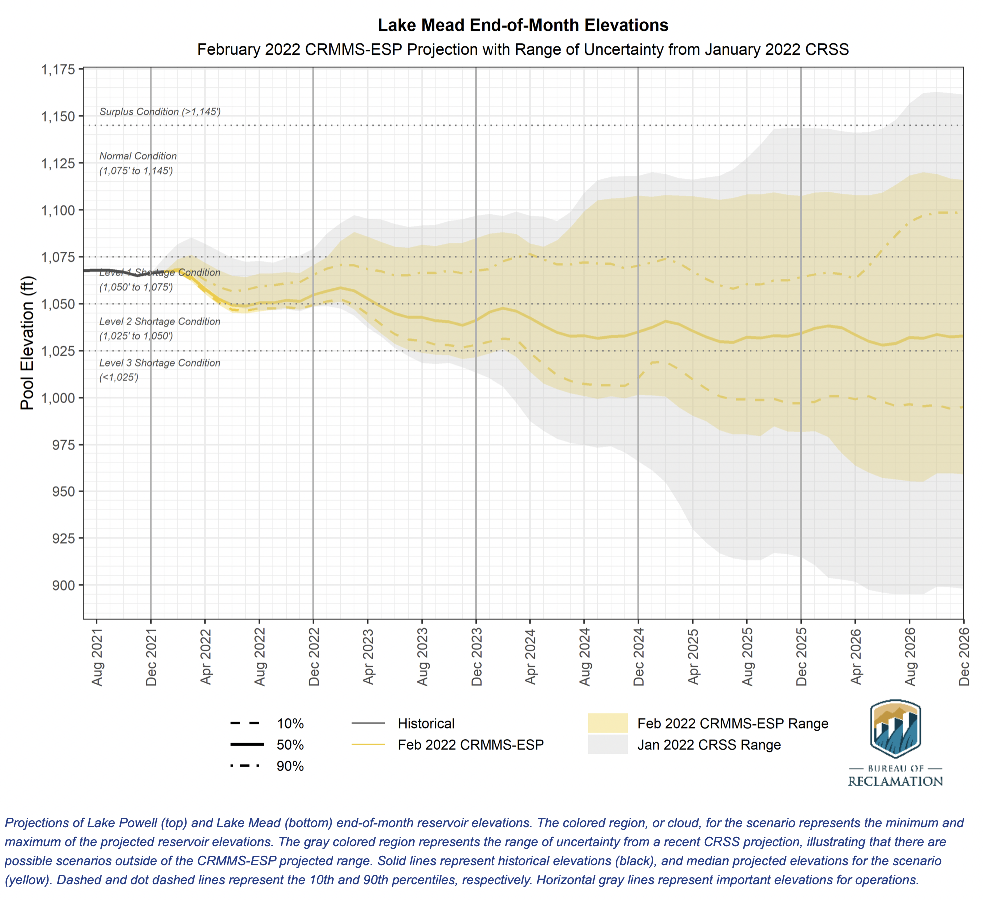
Five-Year Probabilistic Projections of future conditions in the Colorado River system currently extend through 2026. They are typically updated every January, April, and August, while probabilistic results for the 2-year period are updated every month. The 5-Year Probabilistic Projections are generated using the Colorado River Mid-term Modeling System (CRMMS) in Ensemble Mode. CRMMS Ensemble Mode is driven by an ensemble of monthly unregulated streamflow forecasts developed by the National Weather Service Colorado Basin River Forecasting Center (CBRFC) using the Ensemble Streamflow Prediction (ESP) method. Results from CRMMS run with ESP are referred to as CRMMS-ESP.
The most recent 5-year projections of future Colorado River system conditions were produced in February of 2022 using the following assumptions:
Initial Conditions: CRMMS is initialized with previous end-of-month reservoir elevations.
Hydrology: Upper Basin inflows are 30 unregulated inflow forecasts traces produced by the CBRFC using the ESP method, which relies on observed temperature and precipitation from 1991-2020. Lower Basin inflows are the historical intervening flows from 1991-2020 that align with the ESP traces.
Water Demand: Upper Basin demands are estimated and incorporated in the unregulated inflow forecasts provided by the CBRFC; Lower Basin demands are developed in coordination with the Lower Basin States and Mexico.
Policy: 2007 Interim Guidelines, Lower Basin Drought Contingency Plan, and Minute 323 are modeled reflecting Colorado River policies.
Additional details are available in CRMMS Ensemble Mode page. All modeling assumptions and projections are subject to varying degrees of uncertainty. Please refer to this discussion of uncertainty for more information.
Projections
5-Year Probabilistic Projections presented in the tables below are reported as the percentage of projected Lake Powell and Lake Mead operations that fall below critically low elevations or are within each operational tier in the next five years…
The following two figures show a combination of historical and projected reservoir elevations for Lake Powell and Lake Mead.
For additional information or questions, please contact us via email at: ColoradoRiverModeling@usbr.gov.
To be notified when updated projections are available, please email ColoradoRiverModeling@usbr.gov with “Add Me” as the subject.
The passing of ballot measure 7A continues to pay dividends to communities across the fifteen counties of the Colorado River District through the Community Funding Partnership (CFP). The Community Funding Partnership program closed its inaugural year with nearly $3 million distributed to 23 multi-benefit water projects, six of which were fully completed within a year after funding.
“We continue to be humbled by the creativity and resilience of our West Slope water users as they move ideas into action and confront the realities of a hotter and drier future,” said Amy Moyer, Director of Strategic Partnerships at the River District.
Community Funding Partnership grants have also aided recipients in leveraging over $40 million from other funding sources. With the passing of the Infrastructure Investment and Jobs Act in late 2021, even more federal funding will be available for projects which prioritize infrastructure upgrades and water quality. Given these new opportunities and the Community Funding Partnership’s increased notoriety across the District, staff anticipates increased demands and applications in 2022.
“I am glad to see that awareness of this program is growing throughout our district,” said Moyer. “We are looking forward to working with new partners on projects of all scopes in this upcoming year.”
At the recent Special Joint Board meeting on February 9, Moyer presented four new projects to the Board of Directors for funding approval. The approved projects total over $1 million in new grants to start off the CFP program’s second year. A fifth project, which did not require board action, was approved shortly thereafter.
Minturn Storage Tank Project, Town of Minturn
$250,000 awarded, Eagle County
At 25 –years-old, the Town of Minturn’s existing water tank is deteriorating and experiencing active water leaks. This project seeks to upgrade the Town of Minturn’s water infrastructure to address existing water loss rates, increased wildfire risk in the area, and preparations to meet the community’s development demands.
Fruitgrowers Reservoir
Fruitgrowers Dam Outlet Gates Improvement Project, Orchard City Irrigation District
$225,000 awarded, Delta County
The Orchard City Irrigation District (OCID) has partnered with the U.S. Bureau of Reclamation, owners of the Fruitgrowers Reservoir, to plan for upgrades to the reservoir’s control gates. The project modernizes an irrigation dam and reservoir that has been used continuously since 1937, while allowing for more accurate flow monitoring and water releases.
A gaging station in the Yampa River near Maybell has documented 1.5 million acre-feet a century ago to 1.1 million acre-feet now, with one recent year showing only 500,000 acre-feet. Photo/Allen Best
Maybell Diversion and Headgate Modernization Project, The Nature Conservancy
$500,000 awarded, Moffat County
This proposed project involves reconstructing the historic Maybell diversion and modernizing the headgate in the lower Yampa River. The project will improve drought resilience and habitat connectivity in at least 20 miles of the Yampa River, while supporting the recovery of endangered fish and meeting water users’ long-term irrigation needs.
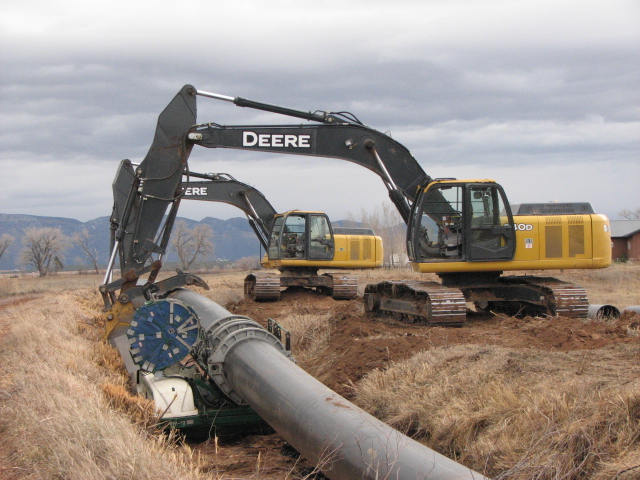
Laying pipe near Crawford, Colorado. Photo credit: USBR
West Slope Growing Water Smart Projects, The Sonoran Institute
$102,000 awarded, District-wide
This project will deliver a Growing Water Smart training and assistance program for five to seven West Slope communities in the fall of 2023. The program aims to catalyze implementation of water conservation measures and the wise use of our water assets through land use planning. The project focuses on strengthening local land-use policies that influence water demand and to support communities as they manage their water resources into the future.
The Schatz Ditch irrigates nearly 70 acres of land south of Silt, according to a ditch inventory by Colorado River Engineering. The ditch is one of 59 inventoried in the Middle Colorado region of western Colorado. CREDIT: HEATHER SACKETT/ASPEN JOURNALISM
Silt Preserve Water Rights and Pond Delivery, Middle Colorado Watershed Council
$8,250 awarded, Garfield County
In 2008, the Aspen Valley Land Trust worked with the Town of Silt and other community partners to purchase and permanently conserve the 132-acre Silt River Preserve. Once heavily grazed and later part of a proposed 2,000‐unit development, this land has the restoration potential to become a natural, riverside park that incorporates innovative agricultural projects. Funds will support restoration opportunities to re-establish high-quality riparian and transitional upland areas.
The Navajo-Gallup Water Supply Project is receiving $123 million from the recent federal infrastructure law to help complete the regional water system.
U.S. Department of the Interior Secretary Deb Haaland announced this week that $1.7 billion from the Bipartisan Infrastructure Law will be used to fulfill settlements for several tribal water rights claims, in addition to funding for the Navajo-Gallup Water Supply Project…
Components of the Navajo-Gallup Water Supply Project remain under construction in northwest New Mexico. When completed, it will deliver San Juan River water to communities on the Navajo Nation and the Jicarilla Apache Nation as well as the city of Gallup…
The $123 million will fully fund four existing construction projects and two new construction contracts that the bureau plans to award this fiscal year…
According to the bureau, the current construction projects are pumping plants in Sheep Springs and in the area of Bahatl’ah and Coyote Canyon chapters, a pipeline from Yah-ta-hey to Tsé Bonito and the segment that will serve Church Rock, Iyanbito, Bááháálí, Chichiltah and Tsé Lichíí chapters.
The amount will also pay for the project’s portion on a new electrical transmission line being built by Western Area Power Authority and Navajo Tribal Utility Authority…
That settlement will bring a regional water system to the Pueblos of Nambe, Pojoaque, San Ildefonso and Tesuque.
Many Indian reservations are located in or near contentious river basins where demand for water outstrips supply. Map courtesy of the Bureau of Reclamation.
Click the link to read the article on Inside Climate News (Katie Surma). Here’s an excerpt:
After just over a year of debate in Panama’s National Assembly, President Laurentino Cortizo signed legislation on Thursday that defines nature as “a unique, indivisible and self-regulating community of living beings, elements and ecosystems interrelated to each other that sustains, contains and reproduces all beings.”
The legislation includes six paragraphs of rights extended to nature, including the “right to exist, persist and regenerate its life cycles,” the “right to conserve its biodiversity,” and the “right to be restored after being affected directly or indirectly by any human activity.”
Panama now joins Bolivia, New Zealand, Bangladesh, Ecuador, Brazil, Colombia and Mexico, among other countries, which have either issued court decisions, enacted laws or amended constitutions recognizing the legal rights of nature. Panama’s law will go into effect one year after it is published in the country’s Official Gazette.
The legislation also imposes new obligations on Panama’s government, including a requirement that its plans, policies and programs respect the rights of nature. It instructs the government to develop manufacturing processes and energy policies that safeguard ecosystems, and it requires the government to promote the rights of nature as part of its foreign policy.
Click the link to read the newsletter at Nine Basins Bulletin. Here’s an excerpt:
This is your new water newsletter.
The Nine Basins Bulletin is the new newsletter from the Southwestern Water Conservation District and the Water Information Program, a summary of the latest updates from southwest Colorado. In this email forum, we want to raise awareness, engagement, and coordination among our nine distinct watersheds—and share our successes with the state. It’s for you.
Send your updates, jobs, and events to lauras@swwcd.org.
What would you like your newsletter to be called? Submit the best newsletter name and win free admission to the seminar and kudos in the next edition…
Southwestern Water Conservation District Awards $197,500 to Local Water Projects
At their February meeting, the Southwestern Water Conservation District Board of Directors approved grants to support the following local water projects:
$60,000 for the Eaklor Ditch Company’s emergency piping project in the Navajo river basin
$28,500 to repair Lone Cone Reservoir’s outlet and intake in the San Miguel river basin
$25,000 toward the Mancos Conservation District’s remote metering program for three historic irrigation ditches
$16,500 to support the Dolores River Restoration Partnership’s ongoing monitoring and stewardship of their tamarisk removal project
$30,000 for the Town of Pagosa Springs’ Yamaguchi South river restoration project on the San Juan river
$16,000 to help Animas Watershed Partnership launch a basin-wide stream management planning process
$5,000 for the Mancos Conservation District’s urban water quality and conservation plan
$16,500 for Science on the Fly’s innovative partnership with anglers to collect water quality data in the San Miguel, Animas and La Plata basins
Colorado State Capitol. Photo credit: Allen Best/Big Pivots
Click the link to read the article on Big Pivots (Allen Best):
A bill proposing study of nuclear energy in Colorado was killed in an obscure legislative committee last week by the majority Democrats.
This debate isn’t over, though, nor will it be until we’ve learned how to store our bounty of renewable energy for weeks or even months.
We have made huge strides since voters in 2004 mandated Colorado’s largest utilities achieve 10% of their generation from renewables by 2015. Xcel Energy now expects to achieve 86% penetration of renewables by 2030. Nearly all other utilities, large and small, expect to be close behind, or like the Glenwood Springs-based Holy Cross Energy, further ahead.
Sharing of renewables across broad, multi-state areas will be imperative. Smaller, incremental approaches will help. For example, new programs will help us run our dishwashers and charge our electric cars when renewable energy is most abundant.
This gets utilities to maybe 90% emissions-free electricity without imperiling reliability or jacking up costs. It’s that last 10% that perplexes.
Possible paths include molten-salt storage. Xcel Energy considers this an option at Hayden, in northwestern Colorado, when it closes those coal units by 2028. Tri-State, operator of the three coal units at Craig, has indicated an openness to all options, including green hydrogen, which is made from renewable electricity and water in a still-expensive process. Some hope for improved batteries.
Divide West Unaweep Canyon. Photo credit: Atlas Obscura
Another answer may be pumped-storage hydro, as Xcel has been thinking about in Unaweep Canyon, in western Colorado. Others have similar hydro thoughts for the Yampa Valley.
State Sen. Bob Rankin, a Republican from Carbondale, represents Craig and Hayden. An electrical engineer by training, Rankin had a career in technology, including a stint managing the aerospace division of Ford Motors. He pitched nuclear energy last week to members of the Senate State, Veterans and Military Affairs Committee as necessary for Colorado to meet its decarbonization goals.
That a Republican representing coal country accepts that coal is not coming back is itself noteworthy. In Wyoming, many have not.
The second major component of the bill was the most telling. Rankin initially wanted Colorado’s economic development agency to commission the $500,000 study (pared to $250,000 before the vote). The Colorado Energy Office, the more obvious choice, was too strictly focused on wind and solar, he said.
That’s not entirely accurate. Wind and solar have been major successes, but just weeks before, the energy office released a study about the legal framework Colorado needs for carbon capture and storage. Carbon capture would allow continued burning of natural gas—a possible way to get to 100%—or, for that matter, burning of coal.
Rankin was absolutely on target in describing nuclear power as being a way to make use of existing infrastructure, both the coal plant sites at Hayden and Craig and transmission. Nuclear could also produce jobs and tax base for those communities. Just as 100% emissions-free energy (at an affordable price) remains elusive, so do the answers for Craig’s economy once the coal plants close. For the same reasons, commissioners in Pueblo County last summer quietly began pushing the idea of nuclear energy.
Cost is the conversational crux of nuclear. The technology has a history of high costs for construction. A new generation of small, modular reactors, if done in many places, may be more economical. One such reactor backed financially by Bill Gates is proposed for a Wyoming coal town, but it’s years from breaking ground. It may be the future—but it’s a big gamble.
Atmospheric CO2 at Mauna Loa Observatory August 7, 2021.
Climate change is an even larger, more costly gamble. That’s one reason nuclear power does not fall neatly along a Republican/Democratic divide. One person who testified in support of Rankin’s bill identified himself as a card-carrying Democratic activist.
Democrats were unpersuaded, even after Rankin moved the study to the energy office. He never explained exactly what answers this study would have delivered that couldn’t be found elsewhere. The bill seemed more intent on making a political statement than delivering useful information. But then Democratic legislative leaders had made a statement themselves by not assigning the bill to the energy committee.
Had the bill advanced, we would have heard from State Sen. Chris Hansen, a Democrat and a key architect of Colorado’s energy transition. Growing up in a Kansas farm town, Hansen became enamored of nuclear energy. Even as he earned a bachelor’s degree in nuclear engineering, though, he pivoted his studies to economics, capping it with a Ph.D. The economics of nuclear energy, he told me last June, is why he believes the technology won’t be a major answer to the climate emergency.
Until we get to 100% renewables, though, it’s likely to be on the table.
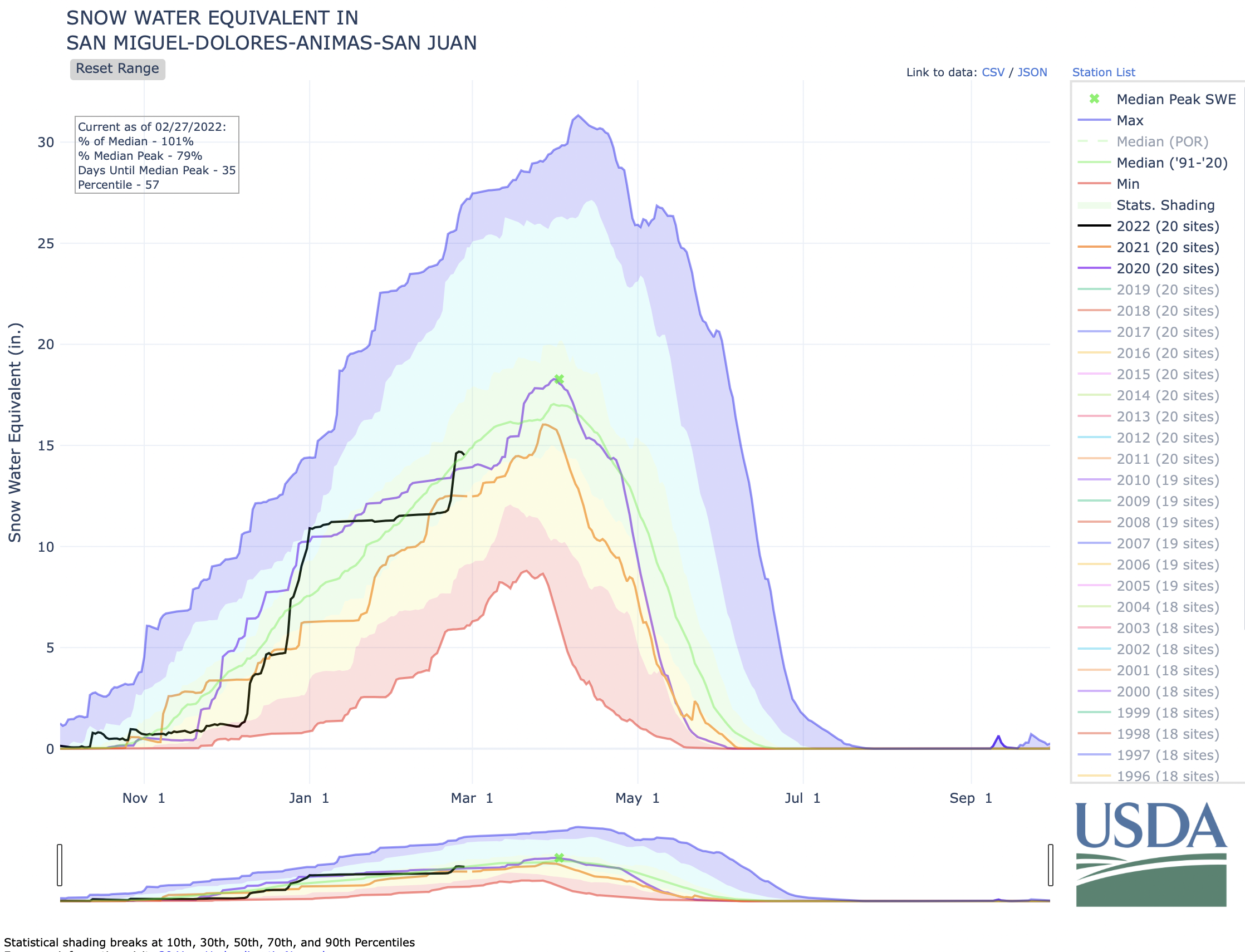
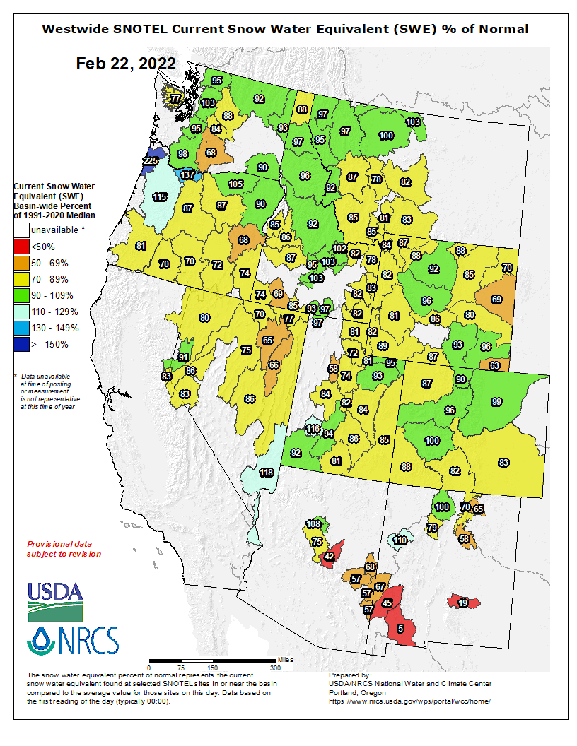
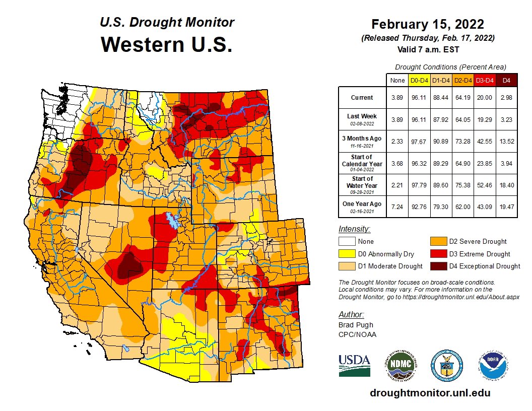
Wolf Creek Ski Area reported 17 inches of fresh snowfall on Tuesday afternoon and 25 inches from the storm as of 6 a.m. Wednesday…According to the U.S. Depart- ment of Agriculture (USDA) National Water and Climate Center’s snow pack report, the Wolf Creek summit, at 11,000 feet of eleva- tion, had 25.9 inches of snow water equivalent as of 10 p.m. on Tuesday, Feb. 22. The Wolf Creek summit was at 113 percent of the Feb. 22 snow- pack median. The San Miguel, Dolores, Ani- mas and San Juan river basins were at 88 percent of the Feb. 22 median in terms of snow pack.
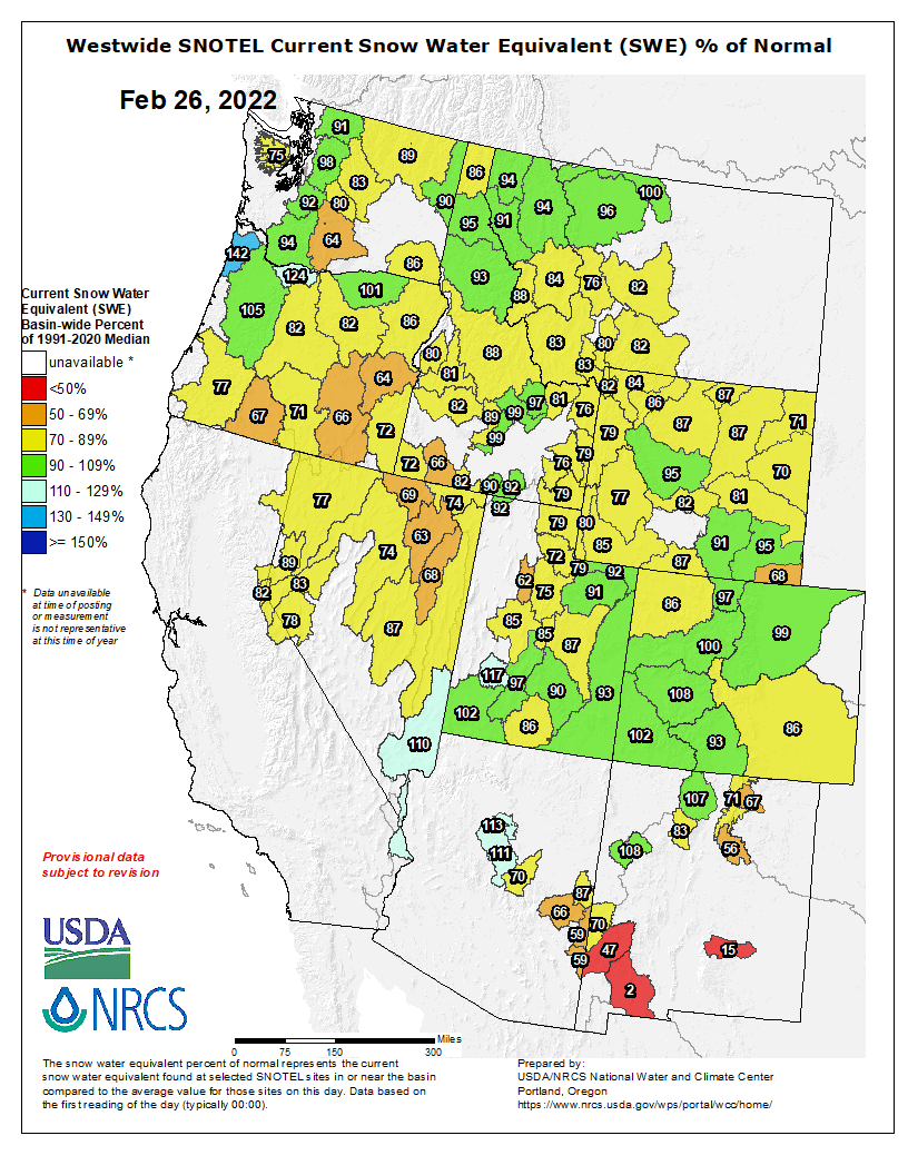
Westwide SNOTEL basin-filled map February 26, 2022 via the NRCS.
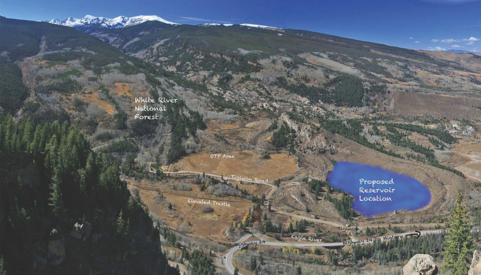
The San Juan Water Conservancy District (SJWCD) Board of Directors discussed future water supplies and housing in Archuleta County at its February 21, 2022 meeting. During a discussion on hiring a consultant for water demand analysis, the board considered the broader question of the future water needs of Archuleta County. This discussion focused on the construction and design of SJWCD’s Dry Gulch Reservoir project, a proposed reservoir to provide additional water to the area.
Questions emerged, however, about what size of reservoir would be needed to satisfy Archuleta County’s demands for water and when such a reservoir might be needed. The directors agreed that COVID has caused a large spike in population growth over the last two years. However, there were differing opinions on whether this growth would continue and how rapidly it would occur. According to the directors, the statistics on growth, in turn, would impact the water demands of the county. If these water demands were sufficiently large, they would necessitate the construction of the Dry Gulch Reservoir, which the board agreed is currently unnec- essary to meet Archuleta County’s present water needs.
A canal to bring in water from Colorado and a large lake between Omaha and Lincoln both inched one step closer to reality Friday, but both proposals remain awash in questions.
Gov. Pete Ricketts has backed the water-related initiatives. Lawmakers on the Legislature’s Natural Resources Committee voted to advance bills laying the groundwork for each of them on Friday, and the Appropriations Committee approved a fraction of the $500 million the governor requested to fund the canal project.
Legislative Bill 1015 would give the Department of Natural Resources the authority to build and maintain a canal and reservoir system to divert water from the South Platte River in Colorado for use in Nebraska. Under a compact that’s nearly a century old, the canal would allow the state to claim up to 500 cubic feet per second of water for irrigation between Oct. 15 and April 1.
The South Platte River Basin is shaded in yellow. Source: Tom Cech, One World One Water Center, Metropolitan State University of Denver.
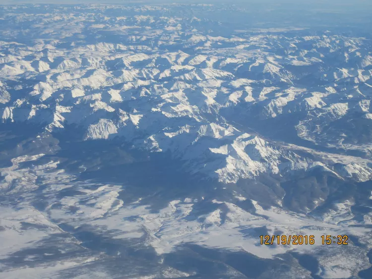
San Juan Mountains December 19, 2016. Photo credit: Allen Best
From email from Reclamation (Susan Novak Behery):
In response to decreasing flows in the critical habitat reach, the Bureau of Reclamation has scheduled an increase in the release from Navajo Dam from 350 cubic feet per second (cfs) to 400 cfs for tomorrow, Saturday, February 26th, at 4:00 AM.
Releases are made for the authorized purposes of the Navajo Unit, and to attempt to maintain a target base flow through the endangered fish critical habitat reach of the San Juan River (Farmington to Lake Powell). This release change is calculated as the minimum required to maintain the target baseflow.
The San Juan River Basin Recovery Implementation Program recommends a target base flow of between 500 cfs and 1,000 cfs through the critical habitat area. The target base flow is calculated as the weekly average of gaged flows throughout the critical habitat area from Farmington to Lake Powell.
This scheduled release change is subject to changes in river flows and weather conditions. If you have any questions, please contact Susan Behery (sbehery@usbr.gov or 970-385-6560), or visit Reclamation’s Navajo Dam website at https://www.usbr.gov/uc/water/crsp/cs/nvd.html
Click the link to read the article on the NOAA website (Kai-Chih Tseng and Nat Johnson):
Guest co-author Dr. Kai-Chih Tseng is a postdoctoral research scientist at Princeton University and the NOAA Geophysical Fluid Dynamics Laboratory who is an expert on climate variability and prediction, including the study of atmospheric rivers. In the summer of 2022, Dr. Tseng will begin an assistant professor position in the Department of Atmospheric Science at National Taiwan University.
This past December, a mind-boggling 18 feet of snowfall fell in the California Sierra Nevada Mountains! How does so much snow fall in one place in such a short period of time? One of the primary phenomena responsible for such extreme rain and snowfall, particularly in regions like the western U.S., is the atmospheric river. Like their terrestrial counterparts, atmospheric rivers carry tremendous amounts of water over thousands of miles. These aerial versions, however, often bring both severe disruption and great benefit through the heavy rain and mountain snows that they produce. In this blog post, we will give you a brief primer on atmospheric rivers and (of course!) explain how they are affected by ENSO (El Niño-Southern Oscillation).
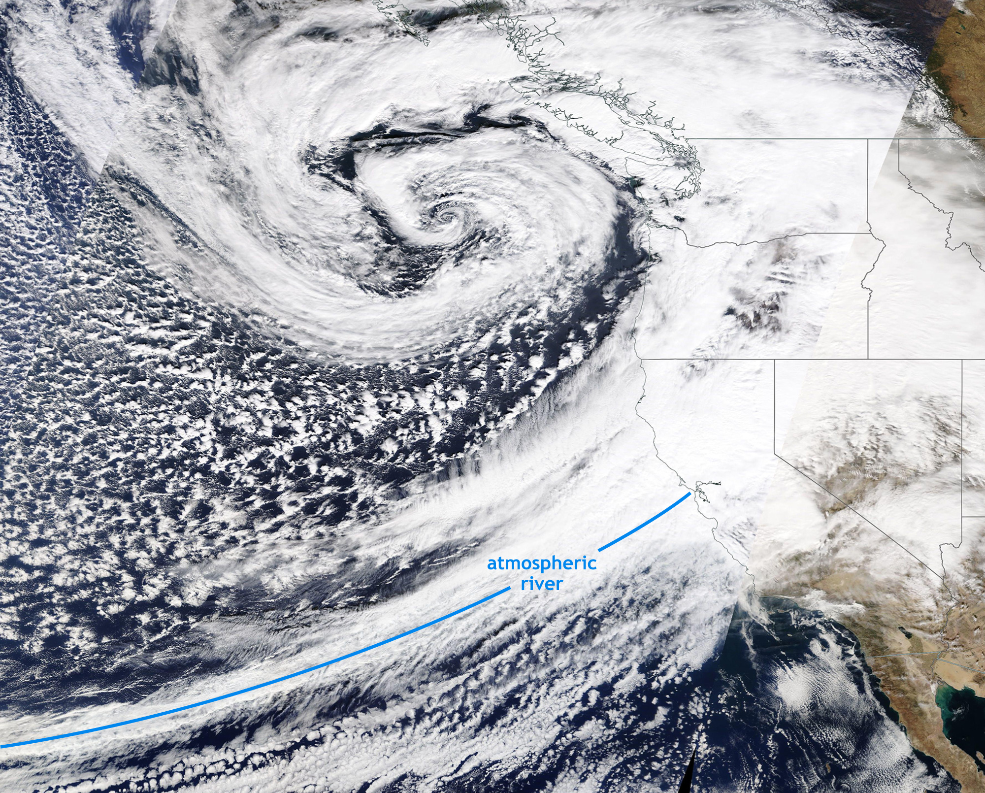
Flying Mississippis
Satellite image taken on October 24, 2021. A powerful storm off the Pacific Northwest coast brought an intense atmospheric river to the San Francisco Bay region of California. NASA MODIS/TERRA satellite image taken from NASA Worldview.
Atmospheric rivers are long, narrow corridors of moisture-laden air extending from the tropics to higher latitudes. They can produce heavy rain and snowfall in short periods of time, especially when the air is lifted over high terrain, cooling the air and condensing the moisture into droplets, like wringing out an atmospheric sponge. When you see these impressively long features on satellite imagery, it’s no wonder that they are compared to rivers. In fact, an average atmospheric river carries 25 times the amount of water as the Mississippi River!
They form when warm, moist air in lower latitudes is transported poleward like a conveyor belt ahead of a trailing cold front from a powerful mid-latitude storm. Around the globe, atmospheric rivers are responsible for more than 90% of the water vapor that is transported to the mid-latitudes from the tropics and are a critical source of water for many regions, such as California and Nevada. They also can be quite destructive, causing severe flooding and damaging winds, with the strongest atmospheric rivers in the western U.S. typically causing damages in the hundreds of millions of dollars (1).
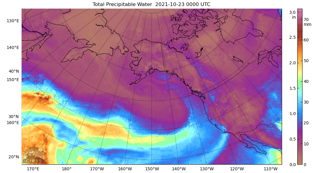
Click the image to render an animation of the atmospheric river hitting the U.S. west coast on October 23, 2021. Credi: NOAA
Several notable atmospheric rivers have made landfall along the West Coast of the U.S. this past fall and winter. On October 24-25, 2021, an intense atmospheric river brought high winds and historic rain reaching up to a foot to the San Francisco Bay region, providing a temporary reprieve from an enduring drought (but clearly not enough to end it). The animation above (2) shows the narrow, river-like corridor of concentrated water vapor that resulted in this historic rainfall. California is no stranger to this “boom or bust” precipitation pattern. Incredibly, up to half of the annual precipitation in parts of California falls in just 5 to 10 wet days during the year (is it any wonder that seasonal prediction of precipitation is so hard?), and atmospheric rivers are a major source of those few wet days (3). California is unique in terms of such extreme precipitation variability, but other western states, like Washington and Oregon, also rely on atmospheric rivers for water supply.
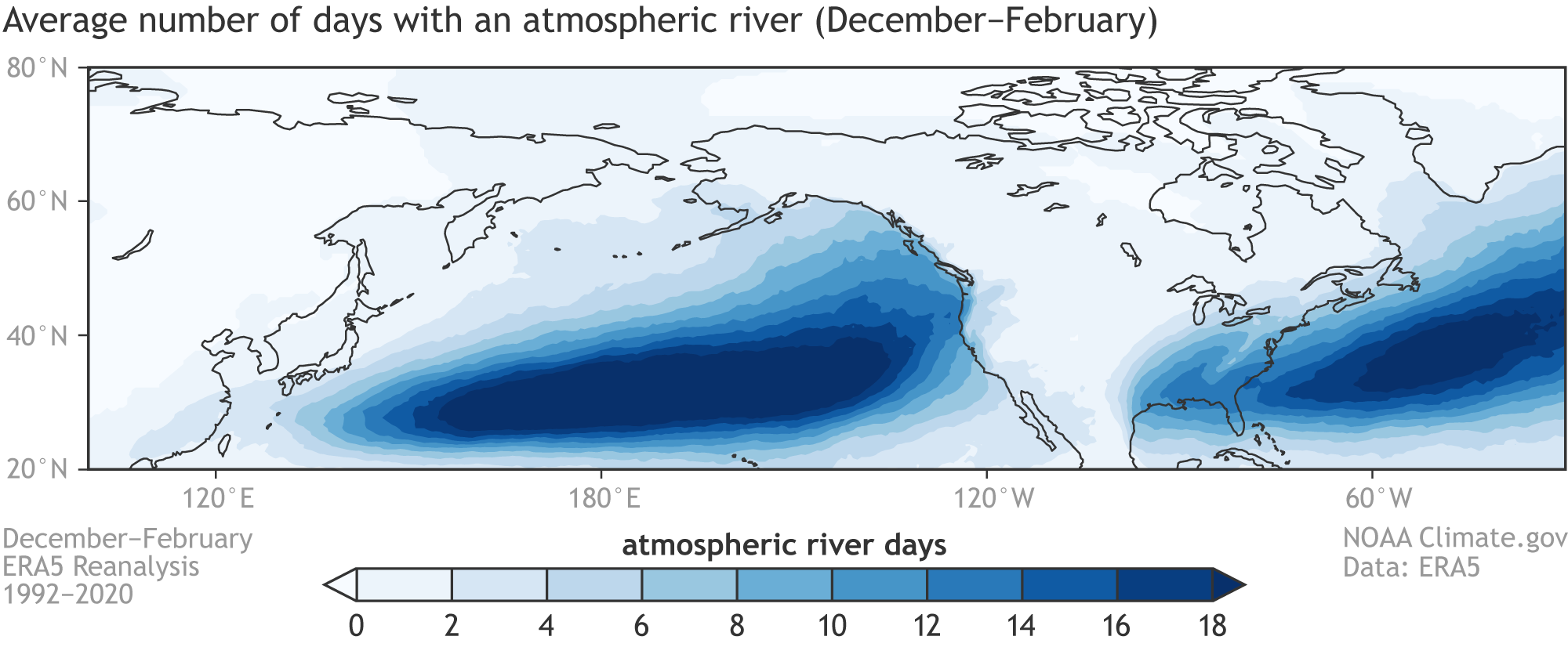
So, where and how often?
Average number of days each winter (December–February) with an atmospheric river occurrence over the northeastern Pacific Ocean. Maps calculated with ERA5 Reanalysis data covering the 1992-2020 period and with the Mundhenk et al. (2016) method for detecting atmospheric rivers.
Atmospheric rivers (see footnote 4 for how we define them) occur throughout much of the globe outside of the tropics and in all seasons, but they are most frequent in the storm tracks in the vicinity of jet streams. Their impacts on the U.S. are most pronounced in winter. The figure above shows that in a typical December–February period, atmospheric rivers near North America occur most often offshore in the North Pacific and North Atlantic. Although their importance is emphasized in the western U.S. because of their large contribution to annual rain and snow totals, they also frequently occur in central and eastern U.S. states, where we can expect approximately 10 winter days each year with an atmospheric river occurrence.
This is the ENSO Blog!
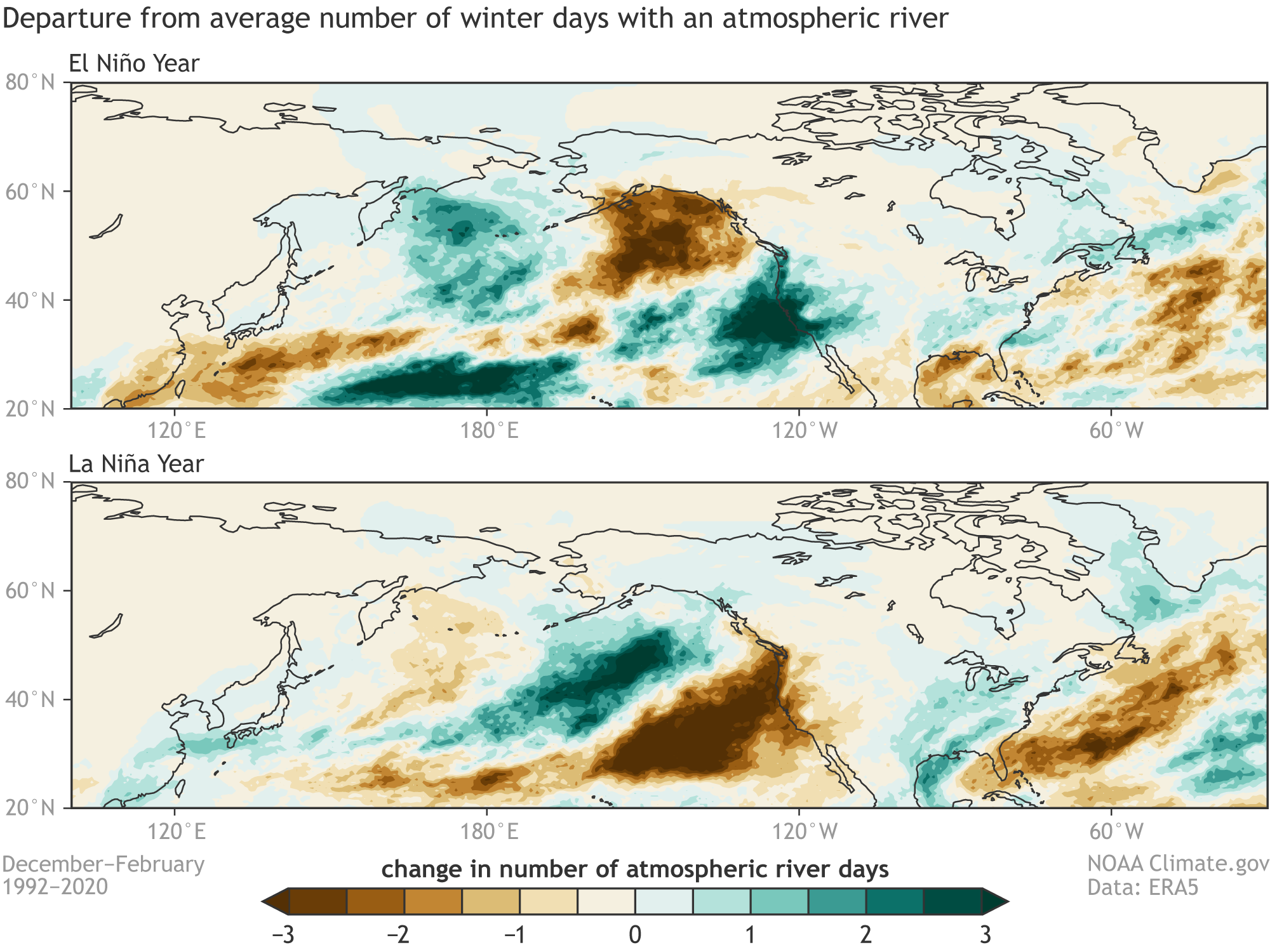
Don’t worry, we didn’t forget about the role of ENSO! Just as ENSO impacts the seasonal temperature and precipitation patterns over North America, it also affects the frequency of landfalling atmospheric rivers. Over the past 30 years, El Niño has brought more frequent than normal West Coast landfalling atmospheric rivers, whereas La Niña generally has brought less frequent occurrences. This winter has been pretty consistent with typical La Niña conditions, with below-average western U.S. atmospheric river activity. Despite a two-week period in December that brought atmospheric rivers and record snow to California, January was the second driest on record in California and Nevada.
Departures from the average number of days each winter (December–February) with an atmospheric river occurrence for (top) El Niño and (bottom) La Niña from 1992-2020. During El Niño winters, the number of days with atmospheric rivers is below average along the Alaska and western Canada coastlines, but above average along the U.S. West Coast. La Niña tends to bring the opposite: fewer atmospheric river days along the U.S.West Coast.
But how well can we predict atmospheric rivers?
As with all extreme precipitation events, accurate forecasts of individual atmospheric rivers and their impacts are limited to short-range weather forecasts. However, the latest research efforts are advancing our ability to predict regional atmospheric river activity (not individual storms) on subseasonal (roughly 2-4 weeks in advance) and even seasonal time horizons. On subseasonal timescales (5), the sources of atmospheric river predictability are rooted in large-scale climate patterns such as the Madden-Julian Oscillation and the Pacific-North American Pattern. On the seasonal side, a recent study led by guest co-author Dr. Kai-Chih Tseng indicates that one of the models participating in the North American Multi-Model Ensemble (NMME), SPEAR, can produce skillful seasonal forecasts of atmospheric river activity over some regions, including coastal California and Alaska, up to nine months in advance. The guiding hand of ENSO is one of the main reasons that seasonal atmospheric river forecasts may be possible.
Effects of climate change
Human-caused climate change is likely to increase atmospheric river intensity. Warming oceans lead to increasing available moisture for these powerful storms, enhancing the moisture transport and heavy precipitation that they produce. While several global climate model studies support the increasing intensity of atmospheric rivers with global warming, additional study is needed to better understand how other atmospheric river properties, like size, shape, frequency, and location, will change.
The bottom line is that any increase in atmospheric river intensity will contribute to the growing water resource challenges in the western U.S. Therefore, we can expect that improving our understanding and our ability to predict atmospheric rivers across a range of timescales will remain a major scientific priority.
Footnotes
1. For more information on how destructive atmospheric rivers can be for the western U.S., we recommend this article. Corringham et al. (2019) use a scale that divides atmospheric rivers into 5 intensity categories, like what we do for hurricanes and tornadoes.
Corringham, T. W., Ralph, F. M., Gershunov, A., Cayan, D. R., & Talbot, C. A. (2019). Atmospheric rivers drive flood damages in the western United States. Science Advances, 5(12), eaax4631. https://doi.org/10.1126/sciadv.aax4631
2. Hat tip to our friends at the Seasoned Chaos blog for providing the tools to construct this animation. Please check out their awesome complementary post on atmospheric rivers.
3. For additional information on the link between atmospheric rivers and California’s water resources, we recommend this article.
Dettinger, M.D., Ralph, F. M., Das, T., Neiman, P.J., & Cayan, D. R. (2011). Atmospheric rivers, floods and the water resources of California. Water, 3(2), 445–478. https://doi.org/10.3390/w3020445
4. At this point, you may be saying, “Wait, Nat and Kai-Chih, how do I know if an atmospheric river is occurring?” Good question! There is no single, objective method to identify atmospheric rivers, but there are several algorithms that are commonly used. All these algorithms share at least two features in common: (1) atmospheric vapor transport must be unusually strong, and (2) the vapor transport must be concentrated in a feature that is long and narrow. In the analysis of this blog post, we analyze daily fields of vertically summed water vapor transport and use the method of Mundhenk et al. (2016) to identify grid cells where an atmospheric river is occurring. The Mundhenk et al. (2016) method ensures that the two criteria listed above are met.
5. For example, check out some of the neat experimental subseasonal atmospheric river forecast products provided by the Center for Western Weather and Water Extremes (CW3E) at this site.
Governor Mark Gordon has announced the appointment of Brandon Gebhart as Wyoming State Engineer. Gebhart was appointed interim State Engineer in December and previously served as the Director of the Wyoming Water Development Office.
Wyoming river basin map. Credit: The Wyoming Geological Survey
The State Engineer serves as the chief water official in the state and is responsible for the general supervision of Wyoming’s waters, including technical, policy and regulatory matters concerning its beneficial use.
Gebhart is a native of Wheatland, Wyoming and has spent more than 20 years in consulting engineering, primarily working in the field of water resources. He earned a Civil Engineering degree from the University of Wyoming and is a licensed Professional Engineer.
“Brandon is the right person for this job: he has an outstanding technical background in water resources and civil engineering; a firsthand understanding of Wyoming water issues; and brings a can-do attitude that supports the needs of Wyoming’s water users,” Governor Gordon said. “In this day and age, to serve as Wyoming State Engineer requires a unique set of skills. I am proud to welcome Brandon to lead the way and protect Wyoming’s water interests.”
“It is an honor to be asked to serve as the State Engineer,” Gebhart said. “These are very interesting times and I am excited to be a part of helping Wyoming continue to use and develop our water resources.”
Gebhart’s appointment is subject to confirmation by the Wyoming Senate, with a term that runs through February 28, 2023.
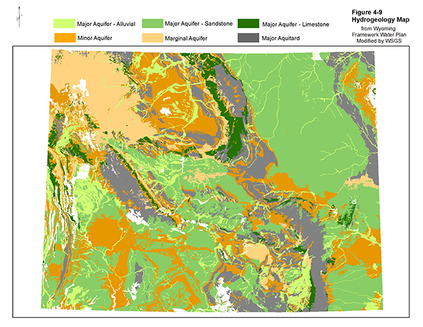
Wyoming hydro-geological map. Credit: The Wyoming Geological Survey
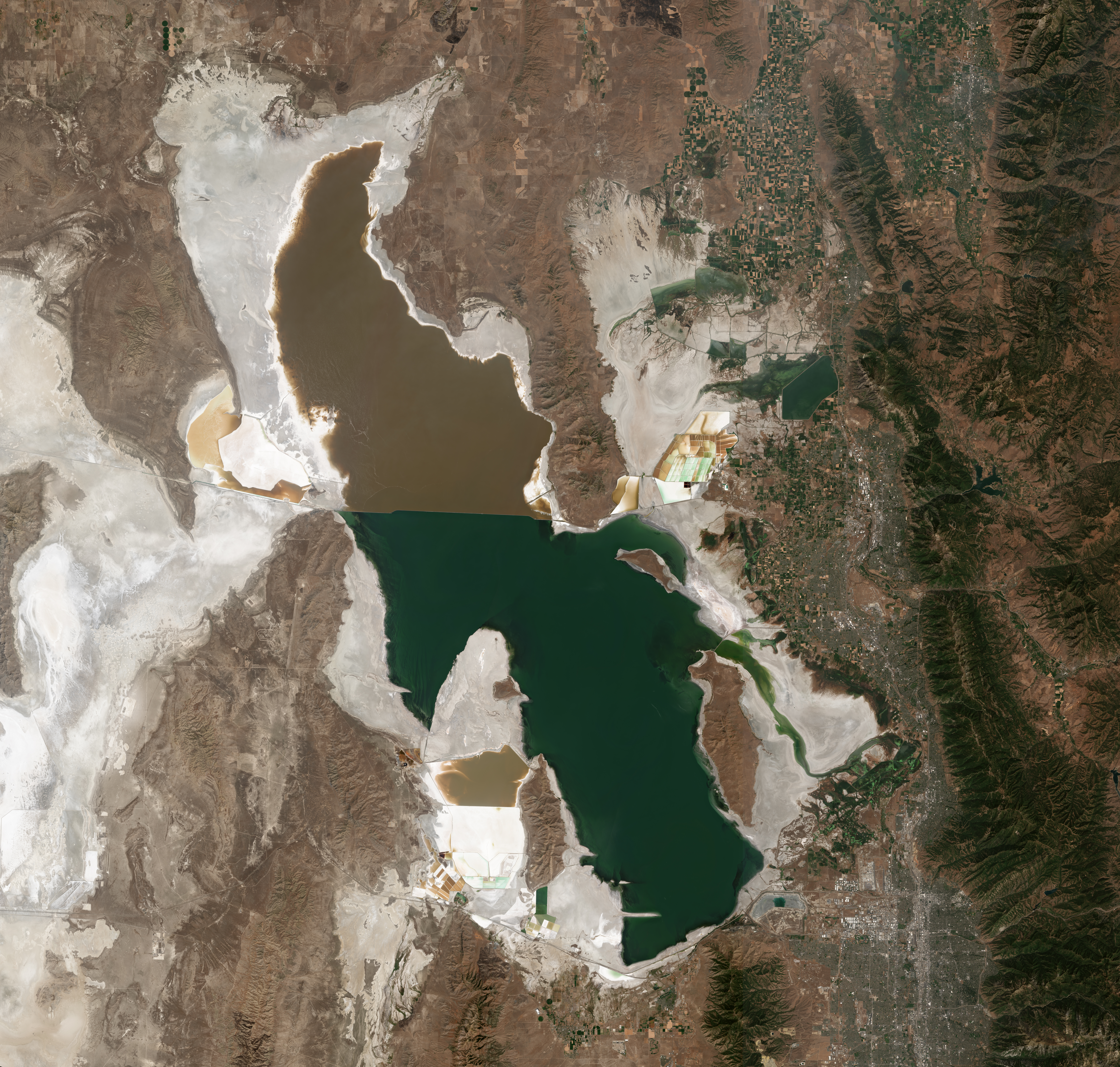
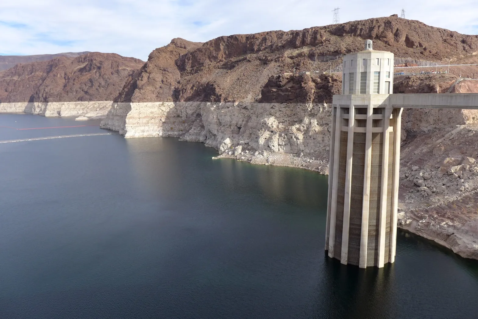
Lake Powell could soon see its level drop below the critical elevation where the Glen Canyon Dam stops being able to generate power.
In the weeks since, however, snowfall throughout the watershed has been at a record or near-record low. Lake Powell, which is filled to just over a quarter of its capacity, could soon see its level drop below the critical elevation where the Glen Canyon Dam stops being able to generate power, even after this week’s storms…
Snowpack in the upper Colorado River basin was above average after big December storms, but an exceptionally dry January and February has water managers worried about levels in Lake Powell and other reservoirs…
Heather Patno, a hydrologist with the Bureau of Reclamation, which oversees operations at Lake Powell, compared the snow season to a yo-yo or a roller coaster that has required forecasts to be repeatedly revised.
The latest projections, Patno told a Glen Canyon Dam working group earlier this month, predicted runoff into the Colorado River will be around 76% of average, and, unless more storms arrive soon, that could drop to 59% of average…
The low range of probable forecasts, Patno said, show that hydropower generation at the dam may become impossible before the end of 2022, marking an uncertain new reality for the 40 million people who rely on Colorado River water between Denver and Tijuana…
Brad Udall: Here’s the latest version of my 4-Panel plot thru Water Year (Oct-Sep) of 2021 of the Colorado River big reservoirs, natural flows, precipitation, and temperature. Data (PRISM) goes back or 1906 (or 1935 for reservoirs.) This updates previous work with @GreatLakesPeck.
In a letter sent to Reclamation last month, John Weisheit and Robin Silver, co-founders of Living Rivers and the Center for Biological Diversity respectively, wrote that demand for water in the basin has outpaced supply for over two decades as the Southwest has been locked in a cycle of megadrought.
The ultimate goal of water managers, according to Weisheit and Silver, should be to “balance the water budget” by immediately reducing consumptive water use in the basin by 20%. Temporarily tweaking release schedules from Lake Powell, the letter said, will not solve the underlying issue that the basin states are using more water than is actually available in the river.
Click the link to read the article on The Craig Press (Eliza Noe). Here’s an excerpt:
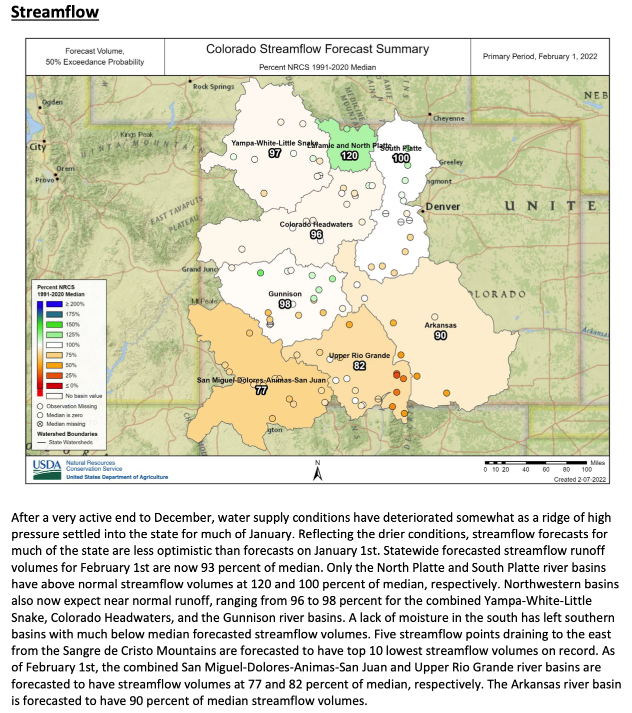
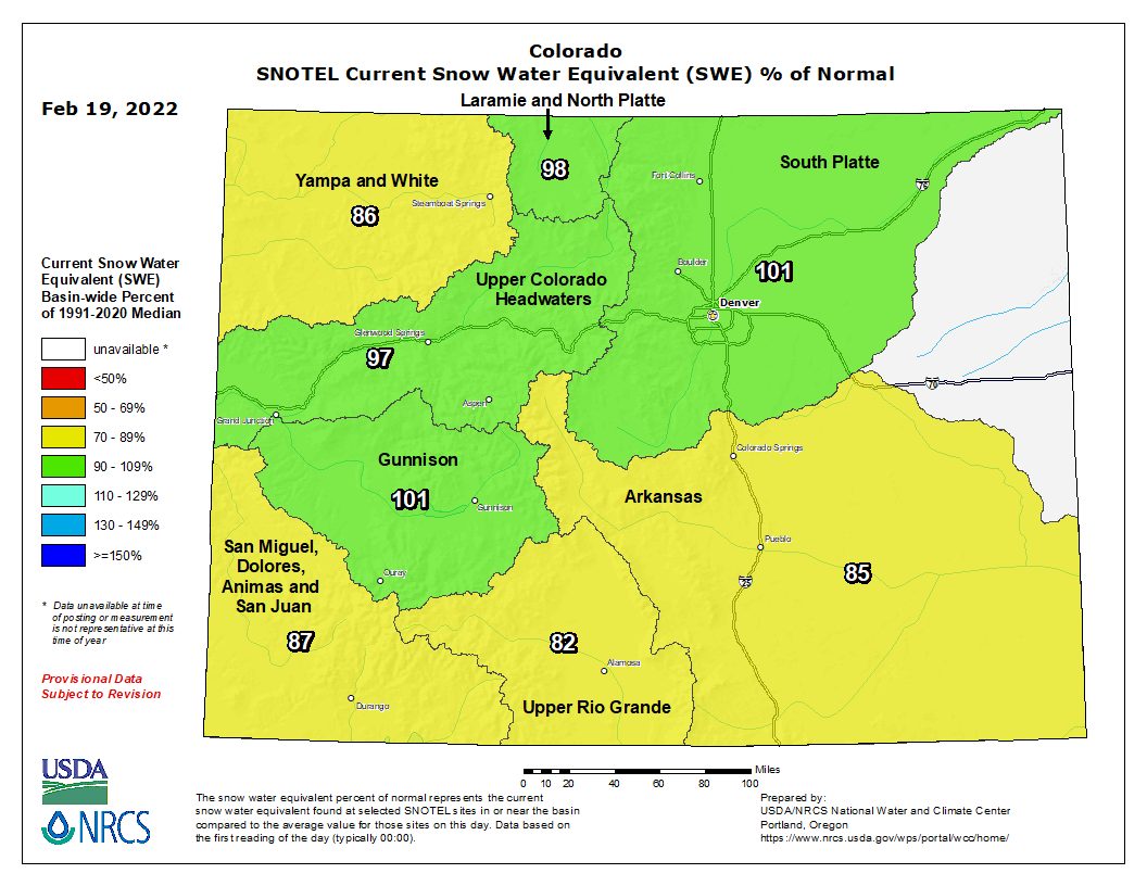
As industries across the Western Slope continue to watch snow and water levels as the days until summer close in, the Colorado River District hosted water experts Tuesday to discuss what certain data points mean and how they reflect the current state of Colorado’s water levels…
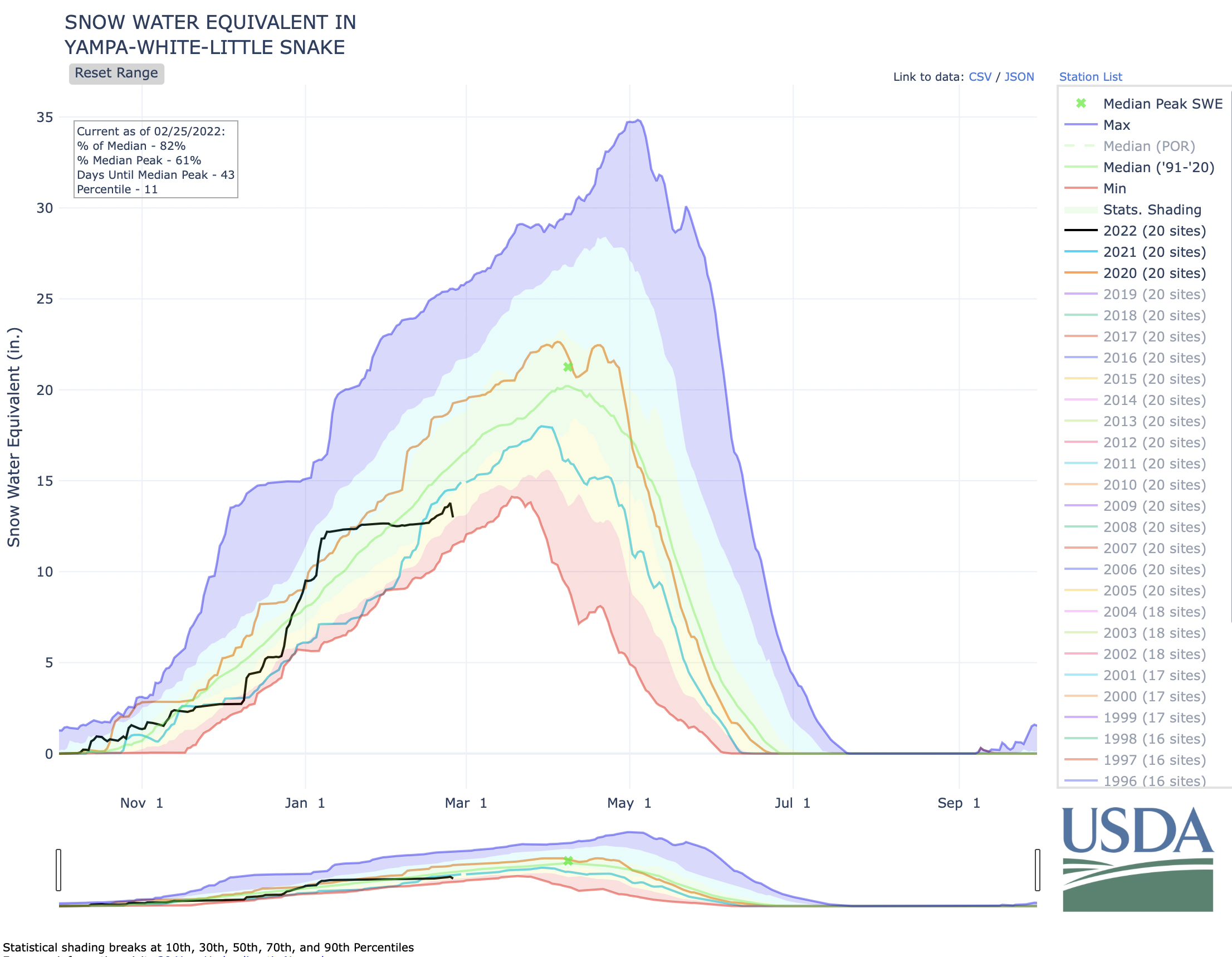
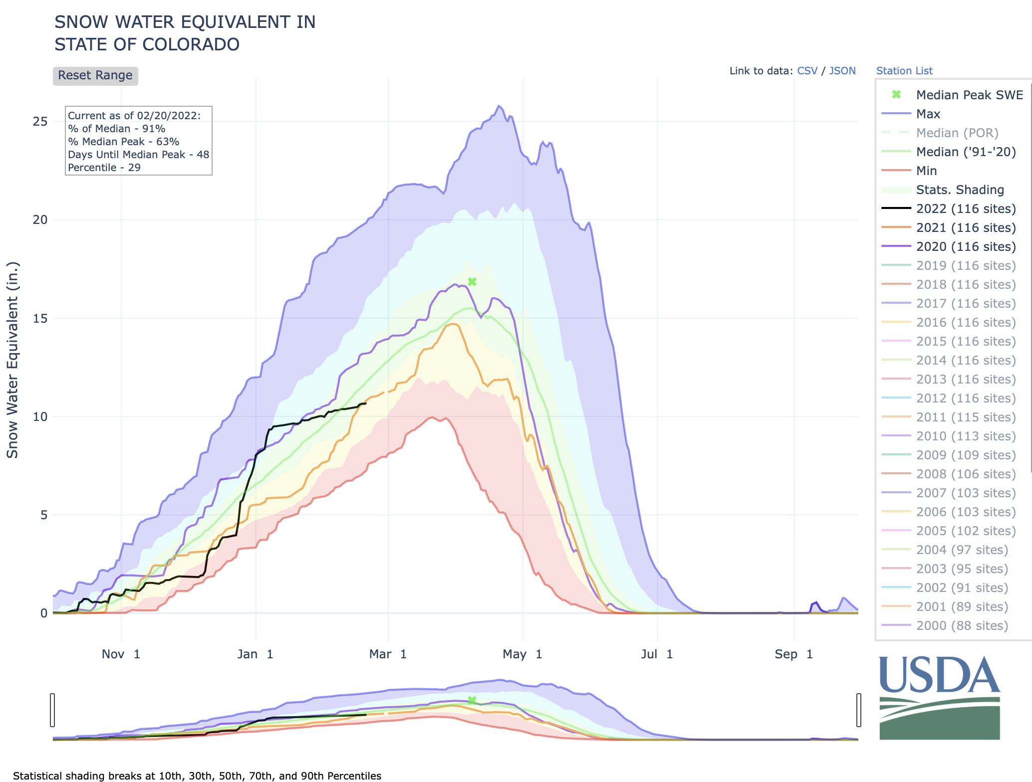
Before Monday, snow in 2022 had been sparse for the northwest corner of the state. According to the USDA’s Natural Resources Conservation Service, the White and Yampa River Basin is currently at 86% of the median snowpack level since 1991. To get this median, the NRCS takes all of the snow patterns over the past 30 years and finds the middle of all of the peaks and snowpack levels. This median is often used as a standard to measure how dry a year is…
This winter, snow water equivalent (SWE) levels for the White-Yampa Basin are currently at 13.4 inches as of Tuesday (the latest available data). SWE is a commonly used measurement used by hydrologists and water managers to gauge the amount of liquid water contained within the snowpack. In other words, it is the amount of water that will be released from the snowpack when it melts.
The SWE median for that same date is 15.5 inches, and this year is slightly behind last winter’s levels, which was at 14.4 inches. The median peak of these levels (meaning the highest amount of SWE levels before they dip) usually happens around April 8. During the most recent drought, this peak has happened earlier in the year, and it sometimes does not reach that average peak, either. In 2021, the peak of snowpack happened during the last week of March, topping at 18 inches. The median peak is 23.1 inches…
“One thing to keep in mind is that the percentage of normal numbers based on the SNOTEL network and snow course measurements are used for runoff prediction,” [Jeffrey] Deems said. “They are not a SWE volume measure. And so they’re used in a statistical forecasting method by the NRCS to project April through July runoff.”
A stock pond that is normally full of water stands dry because of drought on the Little Bear Ranch near Steamboat Springs, Colo., on Aug. 11, 2021. Due to low snowpack, warming temperatures and dry soil during the past two years, followed by the same in 2021, Northwest Colorado is in a severe drought. Credit: Dean Krakel, special to Fresh Water News.
[…]
Across the entire western part of the United States, the trend of a multi-decadal drought is continuing. Gov. Jared Polis visited Craig last summer to speak with local ranchers about the drought’s impact on the Yampa Valley. Currently, agriculture workers in different facets of the industry are looking to see if 2022 might provide some relief.
Fort Lyon Canal Company has seen a storm of litigation, brushes with debt, and general upheaval in its 125 years of existence. It is a credit to its survival the company has issued a commemorative medal to the farmers and landowners owing their very existence to the water sources and reservoirs developed over 125 years. Judy Hensley received one of these medals, as her land, farmed by Nate Cranson, is one of the beneficiaries of that precious water.
Straight line diagram of the Lower Arkansas Valley ditches via Headwaters Magazine
The headwaters and the main gate of the Fort Lyon Canal, the longest and most complicated canal in Colorado, is located just north of North La Junta. “The Fort Lyon Canal’s first 100 years” by O. Ray Dodson is a document based on the 1910 report on “Property of The Fort Lyon Canal Company” by James D. Schuyler, and is the source of historical information gathered by Chris Woodka, former water reporter for the Pueblo Chieftain and now with the South East Water Conservancy District.
The canal, at the time of Dodson’s writing, had a total length of about 113 miles from its head gate to the extreme end at Big Sandy Creek east of Lamar. The principal supplier of water is the Arkansas River, but some of the sources are upslope at Horse Creak Reservoir and other reservoirs developed over the years.
The battle for the water that flows in the Fort Lyon Canal continues to the present time. High Plains A&M, a group of investors led by entrepreneur Terry White, began quietly buying shares in Fort Lyon Canal about five years ago. “It owns or controls 28,566 of the canal’s 98,989 shares, about 30 percent,” wrote Chris Woodka recently. “Its plan, rejected Monday by the Colorado Supreme Court, was to market the water in 28 counties within and outside the Arkansas Valley. Most of the uses listed were domestic or municipal. High Plains owns 115 farms on the canal, directly controlling more than 20,000 shares. It secured options on the remaining shares.”
Woodka further wrote: “The Independent Shareholders Group is aligned with High Plains, which is paying its legal expenses. The ISG owns another 8,287.5 shares of the ditch, about 9 percent, and includes 45 landowners.
• High Plains filed for its change of use decree in late 2002. In November 2003, Fort Lyon shareholders – after five days of hearings – approved diverting water from the canal, as long as it was taken “in priority” along the canal.
• Pueblo Chief District Judge Dennis Maes dismissed change-of-use applications by High Plains and ISG on July 2, 2004. High Plains appealed that decision on Aug. 17, 2004. Oral arguments were held in June. The Colorado Supreme Court upheld Maes’ decision Monday.”
The decision rendered by Pueblo Chief District Judge Dennis Maes was argued for the Lower Arkansas Water Conservancy District by the late Bart Mendenhall of Rocky Ford and Peter Nichols, still the main attorney for LAVWCD.
The May Ranch near Lamar, Colo., has never been plowed. Photo/Ducks Unlimited via The Mountain Town News
A low pressure system developed across the southern Great Plains by February 17 and rapidly tracked northeastward to the Ohio Valley and Northeast a day later. To the northwest of the surface low track, snowfall amounts exceeded 6 inches across northeast Kansas, northern Missouri, and north-central Illinois. In the warm sector of this storm system, severe thunderstorms with locally heavy rainfall (more than 1 inch) affected the Tennessee Valley and parts of the Lower Mississippi Valley. Another low pressure system developed by February 21 with a similar northeastward track to the Ohio Valley. 7-day precipitation amounts, from February 15 to 21, exceeded two inches across much of the Ohio and Tennessee Valleys, Ozarks region, southeast Oklahoma, and parts of northern Texas. Farther to the south and west, little to no rainfall occurred closer to the Gulf Coast along with the Rio Grande Valley and central to southern high Plains. This precipitation pattern during mid-February and the primary storm track across the Ohio Valley are typical during La Nina. Although there was accumulating snow across the northern to central Rockies and northern Cascades this past week, the drier-than-normal pattern persisted throughout most of the West. 7-day temperatures, for the week ending on February 22, averaged above normal across the East, lower Mississippi Valley, and western Gulf Coast. Meanwhile, intrusions of Arctic air began to shift south from Canada into the northern Great Plains and upper Mississippi Valley where weekly temperatures averaged as much as 10 degrees F below normal. Periods of rainfall continued to occur along the windward sides of the Hawaiian Islands…
Following two weeks of worsening conditions across the central Great Plains, additional degradations were made to parts of Kansas and southern Nebraska. These degradations were supported by 30 to 120-day SPI and soil moisture indicators. Snowfall of more than 6 inches during mid-February and favorable snow water equivalent values supported a one category improvement over the Bitterroots of western Montana. A small reduction in exceptional drought (D4) and extreme drought (D3) was made to western and south-central Montana, due to this past week’s snowfall (more than 0.5 inch, liquid equivalent) along with consideration of SWE for the season and long-term SPIs…
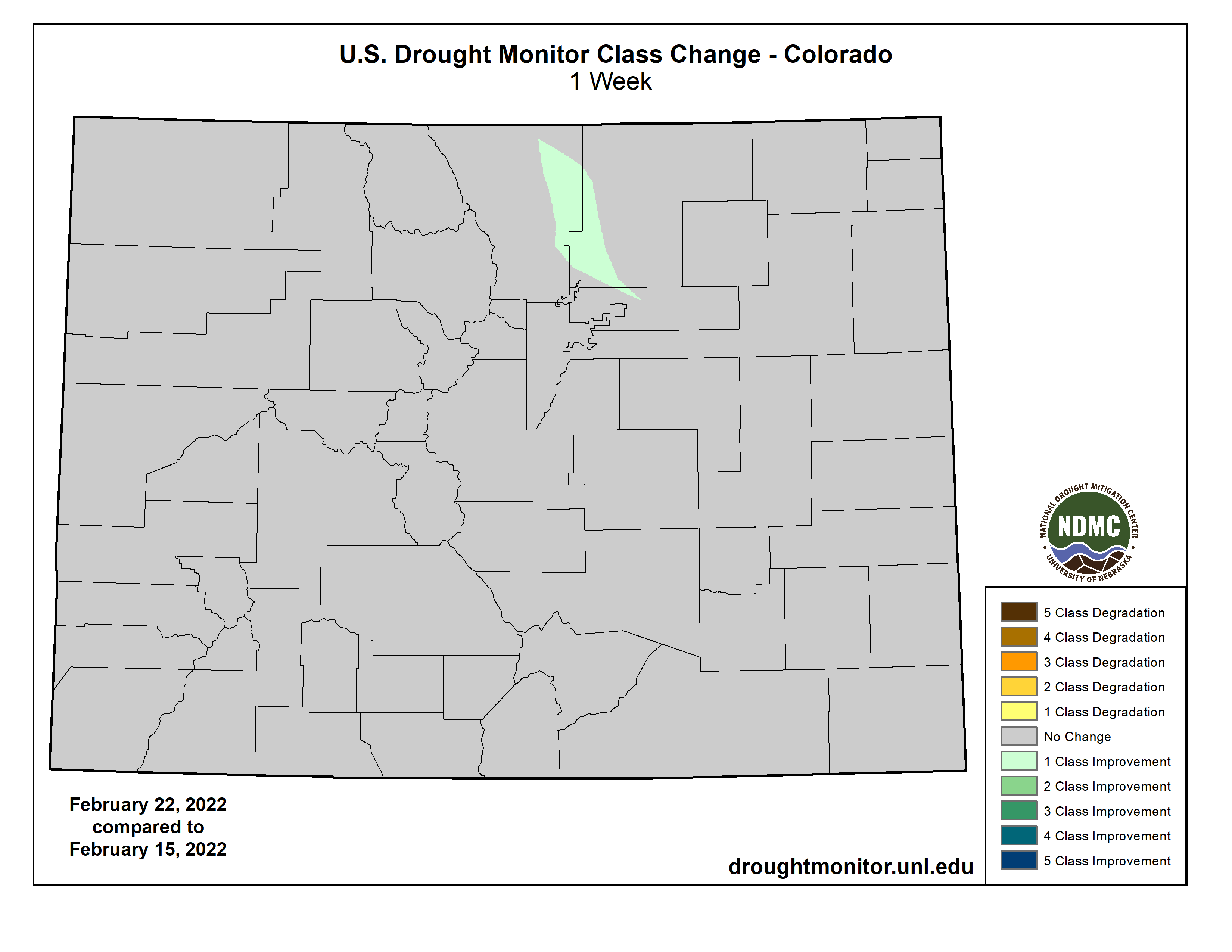
Colorado Drought Monitor one week change map ending February 22, 2022.
Following the wet December 2021 for much of the West, a dry pattern persisted since early January. 2022 year-to-date precipitation averages less than 25 percent of normal throughout much of California and the Great Basin. Snow water equivalent (SWE) continues to decline due to the dry pattern during January and February with SWE falling below 75 percent of normal for much of the southern Cascades, Sierra Nevada Mountains, and Great Basin. Due to the persistently dry pattern since early January, a 1-category degradation was made to parts of northern California and southwest Oregon which reflects the extreme (D3) levels of drought according to the 24-month and 2022 year-to-date SPI, soil moisture indicators, and 28-day average streamflows. Without a major pattern change during March, additional degradations may be needed for California and the Great Basin in the weeks ahead.
A slight expansion of D3 was made to northern Wyoming to be consistent with 12 to 24-month SPIs. Recent snowfall with SWE currently running near to above average prompted a 1-category improvement to the north of Denver, Colorado. Based on a favorable snowpack across the Clearwater and Salmon basins of central Idaho, severe (D2) was improved to moderate (D1) drought for that part of Idaho. Moderate drought (D1) was degraded to severe drought (D2) across the Upper Snake River basin of Idaho as SWE for the headwaters or this basin are nearing the 10th percentile. 7-day precipitation amounts of more than 1 inch, liquid equivalent, prompted a 1-category improvement from extreme (D3) to severe (D2) drought across parts of south-central Montana. Periods of above-normal temperatures coupled with enhanced surface winds support an expansion of severe (D2) to extreme (D3) drought across southern and eastern New Mexico. These worsening conditions are also consistent with SPEI at various time scales and the depiction for western Texas.
A sharp gradient in precipitation was observed from north to south across this region which is typical for La Nina during mid-February. 7-day precipitation amounts, from Feb 15 to 21, exceeded 2 inches across most of the northern half of Mississippi, northern two-thirds of Arkansas, southeastern Oklahoma, and northwestern Texas. A 1-category improvement was made to these areas that received the heavier rainfall. Conversely, farther to the south, a 1-category degradation was made to parts of the lower Mississippi Valley, western Gulf Coast, and central to southern Texas where little to no rainfall occurred this past week. Extreme drought (D3) was added to parts of southwestern Louisiana based on 30 to 90-day SPIs and soil moisture indicators. As temperatures warm heading into March and water demand increases with vegetative growth, additional degradation may be warranted for the lower Mississippi Valley. Although no changes were made this week to the southern high Plains, soil moisture continues to rank in the lowest 5th percentile consistent with much of this region being designated with D3 levels of drought. The lack of adequate soil moisture remains a major concern for the winter wheat crop across the southern Great Plains, while many counties of Oklahoma and Texas remain under a burn ban…
Looking Ahead
On February 24, a major winter storm will be ongoing across the south-central U.S. with snow and freezing rain. This winter storm is forecast to shift to the Midwest and Northeast where there is the potential for more than 6 inches of snowfall. The heaviest precipitation (more than 1 inch), associated with the low pressure system, is likely to affect the increasingly wet areas of the Ohio and Tennessee Valleys. In the wake of this winter storm, bitterly cold temperatures are forecast to overspread the Great Plains and also expand east across the Corn Belt. Onshore flow is expected to bring rain and high-elevation snow to the Pacific Northwest on February 27 and 28. Little to no precipitation is forecast along the Gulf Coast, Florida, and California through the end of February.
The Climate Prediction Center’s 6-10 day outlook (valid Mar 1-5, 2022) favors near to above normal temperatures across much of the contiguous U.S. However, it should be noted that below normal temperatures are likely to return to the northern Rockies, northern Great Plains, and upper Mississippi Valley by the second week of March. Below normal precipitation is favored for much of the Southeast, southern Great Plains, Southwest, and California, while above normal precipitation is most likely from the northern Rockies east to the northern Great Plains and upper Mississippi Valley.
Douglas County Commissioners should not move forward with Renewable Water Resources’ (RWR) request to utilize American Rescue Plan Act (ARPA) stimulus funds to export water from the northern San Luis Valley (SLV). The RWR proposal would significantly impact the economy, environment, and culture of the San Luis Valley, a unique region home to Great Sand Dunes National Park and Preserve and three national wildlife refuges, which collectively attract more than 600,000 visitors annually to the SLV. The SLV cities, farmers, and residents universally oppose the RWR proposal. The project would result in the “buy and dry” of agriculture, which has led to the devastation of other rural communities in Colorado.
As conservation organizations, we represent thousands of hunters and anglers in Colorado. Healthy wildlife habitats are necessary to sustain wildlife populations, and wetlands, riparian corridors, and mesic areas are critical in our arid state. The proposed RWR project would impact fish and wildlife habitats on multiple fronts. Groundwater and surface water resources in the SLV are connected, with aquifers sustaining streamflow, which supports habitat for cold-water fisheries. Therefore, removing water from the aquifers could negatively affect aquatic ecosystems important to the region. For example, the proposed wellfields of 22 to 25 groundwater pumping wells for the RWR project would neighbor the Baca National Wildlife Refuge, potentially impacting the wetland and aquatic ecosystems that support breeding and feeding grounds of migratory birds and waterfowl. Baca is also home to the state’s most viable population of Rio Grande Chub, a state species of concern. Other potentially affected species include the Rio Grande Cutthroat Trout and Gunnison Sage Grouse. The RWR proposal would also require the dry-up of 20,000 irrigated acres in the valley. Impacts to irrigated agriculture in the SLV resulting from the RWR project would also negatively affect fish and wildlife since most of the SLV’s wetlands occur on private property and are sustained through irrigation and water delivery.
Potential Water Delivery Routes. Since this water will be exported from the San Luis Valley, the water will be fully reusable. In addition to being a renewable water supply, this is an important component of the RWR water supply and delivery plan. Reuse allows first-use water to be used to extinction, which means that this water, after first use, can be reused multiple times. Graphic credit: Renewable Water Resources
The RWR plan runs contrary to the Colorado Water Plan. The plan, which guides state water planning and policy, establishes a conceptual framework for guiding negotiations around new transbasin diversion projects, including developing adequate measures to reduce socio-economic and environmental impacts on the basin of origin, which the RWR fails to accomplish meaningfully. The Colorado Water Plan also strongly condemns the practice of “buy and dry,” which has led to significant socio-economic and environmental impacts in rural communities and instead supports alternative approaches such as investments in conservation and smart land-use planning.
More cost-effective strategies exist, including investments in water conservation and water recycling/reuse. And there is no surplus water in the SLV to export. The SLV aquifers are over-appropriated and climatic trends point to less available water. Therefore, the RWR proposal presents a likely expensive, unpopular, and risky approach to meeting the growing water needs of Douglas County.
Denver Basin Aquifer System graphic credit USGS.
Our organizations recognize that Douglas County is growing and reliant on an unsustainable groundwater resource. We encourage Douglas County to use the federal funds to make needed investments to address water supply needs in a way that prioritizes local water supplies, promotes conservation, and creates jobs for the community rather than siphoning these funds to a speculative and costly water export proposal that will have significant impacts on rural Coloradans and the unique environment of the San Luis Valley.
Theodore Roosevelt Conservation Partnership
Trout Unlimited
National Wild Turkey Federation
Colorado Backcountry Hunters and Anglers
Colorado Wildlife Federation
Alexander Funk is the director of water resources and senior counsel at the Theodore Roosevelt Conservation Partnership.
Click the link to read the article on the NOAA website (Michon Scott and Rebecca Lindsey):
At the dawn of the 21st century, drought descended on southwestern North America. Two decades later, the drought continues. Recent NOAA-funded research found that even small additional increases in greenhouse gas emissions will make such decades-long “megadroughts” more common. But limiting greenhouse gas emissions will reduce the intensity of megadrought by reducing the risk of the most intense single-year droughts that occur within the longer period.
These maps show projected changes soil moisture—one way to measure drought—across the Southwest by the late 21st century (2071–2100) depending on how many greenhouse gases people produce in coming decades. In these maps, wetter conditions are blue-green; drier conditions are brown. Summer soil moisture is likely to decline in the future, even in a world where greenhouse gas emissions are kept fairly low (left). But the drying impact is far less severe than in a future in which greenhouse gas emissions are much higher (right).
To project future conditions, the scientists chose two drought events from the historical record—the megadrought that began in 2000 and the extreme single-year drought of 2002—and used them as test cases for what droughts like those might look like in a future, warmer climate. Even in the model experiments with the lowest future greenhouse gas emissions, the risk of 21-year soil moisture deficits as bad as or worse than the current drought was roughly 50 percent.
But that doesn’t mean there’s no benefit to reducing how many greenhouse gases we emit. The researchers also found that reducing greenhouse gas emissions will significantly lower the risk of extremely dry single-year droughts within a longer megadrought. If we can reduce the occurrence of intense, single-year droughts, it will reduce the overall intensity of megadroughts. That will give us a better chance to adapt to the drier conditions we may not be able to avoid.
References
Cook, B. I., Mankin, J. S., Williams, A. P., Marvel, K. D., Smerdon, J. E., Liu, H. (2021). Uncertainties, Limits, and Benefits of Climate Change Mitigation for Soil Moisture Drought in Southwestern North America. Earth’s Future, 9(9). https://doi.org/10.1029/2021ef002014.
A rancher digs a boot heel into the dry ground of the Little Bear Ranch near Steamboat Springs, Colo., during the Northwest Colorado Drought Tour on August 11, 2021. Credit: Dean Krakel, special to Fresh Water News.
Nebraskans know every drop of water is precious. Agriculture is our top industry. It makes up 20% of our economy, and it generates one in four jobs in our state. Access to water makes this possible. We have the most irrigated acres of cropland in the country. Three of eight acres of farmland in Nebraska are irrigated.
Fifty years ago, far-sighted Nebraskans set up a system of water management, including our Natural Resources Districts (NRDs), that has allowed us to manage our water based on river basin. This has allowed our state to maintain the Ogallala Aquifer within one foot of where it was in the 1950s.
The Ogallala aquifer, also referred to as the High Plains aquifer. Source: National Oceanic and Atmospheric Adminstration
By contrast, Colorado has mined their water. The Ogallala Aquifer under Colorado has dropped nearly 15 feet since the 1950s. Now, Colorado is aggressively planning new developments that threaten Nebraska’s water resources. Last year, Colorado released their South Platte Basin Implementation Plan. It was updated last month and now includes 282 total projects to meet their growing demands. Altogether, these projects cost an estimated $9.8 billion.
Governor Clarence J. Morley signing Colorado River compact and South Platte River compact bills, Delph Carpenter standing center. Unidentified photographer. Date 1925. Print from Denver Post. From the CSU Water Archives
Thankfully, 100 years ago Nebraskans negotiated an agreement with Colorado over the use of South Platte River water. The South Platte River Compact (Compact) was signed by Nebraska and Colorado in 1923 and ratified by Congress in 1926. It entitles Nebraska to 120 cubic feet per second (cfs) of water from April 1st through October 15th (irrigation season) and 500 cfs of water from October 16th through March 31st (non-irrigation season). Under the Compact, we can only claim our non-irrigation season water entitlement by building a canal and reservoir system—known as the Perkins County Canal—along the South Platte River. Until we build the canal, Colorado has no obligation to deliver the water.
South Platte River Storage Study Area. Illustration shows water availability, in blue circles, compared with demand at various places along the South Platte River. The yellow area is the study area. (Illustration by Stantec).
As Colorado’s desire for water grows, they’re acting as if Nebraska’s non-irrigation season water rights under the Compact don’t exist. In 2016, the Colorado Legislature passed HB16-1256, the South Platte Water Storage Study, into law. Its purpose was to identify water storage options along the lower South Platte River. Colorado wants to make sure no water “in excess of the minimum legally required amounts” gets to Nebraska. In the study’s final report, Colorado clearly assumes that Nebraska’s legal requirement is only the 120 cfs during irrigation season. Since we haven’t built the canal, Colorado is not planning to deliver any water to us during non-irrigation season. Zero.
The good news is that the Compact gives Nebraska undeniable authority to construct a canal to claim our non-irrigation water flow. It even gives us legal entitlement to land in Colorado to build it. Senator Dan Hughes, of District 44, has prioritized LB 1015, authorizing the Department of Natural Resources to design, construct, and operate the Perkins County Canal and reservoir system. My budget recommendation to the Legislature includes $500 million for the project. This is a bargain compared to the nearly $10 billion Colorado is preparing to spend on their water resources.
Our proposed canal has caused a stir in Colorado. In response to our plans, a legislator in Colorado introduced SB22-126 earlier this month to prioritize water storage projects in the South Platte Basin. Colorado’s leaders believe that “possession is nine-tenths of the law.” I am concerned that even though Nebraska has clear entitlements to South Platte River water under the terms of the Compact, it will be difficult for us to claim what we are owed once municipalities in Colorado become reliant on the water.
There’s no doubt that Colorado plans to take the 500 cfs of water guaranteed to Nebraska during non-irrigation season under the Compact. On February 7th, a coalition of water districts gave a presentation to the Colorado Legislature on ways to shore up South Platte River resources. The presentation indicates that Colorado only recognizes its 120 cfs delivery commitment to Nebraska during irrigation season. In other words, the presentation assumes Nebraska is not entitled to receive a single drop of South Platte River water for almost half the year.
We must take action now to protect this water from being taken. Our ag producers rely on it for irrigation. Communities along the Platte River use it for drinking water. The water is critical to power generation in Nebraska, and our natural habitats along the Platte depend on these water flows.
People have asked, “why not slow down and discuss reworking the terms of the compact?” Any renegotiation would take time to hammer out. It would require approval from the Colorado Legislature and Nebraska’s Unicameral. What are the odds of that happening anytime soon? Keep in mind: delays only benefit Colorado. Remember, Colorado is trying to accelerate their work along the South Platte River. Pausing our plans, while they move full steam ahead, would put us at risk. The longer we delay, the more we risk losing access to the water we’re due.
This month, I’ve held town halls across the state to inform Nebraskans about our water rights with Colorado. There has been overwhelming support for moving forward on the canal. People understand that the price of inaction is far higher than the funding needed to secure our water rights. I’ll encourage you to do what I asked of them: contact your state senator to let them know your thoughts on LB 1015. The passage of this bill is a necessary first step.
Fifty years from now, Nebraskans will look back on this generation. Will they say we had the foresight to secure our water resources? Or will they say this generation failed?
If you have questions about the proposed canal, write me at pete.ricketts@nebraska.gov or call 402-471-2244.
Wattenberg Oil and Gas Field via Free Range Longmont
Click the link to read the article on Big Pivots (Allen Best):
A press release distributed by United Power this week describes a new agreement as ground-breaking. That cliché truly applies in this case as the Brighton based electrical cooperative and a company called Transitional Energy have signed a letter of intent to develop geothermal resources among some of the thousands of oil and gas wells in the service territory of United Power north and east of Denver. United says it has 5,300 well-bores in its service territory, which overlaps with the Wattenberg, one of the nation’s most productive oil-producing fields.
Many oil and gas operators use electricity to power drilling rigs and other well-pad equipment. In this pilot project, owners-operators of wells in the Wattenberg field north of Denver—both working and abandoned—will be able to tap the warmth of the wells to generate electricity. In this way, they can offset their electricity purchase from United while reducing their greenhouse gas footprints.
“Reuse of existing wells and infrastructure is a capital-efficient way to use the heat beneath our feet,” the press release said.
The website for Transitional Energy says the technology has a payback period of 5 years. Transitional Energy was launched with a $500,000 grant from the Colorado Office of Economic Development and International Trade in 2020. It has an office on 17th Street in Denver. In January the company also received a $2.4 million grant from the U.S. Department of Energy’s Geothermal Technologies Office, according to the company’s website. That grant is to be used to develop up to one megawatt of electrical generation from the Blackburn Oilfield in Nevada.
United has also distinguished itself as an innovator in other ways. In 2019, it put into operation a 4-megawatt battery storage complex, still the largest in Colorado.
“United Power is excited to work on this innovative pilot project,” stated Dean Hubbuck, United Power’s chief energy resources officer. “Utilizing clean, economical geothermal energy to provide local power that can be dispatched when needed is a critical component of our growing energy portfolio. Geothermal energy represents a huge untapped renewable resource that can reduce our reliance on power from other traditional sources.”
Hubbuck said he believes a pilot will occur by summer. The technology has been deployed in Europe and elsewhere, he said.
Click the link to read an article on The Guardian (Alexis Petridis). Here’s an excerpt:
Gary Brooker, lead singer of English band Procol Harum, dies aged 76
Pop music moved at high speed in the 1960s, but even so the story behind the song for which Gary Brooker was always going to be remembered almost beggars belief. It was taped in April 1967, the same month that the band who recorded it formed: they hadn’t even got around to recruiting a drummer yet and had to use a jazz player moonlighting as a session musician. A couple of weeks later, Paul McCartney was interrupting his first date with his future wife Linda in order to rush to the DJ booth at Soho’s Bag O’Nails club, demanding to know what the hell he was playing (“God, what an incredible record,” he subsequently enthused) and John Lennon was informing a journalist friend that all current pop music was “crap” except for “that dope song, A Whiter Shade of Pale – you hear it when you take some acid and wooooh!”
A few weeks after that, it was No 1, a position it held until the middle of July. You do wonder how incredulous Brooker must have felt. He had only started Procol Harum as a last resort. He had left the minor R&B band the Paramounts with the intention of becoming a full-time songwriter, only to discover that no one wanted to buy the songs he had written with lyricist Keith Reid, so he would have to sing them himself. And now here he was less than two months later, on Top of the Pops and feted by the Beatles as the vanguard of pop. A Whiter Shade of Pale caused so much commotion that the effect was discombobulating: Procol Harum organist Matthew Fisher once recalled being mortified after they were parachuted into a headlining slot over the Jimi Hendrix Experience when “we weren’t one 10th as good as him”. Perhaps it was just as well he didn’t know that on the other side of the Atlantic, Brian Wilson of the Beach Boys – in the throes of mental collapse and on the verge of abandoning his latest opus, Smile – had taken A Whiter Shade of Pale as another signal that he was finished: “I was so sensitive for the dramatic organ sound that I thought it was my funeral tune,” Wilson later recalled.
It was one of rock history’s great lightning-in-a-bottle moments. A Whiter Shade of Pale was completely of the moment – the psychedelic era was all about opening new vistas in pop music, and if there’s one thing everyone agreed on, it was that they had never heard anything like it before – while also harking to pop’s recent past and pointing towards its future. Brooker’s vocal spoke loudly of the hours he had put in touring the R&B clubs, belting out covers of Solomon Burke and the Impressions for the nation’s mods; the tune’s allusions to Bach and its dense, elusive lyrics – open to wild interpretation – presaged the arrival of progressive rock. It spawned hundreds of covers by everyone from Joe Cocker to Jackie Mittoo – soul versions, reggae versions, jazz interpretations, disco versions, mock-Gregorian chant versions – as well as a little subgenre of British psychedelia populated by obscure bands trying to make records that sounded like it: Meditations by Felius Andromeda and Reputation by Shy Limbs are two examples prized by psych collectors.
The chances of a band walking into a studio for the first time and immediately recording one of rock’s impermeable classics – 10m copies sold – are incredibly slim…
Perhaps A Whiter Shade captured its era so perfectly that it succeeded in transcending it. None of 1967’s other big songs, not even All You Need Is Love or Pink Floyd’s See Emily Play, feels quite so evocative of a mythic, idealised version of the British Summer of Love – of what the press took to calling “the beautiful people” drifting through London on a warm evening in a stoned, optimistic haze – which meant that whenever a film director or a radio DJ wanted a surefire burst of beatific nostalgia, they invariably reached for it. It turned up on umpteen soundtracks – everywhere from The Big Chill to Breaking the Waves – and in 2004 was named the most-played song on British radio over the last 70 years.
Or maybe it was just a completely fantastic song, of the kind that takes an inordinate combination of talent and luck to come up with even once in a career. You could argue it’s unfair that Gary Brooker’s musical legacy hinges on one song in the popular imagination. On the other hand, if you’re going to be largely remembered for one song, it might as well be one like that.
A forest fire next to the Bitterroot River in Montana. UCLA-led research revealed that larger fires tend to be followed by larger increases in streamflow. | Photo by John MacColgan/Creative Commons
Click the link to read the release from UCLA (Anna Novoselov):
Forest fires can have a significant effect on the amount of water flowing in nearby rivers and streams, and the impact can continue even years after the smoke clears.
Now, with the number of forest fires on the rise in the western U.S., that phenomenon is increasingly influencing the region’s water supply — and has increased the risk for flooding and landslides — according to a UCLA-led study published today in the Proceedings of the National Academy of Sciences.
Researchers examined streamflow — a measure of water volume over time in rivers and streams — and climate data for 179 river basins. (Basins are areas of land where precipitation collects and drains into a common outlet.) All of the areas were located in the western U.S., and all had been affected by forest fires between 1984 and 2020.
Using a mathematical model they developed, the scientists discovered that streamflow in the years after a fire tended to be higher than scientists would expect based solely on climate conditions, and that larger fires tended to be followed by larger increases in streamflow.
In basins where over 20% of the forest had burned, streamflow was 30% greater than expected based on climate conditions, on average, for an average of six years.
Park Williams, a UCLA associate professor of geography and the study’s lead author, said forest fires enhance streamflow because they burn away vegetation that would otherwise draw water from soil and block precipitation before it ever reached the soil. Intense forest fires can also “cook” soils, making them temporarily water repellent.
From 1984 through 2020, the amount of forested area burned each year in the West increased elevenfold, and that trend is expected to continue or even accelerate due to climate change.
“As a result, we’re starting to see sequences of years when large portions of forest are burned across some very important hydrological basins such as those in California’s Sierra Nevada,” Williams said.
The study’s findings suggest that wildfires will soon become yet another important consideration for those in charge of the supply and distribution of water resources. Each year, the region’s water managers must carefully calculate how much water will be available and determine how to conserve and allocate it.
In one sense, the increase in streamflow from forest fires may be beneficial, Williams said.
“This could come as good news to dry cities like Los Angeles, because it could actually enhance water availability,” Williams said.
But other outcomes could be troubling. For example, in the coming decades, too much water could overwhelm reservoirs and other infrastructure, and could increase the risk for catastrophic flooding and landslides in and around burn areas.
To adapt to increasing flood risks, Williams said, water managers in California may have to lower the water levels in reservoirs in the fall and winter to make room for excess water from major rainfall and snowstorms. Such a strategy could avoid disastrous flooding in some cases, but it could also put communities at risk for having too little water during the state’s increasingly hot, dry summers.
Water after a forest fire also tends to be heavily polluted, carrying mud, debris and large sediment loads. So even if the quantity of available water increases after a large fire, it’s likely that water quality will worsen.
Williams said he hopes the findings help water managers and climate scientists make better predictions about water availability and flood risk.
“Water is a really heavy and destructive thing,” Williams said. “It’s great when it comes to us in the expected amount. It is catastrophic when it shows up unexpectedly.”
Winter storms on Tuesday blanketed Southwest Colorado, dropping 6 inches of snow in Dolores and Mancos, and more than a foot on mountain passes. A winter storm that began Monday afternoon and evening stretched into Tuesday largely followed predictions from the National Weather Service. A second storm Tuesday evening is expected to more than double snow totals and leave travelers facing blizzard conditions in places…Dolores received about 6 inches of snow, and Mancos, 5 to 7 inches, depending on elevation. Durango received 2 to 4 inches of snow, and Pagosa Springs, 1 to 3 inches…[Jim] Andrus reported that snowfall for Cortez was 67% of normal, with 16.7 inches by Feb. 22. Cortez received 10.6 inches in January. Andrus measured Tuesday morning’s snow water equivalent to be 0.27 inch of precipitation, and predicted that it would rise to 0.5 to 0.6 inch of precipitation by the end of the storm. He described the storm as a strong jet stream parked over the Four Corners…Telluride received 11 inches of new snow from the storm, and Purgatory received 14 inches.
As of Tuesday, combined totals for five SNOTELS that measure snowpack in the Dolores River Basin showed 90% of normal, up from 89% on Monday. The Animas River Basin snowpack is at 87% of normal. The SNOTEL stations for the Dolores Basin are located at El Diente Peak, Lizard Head Pass, Lone Cone, Scotch Creek, and Sharkstooth. Winter season snowpack statewide was 90% of normal as of Feb. 22, according to the Natural Resources Conservation Service.
Westwide SNOTEL basin-filled map February 22, 2022 via the NRCS.
We write today to bring to your attention a matter in Colorado’s San Luis Valley where your agencies play an important and unique oversight role under Public Law 102-575. Through the attached letter from the Rio Grande Water Conservation District (the District), we have been alerted to a proposal called Renewable Water Resources which would transfer groundwater out of the basin from the confined aquifer beneath the Great Sand Dunes National Park, Baca National Wildlife Refuge, and Closed Basin Project. After hearing concerns from our San Luis Valley constituents about this proposal for months, the District’s letter from yesterday, and considering Colorado’s current exceptional drought, we both oppose this proposal. Further, we ask for your attention under the Wirth Amendment, if an opportunity for review comes before your agencies.
The San Luis Valley is experiencing unprecedented drought that has placed a severe demand on local water resources. Valley residents, including farmers, ranchers, and business owners, rely heavily on groundwater aquifers to support their economy and way of life. Since 2005, in response to this drought, local farmers have undertaken an ambitious, collaborative effort to reduce their own pumping with the goal of achieving sustainability. This export proposal continues to seek funding to move forward despite the fact it would exacerbate local water challenges, even with conservation efforts. In addition to concerns from the District, five San Luis Valley counties are opposed to this proposal.
Public Law 102-575, also called the “Wirth Amendment”, was passed in 1992 and provides a legal framework and elevated standard of environmental review for any transfer of groundwater out of the basin that may adversely affect these public resources. We highlight this law because of its relevance to the San Luis Valley and an elevated standard of review for any project that might adversely affect Great Sand Dunes National Park, Closed Basin Project, Baca National Wildlife Refuge. For your convenience, we have pulled out the relevant language on page 64 of P.L. 102-575 (Title XV, Section 1501-1504):
SEC 1501: PERMIT ISSUANCE PROHIBITED
(a) No agency or instrument of the United States shall issue any permit, license, right-of way, grant, loan or other authorization or assistance for any project or feature of any project to withdraw water from the San Luis Valley, Colorado, for export to another basin in Colorado or export to any portion of another State, unless the Secretary of the Interior determines, after due consideration of all findings provided by the Colorado Water Conservation Board, that the project will not:
(1) increase the costs or negatively affect operation of the Closed Basin Project;
(2) adversely affect the purposes of any national wildlife refuge or Federal wildlife habitat area withdrawal located in the San Luis Valley, Colorado; or
(3) adversely affect the purposes of the Great Sand Dunes National Monument, Colorado.
(b) Nothing in this title shall be construed to alter, amend, or limit any provision of Federal or State law that applies to any project or feature of a project to withdraw water from the San Luis Valley, Colorado, for export to another basin in Colorado or another State. Nothing in this title shall be construed to limit any agency’s authority or responsibility to reject, limit, or condition any such project on any basis independent of the requirements of this title.
The Colorado delegation previously raised similar concerns with your agencies. In 2014, Senator Bennet led a letter with Senator Udall, Congressmen Tipton and Gardner elevating these same responsibilities to your attention in the face of a similar groundwater export proposal.
On behalf of our San Luis Valley constituents and the water resources so critical to their economic future, we must oppose the Renewable Water Resources proposal. We thank you for your assistance when your agencies are presented with the opportunity to review this matter.
Rio Grande River Basin Drought Monitor map February 15, 2022.
Many Indian reservations are located in or near contentious river basins where demand for water outstrips supply. Map courtesy of the Bureau of Reclamation.
Following a trip to the Gila River Indian Community with members of the Arizona congressional delegation today, Secretary of the Interior Deb Haaland announced the Department’s plan to fulfill settlements of Indian water rights claims using historic funding from President Biden’s Bipartisan Infrastructure Law.
The Law invests more than $13 billion directly in Tribal communities across the country and makes Tribal communities eligible for billions more in much-needed investments. That includes $2.5 billion to implement the Indian Water Rights Settlement Completion Fund, which will help deliver long-promised water resources to Tribes, certainty to all their non-Indian neighbors, and a solid foundation for future economic development for entire communities dependent on common water resources.
Following feedback received from Tribal consultation, the Department will allocate $1.7 billion of Infrastructure Law funding this year to enacted settlements that have outstanding federal payments necessary to complete their terms.
“Water is a sacred resource, and water rights are crucial to ensuring the health, safety and empowerment of Tribal communities. With this crucial funding from President Biden’s Bipartisan Infrastructure Law, the Interior Department will be able to uphold our trust responsibilities and ensure that Tribal communities receive the water resources they have long been promised,” said Secretary Haaland. “I am grateful that Tribes, some of whom have been waiting for this funding for decades, are finally getting the resources they are owed.”
Thanks to investments made by the Bipartisan Infrastructure Law’s Indian Water Rights Settlement Completion Fund and funds available from the existing Reclamation Water Settlement Fund, the following Tribes and settlements will receive funding this year: Aamodt Litigation Settlement (Pueblos of San Ildefonso, Nambe, Pojoaque, and Tesuque), Blackfeet Nation, Confederated Salish and Kootenai Tribes, Crow Nation, Gila River Indian Community, Navajo-Utah Water Rights Settlement and Navajo-Gallup Water Supply Project, San Carlos Apache Nation, Tohono O’odham Nation, and White Mountain Apache Tribe.
The Reclamation Water Settlement Fund was created by Congress in 2009 and receives $120 million in mandatory funding annually from 2020 through 2029. Pending congressional action on the President’s FY 2022 budget, additional Tribes will also see investments to address ongoing federal obligations such as operation, maintenance and repair costs under existing settlements.
There are 34 congressionally enacted Indian Water Rights settlements as of November 15, 2021, when the Infrastructure Law was signed. Indian reserved water rights are vested property rights for which the United States has a trust responsibility. Federal policy supports the resolution of disputes regarding Indian water rights through negotiated settlements. Settlement of Indian water rights disputes breaks down barriers and helps create conditions that improve water resources management by providing certainty as to the rights of all water users who are parties to the disputes.
As part of the implementation strategy, an Indian Water Rights Settlement Completion Fund Executive Committee has been established, comprised of the Commissioner of the Bureau of Reclamation, Chairperson of the Working Group on Indian Water Settlements, Director of the Bureau of Indian Affairs, Assistant Secretaries of Water and Science and Indian Affairs, and the Solicitor. The Executive Committee will recommend future allocations of the remainder of the Completion Fund to the Secretary based on current project needs.
Click the link to read the article on Ark Valley Voice (Jan Wondra):
A megadrought is defined as a drought lasting two decades or longer. According to Climate Scientist Jason Smerdon, co-author of a drought study by the Lamont-Doherty Earth Observatory of Columbia University, not only do they give us a 94 percent certainty that this mega-drought will continue, they say we could face years of continued drought.
In fact, University of California Los Angeles geographer Park Williams, the study’s lead author, said with dry conditions likely to persist, it would take multiple wet years to remediate the effects. “It’s extremely unlikely that this drought can be ended in one wet year,” he said.
As we in Chaffee County and surrounding counties know from the past couple of years, as spring arrives, the snowpack is just soaking into the parched earth, rather than running off into streams and rivers. This doesn’t bode well for the four major rivers that originate in the Colorado Rockies; the Colorado, the Platte, the Arkansas, and the Rio Grande, and the reservoir systems and hydroelectric plants they serve…
By analyzing tree rings, the scientists observed that periods of severe drought are marked by high degrees of soil moisture deficit; this is the moisture variance from normal saturation.
Location of proposed Bolts Reservoir at the south end of the town of Minturn. Photo credit: Eagle River Water & Sanitation District
From email from the Eagle River Water & Sanitation District (Diane Johnson):
The Eagle River Water & Sanitation District and Upper Eagle Regional Water Authority closed on the purchase of the Bolts Lake site, a 45-acre parcel at the south end of Minturn, an historic mining and railroad town, with the intent to develop a water supply reservoir up to 1,200 acre-feet in volume.
The district, the authority and the landowner, Battle North, last February reached an agreement for the district and authority to purchase the site and commenced a year-long due diligence period that recently concluded with the purchase.
“Bolts Lake will provide critical in-basin water storage to the district and authority’s portfolio of water resources. Once constructed, the reservoir will improve the resiliency of our community’s water supply as we adapt to the impacts of a changing climate, and it will provide a water supply for important community initiatives such as workforce housing.” says Jason Cowles, district director of engineering and water resources.
In addition to serving all existing district and authority customers, water stored in the reservoir will also be used to augment diversions of the town of Minturn and Battle North’s planned future development on the land surrounding the reservoir site. The Minturn Town Council approved an Intergovernmental Agreement with the district and authority on Feb. 2 that secured augmentation rights for Minturn in exchange for a simplified future reservoir permitting process and other considerations.
The reservoir development project is projected to take up to 10 years to complete. The construction of the reservoir will require deep excavation within the former lake footprint to roughly triple the volume of the original reservoir capacity. Based on a planned joint effort between the district, the authority and Battle North, the removed material will be used to cap the surrounding property on the Bolts site that furthers remediation of mining impacts on the property and improves downstream water quality in the Eagle River.
An additional community benefit will be that the district and authority have agreed to allow passive recreation on the reservoir, including non-motorized boating and fishing, so long as it doesn’t interfere with the reservoir’s main purpose of water supply.
The next step for development of the reservoir is federal, state, and local permitting; because the property is not located on public lands and was previously used as a reservoir, the permitting process will be streamlined compared to water projects that are proposed on public lands, Cowles explained.
Bolts Lake was originally constructed in the 1890s by Ben Bolt as a freshwater lake for recreational boating and fishing for the local homesteader and mining community. The lake and surrounding property were sold to the Empire Zinc Company in 1917 and areas surrounding the lake were used by the Eagle Mine operation as mine tailings repositories; there is no evidence that mine tailings were ever deposited in the lake. The mine closed in the early 1980s and the surrounding land was placed on the list of Superfund sites in 1986. However, the lake property is not included in the Superfund-regulated area. In the 1990s, the state deemed the dam unsafe and ordered it to be breached. Bolts Lake has remained empty since that time.
In the 1980s and ‘90s, the property surrounding the lake was remediated. The efforts last summer by Battle North with the support of the district and authority to clean up portions of the Eagle Mine Superfund Site surrounding the lake have been deemed completed, with the U.S. Environmental Protection Agency (EPA) and the Colorado Department of Public Health and Environment (CDPHE) approving the final completion report on Dec. 22, 2021.
Battle North representatives approached the district and authority in 2017 to determine if it made more sense for the water providers to take over the lake property and develop the reservoir. The site can accommodate a 1,200-acre foot reservoir on about 45 acres, with enough water storage to serve the potential Battle North development, the Town of Minturn and significant surplus storage that could benefit areas served by the district and authority. “The purchase of the reservoir site and the agreements that set us on the path to developing this important water supply reflect this community’s values around cooperation and water security,” says District and Authority chairmen Bill Simmons and George Gregory, respectively. “We are grateful to Battle North for recognizing the community need and bringing us this unique opportunity.”
“We are very much looking forward to continued collaboration with the district, the authority, the Town of Minturn, and the team that will be involved to complete reservoir construction,” says Tim McGuire, Battle North’s chief of operations. “Delivering water security to the Town of Minturn and greater portions of the Eagle River Valley is something to celebrate. All parties came to the table with the best of intent and flexibility to get this done.”
“The Town of Minturn supports the important undertaking by the Eagle River Water & Sanitation District and Upper Eagle Regional Water Authority to rebuild Bolts Lake,” says Minturn Mayor Earle Bidez. “Climate change will continue to result in unpredictable water supplies from the Eagle/Colorado River Basin well into the future. The construction of Bolts Lake Reservoir represents a significant project to address the water future of the upper valley communities.”
Highline Canal trail map. Credit: Google maps via Water Education Colorado
Click the link to read the article from Denver Water (Jay Adams and Steve Snyder):
The High Line Canal Conservancy has formalized a public-private partnership with Denver Water and 11 jurisdictions to preserve, protect and enhance the 71-mile High Line Canal.
Members of the new Canal Collaborative will work together to support the canal corridor as it evolves from its role as an irrigation channel owned by Denver Water and expands into a new linear park and emerging stormwater management system.
enver Water CEO/Manager Jim Lochhead takes part in a signing ceremony held Jan. 26 to officially launch the Canal Collaborative, a public-private partnership aimed at guiding the future of the High Line Canal. Photo credit: Denver Water.
The agreement creating the collaborative formalizes roles and responsibilities for the long-term management, funding and governance of the canal.
“This partnership was built on the premise that together we can do more for the canal than any one entity can do alone. The deep respect for varied local perspectives, combined with the power of the community’s vision and commitment has been a winning strategy that has resulted in a common vision and new governance structure to ensure the canal is cared for as a vital backbone of our region’s open space system for generations to come,” said Harriet Crittenden LaMair, executive director of the High Line Canal Conservancy.
“Denver Water has a century-old canal that has outlived its usefulness,” said Jim Lochhead, CEO/Manager at Denver Water. “We wanted to transform the canal into a recreational and environmental crown jewel for the region and with the help of a dozen partners who shared the vision, we have come together to realize that vision through the Canal Collaborative.”
Watch the High Line Canal Conservancy’s State of the Canal news conference and learn about new projects along the canal in this TAP story.
Several members of the newly formed Canal Collaborative gathered along the High Line Canal on Jan. 26, to celebrate the signing of the landmark partnership. Left to right in the picture above are: Jim Lochhead, Denver Water CEO/Manager; Paula Herzmark, HLCC board chair; Harriet Crittenden LaMair, HLCC executive director; Nancy Sharpe, Arapahoe County Commissioner; Shannon Carter, Arapahoe County Open Spaces director; Tom Roode, head of Denver Water operations and maintenance; Kendra Black, Denver City Councilwoman; Scott Gilmore, deputy executive director of Denver Parks and Recreation. Photo credit: Denver Water. Photo credit: Denver Water.
Marshall Consolidated Coal Mine (Langford, Colo.) Date [1885-1910]. Langford is another name for Marshall, Colo. Photo credit: Carnegie Library for Local History
Click the link to read the article on TheDenverChannel.com (Bayan Wang). Here’s an excerpt:
Authorities confirmed that the now dormant Marshall Coal Mine near the area believed to be the starting point of the Dec. 30 Marshall Fire is among many other potential sources of the inferno that are being looked into.
The Marshall Coal Mine is located just south of the Marshall Mesa trailhead off Highway 93 and is one of 38 abandoned coal mines in the state that are listed to have some level of fire activity, according to a 2018 inventory report of Colorado underground coal mine fires…
In 2005, a brush fire was ignited by a hot vent from the Marshall Coal Mine, which was quickly contained, according to the 2018 report. As a result, officials filled the vent with 275 tons of small rocks.
In 2016, authorities went back for touch-ups and to cover up small vents.
Maintaining mines with any level of fire activity is important. Former US Forest Service Branch Chief of the Rocky Mountains Region Jim Krugman points out that fires that spark from coal mines can be very complex…
Among the coal mines investigation, authorities are also looking into whether a burning shed, downed power lines or human activity near the starting point of the fire were the possible cause.
Looking towards Boulder at the Marshall Fire December 30, 2021 From 53rd and Stuart in Adams County. Note the atmospheric mountain wave, where winds accelerate down the slope of mountains, extend only a short distance downwind from the mountains, then subside further downwind and blow in the opposite direction, much like the backward flowing current behind a rock in a swift river.
Here’s a story map about the Marshall Fire from NOAA:
On December 30, 2021, a combination of long-term drought and hurricane-force winds set the stage for what would become the most destructive fire in Colorado history in terms of property loss. Driven by ferocious winds, a grass fire quickly advanced from the outskirts of Boulder on the neighboring cities of Louisville and Superior. Horrified residents had little time to evacuate as the wildland fire transformed into an urban firestorm. This story recounts the events of that day from the perspective of NOAA’s National Weather Service meteorologists who sent the first high-wind warnings in the hours before dawn, and continued to alert residents throughout the day as the worst-case scenario unfolded.
Marshall Fire December 30, 2021. Photo credit: Boulder County
In 1938, a British engineer and amateur meteorologist made a discovery that set off a fierce debate about climate change.
Scientists had known for decades that carbon dioxide could trap heat and warm the planet. But Guy Callendar was the first to connect human activities to global warming.
He showed that land temperatures had increased over the previous half-century, and he theorized that people were unwittingly raising Earth’s temperature by burning fossil fuels in furnaces, factories and even his beloved motorcycles.
When Callendar published his findings, it set off a firestorm. The scientific establishment saw him as an outsider and a bit of a meddling gentleman scientist. But, he was right.
His theory became widely known as “the Callendar Effect.” Today, it’s known as global warming. Callendar defended his theory until his death in 1964, increasingly bewildered that the science met such resistance from those who did not understand it.
Building on over a century of climate science
A theoretical basis for climate change had been developed over the 114 years leading up to Callendar’s research.
Scientists including Joseph Fourier, Eunice Foote, John Tyndall and Svante Arrhenius had developed an understanding of how water vapor in the Earth’s atmosphere trapped heat, noted that carbon dioxide in the atmosphere also absorbed large quantities of heat and speculated about how increasing fossil fuel use could raise Earth’s temperature and change the climate.
However, these scientists spoke only of future possibilities. Callendar showed global warming was already happening.
A page from Guy Callendar’s 1938 paper shows how he tracked and calculated CO2 changes, all in his spare time. GS Callendar, 1938
An engineer runs his own climate experiments
Callendar received a certificate in mechanics and mathematics from City and Guilds College, London, in 1922 and went to work for his father, a well-known British physicist. The two shared interests in physics, motorcycles, racing and meteorology.
Callendar would later join the U.K. Ministry of Supply in armament research during World War II and continued to conduct war-related research at Langhurst, a secret research facility, after the war.
But his climate change work was done on his own time. Callendar kept journals with detailed weather data, including carbon dioxide levels and temperature. In an innovative paper published in 1938, he claimed there was an “increase in mean temperature, due to the artificial production of carbon dioxide.”
He also calculated how much carbon dioxide humans were putting into the atmosphere – the annual net human addition. In 1938, it was about 4.3 billion tons, which compares well with current estimates for that year of about 4.2 billion tons. Note that global carbon dioxide emissions in 2018 were about 36 billion tons.
Gathering published data on carbon dioxide levels in the atmosphere, Callendar created a graph correlating temperature increases over time with increases in atmospheric carbon dioxide levels.
What Callendar discovered
Perhaps most importantly, Callendar recognized that new data on the heat absorption of carbon dioxide at wavelengths different from that of water vapor meant that adding carbon dioxide would trap more heat than water vapor alone.
In the period before Callendar’s paper, key scientists thought the huge volume of water vapor in the atmosphere, one of the “greenhouse” gases that keep Earth warm, would dwarf any contribution by carbon dioxide to Earth’s heat balance. However, heat is radiated out to space as waves, with a range of wavelengths, and water vapor absorbs only some of those wavelengths. Callendar knew that recent, more precise absorption data showed that carbon dioxide absorbed heat at wavelengths that water missed.
Callendar also considered different layers in the atmosphere. Carbon dioxide concentrates at a higher altitude in the atmosphere than water vapor. Atmospheric water vapor evaporates and then precipitates out of the atmosphere as rain or snow, but adding carbon dioxide severely upsets Earth’s energy balance because it stays in the atmosphere for hundreds of years. Carbon dioxide forms a heat-trapping layer high in the atmosphere, absorbing heat that radiates upward from Earth’s surface and then emitting it back towards Earth’s surface. Callendar’s paper provided insight into this mechanism.
After Callendar published his paper, global warming caused by human activities generating carbon dioxide was widely referred to as the “Callendar Effect.”
[Over 140,000 readers rely on The Conversation’s newsletters to understand the world.Sign up today.]
However, his 1938 view was limited. Callendar did not foresee the magnitude of temperature rise that the world now faces, or the danger. He actually speculated that by burning carbon we might forestall “the return of the deadly glaciers.”
His paper projected a 0.39 degree Celsius temperature rise by the 21st century. The world today is already 1.2 C (2.2 F) warmer than before the industrial era – three times the magnitude of the effect Callendar predicted.
Backlash to the human connection
The “Callendar Effect” faced immediate resistance. Comments of initial reviewers questioned his data and methods.
By the late 20th century, reviews of climate science held stark warnings about the path the world was on as humans continued to burn fossil fuels. The debate Callendar triggered is long since over.
Scientists from around the world, brought together by the United Nations and the World Meteorological Organization, have been reviewing the research and evidence since 1990. Their reports confirm: The science is clear about humans’ role in climate change. The danger is real and the effects of climate change are already evident all around us.
Neil Anderson, a retired chemical engineer and chemistry teacher, contributed to this article.
When she first saw the smoke, Gurjeet Dhanoa thought it was a dust storm. She watched it as she pumped gas at a Conoco off the highway between Boulder and Denver, Colorado. But when she got back in the car, a cop car pulled out in front of her. The officer told her to turn around and go back. “Something is very, very wrong here,” she thought.
She turned, drove to a ridge a few minutes away, and, for the first time, saw clearly what would soon be called the Marshall Fire. Pushed by winds so strong she could barely stand upright, the fire cut through the suburb of Superior toward the home where her mother, a recent cancer survivor on oxygen, lived. Dhanoa called her brother, who lived with their parents and cared for their mother, and told them to evacuate now; there was no time to grab anything. They jumped in the car and escaped to Dhanoa’s house, a couple of miles away. From Dhanoa’s perch on the ridge, she watched the smoke plume of the burning houses grow so large it hid the flames.
When Dhanoa got home, the fire had not yet made the TV news. The danger seemed to have faded. “It’s not real,” she remembers thinking. “Your mind keeps trying to joke about this.” Her brother said they should prepare, just in case, so she packed up some photo albums and a chest filled with childhood memorabilia. She called her son and husband, who were on a hunting trip, and asked what they’d save. Arjun, 14, asked for a jersey and his Wayne Gretzky card, and Dhanoa’s husband requested a trophy elk mount and his old stick-shift Bronco. “All those years you’ve had that Bronco, you’ve never taught me how to drive it,” she reminded him. They left it behind.
UNLIKE SO MANY of Colorado’s wildfires, the Marshall Fire began out on the plains. The flames tore through grasslands and shrubs and burned more than 1,000 homes, making it the most destructive in the state’s history. Boulder County, once a coal-mining hub, now faced a destructive fire regime, fueled in part by the carbon that was mined there a century ago.
Boulder and the suburbs surrounding it sit at the divide between the Great Plains and the Rockies. The Flatirons — the steep rock faces west of town — draw the eye, but the low roll of the plains rising up to their base is just as significant. This is the shortgrass prairie, stretching north into Canada, south into Texas and east into Kansas, the Dakotas and Oklahoma. It was once the home and hunting grounds of Arapahoe and Cheyenne communities, before the Sand Creek Massacre and treaty violations drove them into Oklahoma in the 1800s.
The Front Range plains are scruffy, typically sparser than the tall and mixed-grass prairies to the east. From the steep hogbacks of the foothills, they look like a smooth sea of green in the spring and gold in the winter. Before the towns were built, wildfires were infrequent but massive, spreading swiftly through the grass.
Housing developments now dominate the Front Range. In Boulder County, the suburbs were often built on the scaffolds of old coal-mining towns. A map from 1915 shows the Northern Coal Field of Colorado running beneath much of the Marshall Fire burn area: Louisville, once the heart of that coal field, now a quiet suburb where more than 500 homes burned; Old Town Superior, home to people who worked at the Industrial, Enterprise and Monarch mines; and Marshall Mesa, a swath of open space where trail signs remind hikers of the coal seam fires that burned underground and where the Marshall Fire may have started.
In the early decades of the 20th century, the miners repeatedly went on strike, sometimes for years, over pay and working conditions. In an oral history recorded in 1978, Thomas Kerr, a former miner, described how they used explosives underground in the 1930s: “Couldn’t breathe. Dust and smoke. That black powder — awful lot of smoke.” In 1936, an explosion killed eight men working the graveyard shift at the Monarch #2 coal mine. Nearly a century later, in Superior, even Dhanoa and her family knew of that tragedy.
A disaster recovery researcher told me that what we call catastrophes, whether fires, floods or collapsing coal mines, are essentially change, compressed in time. Monarch closed a decade later, and many of the nearby mines followed suit, clearing the way for entirely different settlers.
The prairie makes way for the coal mine. The coal mine becomes a suburb. Most people in Boulder today have jobs in tech or health care or service work. They are often drawn to the area by the promise of the Rockies, dreaming of exploring those high mountains, but they build their lives on the prairie.
Since the 1970s, new housing developments have transformed the shortgrass prairie. Driven by rising prices in Boulder and Denver and the desire to escape the city’s perceived woes, wanting more land or a larger home, people flocked to the suburbs. From an airplane, the houses form an irregular grid that stretches from horizon to horizon.
In June 2012, during a hot, dry summer, lightning started a fire that quickly burned right up to the crest of the Flatirons that form Boulder’s back wall. From the windows of my childhood home, I saw the wind blow embers over the ridge, igniting the trees on our side. My father explained that fire was far less likely to burn downhill, but we still packed up to leave. Later, after the fire was under control, I watched the smoke plume from the plains. At least nine other notable fires started that month in Colorado, including two that set new state records for how many homes they destroyed.
Looking back, that fire seems like the start of a new era for my hometown, a time when the decisions of the past — the development of the prairie and our dependence on fossil fuels — finally find their consequences. Back then, I could imagine living with fires like that, finding ways to survive and prepare, to be resilient and tough as we faced the climate crisis. The woods surrounding Boulder continued to burn — in 2018 down Bear Creek and then again in 2020 through the north edge of town. Alongside the floods and waning snows, they came to feel like habitual crises.
In a video made after the Marshall Fire, Dhanoa’s brother Mandip tallied the family’s losses. “You see the trailer and mom’s car? That’s all that’s left. Those stairs going up to the right, that’s where my office was,” he quietly narrates. The view shifts to Dhanoa’s house, miles from the start of the burn. “That’s all that’s left, that little fence. That fence is all that’s left.”
Dhanoa’s home burned to the ground. She rescued that one carful of treasured things and no more. The house where her parents and brother lived was lost, along with all their belongings. Across the street from her parents, a house she once lived in and now rented out burned, too. Her tenants couldn’t get back in time, and they lost their pets and everything in the home.
When I spoke with Dhanoa two weeks after the fire, she was at her restaurant, the Tandoori Grill, as her staff deep-cleaned the kitchen. We talked for nearly two hours and, for the most part, she spoke enthusiastically and with great precision about her life. She told me affectionately of the close, warm community that grew out of the old mining town, between the strip malls and sprawl. “Some of them had no idea that this little small town existed in what they thought was a giant suburb,” she said.
But when she talked about her restaurant, she sounded tired. I ate there often when I was growing up; I remember the neat silver trays of the buffet and the crisp white tablecloths next to windows that looked out on a quiet south Boulder mall. When Dhanoa looks around now, though, she sees the evidence of what they survived: the booths they shoved together to sleep on, and the clothes strewn about from when they briefly lived there after evacuating.
“It’s a disaster in the restaurant. I have no ability to deal with it,” she told me. Everything that was stored at the house, from her checkbooks to her menu templates, burned. She can no longer find the answers to even the routine questions her staff has.
It had already been a hard year. Dhanoa, her husband, Paul, and the staff worked long hours to stay afloat during the pandemic. Then her mother was diagnosed with an autoimmune disease and with cancer, now in remission. The fire scattered her once tight-knit neighborhood to the winds, and she doesn’t know if the people will return.
“People keep reaching out and trying to help. They don’t know how to help, and they keep asking. I don’t know what to ask for,” she said. “They feel guilty they can’t help. Because I see they feel guilty, I feel guilty. ”
The day after the fire, the smoke blew away. Snow finally fell. It arrived too late to stop the flames from sweeping through town, but it laid a quiet blanket over the wreckage. A few weeks after that, investigators announced they had narrowed down the fire’s suspected causes. One possibility: an underground fire still burning away in one of the region’s abandoned coal mines.
Satellite photo of the Great Salt Lake from August 2018 after years of drought, reaching near-record lows. The difference in colors between the northern and southern portions of the lake is the result of a railroad causeway. The image was acquired by the MSI sensor on the Sentinel-2B satellite. By Copernicus Sentinel-2, ESA – https://scihub.copernicus.eu/dhus/#/home, CC BY-SA 3.0 igo, https://commons.wikimedia.org/w/index.php?curid=77990895
Click the link to read the article on The Deseret News website (Amy Joi O’Donoghue). Here’s an excerpt:
A committee of Utah lawmakers on Friday unanimously approved a measure that would infuse $40 million worth of solutions into helping the ailing Great Salt Lake.
HB410, sponsored by House Speaker Brad Wilson, R-Kaysville, facilitates a process that ultimately awards the money to an eligible conservation organization tasked with improving flows to the lake, boosting the health of its watershed and raising money through public and private partnerships. Wilson’s district covers half of the Great Salt Lake and Antelope Island…
Under the measure, eligible applicants would be required to have knowledge and experience of the Great Salt Lake and its watershed and wetlands, experience with Utah water laws and a history and ability to attract funding for land and water conservation projects.
Wilson’s bill also emphasizes a need for upstream conservation work to improve the health of the lake.
The successful applicant would establish the trust as a private nonprofit organization or as an agreement between two or more conservation organizations. Applicants have to apply within 60 days of the law taking effect, and by 90 days, the Utah Division of Forestry, Fire and State Lands, in coordination with the Utah Division of Water Quality will rank them and make a selection.
During its regular meeting on Feb. 10, the Pagosa Area Water and Sanitation District (PAWSD) Board of Directors voted unanimously to approve Resolution 2022-03, which authorizes the submittal of a ballot issue in regard to the district’s Taxpayer’s Bill of Rights ( TABOR) restrictions. District voters will be able to vote on the ballot issue during this year’s special district election slated for May 3.
PAWSD district voters approved a ballot issue on May 3, 2016, sub- jecting the district to TABOR laws…
PAWSD District Manager Justin Ramsey explained in a previous interview that the TABOR ballot resolution, if approved by voters, will allow the district to receive an unrestricted amount of grant funding.
Due to low levels of water, the federal government has declared a Tier 1 water shortage in the Colorado River for the first time ever. Now in effect, this shortage declaration impacts municipalities, agriculture, tribes, and many other stakeholders in the Colorado River Basin.
What does this mean for Colorado and surrounding states? What are The Nature Conservancy and its partners doing to address this issue?
Join us to learn how the Colorado River can be a model for resiliency and sustainability, and what you can do to help. Speakers include:
Taylor Hawes – Director, Colorado River Program, The Nature Conservancy
Aaron Derwingson – Water Projects Director, Colorado River Program, The Nature Conservancy
Carlos Fernández – State Director, Colorado Chapter, The Nature Conservancy
As a result of continued dry conditions year-over-year, hydrologists have noted that above-average snowpack is now necessary in order to see stream flows closer to “normal,” since increased temperatures and less moisture overall means dryer soil, which means less runoff making its way into the surface water. “Dry soil conditions going into winter can reduce the observed streamflow relative to what the observed peak snowpack ends up being,” said NRCS Hydrologist Karl Wetlaufer.
Though December’s “exceptional precipitation” may have offered a glimpse into a pre-megadrought water year, dry conditions in January brought snowpack and water supply projections back to normal for most of the state. NRCS February 1 report notes “A ridge of high pressure in January left much of Colorado drier than normal for the month.” The Colorado Headwaters and combined Yampa-White-Little Snake river basins received 76 and 72% of normal precipitation, respectively. Some of the effects of these facts are:
• snowpack dropped from 126% to 105% of median
• water year-to-date precipitation dropped from 120% to 106% of median
• streamflow forecasts dropped from 115% to 93% of median
Colorado snowpack basin-filled map February 19, 2022 via the NRCS.Westwide SNOTEL basin-filled map February 20, 2022 via the NRCS.
A kayaker runs the 6-foot drop of Slaughterhouse Falls on the Roaring Fork River in June 2021. River recreation and conservation groups are pushing a bill that aims to establish a recreational in-channel values reach designation, which would create a legal mechanism to lease water for river recreation. CREDIT: HEATHER SACKETT/ASPEN JOURNALISM
Click the link to read the article on Aspen Journalism (Heather Sackett):
By giving up the push for a legal mechanism to secure a water right, some in Colorado’s recreation community are hoping proposed legislation will result in more water in streams for the benefit of boaters.
A new bill would allow certain public entities to create a “recreation in-channel values reach” (RIVR), a stretch of river up to 400 yards long, which is important to boaters, anglers and waders. Holders of this RIVR segment could then lease water, which would be sent downstream to boost flows in the segment.
“We are seeing it as a tool to move water to a place where it’s going to benefit the community and it provides the tool to be able to legally do that,” said Hattie Johnson, the southern Rockies stewardship director at American Whitewater.
The proposal is an attempt to carve out a spot for — and recognize the importance of — Colorado’s outdoor-recreation economy in the hierarchy of water uses, which prioritizes the oldest water rights, usually belonging to agriculture and cities.
Coyote Gulch along the Yampa River Core Trail July 21, 2021.
The new bill would allow a municipality — for example, Steamboat Springs, where officials have in recent years closed a stretch of the Yampa River through town when summer temperatures are too high and flows too low — to buy and release upstream water to boost the troubled reach. It could allow communities to avoid fishing closures during late summer or to make sure flows are adequate for a boating festival.
These turbines at Lake Powell’s Glen Canyon Dam are at risk of becoming inoperable should levels at Powell fall below what’s known as minimum power pool due to declining flows in the Colorado River. Photo courtesy U.S. Bureau of Reclamation.
The argument against major hydropower projects — ravaged ecosystems and large-scale displacement of people — is well known. But dam critics now say that climate change, bringing dried-up reservoirs and increased methane releases, should spell the end of big hydropower.
As the hydroelectric dam industry tries to reposition itself as a climate change solution, more and more evidence shows that climate change actually undermines the case for hydro dams.
Gone are the days when hydropower was considered the predominant engine of the world economy, leading a tenfold increase in global energy production over the twentieth century. Now its advocates portray it as a complement to wind and solar energy, a necessary source of steady output to balance wind and solar’s intermittent generation — and therefore a key component in the battle to limit climate change.
Hydroelectric Dam
One reason for the industry’s shift in strategy is that newly installed global capacity in hydropower lags far behind new wind and solar capacity, and declined each year from 2013 to 2019, with only a slight uptick in 2020. Another reason is that if hydropower is accepted as a tool for combating climate change, hydro developers would have a better chance of qualifying for financial support from governments and international institutions — all possessing funds they need for their pricey projects. With the ongoing United Nations conference on climate change in Glasgow in mind, Eddie Rich, chief executive officer of the International Hydropower Association (IHA), said recently that because of hydropower’s purported climate change-fighting attributes, his group seeks “appropriate support in the form of tax relief or concessional loans to ensure projects are bankable, as well as streamlining the approval process.”
Since the late 1980’s, this waterfall formed from interactions among Lake Powell reservoir levels and sedimentation that redirected the San Juan River over a 20-foot high sandstone ledge. Until recently, little was known about its effect on two endangered fishes. Between 2015-2017, more than 1,000 razorback sucker and dozens of Colorado pikeminnow were detected downstream of the waterfall. Credit: Bureau of Reclamation
But the IHA faces an uphill battle in overcoming dams’ well-established liabilities — including ravaging the ecosystems of at least two-thirds of the world’s major rivers and upending the lives of hundreds of millions of people living both upstream and downstream from dams. Climate change further weakens the case for hydroelectric dams by intensifying droughts that increasingly hamper electricity production and by boosting evaporation from reservoirs as temperatures rise. In the pre-climate change era, plentiful methane emissions from some reservoirs might have been considered inconsequential, but now they are a major source of concern.
The just-completed 2021 World Hydropower Congress — whose theme was “Renewables Working Together” — ended with the announcement of the “San José Declaration on Sustainable Hydropower,” a document that affirms the industry’s commitment to best practices, including careful consultation with communities threatened by dam construction, responsible management of biodiversity impacts, and a long-overdue ban on projects in UNESCO World Heritage Sites. The document has been endorsed by at least 40 governments and such luminaries as Tony Blair, former British prime minister, and Malcolm Turnbull, former Australian prime minister.
But there is ample evidence that the IHA’s efforts amount chiefly to greenwashing, portraying the industry as socially and environmentally sensitive while carrying out business as usual. For all its gaudy rhetoric, the San José Declaration contains vague and untested enforcement mechanisms, and it remains unlikely that IHA member companies would be disciplined for violating its provisions.
The 510-MW Teesta-V hydropower station, in Sikkim in northern India, has been rated as an example of international good practice in hydropower sustainability, according to an independent report. Photo credit: Hydropower Review
A case in point is the Teesta-V hydroelectric dam in the Indian Himalayan state of Sikkim, constructed on a Brahmaputra River tributary and completed in 2008. In September the IHA awarded the project its “Blue Planet” Prize for “excellence in sustainable hydropower development,” noting that Teesta-V “met or exceeded international good practice” across 20 performance standards — ranging from cultural heritage to erosion to sedimentation — embraced by the IHA. Yet according to International Rivers, a nonprofit that advocates for people imperiled by dams, there was minimal consultation with local and Indigenous residents during the dam’s planning and construction, and blasting and tunneling caused landslides, sinkholes, drying up of residents’ water sources, and cracked walls and foundations in local houses that sometimes led to collapses, leaving some residents homeless. Last year, what India Today called a “massive” landslide beginning at the dam’s abutment left large boulders on top of the dam, damaging it and cutting off electricity generation for nine hours. It’s far from reassuring that the IHA chose Teesta-V as the best of dozens of projects evaluated for the prize.
This photo from December 2021 shows one of the intake towers at Hoover Dam. California, Nevada and Arizona recently penned a deal to keep 500,000 acre-feet of water in Lake Mead to boost the declining reservoir levels. CREDIT: HEATHER SACKETT/ASPEN JOURNALISM
The hydro industry portrays itself as the perfect antidote for wind and solar’s intermittency, but climate change has underlined the industry’s own reliability problem, which plays out in years instead of hours. In recent years, drought intensified by climate change has caused reservoirs on all five continents to drop below levels needed to maintain hydroelectric production, and the problem is bound to worsen as climate change deepens. Because of the U.S. West’s current megadrought, California’s huge State Water Project is generating electricity at just 35 percent of its 10-year average. At Oroville, California, site of the United States’ tallest dam, the power plant stopped working on August 5 and has not operated since. Hydropower capacity at Hoover Dam, which holds back the U.S.’s largest reservoir, Lake Mead, has dropped by 25 percent, and Glen Canyon Dam, site of the nation’s second-largest reservoir, Lake Powell, may be unable to generate any electricity as soon as next year, according to the U.S. Bureau of Reclamation. Because of the drought, the U.S. Energy Information Administration estimated in September that national hydropower production would drop by 14 percent from 2020 to 2021.
The international picture is no better. Beginning in 2013, Southern Africa has experienced frequent droughts that caused the world’s largest manmade reservoir, at the Kariba Dam on the Zambia-Zimbabwe border, to fall to 11 percent of capacity by 2019, frequently hampering electricity generation. This was a serious blow to the two countries’ economies, and millions of people experienced blackouts for extended periods. In South America, the worst drought in a century has caused huge drops in hydropower output, causing electricity shortages, price increases, and economic crises in Brazil, Chile, and Paraguay. Dams customarily deliver two-thirds of Brazil’s energy output, but reservoir levels have dropped to 24 percent of capacity. Jair Bolsonaro, Brazil’s Trumpian president, is far from a conservationist, but in March he called on Brazilians to “turn off a light at home” a few days before the government increased electricity prices by 7 percent.
Climate change has made dams unreliable in another way — the hydrological record, already limited by the low number of years it covers, has lost what predictive power it possessed. This has introduced vast uncertainty into flow assumptions that engineers took as their starting point in dam design. Now “thousand-year floods” may happen every decade or more, and permanent rivers may dwindle to trickles. Since climate change will produce more and bigger floods, new reservoirs must be expanded to accommodate them — adding to dams’ costs and environmental destruction. But most of the time, that additional capacity will go unused, increasing the dams’ inefficiency.
All this casts further doubt on another IHA claim, of hydro dams’ “affordability.” A study appearing this month in Global Environmental Change that assessed 351 proposed Amazon basin hydroelectric dam projects found that, because of climate-change-augmented drought, periods when the dams are incapable of producing electricity would increase, and periods when the plants operate at full capacity would decrease. As a result, many projects would have to more than double their planned electricity rates in order to break even — as the study put it, “rendering much of future Amazon hydropower less competitive than increasingly lower cost renewable sources such as wind and solar.”
Even disregarding climate change, the case for investing in dams has grown weaker in the last decade. A landmark 2014 Oxford University study in Energy Policy that evaluated 245 large dams found that they weren’t cost-effective and that their actual costs were nearly double their budgeted costs. Rich, the IHA chief executive, argued in an interview that the study was misleading because it omitted the bountiful indirect benefits of hydropower, in the form of economic stimulus. But the study also didn’t consider the indirect harm inflicted by dams — fish extinctions, ecosystem destruction, shattered Indigenous societies, the forced resettlement of at least 100 million people displaced by reservoirs, and life-changing disruptions to the lives of another half-billion downstream dwellers. The study asked one question — are dams profitable? — and answered it with a “no.” The indirect costs and benefits are much harder to calculate, but it’s difficult to imagine that their transient benefits would surpass their permanent environmental devastation.
Lake Kariba, the world’s largest reservoir, in 2018. Kariba Dam on the Zambia-Zimbabwe border. Photo credit: NASA
Lake Kariba, the world’s largest reservoir in 2019, after drought lowered water levels, stunting hydropower output at the Kariba Dam on the Zambia-Zimbabwe border. Photo credit: NASA
A follow-up Oxford University study published last month identifies a consistent bias in cost-benefit analyses of public investments that leads to overestimates of project benefits and underestimates of costs — and of the eight investment types studied (including railroads, bridges, roads, etc.), dams’ cost overruns were by far the highest. In part, this is because large dams take so long to build — more than eight years on average, not counting a few years of studying, planning, and acquiring permits — which makes the likelihood of unanticipated setbacks and cost increases, so-called “black swans,” much higher. Dams’ long gestation periods diminish their usefulness in fighting climate change, since the accelerating nature of the climate crisis means that infrastructure operating in the next few years is far more valuable than infrastructure completed a decade from now.
Even the hydro industry’s claim that dams generate “clean” energy is only partially true, for a significant fraction of reservoirs emit copious amounts of methane, a particularly potent greenhouse gas that this August’s Intergovernmental Panel on Climate Change report singled out as requiring “strong, rapid, and sustained” emission reductions to ward off more catastrophic warming. A 2019 study of 509 existing and proposed Amazon basin dams found that over a 20-year period, emissions from 25 percent of proposed lowland dams would emit more greenhouse gases than fossil fuel power plants. In the interview, Rich countered that other studies show that, over dams’ entire lifecycle, their emissions would be no greater than “green” technologies such as wind and solar. But even if true, this assertion overlooks the fact that most methane emissions from reservoirs occur in the first decade after commissioning, at the very time when reductions in methane emissions are considered most urgent.
Climate change is, first of all, a story about water. Since climate change has upended the planet’s hydrology, countering it requires a capacity to deal with massive uncertainty. Technologies that can do that must be nimble, flexible, modular (not one-of-a-kind), quickly and cheaply built, easily moved and replaced — like recently developed mini-hydro units a fourth the size of a railroad car that can be sited along the sides of rivers and canals and generate up to a megawatt of electricity in concert with natural river functions and with negligible damage to fish and environment.
Glen Canyon Dam releases. Photo via Twitter and Reclamation
By contrast, big hydroelectric dams menace ecosystems even beyond their own watersheds, and require upfront expenditures into the billions of dollars that don’t generate electricity or revenue for years. Their monumentality was once considered a public relations asset, yielding images of massive walls and tumbling water that world leaders loved to brandish in seeming validation of their own grandeur. Now all that cement means that the dams are stolid, inflexible, hard to repair, impossible to relocate, and extremely costly to remove — the opposite of what the new era requires.
A coal haul truck at the North Antelope Rochelle mine heads to the pit for another load in July 2019. (Alan Nash/WyoFile)
Click the link to read the article on WyoFile (Dustin Bleizeffer):
Wyoming coal mines boosted production by 9% and added more than 200 employees in 2021, taking advantage of a rebounding economy and a competitive edge against rising natural gas prices while securing future coal sales at record-high prices.
Arch Resources, for example, has booked all of its 2022 Wyoming and Colorado volumes at prices averaging $16.30 per ton, according to its 2021 fourth-quarter report. Powder River Basin coal has ranged from less than $4 per ton in the 1990s to about $10 a year ago.
“It’s an amazing position,” Arch Resources CEO and President Paul Lang said during a press call Tuesday. “What’s more amazing is these are prices that we’ve never seen, frankly, in 20-plus years. It’s an amazing position to be in, and it really took a lot of risk out of the thermal assets for us as we looked at our options down the road.”
Coal trains await loading in the Powder River Basin of Wyoming. Photo/Allen Best
Arch and Peabody Energy are the two largest Wyoming coal producers and the only publicly traded coal operators in the basin. Combined, they make up 53% of Wyoming Powder River Basin coal production and 51% of coal production statewide. Both saw their stocks rally after fourth-quarter 2021 reports to investors this month, based on strong earnings that mostly erased 2020 losses and painted a bright outlook for 2022.
A truck-and-shovel crew removes overburden at the North Antelope Rochelle mine in Wyoming’s Powder River Basin in January 2020, as a coal shovel works below. (Alan Nash/WyoFile)
Navajo Transitional Energy Co., LLC and Eagle Specialty Materials, LLC also saw production gains and added employees in 2021, while results for Wyoming coal producers outside the Powder River Basin were mixed.
Yet even with a rosy outlook for the near term, the market conditions that lifted producers out of the pandemic doldrums are not expected to sustain under the larger market and policy trends that industry analysts say will dramatically shrink the state’s coal industry within the next decade.
“The projection, short term, it’s going to be pretty good for next year and going into 2023,” Wyoming Mining Association Executive Director Travis Deti said. “But the overall macro-trend is we’re [the U.S.] not building any more coal plants. We’re still dealing with the issue of premature [coal-fired power plant] retirements. So the larger issue remains.”
Too little, too late
Wyoming mines scooped 239.1 million tons of coal in 2021, according to WyoFile’s analysis of U.S. Mine Safety and Health Administration data. But the 9% year-over-year increase still falls far short of pre-pandemic production levels. The 239.1 million tons in 2021 represents just 86.5% of the 276.4 million tons produced in 2019.
Wyoming shipped 9% more coal in 2021 compared with 2020, but the gains were not nearly enough to make up for recent or long-term losses. (WyoFile/MSHA.gov)
The current surge in production is a relief to miners, operators and state coffers, but it’s a small reprieve from the even larger production decline that has reshaped the industry as well as Wyoming’s budget over the past 13 years. Wyoming shipped 465 million tons of coal at the industry’s peak in 2008. The 49% decline since then has wreaked havoc on county and state coffers; Wyoming relies on revenue from federal coal, oil and natural gas for more than half its annual budget, according to the Wyoming Taxpayers Association.
While the latest coal uptick contributed to Wyoming’s improved budget outlook, the rebound is mostly attributable to resurging oil and gas production and pricing. “Coal production is forecast to continue its overall downward trend, despite the current, temporary increase in production and pricing,” according to the Wyoming Consensus Revenue Estimating Group’s October report.
Wyoming’s 2021 coal production increase “can be misleading in the sense that it’s just a little blip-up on the long road down,” said Seth Feaster, an energy data analyst for the Institute for Energy Economics and Financial Analysis. About half of the remaining coal-fired power capacity in the U.S. will be retired by 2030, according to U.S. Energy Information Administration forecasts. Wyoming coal is almost entirely dependent on that U.S. utility market.
“So even if you’ve got some resurgence in demand for coal now, the overall market is absolutely going to shrink,” Feaster said, adding that there are no plans to add new coal-fired power in the U.S. “Once plants are closed, there’s no more potential market there. It’s gone.”
The good and the bad
Compounding the grim forecast for Wyoming coal is the current surge in pricing, according to Feaster. The 50-70% bump — albeit temporary, according to industry forecasters — makes Wyoming coal an even less attractive fuel source as utilities consider whether to replace aging coal-fired power plants with cheaper renewable sources.
“So the coal companies are facing this real dilemma,” Feaster said. “If coal prices are down, they’re not in good financial health. But if coal prices go up, the way they have, [coal] becomes less competitive in the marketplace.”
A pair of coal trains idle at a switchyard near a coal loadout facility in northeast Wyoming. (Alan Nash/WyoFile)
Arch CEO Lang said his company is following markets to their logical conclusion. Arch remains “unwavering” in its pivot from thermal coal — its Wyoming mines — to “a pure-play coking coal producer as we harvest the remaining and still significant value of our legacy thermal assets, continue to shrink their operational footprint and drive forward with pre-funding of their final closure costs.”
In other words, Arch is using the current demand and pricing windfall to help pay down its reclamation liabilities and closing costs as it plans to exit Powder River Basin and western coal. Arch’s pivot focuses capital investments in its eastern metallurgical and coking coal operations to serve the steelmaking market, Lang said.
Arch reported that it paid down $40 million — or 20% — of its mine reclamation and retirement obligations in the Powder River Basin in recent months, to close its Coal Creek mine in the Powder River Basin by year’s end. The company also plans to close its flagship Black Thunder mine — the second largest surface coal mine in North America, although Arch has not set a target closing date. The current surge in Powder River Basin coal profitability will pay for closing both the Coal Creek and Black Thunder mines, or make them more attractive for a sale, Lang said.
Yet for now, coal mines in the Powder River Basin are still looking to add miners to their rosters to take advantage of current market conditions. Though they’ve added some 200 miners in the past year, the pandemic remains a limiting factor at mines and for the railroads that ship Wyoming coal, according to industry officials.
A coal train moves in front of the Black Thunder mine outside Wright in October, 2016. (Andrew Graham/WyoFile)
“We could probably still use another 200 miners up there [in the Powder River Basin],” Deti of the Wyoming Mining Association said.
Arch’s Wyoming operations, which are non-union, are well-staffed to meet demand in the coming year, Lang said. But current labor market conditions require increasingly competitive compensation. “You know, I would hate to be in a position this year where I’m trying to go out and look for a couple hundred people,” he said
Current Powder River Basin dynamics exemplify the short window of opportunity for Wyoming coal communities to transition to an economy that’s no longer primarily reliant on coal, Feaster said.
“We’ve seen this in the past in places that didn’t want to believe that their local coal plant or local local mine is going to shut down, and they fought it,” Feaster said. “These regions have a window of opportunity to try and realign their economy a little bit so they’re not so dependent on one industry. Communities have an opportunity to really start realistically planning for where things are going, because that window is going to close and things are going to start going down again before too long.”
WyoFile is an independent nonprofit news organization focused on Wyoming people, places and policy.
A recent proposal by Renewable Water Resources (RWR) plans to divert 22,000 acre feet of water annually from the San Luis Valley to Douglas County through a transbasin diversion over Poncha Pass. Douglas County would utilize federal American Rescue Plan Act (ARPA) stimulus funds to partially pay for the acquisition and development of water rights in the San Luis Valley. In response, Water for Colorado has issued the following statement:
“This controversial proposal threatens the economy and way of life for those who live in the San Luis Valley, and demonstrates a harmful use of federal funds. Water for Colorado and its nine partner organizations representing diverse interests across the state stand with the residents of the San Luis Valley and Protect our Water Coalition and join state leaders, including Governor Jared Polis, in strong opposition to the proposal and encourage the Douglas County Commissioners to reject it. Our coalition urges collaborative solutions to Colorado’s water supply concerns that do not irrevocably harm one community in favor of another.
Water is the lifeblood of the San Luis Valley — from supporting the potato crops and grains that have grown on family farms for generations, to providing essential refuge for wildlife, to bolstering recreation at the Great Sand Dunes National Park and across the Valley. Water is everything to the Valley and its people.
With an average of only 7 inches of rain a year, there is no renewable water in the Valley to export. The proposed diversion hurts both the communities from which the water is taken and the sources from where the water comes. There are also no requirements for the cities that receive the water to apply more stringent water conservation standards in recognition of the valuable water resources being taken from the Valley.
Using ARPA funding to sap water from a region that plays home to countless species of wildlife including pronghorn, mountain lion, black bear, beavers and pika; supports over 300 bird species and 119,330 acres of wildlife habitat; and provides critical runs for Rio Grande cutthroat trout, is deeply harmful.
Additionally, the price tag could well exceed $2 billion, which would be borne primarily through water ratepayers. We know that we’re facing extreme water challenges now and in the future, but we must prioritize more cost-effective and immediately available conservation and sustainable water use over diversions. Proposals like this mark an irresponsible use of federal funding, and set a dangerous precedent. The recently-released State of the Rockies poll shows 81% of Westerners oppose these kinds of water diversions preferring, instead, projects that utilize water conservation, reduction in use, and increased water recycling.
It’s incumbent upon us all to use every drop wisely, and for every community in Colorado to achieve the highest conservation and water reuse standards possible. Colorado’s locally-based, collaborative approach to water management relies on us all working together rather than pitting basins against one another. When we start approving dangerous water proposals and short term investments like the ones discussed above, we’ve already lost the battle against drought and climate change.”