A morning tour of property owned by Renewable Water Resources, a tour of an irrigated farm, a meeting with elected officials and a community meeting at the Ski-Hi Regional Events Center in Monte Vista is how Douglas County commissioners plan to spend March 26 in the San Luis Valley.
The three Douglas County commissioners – Abe Laydon, George Teal and Lora Thomas – have scheduled the visit to help them decide if they should invest in Bill Owens’ Renewable Water Resources plan and pump groundwater from the Valley to the Denver suburb.
Laydon called it an opportunity to “listen and learn” when the commissioners discussed the visit and tentative agenda on Monday.
Thomas, who has been outspoken in her opposition to the RWR plan because of its impact on the Rio Grande Basin and the Valley communities, said it was important to show respect when Douglas County officials arrive at the end of March.
As for Teal, who supports the RWR plan, he is hoping to find compromise among the Valley’s elected officials to what otherwise has been what he called a lot of unfactual rhetoric coming from Valley residents toward the Renewable Water Resources plan, he said.
“Nine out 10 words we’ve heard is ‘You’re going to dry us to the bone,’” Teal said of the four meetings Douglas County has held so far to study the RWR plan, “while 10 percent has been ‘We’re only taking a little bit and we’re giving something back.’”
By meeting with local elected officials, “hopefully we can get to a workable deal that reasonable people can come to,” Teal said.
He said presentations and comments made to the Douglas County commissioners have been “very contrary to the facts of this case.” He thinks elected officials in the Valley will be more sensible in the conversations.
“What I was hoping for with the elected official lunch is being able to have elected officials talk beyond the simple rhetoric and maybe, yeah, come up with a compromise that could be an element in the town hall,” Teal said to his fellow commissioners as they discussed their visit.
Renewable Water Resources has approached Douglas County about partnering in its water exportation proposal as a way to bring water to the Front Range bedroom community noted for its golf courses and sprawling housing developments. Owens, the former governor of Colorado, is pushing the water exportation plan. Teal was heavily backed by RWR-affiliated money in his 2020 run for Douglas County commissioner.
The RWR plan continues to be met by opposition among Colorado elected officials. Colorado Attorney General Phil Weisner has voiced concerns and opposition to the plan, and so now has Colorado Gov. Jared Polis.
Polis, through a spokesperson, told Colorado Politics that he is opposed to the Renewable Water Resources plan. In a statement to Colorado Politics, the spokesman said Polis is “against any inter-basin transfer without local support of impacted communities. This is a proposed inter-basin transfer with deep concerns and opposition in the San Luis Valley and the governor is opposed.”
Visit our water archives to read more on the Rio Grande and Renewable Water Resources: https://www.alamosacitizen.com/slv-water-archives/.
Potential Water Delivery Routes. Since this water will be exported from the San Luis Valley, the water will be fully reusable. In addition to being a renewable water supply, this is an important component of the RWR water supply and delivery plan. Reuse allows first-use water to be used to extinction, which means that this water, after first use, can be reused multiple times. Graphic credit: Renewable Water Resources
A European Beaver in Norway. The Eurasian beaver is one of 20 species that could have a significant impact on restoring the world’s ecosystems if reintroduced. By Per Harald Olsen – User made., CC BY-SA 3.0, https://commons.wikimedia.org/w/index.php?curid=944464
Click the link to read the paper from Ecography (Carly Vynne, Joe Gosling, Calum Maney, Eric Dinerstein, Andy T. L. Lee, Neil D. Burgess, Néstor Fernández, Sanjiv Fernando, Harshini Jhala, Yadvendradev Jhala, Reed F. Noss, Michael F. Proctor, Jan Schipper, José F. González-Maya, Anup R. Joshi, David Olson, William J. Ripple and Jens-Christian Svenning). Here’s the abstract:
Assemblages of large mammal species play a disproportionate role in the structure and composition of natural habitats. Loss of these assemblages destabilizes natural systems, while their recovery can restore ecological integrity. Here we take an ecoregion-based approach to identify landscapes that retain their historically present large mammal assemblages, and map ecoregions here reintroduction of 1–3 restore intact assemblages. Intact mammal assemblages occur across more than one-third of the 730 terrestrial ecoregions where large mammals were historically present, and 22% of these ecoregions retain complete assemblages across > 20% of the ecoregion area. Twenty species, if reintroduced or allowed to recolonize through improved connectivity, can trigger restoration of complete assemblages over 54% of the terrestrial realm (11 116 000 km2). Each of these species have at least two large, intact habitat areas (> 10 000 km2) in a given ecoregion. Timely integration of recovery efforts for large mammals strengthens area-based targets being considered under the Convention on Biological Diversity.
The law professor said even if there is enough water to fill the canal system, Nebraska’s rights over that water aren’t clear.
“I don’t know who’s going to have rights to that water. The 1921 priority date is for administration within Colorado, but that 1921 priority date doesn’t necessarily carry into Nebraska,” Schutz said.
This is where Nebraska could get thrown into the deep end if the canal is approved, permitted, and constructed.
“There are a lot of senior users in the basin who would basically be able to take the water, so I’m not even sure legally if this canal would really be able to appropriate water out of the South Platte,” Schutz told the committee…
“The big issue is going to be the federal Endangered Species Act and the Colorado version of it, because a lot of the South Platte River is what’s known as ‘critical habitat’ under the Endangered Species Act for the whooping crane,” Craig said.
Mrs. Gulch’s Blue gramma “Eyelash” patch August 28, 2021.
Click the link to read the article from Denver Water:
Arapahoe County is embarking on a water conservation project this winter at its Administration Building in Littleton to improve the county’s water efficiency.
The project will transform a 3-acre field of Kentucky bluegrass into a native, prairie grass field capable of surviving on the water Mother Nature provides in the semi-arid climate of Colorado’s eastern plains. The change will save the county 1.5 million gallons of water each year.
A 3-acre expanse of Kentucky bluegrass on the west side of the Arapahoe County Administration Building in Littleton will be converted into a field of prairie grass in 2022. Photo credit: Arapahoe County.
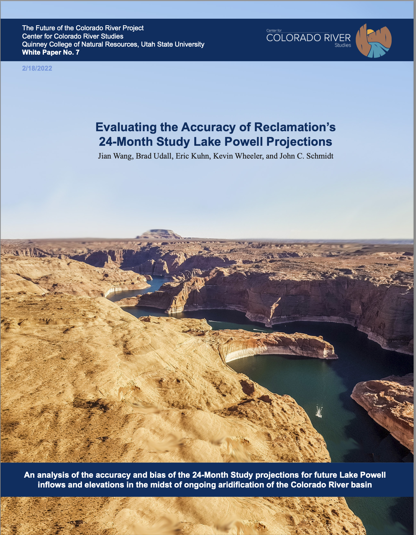
1. The ‘24 Month Study,’ the Bureau of Reclamation’s monthly-issued forecasting report for elevations at Lake Powell and other reservoirs, relies on two very different estimation techniques that are applied to the first year of the forecast window and to the second year. Projections for reservoir elevations during the next few months are based on predictions of reservoir inflow using a widely accepted watershed hydrologic model run by the Col- orado Basin River Forecast Center. The input data for that model are observed snowpack in the watershed, soil moisture, and anticipated precipitation and temperature. Projections for reservoir elevations beyond the imme- diately proximate winter, a year or more in the future (‘second year projections’), are based on statistical probabilities calculated using analyses of past inflows during a 30-year reference period. Reclamation issues three different forecasts using three different inflows called Maximum Probable, Most Probable and Minimum Probable.
2. Analyses of past inflows use a 30-year reference period that is updated each decade. Until recently, that reference period was the estimated unregulated flows that occurred between 1981-2010. In fall 2021 the reference period was updated to the 1991-2020 period. The medi- an annual inflow from the earlier 1981-2010 reference period was higher than more recent periods—3% higher than the updated reference period and 9% higher than the unregulated inflows that have occurred since onset of the Millennium Drought. Our analysis of the accuracy and bias of second-year projections made in the 24 Month
Studies issued from 2010-2021 demonstrates that the most probable projected inflows were higher than what actually occurred by as much as ~7 million acre feet (maf) in some years, and predicted reservoir elevations were also higher than what occurred in some years.
3. During the years when the 1981-2010 reference period was used for forecasting (prior to fall 2021), the driest conditions of the Millennium Drought were not well anticipated or predicted until January of the year being forecast. In the very driest year, inflow predictions were consistently high until the entire snowmelt runoff season had ended. Multi-year periods of very low inflow were also not well predicted by projections based on the 1981-2010 reference period. These multi-year periods of very low inflow are a significant risk to sustainable water-supply management during the on-going Millen- nium Drought.
4. The accuracy of the first year of the forecast window improves as the winter progresses, and the uncertainty of the projections of reservoir inflow is reduced. However, there remains some uncertainty for inflow projections in the first year of the forecast window, because precipitation and temperature during the last months of winter and spring are also based on the statistical probabilities derived from the 30-year reference period.
5. During years 2010-2021, the Most Probable August 24-Month Study (used for determining the Lake Powell Operation tier for the upcoming year), tended to overestimate the end-of-calendar-year Lake Powell elevation by as much as ~10 feet. The September 24-Month Study came closer to the mark, and was within ~5 feet of what actually occurred. Similarly, the April forecast, used for adjusting the Lake Powell Operation tier in the middle of the water year, either overestimated or underestimated the actual end-of-water-year elevation by as much as 20 feet. The uncertainty of the May forecast was reduced to +/- 10 feet. From an accuracy perspective, the September and May forecasting reports are more accurate tools for determining and adjusting Lake Powell operation tiers than are the August or April estimates.
6. The bias for inflow predictions will likely be reduced now that the reference period includes a more recent, and somewhat drier, span of time, but projections of future inflows are likely to remain biased, because the hydrology of the 1991-2020 reference period was still wetter than the current Millennium Drought. These findings are consistent with Kuhn’s (2021) observation that the hydrology used in the 24 MS does not fully capture the risks of ongoing aridification of the Colorado River basin and that wa- ter-supply planning ought to better anticipate the risks of decreasing inflows to Lake Powell.
This is the seventh in a series of white papers from the Future of the Colorado River Project.
Ron Rogers biologist with Bio-West Inc., holds a large razorback sucker captured in Lake Mead near the Colorado River inflow area
Click the link to read the article on The Durango Herald (Aedan Hannon). Here’s an excerpt:
Hickenlooper, D-Colo., and Sen. Mitt Romney, R-Utah, introduced the Upper Colorado and San Juan River Basins Recovery Act in the Senate on Thursday to bolster the Upper Colorado River Endangered Fish Recovery and San Juan River Basin Recovery Implementation programs. The legislation would extend the two programs by one year and give communities more time to develop long-term management plans for the fish species they protect…
Humpback chub
A Colorado pikeminnow taken from the Colorado River near Grand Junction, and in the arms of Danielle Tremblay, a Colorado Parks and Wildlife employee. Pikeminnows have been tracked swimming upstream for great distances to spawn in the 15-mile stretch of river between Palisade and Grand Junction. An apex predator in the Colorado, pikeminnows used to be found up to six feet long and weighing 100 pounds. Photo credit: Lori Martin, Colorado Parks and Wildlife via Aspen Journalism
Wild bonytail chub
Ron Rogers biologist with Bio-West Inc., holds a large razorback sucker captured in Lake Mead near the Colorado River inflow area
The Upper Colorado River Endangered Fish Recovery and San Juan River Basin Recovery Implementation programs aim to recover and protect four threatened and endangered fish species: humpback chub, bonytail, Colorado pikeminnow and razorback sucker…
The Upper Colorado River Endangered Fish Recovery and San Juan River Basin Recovery Implementation programs were established in the late 1980s and early 1990s with cooperative agreements between public land agencies, states, tribes and other stakeholders…
The decadeslong conservation efforts have largely been successful with the U.S. Fish and Wildlife Service recommending the downlisting of the razorback sucker and humpback chub from endangered to threatened in 2018.
But the added threat of climate change could affect these fish populations, with the razorback sucker, Colorado pikeminnow and bonytail still reliant on active management from the agencies and their partners.
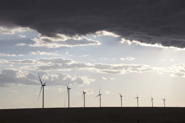
A turbine whirls on a farm east of Burlington, Colo. Colorado’s eastern plains already have many wind farms—but it may look like a pin cushion during the next several years. Photo/Allen Best
This issue is rich with content about our giant energy pivot underway in Colorado and beyond, the one made necessary—despite the cold and snow today—of the climate crisis.
In this issue are 15 stories, from Lamar to Craig, some short and some long, about transmission lines loping across eastern Colorado’s wind-swept prairies, La Plata Energy’s “monumental” pivot in southwestern Colorado; batteries and buildings in Aspen, and other topics. Some are already posted at http://BigPivots.com; others will be soon.
Also in this issue is a story about Comanche 3, which is down—again. Will this coal plant, still a relative youngster, remain standing to 2034, even with reduced operations? It sure looks like a stranded asset.
How will coal-dependent towns and cities transition to life beyond? The proponent of a nuclear study made the case to a Colorado legislative committee this week that modular nuclear reactors can help Colorado achieve 100% emissions-free electricity while easing those coal communities to a life beyond. Be assured, all the answers in this energy pivot have not arrived, as that state senator observed.
Now a question before state regulators is how best to avoid stranded assets as we nudge emissions from fossil fuels burned for heating and other purposes in buildings. The 2021 laws requiring this are relatively clear, but the precise pathway far from certain. PUC commissioners, led by Megan Gilman, have been asking good questions as they conferred with representatives of utilities, unions, and others engaged in creating solutions.
Sparking the most interest is the proposal to end the subsidies for extension of natural gas lines. Right now, if you live in a new subdivision, you’re not paying the full cost of the extension of the natural gas line. It’s being financed by existing customers. The cost is socialized. This is a hot issue—and will get hotter. The optics on this are really, really interesting. Boulder argues against socialism and Grand Junction argues for it (along with Aurora, by the way). Some of this will be hashed out in a special day-long session of the PUC on March 7.
Meanwhile, we have a $24-$25 million natural gas line proposed to the Sloans Lake area west of downtown Denver that, under normal depreciation schedules, will not be paid off until after 2050—when Colorado’s economy is supposed to be substantially decarbonized.
Comanche 3 was approved 18 years ago, and we’re 28 years away from that decarbonization target.
Do trust Big Pivots to keep following this and other conversations.
Also, I ask you respectfully to encourage others to join the “subscription list by signing up here. Want off this mailing list for Big Pivots? Let me know.
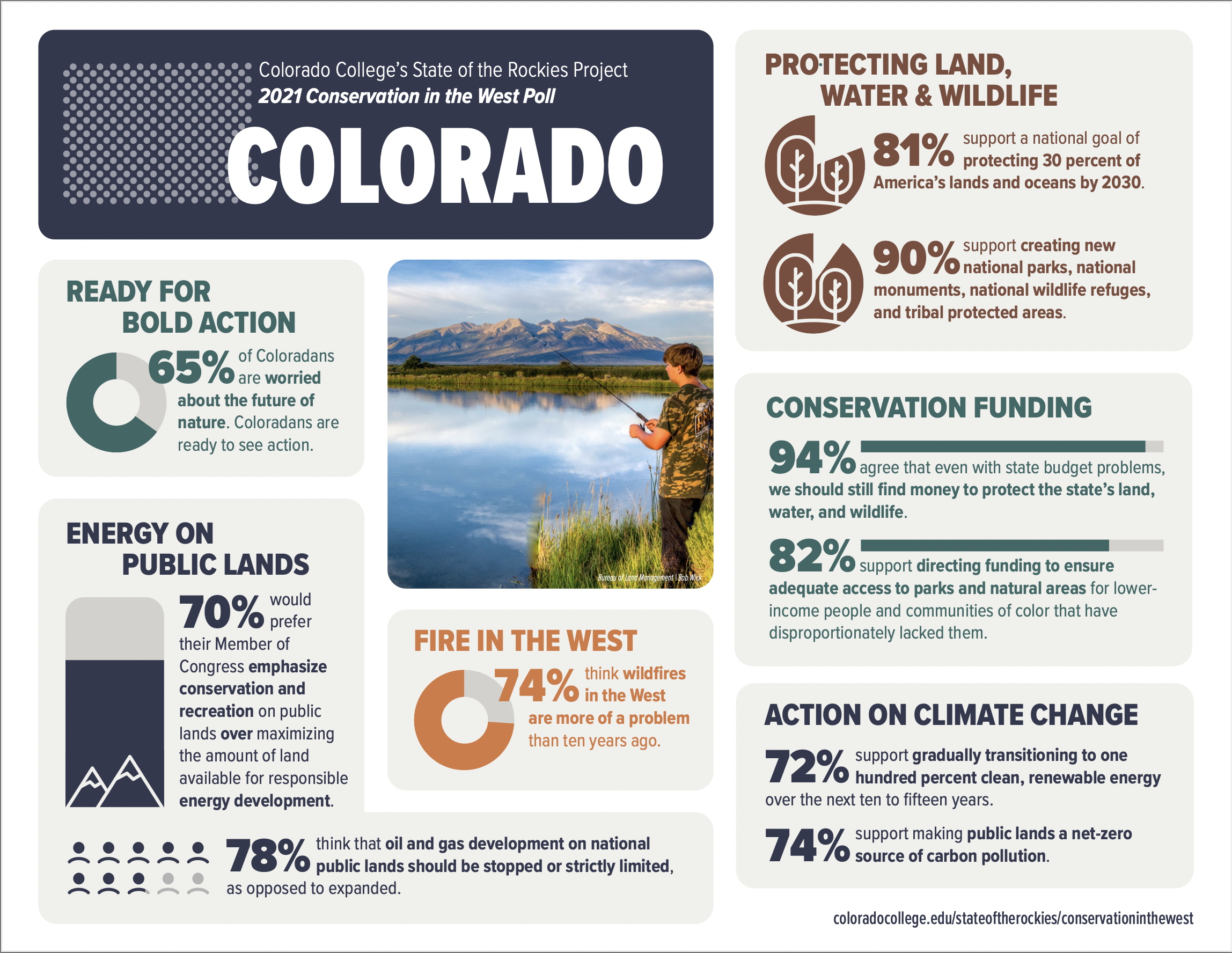
Twelfth annual Conservation in the West Poll reveals strong support for policies to protect more outdoor spaces
Colorado College’s 12th annual State of the Rockies Project Conservation in the West Poll released today showed a spike in concern over issues like drought, inadequate water supplies, wildfires, the loss of wildlife habitats and natural spaces, and climate change among voters in the Mountain West. Those concerns align with continued strong support for pro-conservation policies.
The poll, which surveyed the views of voters in eight Mountain West states (Arizona, Colorado, Idaho, Montana, Nevada, New Mexico, Utah, and Wyoming), found 69 percent of voters are concerned about the future of nature, meaning land, water, air, and wildlife. That level of concern was a notable jump from 61 percent in last year’s poll. Against that backdrop, 86 percent of Western voters now say issues involving clean water, clean air, wildlife and public lands are important in their decision of whether to support an elected official, up from 80 percent in 2020 and 75 percent in 2016.
“We are seeing a perfect storm of threats that are driving higher levels of concern than ever before for the state of our lands and water in the Mountain West,” said Katrina Miller-Stevens, Director of the State of the Rockies Project and an associate professor at Colorado College. “Not surprisingly, most voters are aligning behind policies that would help mitigate threats by conserving and protecting more outdoor spaces.”
After the climb out of Coyote Gulch at Jacob Hambiln Arch (2000).
Consistent with prior year results, voters in the Mountain West feel deeply connected to the outdoor landscapes that surround them. 88 percent of voters surveyed report at least one visit to national public lands like national parks, national forests, national monuments, and national wildlife refuges in the past year. Similarly, 93 percent report participating regularly in outdoor recreation activities such as hiking, camping, picnicking, bird and wildlife watching, biking, water sports, snow sports, hunting, and fishing. 74 percent say the presence of public lands in their state helps the local economy.
At the same time, 48 percent of voters report making changes to where or when they recreate outdoors because of crowding and 26 percent adjusted plans because of changes in climate like fires, less snow, or less water. 53 percent of voters view the loss of natural areas as a very or extremely serious problem, up from 44 percent in 2020 and 36 percent in 2011.
Ranking and time evolution of summer (June–August) drought severity as indicated by negative 0–200 cm soil moisture anomalies. Maps show how gridded summer drought severity in each year from 2000–2021 ranked among all years 1901–2021, where low (brown) means low soil moisture and therefore high drought severity. Yellow boxes bound the southwestern North America (SWNA) study region. Time series shows standardized anomalies (σ) of the SWNA regionally averaged soil moisture record relative to a 1950–1999 baseline. Black time series shows annual values and the red time series shows the 22-year running mean, with values displayed on the final year of each 22-year window. Geographic boundaries in maps were accessed through Matlab 2020a.
Climate change seen as a threat with voters expressing concern over impacts
Most voters in the Mountain West, 62 percent, believe climate change is happening and requires action. Among them, 44 percent agree climate change is established as a serious problem and immediate action is necessary. Another 18 percent say there is enough evidence of climate change that some action should be taken. 52 percent of voters view climate change as a very serious or extremely serious problem, up from 46 percent in 2020 and 27 percent in 2011.
Voters express heightened concern about impacts commonly associated with climate change.
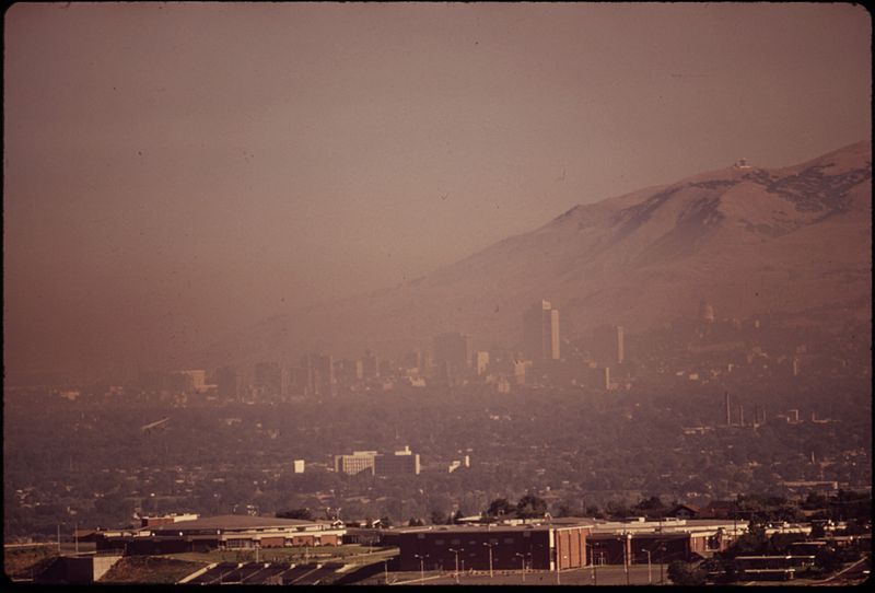
Smog blankets Salt Lake City. Photo credit Wikimedia Commons.
79 percent are concerned about worse air quality due to ozone and smoke.
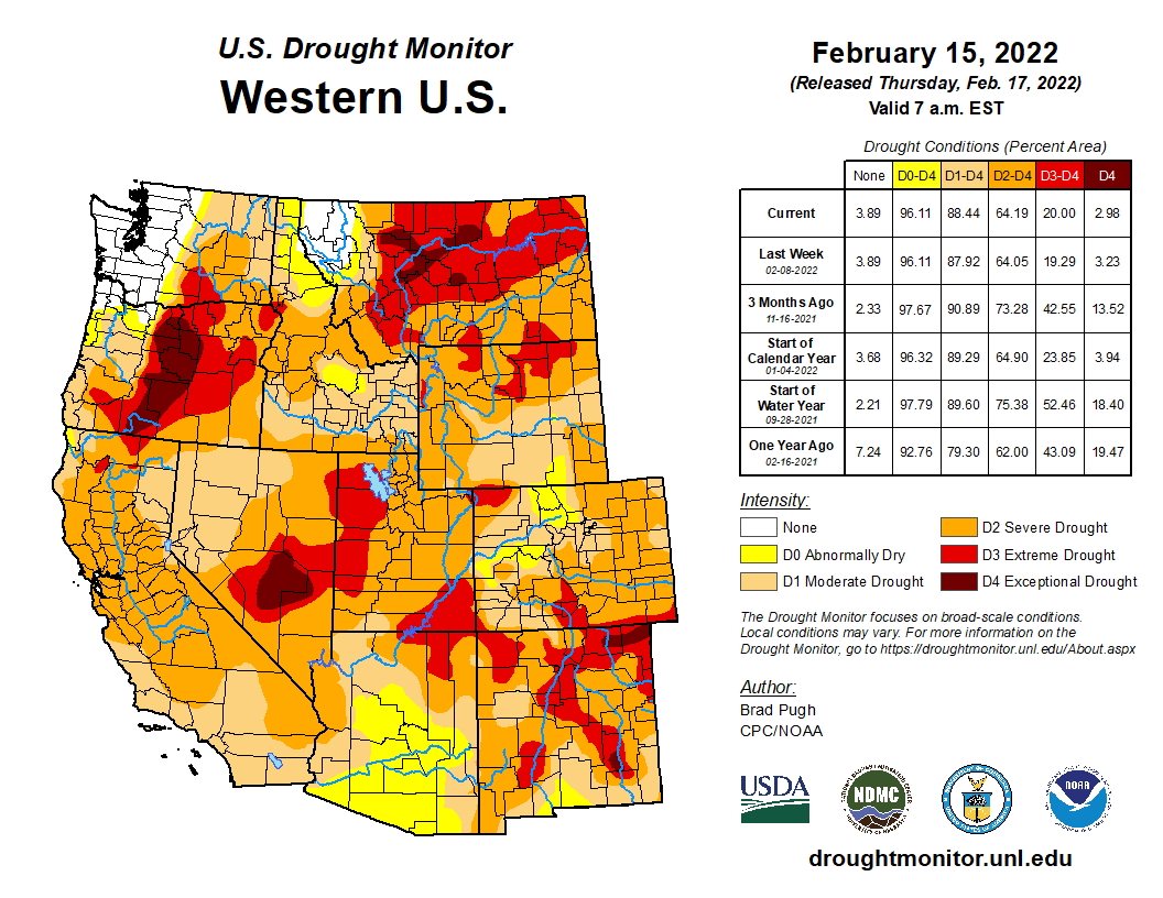
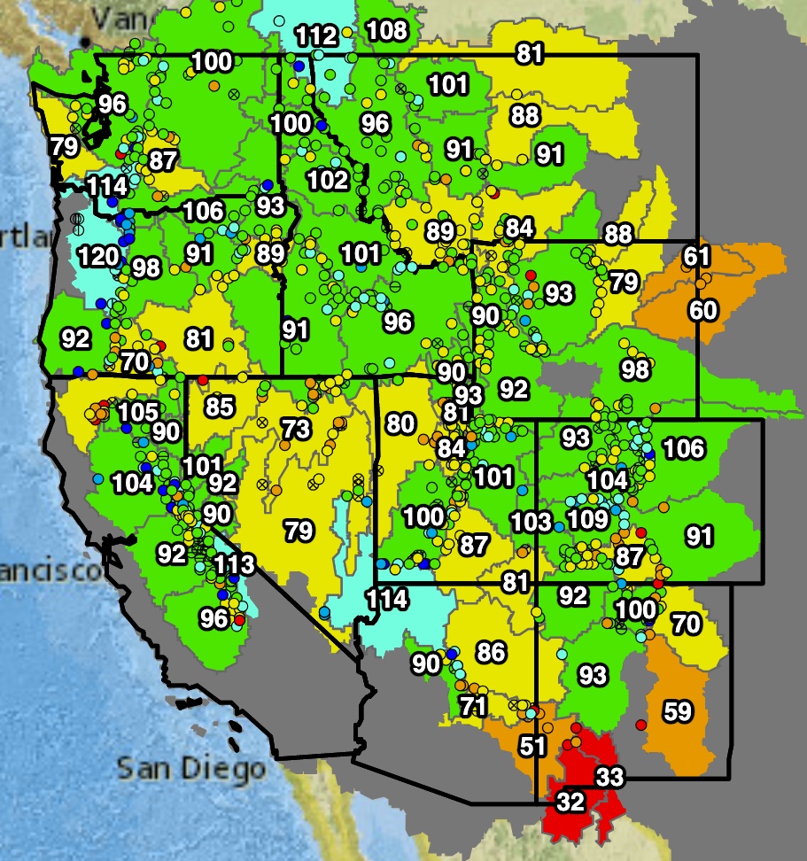
West Drought Monitor map February 15, 2022.
86 percent are concerned about droughts and reduced snowpack.
Glenwood Canyon and the Colorado River. Photo credit: CDOT via Roads & Bridges
61 percent are concerned about extreme weather events like intense storms or floods.
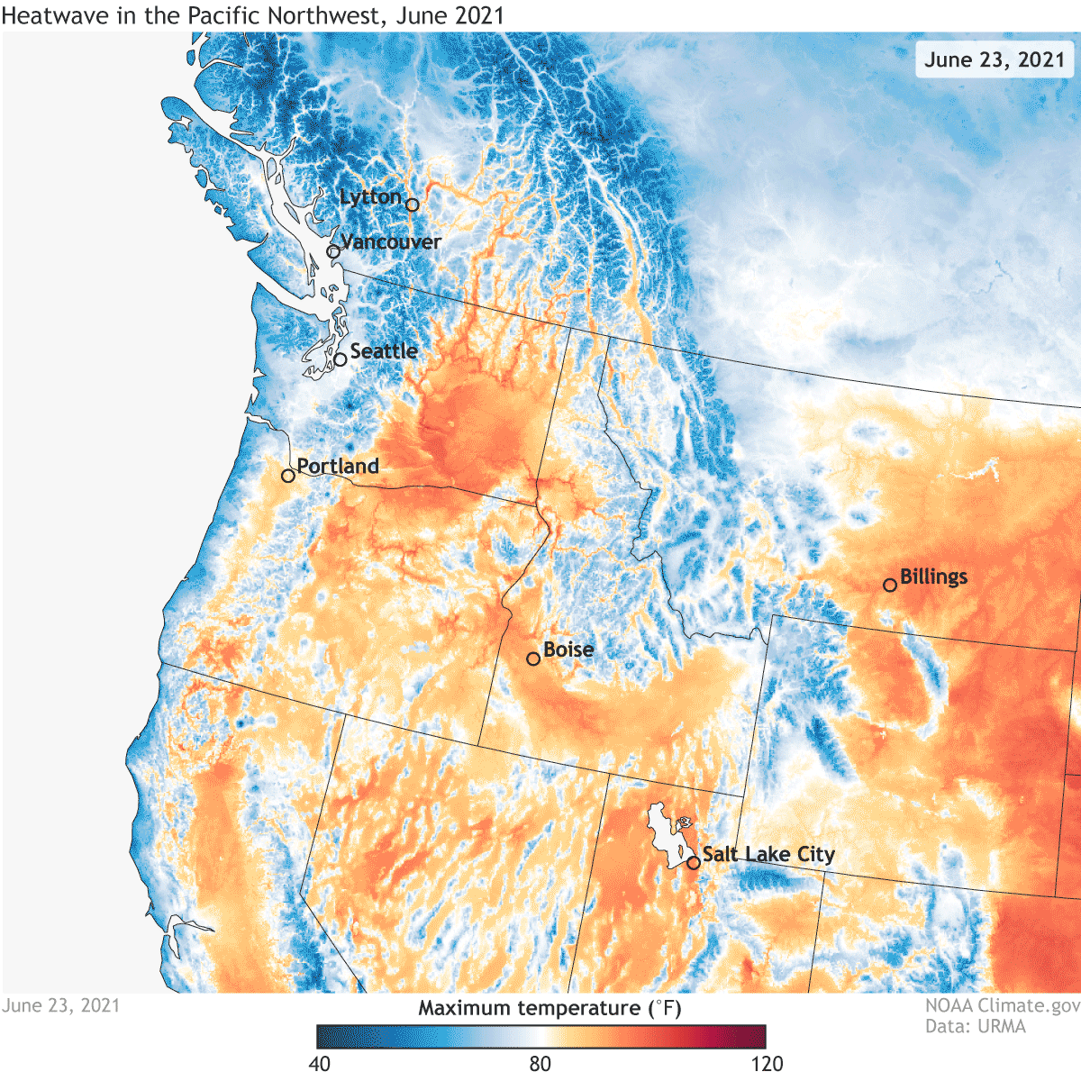
Daytime high temperatures across the western United States on June 23-28, 2021, according to data from NOAA’s Real-Time Mesoscale Analysis/URMA. Climate.gov animation based on NOAA URMA data.
69 percent are concerned about extreme heat.
The East Troublesome Fire burns in Grand County in October 2020. Credit: Northern Water
82 percent are concerned about more frequent and severe wildfires.
Marshall Fire December 30, 2021. Photo credit: Boulder County
62 percent say uncontrollable wildfires that threaten homes and property are a very or extremely serious problem, up from 47 percent in 2020 and 32 percent in 2016.
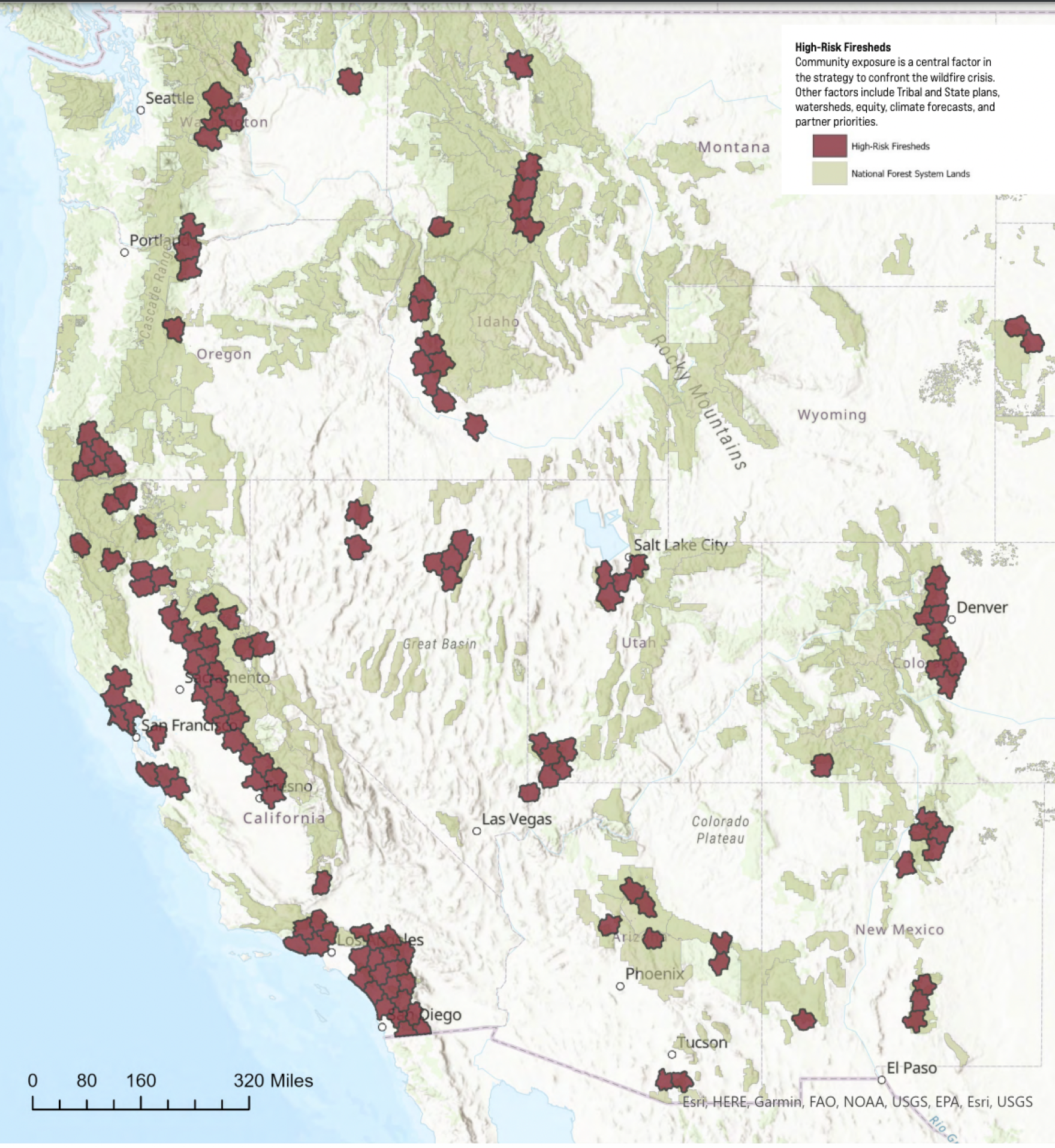
USFS highest risk firesheds January 2022.
70 percent say wildfires are more of a problem than ten years ago.
Continued super-majority support for conservation and access efforts
Westerners’ heightened concerns about climate change and its impacts are matched with strong consensus behind proposals to conserve and protect the country’s outdoors.
Photo credit: The Nature Conservancy
77 percent support setting a national goal of conserving thirty percent of land and inland waters in America, and thirty percent of its ocean areas by the year 2030.
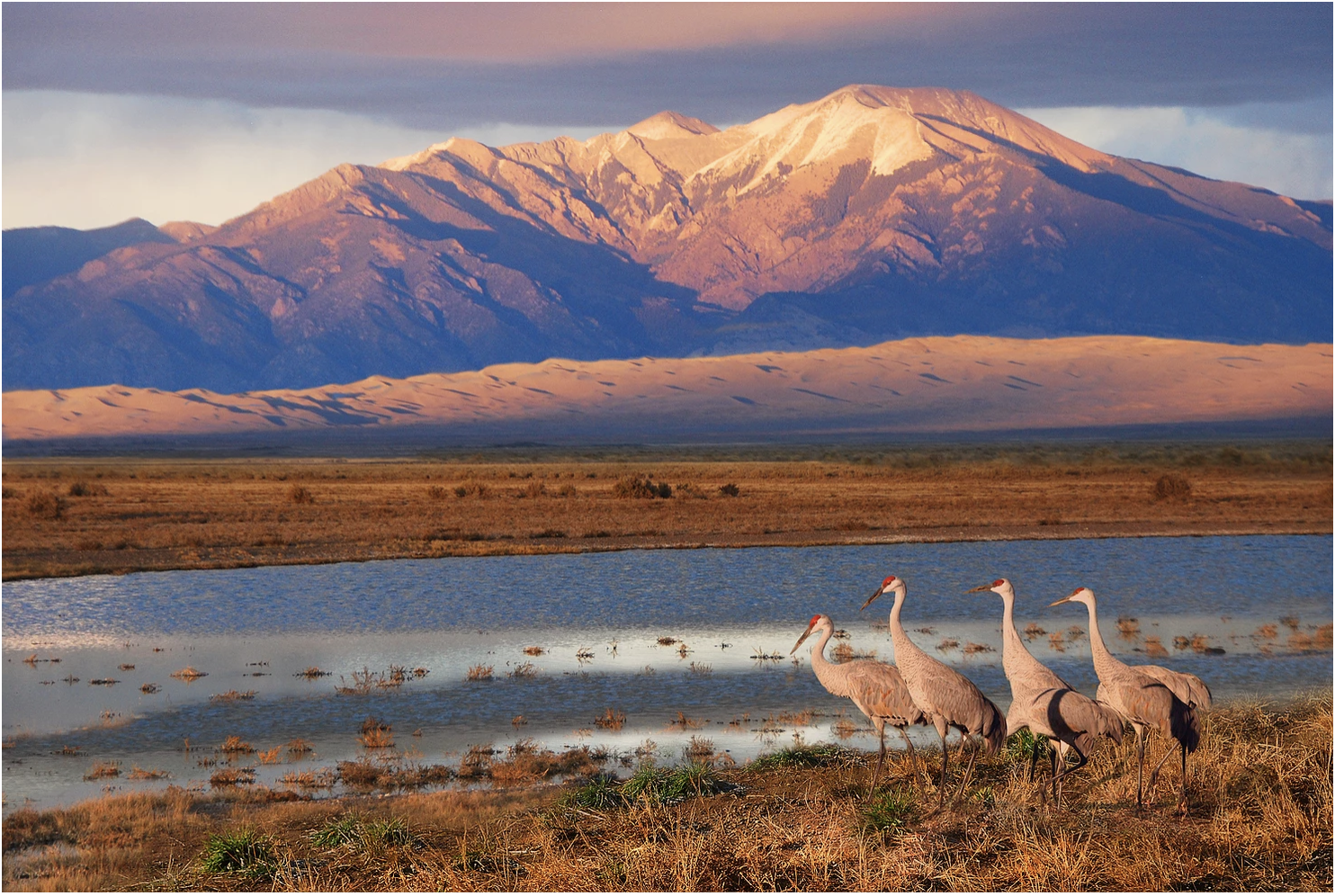
Sandhill Cranes West of Dunes by NPS/Patrick Myers
80 percent support creating new national parks, national monuments, national wildlife refuges and tribal protected areas to protect historic sites or areas for outdoor recreation.
The water replenishing the delta takes a circuitous path. A maze of irrigation infrastructure and long-neglected side channels delivers water to the 160-acre El Chaussé habitat restoration site, located 45 miles south of the U.S.-Mexico border in Baja California, and to downstream river segments. Photo: Claudio Contreras Koob
91 percent support addressing the backlog of infrastructure repairs, reducing risk of wildfires, and natural resource protection on national public lands such as national parks by providing jobs and training to unemployed people.
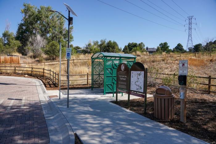
Arapahoe County Open Spaces opened a new trailhead on South Quebec Way in southeast Denver. The site includes parking, a bathroom, a trash can and a trail map. Adding new trailheads is major goal of the High Line Canal Conservancy to improve access and facilities for the public. Photo credit: Denver Water.
81 percent support providing funding to ensure more communities, especially those that have historically lacked access, have safe and nearby parks and natural areas.
The Dolores River, below Slickrock, and above Bedrock. The Dolores River Canyon is included in a proposed National Conservation Area. Photo: Brent Gardner-Smith/Aspen Journalism.
Locally, a variety of proposed conservation efforts are popular with in-state voters. In Arizona, 61 percent of voters support legislation to make permanent the current ban on new uranium and other mining on public lands surrounding the Grand Canyon. 89 percent of Coloradans agree with protecting existing public lands surrounding the Dolores River Canyon to conserve important wildlife habitat, safeguard the area’s scenic beauty, and support outdoor recreation. 79 percent of Montanans support enacting the Blackfoot Clearwater Stewardship Act to ensure hunting and fishing access, protect stream flows into the Blackfoot River and add eighty thousand acres of new protected public lands for recreation areas, along with timber harvest and habitat restoration. In New Mexico, 73 percent of voters want to designate existing public lands in the Caja del Rio plateau as a national conservation area to increase protections for grasslands and canyons along the Santa Fe river and other smaller rivers flowing into the Rio Grande. 79 percent of Nevadans want to designate existing public lands in southern Nevada as the Spirit Mountain National Monument to ensure outdoor recreation and help preserve sacred Native sites. In Utah, 60 percent of voters call President Biden’s restored protections for over a million acres of the Bears Ears National Monument “more of a good thing.”
Spike in water issues viewed as very and extremely serious problems
The level of concern among Westerners around water issues spiked in this year’s poll. Water issues viewed as very serious or extremely serious problems by voters include drought (73 percent, up from 52 percent in 2016) low levels of water in rivers (73 percent, up from 55 percent in 2020), inadequate water supplies (71 percent, up from 45 percent in 2020), and pollution in rivers, lakes and streams (56 percent, up from 42 percent in 2011).
Those concerns translate into strong support for water conservation efforts aimed at addressing water shortage situations in the future by voters in Arizona, Colorado, Nevada, New Mexico, Utah and Wyoming. 81 percent prefer using water supplies more wisely by encouraging more water conservation, reducing use, and increasing water recycling. By contrast, 14 percent would rather divert more water from rivers in less populated areas of the state to communities where more people live.
Asked about remote locations, 87 percent of voters across the survey support increasing federal funding to extend running water and sanitation services to rural areas and tribal communities that currently lack access.
Voters seeking a cleaner and safer energy future on public lands
With oil and gas drilling taking place on half of America’s public lands, Western voters are familiar with the harmful impacts and want to ensure their public lands are protected and safe. 43 percent of voters view the impacts of oil and gas drilling on land, air and water as an extremely or very serious problem.
Turning to solutions, 91 percent of voters support requiring oil and gas companies to use updated equipment and technology to prevent leaks of methane gas and other pollution into the air. 91 percent of voters support requiring oil and gas companies, rather than federal and state governments, to pay for all of the clean-up and land restoration costs after drilling is finished. On compensating the public for extraction, 65 percent of voters support increasing the fees that oil and gas companies pay to have the opportunity to drill on national public lands.
Voters in the Mountain West prefer clean sources of energy. 66 percent of voters support gradually transitioning to one hundred percent of our energy being produced from clean, renewable sources like solar and wind over the next ten to fifteen years. Asked which sources of energy they want encouraged in their state, solar power and wind power top the list at 61 percent and 37 percent, respectively.
Given a choice of public lands uses facing lawmakers, 67 percent of voters prefer ensuring we protect sources of clean water, air quality and wildlife habitat while providing opportunities to visit and recreate on national public lands. By contrast, 28 percent of voters would rather ensure we produce more domestic energy by maximizing the amount of national public lands available for responsible oil and gas drilling and mining.
Nearly three-fourths of Western voters want to significantly curb oil and gas development on public lands. 55 percent think that oil and gas development should be strictly limited on public lands and another 15 percent say it should be stopped completely. That is compared to 28 percent of voters in the West who would like to expand oil and gas development on public lands. That is compared to 28 percent of voters in the West who would like to expand oil and gas development on public lands.
Black, Latino and Native American voters support conservation at higher levels
For the second consecutive year the poll examined the intersection of race with views on conservation priorities. Results were separated by responses from Black, Latino, and Native American voters, along with combined communities of color findings. The poll included an oversample of Black and Native American voters in the region in order to speak more confidently about the view of those communities.
The poll found notably higher percentages of Black voters, Latino voters, and Native American voters to be concerned about climate change, pollution of rivers, lakes, and streams, and the impact of oil and gas drilling on our land, air, and water. The poll also found higher levels of support within communities of color for bold conservation policies like protecting 30 percent of the country’s lands and waters by 2030, establishing more national public lands and transitioning to one hundred percent renewable energy. Large majorities of Black voters, Latino voters, and Native American voters also believe in climate change and want to see action on it at even higher levels than the overall survey sample.
This is the twelfth consecutive year Colorado College gauged the public’s sentiment on public lands and conservation issues. The 2022 Colorado College Conservation in the West Poll is a bipartisan survey conducted by Republican pollster Lori Weigel of New Bridge Strategy and Democratic pollster Dave Metz of Fairbank, Maslin, Maullin, Metz & Associates. The survey is funded by the William and Flora Hewlett Foundation.
The poll surveyed at least 400 registered voters in each of eight Western states (AZ, CO, ID, MT, NV, NM, UT, & WY) for a total 3,400-voter sample, which included an over-sample of Black and Native American voters. The survey was conducted between January 5-23, 2022 and the effective margin of error is +2.4% at the 95% confidence interval for the total sample; and at most +4.8% for each state. The full survey and individual state surveys are available on the State of the Rockies website.
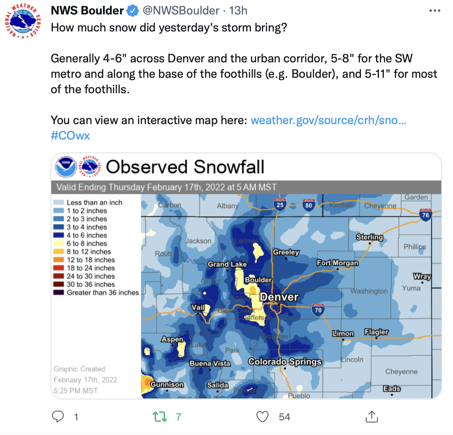
Click the link to read the article on the Fort Collins Coloradoan (Miles Blumhardt). Here’s an excerpt:
Fort Collins generally received 4 to 5 inches of snow, with one reporting station 5.4 miles west-southwest of the city’s main reporting station on the Colorado State University campus reporting 6.5 inches, according to the weather service and Community Collaborative Rain, Hail and Snow Network stations…
Colorado snowfall totals
Golden: (1.6 miles southwest): 10.4 inches
Boulder (3 miles northwest): 7.6 inches
Boulder (1.5 miles north-northwest): 6.8 inches
Fort Collins (5.4 miles west-southwest): 6.5 inches
Estes Park: 6.5. inches
Horsetooth Mountain (2 miles south-southeast): 5.5 inches
DIA: 5 inches
Fort Collins (2.1 miles southwest): 4.9 inches
Poudre Park: 4.8 inches
Fort Collins (2.8 miles west): 4.7 inches
Denver (2.1 miles east-southeast): 4.5 inches
Vail (2.6 miles east): 4.5 inches
Fort Collins (2.5 miles northwest): 4.3 inches
Fort Collins (0.7 miles south-southwest): 4.1 inches
Laporte (1.4 miles northwest): 4 inches
Loveland: (2.4 miles west): 4 inches
Timnath (2.1 miles east): 3.7 inches
Loveland: (4.8 miles southeast): 3.5 inches
Longmont: 3.5 inches
Greeley: (1 mile south): 2.6 inches
Severance: 2.6 inches
Fort Collins (4.6 miles north): 2.5 inches
Wellington: 2 inches
Click the link to read the article on Big Pivots (Allen Best):
Tim Wheeler may have had the best line among the directors of La Plata Electric Association after they unanimously approved a resolution that firmly puts them on a path to a half-a-loaf arrangement with their current electrical provider, Tri-State Generation and Transmission.
Even in the 1990s, he explained, he had begun asking why they couldn’t provide more electrical generation locally in a way that could lead to a lower cost and with a greater benefit to the existing climate.
“I am very mindful of people who told me along the way for 25 yeas that this couldn’t be done,” he said. “I want to thank them for being wrong.”
The case for the new arrangement was laid out in a video-conference town hall held by La Plata last week.
La Plata’s existing contract with Tri-State allows the Durango-based cooperative to generate just 5% of its own power. Under a new contract approved conceptually in October 2020 by Tri-State’s members, individual members will be able to provide up to 50% of their own electricity, either through their own generation or purchases from others.
In this case, La Plata is eyeing a contract with Crossover Energy Parnters, a relatively new energy supplier financed by the Wall Street firm KKR. Crossover would provide 71 megawatts of generation and Tri-State 71 megawatts.
Dan Harms, the vice president of grid solutions for La Plata, said the cooperative and Tri-State have agreed to a final partial contract payment arrangement that will be submitted to the Federal Energy Regulatory Commission for approval. Because of the sensitivity of the negotiations, he said, details could not be divulged.Dan Harms.
La Plata hopes to enter this new 50-50 future beginning January 2024, he said. If this happens—the deal still isn’t final—then La Plata will immediately reduce its carbon footprint 50%.
Why a partial-requirements contract instead of a full buyout? Harms cited several reasons. It meets La Plata’s climate goal, which is to decarbonize 50% by 2030 as compared to 2018. It also uses Tri-State’s transmission infrastructure that will allow La Plata to tap Tri-State’s more regional generational resources.
By staying with Tri-State on a half-time basis, though, La Plata avoids some of the headaches of being a solo operator, he said, if not in quite as many words. A full buy-out would require La Plata to cover costs of regulatory compliance, transmission access and other elements.
“With partial buyout, we still have access to a lot of the benefits and services that Tri-State provides,” he said.
The case for a partial
The most compelling evidence in the hour-long session was a chart (see top) showing costs of a full vs. a partial buyout. That chart showed much larger savings from the partial requirements.
The partial requirements contract will save La Plata $7 million a year.
Given that La Plata currently spends $68 million buying electricity, even 1% cut can make a big difference, Harms said.
None of the options are off the table permanently. It can go to a full exit later, said Harms.
The coop’s existing all-requirements contract was approved in 2006, a time when most coop directors could not envision the rapid dive of renewable prices.
La Plata began showing discontent with its contract with Tri-State in 2017. In early 2018 it began investigating its alternatives. It formally notified Tri-State later that year what it was up to and also asked what it would cost to get out of its contract.
Kit Carson Electric, a member in New Mexico, had left in 2016 after paying $37 million. Delta-Montrose Electric, a Colorado member, was then negotiating with Tri-State for its exit, which later was tabulated at $62 million. And United Power had also indicated it wanted to explore options.
The Colorado Public Utilities Commission likely would have determined the exit fee for La Plata had not Tri-State, by then under the leadership of Duane Highley, used a legal strategy to move such deliberations to FERC, the federal agency in Washington D.C. Much of this legal shuffling occurred during the dark of the covid lockdowns in 2020.
Tri-State has submitted methodologies for determining both buy-downs and buy-outs. They’re called and buy-down payments (PDPs) and contract-termination payments (CTP). FERC has not yet approved either methodology.
Mark Pearson, of the Durango-based San Juan Citizens Alliance, called the partial buy-out “a great step forward.”
“It’s a great way for us to accelerate our transition to a much less carbon-intensive electricity supply, and hopefully all 50% of La Plata’s generation will be local renewable energy,” he said. He also sees value in exploring the benefits of a full buyout, once that methodology has been approved by FERC.
Lee Boughey, communications officer for Tri-State, said he expects FERC to conduct a hearing on the contract termination methodology in May. He said Tri-State directors will not need to take any additional actions on this or other partial requirements contracts filed with FERC.
Tri-State last year announced a pool of 300 megawatts of generation available to its 42 member cooperatives. Three of the coops bid in what Tri-State calls the open season, La Plata among them. The other two were not identified. Tri-State will conduct another open-season in May.
Tri-State looks like a very different electrical supplier than it was in 2017. Then, it was still dragging its feet on embracing changes. La Plata was itching to make them.
Duane Highley via The Mountain Town News
Since Duane Highley arrived as chief executive in April 2019, Tri-State has promised to achieve 70% renewables in the electricity it delivers in Colorado by 2030. That’s an 80% reduction compared to 2005 levels.
The wholesale provider has also stopped raising rates and is now lowering them, 2% last year with another 2% reduction schedule for this fall. It is working with La Plata to install a 2-megawatt community solar project.
At the same time, it has failed to placate its single largest member, Brighton-based United Power, which has 105,000 members, nearly twice as many a La Plata. In December, United announced it had made up its mind. It wants out—and Mark Gabriel, the chief executive, said at a recent conference that he’s counting the days.
The precise numbers of this partial buy-down have not been revealed, which is likely what directors and chief executives at other cooperatives will want to see. At least six others have indicated they are studying their options.
What’s in this for Tri-State? Even after Highley arrived, the wholesale provider seemed to be desperate to hold onto members. The initial buy-outnumbers [Tri-State] provided La Plata and United Power were preposterous.
Pat Bridges, a senior vice president and chief financial officer at Tri-State, said at the town hall meeting last week that this agreements will be a win-win for Tri-State because the 50% contract will help it pivot from coal plants to renewables.
It will “actually allow us to move faster in that regard,” he said. There are upfront costs in the energy transition, he added.
Good questions 15 years ago
Win-win was also a phrase frequently used by board members in Durango on Wednesday.
Bob Lynch, a board member, called it a “monumental thing.” The board’s approval brings it “as close as you get without hooking up new power.”
Lynch also pointed to the changed leadership, both in the chief executives of La Plata and Tri-State, in moving the discussion along. “We have the right leaders in place.”
He also credited a former board member, Jeff Berman, with “starting the discussion and starting the argument” about green power.
Berman, who let the board 5 years ago, told Big Pivots that he listened for a couple of years during his 12 years on the board before he started asking basic questions about power sources, costs and alternatives. “It’s a shame it took 17 years, but better to move forward now and do it right,” he said.
He remains in Durango, having become a licensed engineer and is now “laser focused on actually building solar power and battery storage.”
Rachael Landis, a board member, pointed out that despite the national division and diversities among the directors themselves, they had thought critically about how to keep the best interests of La Plata customers in mind.
Joe Lewandowski shared that as recently as a year and a half ago, even after Tri-State had new leadership, he was discouraged. “It just didn’t look like we were going anywhere with Tri-State.” He, too, called it a win-win.
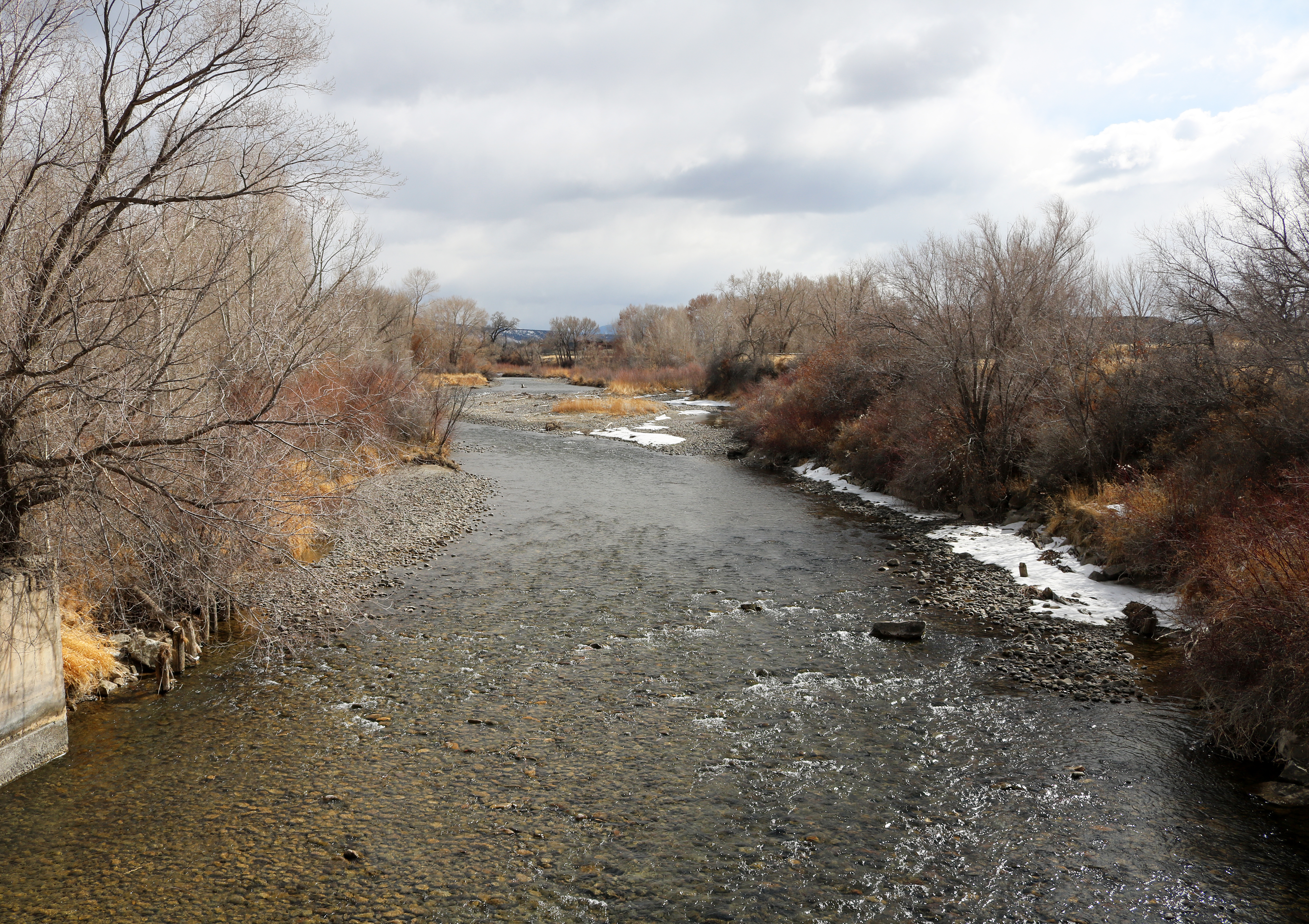
A powerful sprinkler capable of pumping more than 2,500 gallons of water per minute irrigates a farm field in the San Luis Valley June 6, 2019. Credit: Jerd Smith via Water Education Colorado
Colorado lawmakers have given initial approval to a bill that would provide millions of dollars to help two major water-short farm regions reduce water use and comply with legal obligations to deliver water to Kansas, Nebraska, Texas and New Mexico.
On Feb. 10 the Colorado Senate Agriculture & Natural Resources Committee unanimously approved [SB22-028 Groundwater Compact Compliance Fund: Concerning the creation of the groundwater compact compliance and sustainability fund] that creates a Groundwater Compact Compliance and Sustainability Fund to help pay to buy and retire farm wells and irrigated acreage in the Republican and Rio Grande basins in northeast and south-central Colorado. Colorado and federal tax revenue would bankroll the fund, and the Colorado Water Conservation Board would distribute the money based on recommendations from the Republican River Water Conservation District and the Rio Grande Water Conservation District, with approval by the state engineer.
The need
The fund is needed, according to proponents, to help reduce groundwater use that is depleting surface water flows in the Republican River and threatening Colorado’s ability to comply with a compact among Colorado, Kansas and Nebraska. It is also intended to help drought-stressed aquifers in the San Luis Valley recover and to meet aquifer sustainability standards required by the state in the Rio Grande Basin.
To achieve those goals, 25,000 acres of irrigated land must be taken out of production in the Republican basin, and 40,000 acres in the Rio Grande, by 2029. David Robbins, general counsel for both districts, noted that, “Both districts have received letters from the state engineer indicating that if they fail in the task they will receive orders shutting down the wells in each basin, which will have dramatic and very difficult consequences for everyone in both basins.”
The bill’s proponents hope to take advantage of a one-time funding opportunity—federal Covid-19 stimulus dollars under the American Rescue Plan Act of 2021 (ARPA). The General Assembly created the Economic Relief and Recovery Cash Fund last year to receive ARPA dollars and transferred nearly $850 million into it; investment in water infrastructure is among the eligible uses. It also established an Economic Recovery Task Force to recommend how to spend those funds. Sen. Cleave Simpson, R-Alamosa, who is also General Manager of the Rio Grande district and a co-sponsor of the bill, has requested $80 million from the task force to support the bill. The governor’s budget includes $15 million as a starting point.
Neither district is looking for a handout. The Republican has already assessed its water users $148.5 million to retire irrigated land, purchase or lease surface and groundwater, and pipe groundwater to the river near the Nebraska border to meet Colorado’s water delivery obligations. Aaron Sprague, a member of its board of directors, said the district had retired 42,000 acres of irrigated land since 2006 and thought they were in compliance, but then a court stipulation signed in 2016 by the three states, requiring 25,000 acres additional acres be retired, “effectively moved the goal posts on us.” The district has retired 3,000 acres of that additional land so far. Sprague figures the economic impact of well shutdowns to be $2.2 billion annually on local, regional and state economies.
Although the Rio Grande is also part of an interstate compact among Colorado, New Mexico and Texas, the issue there is reducing groundwater pumping to sustainable levels pursuant to state law. What constitutes sustainability is different in the shallow and deep aquifers that underlie the Rio Grande’s San Luis Valley, but it basically boils down to balancing inflows and outflows—precipitation, which averages less than 7” per year in that region, and return flows equaling groundwater withdrawals. As in the Republican basin, the Rio Grande district has taxed its farmers $69 million since 2006 to take irrigated land out of production and cut groundwater pumping, with 13,000 acres retired and well pumping reduced by a third in that period.
But 3,000 wells and 170,000 irrigated acres are at risk if the Rio Grande doesn’t meet the 2029 deadline. How would that affect the valley? Simpson emphasized that, “Irrigated agriculture in the San Luis Valley has about a $1 billion annual impact on our community…the culture, the economy were all built around it.”
The cost
So how much would it cost and where would the money come from? David Robbins suggests that each district would need at least $50 million “over and above” what they already have spent to achieve compliance. Sen. Jerry Sonnenberg, R-Sterling, another co-sponsor whose district includes the Republican River Basin, said he wasn’t sure $150 million total would be enough. “When commodity prices are where they are,” he noted, “it’s much more difficult to retire acres.” Corn now is selling at over $6/bushel, its highest level in years, making irrigated acreage more valuable.
The bill will go next to the Senate floor for debate. It has strong bipartisan support and is identical to a bill recommended by the interim Water Resources Review Committee last fall. But as Sen. Kerry Donovan, D-Vail, committee chair, pointed out, there is no appropriation attached. “This bill just creates an entity,” she cautioned, “and then we’ve got the real hard work to do of making sure we find money to put into it.”
Larry Morandi was formerly director of State Policy Research with the National Conference of State Legislatures in Denver, and is a frequent contributor to Fresh Water News. He can be reached at larrymorandi@comcast.net.
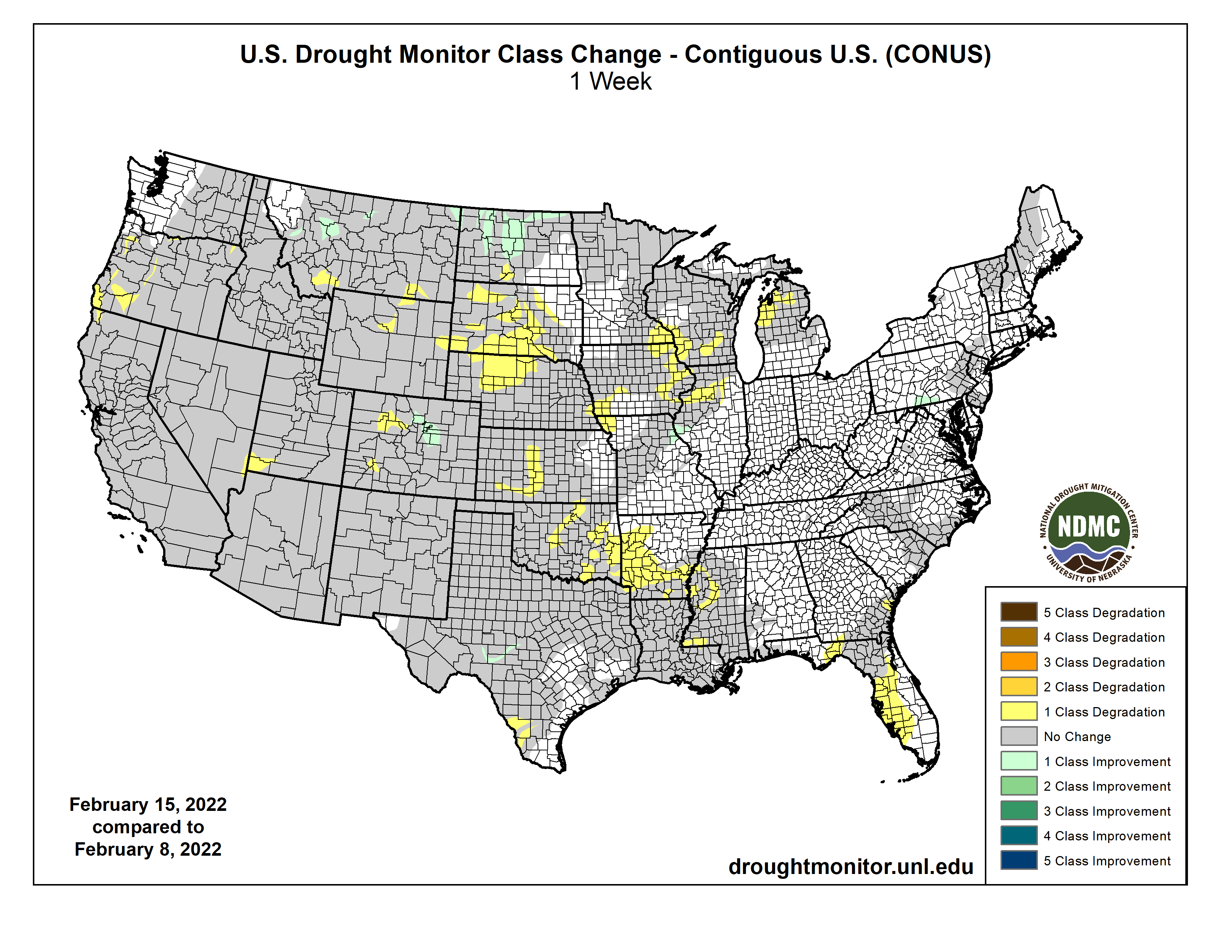
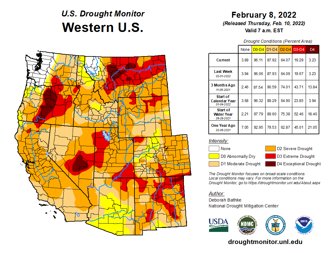
Click on a thumbnail graphic to view a gallery of drought data from the US Drought Monitor.
US Drought Monitor map February 15, 2022.
High Plains Drought Monitor map February 15, 2022.
West Drought Monitor map February 15, 2022.
Colorado Drought Monitor map February 15, 2022.
Click on the link to go to the US Drought Monitor website. Here’s an excerpt:
This Week’s Drought Summary
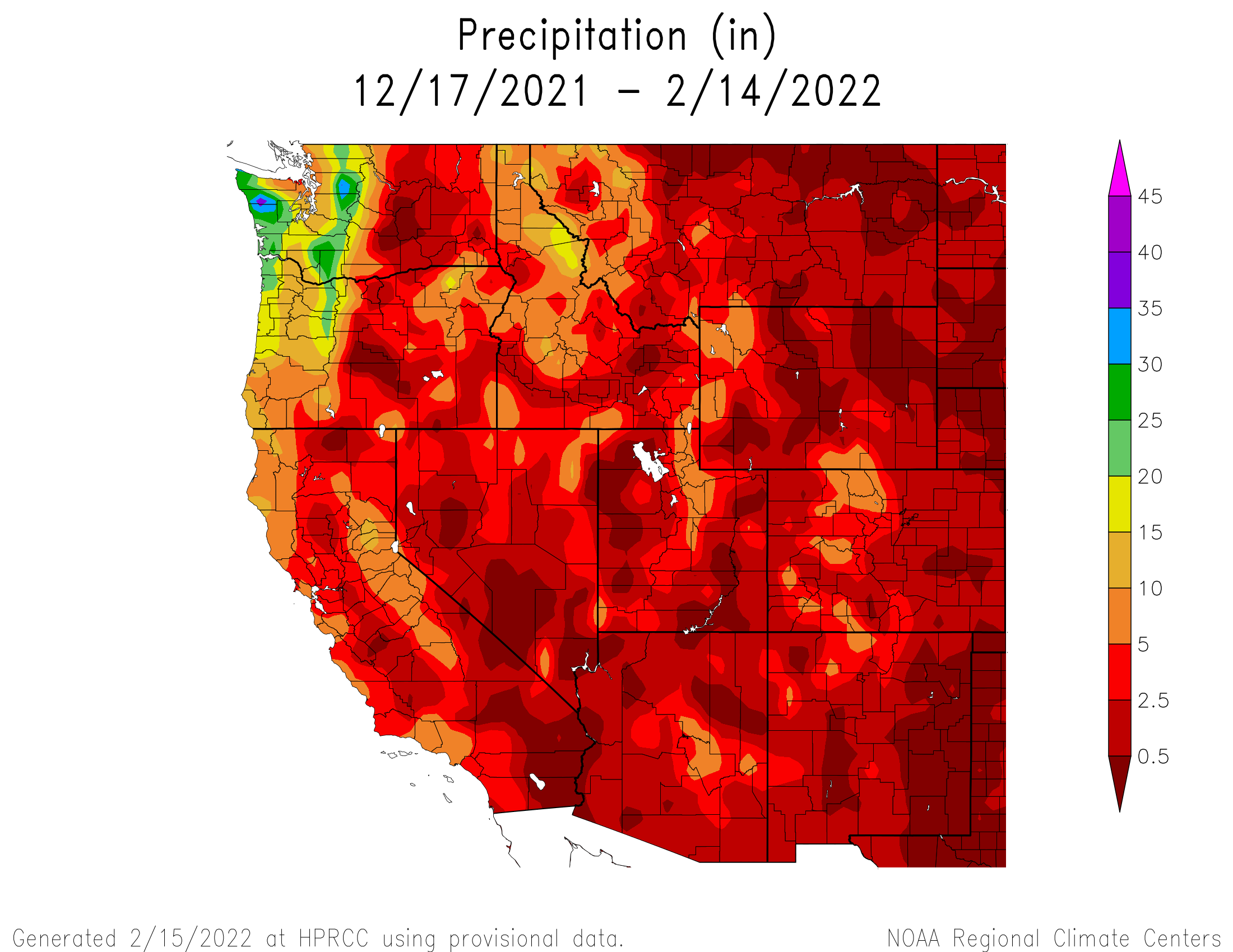
A broad area of surface high pressure resulted in little to no precipitation throughout the contiguous U.S. from February 8 to 14. During this 7-day period, the most significant precipitation (more than 0.5 inch, liquid equivalent) was limited to the Cascades, Upper Mississippi Valley, northern New England, and the Florida Peninsula. Following a wet December with beneficial snowfall, a persistent area of mid-level high pressure anchored near the West Coast led to drier-than-normal conditions across the western U.S. since early January. During the second week of February, above-normal temperatures prevailed throughout the West and much of the Great Plains. Drier weather returned to Puerto Rico by mid-February, while enhanced trade wind showers resumed across the eastern side of Hawaii’s Big Island…
Moderate drought (D1) was degraded to severe drought (D2) across central Kansas and merged with ongoing D2 in southwest Kansas, based on 120-day SPI and soil moisture indicators. Since a 1-category degradation was made the previous week across northern Kansas and eastern Nebraska, these areas remained status quo this week given the time of year when worsening conditions are slower to be realized in terms of impacts. Farther to the north, recent dryness with a lack of snow cover and above normal temperatures resulted in an increase of abnormal dryness (D0) and moderate drought (D1) across northern Nebraska and South Dakota. The updated depiction across the northern to central Great Plains follows closely the 30 to 90-day SPI and soil moisture indicators. Also, the SPI dating back 24 months was also weighed. Drought impacts for South Dakota include many days of high fire danger which is unusual during the winter, low stock ponds, and adverse conditions for recreational snowmobiling. Farther to the north across northern and eastern North Dakota, SPIs at various time scales supported a 1-category improvement. Recent snowfall (6 to 12 inches) and 6-month SPIs prompted a 1-category improvement to the Denver/Boulder metro areas, while 1-category degradations were made to parts of western and southern Colorado based on longer-term SPIs and current snowpack…
Colorado Drought Monitor one week change map ending February 15, 2022.
An expansion of extreme (D3) drought was made to parts of south-central Montana, based on SPI and EDDI at various time scales and soil moisture indicators. Although only light precipitation (less than 0.25 inch liquid equivalent) was observed in northeast Montana, a small area was improved from D3 to D2 due to a reassessment of indicators such as SPI values. Continued improvement of long-term SPI supported a slight reduction of D4 in northwest Montana. Severe (D2) drought was increased slightly in coverage across southwest Utah, as a result of low streamflows (below the 10th percentile) and 30-day SPI. 12-month SPEI along with worsening soil moisture indicators and 28-day average streamflows supported a 1-category degradation across parts of Oregon and adjacent areas of northwest California. The lack of precipitation since early January resulted in 28-day average streamflows falling below the 10th percentile throughout much of western Oregon. Following the persistent dryness since early January and above normal temperatures from early to mid-February, California’s statewide snowpack decreased to 73 percent of normal on Feb 14. If the dry pattern persists through the remainder of February, degradations in the current drought levels may be necessary for the remainder of California…
Southern Plains Drought Monitor map February 15, 2022.
Based on 90-day SPI values and soil moisture indicators, a 1-category degradation was made to parts of Arkansas and adjacent northwest Mississippi. Impacts related to these worsening drought conditions include dry ponds and continued high fire danger. The previous week’s D2 areas in southwest Mississippi and adjacent Louisiana were merged and slightly expanded eastward, consistent with SPoRT soil moisture percentiles, 28-day average streamflows, and 90-day SPI values. Precipitation deficits of more than 8 inches are observed during the past 90 days across a broad area of the Lower Mississippi Valley. Statewide precipitation across Mississippi during November-December-January was the driest since 1985/86. On February 15, a statewide burn ban was issued for Louisiana. An expansion of extreme drought (D3) was made across north-central Oklahoma, based on 90-day SPI and worsening soil moisture indicators. Persistent dryness along with periods of above normal temperatures and enhanced winds this winter prompted an expansion of severe to extreme drought (D2 to D3 ) across the middle Rio Grande Valley. Despite a dry week, a reassessment of SPI values at various time scales and soil moisture indicators supported a 1-category improvement from moderate drought (D1) to abnormal dryness (D0) across the southern Edwards Plateau. According to the USDA’s National Agricultural Statistics Service, 77 percent of the topsoil moisture was rated as poor to very poor across Texas as of February 13. Nearly two-thirds of oats, winter wheat, and rangeland and pastures were rated in poor to very poor condition…
Looking Ahead
On February 17, a low pressure system is forecast to develop with a subsequent track northeastward to the Ohio Valley and Northeast. A swath of snowfall, potentially more than 6 inches, is expected to the northwest of surface low track from the central Great Plains to the Midwest. In the warm sector of this storm system, thunderstorms with locally heavy rainfall (more than 1 inch) are forecast from the Ohio River south to the Lower Mississippi Valley. Mostly dry weather is likely across the Coastal Plain of the Southeast and Florida from Feb 17 to 21. As mid-level low pressure develops over the West on Feb 20 and 21, snow is anticipated to overspread the Cascades, Sierra Nevada Mountains, Great Basin, and Rockies.
The Climate Prediction Center’s 6-10 day outlook (valid Feb 22-26, 2022) depicts a major pattern change over the West and north-central U.S. from earlier in the month. Large probabilities (more than 70 percent) of below normal temperatures are forecast throughout the West and much of the Great Plains. Conversely, large probabilities (more than 70 percent) of above normal temperatures are forecast across the Mid-Atlantic and Southeast. Below-normal precipitation is favored for the Pacific Northwest, Great Basin, California, and Florida. A storm track, consistent with La Nina, elevates probabilities for above normal precipitation across the Ohio and Tennessee Valleys.
US Drought Monitor one week change map ending February 15, 2022.
Nitrogen fertilizers are critical for growing crops to feed the world, yet when applied in excess can pollute our water for decades. A new study provides six steps to address nitrogen pollution and improve water quality.
Since nitrogen persists for so long, management efforts may seem futile and unattractive because it can take a long time to see results. The study from the University of Waterloo appearing in Nature Geoscience provides a roadmap for scientists, policymakers, and the public to overcome the challenges associated with this legacy nitrogen for faster improvements to our water quality.
“We have to think about the legacy we leave for the future in a strategic way from both the scientific and socio-economic angles,” said Nandita Basu, a professor of Earth and Environmental Sciences and Civil and Environmental Engineering at Waterloo and the study’s lead author. “This is a call to action for us to accept that these legacies exist and figure out how to use them to our advantage.”
The study recommends the following six steps:
Focus research to quantify the length of time the nitrogen stays in our ecosystems to adjust our expectations for conservation timelines.
Find ways to use the legacy nitrogen as a resource for growing crops instead of adding new nitrogen fertilizers to our ecosystems with already high levels of nitrogen.
Target conservation strategies to get the maximum water quality improvement instead of a widespread blanket approach.
Combine conservation methods that reduce the amount of nitrogen that has already left the farm fields, such as in wetlands, with methods that harvest nitrogen from past legacies accumulated in the soil.
Monitor water quality at both large and small scales so that short-term results can be seen at scales like a farm field and long-term results downstream at river basins can also be tracked.
When assessing the economic impacts of conservation strategies, incorporate both short- and long-term cost-benefit analyses.
Nitrogen legacies are different around the world depending on the climate and historical land use, and land management patterns. While theoretical knowledge of these legacies has existed for decades, measurements and monitoring have not yet been widespread enough to understand these differences and support water quality policies, where there is still an expectation of short-term water quality improvement.
“It’s time we stop treating nitrogen legacies as the elephant in the room and design watershed management strategies that can address these past legacies,” said Basu. “We need to ask ourselves how we can do better for the future.”
“Increasing incidences of eutrophication and groundwater quality impairment from agricultural nitrogen pollution are threatening humans and ecosystem health. Minimal improvements in water quality have been achieved despite billions of dollars invested in conservation measures worldwide. Such apparent failures can be attributed in part to legacy nitrogen that has accumulated over decades of agricultural intensification and that can lead to time lags in water quality improvement. Here, we identify the key knowledge gaps related to landscape nitrogen legacies and propose approaches to manage and improve water quality, given the presence of these legacies.”
Ranking and time evolution of summer (June–August) drought severity as indicated by negative 0–200 cm soil moisture anomalies. Maps show how gridded summer drought severity in each year from 2000–2021 ranked among all years 1901–2021, where low (brown) means low soil moisture and therefore high drought severity. Yellow boxes bound the southwestern North America (SWNA) study region. Time series shows standardized anomalies (σ) of the SWNA regionally averaged soil moisture record relative to a 1950–1999 baseline. Black time series shows annual values and the red time series shows the 22-year running mean, with values displayed on the final year of each 22-year window. Geographic boundaries in maps were accessed through Matlab 2020a.
Amid a rapid worsening of Western conditions in 2020 and 2021, the dry spell that has gripped the Colorado River Basin for the last 22 years is now the region’s worst drought since at least 800 A.D., researchers concluded in a study published Monday.
The research, conducted by scientists from the University of California Los Angeles and Columbia University and published in the journal Nature Climate Change, also found that human-caused climate change accounts for approximately 42% of the severity of the “megadrought” that the southwestern U.S., including western Colorado, has experienced since 2000.
GET THE MORNING HEADLINES DELIVERED TO YOUR INBOX
“Had the sequence of wet-dry years occurred as observed but without the human-caused drying trend, we estimate that the 2000s would have still been dry, but not on the same level as the worst (of the) last millennium’s megadroughts,” the study’s lead author, UCLA climatologist Park Williams, wrote on Twitter.
The study was conducted using both observed soil-moisture data since 1901 and reconstructed data based on tree-ring records covering the last 1,200 years. No 22-year period during that span was found to have been as dry as the West’s current megadrought.
The study builds on previous research published in 2020, which found that the drought was, at the time, the worst since a prolonged dry spell recorded in the late 16th century. But the severely dry conditions experienced across the Colorado River Basin in the last two years mean that the post-2000 drought has now become the driest period in the available historical record.
“Exceptionally dry soil in 2021 was critical for the current drought to escalate and overtake the 1500s megadrought as the period with the highest 22-year mean severity,” the study’s authors wrote. “Both 2002 and 2021 were probably drier than any other year in nearly three centuries.”
Due to rising atmospheric concentrations of greenhouse gases, parts of Colorado — especially areas on the Western Slope — have warmed by an annual average of 4 degrees Fahrenheit above pre-1900 levels, temperature data from the National Oceanic and Atmospheric Administration show.
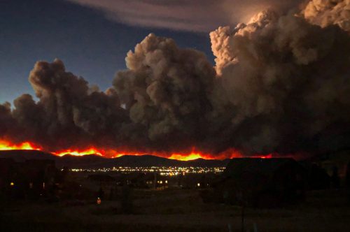
Amid record dry conditions, the three largest wildfires in Colorado history burned in 2020, and all of its 20 largest fires on record have occurred during the current megadrought.
SUPPORT NEWS YOU TRUST.
Colorado Newsline is part of States Newsroom, a network of news bureaus supported by grants and a coalition of donors as a 501c(3) public charity. Colorado Newsline maintains editorial independence. Contact Editor Quentin Young for questions: info@coloradonewsline.com. Follow Colorado Newsline on Facebook and Twitter.
People fishing along the banks of the White River as it winds through Indianapolis sometimes pass by ominous signs warning about eating the fish they catch.
Mercury is a neurotoxic metal that can cause irreparable harm to human health – especially the brain development of young children. It is tied to lower IQ and results in decreased earning potential, as well as higher health costs. Lost productivity from mercury alone was calculated in 2005 to reach almost $9 billion per year.
One way mercury gets into river fish is with the gases that rise up the smokestacks of coal-burning power plants.
The Environmental Protection Agency has had a rule since 2012 limiting mercury emissions from coal-fired power plants. But the Trump administration stopped enforcing it, arguing that the costs to industry outweighed the health benefit.
I study mercury and its sources as a biogeochemist at Indiana University-Purdue University Indianapolis. Before the EPA’s original mercury rule went into effect, my students and I launched a project to track how Indianapolis-area power plants were increasing mercury in the rivers and soil.
Mercury bioaccumulates in the food chain
The risks from eating a fish from a river downwind from a coal-burning power plant depends on both the type of fish caught and the age and condition of the person consuming it.
Mercury is a bioaccumulative toxin, meaning that it increasingly concentrates in the flesh of organisms as it makes its way up the food chain.
The mercury emitted from coal-burning power plants falls onto soils and washes into waterways. There, the moderately benign mercury is transformed by bacteria into a toxic organic form called methylmercury.
Each bacterium might contain only one unit of toxic methylmercury, but a worm chewing through sediment and eating 1,000 of those bacteria now contains 1,000 doses of mercury. The catfish that eats the worm then get more doses, and so on up the food chain to humans.
In this way, top-level predator fishes, such as smallmouth bass, walleye, largemouth bass, lake trout and Northern pike, typically contain the highest amounts of mercury in aquatic ecosystems. On average, one of these fish contains enough to make eating only one serving of them per month dangerous for the developing fetuses of pregnant women and for children.
How coal plant mercury rains down
In our study, we wanted to answer a simple question: Did the local coal-burning power plants, known to be major emitters of toxic mercury, have an impact on the local environment?
The obvious answer seems to be yes, they do. But in fact, quite a bit of research – and coal industry advertising – noted that mercury is a “global pollutant” and could not necessarily be traced to a local source. A recurring argument is that mercury deposited on the landscape came from coal-burning power plants in China, so why regulate local emissions if others were still burning coal?
That justification was based on the unique chemistry of this element. It is the only metal that is liquid at room temperature, and when heated just to a moderate level, will evaporate into mercury vapor. Thus, when coal is burned in a power plant, the mercury that is present in it is released through the smokestacks as a gas and dilutes as it travels. Low levels of mercury also occur naturally.
Although this argument was technically true, we found it obscured the bigger picture.
People sometimes fish along the White River where it flows through Indianapolis. alexeys via Getty Images
We found the overwhelming source of mercury was within sight of the White River fishermen – a large coal-burning power plant on the edge of the city.
When we surveyed hundreds of surface soils ranging from about 1 to 31 miles (2 to 50 km) from the coal-fired power plant, then the single largest emitter of mercury in central Indiana, we were shocked. We found a clear “plume” of elevated mercury in Indianapolis, with much higher values near the power plant tailing off to almost background values 31 miles downwind.
The White River flows from the northeast to the southwest through Indianapolis, opposite the wind patterns. When we sampled sediments from most of its course through central Indiana, we found that mercury levels started low well upstream of Indianapolis, but increased substantially as the river flowed through downtown, apparently accumulating deposited mercury along its flow path.
We also found high levels well downstream of the city. Thus a fisherman out in the countryside, far away from the city, was still at significant risk of catching, and eating, high-mercury fish.
The region’s fish advisories still recommend sharply limiting the amount of fish eaten from the White River. In Indianapolis, for example, pregnant women are advised to avoid eating some fish from the river altogether.
Reviving the MATS rule
The EPA announced the Mercury and Air Toxic Standards rule in 2011 to deal with the exact health risk Indianapolis was facing.
The rule stipulated that mercury sources had to be sharply reduced. For coal-fired power plants, this meant either installing costly mercury-capturing filters in the smokestacks or converting to another energy source. Many converted to natural gas, which reduces the mercury risk but still contributes to health problems and global warming.
The MATS rule helped tilt the national energy playing field away from coal, until the Trump Administration attempted to weaken the rule in 2020 to try to bolster the declining U.S. coal industry. The administration rescinded a “supplemental finding” that determined it is “appropriate and necessary” to regulate mercury from power plants.
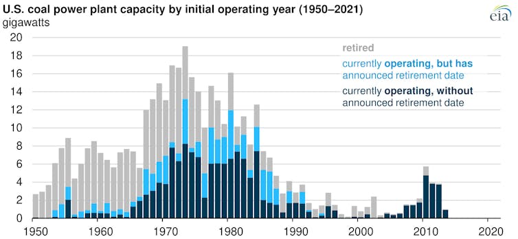
More than a quarter of U.S. coal-fired power plants currently operating were scheduled as of 2021 to be retired by 2035. EIA
Some economists have calculated the net cost of the MATS rule to the U.S. electricity sector to be about $9.6 billion per year. This is roughly equal to the earlier estimates of productivity loss from the harm mercury emissions cause.
To a public health expert, this math problem is a no-brainer, and I am pleased to see the rule back in place, protecting the health of generations of future Americans.
Gabriel Filippelli, Chancellor’s Professor of Earth Sciences and Executive Director, Indiana University Environmental Resilience Institute, IUPUI
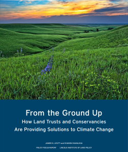
As the need to address the climate crisis grows ever more urgent, land conservationists are taking meaningful action to reduce carbon in the atmosphere and protect natural systems from the unavoidable impacts of a warming planet.
Our new Policy Focus Report documents how land trusts and conservancies are developing and implementing creative, nature-based strategies to address climate change around the globe, from the Great Plains of the United States to the high-altitude wetlands of Ecuador.
In this report, we document a dozen case examples that demonstrate how conservation organizations can help to mitigate and adapt to a changing climate.
Paul Bruchez speaking from his ranch in Grand County to the Colorado River Water Users Association Annual Convention December 16, 2021. Governor Polis has nominated Bruchez to the Colorado Water Conservation Board as the mainstem Colorado River representative.
Click on the link to read the article at Aspen Journalism (Heather Sackett):
Gov. Jared Polis has appointed a Kremmling rancher to replace former state Sen. Gail Schwartz on the state’s top water board.
Paul Bruchez will now represent the main stem of the Colorado River on the Colorado Water Conservation Board. Bruchez, 40, currently serves as the agriculture representative and vice chair of the Colorado Basin Roundtable.
Rancher and fly fishing guide Paul Bruchez’s daughter and nephew sit in a hay field at the family ranch near Kremmling. Bruchez is helping spearhead a study among local ranchers, which could inform a potential statewide demand management program. Photo credit: Paul Bruchez via Aspen Journalism
Along with his family, Bruchez runs Reeder Creek Ranch, a 6,000-acre cattle and hay operation, about five miles east of Kremmling, which is irrigated with water from the headwaters of the Colorado River. Bruchez is also a fly-fishing guide and has been active since about 2012 in state-level water management discussions. He is a governor appointee to the Inter-Basin Compact Committee and is on the board of the Colorado Water Trust.
“For the last 23 years, everything Colorado River and water has touched and impacted my life substantially, as well as my entire family,” he said. “We all live and breathe Colorado River issues.”
This mowed hay field is part of Reeder Creek Ranch, owned by the Bruchez family near Kremmling. Little data exists on the impacts of reducing irrigation water on higher elevation pastures like this one, but Paul Bruchez and a group of local ranchers have volunteered their fields for a study that will help scientists learn more about what happens to pastures that receive less irrigation water. Photo credit: Paul Bruchez via Aspen Journalism
Bruchez is also spearheading a project with other neighboring irrigators to see what happens when water is temporarily removed from high-elevation hay meadows. The results of the state grant-funded study could have implications for demand management, a program state officials are exploring, designed to save water by paying irrigators to temporarily fallow fields.
Tri-State Generation and Transmission has a power-purchase agreement for 104 megawatts of generating capacity from the Crossing Trails Wind Farm, a wind farm between Seibert and Kit Carson, in eastern Colorado, on October 3, 2021. Photo: Allen Best/Big Pivots
Click on the link to read the article on Big Pivots (Allen Best):
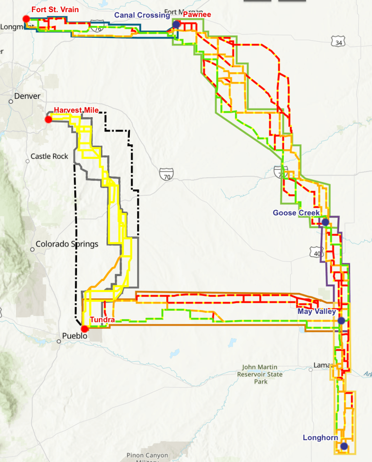
Transmission that will be critical to delivering wind energy from farms and ranches in eastern Colorado to electrical consumers along the Front Range was tentatively approved by the Public Utilities Commission on Feb. 11.
Click the image to go to Xcel’s project page and the interactive map.
The PUC commissioners will again take up the proposal by Xcel Energy on Feb. 23 to work through more details of what will likely produce $1.7 billion of transmission in a gigantic, 560-mile loop around eastern Colorado called the Pathway Project. Slightly less certain is approval of a 90-mile extension to wind-rich Baca County in the state’s southeastern corner. The cost tag of that extension is $250 million.
Some testimony had been filed with the PUC arguing that the massive investment as prposed was unneeded for Xcel to achieve its mandated carbon-reduction goals of 80% by 2030 as compared to 2005. PUC commissioners were not persuaded. They quickly concluded that Xcel had indeed delivered the evidence that the proposed 345-kV double-circuit transmission line will be needed—and soon.
“Time is of the essence. We don’t know what impediments might creep up as the project proceeds,” said John Gavan, one of the three commissioners.
“I also think it’s important to realize that this project will support generation beyond our planning with the current electric resource plan,” he added, referring to Xcel’s separate but concurrent proposal for new wind and solar projects, as well as natural gas plants and storage.
The PUC’s two other commissioners shared similar thoughts about urgency.
“They’ve met their burden (of proof) here,” said Megan Gilman. “I don’t want perfect to be the enemy of the good,” said Eric Blank, the commission chairman.
Xcel’s plans for transmission coupled with a concurrent proposal for new wind, solar, and other resources could deliver investments approaching $9 billion in coming years. This will allow Colorado’s largest electrical utility to close coal plants and likely will slow rate increases or possibly halt them altogether. Some utilities have actually been able to lower rates as they have pivoted to renewables.
“A really big moment in my career,” says Mark Detsky, an attorney who represents the Colorado Independent Energy Association, an organization of wind and other energy developers.
Many states have struggled to build the transmission necessary to more fully develop renewable resources. Texas and California have been exceptions, and Colorado will join them, says Detsky.
“There have been many, many studies that have shown that this is what the United States needs to do to meaningfully decarbonize,” he says.
“It has to have massive transmission infrastructure that maximizes the wind and solar resources across a wide geographic range.”
If Xcel’s plans get approved as proposed, the company’s renewable generation portfolio will double by 2030 as compared to the growth in renewables in the previous 17 years.
Transmission tower near Firestone. Photo credit: Allen Best/The Mountain Town News
To pull the trigger on that generation, though, the company needs transmission. In the past, both in Colorado and elsewhere, the two have gone forward on almost entirely separate paths. In this case, they’re separate but concurrent.
“It is one of the first times in Colorado, if not nationally, that this chicken-and-egg transmission problem has hopefully been addressed,” said Ellen Howard Kutzer, a senior staff attorney with Western Resource Advocates, an advocacy organization that participates in most utility cases before the PUC.
“We are being thoughtful about the needs of the next 5 to 10 years but also building transmission for future needs as well,” she said. “That’s something that I heard in the deliberations.”
The proposal for Colorado’s Pathway Project was submitted to the PUC in March 2021. Xcel was bolstered by a non-unanimous but comprehensive settlement agreement filed in November by a variety of environmental, labor, and state agencies, including the staff of the PUC. That agreement indicated broad support for Xcel’s plans.
Tri-State Generation and Transmission, Colorado’s second largest utility, which is also proposing a sharp pivot in its generation, filed testimony with the PUC that showed that in every case its own plans for more renewable generation will benefit from the new transmission in eastern Colorado.
Consumer groups had different advice: Go slower. The Colorado Office of the Utility Consumer Advocate and others argued that only one of the five segments proposed by Xcel, the 160-mile leg from near Brush-Fort Morgan to the Burlington area, could be justified at this time, as it would deliver nearly the same benefits but at a fraction of the costs.
The PUC commissioners agreed only to the extent that they want to see that segment and another shorter segment to a substation north of Lamar, a total of 225 miles, get done first. This will allow the wind projects to get federal tax credits that are scheduled to end, although such tax credits have been extended many times in the past. The three other segments closer to the Front Range have slightly less pressing need.
Uncertainty about the future of federal tax credits, both production and investment, also has the PUC commissioners fretting about what to do about the 90-mile extension to Baca County.
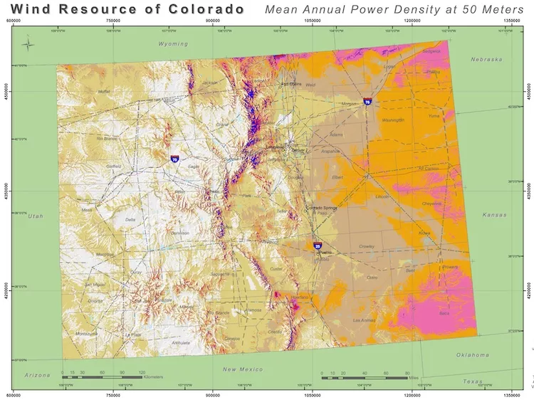
Studies by the National Renewable Energy Laboratory and others have shown southeastern Colorado to have the steadiest, strongest winds in all of Colorado. That should perhaps not be a surprise, as it was at the heart of the Dust Bowl during the 1930s. Xcel has proposed the $250 million extension from its Colorado’s Pathway Project loop. And consumer groups, if skeptical about other segments, are willing to see conditional approval.
The most resistant voice to approving the extension is perhaps the individual in the proceedings who knows most about the plentitude of wind in the Springfield area. As a wind developer in 2007, said Blank, he had investigated development opportunities in Baca County. He knows the potential, he said.
As an attorney, though, he worries about procedure if the PUC approves the May Valley-Longhorn extension into Baca County. Xcel, he said, had failed to document the benefits. “They didn’t even try,” he said. “There’s nothing in this record to quantify the benefit.”
Gavan pushed back. He said the extension from May Valley will be a “building block for the future.” He said he will support a conditional approval—and it needs to be understood as an approval that can save Xcel customers money in the long run. An earlier, rather than later, conditional approval helps open the door for development aided by the federal tax credits.
The federal tax credits are set to expire late this year. If Congress does not renew them, then the projects that are bid later will come in at a higher cost.
The three commissioners will be working this over hard with the aid of PUC staff members before their Feb. 23 meeting.
They’ll also be working over what are called performance-incentive mechanisms, or PIMs. Most people would call this the bag of carrots and sticks. The goal is to get the transmission built without unnecessary cost.
Transmission at a recent conference was described as difficult but doable. “Transmission is hard to build on one hand, and on the other hand it’s really not,’ said Mark Gabriel, the chief executive of Untied Power, Colorado’s second largest electrical cooperative. It costs a “ton of money,” he explained, and “permitting is a pain in the butt.” That said, it can get done.
In this case, the scale matters. PUC staff member Dan Greenberg told the commissioners that Xcel will have to work with 700 landowners as it puts together the transmission segments that go on-line, the first segments in 2025 and the remaining three segments by the end of 2027. There will be environmental issues, such as habitat of the lesser prairie chicken, uncertainty over price of materials—and more.
All three commissioners have backgrounds in business, with Blank and Gilman both having careers in renewable generation and Gavan in information technology prior to their appointments. They sometimes drew on personal experience in balancing bonuses and penalties so that Xcel gets the transmission built in time for Colorado to meet its decarbonization goals and without wasting money along the way. There is much talk about avoiding “cliffs.” Speed bumps and flying lights weren’t discussed, but you get the idea.
Another decision, but this one without footnotes, is about undergrounding. Lots of people would like to see transmission lines go underground, but Xcel had testified that the cost would increase 20-fold. That persuaded the PUC commissioners.
Undergrounding, however, might conceivably be involved some day in exporting electricity generated by solar panels in the San Luis Valley, Colorado’s richest area for solar. The commissioners are receptive to opening a miscellaneous proceeding late this year. That means nothing will necessarily happen, although it does represent a victory for the Colorado Solar and Storage Association.
A turbine whirls on a farm east of Burlington, Colo. Colorado’s eastern plains already have many wind farms—but it may look like a pin cushion during the next several years. Photo/Allen Best
The final major issue decided at least tentatively by the PUC commissioners was how much stock to put into the testimony of Larry Miloshevich, a Lafayette resident who has been conducting a deep investigation of evolving technology for electrical transmission. In the acronym-rich discussion, it was called ATT, or advanced transmission technologies.
Gavan gushed about the promise of such technologies, particularly one called carbon-core conduits that he said could eliminate upwards of 500 transmission towers. He pointed out that North Dakota-based Basin Electric used the technology on a 27-mile, 230-kV transmission line. If Basin, a distinctly conservative generation and transmission association, could embrace the technology, he argued, then certainly it should behoove Xcel Energy with its reputation for being one of the nation’s most progressive utilities, to do the same.
Blank, the chairman and an attorney, was resistant. He wanted stronger evidence for the record before he was willing to make it a conditional requirement of approval.
This most certainly will be discussed again. “I strongly support that it could really transform this world, but we just want to be careful about creating a (legal) mess,” said Blank.
Afterward, Miloshevich said he was pleased with the interest shown in his studies about advanced transmission technology, especially the use of advanced carbon-core conductors as a superior alternative to traditional aluminum-conducted steel-reinforced conductors.
“Carbon-core conductor (technology) in general has a 20-year history and a solid performance record” aside from fragility issues during installation, which have now been addressed, he wrote in an email.
Miloshevich said he believes a more careful combing of his testimony will demonstrate to the satisfaction of PUC commissioners that there is sufficient evidence to justify making it a requirement.
Some of the snowmelt flowing in the Blue River as it joins the Colorado River near Kremmling, Colo., will reach the Lower Basin states. Dec. 3, 2019. Credit: Mitch Tobin, the Water Desk
Click the link to read the deep-dive on Greebiz (Vanessa Vaughn). Here’s an excerpt:
From small businesses to Fortune 500 companies, it’s clear that companies of all shapes and sizes want to operate, expand and invest in the Centennial State. The high quality of life is no secret, and it remains a top reason why Colorado has had one of the fastest growing populations over the past decade. However, with growth comes added stress on its infrastructure. And one area where this is most apparent is the state’s blue infrastructure: water.
Businesses are starting to take note of the state’s water resources and the challenges facing western states. Climate change, drought, wildfires and population growth are stressing its water systems as never before. Record-low water levels made national headlines this year, leading to the first federally declared water shortage in the Colorado River Basin. In addition, outdated water policies have led to inefficient use of our resources and politically charged debates over who has control of water, often pitting Western Slope against Front Range.
Just how valuable is the Colorado River to the state? A 2014 study from Arizona State University measured the river’s economic impact and found that if Colorado River water was no longer available to residents, businesses, industry and agriculture for just one year, nearly 60 percent of Colorado’s gross state product — $189 billion — would be lost. More than 2 million jobs would also be gone, with the hardest-hit private sectors being healthcare and social services; professional, scientific and technical services; finance and insurance; retail trade; and real estate and rental…
Business for Water Stewardship helps companies large and small move beyond just reducing their water footprint by advancing collective action that accelerates real, measurable and lasting solutions for water, nature and business. “Right now, companies have the opportunity to be transformational leaders in water stewardship,” said Reeve. “The private sector can leverage its innovation and critical thinking to develop strategies for large-scale, system-wide changes that will address our complex water challenges.”
[…]
The state has welcomed participation from the business community in developing the Colorado Water Plan, a blueprint with measurable objectives for water sustainability across the state. In fact, the Water Plan doesn’t work without them. Russ Sands, section chief of water supply planning for the Colorado Water Conservation Board (CWCB), the state’s overseer of the plan, said the Water Plan is unique because of its inclusivity of stakeholders. “Everyone has a seat at the table, everyone is part of the conversation, and it is that collaboration that will make the Water Plan successful,” said Sands…
As a headwaters state, Colorado is the center of the West’s water crisis. It has the opportunity to be a model for the downstream states and the rest of the country, by demonstrating, through its actions and policies, how it is not only planning for the water it has right now but also preparing for an uncertain future, as climate change and a growing population continue to strain its water resources.
The business community is proving to be an emerging champion for advancing water conservation and restoration, and leveraging the resources of the private sector is helping to catalyze large-scale water solutions that benefit nature, businesses and communities.
Click the link to read the article on American Rivers (Fay Hartman):
Across the southwest, water is an essential, often scarce resource that communities rely on for their ways of life. In south-central Colorado, the Rio Grande, its tributaries and the water flowing underground supports communities across the San Luis Valley, an 8,000 square-mile high elevation desert that sees less than seven inches of precipitation per year. Water ties generations of people and communities together across the Valley. Married by shared ethics of caring for land and water, everyone across the San Luis Valley depends deeply on the Rio Grande – for their livelihoods, the rich diversity of wildlife and outdoor activities, and a deep connection to the rich history of people who have come before them.
Rio Grande River, CO | Photo By Sinjin Eberle
To help tell the story of the San Luis Valley, the interdependent nature of the people, the river and water flowing below their feet and the threats facing the Valley’s way of life, American Rivers developed Groundswell on the Rio Grande, an interactive ESRI Story Map that illustrates the connection between people, communities and water.
In developing the Story Map, we had the pleasure of engaging with a wide cross-section of people that rely on and appreciate the Valley’s waters for different reasons. Whether we talked to a rancher, small business owner, recreation advocate, retired bus driver, brewer or water manager, it was clear how important the Valley, and the Valley’s water is to them. Water undeniably touches everyone in the Valley, but it is the threats to the rivers and aquifers that bring communities together to fight for their water.
San Luis People’s Ditch March 17, 2018. Photo credit: Greg Hobbs
The global temperature for January 2022 was the sixth highest for January in the 143-year NOAA record, which dates back to 1880. According to NCEI’s Global Annual Temperature Rankings Outlook, it is virtually certain (> 99.0%) that the year 2022 will rank among the 10 warmest years on record.
This monthly summary, developed by scientists at NOAA’s National Centers for Environmental Information, is part of the suite of climate services NOAA provides to government, business, academia and the public to support informed decision-making.
Monthly Global Temperature
The January 2022 global surface temperature was 1.60°F (0.89°C) above the 20th-century average of 53.6°F (12.0°C) and ranked as the sixth-warmest January in the 143-year record. January 2022 also marked the 46th consecutive January and the 445th consecutive month with temperatures, at least nominally, above the 20th-century average.
Temperatures were much above average across most of South America, resulting in its second-warmest January on record. Only January of 2016 was warmer. Much of the Atlantic, northern Indian, and western Pacific oceans, as well as parts of southern North America, western and southern Africa, and southern Asia had much-above-average temperatures. Meanwhile, cooler-than-average temperatures were observed across parts of northern North America, northern Africa, India, and the Pacific Ocean.
Asia, as a whole, had its fourth-warmest January on record, while Oceania’s January temperature departure tied with 2001 as the seventh highest on record. Despite North America and Africa’s above-average January temperature, they had their coldest January since 2009 and 2015, respectively.
Sea Ice and Snow Cover
According to data from NOAA and analysis by the Rutgers Global Snow Lab, the Northern Hemisphere snow cover extent during January was slightly above the 1981-2010 average at 18.26 million square miles. This was the largest January snow cover extent since 2017. North America had near-average January snow cover extent, while Eurasia had slightly above-average January snow cover extent.
The January 2022 Arctic sea ice extent averaged 5.36 million square miles, which is 208,000 square miles below the 1981-2010 average. Although the monthly sea ice extent was below average for the month, it was the largest January extent since 2009. According to the National Snow and Ice Data Center (NSIDC), regional sea ice extent was below average in the Sea of Okhotsk, Barents Sea, and the Gulf of St. Lawrence, while the Bering Sea had above-average extent for the month.
The Antarctic sea ice extent for January 2022 was the second smallest January sea ice extent in the 44-year record at 1.49 million square miles, which is 440,000 square miles below average. Only January of 2017 had a smaller sea ice extent at 470,000 square miles below average.
Global Tropical Cyclones
Six tropical storms formed globally in January, which is near normal. However, most of them were weak, so the accumulated cyclone energy (ACE: an integrated metric of the strength, frequency, and duration of tropical storms) was the third lowest since 1981. The Northern Hemisphere had no tropical cyclone activity during January 2022, which is not unusual. In the Southern Hemisphere, the strongest cyclone that formed during the month was Major Cyclone Batsirai, which made landfall in Madagascar in early February as an equivalent Category 3 cyclone on the Saffir-Simpson scale.
Ranking and time evolution of summer (June–August) drought severity as indicated by negative 0–200 cm soil moisture anomalies. Maps show how gridded summer drought severity in each year from 2000–2021 ranked among all years 1901–2021, where low (brown) means low soil moisture and therefore high drought severity. Yellow boxes bound the southwestern North America (SWNA) study region. Time series shows standardized anomalies (σ) of the SWNA regionally averaged soil moisture record relative to a 1950–1999 baseline. Black time series shows annual values and the red time series shows the 22-year running mean, with values displayed on the final year of each 22-year window. Geographic boundaries in maps were accessed through Matlab 2020a.
Click the link to access the paper at Nature Climate Change (A. Park Williams, Benjamin I. Cook & Jason E. Smerdon). Here’s the abstract:
A previous reconstruction back to 800 CE indicated that the 2000–2018 soil moisture deficit in southwestern North America was exceeded during one megadrought in the late-1500s. Here, we show that after exceptional drought severity in 2021, ~19% of which is attributable to anthropogenic climate trends, 2000–2021 was the driest 22-yr period since at least 800. This drought will very likely persist through 2022, matching the duration of the late-1500s megadrought.
Salvage crew at St. Thomas, Nevada during Lake Mead first fill, 1938 via University of Nevada Las Vegas
Click the link to view an article on The Los Angeles Times (Ian James). Here’s an excerpt:
In their research, the scientists examined major droughts in southwestern North America back to the year 800 and determined that the region’s desiccation so far this century has surpassed the severity of a megadrought in the late 1500s, making it the driest 22-year stretch on record. The authors of the study also concluded that dry conditions will likely continue through this year and, judging from the past, may persist for years.
The researchers found the current drought wouldn’t be nearly as severe without global warming. They estimated that 42% of the drought’s severity is attributable to higher temperatures caused by greenhouse gases accumulating in the atmosphere…
Williams and his colleagues compared the current drought to seven other megadroughts between the 800s and 1500s that lasted between 23 years and 30 years.
Concentric rings of various widths mark the annual growth of trees. Photo by Peter Brown, Rocky Mountain Tree-Ring Research. Photo credit: NOAA
They used ancient records of these droughts captured in the growth rings of trees.
Wood cores extracted from thousands of trees enabled the scientists to reconstruct the soil moisture centuries ago. They used data from trees at about 1,600 sites across the region, from Montana to California to northern Mexico…
Some scientists describe the trend in the West as “aridification” and say the region must prepare for the drying to continue as temperatures continue to climb.
Brad Udall: Here’s the latest version of my 4-Panel plot thru Water Year (Oct-Sep) of 2021 of the Colorado River big reservoirs, natural flows, precipitation, and temperature. Data (PRISM) goes back or 1906 (or 1935 for reservoirs.) This updates previous work with @GreatLakesPeck.
Click the link to read an article from The New York Times (Henry Fountain). Here’s an excerpt:
But exceptional conditions in the summer of 2021, when about two-thirds of the West was in extreme drought, “really pushed it over the top,” said A. Park Williams, a climate scientist at the University of California, Los Angeles, who led an analysis using tree ring data to gauge drought. As a result, 2000-21 is the driest 22-year period since 800 A.D., which is as far back as the data goes…
Julie Cole, a climate scientist at the University of Michigan who was not involved in the research, said that while the findings were not surprising, “the study just makes clear how unusual the current conditions are.”
Dr. Cole said the study also confirms the role of temperature, more than precipitation, in driving exceptional droughts. Precipitation amounts can go up and down over time and can vary regionally, she said. But as human activities continue to pump greenhouse gases into the atmosphere, temperatures are more generally rising.
As they do “the air is basically more capable of pulling the water out of the soil, out of vegetation, out of crops, out of forests,” Dr. Cole said. “And it makes for drought conditions to be much more extreme.”
[…]
Although there is no uniform definition, a megadrought is generally considered to be one that is both severe and long, on the order of several decades. But even in a megadrought there can be periods when wet conditions prevail. It’s just that there are not enough consecutive wet years to end the drought.
That has been the case in the current Western drought, during which there have been several wet years, most notably 2005…
Several previous megadroughts in the 1,200-year record lasted as long as 30 years, according to the researchers. Their analysis concluded that it is likely that the current drought will last that long. If it does, Dr. Williams said, it is almost certain that it will be drier than any previous 30-year period…
Monsoon rains in the desert Southwest last summer had offered hope that the drought might come to an end, as did heavy rain and snow in California from the fall into December.
But January produced record-dry conditions across much of the West, Dr. Williams said, and so far February has been dry as well. Reservoirs that a few months ago were at above-normal levels for the time of year are now below normal again, and mountain snowpack is also suffering. Seasonal forecasts also suggest the dryness will continue.
Lake Powell boat ramp at Page, Arizona, December 17, 2021. Photo credit: Allen Best/Big Pivots
Click the link to read an article on National Public Radio (Nathan Rott). Here’s an excerpt:
Today, the region is home to tens of millions of people, massive agricultural centers and some of the fastest-growing cities in the U.S. — all in an area where there’s less water available than there was in the past, partially due to human-caused climate change.
“We have a society that’s relying on there being the amount of water there was in the 1900s,” said the study’s lead author, Park Williams, a bioclimatologist at the University of California, Los Angeles. “But now with the number of water molecules available to us declining, it really is time for us to get real about how much water there is for us to use.”
[…]
Lake Mead and Lake Powell, the country’s two largest reservoirs, are filled at only about one-third of their total capacity. Communities, ranchers and farmers have depleted groundwater stores to meet demands…
Existing management guidelines for the Colorado River are set to expire in 2026. The seven states that draw from the watershed are negotiating with the federal government, Native American tribes and Mexico over what future management should look like.
Last December, Nevada, Arizona and California agreed to take less water from the Colorado River in an effort to prop up Lake Mead, and more cuts could follow…
“We actually have to change our relationship with water,” [Park Williams said.]
This photo from December 2021 shows one of the intake towers at Hoover Dam. California, Nevada and Arizona recently penned a deal to keep 500,000 acre-feet of water in Lake Mead to boost the declining reservoir levels. CREDIT: HEATHER SACKETT/ASPEN JOURNALISM
Click the link to read an article on The Pueblo Chieftain (Seth Borenstein). Here’s an excerpt:
A dramatic drying in 2021 – about as dry as 2002 and one of the driest years ever recorded for the region – pushed the 22-year drought passed the previous record-holder for megadroughts in the late 1500s and shows no signs of easing in the near future, according to a study Monday in the journal Nature Climate Change…
Williams studied soil moisture levels in the West – a box that includes California, Wyoming, Utah, Nevada, Arizona, most of Oregon and Idaho, much of New Mexico, western Colorado, northern Mexico, and the southwest corners Montana and Texas – using modern measurements and tree rings for estimates that go back to the year 800. That’s about as far back as estimates can reliably go with tree rings…
West Drought Monitor map February 8, 2022.
The drought monitor says 55% of the U.S. West is in drought with 13% experiencing the two highest drought levels…
Climate change from the burning of fossil fuels is bringing hotter temperatures and increasing evaporation in the air, scientists say.
Williams used 29 models to create a hypothetical world with no humancaused warming then compared it to what happened in real life – the scientifically accepted way to check if an extreme weather event is due to climate change. He found that 42% of the drought conditions are directly from human-caused warming. Without climate change, he said, the megadrought would have ended early on because 2005 and 2006 would have been wet enough to break it.
The study “is an important wakeup call,” said Jonathan Overpeck, dean of environment at the University of Michigan, who wasn’t part of the study. “Climate change is literally baking the water supply and forests of the Southwest, and it could get a whole lot worse if we don’t halt climate change soon.”
Williams said there is a direct link between drought and heat and the increased wildfires that have been devastating the West for years. Fires need dry fuel that drought and heat promote.
USFS highest risk firesheds January 2022.
Click the link to read an an article from The Washington Post (Diana Leonard). Here’s an excerpt:
The extreme heat and dry conditions of the past few years pushed what was already an epic, decades-long drought in the American West into a historic disaster that bears the unmistakable fingerprints of climate change. The long-running drought, which has persisted since 2000, can now be considered the driest 22-year period of the past 1,200 years, according to a study published Monday in the journal Nature Climate Change…
The double whammy of searing heat and persistent drought in recent years reflects the steady increase in global temperatures brought on by the burning of fossil fuels. The authors attribute 19 percent of the severe 2021 drought, and 42 percent of the extended drought since the 21st century began, to human-caused climate change…
This “background drying” brought on by a warmer atmosphere can dwarf occasional wet or cool periods. For example, the Southwest’s 2021 drought maintained its grip despite robust monsoon rains and record summer precipitation in some areas, in part because of extraordinary heat waves early last summer, and generally above-average temperatures…
The study finds that the 21st century has been substantially drier than the previous five decades, with 8.3 percent less precipitation, and nearly 1 degree Celsius (1.8 Fahrenheit) warmer than the period from 1950 to 1999…
That analysis found that at the current warming trajectory, droughts in drying regions that previously occurred only once every 10 years are now happening about 1.7 times per decade, on average. If the Earth warms 2 degrees Celsius, scientists expect those once-rare events to take place roughly 2½ times per decade, on average…
From Wednesday through Sunday, the National Weather Service in Los Angeles issued the first heat advisory on record during the winter months in Southern California. Scores of record high temperatures were set, from San Diego to San Francisco.
Death Valley soared to 94 degrees on Feb. 11, its highest temperature recorded so early in the season.
Douglas Fir tree rings via the Western Water Assessment
Click the link to read an article on The Guardian (Gabrielle Canon):
Turning up the temperature – the result of human caused warming – has played a big part. Other studies show how the climate crisis “will increasingly enhance the odds of long, widespread and severe megadroughts”, the researchers write. Noting that as the west is now in the midst of the driest 22-year period in knowable history, “this worst-case scenario already appears to be coming to pass”.
The research builds on conclusions from a previous study, also led by Williams, that ranked the period between 2000 and 2018 as the second driest in 12 centuries. The last two incredibly dry years – which were marked by record-setting heatwaves, receding reservoirs, and a rise in dangerously erratic blazes that burned both uncontrollably and unseasonably – were enough to push this period into first…
Looking at moisture levels in soils, the team of climate scientists from UCLA, Nasa, and Columbia University focused on landscapes from Montana to northern Mexico north to south and from the Pacific Ocean to the Rocky Mountains. They analyzed data collected tree ring patterns that offered clues to soil moisture levels throughout the centuries. Rings that appear closer together show the stunted growth patterns occurring during dry times…
According to Jason Smerdon, a climate scientist at the Lamont-Doherty Earth Observatory of Columbia University who worked with Williams on the study, the crisis is a “slow-motion trainwreck”.
“These multi-decade periods of dryness will only increase with the rest of the century,” Smerdon said.
Still, Smerdon cast the conclusions in a more hopeful light. The extreme events taking place right in people’s backyards may spur understanding and action. “Knowing is half the battle,” he says. “We have a lot of challenges in front of us but we all have agency in the face of this. And there are pathways we can take that are much more sustainable and involve much less risk than the burn baby burn approach that we would take if we didn’t do anything.”
The bill creates the groundwater compact compliance and sustainability fund to help finance groundwater use reduction efforts in the Rio Grande River Basin and the Republican River Basin, including buying and retiring irrigation wells and irrigated acreage.
The Colorado Water Conservation Board administers the fund and can make expenditures based on recommendations from the board of directors of the Rio Grande Water Conservation District or the Republican River Water Conservation District. A conservation district’s recommendations must first be approved by the state engineer…
Clearly referencing the water development investment group Renewable Water Resources (RWR), Donovan wanted to know how to explain a group of people wanting to export water from the valley when it is clear water scarcity is already an issue. Robbins, who was testifying at the time, responded that it was something they “were trying to understand themselves” but said that the Rio Grande Water Conservation District is united in their resolve to fight the efforts with all they have.
Referencing the RWR proposal, Donovan then commented that being given money to build a senior citizen center or for law enforcement won’t help much if there are no senior citizens or communities left. She then commented that the General Assembly is receiving the message that the group “needs to look for water somewhere else.”
South Platte River Storage Study Area. Illustration shows water availability, in blue circles, compared with demand at various places along the South Platte River. The yellow area is the study area. (Illustration by Stantec).
Joe Frank, manager of the Lower South Platte Water Conservancy District based in Sterling, shared the bill with his board of directors during their regular meeting [February 8, 2022]. The board later voted to support the bill.
The bill specifically lists two intended purposes of the prioritization – to “(increase) the beneficial consumptive use of Colorado’s undeveloped waters to which Colorado is entitled under the South Platte River Compact,” and to “reduce reliance on transmountain diversions.”
According to the bill, the CWBC would create a construction fund into which any money appropriated by the General Assembly for water projects would be held. Interest on the investments from the fund would revert back into the fund, and unexpended funds would not be returned to the legislature at the end of the year.
In addition, when allocating money for water storage projects, CWBC would give projects in the South Platte Basin top priority.
Nebraska Rivers Shown on the Map: Beaver Creek, Big Blue River, Calamus River, Dismal River, Elkhorn River, Frenchman Creek, Little Blue River, Lodgepole Creek, Logan Creek, Loup River, Medicine Creek, Middle Loup River, Missouri River, Niobrara River, North Fork Big Nemaha River, North Loup River, North Platte River, Platte River, Republican River, Shell Creek, South Loup River, South Platte River, White River and Wood River. Nebraska Lakes Shown on the Map: Harlan County Lake, Hugh Butler Lake, Lake McConaughy, Lewis and Clark Lake and Merritt Reservoir. Map credit: Geology.com
Leaders from Nebraska’s irrigation and natural resources districts cast the plan as a crucial step to preserve as much of the state’s water supply as possible. Republican Gov. Pete Ricketts identified it as a top priority, arguing that not moving forward would eventually cost Nebraska billions as farms, cities and other water users struggle with shortages…
Tom Riley, director of the Nebraska Department of Natural Resources, said cutbacks on the river would force water regulators to release more water from Lake McConaughy, a major reservoir of the North Platte River, which converges with the South Platte River to form the Platte River.
Riley said the reduced flows would also affect power generation in the state, force farmers to retire productive farmland and hurt municipal water supplies within the river basin. Nebraska also relies on the river at some of its public power stations, including a coal-powered facility that uses water for cooling…
Elizabeth Elliott, director of Lincoln’s Transportation and Utilities agency, said Lincoln relies on the Platte River to supplement the water it draws from wells. She said water from the South Platte River provides about 7% of the city’s water…
The South Platte River Basin is shaded in yellow. Source: Tom Cech, One World One Water Center, Metropolitan State University of Denver.
John Winkler, general manager of the Omaha-based Papio-Missouri River Natural Resources District, said reducing the river flows would cut into the water supply in his area, which is a part the Platte River basin. Winkler said construction costs will rise quickly with inflation the longer the state waits to approve the project…
Speaker of the Legislature Mike Hilgers, who introduced the bill on the governor’s behalf, said forging ahead with the canal could help Nebraska “put the strongest foot forward” in any negotiations. But he said the canal proposal wasn’t intended as a bargaining chip and argued the state ought to move forward with the project.
Wellington residents and business owners will not be seeing an increase in water rates at this time. The Town has decided to maintain the current rates and tiers established in October of 2020 and January of 2021. They accomplished this through a General Fund transfer of $653,000 to the Water fund, through 2021 Water fund operational savings of $400,000, and through continuing to identify operational efficiencies and cost-saving opportunities. They also decided to use the available $2.6 million American Rescue Fund Act (ARPA) Tranche II funds towards the water fund…
Sewer base rates and usage rates have remained the same since 2016. That is $20.63 for up to 3,000 gallons and an additional $6.50 per thousand gallons over that. Starting in April of 2022, that base rate will go up to $31, with the additional usage rate of $10 per thousand gallons over 3,000 gallons. An example bill for an average resident using 4,000 gallons of water shows a change from $122.70 a month to $136.57 a month, including water, sewer, and storm fees.
The plan is for a stepped base and usage rate increase with a 5% annual increase to base and tier rates for the subsequent three years. In 2023 folks can expect another increase to $44 for the base rate and $13 for the amount per thousand gallons over 3,000. However, a utility rate study will happen before this Year 2 projection is finalized. This plan included a $390,000 General Fund transfer to the Sewer Fund, and there will be a shortfall in the Town fund balance reserve that will remedy with time and should be back above the red line in 2026.
Construction on the Wastewater plant will begin mid-2022. The goals for this project are that the capacity for the Wastewater treatment plant expansion must align with the Water Treatment Plant expansion, and the new Wastewater plant will meet the more stringent compliance standards. The project is set for completion in mid-2024 when the new plant should be ready for processing our sewage.
The next steps are for the Town is to engage in a comprehensive rate study happening in 2022. Water and Sewer usage rates, impact fees, and indirect costs will be evaluated. The goal is to ensure an equitable impact on residential and non-residential customers and plan annual reviews and updates into the future. In addition, the Town is continuing to support and promote the Hardship Utility Grant (HUG) and the Water Efficiency Program and is looking into other financial solutions…
The Rate study will look at regional trends and provide a holistic review of the water and wastewater rate needs and implications. It will answer the equity question of how to handle commercial vs. residential rates and share options on how best to proceed with future rate changes. It seems that the affordability of water and utilities is affecting Colorado in general, and it is a hot topic currently with the Colorado Municipal League. This discussion topic is far from over, so stay tuned for further details on the progression.
Click the link to read the article on The Greeley Tribune (Ken Amundson). Here’s the excerpt:
Beginning in April, Firestone will begin to produce treated water from its new water-treatment facility, dubbed the St. Vrain Water Treatment Plant.
The plant is one part of a multi-million dollar investment into diversifying the town’s water supply that includes the water plant, surface reservoirs, subsurface water in alluvial wells, conversion of irrigation water to municipal use and reuse of some water resources…
Firestone, like several growing communities along the northern Front Range, was largely dependent upon water from the Colorado-Big Thompson water project, which draws water from the Colorado River on the Western Slope and transports it to reservoirs and a network of supply lines in Northern Colorado…
All of Firestone’s water, prior to the opening of the new treatment plant, is treated at the Carter Lake Filter Plant, which is jointly operated by regional water districts. In Firestone’s case, the Central Weld County Water District is under contract to treat and deliver C-BT water for Firestone…
The investment has not been cheap. The town has spent $76 million so far.
It issued bonds to build the treatment plant and build a storage system. Those bonds will be repaid by tap fees, a storage and infrastructure fee, and the usual monthly water bill payments from residents…
Developers who own irrigation water now can dedicate it to the town in satisfaction of the town’s water requirements for new development. The treatment plant will process that native water and reduce the town’s reliance on C-BT, he said.
Insteading of drawing the water from the creek, the town will draw water from alluvial wells — wells that are replenished from surface water — and also inject water when available back into the wells for storage, Teneyck said. The alluvial wells are relatively shallow at about 35 feet and are located north of the historic coal mines in the Carbon Valley.
The town also is a partner in the Windy Gap Firming Project and the Northern Integrated Supply Project — NISP. A reservoir to hold Windy Gap water is under construction near Carter Lake. The NISP project will include two large reservoirs when it is built…
The treatment plant, which will be operated by the St. Vrain Water Authority, an entity jointly controlled by Firestone and the Little Thompson Water District, will initially treat 1.5 million gallons of water a day. Two expansions are planned, the first of which will expand capacity to 2.25 million gallons per day, and the second expansion will bring it to 5 million gallons per day by 2050. Firestone uses 2.23 million gallons of treated water per day today…
All of this is being paid for with fee schedules meant to recover the costs of growth. Developers will pay storage and infrastructure fees while homebuilders and commercial building contractors will pay tap fees that currently sit at $13,000 each for a residential tap.
South Platte River Basin via the Colorado Geological Survey
Click the link to read the article on The Crestone Eagle (Lisa Cyriacks). Here’s an excerpt:
Colorado released a report in January that identified 282 new projects within the South Platte River Basin on their side of the border, at a total cost of $9.87 billion…
Nebraska Attorney General Doug Peterson, a Republican, said Colorado has been issuing water usage permits that would cut into Nebraska’s rightful share…
Douglas County Commissioners are currently considering a plan to supplement their water supply by bringing water from the San Luis Valley (SLV) to their county. Douglas County relies primarily on water from the Denver Basin. The South Platte serves as a principal source of water for the Colorado Front Range and the Eastern Plains.
Renewable Water Resources (RWR) is proposing to move 20,000 acre-feet of water annually from the San Luis Valley’s aquifer to Douglas County…
The unconfined aquifer, which provides irrigation water, has not recharged this winter as it typically does during the off-irrigation season.
Producers in Subdistrict 5 of the conservation district (western Saguache County) will likely face another irrigation season where groundwater wells are shut down…
Potential Water Delivery Routes. Since this water will be exported from the San Luis Valley, the water will be fully reusable. In addition to being a renewable water supply, this is an important component of the RWR water supply and delivery plan. Reuse allows first-use water to be used to extinction, which means that this water, after first use, can be reused multiple times. Graphic credit: Renewable Water Resources
The San Luis Creek runs through the middle of the wellfield and Rio Alto Creek through the southwestern side. Both these creeks supply the wetlands on the Baca National Wildlife Refuge created under the Great Sand Dunes National Park Act.
RGWCD plans to challenge RWR’s proposal in the Water Court. “We can’t see a path forward without injury or that would comply with rules and regulations as they exist today,” [Cleave] Simpson said.
Click the link to read the article on The Greeley Tribune (Christopher Wood I). Here’s an excerpt:
The district’s board of directors will consider a proposal to lift partially the moratorium that it imposed on Sept. 29, when it blamed the 1041 regulatory process in Fort Collins and Larimer County for potentially delaying the proposed NEWT III pipeline, which would extend from North Timberline Road in Fort Collins 5.3 miles eastward into unincorporated Larimer County.
The tap moratorium prompted the town of Severance to impose a moratorium on building permits.
The North Weld County Water District’s board of directors Monday will consider lifting the moratorium in four identified zones within the district — Zones 1, 2, 7 and 7B — but would still limit tap sales to 120 per year.
Governor Clarence J. Morley signing Colorado River compact and South Platte River compact bills, Delph Carpenter standing center. Unidentified photographer. Date 1925. Print from Denver Post. From the CSU Water Archives
Click the link to read the article on The Fort Morgan Times (Jeff Rice). Here’s an excerpt:
Colorado State Sen. Jerry Sonnenberg, R-Sterling, told the Journal-Advocate he’d reached out to Ricketts in January and offered to travel to Lincoln to discuss the issue. Apparently, however, Ricketts wasn’t interested.
“I reached out to Gov. Ricketts by phone, identifying myself and suggesting we talk,” Sonnenberg said. “I was immediately transferred to his scheduler and shared my contact information. I suggested we should talk and I was happy to meet him in Lincoln. I never received a return call.”
Other Colorado officials would be willing to work with Nebraska as well. Asked Friday whether Gov. Jared Polis would be willing to negotiate with Ricketts on the water issue, a spokesperson in Polis’ office gave the following statement:
“Gov. Polis will continue to aggressively defend our water rights for the Eastern Plains, our farmers and ranchers, and all of Colorado. Colorado will fight for our interests, uphold our obligations in good faith, and oppose attempts to divert Colorado’s rightful precious water resources. This canal to nowhere would clearly be a huge waste of Nebraska taxpayer money and is unlikely to ever be built. There remains time for thoughtful Nebraskans to avoid this boondoggle and focus on meaningful water policy working with partners like Colorado.”
Click the link to read the article on The Pagosa Springs Sun (Clayton Chaney). Here’s an excerpt:
As of 11 a.m. on Wednesday, Feb. 9, Wolf Creek Ski Area is reporting a total of 251 inches of snowfall for the season so far.
According to the U.S. Department of Agriculture (USDA) National Water and Climate Center’s snow pack report, the Wolf Creek summit, at 11,000 feet of elevation, had 25.1 inches of snow water equivalent as of 11 a.m. on Wednesday, Feb. 9. That amount is 121 percent of that date’s median snow water equivalent and is up from last week’s reading on Feb. 2 of 24.1 inches of snow water equivalent. The San Miguel, Dolores, Animas and San Juan river basins were at 95 percent of the Feb. 9 median in terms of snow pack.
River report
According to the U.S. Geological Survey (USGS), the San Juan River was flowing at a rate of 48.4 cfs in Pagosa Springs as of 11 a.m. Wednesday, Feb. 9. Based on 86 years of water records at this site, the average flow rate for this date is 61 cfs. The highest recorded rate for this date was in 2015 at 116 cfs. The lowest recorded rate was 27 cfs, recorded in 1964.
This time of winter, as temperatures dip below freezing, minds can wander to white sand beaches and blue ocean waters, or summer plans for warmer days on mountain rivers and lakes. Two local fishing outfitters are offering a way to escape to those destinations through movies and a party, with all proceeds headed toward projects that benefit the Uncompahgre River.
RIGS Fly Shop (https://fishrigs.com/) in Ridgway and Telluride Angler (https://tellurideangler.com/) are celebrating all things fly fishing with an array of short films from destinations around the world, all while raising awareness and funds to support projects on the Uncompahgre River Watershed. Ticket sales for “A Benefit for the Uncompahgre River – 2022 Fly Fishing Film Tour” at the Ouray County 4H Events Center in Ridgway on Saturday, March 19 will fund sustainable recreation efforts of the nonprofit Uncompahgre Watershed Partnership (UWP).
“This benefit will be critical to funding sustainable recreation planning and projects along the Uncompahgre River. Donations and support from the local community are key for UWP to become successful with obtaining grant funding,” said UWP Sustainable Recreation Coordinator Dan Chehayl.
Sponsors are providing prizes, such as a Yeti cooler with custom art and fishing gear, to win in a variety of ways at the event. Ouray Brewery is donating beer, which will be sold to raise more funds for watershed projects. Food will also be available.
“The film festival is going to be a fun event this year. We’ll have some great films to watch and beer from Ouray Brewery. I’m really excited about an auction item we have up for grabs: a white Yeti Tundra 45 adorned with Em Yardley’s custom artwork!” added Chehayl.
The 16th annual Fly Fishing Film Tour upholds the national event’s tradition of firing up outdoor adventurers for the season ahead. The 2022 film lineup features locations including Costa Rica, Maryland, Belize, Louisiana, Alabama, Australia, Colombia, Colombia, and beyond. Audiences can view the incredible energy of a cicada hatch in action, follow a legendary spear fisherman across the endless atolls of Belize, watch as a mother passes her passion for fishing down to the next generation, and explore the history of one of the most legendary tarpon fisheries in the world at Casa Mar.
In addition to local sponsors, RIGS Fly Shop and Telluride Angler, the film tour’s national sponsors are Costa, Yeti, Simms Fishing, Trout Unlimited, Scientific Anglers, Ross and Abel Reels, Nokian Tyres, Adipose Boatworks and Oskar Blues Brewing. The local beer sponsor is Ouray Brewery.
Conceptual model of vegetation response to normal, drought, and fire with and without beaver. Credit: ESA
Click the link to read the paper from the Ecological Society of America (Emily Fairfax, Andrew Whittle). Here’s the abstract:
Beaver dams are gaining popularity as a low-tech, low-cost strategy to build climate resiliency at the landscape scale. They slow and store water that can be accessed by riparian vegetation during dry periods, effectively protecting riparian ecosystems from droughts. Whether or not this protection extends to wildfire has been discussed anecdotally but has not been examined in a scientific context. We used remotely sensed Normalized Difference Vegetation Index (NDVI) data to compare riparian vegetation greenness in areas with and without beaver damming during wildfire. We include data from five large wildfires of varying burn severity and dominant landcover settings in the western United States in our analysis. We found that beaver-dammed riparian corridors are relatively unaffected by wildfire when compared to similar riparian corridors without beaver damming. On average, the decrease in NDVI during fire in areas without beaver is 3.05 times as large as it is in areas with beaver. However, plant greenness rebounded in the year after wildfire regardless of beaver activity. Thus, we conclude that, while beaver activity does not necessarily play a role in riparian vegetation post-fire resilience, it does play a significant role in riparian vegetation fire resistance and refugia creation.
View of the Yak Tunnel and Mine Complex in California Gulch near Leadville, Colorado; shows mill buildings and ore car tracks. Mount Elbert, Mount Massive, and the Sawatch Range are in the background. Denver Public Library Special Collections Creator Beam, George L. (George Lytle), 1868-1935. Date: 1908
The Arkansas River Watershed Collaborative (ARWC), which also includes groups like Trout Unlimited, submitted an initial application last fall under the project title “Upper Arkansas Comprehensive Watershed Restoration Project.” The application requested $5 million from damages associated with the California Gulch Superfund Site for various initiatives, including culvert replacement and fuels mitigation…
Commissioner Sarah Mudge, who helped submit the application in December, said the group will submit a new request in February for consideration under a new round of funding. Mudge said ARWC has altered the scope of work slightly for the new application, but that culvert work and fuels mitigation will remain a priority.
Last September, the trustees, including Colorado Attorney General Phil Weiser, visited Lake County for a landmark tour of California Gulch, a Superfund site that was heavily impacted by mining operations. After the tour, the trustees heard proposals from groups like ARWC, which presented the “Upper Arkansas Comprehensive Watershed Restoration Project.”
[…]
Fuels mitigation will entail thinning efforts and the implementation of a county-wide slash management program. Mine impact mitigation refers to ongoing efforts to prevent soil and water pollution from old mine operations. And river restoration will include post-wildfire flood defense along waterways and culvert repair in four or five areas throughout Lake County.
Prior to mining, snowmelt and rain seep into natural cracks and fractures, eventually emerging as a freshwater spring (usually). Graphic credit: Jonathan Thompson
“(Mass property loss in a fire disaster) makes it much harder to recover,” Amabile said before the hearing. “It’s harder to find a place to rent, it’s harder to get your building permits approved, it’s harder to find a builder and an architect, and it’s also harder to get your claim through the insurance company because they’re also overwhelmed with claims.”
The Marshall fire underscores the need for this type of legislation, she said. Homes lost to fire disasters still account for a small percentage of total insurance claims, including things like hail, but the mass trauma they inflict is dramatic, she said…
Slopes above Cheesman Reservoir after the Hayman fire photo credit Denver Water.
Broadly speaking, a local government would need to have a dedicated funding source for fire mitigation to qualify for a matching slice of money from the state forest service. A fiscal analysis predicts it would cost about $20 million in its first full year, beginning July 1, 2023.
What qualifies as mitigation would be broadly defined and left to the local government, Snyder said. The state’s ecosystem is too diverse to prescribe solutions. The bill has not been scheduled for a committee hearing yet, the first step to possible passage into law…
Agile equipment gathers processed logs in the forest and takes them to the road and stacks them. Photo credit: Ryan Michelle Scavo
Fire management will need education, awareness, planning, mitigation and preparation, Will said. And while he encouraged those efforts, it’s Mother Nature’s cooperation, for better of ill, that will define wildfires in Colorado.
Click the link to view a list of bills for wildfire.
Well above-normal snow water equivalent (SWE) at the start of 2022 provided a buffer to mitigate the extreme dry spell over the past month—caused by a persistent ridge of high pressure off the West Coast—and avoid a rapid plunge into a snow drought across most of the region.
The West as a whole is trending towards snow drought conditions with below-normal SWE at 62% of the SNOTEL sites on February 8 compared to 21% on January 10.
The forecast includes a continued dry spell and above-normal temperatures. Along with increasing late winter sun angles, these conditions will work against snowpack accumulation.
Snow Telemetry (SNOTEL) snow water equivalent (SWE) values for watersheds in the western U.S. as a percent of the USDA Natural Resources Conservation Service (NRCS) 1991–2020 median. Only stations with at least 20 years of data are included in the station averages. The SWE percent of normal represents the current SWE at selected SNOTEL stations in or near the basin compared to the average value for those stations on this day. This map is valid as of February 8, 2022. For an interactive version of this map, please visit NRCS.
Snow Drought Update for February 10, 2022
The faucet has been shut off across much of the West over the past month after a promising wet and snowy start to the season. Well above-normal snow water equivalent (SWE) at the start of 2022 provided the buffer needed to mitigate the extreme dry spell over the past month and avoid a rapid plunge into a snow drought across most of the region. A persistent ridge of high pressure has been parked off the West Coast since early January, leading to record-low precipitation totals at SNOTEL sites over the past 30 days in every western state except for New Mexico. Zero precipitation was observed over the past 30 days at many SNOTEL sites in northwest California, the Sierra Nevada, and the Great Basin. Remarkably, some of the sites at which zero snow fell in the past month still have slightly above-normal SWE thanks to major storms during the last two weeks of December and beginning of January. Still, the West as a whole is trending toward snow drought conditions, with below-normal SWE at 62% of the SNOTEL sites on February 8 compared to 21% on January 10
As we progress through the snow season, attention turns to spring runoff and summer water supply. Peak SWE is one of the metrics used to assess potential water supply outcomes. The timing of median peak SWE varies across the West, but generally occurs from late March through early April, with higher-elevation sites in the Rockies peaking the latest. With over a month left in the heart of the snow season, many areas have already exceeded 70% of median peak SWE thanks to the wet period in early winter. In the Cascade Range of northern Oregon, several SNOTEL sites, mostly at lower elevations, have already exceeded the median peak SWE, which is encouraging. Areas in which values of less than 50% of median peak SWE are widespread include northwest California, northeast Nevada, Utah, northwest Wyoming, and southwest Montana. Forecasts indicate that below-normal precipitation and snowfall is likely to continue during the next 1–2 weeks over most of the West. The continued dry spell, above-normal temperatures, and increasing late winter sun angles all will be working against snowpack accumulation, and the spatial extent of snow drought is likely to continue to increase.
Snowpack across most of Alaska (where there are observations) continues to be above normal, with a few exceptions. A cluster of four SNOTEL stations in the Kenai Mountains north of Seward have slightly below normal SWE (82%–96% of normal). SWE is also below normal in the Chugach Mountains near Thompson Pass as indicated by the Upper Tsaina River SNOTEL and several early February snow course readings in the area. Record high (40–60 year period of record in some cases) early February SWE was measured throughout the Central Interior and in the upper Susitna Basin near Lake Louise.
Stations with SWE Below the 30th Percentile
Snow water equivalent (SWE) percentiles for locations in the western U.S. at or below the 30th percentile as of February 6, 2022. Stations above the 30th percentile* are shown with a black “x”. Only SNOTEL and other Cooperative Snow Sensor stations with at least 20 years of data were used. Data Source: USDA Natural Resources Conservation Service.
30-Day Precipitation Records: January 9–February 7
30-Day Precipitation Records: January 9–February 7
Percent of Median Water Year Peak Snow Water Equivalent
Percentage of median water year peak snow water equivalent (SWE) observed at SNOTEL and Cooperative Snow Sensors as of February 7, 2022. SWE values at many locations are below 50% of the median peak SWE (shown in red). A few locations in the Pacific Northwest already have SWE values that exceed the median peak SWE (shown in cyan and blue). Data Source: USDA Natural Resources Conservation Service.
Fresh Tracks prairie landscape in southeast Colorado. Photo credit: Colorado Open Lands
From email from Colorado Open Lands:
Colorado Open Lands is excited to once again partner with the Southern Plains Land Trust (SPLT) to add additional protections on the shortgrass prairie of southeast Colorado! SPLT’s mission is to preserve these lands for the native species – both plant and animal – that thrive on them. The Fresh Tracks easement combines several parcels owned by SPLT into one 2,559-acre addition to their wildlife preserve holdings. It also represents COL’s first easement in Baca County, bringing our total counties served to 50 out of 64!
Fresh Tracks is home to species great and small, including mountain lion, mule deer, pronghorn, Colorado Species of Special Concern ferruginous hawk and swift fox, and Colorado Threatened Species burrowing owl, as well as the rare Colorado green gentian plant.
Click the link to read an article from KRDO (Spencer Soicher):
House Bill 22-1151 is described as a way to “incentivize water-wise landscapes” by “creating a state program to finance the voluntary replacement of irrigated turf.
The bill also said it would reduce the sale of agricultural water rights in response to increased demand for municipal water use.
If passed, people across the state would receive a dollar for every square foot of non-natives grass they get rid of.
Click the link to read the article at the Las Vegas Review Journal (Blake Apgar). Here’s an excerpt:
But the Central Iron County Water Conservancy District, which serves Cedar City and the surrounding area, said the project is important to not just fuel growth in the city of about 35,000 people. It will ensure water can be delivered to people who already live there.
Cedar City, about 170 miles northeast of Las Vegas, gets its water from an aquifer in Cedar Valley. The city and its surrounding area uses about 28,000 acre-feet per year from an underground system that is only capable of producing about 21,000 acre-feet.
Last year, Utah adopted a groundwater management plan last year that will roll back water rights and reduce the amount of water that can be pumped out of Cedar Valley.
Because of this, municipalities in the area stand to lose about 75 percent of their water rights, Central Iron County Water Conservancy District General Manager Paul Monroe said…
Pine Valley Mountains with St. George, Utah in the foreground. By Óðinn – Own work This image was created with Hugin., CC BY-SA 2.5 ca
To preserve water rights in Cedar City and pave the way for more growth, the water district wants to pump about 15,000 acre-feet of water it has rights to from nearby Pine Valley, a proposal that is under federal review.
Click the link to read an article on The Alamosa News (Priscilla Waggoner). Here’s an excerpt:
Senator Cleave Simpson’s bill “Groundwater Compliance Compact Fund” passed the Senate Agriculture and Natural Resources Committee by unanimous vote on [January 25, 2022].
If the bi-partisan, bi-cameral bill ultimately passes both the Senate and the House, SB22-028 will create a groundwater compliance and sustainability fund eligible to receive allocated funding to help both the San Luis Valley and the Republican River Basin in crucial efforts to achieve sustainability in valley aquifers and compact compliance, respectively…
Long before any other basins were addressing sustainability in managing groundwater, growers in the San Luis Valley were looking ahead and taking steps to reduce groundwater usage. In Subdistrict No. 1 alone, more than $70 million has been collected from growers and redistributed to growers in a myriad of ways including, but not limited to, the purchase of water rights and well permits. But the challenge remains.
The language in Simpson’s bill describes the current situation best. “Despite the conservation districts’ and the state’s diligent efforts to implement strategies to reduce groundwater use, including the creation of six groundwater management subdistricts in the Rio Grande River Basin and the use of various federal, state and local funding sources to incentivize the purchase and retirement of irrigated acreage, extensive groundwater use in the Rio Grande and Republican River Basins continues to threaten aquifer sustainability, senior water rights and compact compliance.”
[…]
The Treasury Department has ruled that projects related to water conservation qualify for expenditure of American Rescue Plan Act (ARPA) funding. In collaboration with the Colorado Water Conservation Board and the State Engineer, Senator Simpson developed a plan that would request allocation of $50 to $80 million for the purpose of supporting both the Republican River Basin and the Rio Grande River Basin in purchasing acreage to put out of production – all toward the end of reducing groundwater usage through, among other things, retiring irrigation wells and irrigated aces and ultimate compliance of requirements established either through compacts or state statutes that carry heavy consequences should groundwater usage not be reduced.
However, SB-028 is just the first step in this process. In order for $80 million to be allocated to the Groundwater Compact Compliance Fund, the fund itself must first be created by the legislature. And that is what Senator Simpson’s bill would accomplish.
Assuming SB22-038 passes and the fund is created, the next step will be to write the bill requesting the $80 million dollar allocation to the fund.
The city plans to spend upward of $500 million over 20 years to put the brakes on the volume of water pouring into Fountain Creek and points south from storm drainage…
But while the city currently complies with the federal consent decree imposed in 2020 and the 2016 agreement with Pueblo County, city officials are walking a tightrope to avoid stiff penalties and more onerous oversight.
Rich Mulledy, as head of the city’s water resources engineering division, manages that tightrope walk, which is reshaping existing drainage systems. That’s no easy trick, considering some waterways have carved 40-foot-tall cliffs along creek beds, and others sped storm runoff into tributaries via concrete channels adding to the consequent flooding downstream.
Come April, the city will mark six years under the $460 million, 20-year intergovernmental agreement (IGA) with Pueblo County to fix the city’s drainage problems. The IGA emerged as a condition of Pueblo County’s approval of activation of Colorado Springs Utilities’ $825 million Southern Delivery System pipeline from Pueblo Reservoir to Colorado Springs.
Last fall, the city passed the one-year mark in the $95 million settlement of the lawsuit filed by the Environmental Protection Agency and state regulators alleging Clean Water Act violations stemming from its neglected stormwater system.
Mulledy and a regiment of inspectors and planners are working under those two edicts, engineered by Mayor John Suthers, who inherited the problem when elected in 2015. Besides negotiating the two agreements, Suthers persuaded voters to pony up millions of dollars to fund the city’s catch-up game.
During January, the average contiguous U.S. temperature was 34.6°F, 4.5°F above the 20th-century average, tying for ninth-warmest January in the 127-year record. This was the 10th consecutive January with temperatures at least nominally above the 20th-century average for the month.
The January precipitation total for the contiguous U.S. was 2.01 inches, 0.30 inch below average, and ranked in the driest third of the 127-year period of record. Despite the dry conditions, an atmospheric river brought large amounts of rain and snow to portions of the West Coast January 27-29, which helped to alleviate some of the ongoing drought conditions in the region.
Please Note: Material provided in this map was compiled from NOAA’s State of the Climate Reports. For more information please visit: http:/ http://www.ncdc.noaa.gov/sotc
This monthly summary from NOAA National Centers for Environmental Information is part of the suite of climate services NOAA provides to government, business, academia and the public to support informed decision-making.
January Temperature
Above-average temperatures were observed across much of the West, northern and central Plains, Great Lakes and Northeast. North Dakota and South Dakota ranked third and fifth warmest on record, respectively. No state across the Lower 48 ranked below average for the month.
Above-average temperatures across the Great Lakes during the first two months of winter helped prevent ice from forming on the lakes. On January 24, only 2.4 percent of the entire lake surface was covered by ice. This is the lowest amount of ice coverage for this date in the last 48 years. Peak ice coverage is expected to span only 30 percent of the lake surface sometime from mid-February to early March. Average peak ice coverage is around 53 percent.
The Alaska average January temperature was 11.0°F, 8.8°F above the long-term mean ranking 13th warmest in the 97-year record and was the warmest January since 2016. Temperatures across the state were consistently warmer than average with widespread areas in the interior regions 5°F to 10°F above average.
Warm January temperatures contributed to the ninth-lowest Bering Sea ice extent in the last 43 years. This was lower than the last two years, but greater than the extent seen in 2017 and 2018.
January Precipitation
During January, above-average wetness was observed across portions of the West Coast, central and southern Plains and parts of the Southeast.
An atmospheric river, or a plume of concentrated moisture in the atmosphere, impacted the West Coast from January 27-29. More than 7 inches of precipitation fell from parts of southern California to the central California coast. The Sierra Nevada range received several feet of snow, closing down major highways. In addition to significant rain and snow, winds up to 125 miles per hour were reported near Lake Tahoe, California, as well as extensive power outages and mudslides across parts of the region. This event helped reduce some of the drought that has impacted coastal regions of the West Coast for many months.
Below-average precipitation occurred across much of the Rockies, Northern Tier, Great Lakes, parts of the South and the Northeast.
Alaska ranked in the wettest third of the historical record for January. The interior regions were drier than average while the West Coast, Aleutians, Bristol Bay, the Northwest Gulf and the Panhandle had above-average precipitation.
Fairbanks reported 0.5 inch of snow in January. This is the lowest January snowfall total on record for Fairbanks (since 1915).
In the Panhandle, Ketchikan accumulated 77.64 inches of precipitation over the November to January period, which is 168 percent of average and the fourth-highest total on record for this three-month period.
According to the February 2 U.S. Drought Monitor report, approximately 45.8 percent of the contiguous U.S. was in drought, which is approximately 3 percent less than at the end of December. Drought conditions expanded across portions of the northern Rockies and northern Plains and developed in parts of the lower Mississippi Valley. Improvements occurred across portions of the central Plains, Deep South, Southwest, and parts of the West Coast. Hawaii saw a 7 percent reduction in drought coverage, while Puerto Rico experienced some drought expansion during January.