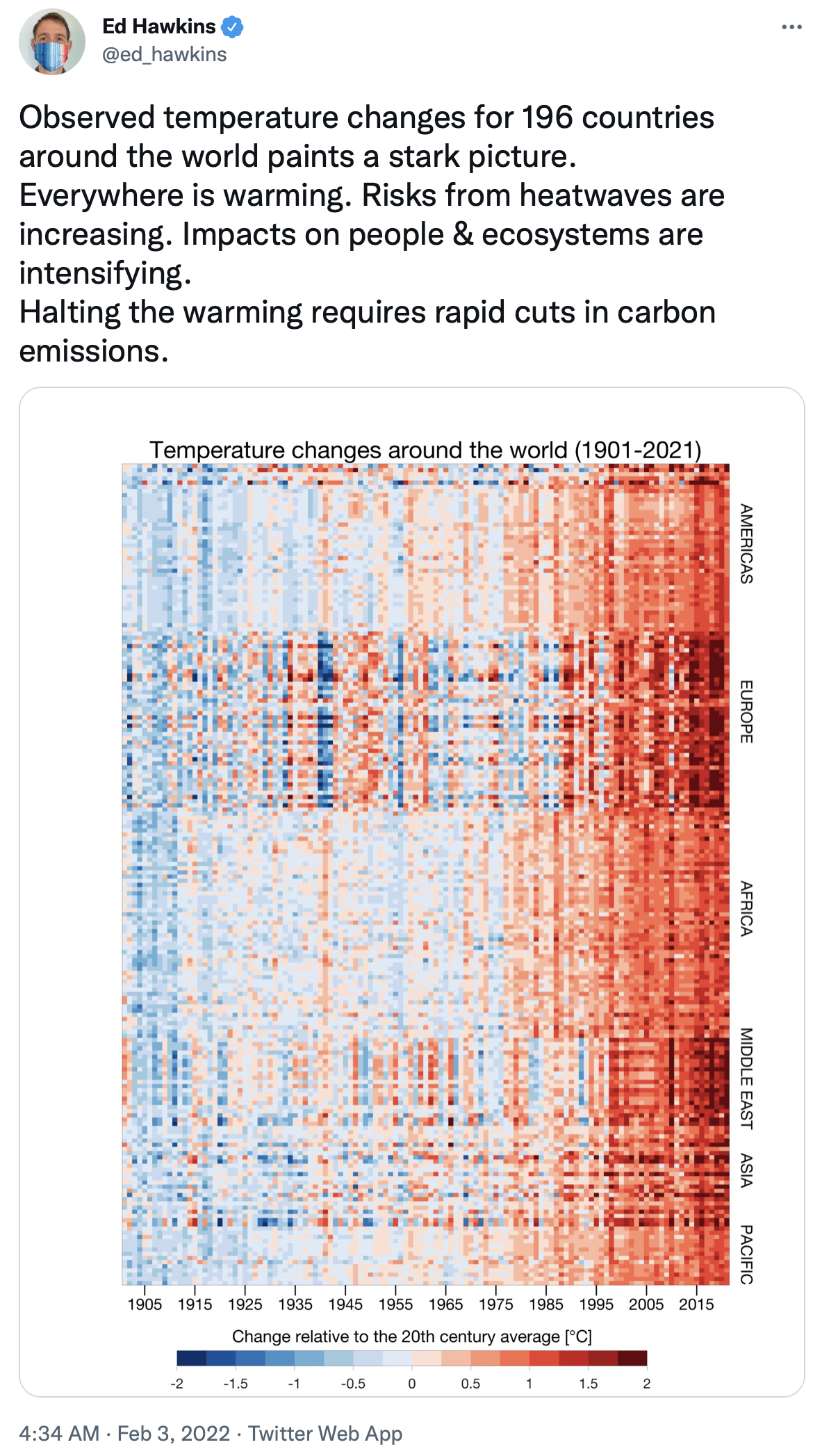
Full and equal access and participation for women and girls in science
Science and gender equality are both vital for the achievement of the internationally agreed development goals, including the 2030 Agenda for Sustainable Development. Over the past decades, the global community has made a lot of effort in inspiring and engaging women and girls in science. Yet women and girls continue to be excluded from participating fully in science.
In order to achieve full and equal access to and participation in science for women and girls, and further achieve gender equality and the empowerment of women and girls, the United Nations General Assembly declared 11 February as the International Day of Women and Girls in Science in 2015.
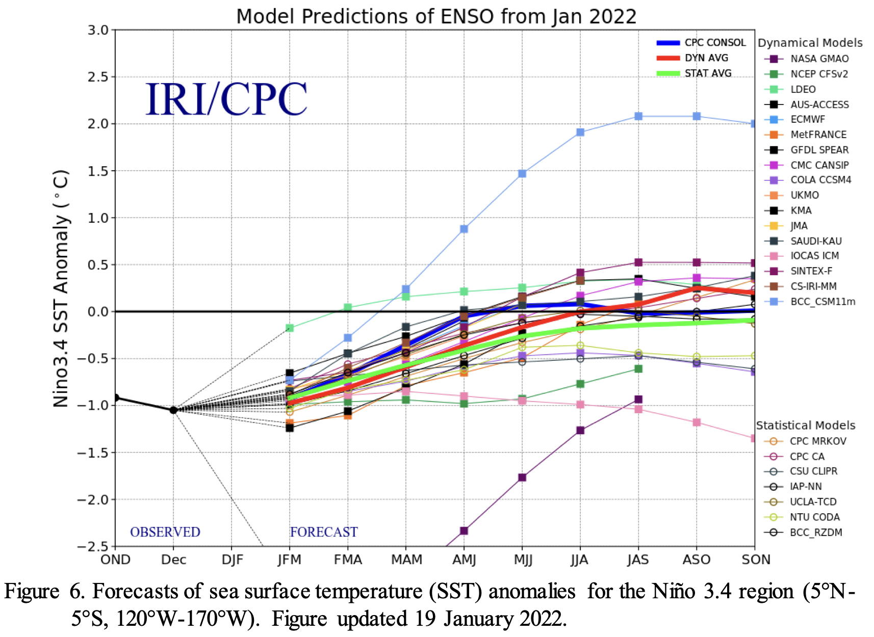
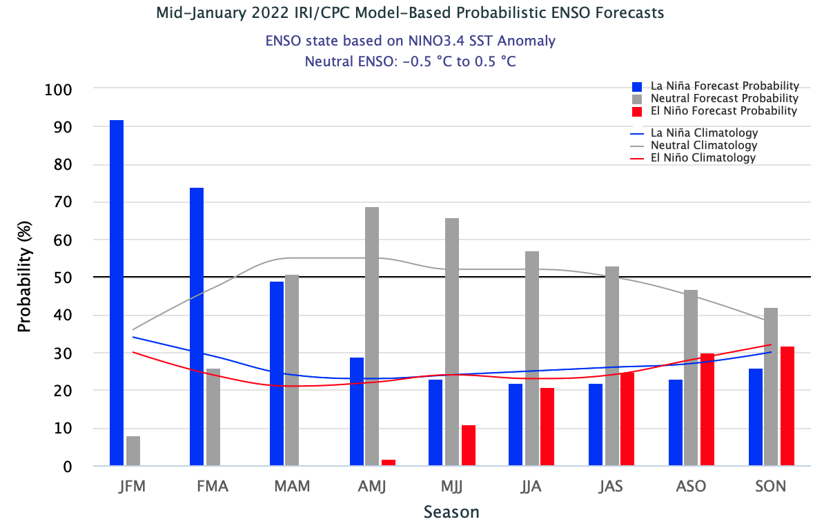
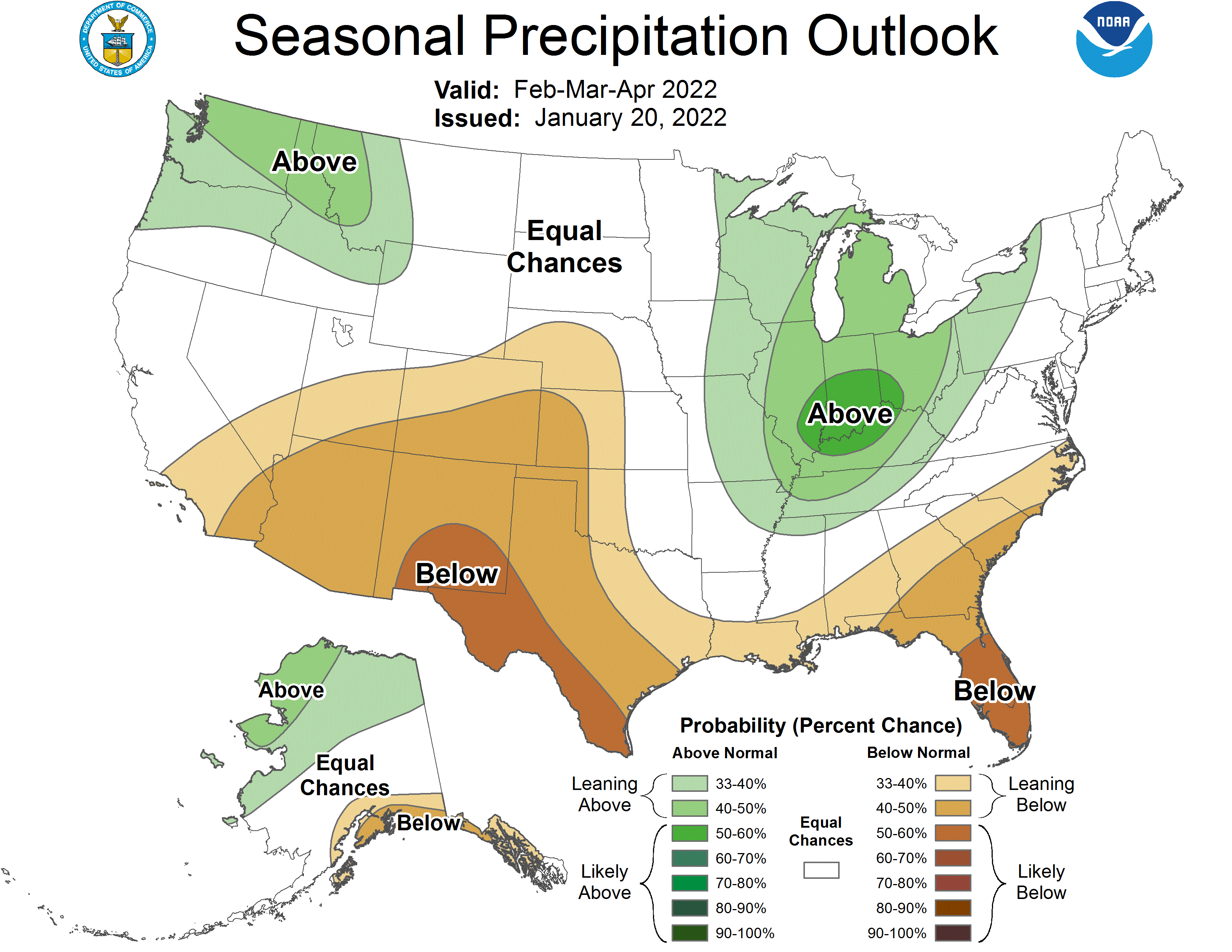
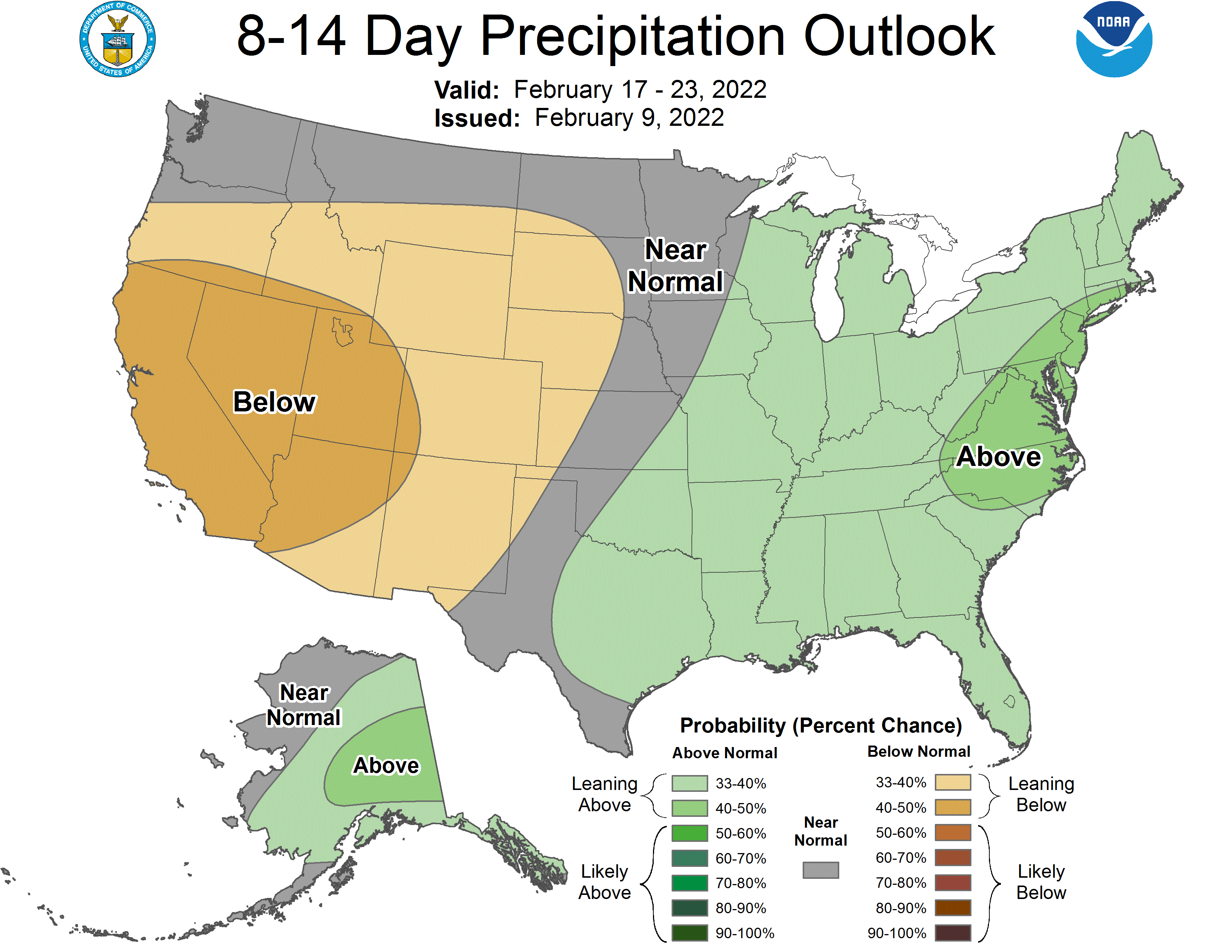
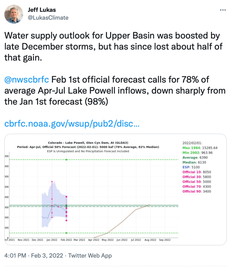
Synopsis: La Niña is likely to continue into the Northern Hemisphere spring (77% chance during March-May 2022) and then transition to ENSO-neutral (56% chance during May-July 2022).
Below-average sea surface temperatures (SSTs) weakened during January 2022, though anomalies stayed negative across most of the east-central and eastern equatorial Pacific Ocean. Most of the weekly ENSO indices remained between -0.5oC and -1.0oC in the last week, except for the Niño-4 index, which was -0.2oC. In contrast, subsurface temperatures (averaged between 180o- 100oW and 0-300m depth) trended to near average during the month. This large change in recent weeks reflected the eastward progression of a downwelling Kelvin wave, as indicated by the extension of above-average subsurface temperatures across much of the Pacific. Below -average subsurface temperatures were confined to the eastern Pacific Ocean at the end of the month. For the monthly mean, low-level equatorial winds were near average across much of the Pacific, while upper-level westerly wind anomalies remained over the east-central Pacific Ocean. Below-average convection strengthened near and west of the Date Line, while convection was near average over Indonesia. Overall, the coupled ocean-atmosphere system reflected a weakening La Niña.
The IRI/CPC plume average for the Niño-3.4 SST index continues to forecast a transition to ENSO-neutral during the NorthernHemisphere spring. Because the easterly tradewinds have recently been strengthening and are predicted to continue in the near term, the forecaster consensus favors those models suggesting as lower decay of LaNiña through the spring. However,ENSO-neutral is still anticipated to return by the Northern Hemisphere summer, although the chance does not exceed 57% duringJune-August 2022, reflecting the uncertainty associated with the spring predictability barrier. In summary, La Niña is likely to continue into the Northern Hemisphere spring (77% chance during March- May 2022) and then transition to ENSO-neutral (56% chance during May-July; click CPC/IRI consensus forecast for the chances in each 3-month period).
La Niña is anticipated to affect temperature and precipitation across the United States during the upcoming months (the 3-month seasonal temperature and precipitation outlooks will be updated on Thurs. Feb. 17th).
La Niña is likely to hang around through the spring, with a transition to neutral favored for the May–July period. Hop in, and we’ll cruise through some updates on current conditions and the recent past!
On the road again
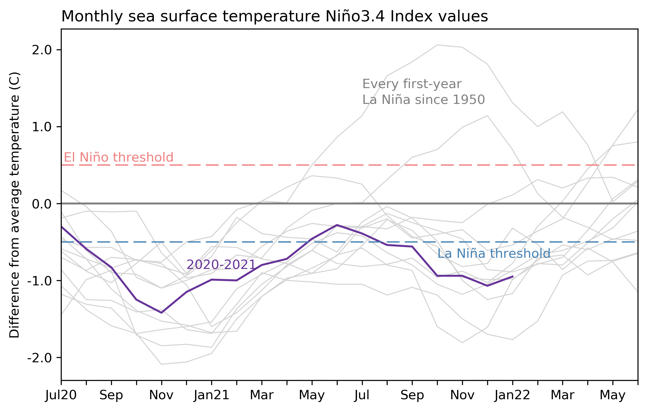
The November–January average Oceanic Niño Index, that is, the three-month-average sea surface temperature anomaly in the Niño-3.4 region of the tropical Pacific, was -1.0 °C. Anomaly means the difference from the long-term average; long-term is currently 1991–2020. This marks our fifth three-month period in a row with an Oceanic Niño Index that exceeds the La Niña threshold of -0.5 °C. Passing this mile marker means this La Niña has persisted long enough to be awarded a bold blue color in our historical table. Congratulations, La Niña 2021–22, already the second La Niña of this young decade.
Monthly sea surface temperature anomalies (difference from average) in the Niño 3.4 region of the tropical Pacific for 2020-21 (purple line) and all other years (gray lines) starting from first-year La Niña winters since 1950. Climate.gov graph based on ERSSTv5 temperature data.
Will there be a third? We still don’t have a very clear picture of that. Right now, there’s a 77% chance that La Niña will last through the spring (March–May), largely based on computer model forecasts and bolstered by a recent uptick in the trade winds. Neutral is most likely for summer (June–August), with a 57% chance. By fall (September–November), neutral still has the edge, but forecasters can’t currently give any category a strong chance.
Every day is a winding road
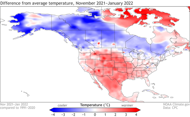
ENSO (El Niño/Southern Oscillation, the entire El Niño/La Niña system) is a seasonal forecaster’s best friend because it changes atmospheric circulation in (somewhat) predictable ways, allowing us to get an early picture of how the average seasonal climate might turn out. For example, during La Niña, the Pacific jet stream tends to be retracted to the west, and high pressure often forms south of Alaska. These effects tend to lead to a colder Northwest/warmer Southeast pattern over North America, along with more rain and snow than average in the Pacific Northwest and Ohio/Tennessee valleys, and drier conditions across the southern tier of states.
Average location of the jet stream and typical temperature and precipitation impacts during La Niña winter over North America. Map by Fiona Martin for NOAA Climate.gov.
I’m sure you noticed all the qualifying words in the previous paragraph. “Somewhat,” “might,” “tends,” etc. Believe me, I wish we could make stronger statements and more confident predictions! But I try to remember that it’s pretty amazing that we can get any idea of what the average weather might be like months into the future, given our complex and wildly chaotic Earth system. La Niña doesn’t guarantee warmer weather in the southeast or dry conditions in southern California—far from it—but it makes those conditions more likely overall.
There’s more that goes into the seasonal forecast than ENSO, of course, like trends, or other climate patterns. Check out Mike Halpert’s post on the winter outlook for an overview of the seasonal outlook process, and a set of maps that illustrate just how much outcomes can vary from one La Niña event to another. That said, ENSO has a big imprint on the seasonal forecast. You can see the Climate Prediction Center’s outlook for November–January 2021–22 here.
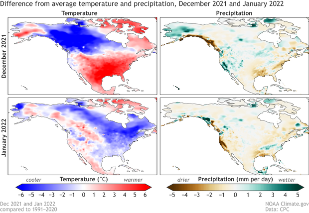
The November–January average temperature ended up looking a lot like what we’d expect during La Niña: colder than average through Canada, warmer over most of the US. Not exactly the same, but reasonably similar.
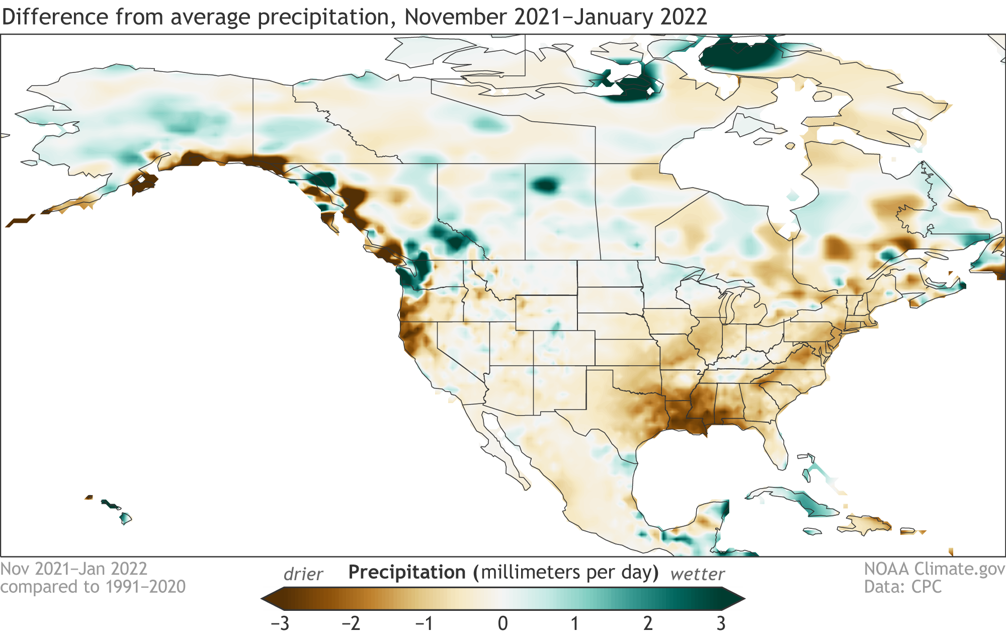
Precipitation difference from the 1991–2020 long-term average during November 2021–January 2022. Precipitation is rain plus the liquid equivalent of snow and ice. Map by climate.gov from CPC Global Daily Precipitation data.
Seasonal climate averages matter—for example, your heating bill is going to reflect if the winter was warmer or colder than average overall. However, sometimes it’s hard to see the forest for the trees, like when you have a December that’s 6° F warmer than average, followed by a hair-pin turn into a January that’s 2° F colder than average. (Hello, Annapolis area!) More on this just a mile down the road.
The precipitation map for November–January also looks a fair bit like the typical La Niña impacts map for this season. Lots of rain and snow in the Pacific Northwest, substantially drier than average through the south-central and southeastern states.
Precipitation difference from the 1991–2020 long-term average during November 2021–January 2022. Precipitation is rain plus the liquid equivalent of snow and ice. Map by climate.gov from CPC Global Daily Precipitation data.
Shut up and drive
If we break December and January out individually, we can see some big changes between the two, especially in temperature, and rain/snow in California. For simplicity, I left out November here. You can toggle between the various months for precipitation and temperature in the IRI Maproom.
Temperature (left maps) and precipitation (right maps) difference from the 1991–2020 average during December 2021 (top row) and January 2022 (bottom row). Maps by climate.gov from CPC Global Daily Temperature data and CPC Global Daily Precipitation data.
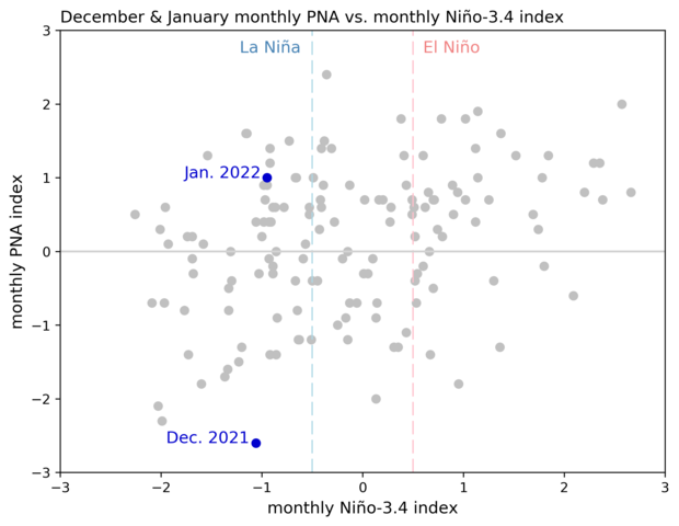
What’s behind these big swings? It’s tough to do a full attribution in the time I have to write my monthly ENSO Blog post, but we do have some thoughts about a culprit. The Pacific-North American pattern (aka the PNA) is a major atmospheric circulation pattern that has a big impact on North American weather. The PNA’s positive phase is primarily characterized by below-average air pressure over the North Pacific and above-average pressure over northwestern North America.
Air pressure in the lower atmosphere compared to the 1981-2010 average during February 2016 (top), when the PNA was positive, and in February 2019 (bottom), when it was negative. The location of highs and lows and the flow of the jet stream around them often produce a sharp warm-cold split in temperatures in the western and eastern halves of the United States. NOAA Climate.gov, based on data from the Physical Science Lab.
The negative phase of the PNA is the opposite: higher pressure south of Alaska, lower pressure over Canada. Be sure to check out Michelle’s post on the PNA, featuring one of our more excellent titles; the PNA Index can be viewed here. During La Niña, the PNA tends to be in its negative phase (that higher pressure over the north Pacific should sound familiar from earlier in this post). However, the PNA can change quickly, so, like the weather, the relationship to ENSO is weaker on a month-to-month basis.
One-month-average Pacific-North America pattern index (vertical axis) versus the one-month-average Niño-3.4 index (horizontal axis) during Decembers and Januarys, 1950–2022. Climate.gov graph from CPC data.
December 2021 featured the strongest negative winter monthly PNA pattern on record (1950–present). Then, in January 2022, the PNA moved into a positive phase, making the largest jump on record from one December to January. Why did the PNA flip? That is a topic for another day. The PNA can be affected by other climate patterns, but, as Michelle says in her earlier post, “a large chunk of the PNA is internally driven.” This means that apparently random, chaotic behavior, aka internal variability, often determines the state of the PNA.
The PNA is forecasted to move back into a more La Niña-consistent negative phase in mid-late February, so this La Niña is not done with us yet. With Nature behind the wheel, we’re all just along for the ride. However, that’s not going to stop us from trying to figure out where we’re going, and how we got where we are! See you next month.
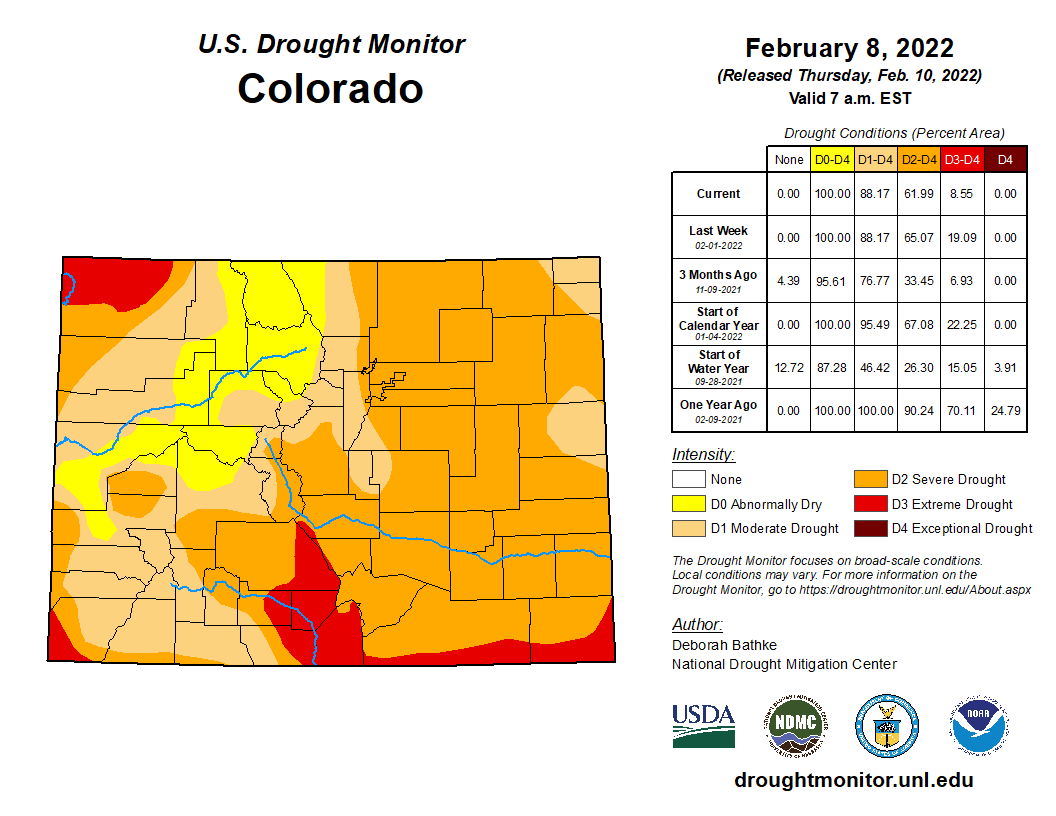
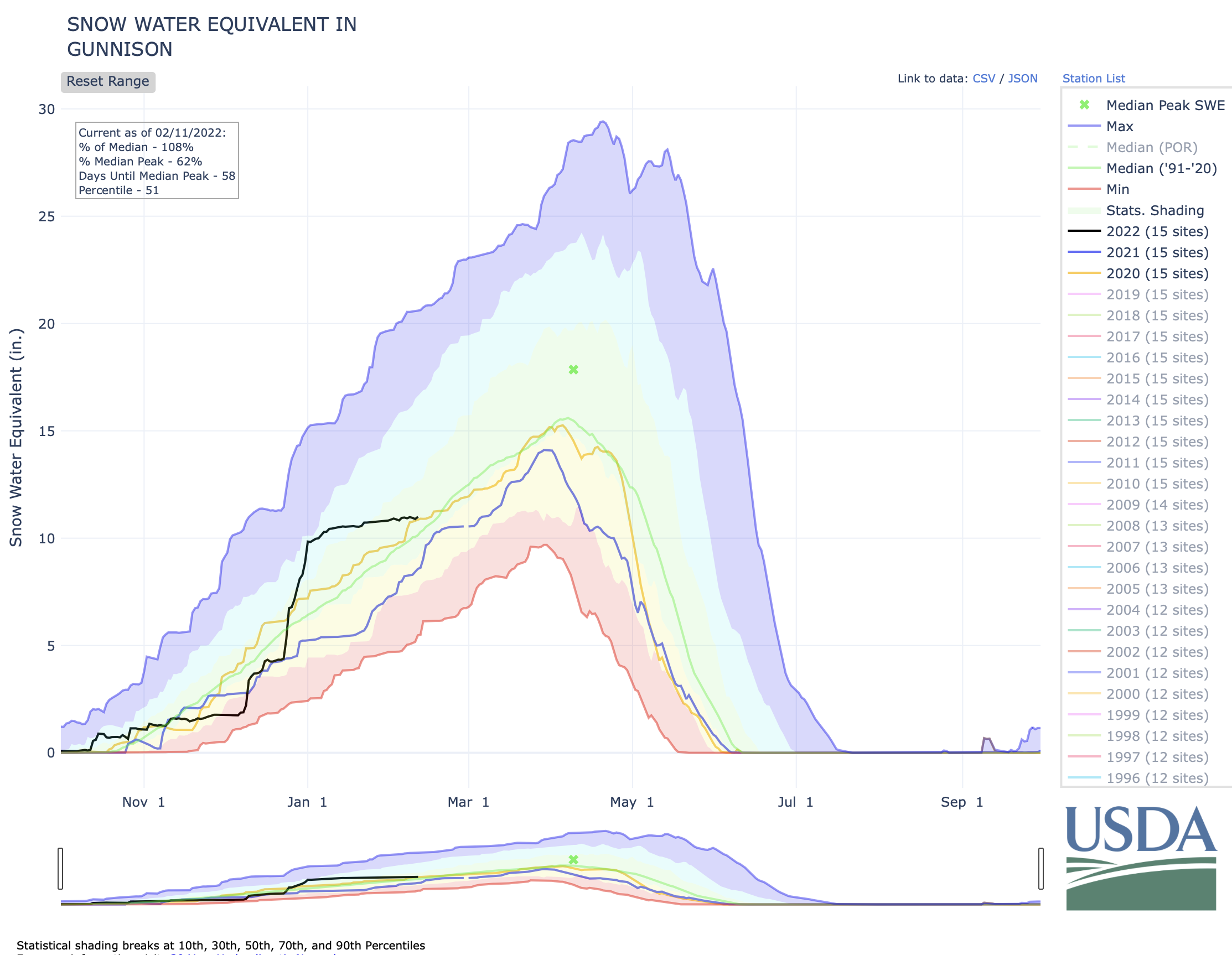
Water experts are monitoring closely how the series of big storms at the end of 2021 and beginning of 2022 will affect local stream runoffs, or if the dry spells since then will continue to counteract the gains made in snowpack and snow water equivalency. Drought conditions have worsened across the state, becoming more widespread and more extreme in general, and a large portion of Gunnison County is now considered ‘abnormally dry.’ That may be the new normal, even with sporadic large snowstorms. However, the runoff forecast for both Blue Mesa and Taylor Park reservoirs look on track to fill up to 90 percent of capacity or more, as of February 1 calculations. No additional emergency releases are expected out of Blue Mesa at this time.
Upper Gunnison River Water District (UGRWD) water resource specialist Beverly Richards gave an overview of the Upper Gunnison Basin water supply as of early February to Gunnison County commissioners during a work session on February 8, and said overall conditions have worsened this water year.
Drought
“There are no areas now in the state of Colorado that have no drought conditions,” she reported. “Last summer there was quite a big area that was considered not in drought, however that is changing slowly and there has been an increase in the area where extreme drought conditions are worsening.”
Areas of the state characterized as in ‘extreme drought’ have increased from 7 percent to about 19 percent since the beginning of the water year on November 1, said Richards…
The entire Gunnison Basin is at 110 percent of normal for snow water equivalent, having fallen from 150 percent of normal. The upper basin has fallen from 160 percent of normal to 118 percent of normal and is expected to fall further unless meaningful precipitation arrives…
Reservoir outlooks
Reservoir storage is up overall in the Gunnison River basin at 52 percent of average, with Taylor Park reservoir standing at 55 percent of capacity as of February 6 and Blue Mesa still at 29 percent of capacity.
Based on early season projections from the Colorado River Basin Forecast Center (CRBFC), the Bureau of Reclamation has projected the total 2022 unregulated inflow into Blue Mesa will be at 825,000 acre-feet, or 90 percent of average. “Hopefully the snowpack will continue to grow so that we do actually see that,” said Richards.
At Taylor Reservoir, the CRBFC has forecasted runoff into the reservoir to be 1000,000 acre feet, which is 106 percent of average. The Taylor is projected to be 93 percent full after runoff, which is considerably higher than last water year. “The next couple of months, the forecast is going to be really important,” said Richards, as releases will be planned and adjusted based on those.
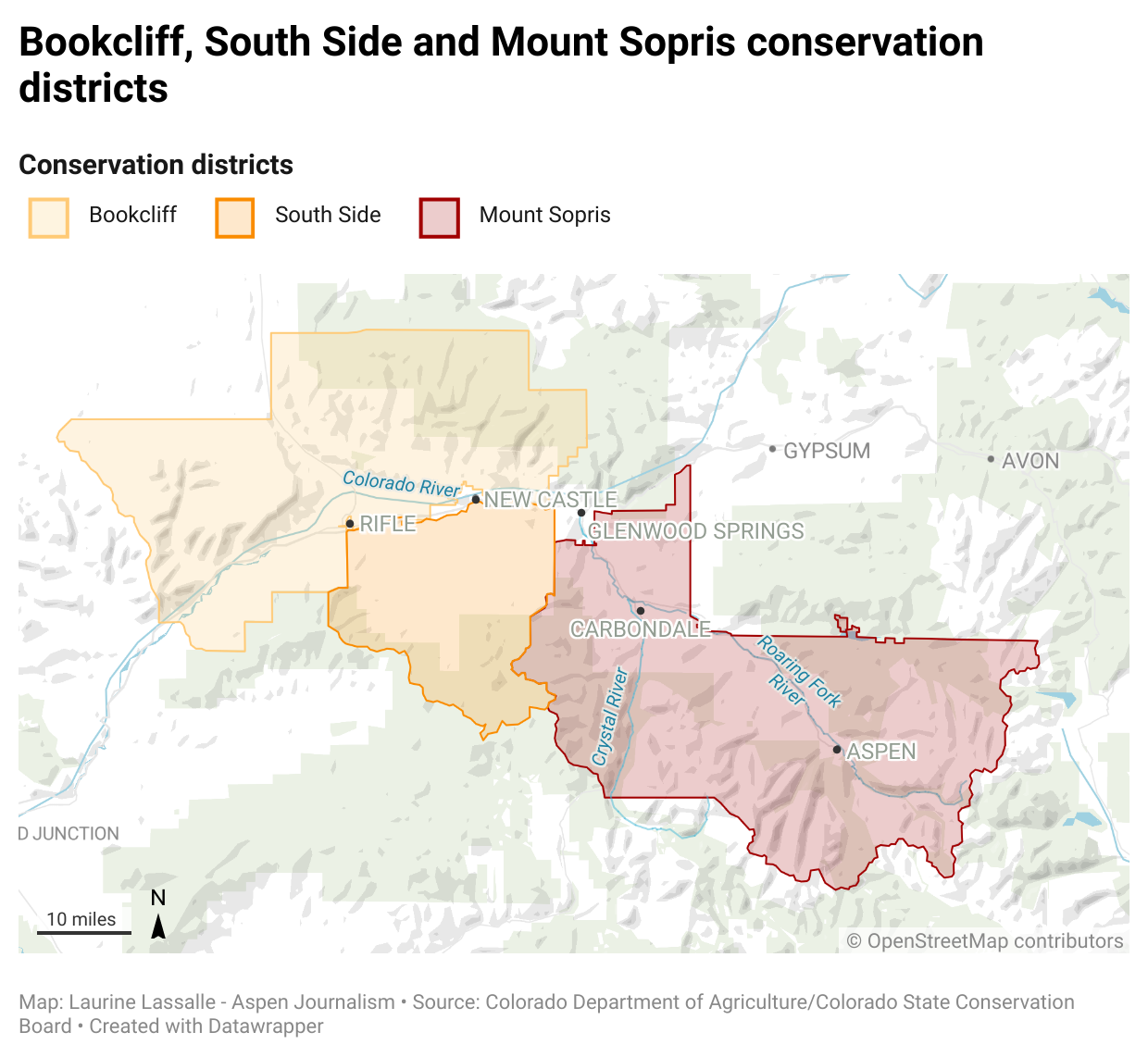
RENEWABLE Water Resources promoter Sean Tonner touted a $50 million community fund in his pitch to Douglas County commissioners Monday to support a plan to move water from the San Luis Valley to Douglas County.
San Luis Valley farmers countered with figures that showed an annual loss of $53 million, or 5 percent, to the Valley’s economy from dried-up irrigated land resulting from the acre-feet of water that RWR wants to pump out of the San Luis Valley on an in-perpetuity basis.
In their fourth work session studying a possible investment in the RWR plan, Douglas County commissioners heard differing views on the economic impact of pumping water from the San Luis Valley to Douglas County. At this point Douglas County isn’t sure how much of its federal COVID relief money it can invest in the RWR plan, or what it actually gets for the money.
The work session also raised questions around Douglas County’s motivation, since it is not a water utility and doesn’t have water customers, and why Douglas County is intently focused on the RWR plan rather than other water projects closer to Douglas County that also have been submitted.
“Why are you doing this and not talking about the Platte Valley Water Partnership with as much gusto?” said Heather Dutton, manager of the San Luis Valley Water Conservation District. She was referencing a proposal to Douglas County from neighboring Parker Water and Castle Rock Water on a renewable water supply through the Platte Valley Water Partnership.
“We are actively looking at all of the proposals,” said Douglas County Commissioner Abe Laydon.
Douglas County also received a letter from the San Luis Valley Board of County Commissioners voicing their opposition: “The proposal from RWR is a threat to the life we are already struggling to maintain. Frankly, we think the use of Federal funds to take the livelihood from an area whose median income is $37,663 to increase the population of Douglas County, median income $119,730, is insulting.”
The work session on the economic impact from the RWR proposal was similar to the previous work sessions covering other topics: Little agreement on the impact 70 years of groundwater pumping and 20 years of drought have had on the Upper Rio Grande Basin, and growing hostilities between RWR pitchmen and San Luis Valley farmers and water managers.
At one point, Douglas County Commissioner George Teal, who during his run for county commissioner benefited from RWR-related campaign donations and now supports the RWR plan, grew testy with Conejos County farmer James Henderson. Teal said he took offense at statements last week by Nathan Coombs, also from Conejos County, when Coombs said ag operations in the San Luis Valley were taking a back seat to unchecked growth in Douglas County.
“It’s almost like, ‘What makes the San Luis Valley more valuable than the agricultural interests in Douglas County?’” said Teal.
Tonner said the proposed community fund would bring a needed infusion of money to help address a myriad of problems he sees in the San Luis Valley, from the lack of restaurants and hotels to the distance he has to travel to find a gas station.
“I have to drive almost 40 minutes to get gas,” Tonner said. Finding a restaurant to eat at is another challenge of his, he said. “It gives you some context of what a community fund like this can do for everyone,” he said.
Henderson and Chad Cochran provided the commissioners with figures on the market value of the crops grown in the San Luis Valley to highlight the damage to the Valley’s ag economy that would come with exporting water from the drying Rio Grande.
“How does the value of land go up when there’s not water,” said Cochran, challenging RWR’s assumption that its plan won’t harm the Rio Grande. “It’s a dust bowl.”
He wasn’t at the meeting with Douglas County commissioners, but retiring 12th Judicial District Court Judge Martín Gonzales perfectly framed what’s at stake in the San Luis Valley’s latest battle to stop a water exportation plan when he talked earlier to AlamosaCitizen.com.
“In my mind the seminal struggle for the Valley is water,” Gonzales said. “I think it’s important to keep agriculture alive. I think it’s important to have the water to keep it alive, kept in the Valley. That’s in my mind the seminal struggle by which I define as ‘If you don’t win that, you may not win anything else.’”
As a part of their process to evaluate a multimillion-dollar proposal to pump water into Douglas County, the Douglas County commissioners on Jan. 31 heard presentations from advocates and farmers from the place the water would come from: the San Luis Valley in south central Colorado.
Speakers from the San Luis Valley Conservancy District, the Conejos Water Conservancy District and the Rio Grande Water Conservation District spoke to the commissioners with one main message: this plan would damage their community.
“We are struggling to keep our ship correct and to try to recover our aquifer and then here comes this seemingly predatory-natured entity to exacerbate our problem when we’re in the middle of a hardship,” said Nathan Coombs, the district manager for the Conejos Water Conservancy District.
Representatives from Renewable Water Resources, a water developer, also sat in the room, defending the proposal at times. One of the representatives, Jerry Berry, is a farmer from the San Luis Valley and spoke in support of the proposal, which would ask some valley residents to sell their water rights and promises to contribute $50 million to the community to use as they see fit.
The two-hour meeting was one of seven that the board plans to hold to evaluate the controversial proposal, which would use a portion of the $68 million in federal money given to the county from the American Rescue Plan Act. In March, commissioners plan to travel to the San Luis Valley to hear from locals about the plan.
While RWR originally proposed that the county pay an initial fee of $20 million for the project followed by a cost of $18,500 per acre-foot for water, they recently revised that request.
In a letter to commissioners dated Jan. 27, RWR said that their attoreys recently informed them that “the rules and regulations governing the use of ARPA funds may not allow the county to spend $20 million on projects that are not completed by 2026,” according to the document provided to Colorado Community Media by the county.
If those restrictions remain, RWR suggests that the county instead pay an initial amount of $10 million from the general fund for the project with a cost of $19,500 per acre-foot. They say they believe the county could then use $10 million from ARPA to backfill the general fund.
During the meetings evaluating the project, proponents and opponents have sparred over whether or not the plan would be harmful to the San Luis Valley, a huge area that relies on agriculture as a primary source for its local economy.
So far, the commissioners have also heard presentations from RWR, the Colorado Division of Water Resources and from various water lawyers.
The northern end of Colorado’s San Luis Valley has a raw, lonely beauty that rivals almost any place in the North American West. Photo/Allen Best
The Platte River is formed in western Nebraska east of the city of North Platte, Nebraska by the confluence of the North Platte and the South Platte Rivers, which both arise from snowmelt in the eastern Rockies east of the Continental Divide. Map via Wikimedia.
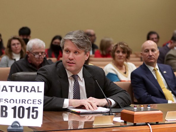
A canal would divert South Platte River flows from Colorado to Nebraska under a bill heard Feb. 9 by the Natural Resources Committee.
LB1015, introduced by Speaker Mike Hilgers of Lincoln at the request of Gov. Pete Ricketts, would authorize the state Department of Natural Resources to develop, construct, manage and operate the canal and its associated storage facilities, called the Perkins County Canal Project, under the terms of the South Platte River Compact.
The bill also would authorize the department to use eminent domain to acquire land and resolve any legal disputes that arise as a result of the project.
The 1923 compact between Nebraska and Colorado apportions flows of the South Platte River between the states.
Nebraska Senator Mike Hilgers at Natural Resources Committee hearing February 9, 2022. Photo credit: Unicameral Update
Hilgers said the agreement entitles Nebraska to 120 cubic feet of water per second from the river during the summer. It also allows Nebraska to divert 500 cubic feet of water per second during the non-irrigation season if the state builds a canal, he said.
If Nebraska does not act to preserve its rights under the compact, Hilgers said, development along Colorado’s Front Range could “capture” those winter flows.
“This will certainly jeopardize our existing water uses and force us to seek more expensive and less certain water supplies,” he said.
Ricketts testified in support of LB1015, saying reduced South Platte River flows would affect irrigated agriculture, hydroelectric generation, endangered species protection and drinking water supplies for communities along the Platte River, including Lincoln and Omaha.
Compared to the economic cost of losing that water, he said, the $500 million canal and reservoir system would be a “bargain.”
Tom Riley, director of the state Department of Natural Resources, also testified in support. If Colorado follows through on proposed water management projects, he said, 90 percent of the South Platte River flows that Nebraska receives would be lost.
Building the canal would secure Nebraska’s right to the South Platte River’s winter flows “in perpetuity,” Riley said. If the Legislature authorizes the canal, he said, construction could begin as early as 2025, and it could be in use within a decade.
“In my 35 years as a water resources engineer practicing in the field, I have never seen a more important water project for Nebraska,” Riley said.
Testifying in opposition to the bill was Al Davis of the Nebraska chapter of the Sierra Club. He said further changes to the Platte River’s flow would affect the many species of birds, fish and mammals that rely on the river.
Davis questioned whether the project is viable and said it could be delayed by lawsuits. He said the proposed funding could be put to better use by retiring irrigated acres in overappropriated river basins and giving grants to farmers to help them reduce the amount of water they use.
“There are far too many unanswered questions to tie up $500 million for decades when that money could be used for an immediate benefit of Nebraskans,” Davis said.
Katie Torpy gave neutral testimony on behalf of the Nature Conservancy. She said colleagues in Colorado told her its list of proposed water management projects is a “brain dump” and that Colorado does not intend to pursue them all.
Torpy questioned whether Nebraska has exhausted all avenues to secure its rights under the compact. She said understanding how the proposed canal and reservoir system would affect the Platte River’s natural flow is “paramount” before moving forward.
The committee took no immediate action on LB1015.
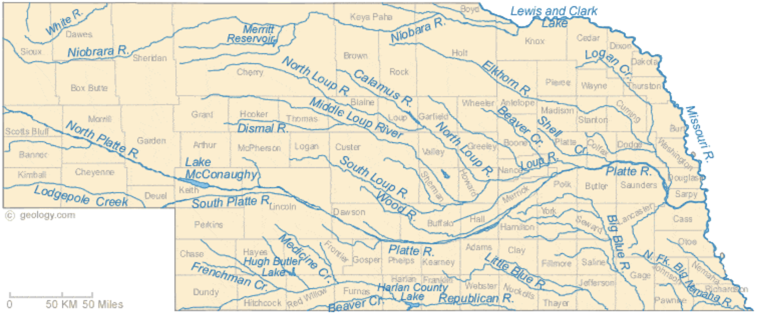
Nebraska Rivers Shown on the Map: Beaver Creek, Big Blue River, Calamus River, Dismal River, Elkhorn River, Frenchman Creek, Little Blue River, Lodgepole Creek, Logan Creek, Loup River, Medicine Creek, Middle Loup River, Missouri River, Niobrara River, North Fork Big Nemaha River, North Loup River, North Platte River, Platte River, Republican River, Shell Creek, South Loup River, South Platte River, White River and Wood River. Nebraska Lakes Shown on the Map: Harlan County Lake, Hugh Butler Lake, Lake McConaughy, Lewis and Clark Lake and Merritt Reservoir. Map credit: Geology.com
Leaders from Nebraska’s irrigation and natural resources districts cast the plan as a crucial step to preserve as much of the state’s water supply as possible.
Republican Gov. Pete Ricketts identified it as a top priority, arguing that not moving forward would eventually cost Nebraska billions as farms, cities and other water users struggle with shortages.
Colorado officials say they don’t fully understand Nebraska’s concerns, noting that they’ve always complied with the compact.
People work on the Perkins County Canal in the 1890s. The project eventually was abandoned due to financial troubles. But remnants are still visible near Julesburg. Perkins County Historical Society
That was the refrain being sung before the Nebraska Legislature’s Natural Resources Committee Wednesday as state officials tried to persuade the senators to approve building the Perkins County Canal…
Proponents all told the committee that the Perkins Canal must be built as soon as possible, or Nebraska will never be able to claim the water it has a right to. Riley told the committee the canal is “central to water security in Nebraska. I’ve never seen a more important project. To fail to build this project now would be catastrophic.”
The now-or-never urgency of the canal is predicated on the assumption that Colorado water storage projects will soak up all but the absolute minimum flow required by the compact. Colorado officials estimate that even in a dry year, 10,000 acre feet of water escapes into Nebraska, beyond that which is required by the compact. Between 1996 and 2015, Colorado delivered to Nebraska nearly 8 million acre feet of river water, for an average of more than 400,000 acre feet per year.
Nebraska officials were quick to point out Wednesday that that’s water Nebraska counts on for irrigation, recreation and even municipal use. Ricketts told the committee that Colorado’s plans for water development and storage threaten to choke off that water supply.
“They’ve listed 283 projects, at a cost of $90 billion, and that includes projects already approved and underway,” Ricketts said. “That would eliminate 90 percent of the (winter time) stream flow coming into Nebraska. It would devastate our economy.”
Riley said he’s talked personally with Coloradans who vow they’ll “not let one drop beyond the Compact (rights) come into Nebraska.”
Asked if the canal project would increase Nebraska’s water supply, Riley said it won’t, but it will protect the water Nebraska gets now. And, because there’s no minimum specified for the non-irrigation season — essentially October to April — it would be possible for Colorado to dry up the South Platte River.
Kent Miller, manager of the Twin Platte Natural Resources District in North Platte, told the committee that’s the intent of Colorado’s water community…
Committee members grilled the witnesses on the absolute necessity of the canal and were clearly concerned about the $500 million price tag attached to it. When Riley testified that Nebraska needed to prove to Colorado that they were going to build the canal, he was asked whether perhaps $200 million would be convincing enough, at least to begin with. Riley said the funds need to be secured immediately because costs will escalate as time goes on.
Only one person spoke in opposition to the bill. Al Davis, legislative director for the Nebraska Sierra Club, said the project would interfere with the timing and flow of the river, and would have a negative impact on habitat. He suggested that, instead, the $500 million be spent on things like child care and infrastructure.
Platte River Recovery Implementation Program target species (L to R), Piping plover, Least tern, Whooping crane, Pallid sturgeon
Melissa Mosier, vice chair of the Land Advisory Committee for the Platte River Recovery Implementation Program, testified in a neutral position on the bill, but expressed concern that the canal project could disrupt the work done by the PRRIP board, of which Tom Riley is a member…
Katie Torpy, climate and energy policy lead for Nature Conservancy of Nebraska, also testifying in a neutral position, told the committee that her Colorado contacts led her to believe that Colorado has no intention of pursuing all of the 283 projects to which the bill proponents kept referring.
Governor Clarence J. Morley signing Colorado River compact and South Platte River compact bills, Delph Carpenter standing center. Unidentified photographer. Date 1925. Print from Denver Post. From the CSU Water Archives
NEBRASKA’S LAST BEST CHANCE TO SAVE THE SOUTH PLATTE RIVER
The Platte River, including the South Platte River tributary, runs about 400 miles through the heart of Nebraska from its western border with Colorado to the Missouri River. In Nebraska, the basin supports a population of well over one million people, including Lincoln and portions of Omaha. The river provides water for more than a million acres of irrigated agriculture, produces up to 140 megawatts of hydropower, provides cooling water for Gerald Gentleman Station – Nebraska’s largest power plant, sustains multiple threatened and endangered species, and generates countless recreational opportunities. It is arguably Nebraska’s most precious natural resource. Now, it faces an imminent threat.
Colorado’s South Platte River basin population is expected to
increase from 3.8 to as much as 6.5 million by 2050 (more than three times the population of our state today). Seventy thousand people move to the Front Range region every year. To support this explosive growth, Colorado’s legislature commissioned a study in 2016 to identify every drop of water “in excess of that required” to be delivered to Nebraska under the 1923 South Platte River Compact. Today, Colorado has nearly 300 projects in various phases of completion, planning, and assessment, all with the singular aim of preventing this “excess” water from reaching the state line.
Every drop of South Platte water that fails to reach Nebraska’s state line will need to be made up from storage in Lake McConaughy on the North Platte River. This means lake levels will be lower, carbon-free hydropower production will decrease, and storage supplies needed to mitigate drought within the Platte River Basin will be less reliable.
This growing threat led the editorial boards of the Lincoln Journal Star and Omaha World Herald, in the summer of 2019, to call upon State officials to protect Nebraska’s South Platte rights, echoing what we in the basin already knew – Colorado was coming for our water. But what could be done? To address that question, the Nebraska Legislature appropriated $350,000 in 2020 to study Colorado’s upstream development and its potential impact on Nebraska. The proposed Perkins County Canal Project is, in part, the culmination of that and other efforts by basin stakeholders to ensure Nebraska gets what it’s owed on the South Platte.
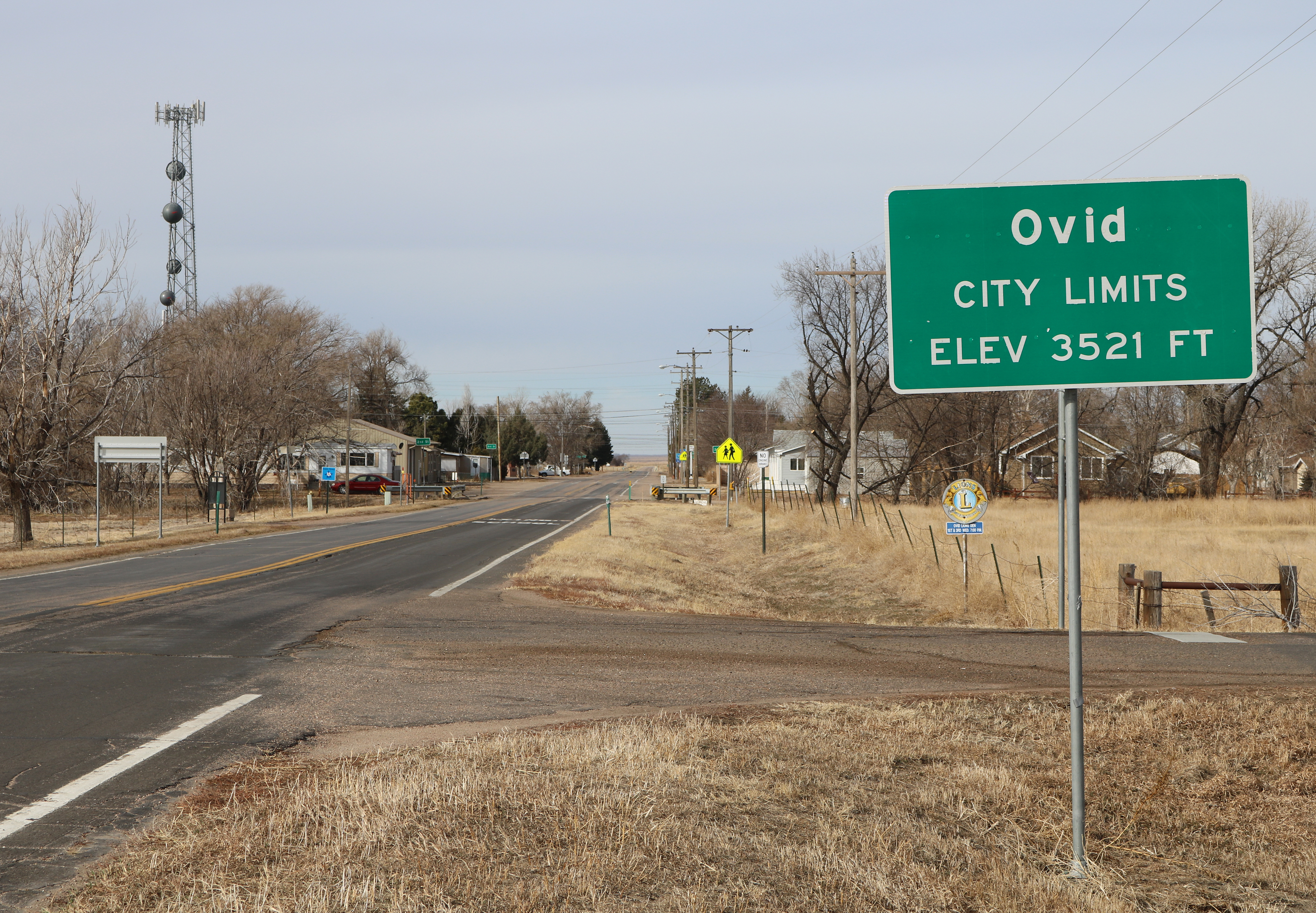
Most in the basin understand the 1923 Compact provides for a flow of 120 cubic feet per second (cfs) during the irrigation season. Many people have just recently learned the Compact also allows Nebraska to divert 500 cfs in the non-irrigation season. This right can only be enforced in priority, however, if Nebraska constructs a diversion near Ovid, Colorado to transport the water to Nebraska, as authorized by the Compact. For over 100 years building this diversion has been deferred, and as a result, Colorado has been taking the water Nebraska is not demanding. The proposed canal will allow Nebraska to fully exercise its Compact rights for the first time since the Compact was signed.
Beneficiaries of this multi-purpose project will include water users across the entire Platte River Basin. This includes those reliant on the Platte River to irrigate crops and those who rely on hydropower to light their homes and businesses. It also includes small and large municipalities that draw water from the Platte River but need more reliable water supplies to attract new industries and promote Nebraska’s future growth and development.
Some have claimed that even if constructed, such a project would yield too little water to justify itself. This is contrary to the available hydrologic data. Colorado itself has stated that over 300,000 acre-feet of “excess” flow enters Nebraska annually – water the new canal would help to protect for Nebraska. Critically, if the project is not built, Colorado can simply cut off this supply. To safeguard against this, Nebraska’s proposed project would capture the bulk of this water, deliver it to a series of reservoirs for temporary storage, and return it to the river.
Some say the project is too complicated and fraught with legal challenges. However, Nebraska’s entitlement to this water is cast in law by the two state legislatures and by Congress. Rarely is a legal right so clear and compelling. Moreover, for a century, we have been able to work cooperatively with Colorado in administering the Compact during the irrigation season. There is every reason to believe our State officials will continue to do so. Ultimately, if litigation became necessary, what alternative do we have? If Colorado develops as projected, it will reduce flow in the South Platte by 90%, forcing Nebraska to search out more expensive and less certain alternative supplies. We can’t simply abandon our water rights.
Some fear such a project could harm key species by reducing flows to the river. The opposite is true. If Nebraska fails to assert its rights on the South Platte, less water will cross the State line. By protecting our non-irrigation season rights, Nebraska will ensure South Platte flows are maintained in the key stretches of the river that support these species and their habitats. Indeed, the project would aid in species recovery by offering water managers greater flexibility to deliver water at times and locations needed to maximize wildlife benefits. This makes it easier for Nebraska users to remain in compliance with their obligations under the Endangered Species Act and the Platte River Recovery and Implementation Program.
South Platte River Storage Study Area. Illustration shows water availability, in blue circles, compared with demand at various places along the South Platte River. The yellow area is the study area. (Illustration by Stantec).
Finally, some argue the price tag is too high. Certainly a $500 million investment must be carefully assessed and evaluated. But, to put that figure in context, our neighbors are planning to spend approximately twenty times that amount ($10 billion) to access the same water we would divert through the project. One of the projects Colorado has identified as most critical would cost $800 million alone, piping tens of thousands of acre-feet of South Platte water every year about 150 miles uphill to the Parker area near Denver. Colorado understands the value of what’s at stake; we can’t afford to be pennywise and pound foolish while our water is diverted away from the river and from future generations of Nebraskans. The time to act is now. The South Divide Canal is our last best chance to protect and preserve the South Platte River in Nebraska.
Western Irrigation District
Twin Platte Natural Resources District
South Platte Natural Resources District
Central Platte Natural Resources District
Nebraska Public Power District
Central Nebraska Public Power and Irrigation District
In 1889, the stretch of the South Platte River in Perkins County, Nebraska was a threadbare nothing.
In an old newspaper clipping from the Grant-Tribune Sentinel, the county’s elected surveyor Mark Burke described what he saw once he arrived in Grant, Nebraska in the 1880s.
“After the ‘June Rise,’ the water disappeared entirely and the river channel became a waste of dry river sands without islands or vegetation,” Burke wrote.
He was the original mind behind the South Divide Canal, now known as the Perkins County Canal…
In the 1923 South Platte River Compact, Nebraska is guaranteed water during the irrigation season. Burke wanted to bank on water coming in during the off-season too…
Capability and feasibility are a few of the bigger questions from some water experts, such as Joel Schkneekloth, a water specialist at Colorado State University.
“It was something I had never heard of. A few people here have in Colorado. They know of it. They hear it once in awhile get popped back up,” Schneekloth said…
Burrowing through sandy southwestern Nebraska soil, the canal may need to be lined, which makes for a costly water project.
“Through talking and discussing with other people… they were going to have to cross a fairly sandy stretch to get out of the South Platte River. Sand and water would make for very low conveyance,” Schneekloth said.
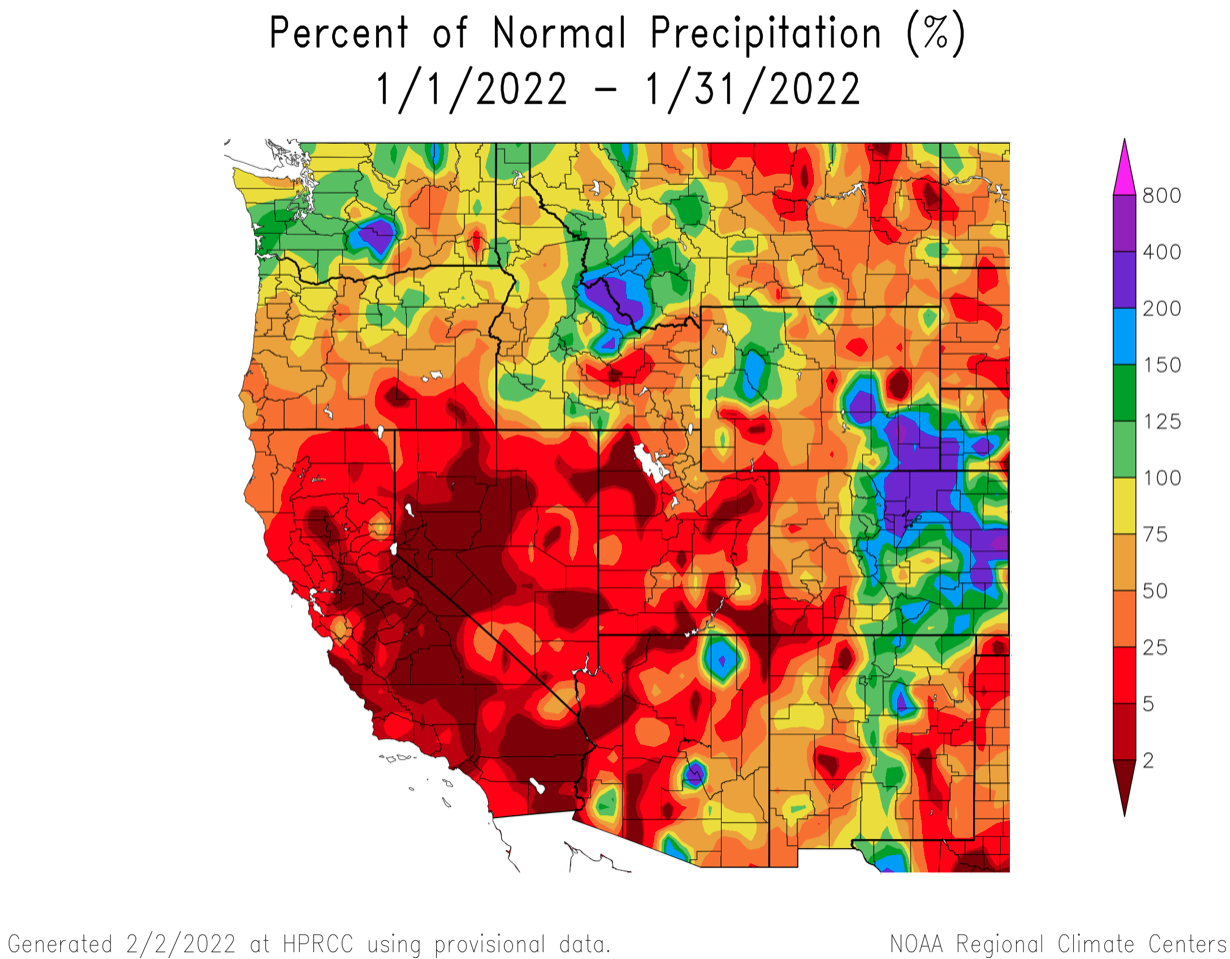
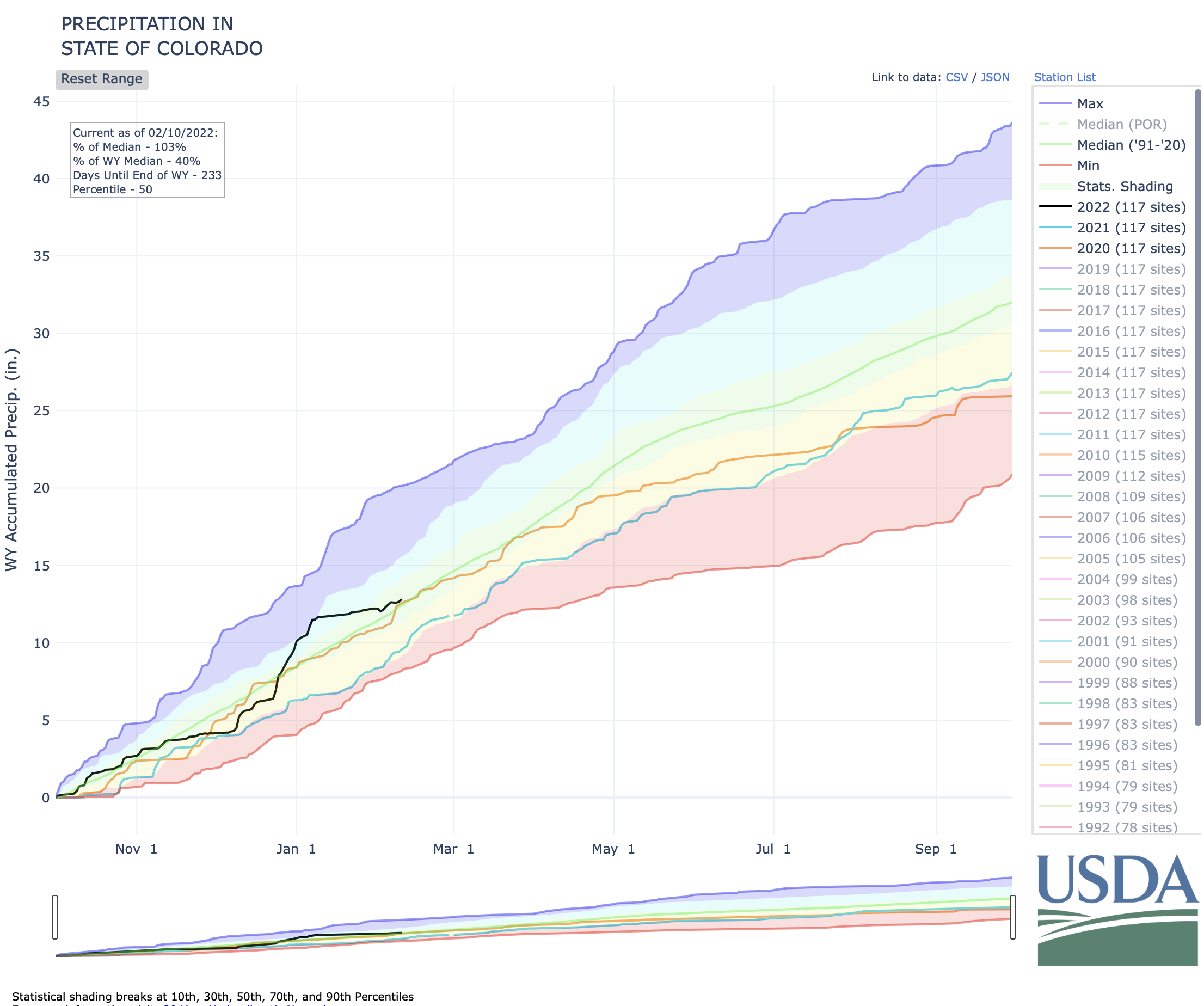
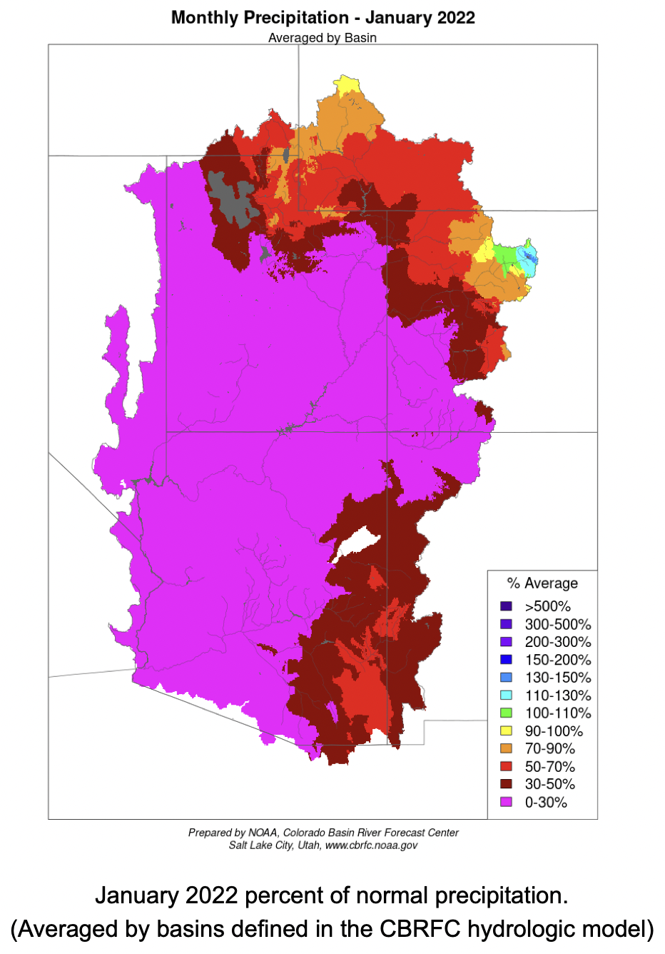
January was very dry throughout most of the region; snowpack and streamflow forecasts that were much above average on January 1st dwindled to near-to-below average conditions by February 1st. Drought conditions remain over nearly the entire region and continued La Niña conditions are projected to bring below average precipitation and above average temperatures to Colorado and Utah for the remainder of winter.
January precipitation was below average for much of the region, especially in Utah where large portions of the state received less than 50% of normal precipitation. In Colorado, January precipitation was below average west of the Continental Divide and above average east of the Divide, especially in the eastern Plains. Much above average precipitation as observed in southeastern Wyoming and in the Wind River Range.
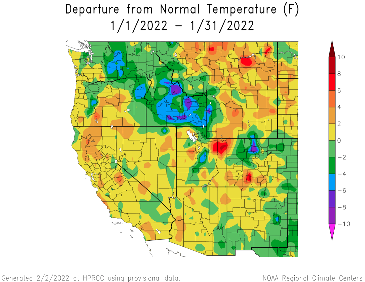
Temperatures were near average (+/- 2 degrees) for much of the region. Warmer than average January temperatures were observed in the Uintah Basin in Utah and west-central Wyoming. Below average temperatures were observed in western Wyoming, northern Colorado and eastern Colorado.
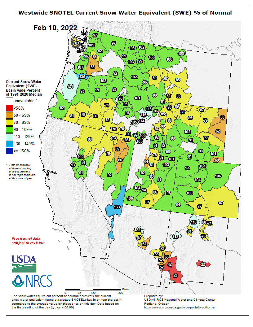
Despite a dry January, regional snowpack remains near average in most river basins of the Intermountain West. Snowpack declined relative to average in all river basins in Utah and Colorado, except for the South Platte River Basin. In Colorado, snowpack remains above average in the North Platte, South Platte and Gunnison River Basins, but is below average in the Rio Grande and Arkansas River Basins. Snowpack is below average in northeastern Wyoming, but near average in the remainder of the state.
Westwide SNOTEL basin-filled map February 10, 2022 via the NRCS.
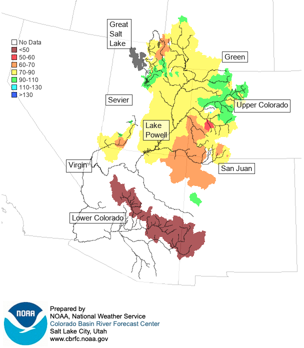
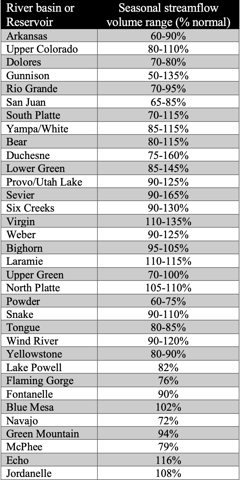
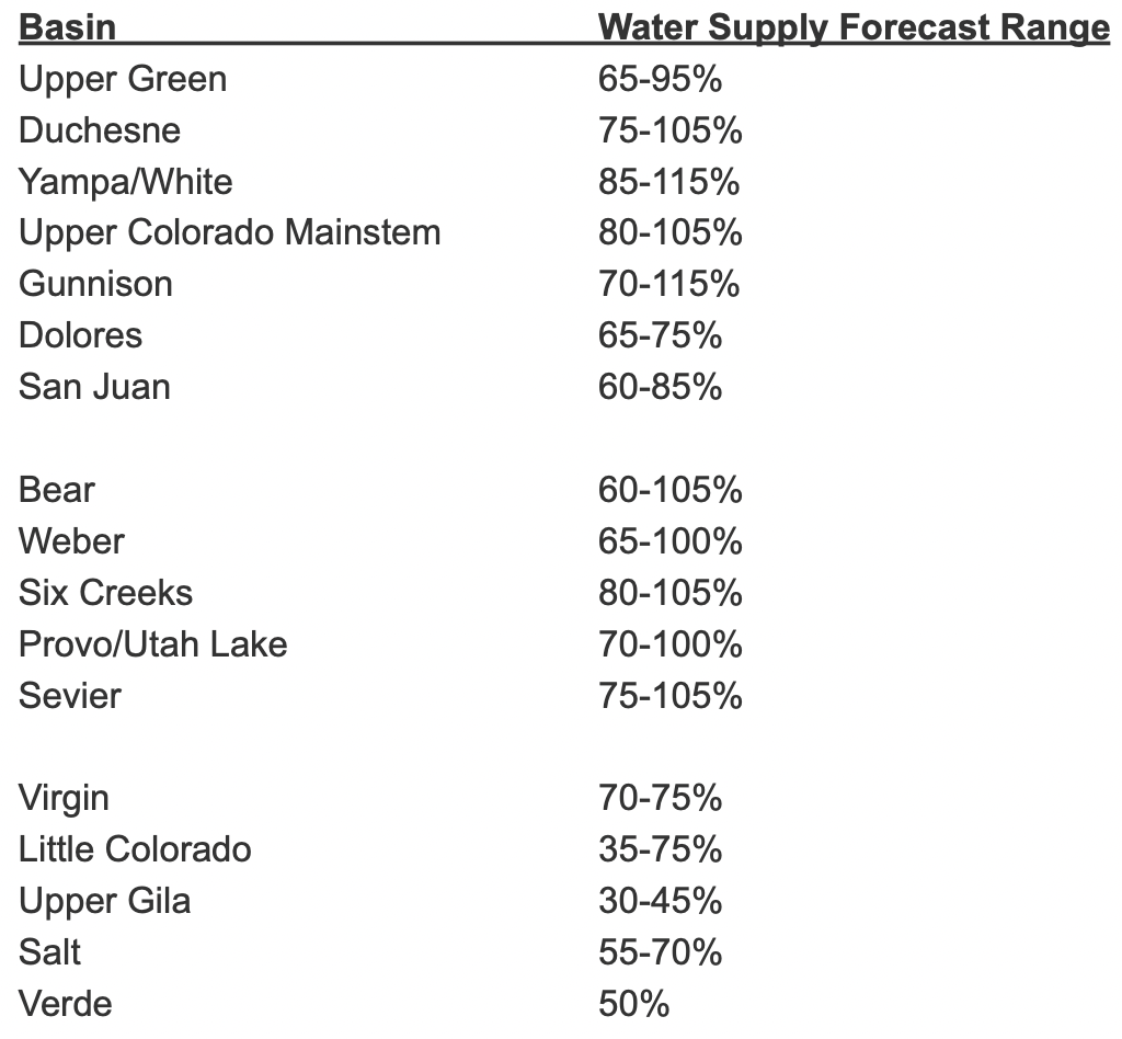
Dry conditions during January resulted in a decrease in seasonal streamflow forecasts relative to average except in the Bear, Upper Green, South Platte and Wind River Basins. Near-average streamflow volumes are forecasted for the Mainstem of the Colorado, Laramie, North Platte, Provo, Six Creeks, Upper Snake, South Platte, Weber and Upper Yampa River Basins. Above average streamflow is forecasted for the Virgin River Basin. Most other regional river basins are forecasted to see below normal seasonal streamflow volumes, with the Arkansas, Dolores, Powder and San Juan River Basins forecasted to see the lowest flows.
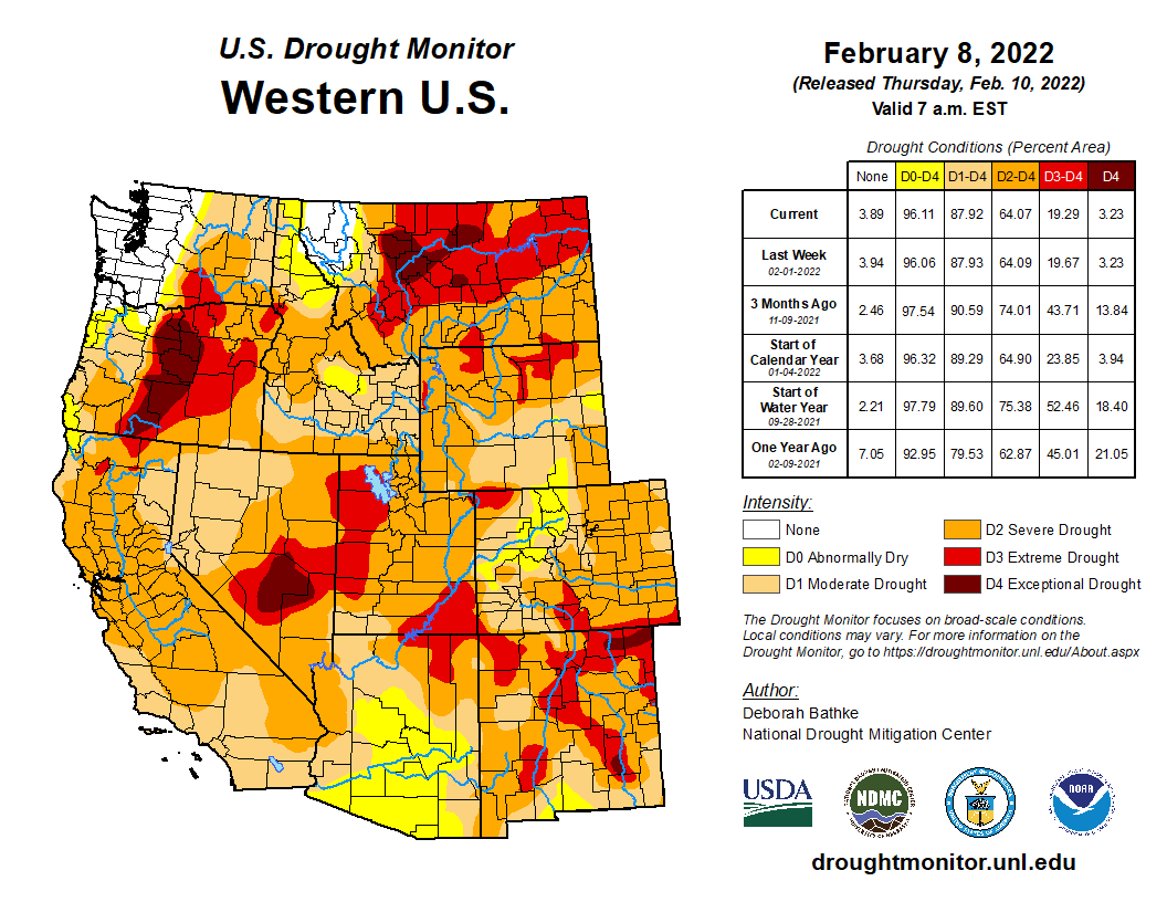
Drought conditions remain in place over 94% Colorado, Utah and Wyoming. Despite a dry last three weeks of January, drought conditions improved in parts of the region. Along the mainstem of the Colorado River in western Colorado and in central Utah, there was a one category improvement in drought conditions. Regionally, the area of extreme (D3) drought decreased, but still covers 18% of the region, including 32% of Utah.
West Drought Monitor map February 8, 2022.
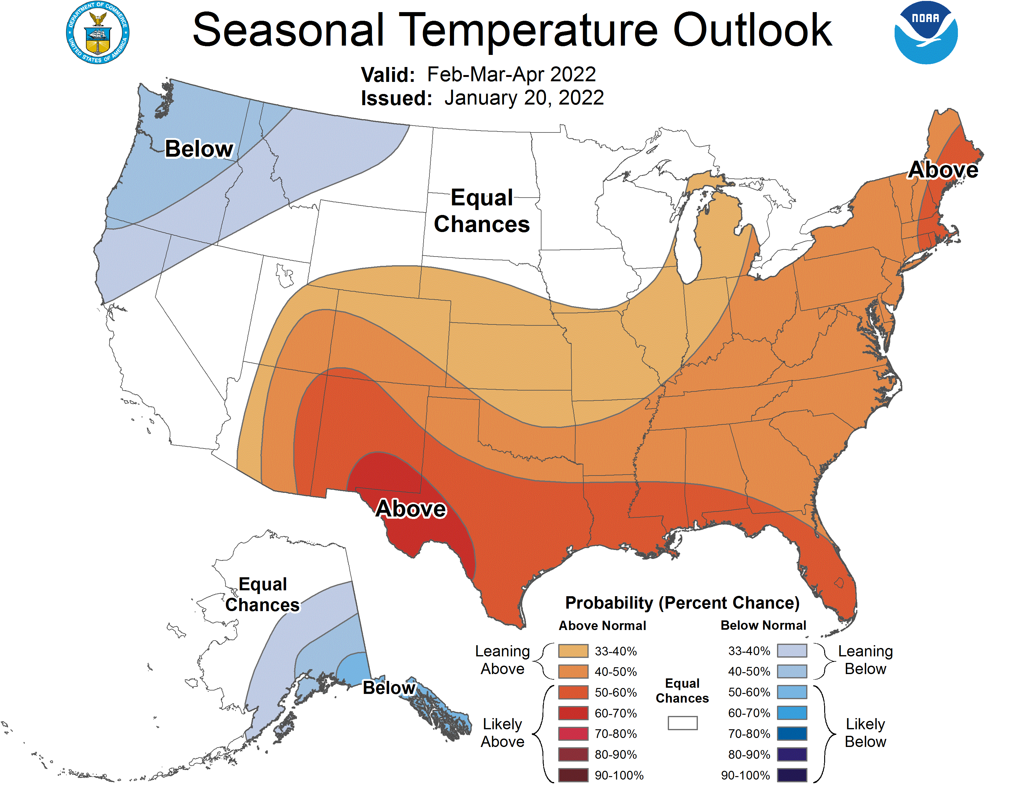
La Niña conditions remain in place over the eastern Pacific Ocean with ocean temperatures running 0.5-1º C below normal. La Niña conditions are expected to continue through April-May. A typical La Niña weather pattern, with wetter and cooler weather in the Northwest and warmer and drier weather in the Southwest, is forecasted to dominate the western United States through April. NOAA seasonal forecasts for February-April forecast an increased probability of above average temperature and below average precipitation for much of Colorado and Utah.
Significant January weather event.
Severe or prolonged storm cycles and periods of drought have characterized the 2022 water year. After a very wet and snowy October left most regional river basins with much above average snowpack, few storms impacted the Intermountain West during November and most of December. Beginning on December 23rd, a series of atmospheric river events impacted the region bringing significant snowfall to nearly the entire region until January 7th. Regional snowpack was much-above normal in early January. Over a 16-day period from December 23rd to January 7th, regional snowpack increased dramatically. In Utah, statewide snow water equivalent (SWE) went from 69% to 141% of normal. In Colorado, SWE increased from 67% to 131% of normal and Wyoming SWE increased from 73% to 118% of normal. Dry conditions returned to most of the region during the remainder of January except for southeastern Wyoming and east of the Continental Divide in Colorado. As of February 1st, statewide SWE as a percent of normal fell to near-normal conditions in Utah (97%), Colorado (107%) and Wyoming (93%). Dry conditions remained in place over the first week of February and are forecasted to remain dry until at least the middle of the month. Without significant snowfall during the last half of February, regional snowpack and streamflow forecasts will continue to decline relative to normal.
The U.S. Army announces the release of its first Climate Strategy that guides decision making in response to threats from climate that affect installation and unit sustainability, readiness, and resilience. The strategy directs how the Army will maintain its strategic advantage through deliberate efforts to reduce future climate impacts and risks to readiness and national security.
Experts have shown that climate change increases worldwide drought and insecurity, which places demands on fragile states and contributes to food scarcity, migration, and security concerns, and threatens U.S. national security interests and defense objectives. As a guide for future decisions, this strategy is the next step in the Army’s decades-long effort to combat climate change in support of national security interests.
“The time to address climate change is now. The effects of climate change have taken a toll on supply chains, damaged our infrastructure, and increased risks to Army Soldiers and families due to natural disasters and extreme weather,” said Secretary of the Army, Christine Wormuth. “The Army must adapt across our entire enterprise and purposefully pursue greenhouse gas mitigation strategies to reduce climate risks. If we do not take action now, across our installations, acquisition and logistics, and training, our options to mitigate these risks will become more constrained with each passing year.”
The Army developed its Climate Strategy as a roadmap of actions that will enhance unit and installation readiness and resilience in the face of climate-related threats. Changing climate conditions requires the Army to meet new operational challenges, expand disaster response missions, and address risks to our people and lands.
These Army-wide efforts include enhancing resilience and sustainability on our installations, reducing sustainment demand, and preparing a climate-ready force with the appropriate knowledge, skills, concepts, and plans necessary to operate in a climate-altered world.
The Army will remain the dominant land fighting force by adapting to changing global conditions including climate change. This strategy will position our installations and supply chains to better withstand extreme weather, improve our training relevancy to a changing world, and our Soldiers will fulfill their missions under the harshest conditions.
Click on a thumbnail graphic to view a gallery of drought data from the US Drought monitor.
US Drought Monitor map February 8, 2022.
High Plains Drought Monitor map February 8, 2022.
West Drought Monitor map February 8, 2022.
Colorado Drought Monitor map February 8, 2022.
Click here to go to the US Drought Monitor website. Here’s an excerpt:
This Week’s Drought Summary
A powerful winter storm last week, stretching from New Mexico to Maine, helped improve drought conditions in 17 states in its path. Meanwhile, another week of dry weather in the West put a halt to drought recovery. Parts of Montana, Wyoming, Utah, and Oregon saw drought expand as the recent dryness on top of long-term drought chipped away at snowpack and lowered streamflow. A wet December left most other parts at near normal for the season, but concerns are growing as dry weather remains in the forecast…
Last week’s snow brought widespread improvements to eastern Colorado including areas of severe (D3) and extreme drought (D3). The recent event, combined with above average January snowfall, has left a large swath of snow on the ground and improved soil moisture conditions. The remainder of the region saw another week of dry weather. Wyoming saw an expansion of D2 and D3 in the north and west parts of the state as recent warm, dry weather, chipped away at seasonal snowpack. Nebraska and Kansas saw a broad expansion of moderate drought (D1) and abnormal dryness (D0). Here, 30-to-90-day precipitation totals rank in the top 5 driest on record. Fires on the rise in these areas and burn bans are going to effect…
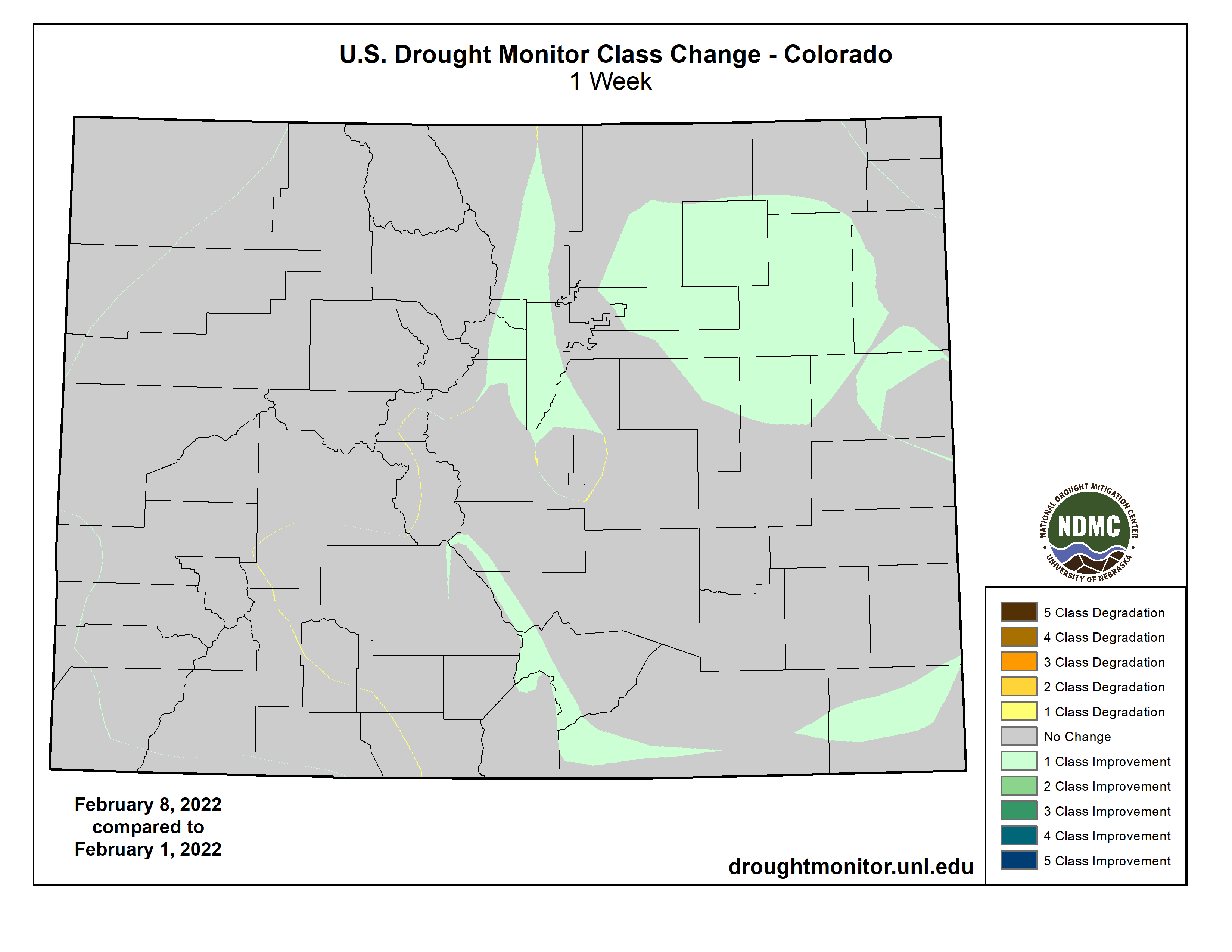
Colorado Drought Monitor one week change map ending February 2, 2022.
Weather across the West was once again dry this week. Western Oregon saw expansions to moderate (D1) and severe (D2) drought increased. Another week of dry weather increased water-year-to-date precipitation shortfalls and lowered streamflow values. The far northern Oregon Cascades saw improvement. Snowpack here is near normal for the water year. Extreme drought (D3) was expanded in Utah as increasing precipitation deficits have dried out soils and lowered streamflow. The rest of the West remains unchanged. Several weeks of dry weather has caused high elevation snowpack in parts of the west to drift away from the above-normal values at the start of the new year…
Much needed rain brought by last week’s winter storm improved drought conditions in parts of all six states in the region. Precipitation totals of around 1 to 4 inches – more than 300% of normal in some areas – fell across much of the region helping to reduce short-term rainfall deficits and improve streamflow and soil moisture conditions. Texas saw a wide band of 1-category, with isolated 2-category, improvements. In parts of South and West Texas, the excess moisture was enough to chip away at the long-term drought. Other areas seeing improvements include eastern Kansas, eastern Oklahoma, southeastern Louisiana, and southern Mississippi. Widespread drought remains in the region. Despite last week’s weather, parts of Texas and Louisiana saw expansions of drought. These areas missed out on the heaviest rain, increasing moisture deficits. In South Texas rainfall deficits are approaching 5 to 6 inches (less than 50% of normal) over the last 3 months. In southwest Louisiana, they are about 7 to 10 inches (less than 50 % of normal) over the same time frame, reducing streamflow and drying soils…
Looking Ahead
The National Weather Service Weather Prediction Center forecast (valid February 10 – 15) calls for relatively dry weather over much of the Lower 48. A pair of storms systems are expected to bring snow to the Upper Midwest and Northeast. Much of the continental U.S. will see above normal temperatures through the weekend. Moving into next week, the Climate Prediction Center (Valid February 15 – 19) Outlooks favor above normal precipitation from the Desert Southwest northeast to the Canadian border. Drier weather is favored for the northern Plains and much of the west. Temperatures are expected to be warmer than normal in the West Coast states, the central and northern Great Plains, and across much of the Lower Midwest and Southeast.
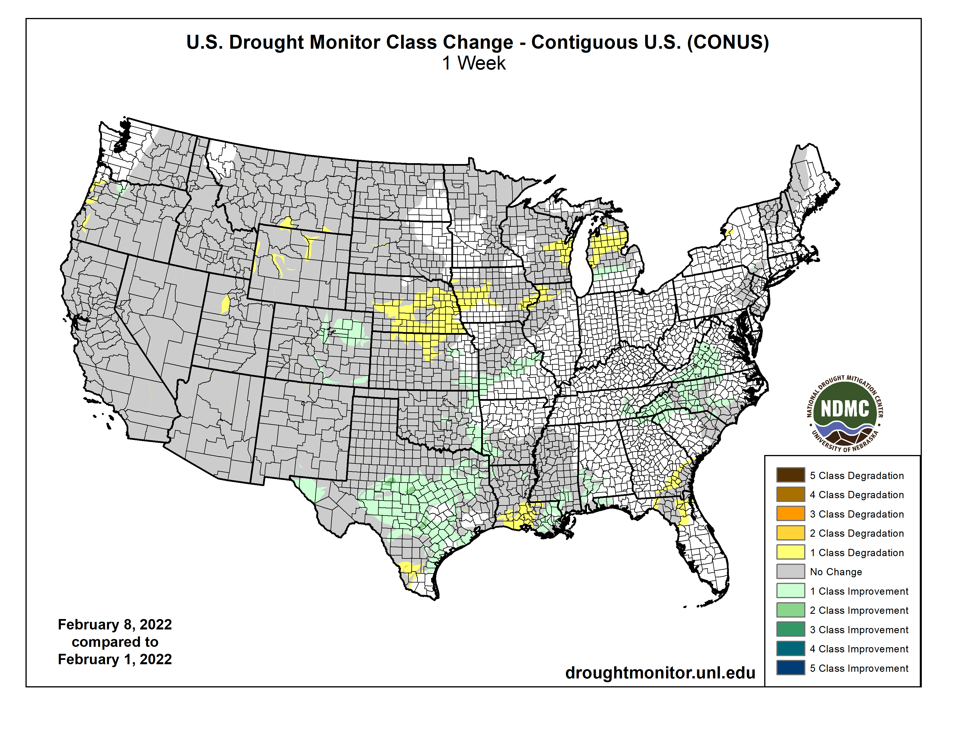
US Drought Monitor one week change map ending February 8, 2022.
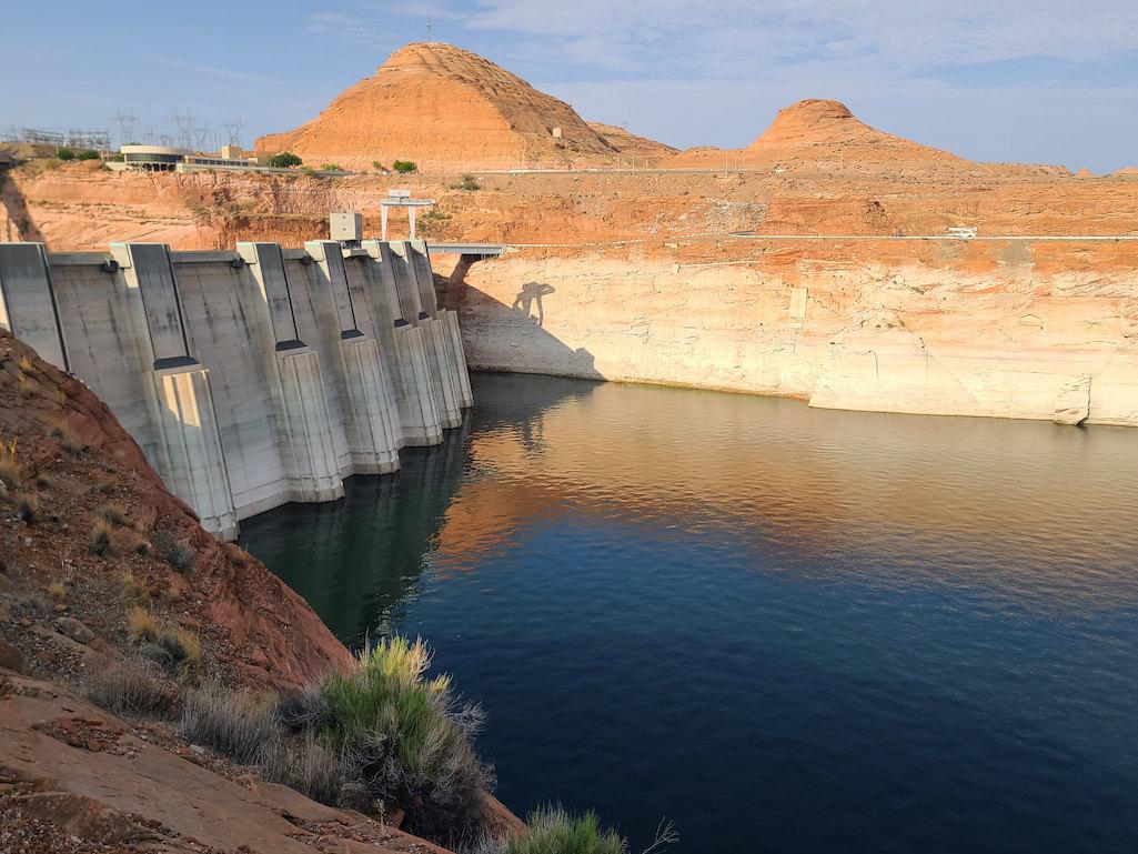
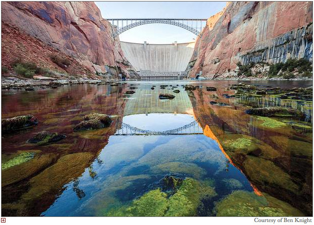
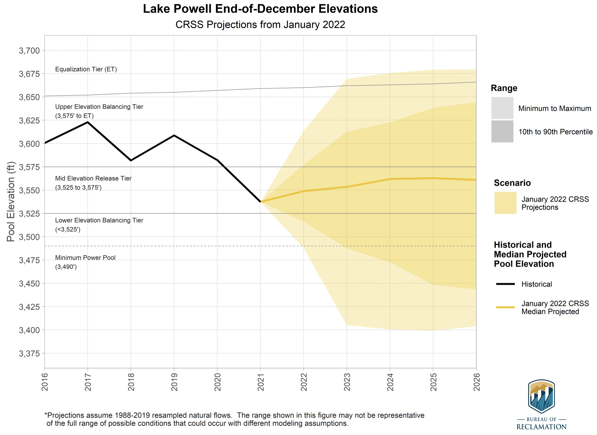
Glen Canyon Dam August 2021. The white on the sandstone reflects where the water level once was. Dropping levels at Lake Powell are forcing a reduction in outflows from the Glen Canyon Dam. Photo credit: USBR
As the crisis on the Colorado River continues, the U.S. Bureau of Reclamation and the four Upper Basin states—Colorado, New Mexico, Utah and Wyoming—have drawn up a proposed framework called the Upper Basin Drought Response Operations Plan. The framework would be used by water managers to create plans each year, as necessary, to maintain Lake Powell water levels.
The effort to keep Lake Powell healthy is critical to ensuring hydropower production from its turbines is maintained and to protect the Upper Basin states from violating their legal obligation to send Colorado River water to Arizona, California and Nevada, the Lower Basin states.
Whether the new plan will be activated this year is uncertain. During a webinar about the working draft on Jan. 28, Rod Smith, an attorney with the U.S. Department of Interior, described this year’s early winter weather as a yo-yo. “December was excellent,” he said, “but January was kind of blah.”
Lake Powell’s water levels were successfully stabilized last year after a series of major emergency water releases from reservoirs in Utah and Colorado. Lower Basin states also cut water use.
Graphic credit: Chas Chamberlin
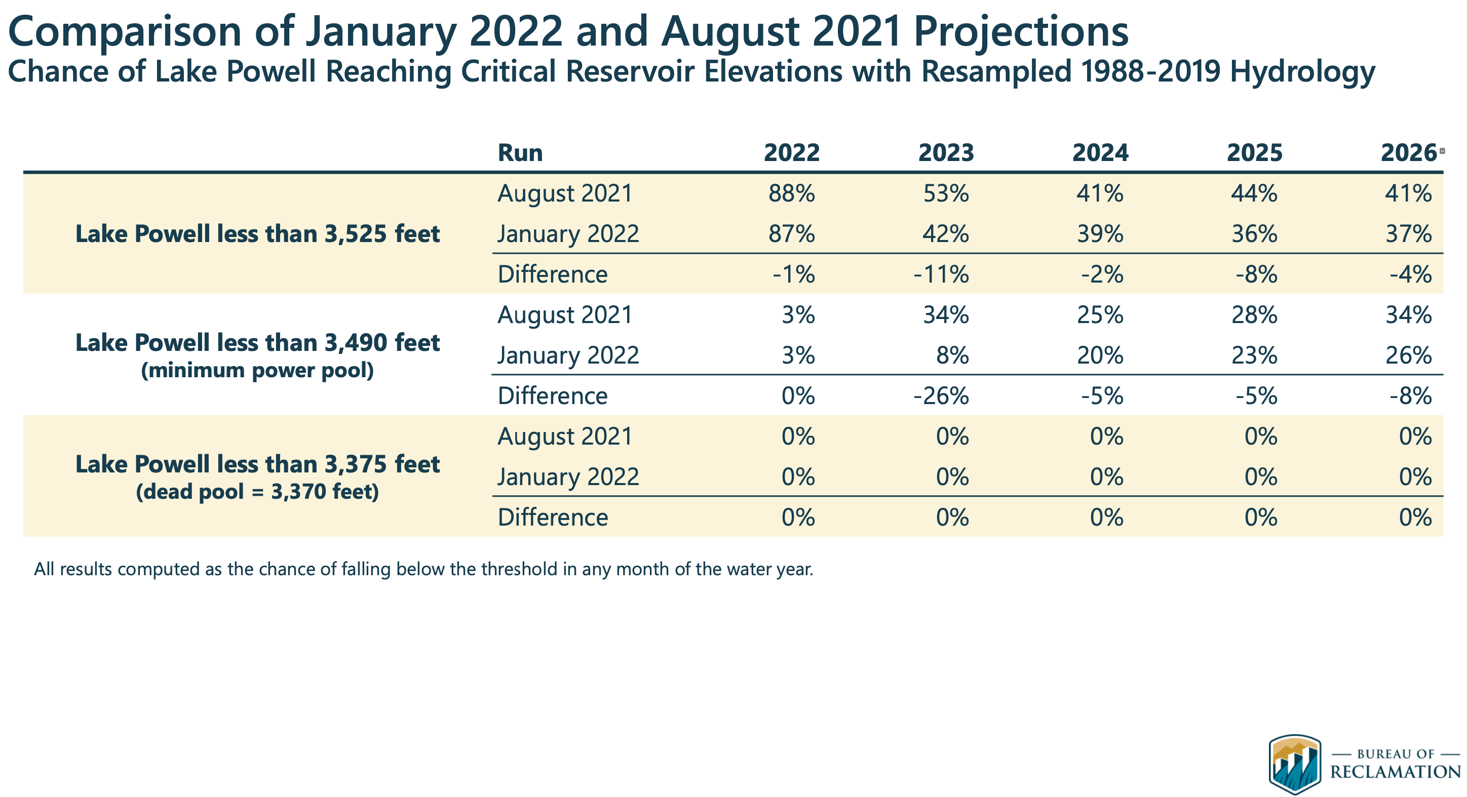
Modeling last year had found a nearly 90% probability that Powell levels in 2022 would fall below the elevation of 3,525, triggering more emergency releases. But as of Feb. 3, water levels in Powell were almost 6 feet above that elevation.
Much can change between now and April, when Reclamation and the states hope to complete the framework.
Last year’s disastrous runoff — the snowpack was roughly 85% of average but the runoff was 32% of average — surprised everyone, and ultimately forced the emergency releases from Blue Mesa and Flaming Gorge, two of three federal dams operated by the agency upstream of Powell. Reclamation also operates Navajo, the reservoir located primarily in New Mexico, whose waters can also be used to boost levels in Powell, subject to other limitations.
The proposed framework identifies how much water from the three reservoirs is available for release to prop up levels in Powell, but only after operations at Powell itself have been managed to best maintain levels of 3,525 feet or above. To slow the decline, Reclamation is holding back 350,000 acre-feet of water in Powell that it would normally release during January-April.
The agency plans this year to release 7.48 million acre-feet from Powell to flow down the Grand Canyon to Lake Mead.
Smith emphasized that the releases from Blue Mesa and other Upper Basin reservoirs will be subordinate to the many preexisting governance mechanisms on the Colorado River, including treaties, compacts, statutes, reserve rights, contracts, records of decision and so forth. “All that stays,” said Smith.
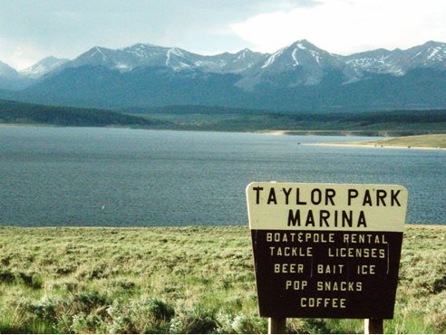
Taylor Park Reservoir
This can get complicated. For example, some water from Taylor Park Reservoir, near Crested Butte, can be stored in Blue Mesa but is really meant for farmers and other users in the Montrose-Olathe area. That water is off-limits in this planning.
Navajo Reservoir, New Mexico, back in the day.. View looking north toward marina. The Navajo Dam can be seen on the left of the image. By Timthefinn at English Wikipedia – Transferred from en.wikipedia to Commons., Public Domain, https://commons.wikimedia.org/w/index.php?curid=4040102
Navajo Reservoir releases can get even more complicated. Water was initially identified last summer for release from the reservoir to help replenish Powell, but then delayed. Reasons were identified, including temperatures of the San Juan River downstream in Utah. But feathers were ruffled, as was revealed during the Colorado River Water Users Association meeting, held in Las Vegas in December. Tribes were consulted only belatedly.
Now, the draft framework language specifies the need for consultation with tribes. Water in Navajo Reservoir is owned by both the Jicarilla Apache and Navajo. To be considered are diversions to farmers but also to Gallup. “Getting this right, particularly in the operational phase, will be critical,” said Smith.
How might this affect ditch systems in Colorado? “There will be timing issues of when the extra water comes down, but in terms of whether there are any direct impacts to a ditch authority operating under its own decree, there should not be,” said Michelle Garrison, senior water resource specialist with the Colorado Water Conservation Board, during the webinar. “We don’t expect any disruption to other water users because of this.”
[…]
“You can help make the best of a bad situation by having any drought operation releases benefit other things on the river, including benefits to threatened and endangered fish species while potentially producing more hydropower revenue [used in part to support endangered fish recovery programs],” said Bart Miller, water program manager for Western Resource Advocates.
But Miller and others also note that Reclamation’s draft framework represents a short-term solution to a festering long-term problem.
Brad Udall: Here’s the latest version of my 4-Panel plot thru Water Year (Oct-Sep) of 2021 of the Colorado River big reservoirs, natural flows, precipitation, and temperature. Data (PRISM) goes back or 1906 (or 1935 for reservoirs.) This updates previous work with @GreatLakesPeck.
The word drought is found everywhere in the planning documents. Colorado State University climate scientist Brad Udall insists that another word, aridification, better describes the hydrology that has left the Colorado River with nearly 20% less water in the 21st century as compared to the 20th century. Trying to reconcile 21st century hydrology with 20th century infrastructure and governance is like walking on a rail that gets ever more narrow.
“I think it’s totally appropriate to use this tool but not as a substitute for dealing with the overall imbalance between supply and demand,” says Anne Castle, a senior fellow at the Getches-Wilkinson Center for Natural Resources, Energy and the Environment at the University of Colorado Law School.
Long-time Colorado journalist Allen Best publishes Big Pivots, an e-magazine that covers energy and other transitions in Colorado. He can be reached at allen@bigpivots.com and allen.best@comcast.net.
Here’s the release from the NRCS (Brian Domonkos):
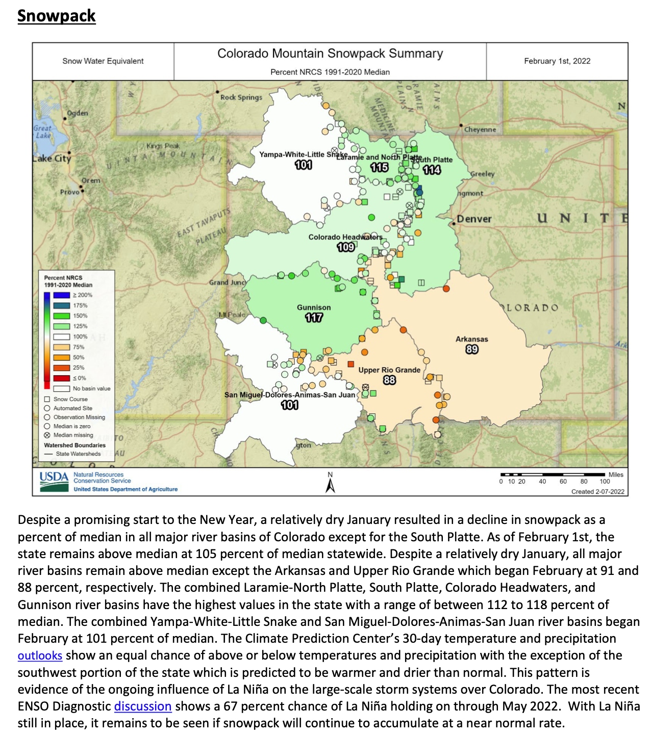
Mountain snowpack accumulations across Colorado have slowed down since the beginning of the year but conditions are generally surrounding normal across the major river basins. That said, it is important to note that percent of normal values have been updated from the 1980-2010 period to 1990-2020 so there are changes in comparison to the last decade. This change is a standard across many other water and climate monitoring networks across the country which helps with consistent reporting and comparability.
Colorado snowpack basin-filled map February 9, 2022 via the NRCS.
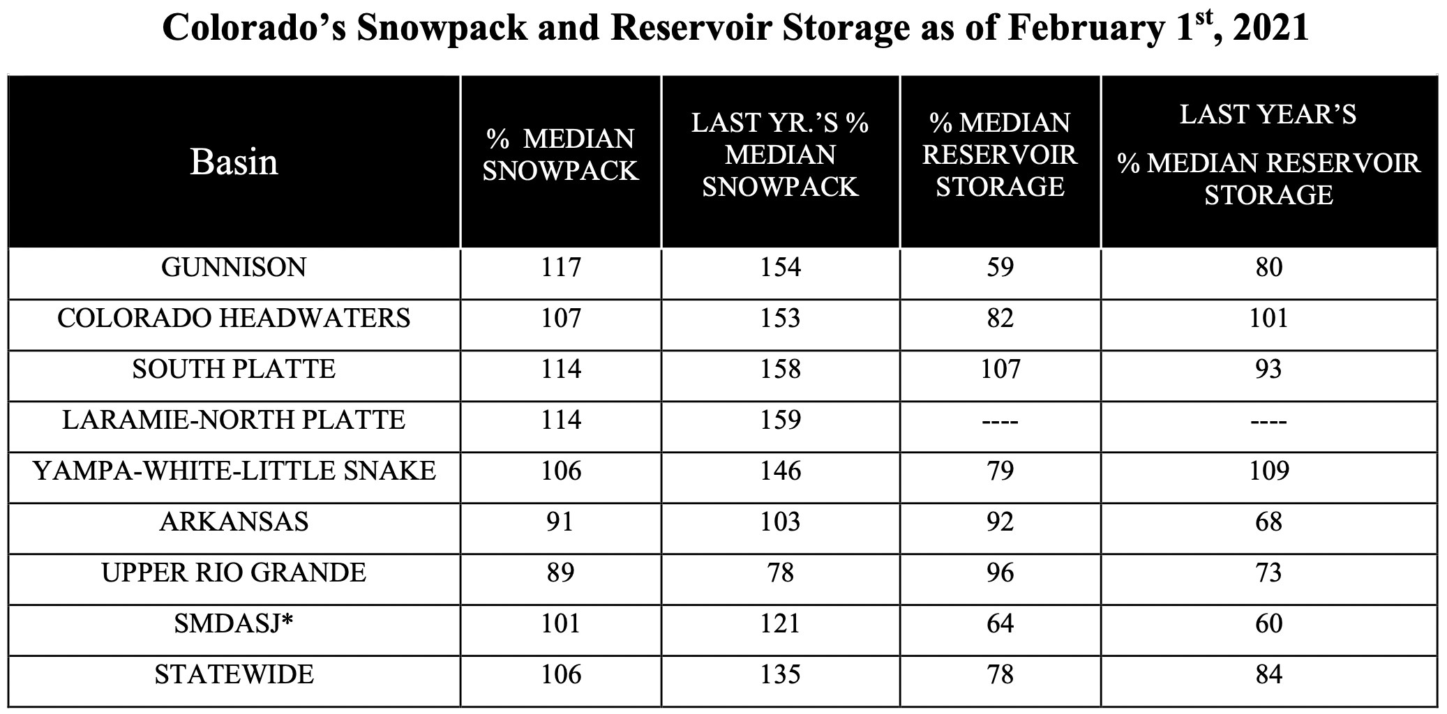
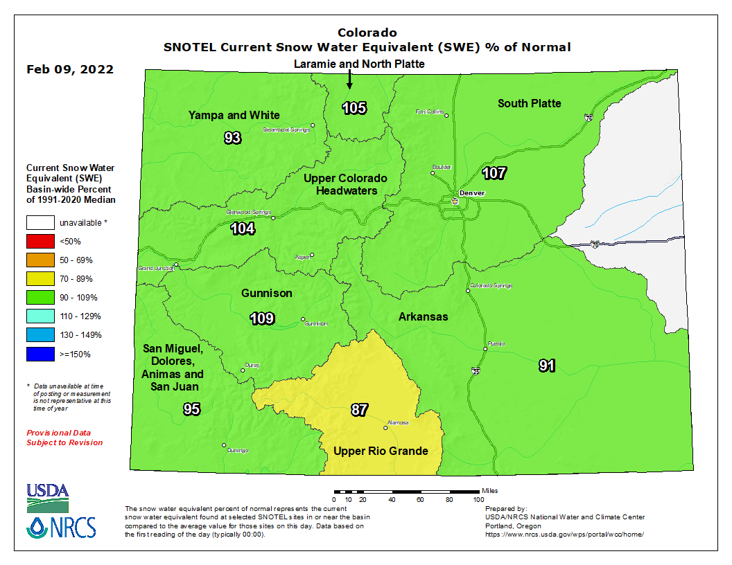
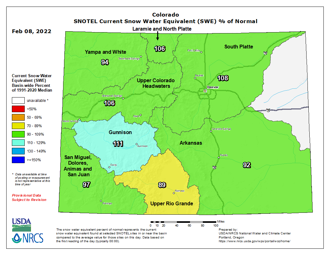
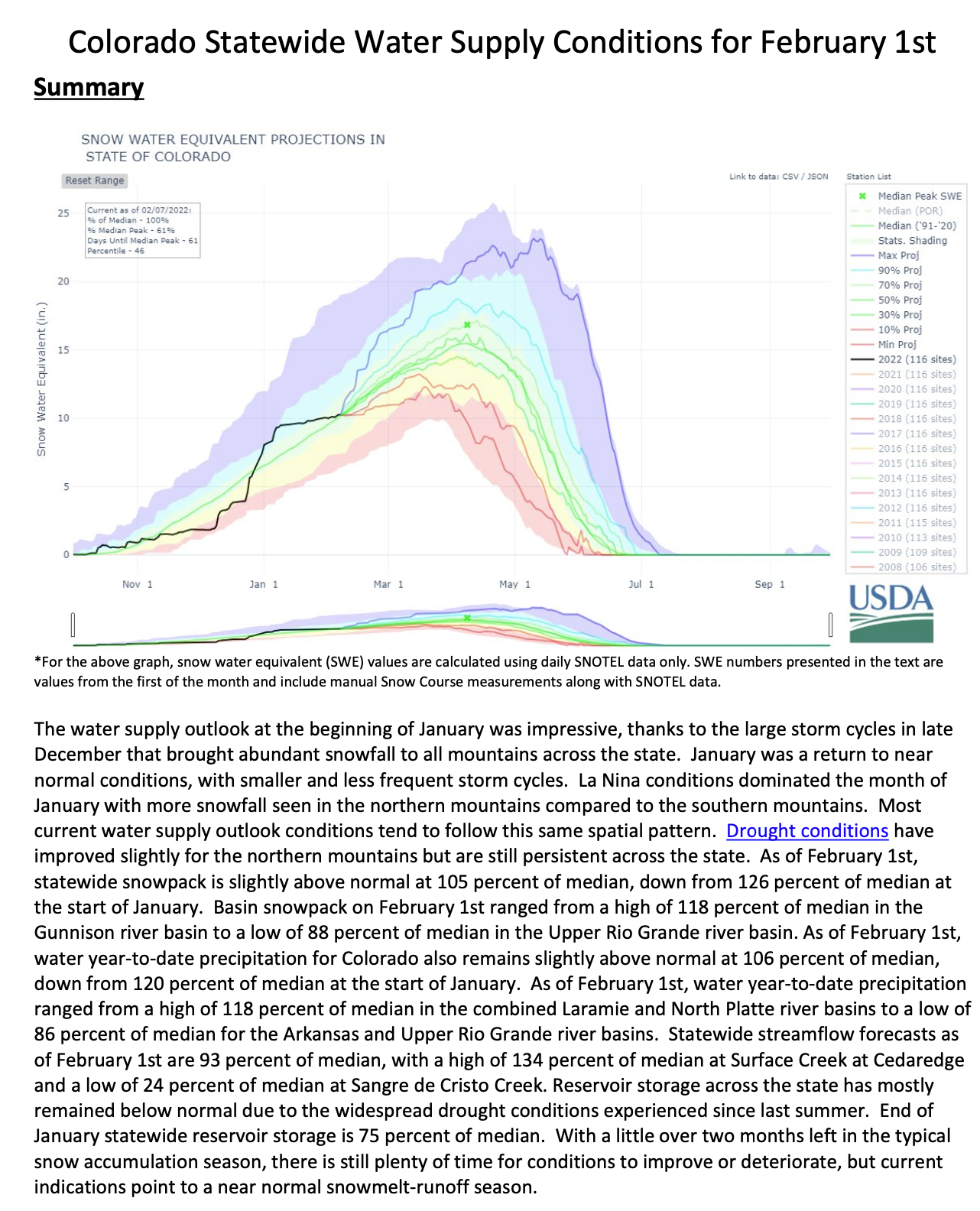
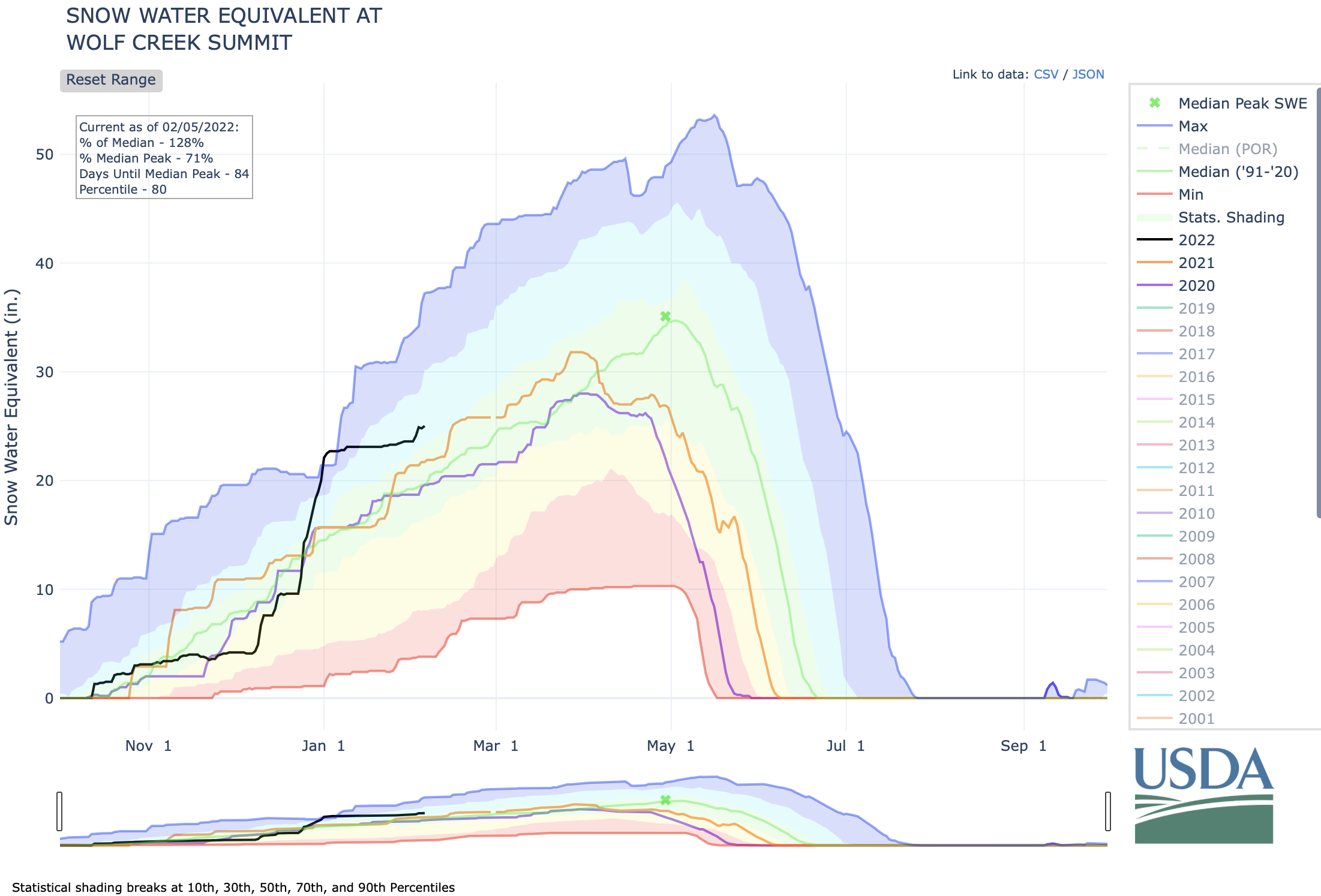
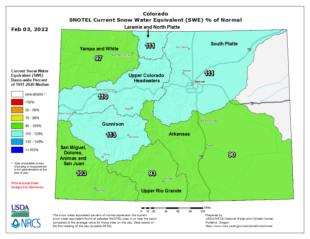
Currently Colorado statewide snowpack is 100 percent of normal (median) with some variation basin to basin but with not as much variation as has been observed over the last several years. Snowpack ranges from a low of 89 percent of normal in the Upper Rio Grande to a high of 110 percent of normal in the Gunnison River Basin. Statewide this is 60 percent of the median peak accumulation that is generally observed in early April.
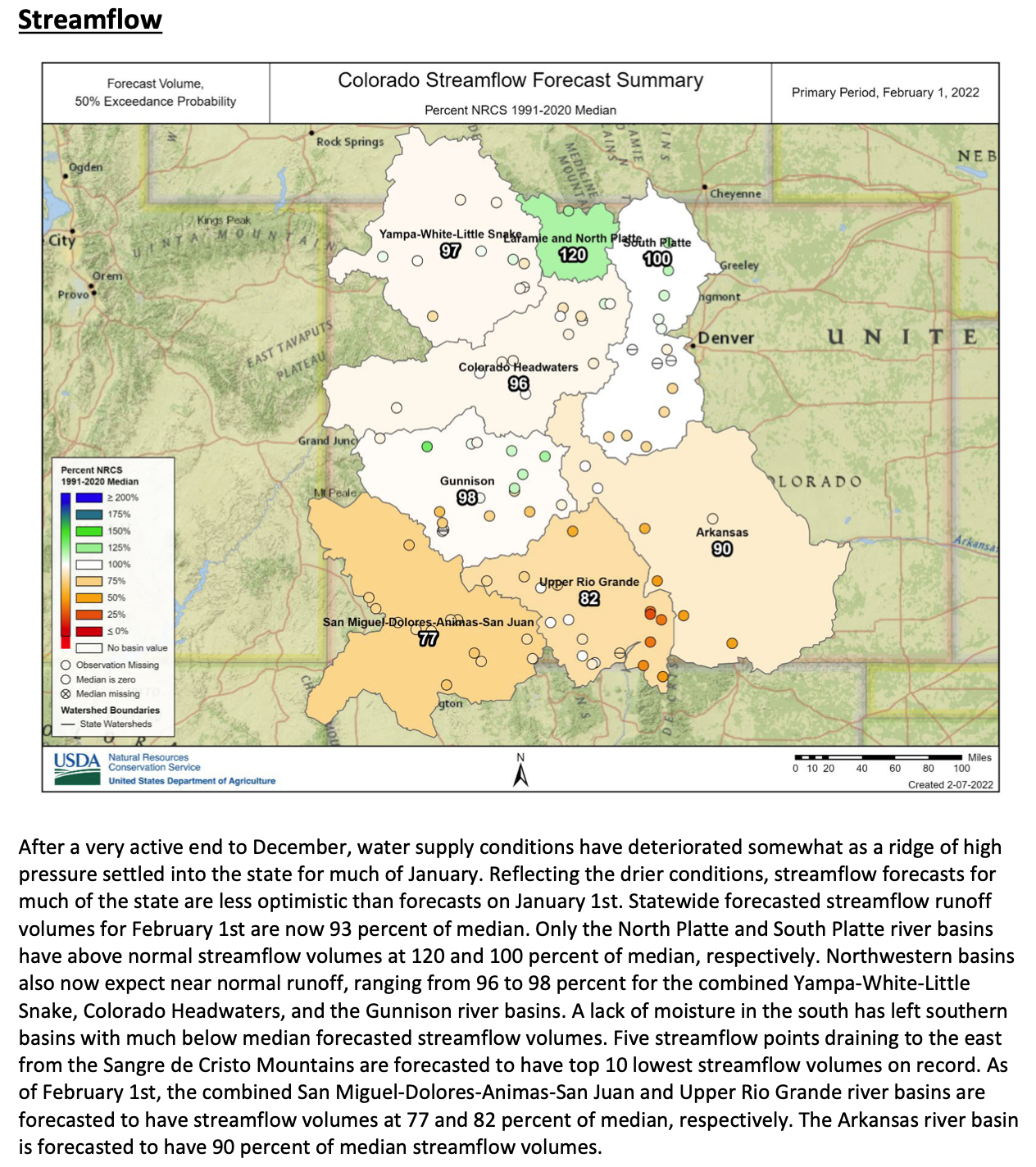
Water year to date precipitation, starting October 1st, is very similar to snowpack at 103 percent of normal. NRCS hydrologist Karl Wetlaufer notes that “While the current conditions are encouraging it is important to consider that due to the multi-year drought can effect snowmelt runoff. Dry soil conditions going into winter can reduce the observed streamflow relative to what the observed peak snowpack ends up being.”. Streamflow forecasts are currently lower than snowpack levels, as would be anticipated given the conditions going into winter.
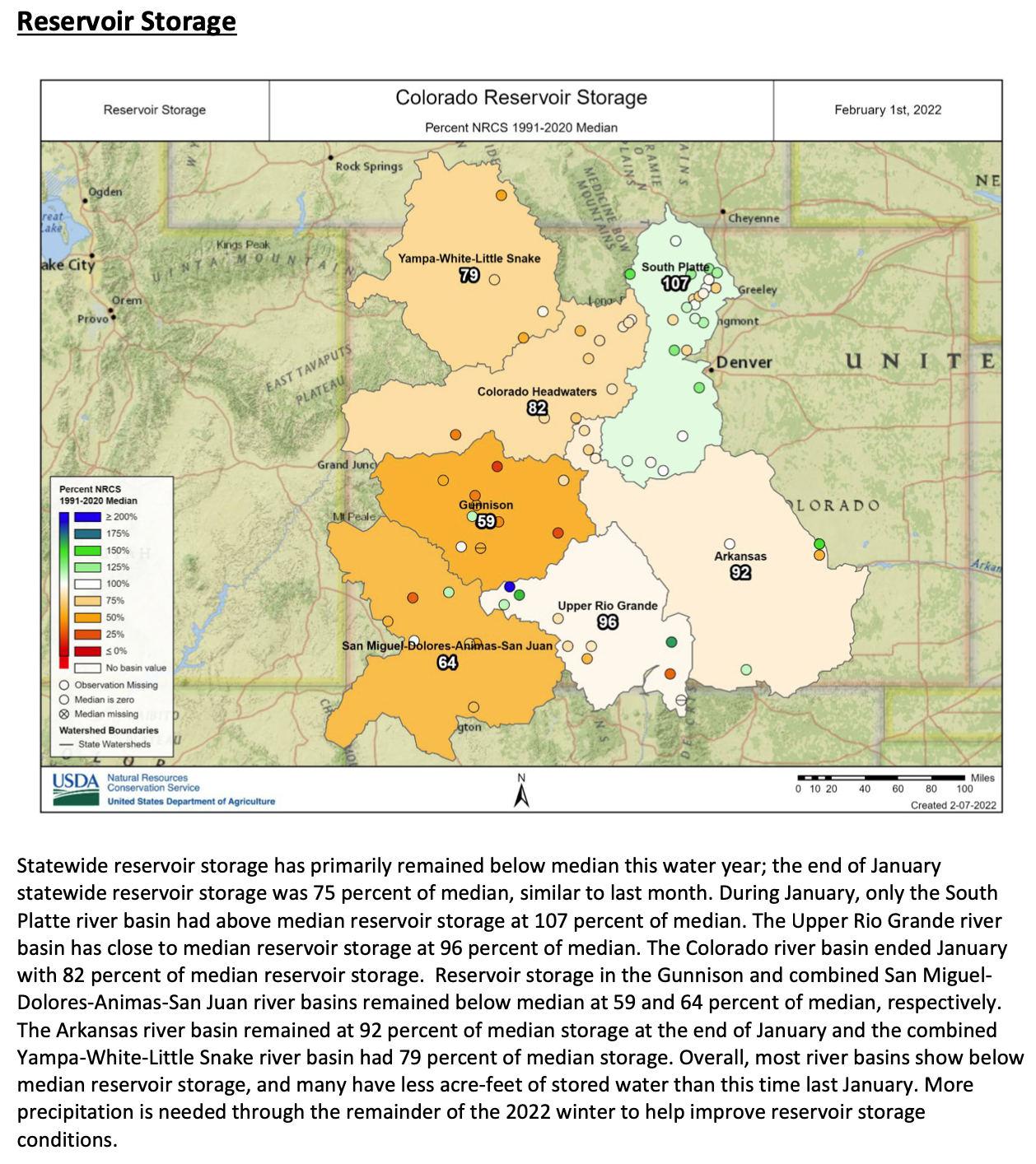
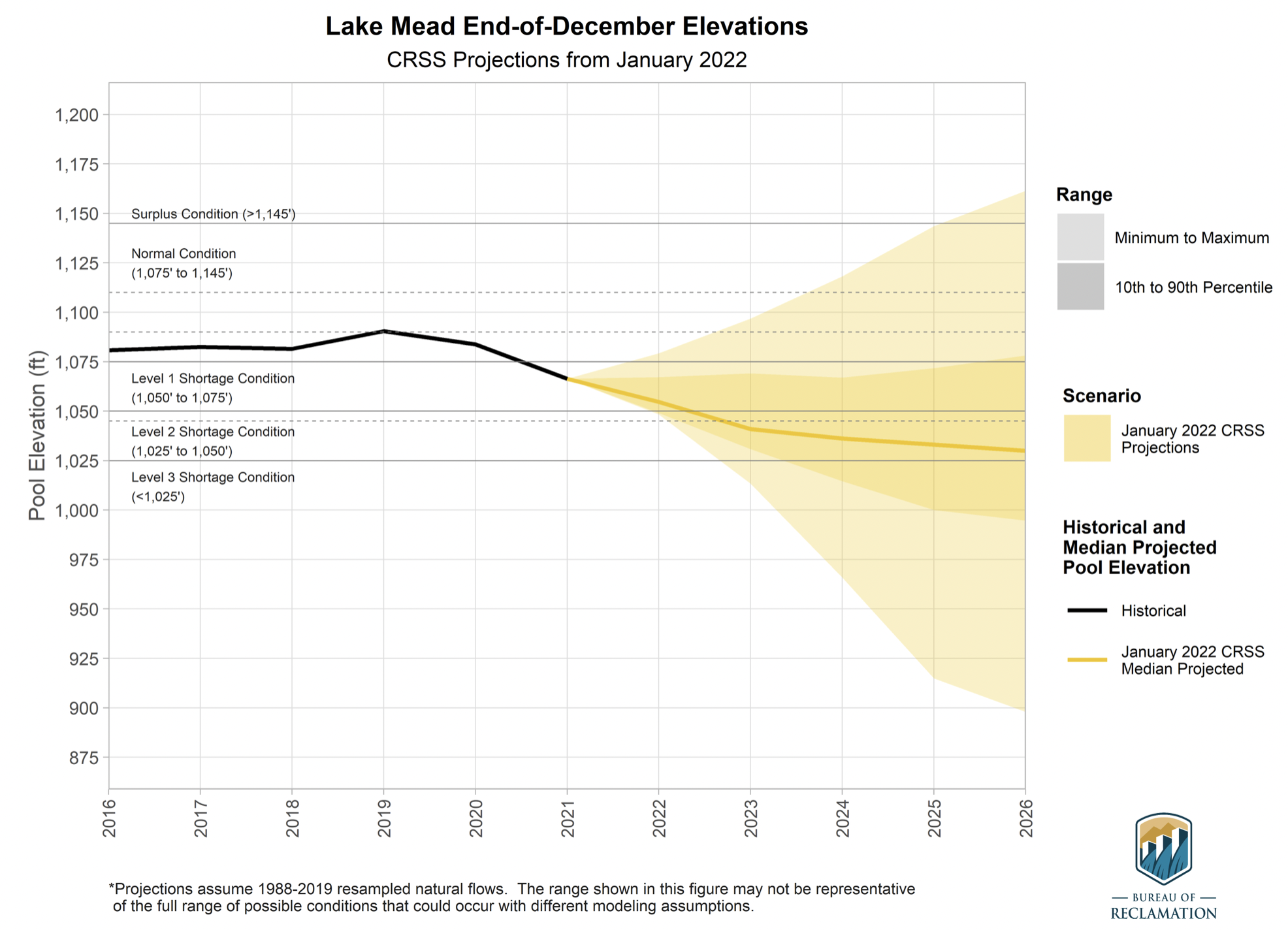
In the big picture of water supply and water availability reservoir storage is also currently a major consideration in Colorado. Southwest Colorado currently has the lowest reservoir storage in the state with 59 percent of normal in the Gunnison and 64 percent in the combined San Miguel, Dolores, Animas, and San Juan Basins. The most plentiful reservoir storage in in the South Platte at 112 percent of normal. Wetlaufer continued to note “In addition to the reservoirs within the state it should also be kept in mind that Lake Powell and Lake Mead, are also at the lowest levels on record which has an effect on the entire Colorado Basin and can continue to affect the headwaters here in Colorado.” There is still much potential snowpack accumulation season to come but changing water supply conditions should still be closely watched.
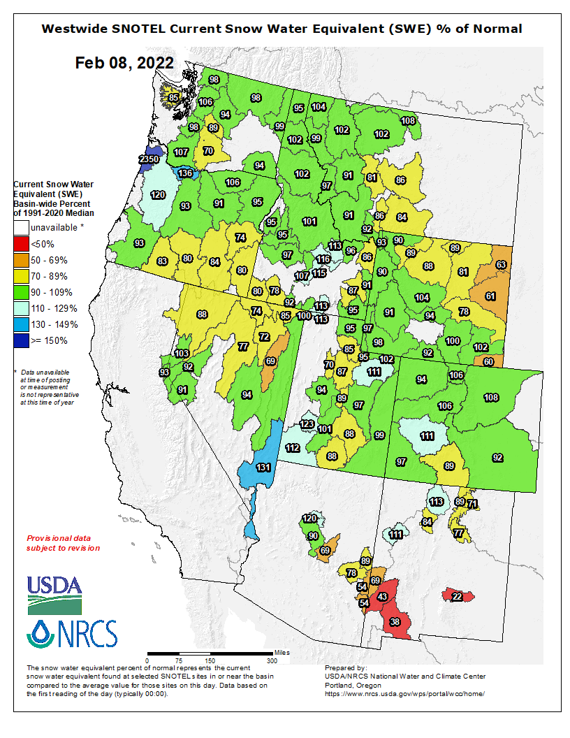
Westwide SNOTEL basin-filled map February 10, 2022 via the NRCS.
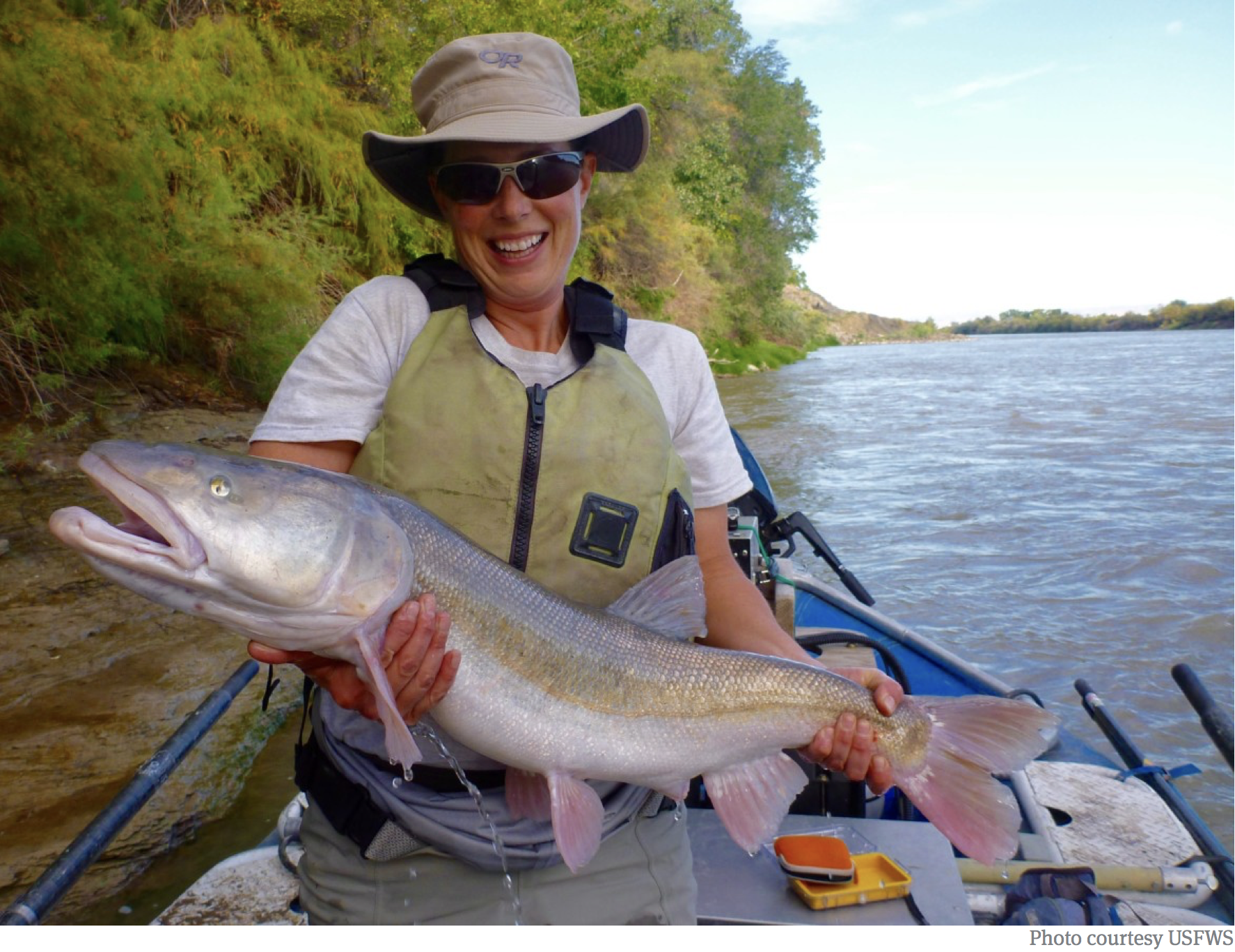
A Colorado pikeminnow taken from the Colorado River near Grand Junction, and in the arms of Danielle Tremblay, a Colorado Parks and Wildlife employee. Pikeminnows have been tracked swimming upstream for great distances to spawn in the 15-mile stretch of river between Palisade and Grand Junction. An apex predator in the Colorado, pikeminnows used to be found up to six feet long and weighing 100 pounds. Photo credit: Lori Martin, Colorado Parks and Wildlife via Aspen Journalism
Hydropower dams blocked the fish’s migrations for spawning, altered river flow and churned cooler water downstream. The Colorado pikeminnows, which were not accustomed to the cooler waters, were soon outcompeted for food by nonnative fish. Now, most Colorado pikeminnows reach only two to three feet long.
“Those fish are now endangered and have been replaced with cold-water-adapted trout,” said Gordon Holtgrieve, a fish ecologist at the University of Washington. “The river doesn’t look anything like it used to, and Native Americans of the region, who traditionally used these fish, have lost part of their culture.”
[…]
The ubiquitous dams around the world are built to guard against extreme flooding, meet steadily increasing water demands and provide hydroelectric power. They also alter river ecosystems — such as by changing temperatures downstream — and can substantially change nearby fish populations…
Worldwide, at least 3,700 medium and large hydropower dams are planned in the coming decades or under construction, heavily concentrated in South America, Africa and South and East Asia. Hundreds of millions of people in large river basins in these areas rely heavily on the river for their livelihoods, Holtgrieve said. For example, Cambodians receive about 80 percent of their animal protein from primarily wild-caught freshwater fish from the Mekong River.
Now, in a recent study, researchers have created a first-of-its-kind machine learning model that can predict temperature changes as a result of dams planned around the globe and could help planners and engineers mitigate the environmental impact. Analyzing future dams worldwide, the team found some dams changed downstream temperatures by as much as 10.8 degrees Fahrenheit (6 degrees Celsius).
Based on the research, the team created a public tool that allows people to plug in the dimensions of a future dam and learn how it will affect downstream temperatures.
The current snowpack is running at just about normal levels in the highest elevations of the Eagle River watershed. But that isn’t great news.
The snowpack readings haven’t been bolstered by significant snow in some time, and there doesn’t seem to be much relief on the horizon.
According to Lucas Boyer, a meteorologist at the Grand Junction office of the National Weather Service, a ridge of high pressure over the Pacific Ocean just off the West Coast of the United States is keeping moisture from heading toward Colorado…
Meteorologists generally don’t predict with confidence past seven to 10 days. That’s the job of the U.S. Climate Prediction Center. There isn’t much good news coming from that office. That agency’s most recent prediction for the next three to four weeks calls for “equal chances” of either above- or below-average precipitation for all but the farthest northwest corner of the state. The Climate Prediction Center is also calling for a chance of above-average temperatures for the state…
Colorado Drought Monitor February 8, 2022.
A U.S. Drought Monitor report from Feb. 1 notes that much of the Intermountain West remains in some form of drought. In Colorado, 19% of the state is in “extreme” drought. Parts of Eagle and Summit counties are listed as being in a “severe” drought…
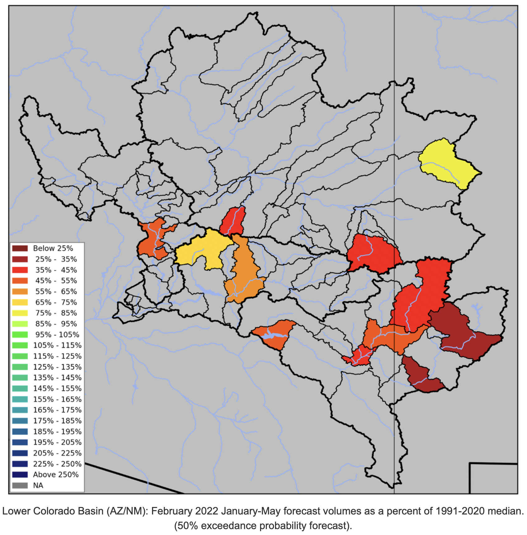
That’s bad news for streamflows during the spring and summer. A Feb. 3 report from the National Oceanographic and Atmospheric Administration indicates that the upper Colorado River will supply users with between 80% and 105% of normal supplies.
Diane Johnson, the communications and public affairs manager with the Eagle River Water & Sanitation District, said while snowpack is holding at near-normal levels, that could be due to cold temperatures — we’re in the middle of winter, after all — and the fact that the 30-year snowpack median is lower than it was five years ago.
Johnson said lower streamflows, especially given that dry soils will absorb melting snow before it hits local streams, are a continuing worry for the district.
Dry conditions are also a worry for local fire departments. Johnson said a proposal in Vail to require all buildings to have a 5-foot buffer can help. But, she added, more help could come from people changing the way they plant for outdoor landscaping.
Water sustains the San Luis Valley’s working farms and ranches and is vital to the environment, economy and livelihoods, but we face many critical issues and uncertainties for our future water supply. (Photo by Rio de la Vista.)
Here’s release from Adams State University (Linda Relyea, Rio de la Vista):
“In Scarcity, Opportunity for Community” is the theme for the Salazar Rio Grande del Norte Center hosted Rio Grande State of the Basin Symposium this year. These words, from the pen of the late Justice Greg Hobbs, are as timely as ever, as the San Luis Valley faces water scarcity from several directions. In the past, whenever we’ve faced risks, this community comes together to protect our water future. This is the opportunity ahead, if we are able to rise to it.
What is the status of our water supply, current threats and opportunities? We’ll provide updates, information and future forecasts for 2022 at the fourth annual “Rio Grande State of the Basin Symposium.” It will be held virtually, Saturday, February 26th, from 9 am to 1 pm. Co-hosted by the Salazar Rio Grande del Norte Center at Adams State University and the Rio Grande Water Conservation District, the event is free and open to the public. The Symposium is also a featured program of the Adams100 series, celebrating the first 100 years of Adams State University. Register on-line here to receive a Zoom link to the event.
Keynote Speaker for the 2022 Rio Grande State of the Basin Symposium: Dr. Maria E. Montoya. Photo credit: Adams State University
Dr. Maria E. Montoya to be Keynote Speaker
“We’re looking forward to hearing a new voice and a global perspective on water scarcity and communities from our keynote speaker this year, historian Dr. Maria E. Montoya in her presentation, ‘A Look at Water Scarcity Globally: From the American West to China’,” said Salazar Center Director Rio de la Vista. With family roots in the San Luis Valley and the southwest, Maria E. Montoya is a Global Network Associate Professor of History at New York University and the Dean of Arts and Sciences at NYU Shanghai. She earned her BA, MA and PhD degrees at Yale University. Her research explores how workers and families in the nineteenth and early twentieth centuries have used natural resources to make a living and make their homes in particular places in the American West, with numerous books and articles published on these topics. Dr. Montoya is currently working on another book project about the scarcity of water in the American Southwest and the Rio Grande.
Symposium Agenda Overview
“We’re very pleased to have long time Adams State business professor and newly appointed State Director for the USDA’s Colorado Office of Rural Affairs, Armando Valdez as our Master of Ceremonies,” said de la Vista, “As a multigenerational farmer/rancher from the Capulin area, a water leader, educator and now statewide leader, he brings his valuable perspective to the whole event.”
The morning will begin with a report on the current “State of the Basin,” including the latest data on snowpack measurements and flow forecasts by Division Engineer, Craig Cotten with the Colorado Division of Water Resources. He will also provide information about the state of our groundwater and related challenges. Given the various aspects of community and water scarcity facing our community now and in the time ahead, the Symposium agenda will address three key causes of water scarcity and the community’s response to them: the state of the Valley’s aquifers and subdistricts, the current threat of water exportation, and the changes being experienced due to climate change.
The session on “What’s up with the aquifers?” will include a panel addressing the status of the aquifers and the work of the Groundwater Management Subdistricts to achieve ground water sustainability. Amber Pacheco from the Rio Grande Water Conservation District, George Whitten, rancher and water leader in Saguache County, and Charlie Goodson of Colorado Open Lands will answer questions on these issues.
For the session on “What’s up with the water exportation threat?”, Heather Dutton, Manager of the San Luis Valley Water Conservancy District will give an update on the latest developments with the proposal to move SLV water to Douglas County. Michael Carson of the Rio Grande Water Conservation District will let participants know how they can learn and engage in the collective effort to prevent exportation and the collaborative protectsanluisvalley.com information source.
“What’s happening with climate change?” will be addressed by well known journalist and author Laura Paskus, drawing from here recent book, “At the Precipice: New Mexico’s Changing Climate,” which was published in September 2020 by the University of New Mexico Press. Based in Albuquerque, New Mexico, Paskus is the environment reporter for New Mexico PBS, and produces the monthly series, “Our Land: New Mexico’s Environmental Past, Present and Future.”
The program will also include information about the Rio Grande Basin Roundtable’s newly completed Rio Grande Basin Implementation Plan from Emma Reesor of the Rio Grande Headwaters Restoration Project. Becky Mitchell, Director of the Colorado Water Conservation Board will update on the new version overall Colorado Water Plan. State Senator Cleave Simpson will share the latest on water bills at the Colorado State Legislature. The program will also provide information about the Salazar Rio Grande del Norte Center’s upcoming water education programs for Adams State and the community.
Hosts and Sponsors
The Salazar Center and the Rio Grande Water Conservation District are co-hosts of the annual Rio Grande State of the Basin Symposium, with generous support from the Colorado Water Conservation Board. Symposium sponsorships from the SLV Chapter of Trout Unlimited, the Conejos Water Conservancy District, the SLV Irrigation District, the SLV Water Conservancy District, Colorado Open Lands, Headwaters Alliance and generous individual donors all help make this event possible and free to the community.
To register and for more information about the 2022 Rio Grande State of the Basin Symposium, click here. Interested citizens can also follow the Salazar Rio Grande del Norte Center on Facebook for regular updates on water issues and get information about Water Education program at Adams State University at http://www.adams.edu/about/salazar-center/ or contact them directly at salazarriograndecenter@adams.edu.
To learn even more about water issues in the Rio Grande, videos of previous year’s presentations from the 2019, 2020, and 2021 Rio Grande State of the Basin Symposiums and other past water talks are all available online at: https://www.youtube.com/playlist?list=PLM1XIDdQr4T5uncIUerKvQUhESIzAcfoO. The 2022 Symposium recordings will be posted there as well, as part of the Salazar Center’s on-going work to develop a Rio Grande Library of water information and resources.
San Luis People’s Ditch March 17, 2018. Photo credit: Greg Hobbs
The recent cycle of snow we endured brought Denver back to a reasonable spot in terms of seasonal snow accumulation which is good news considering how the season started. The thing is, the recent storm cycle largely missed much of the high country, leaving them with mediocre snow totals over the past couple of weeks. January began in the mountains with above-average snowpack numbers, and thank goodness for that because due to the lack of snow, snowpack numbers are much lower than where they were a month ago…
By early January, some snow finally started to cover the Eastern Plains while at this point, the mountains were in the midst of getting hammered by several big snowstorms. Many mountain locations gained 3 to 8 feet of snow during the storm cycle over the holidays…
Between early January and early February, Denver (downtown) picked up quite a bit of snow leaving the area close to the average for the date in terms of seasonal snow. More on that below.
Overall, this season has been one of ebbs and flows. There have been periods of heavy snow region-wide, but there have also been bouts of dry and warm weather. When condensing all of this together, we can get an idea of where we stand compared to average…
Snowpack across Colorado is overall good, but these numbers are down a good bit from where they were a month ago when snowpack statewide was nearing 130% of normal. While we’ve lost a good deal of snow with the mild and dry weather in the mountains, the big storms we saw around the holidays gave us a great cushion. However, that cushion has been almost completely eradicated, so it’s about time for us to get some snow back up there.
The active weather we’ve had along the Front Range possibly gave the impression that the mountains were getting just as much snow but that was not the case. Most mountain locations saw near no snow over the last few weeks.
Westwide SNOTEL basin-filled map February 8, 2022 via the NRCS.
Click this link to read the report from the USGS. Here’s the abstract:
Climate change presents new and ongoing challenges to natural resource management. To confront these challenges effectively, managers need to develop proactive adaptation strategies to prepare for and deal with the effects of climate change. We engaged managers and biologists from several midwestern U.S. Fish and Wildlife Service field stations to understand recent and future climate change effects, identify adaptation barriers and opportunities, and pilot an approach for integrating adaptation thinking into management planning. To start, three structured discussions informed our understanding of how managers currently deal with climate change effects, the strategies being implemented to cope, and the barriers that limit climate change adaptation efforts. We used these insights to develop a multiday virtual workshop geared toward identifying potential adaptation strategies for managed wetlands. First, we developed a conceptual model to visualize how management actions are used to meet habitat objectives within wetland management systems. Next, we discussed how climate change may affect management actions and objectives; we used this understanding of potential effects to spatially assess vulnerability of managed wetlands to climate change. Using a scenario planning approach, we incorporated multiple potential future conditions and identified effects and adaptation strategies that could be considered for each scenario. As a result, several adaptation strategies for managed wetlands under dry and wet future scenarios were identified that can be applied when developing site-specific adaptation plans. Based on our piloted approach, we determined it would be important to have an adaptation team composed of scientists and manag- ers to facilitate discussions, develop appropriate scenarios, and identify realistic adaptation options. We document the tools, findings, and adaptation thinking process taken to enhance adaptation efforts of managed wetlands. The adaptation think- ing process can be applied to advance adaptation efforts in other habitats, ecosystems, and site-specific land management.
The National Weather Service (NWS) is an agency of the United States federal government that is tasked with providing weather forecasts, warnings of hazardous weather, and other weather-related products to organizations and the public for the purposes of protection, safety, and general information. It is a part of the National Oceanic and Atmospheric Administration (NOAA) branch of the Department of Commerce, and is headquartered in Silver Spring, Maryland, within the Washington metropolitan area. The agency was known as the United States Weather Bureau from 1890 until it adopted its current name in 1970.
The NWS performs its primary task through a collection of national and regional centers, and 122 local Weather Forecast Offices (WFOs). As the NWS is an agency of the U.S. federal government, most of its products are in the public domain and available free of charge.
…Tinniswood and his team stumbled upon something even more surprising, and somewhat encouraging: roughly five acres of pristine greenery amid an otherwise burned-out area along Dixon Creek, a tributary in the Sprague River watershed. At the center were roughly eight active beaver dams. But this was more than a refuge from fire, which hundreds of beaver dams are known to have afforded to other riparian areas. Whereas fish seemed to have disappeared upstream of the Dixon Creek dam site, the downstream water was crystal clear—and trout were thriving as though the fire had never happened. The dams and ponds appeared to have altered the hydrology of the landscape around them, Tinniswood says. The beavers had effectively built something like a water treatment plant that staved off fire-related contamination.
Similar dam-driven refuges have been documented from Colorado to California, Idaho to Wyoming. Now, scientists are discovering that these green sanctuaries are part of a larger story of how beaver dams contribute to fire resilience. Along with deterring the flames themselves, beaver dams and ponds also function as filters for ash and other fire-produced pollutants that enter waterways—thus maintaining water quality for fish, other aquatic animals, and humans—emerging evidence suggests.
Tinniswood isn’t the first to observe that beaver dams protect streams from the toxic effects of postfire runoff. In the past several years, as climate change has ramped up wildfire frequency and intensity throughout the western U.S., similar accounts have come in after fires across the region. These range from the 2018 Sharps Fire in Idaho to the 2020 Lefthand Canyon and Cameron Peak fires in Colorado. Ecohydrologist Emily Fairfax of California State University Channel Islands, who personally made such observations in Colorado, says such findings support efforts to conserve and reintroduce beavers in the West, and to establish human-made structures that mimic beaver dams—a growing movement in riparian restoration…
The filtration provided by dams is crucial for the surrounding ecosystem. In the aftermath of wildfires, autumn rain and spring snowmelt wash sediment into waterways—including ash and other debris, and soil that vegetation normally would hold in place. This pulse of pollution can be deadlier to aquatic life than the fire itself, Tinniswood said. Just as humans struggle to breathe air that’s thick with smoke, fish can’t take in enough oxygen from water laden with sediment that their gills are not designed to block…
Beaver dams and ponds filter out sediment by slowing the rate at which water flows, says researcher Sarah Koenigsberg at the Beaver Coalition, an Oregon-based nonprofit organization that promotes conservation. When water lazily drifts through a beaver pond rather than rushing in a torrent down a narrow channel, suspended sediment has time to settle on the bottom where it poses less risk to fish and other aquatic animals. “You can almost think of it like a coffee filter,” Koenigsberg said.
One of the coldest spots in Colorado and, indeed at times, the country: Antero Reservoir, on the high South Park plain, near Fairplay. Photo credit: Denver Water
Though Antero Reservoir might not hold the record for coldest temperature ever recorded in Colorado, it is known for a unique microclimate in the area that frequently results in the frigid temperatures.
Here’s a look into what’s at play:
Antero Reservoir is located in a high-elevation basin called South Park, which is a large valley at about 9,000 feet above sea level that’s surrounded by mountains on all sides, stretching for about 1,000 square miles. As a result, cold and heavy air slides down the sides of the surrounding mountains and into the open, flatter space below. This is a natural phenomenon known as ‘cold air draining.’
The ‘cold air draining’ isn’t the only way the unique geographic features around Antero Reservoir help keep the valley cold. Because Antero Reservoir is in the middle of a large and mostly flat plains area and is farther from the mountains that surround the South Park valley, air tends to stay relatively calm there. This lack of wind is something that can prevent warm air from being mixed in with cold air, with air likely to be more tumultuous when in close proximity to a slope.
Another factor in the cold temperatures that frequent Antero Reservoir and the greater South Park basin is something called ‘radiational cooling.’ This process takes place on calm and clear nights, when longwave radiation (and heat) is able to escape back into the atmosphere amid a lack of clouds, dropping temperatures in the absence of the sun.
It’s also worth noting that something called an ‘inversion’ is known to take place frequently in the area when clouds are present. Basically, the cold air in the valley settles beneath a cloud, while the hot air settles above the cloud, keeping the ground level frigid for as long as that cold air stays trapped. This cloud also tends to block the sun from sending more warmth to the earth’s surface. It’s sometimes easy to tell when this phenomenon is taking place, as the valley can appear to be filled with a thick fog.
San Juan Mountains December 19, 2016. Photo credit: Allen Best
From email from Reclamation (Susan Novak Behery):
In response to increasing flows in the critical habitat reach, the Bureau of Reclamation has scheduled a decrease in the release from Navajo Dam from 400 cubic feet per second (cfs) to 350 cfs for Wednesday, February 9th, at 4:00 AM.
Releases are made for the authorized purposes of the Navajo Unit, and to attempt to maintain a target base flow through the endangered fish critical habitat reach of the San Juan River (Farmington to Lake Powell). This release change is calculated as the minimum required to maintain the target baseflow.
The San Juan River Basin Recovery Implementation Program recommends a target base flow of between 500 cfs and 1,000 cfs through the critical habitat area. The target base flow is calculated as the weekly average of gaged flows throughout the critical habitat area from Farmington to Lake Powell.
The Morrisania Mesa Ditch runs through agricultural land south of Battlement Mesa. The ditch was part of a ditch inventory in western Colorado paid for, in part, with state grant money. CREDIT: HEATHER SACKETT/ASPEN JOURNALISM
Inventories of irrigation ditches across the Western Slope have become common in recent years and water managers say they have merit.
But there is no requirement that the individual studies — which look at things such as efficiency and opportunities for repairs and upgrades — be made public, even though they are often paid for with public money. This doesn’t sit well with some who say the public has a right to know exactly how taxpayer dollars are being spent and how one of the West’s most precious and dwindling resources is being used.
“(Agriculture) is where 80% to 90% of the water gets used, and if we were more efficient, we could leave more water in the river — that’s the bottom line,” said Ken Ransford, recreation representative to the Colorado Basin Roundtable and who also acts as Aspen Journalism’s legal adviser. “If you can’t see how 80% to 90% of the water is being used, then you will never be able to say whether you’re using water efficiently or not.”
Ditch-inventory projects have the support of many water-user groups and, in recent years, have been done in several Western Slope river basins and sub-basins: the Yampa, the Eagle and the Colorado. Agricultural groups say they are necessary to assess the needs of irrigators and connect them with resources should they want to improve and upgrade their infrastructure. Environmental organizations say they have value because the more improvements there are to irrigation efficiency, the more water that can be left in the stream to the benefit of the ecosystem.
In some ways, the issue boils down to whether one sees water as a private property right or a public resource. In Colorado, it’s both. The right to use water is treated as a private property right. People can buy and sell water rights as part of a real estate transaction and change what the water is allowed to be used for, as long as a water court approves. And to maintain a water right’s value, the water must be put to use.
But the right to use water isn’t the same as owning the resource itself, which belongs to the people of Colorado. Ransford said there’s an obligation for water users to use it responsibly and efficiently.
“To say nobody has a right to see how it’s being used when it’s a public resource, there’s a conflict there,” he said. “We all own the water. It’s a public good.”
The Bookcliff, South Side and Mount Sopris conservation districts, took part in a project to inventory some of the ditches in their boundaries. Because they are not available to the public, it’s unclear exactly which ditches were included. CREDIT: LAURINE LASSALLE/ASPEN JOURNALISM
Middle Colorado ditch inventories
In 2018, the Colorado Basin Roundtable recommended approval of a $100,000 funding request from the Book Cliff, Southside and Mount Sopris conservation districts for an agricultural water plan for Garfield County. It was part of a larger stream-management plan, undertaken by the Middle Colorado Watershed Council. The 2015 Colorado Water Plan calls for developing stream-management plans on 80% of rivers in the state.
The funding for the agricultural portion — part of an overall $330,000 budget for the plan — was approved by the Colorado Water Conservation Board, the state entity charged with protecting and developing Colorado’s water.
As part of the agricultural water plan, the conservation districts hired Rifle-based Colorado River Engineering to conduct ditch inventories, which provide water rights owners with an overall assessment of their diversion infrastructure, measuring devices and conveyance channel. The study focused on ditches that have old and large water rights — prior to the 1922 Colorado River Compact — and carry more than 10 cubic feet of water per second. The goal is for owners to use the inventory as a tool to prioritize projects on the ditches and aid in securing funding for future ditch improvement projects.
In October, the conservation districts submitted to the CWCB a final report, which includes a broad overview of the project. The 59 individual inventories completed were not included in the information submitted to the state, although each water rights owner got a copy of their own inventory. It is not clear which ditches across the three conservation districts were inventoried as part of the project.
Aspen Journalism began making inquiries about seeing the completed inventories in March, and the conservation districts made one inventory available: the study of the Schatz Ditch on Dry Hollow Creek near Silt, which irrigates 69 acres of grass pasture. The ditch has two water rights, which date to 1965, and are decreed for 2.5 cfs each.
The 44-page inventory includes information about the water rights associated with the ditch, publicly available diversion records from the state Division of Water Resources database, and many pages of historic decrees and documents associated with the ditch. It does not include names of ditch owners, water rights owners or water users.
It lists main concerns as a lack of current diversion records after 2001, overgrowth of vegetation and unstable soils near the end of the ditch. Potential treatment includes removing overgrowth, routine maintenance, lining or piping the ditch, and self-reporting diversions to the Division 5 Water Resources office.
The inventories are a good way to maintain institutional knowledge and keep track of historic ditch information when there is a change in ownership, said Emily Schwaller, manager of the conservation districts. She said the districts made the Schatz inventory available because the owner or owners gave permission for the information to be public, but she declined to disclose who the owners are.
“Our hope is that these binders are living documents that get updated and maintained by the ditch companies and owners,” Schwaller said in an email. “These inventories give the (ditch owners) a baseline of the condition of the ditch and are a start of the background of the ditch that will be used by future generations and ditch owners.”
The Schatz Ditch irrigates nearly 70 acres of land south of Silt, according to a ditch inventory by Colorado River Engineering. The ditch is one of 59 inventoried in the Middle Colorado region of western Colorado. CREDIT: HEATHER SACKETT/ASPEN JOURNALISM
CORA request denied
But neither the CWCB nor the Colorado Basin Roundtable has a policy that allows the public to have access to the inventories, even when public money is used to fund their creation.
In May, Aspen Journalism submitted a Colorado Open Records Act request to see the rest of the 59 inventories. The conservation districts denied the request, saying a federal law supersedes the state’s sunshine laws. Because the conservation districts partnered with the National Resources Conservation Service on the inventories and a federal law protects personal and geospatial information of property owners who work with NRCS, the districts said they would have to review what information could be released and redact any private information.
CORA lets the public inspect records of state and local government entities — unless inspection is prohibited by a state law or a federal statute or regulation. The 2008 Farm Bill may prohibit the release of information regarding agriculture practices.
“It’s not clear what information in the ditch inventories can and cannot be provided to the public under the 2008 Farm Bill,” said Jeff Roberts, executive director of the Colorado Freedom of Information Coalition, a nonprofit group that works to ensure the transparency of state and local governments by promoting freedom of the press and open access to government records. “The conservation districts should explain this in more detail, and the best way to do that is with an example ditch inventory and a log that describes why each redaction is required by federal law.”
After working with the boards to get a cost estimate for redacting, Schwaller on Dec. 13 provided a cost estimate of nearly $2,200 for redacting the engineering reports and almost $16,400 for the engineering reports and records. Aspen Journalism has asked Schwaller for a cost estimate for redacting the Schatz Ditch inventory to see an example of what information would be left after redacting and whether it would be worth it to pay for the rest of the documents with redactions. Schwaller had not replied to multiple requests as of press time.
Sara Leonard, director of CWCB marketing and communications, said that it would be inappropriate for the state to ask for a ditch owner’s personal information and that the state and roundtables support property rights and landowner privacy.
“The state’s role here is to provide funding and help identify the best projects, as supported by the basin roundtables,” Leonard said in an email. “We look for collective results and analysis of individual data to show the success of a project, but we don’t require individual data points as they are not needed by the state (in this case, individual ditch inventories).”
Dylan Roberts, who represents Eagle and Routt counties in the Colorado legislature and sits on the Water Resources Review Committee, said it sounds like the inventories have incredible merit and could be useful. If the state has decided to put money behind them, then the public should have access to them, he said.
“As a matter of principle, if public money is being used, there absolutely should be some level of transparency and public access to any data or information that is generated from these surveys,” he said.
An irrigation expert with NRCS talks with water users about the irrigation infrastructure on the Morrisania Mesa Ditch. Conservancy districts hope ditch inventories, which have become increasingly common in recent years, will result in improvement projects for irrigation infrastructure. CREDIT: HEATHER SACKETT/ASPEN JOURNALISM
Summary outlines ditch problems
According to the final report from the three Colorado conservation districts submitted to the CWCB in October, 59 ditches were inventoried on the section of the Colorado River and tributaries from Glenwood Canyon to De Beque. The individual inventories include a summary of the water rights, diversion records, irrigated acreage, a list of concerns, potential treatments and funding opportunities to address those concerns. This information is withheld from public view.
The report listed main areas of concern, including erosion prevention; seepage; aging infrastructure; routine maintenance; diversion/lateral structural improvements; phreatophytes, which are sometimes-invasive, water-sucking vegetation with deep roots; and bank stabilization.
According to a report produced last year as part of the Middle Colorado Integrated Water Plan on agricultural water use, engineers recommended phreatophyte removal for 71% of the inventoried structures; piping or lining ditches for 55% of them; and bank stabilization for 51%. Improvements to measuring devices were recommended for 35% of the ditches inventoried.
Though broad generalizations, these findings in the summary report and the Middle Colorado plan hint at widespread issues with the region’s irrigation ditches, headgates and canals.
“We have a huge issue with aging infrastructure here on the Western Slope,” said Jason Turner, chair of the Colorado Basin Roundtable and senior counsel with the Colorado River Water Conservation District. “There are billions of dollars’ worth of projects in the Colorado basin alone, and I bet that doesn’t even scratch the surface.”
Privacy maintained
These types of inventories have a history of being shielded from public view, even though they are paid for with state grant money.
In 2016, the Eagle County Conservation District conducted what it called an irrigation-asset inventory of 25 ditches within the district’s boundaries. It was funded with a $54,000 grant from the CWCB. Although a summary report of the findings was made public, the 25 individual binders with information specific to each ditch went to the ditch owners and were not, despite a request from Aspen Journalism under CORA. The summary said irrigators in the district were dealing with problems such as rusted, leaking and clogged culverts, unstable headgates, sinkholes and erosion.
Proponents say the promise of privacy is often key to getting irrigators to participate in these studies. Maintaining privacy is important for irrigators because they may not want to invite what they feel is unfair scrutiny — and, perhaps, criticism — of their operations.
“I think the only way these guys are going to participate in these kinds of things is if they feel like their information is not going to be shared everywhere,” Turner said. “They recognize that they own and use the lion’s share of water in Colorado, and it just seems like they feel heavily scrutinized for what they feel is their best ranching practices for their piece of property.”
The report from the inventories in the Book Cliff, Southside and Mount Sopris conservation districts said this culture of privacy is a challenge. Earning the trust of water rights owners so that they would give their permission to do the ditch inventories took additional time and was a larger factor than originally anticipated.
“Another noteworthy obstacle was obtaining permission from water and landowners to walk the ditch and develop the inventories,” the report reads. “This ranged from not having up-to-date records of owners, neighbor conflict and a general distrust in allowing outside eyes on the properties.”
This Parshall flume measuring device is being installed on a ditch on Morrisania Mesa. Ditch inventories, funded in part with state grant money, are becoming popular in western Colorado. CREDIT: HEATHER SACKETT/ASPEN JOURNALISM
Yampa River assessments
On the Yampa River, environmental organizations have acknowledged the potentially problematic lack of transparency that comes from paying for private inventories with taxpayer money and have taken steps to skirt the issue by directly funding the studies themselves. Trout Unlimited and The Nature Conservancy paid nearly $68,000 to do an assessment of diversion infrastructure on the Yampa with the goal of identifying places for multibenefit projects.
“We were aware of the Eagle River situation, but there are a bunch of reasons (that environmental groups) took the lead on the assessment,” said Brian Hodge, northwest Colorado director for Trout Unlimited and the environmental representative to the Yampa/White/Green Basin Roundtable.
Of 45 irrigation structure owners who participated in the study, 36 opted to make those reports public. The other nine chose to keep their reports confidential, citing disagreement with the structure assessment or discomfort with the process. A few structure owners did not respond to outreach after their report was delivered.
In a final report, produced by Wilson Water Group and JUB Engineering, the structures were scored based on the opportunities for improvements for four categories: current use, fish passage, recreational boating and river health. Each category had a maximum score of 5 for a total possible structure score of 20. The higher the score, the greater the opportunity for a multibenefit improvement project. The Lower Yampa reach of the river had the most room for improvement overall, with a total score of nearly 8.
Dry Hollow Creek winds its way through fields near Silt. The Schatz Ditch pulls water from Dry Hollow Creek. CREDIT: HEATHER SACKETT/ASPEN JOURNALISM
Improvement projects not publicly tracked
It is also not always clear whether these studies actually result in improvements to irrigation infrastructure, which is listed as an end goal. In some cases, neither the conservation districts nor the funding organizations keep track of how many subsequent projects come about as a direct result of the inventories.
And unless the ditch owner comes back to a granting organization, such as the roundtable, with a request for funding, there is no way to know whether ditch owners actually use the inventories to improve their operations, especially if they pay for upgrades out of their own pocket.
Turner said the roundtable would have no way of knowing unless an irrigator referenced the inventory in a subsequent grant application.
Leonard, the CWCB spokesperson, said she is not aware of anyone tracking projects that come out of the inventories.
“Again, potential projects that will likely come out of the inventory assessment will hopefully lead to multipurpose/multibenefit projects that can be supported by CWCB funding, but we don’t mandate projects as a result of investigations we fund,” she said in an email.
The report from the Book Cliff, Southside and Mount Sopris conservation districts said ditches with completed inventories have applied for funding from several different sources: the Colorado River Water Conservation District, the state of Colorado, National Resources Conservation Service, and the conservation districts’ cost-share program. Water rights owners have also hired engineering firms to complete the recommendations in the inventories and used the inventories while requesting letters of support from county commissioners, according to the districts. But conservation district representatives did not have a count of exactly how many projects have come about as a direct result of the inventories.
Eagle County Conservation District also does not have a count of projects that resulted from their 2016 inventories, but there is at least one. The Highland Meadow Estates at Castle Peak Ranch Homeowners Association in Eagle County received $25,000 in state money to improve the Olesen Ditch by installing a pipeline.
Mount Sopris Conservation District board member Cassie Cerise owns a ranch outside of Carbondale. She did not participate in the ditch inventory project, but she thinks the inventories were useful for ditch owners and she expects resulting projects to trickle out over the next few years.
“First, the issues can be identified, and second, they can find out about all the different programs that are offered as far as cost share and all the things that could help implement a fix,” she said.
The Schatz Ditch irrigates nearly 70 acres of land south of Silt, according to a ditch inventory by Colorado River Engineering. The ditch is one of 59 inventoried in the Middle Colorado region of western Colorado. CREDIT: HEATHER SACKETT/ASPEN JOURNALISM
Privacy was a roundtable topic
The issue of privacy for landowners when it comes to these ditch inventories was a topic of discussion at the Colorado Basin Roundtable meeting in October. Some said the public may be critical of how ditches are operated.
“There may be reasons why a landowner may not want the public looking at a ditch on their property,” said Carlyle Currier, a rancher in Molina who is president of the Colorado Farm Bureau and has a seat on the roundtable. “It certainly opens the door to some mischief.”
Ransford, the recreation representative to the Colorado Basin Roundtable, said that since water is a public good, there should be a public means of funding irrigation-improvement projects.
“I’ve long thought what we should do is pass a special-district kind of a tax to pay to modernize irrigation structures,” he said. “I don’t think the irrigators should have to do it. It’s expensive. But if we had a public source of funds dedicated to this, to me, that is the bigger picture.”
Some say the end justifies the means. Richard Van Gytenbeek is the environmental representative to the Colorado Basin Roundtable. In his work as Colorado River basin outreach coordinator for Trout Unlimited, one of his goals is to work on collaborative efforts with the agricultural community to keep more water in rivers. He said if the inventories can help do that by facilitating irrigation-efficiency projects, then he doesn’t have a problem with the information remaining private. Trout Unlimited often works with irrigators on projects that benefit the landowner as well as fish and stream health.
“I’ve seen some ditches that are just horrendous, and if we were able to get in there and fix them, people wouldn’t have to take out nearly as much water,” he said. “We are trying to think of ways to have (water) never leave the channel in the first place. Getting people to collaborate and cooperate, it’s the linchpin.”
Aspen Journalism collaborates with The Aspen Times on coverage of water and rivers. This story ran in the Feb. 6 edition of The Aspen Times and the Feb. 7 edition of the Vail Daily.
A draft plan for the Colorado River Connectivity Channel, also known as the Windy Gap Bypass, is now available. Public comment will be accepted starting February 8, 2022 through March 10. NRCS/Courtesy photo
The public is encouraged to give feedback on the draft plan for the Colorado River Connectivity Channel, also known as the Windy Gap Bypass.
Public comment opens [February 8, 2022] and will remain open through March 10.
The US Department of Agriculture Natural Resources Conservation Service with sponsors Grand County, Trout Unlimited and Northern Colorado Water Conservancy District has presented the draft watershed plan and environmental assessment.
The project proposes ecosystem improvements along the Colorado River corridor near Windy Gap Dam. Measures are being proposed to provide connectivity and improve the riparian corridor of the Colorado River to enhance stream habitat and sediment transport while moderating elevated stream temperatures and allowing for public recreation access.
An electronic copy of the draft plan is also available at that link. Hard copies of the plan can be found at the Granby Library, Hot Sulphur Springs Library, Grand County office and Granby Town Hall.
Submit comments to Greg Allington by emailing your comment to windygap@adaptiveenviro.com or mailing them to:
Adaptive Environmental Planning, LLC
2976 E State St.
Ste 120 #431
Eagle, ID 83616
Comments must be received by March 10 to become part of the public record.
Looking west across the 445 acre-foot Windy Gap Reservoir, which straddles the Colorado River (Summer 2011). Photo By: Jeff Dahlstrom, NCWCD via Water Education Colorado
SUBMISSION DEADLINE: NOVEMBER 15, 2022 11:59 PM MDT
CONTEST PRIZE: $4,000 (and counting)
Climate change and overuse of Colorado River water have brought the levels of Lake Powell and Lake Mead to historic lows. As stakeholders of the Colorado River Basin rush to find solutions to address the western water crisis, calls to phase out Lake Powell reservoir have grown louder. With Lake Powell at 27% of its storage capacity, and downstream Lake Mead at 30% capacity, there is no longer enough water to fill either reservoir, and the intended purpose of Glen Canyon Dam, to store excess water, is significantly less applicable to today’s hydrology as well as all future predictions of hydrology.
Re-engineering Glen Canyon Dam to reconnect the Colorado River through Glen Canyon and Grand Canyon could have vast benefits to the ecosystems of Glen and Grand Canyons. Further, alternatives to Colorado River management that no longer rely on, or use, Lake Powell could negate the need to make large leases or purchases of farm water in the Upper or Lower Basin simply to try and save Lake Powell.
The “Rewilding the Colorado River Contest” is seeking engineering alternatives for Glen Canyon Dam that would allow for a “run of river” regime through or around Glen Canyon Dam with consideration to:
cost effectiveness
public safety
sediment flow
recreation
possible hydropower production
fish migration upstream and downstream
habitat restoration in Glen and Grand Canyons.
The contest seeks white paper proposals (no more than 20 pages) that describe a technical approach, including cost estimates and drawings, to these challenges. The contest is open to engineering students and engineering companies across the U.S.
The Rewilding Contest is sponsored by:
Tick Segerblom, Clark County Commissioner, Nevada
Daniel P. Beard, former Commissioner U.S. Bureau of Reclamation
John Fielder, Nature Photographer
Save the Colorado
Glen Canyon Institute
Great Basin Water Network
Living Rivers
Judges will be up to 3 engineering professors and/or ecological specialists with skill and expertise in the issue.
Winners will be announced at the Dec. 2022 Colorado River Water Users Association Conference.
Relevant Glen Canyon Dam Design Documents below (linked for download):
Email proposals as one pdf to: Gary@SaveTheColorado.org
Brad Udall: Here’s the latest version of my 4-Panel plot thru Water Year (Oct-Sep) of 2021 of the Colorado River big reservoirs, natural flows, precipitation, and temperature. Data (PRISM) goes back or 1906 (or 1935 for reservoirs.) This updates previous work with @GreatLakesPeck.
The Good Samaritan Remediation of Abandoned Hardrock Mines Act introduced in the U.S. Senate on Thursday would allow “Good Samaritan” groups to assist in the cleanup of abandoned mines by limiting their legal and financial liability for mine pollution. Sen. Michael Bennet, D-Colo., co-sponsored the bill, which would drastically expand the capacity for communities to address toxic mine waste from hundreds of thousands of abandoned mines in the U.S…
The bill establishes a pilot program of 15 sites in which Good Samaritans – anyone from state mine reclamation agencies to local conservation groups – receive permits from the U.S. Environmental Protection Agency to carry out cleanups at abandoned mine sites.
The legislation has a seven-year sunset and is meant to test a more constructive approach to limiting the pollution from the hundreds of thousands of mines that don’t qualify for the EPA’s Superfund status.
For years, conservation groups and local governments have argued that the Clean Water Act, though critical for protecting water, limits their involvement in mine cleanups.
The Clean Water Act characterizes the pollution from abandoned mines in two different ways. One is “nonpoint source,” which means there is no single identifiable source actively emitting pollution. Solid waste rock at an abandoned mine would qualify as a nonpoint source because it releases toxic materials only when rain and snow wear down the rock.
Nonprofits and other Good Samaritans have been able to clean up nonpoint source abandoned mine pollution since at least 2007 after the EPA issued a policy that protected these groups from any liability for the pollution.
The Clean Water Act also identifies “point source” pollution, which is actively emitted by a single source such as a pipe. Under the Clean Water Act, any entity that wants to clean up the infrastructure of an abandoned mine that discharges pollution, such as a tunnel, must assume liability for that pollution permanently.
To comply with the Clean Water Act, these entities would have to undertake costly efforts to ensure that any water released by the mines during their work meets stringent standards.
This issue of liability prevented state agencies, local governments and conservation organizations from cleaning up tens of thousands of abandoned mine sites that spew toxic chemicals.
Prior to mining, snowmelt and rain seep into natural cracks and fractures, eventually emerging as a freshwater spring (usually). Graphic credit: Jonathan Thompson
Electric power generation from the Missouri River’s six upstream dams fell below average in 2021, forcing the federal agency that sells the power to buy electricity on the open market to fulfill contracts — a cost that may ultimately be passed on to ratepayers in a half-dozen states.
The U.S. Army Corps of Engineers manages dams and reservoirs along the 2,341-mile river. Mike Swenson, a Corps engineer in Omaha, Nebraska, said Thursday that energy production from the dams in the Dakotas, Montana and Nebraska was below average because water was kept in reservoirs to make up for drought conditions.
Energy production totaled 8.6 billion kilowatts of electricity in 2021, down from 10.1 billion kilowatts in 2020. A billion kilowatt-hours of power is enough to supply about 86,000 homes for a year.
The dams have generated an average of about 9.4 billion kilowatt-hours of electricity since 1967, including a high of 14.6 billion kilowatts in 1997. During the driest years this century, power plant output dwindled below 5 billion kilowatt-hours in 2007 and 2008, the Corps said.
The agency bought $18 million of electricity on the open market in fiscal 2021 that ended Sept. 30, data show.
The cost to individual ratepayers likely would be minimal, Meiman said.
Purchasing power to fulfill contracts is not unusual. The Western Area Power Administration has spent $1.5 billion since 2000 to fulfill contracts due to shallow river levels caused by drought, Meiman said.
Oahe Dam near Pierre, South Dakota, which holds Lake Oahe, and Garrison Dam, which creates Lake Sakakawea in North Dakota, are typically the biggest power producers in the Missouri River system.
Swenson said Oahe Dam generated 2.4 billion kilowatt-hours last year, down from the long-term average of 2.7 kilowatt-hours. Garrison Dam generated 2 billion kilowatt-hours of electricity last year, down from long-term average of 2.3 billion kilowatt-hours, he said.
The Corps is charged with finding a balance between upstream states, which want water held in reservoirs to support fish reproduction and recreation, and downstream states, which want more water released from the dams, mainly to support barge traffic…
The water storage level of the six upstream reservoirs is about 48 million acre-feet at present, or about 15% below the ideal level, Swenson said.
Five-year projections of future conditions, currently through 2026, in the Colorado River system are typically updated every January, April, and August, while probabilistic results for the 2-year period are updated every month. The “mid- to long-term projections” are generated using a combination of Colorado River Mid-term Modeling System (CRMMS) for the current year’s projections along with the Colorado River Simulation System (CRSS) for projections in year 2 and beyond.
The most recent 5-year projections of future Colorado River system conditions were produced in January of 2022 using the following assumptions:
Initial Conditions: CRSS was initialized in January 2023 with the January 2022 CRMMS-ESP projected end-of-year reservoir conditions.
Hydrology: Index sequential method applied to the 1988-2019 historical record, i.e., Stress Test hydrology; a total of 960 future projections (i.e., traces) in the Stress Test hydrology (30 set of initial conditions from the January 2022 CRMMS-ESP x 32 hydrologic inflow sequences).
Water Demand: Upper Basin demands per the 2016 UCRC depletion demand schedules; Lower Basin demands developed in coordination with the Lower Basin States and Mexico.
Policy: 2007 Interim Guidelines, Lower Basin Drought Contingency Plan, and Minute 323 are modeled reflecting Colorado River policies.
Additional details are available in 5-Year Projections Modeling Approach. All modeling assumptions and projections are subject to varying degrees of uncertainty. Please refer to this discussion of uncertainty for more information.
Projections
5-year probabilistic results presented in the tables below are reported as the percentage of projected Lake Powell and Lake Mead operations that fall below critically low elevations or are within each operational tier in the next five years.
The following two figures show a combination of historical and projected reservoir elevations for Lake Powell and Lake Mead, respectively.
Projections of Lake Powell (top) and Lake Mead (bottom) end-of-December reservoir elevations. The colored region, or cloud, for the hydrology scenario represents the minimum, 10th percentile, 90th percentile, and maximum of the projected reservoir elevations. Solid lines represent historical elevations (black), and median projected elevations for the scenario (yellow). Horizontal gray lines represent important elevations for operations.
For additional information or questions, please contact us via email at: ColoradoRiverModeling@usbr.gov.
To be notified when updated projections are available, please email ColoradoRiverModeling@usbr.gov with “Add Me” as the subject.
Sharing water with farmers in our native Arkansas River Basin is one of the ways we are meeting our water needs for the future. This innovative program provides water for Colorado Springs customers while protecting rural communities and the agricultural economy in our region.
Agricultural water sharing is an Alternative Transfer Mechansim, or ATM, and it’s one way we are diversifying our water supply portfolio. Our sustainable water plan – the Integrated Water Resource Plan (IWRP) – outlines our future needs over a 50-years planning horizon, including the need to add 15,000-25,000 acre-feet of water supply through agricultural water sharing and other ATMs.
In the past, water transfers between agriculture and municipalities primarily involved purchasing farms and transferring the associated water rights to the city. Today, balancing municipal needs with farmers’ needs involves a partnership to share the water. These partnerships range from storage cooperation to the development of perpetual 3-in-10-year lease/fallowing programs. Sometimes water becomes available when the farmer transitions to more efficient irrigation methods and needs less water to produce the same amount of crops. The farmer’s productivity per acre is preserved, while the city receives the unused water.
In essence, water sharing agreements help us and farmers manage water supplies while keeping water in agriculture and sustaining economic growth in the Arkansas Basin region.
We continue to build on the successes of our first water sharing agreements, started in 2015. In 2018. we established the Lower Arkansas Water Management Association (LAWMA) project, which provides water for Colorado Springs municipal use in five of every 10 years, while farmers in the Las Animas and Lamar areas take additional water during the other five years. We also supported LAWMA’s development of storage to help them manage the program and their supplies.
It emphasizes collaboration rather than competition for water. Both partners benefit.
It provides multiple ways to create stability for municipal supplies and agriculture.
It reduces large scale transfers and permanent removal of water from agriculture.
When working with an augmentation entity, water sharing supports the use of more efficient irrgation technology resulting in more efficient use of water.
Flood irrigation in the Arkansas Valley via Greg Hobbs
Two Bent County farmers will shift away from flood irrigation to more efficient agricultural sprinklers that circle around a center pivot. Colorado Springs will acquire the rights to use the water saved by this change…
The total cost for this acquisition is about $2 million. Additionally, the farmers will rotationally fallow their fields three years out of every ten and Colorado Springs Utilities will lease that water.
In all, it’s a small amount of water, but Benyamin said it’s the first of a series of similar deals the utility is working on as it diversifies its water supply portfolio.
Growing Front Range municipalities have, in the past, purchased water rights using what’s known as “buy and dry,” meaning that land in rural areas was often left barren and unfarmable.
Councilmember Wayne Williams, who chairs the utilities board, said that “buy and dry” has far-reaching negative effects on rural communities that results in a declining population in Colorado’s Eastern Plains…
Colorado Springs City Council approved the agreement [February 1, 2022]. Next, the city will complete the purchase and submit the permanent water transfer request to the state.
That process can take years to go through water court, but Colorado Springs Utilities staff said there’s an administrative approval process to allow the water to be immediately available for municipal use.
Communities across Colorado have been subjected to decades of fossil fuel greenwashing. Meanwhile, disproportionately impacted communities with cumulative impacts of pollution have suffered in silence.
Millions of dollars worth of propaganda in radio, television and newspaper advertisements have attempted for years to portray oil and gas as an economic champion of development benefitting Colorado’s land, water and people; these companies will donate a new scoreboard to a local high school, buy a table at the local charity event, and claim to support local economies. All the while they deliberately ignore their responsibility to the health and safety of our people.
GET THE MORNING HEADLINES DELIVERED TO YOUR INBOX
The latest effort, Coloradans for Energy Access, also fails to authentically include meaningful representation of disproportionately impacted communities and any community-based organization actually focused on improving lives in historically marginalized and targeted communities in environmental sacrifice zones.
Instead, they’re employing scare tactics about alleged loss of economic stability of diverse communities. For years, oil and gas companies have participated in an unrelenting campaign to frighten the public into believing that life as we know it would end if oil and gas companies were overly regulated and monitored; companies would simply pull up their rigs and disappear. No cars, no heat, etc. Well, that’s a little extreme, but it is another way they try to pull the wool over our eyes.
We are in a transition away from fossil fuels and that’s a good thing for our health, equity, our climate and, yes, our economy. That transition will not happen overnight, but we are well on our way and now is the time to figure out how to make that transition just, equitable and fair for everyone across the state.
Could it be that the people who make money selling gas want to keep us all hooked on gas?
In reality, global energy markets are more directly responsible for current price increases. The companies don’t like to see those worldwide price increases because it means less profit for their executives and shareholders. Fossil fuel prices are going up because of a collective worldwide transition away from these polluting, toxic forms of energy production. Industry talking heads and apologists also claimed renewable energy production would be too costly. But now new wind and solar is cheaper than coal and on par with gas. We are also now seeing industry make the similar claim that switching homes and other buildings to utilize more electricity will again cause prices to skyrocket. Could it be that the people who make money selling gas want to keep us all hooked on gas? Have they forgotten we are all connected in our biosphere including our air, land, and water quality?
The fact is — which industry denies — renewable energy is more affordable, is healthier for future generations and the biosphere, especially those who live in “diesel death zones” and other polluted communities, and helps Colorado’s economy thrive with an awareness of industries’ predatory behaviors.
If industry truly cared about the health and safety of people and the environment, it would not be insisting that gas is safe to be used in our homes. Research continues to find that gas stoves emit dangerous levels of nitrogen dioxide and those indoor emissions are largely unregulated. It seems that there is no reprieve from the pollution — indoors or outdoors and that we all need to transition away from fossil fuels sooner rather than later.
We don’t see the transition to clean, renewable energy as economic disruption. We see this as economic opportunity for everyone and a way to restore resources for future generations. We will continue to work toward a just and equitable transition.
If fossil fuel companies want to show us they care about this transition for everyone, they’ll come meet us in our communities. We’ll be the ones doing the work to heal and protect.
SUPPORT NEWS YOU TRUST.
Colorado Newsline is part of States Newsroom, a network of news bureaus supported by grants and a coalition of donors as a 501c(3) public charity. Colorado Newsline maintains editorial independence. Contact Editor Quentin Young for questions: info@coloradonewsline.com. Follow Colorado Newsline on Facebook and Twitter.
The South Platte Hotel building that sits at the Two Forks site, where the North and South forks of the South Platte River come together. Photo: Brent Gardner-Smith/Aspen Journalism
From FromThe North Platte Telegraph (Todd von Kampen):
Here’s the other question: “Where’s the water coming from?”
That may be the greater mystery in Keith and Lincoln counties, whose residents usually see bare trickles in the South Platte — except for four floods since 1995 — and know it’s due to Colorado agriculture and ever-growing Denver and the Front Range.
Despite all that growth, Nebraska and Colorado water officials agree, there’s still South Platte water to talk about.
Counting “return flows” from upstream irrigators, a recent Colorado study contended, Nebraska receives enough South Platte water at the state line northeast of Julesburg to fill Lake Maloney 15 times…
The Legislature’s Natural Resources Committee will hold a public hearing at 1:30 p.m. CT Wednesday [Februay 9, 2022] on Legislative Bill 1015. It would set aside $500 million to finish the Perkins canal, whether or not Nebraska routes it into Perkins County.
Its hearing follows the Colorado Legislature’s introduction of a bill late last week to make South Platte water storage that state’s top priority for water projects.
Senate Bill 22-126 says it’s intended to boost “the beneficial consumptive use of Colorado’s undeveloped waters to which Colorado is entitled under the South Platte River Compact,” as well as to reduce the need for transferring water east across the Rockies…
Jesse Bradley, assistant director of the Nebraska Department of Natural Resources, said his department has barely begun to explore how such a canal gets built in 2022.
But the evidence suggests Nebraska should invoke its compact rights before it’s too late, Bradley said…
Rein and Lauren Ris, deputy director of the Colorado Water Conservation Board, said their state’s water officials are still seeking to clarify Nebraska’s concerns. Both spoke with The Telegraph before Colorado lawmakers introduced their bill to make South Platte projects the state’s top priority.
Ris said the 282-project list comes from her board’s online database of hoped-for water projects by local “roundtables” in each of Colorado’s nine river basins…
But the vast majority of those, she said, are studies and other projects that won’t sink a well or move dirt for a new water project.
Very few of them — and none between Brush and the Nebraska line — are even close to seeking major funding, Ris added…
The far larger Parker project, touching both Logan and Washington counties, would create two reservoirs as well as a pipeline. Parker lies about 107 miles southwest of Sterling and 89 miles southwest of Akron, the counties’ respective seats.
At its next regular meeting, the Pagosa Area Water and Sanitation District (PAWSD) Board of Direc- tors will be voting on a new Tax- payer’s Bill of Rights (TABOR) ballot resolution, which, if approved by voters, will allow the district to receive an unrestricted amount in grant funding, according to District Manager Justin Ramsey.
Ramsey explained in an interview that under TABOR, the district
is limited to the amount of grant money it can receive, which is a percentage based on the district’s annual budget. He estimated that to be at 10 percent.
“The only thing it changes is our availability to receive grants,” he added. “It will have zero effect on mill levies.”
He explained that the resolution would remove any restriction on the district’s ability to receive grant funding…
If the board votes to approve the ballot issue, district voters will be able to vote on the issue during the district’s regular election slated for May 3…
Smith indicates in his responses, also published in the Jan. 27 edition of The SUN, that the district’s Water Enterprise Fund is expected to have an increase in expenditures of 31 percent in 2022.
Smith also notes that engineering costs for rebuilding the Snowball water plant, new state and federal mandates, along with inflation and costs of materials will cause expenditures to rise.
Ramsey indicates in his response that the Snowball water
plant will be rebuilt and up and running in 2024.
Smith also notes in his response that the district’s Wastewater Enterprise Fund is projected to increase by 29 percent, also due to state and federal regulations.
“Due to some state and federally mandated regulations PAWSD will need to spend several million dol- lars on capital improvements. To take advantage of some of the cur- rent grant opportunities PAWSD will be asking voters to rescind a portion of the TABOR require- ments.” Ramsey wrote.
He also explains that the district will hold in place the property tax limitations but ask to rescind the limitations on grants…
The next regular PAWSD board meeting is scheduled for Thursday, Feb. 10, at 5 p.m. The meeting will be held both in person at the district office located at 100 Lyn Ave. and virtually via Zoom. Login information for the meeting can be found online at: https://www.pawsd.org/district-business/public-meetings/.
More snow fell over Pagosa Coun- try this week as a winter storm warn- ing was issued for the area by the National Weather Service (NWS) on Tuesday at 5 p.m. and lasted through Wednesday until midnight today, Thursday, Feb. 3…
As of 9 a.m. on Wednesday, Feb. 2, Wolf Creek Ski Area reported 14 inches of new snow since 4 p.m. on Tuesday. This snowfall brings the season total at the ski area to 238 inches…
According to the U.S. Department of Agriculture (USDA) National Water and Climate Center’s snowpack report, the Wolf Creek summit, at 11,000 feet of elevation, had 24.1 inches of snow water equivalent as of 9 a.m. on Wednesday, Feb. 2. That amount is 125 percent of that date’s median snow water equivalent.
The San Miguel, Dolores, Animas and San Juan river basins were at 103 percent of the Feb. 2 median in terms of snowpack.
The environmental advocacy group also claims drillers may have concealed some dangerous chemicals they’ve pumped into wells under state rules that allow companies to withhold the disclosure of industry “trade secrets.” Dusty Horwitt, one of the report’s authors, said the disclosure exemptions make it nearly impossible to know the full extent of the industry’s use per-and polyfluoroalkyl substances — also known as PFAS.
“Coloradans could be unknowingly exposed to these highly toxic forever chemicals, as they’re called, from thousands of oil and gas wells across the state,” Horwitt said.
The claims could add another chapter to a rapidly expanding PFAS pollution crisis. The category of chemicals was born in 1938 when a chemist at DuPont stumbled upon polytetrafluoroethylene, a compound that later became famous as a nonstick cookware coating known as Teflon. Companies soon found other applications for the chemical’s slipperiness and ability to resist oil and water. The discovery fueled the development of other PFAS chemicals now used in a wide range of consumer products like dental floss, waterproof jackets and fire fighting foam.
PFAS contamination in the U.S. via ewg.org. [Click the map to go to the website.]
Colorado’s Court of Appeals has cleared the way for 80-year-old fisherman Roger Hill to fight for his right to fish in peace on his favorite stretch of the Arkansas River as it flows down from snow-packed mountains.
This court ruling also means any other Colorado resident who has been forced off a river, from the Animas to the Yampa, can go to court to protect public access. A three-judge panel unanimously rejected the position of Colorado’s government, which sided with landowners against Hill. Colorado allows private ownership of riverbeds while all other states treat rivers deemed “navigable” as public…
“We’re going to get a chance to establish this as the law of Colorado – the freedom to wade in rivers, whether you fish or not, the freedom to have your feet on the bottom of a river,” he said. “It could open access to waters I am dying to fish if I live long enough.”
Back in August 2012, Mark Warsewa and Linda Joseph, owners of land adjacent to the Arkansas, ordered Hill off the river as he was catch-and-release fishing about five miles downstream from Cotopaxi where Texas Creek flows in and brown trout abound along with occasional rainbows, court records show. Hill’s initial complaint alleges Joseph threw baseball-sized rocks down on him to drive him away.
The appeals judges’ Jan. 27 ruling says state courts must decide river access cases depending on how rivers were used in 1876 when Colorado became a state. That’s the “navigability at statehood” test, based on whether rivers could be used commercially in their ordinary condition, that the U.S. Supreme Court set for states in determining whether a riverbed can be private property.
In Hill’s case, Colorado Attorney General Phil Weiser contends only state authorities, not residents, can fight in court for public access to rivers. Weiser wrote in a July 21, 2021, letter to a concerned southwestern Colorado resident that allowing residents to press claims in court “would destabilize property rights throughout the state” and jeopardize “partnerships” state officials have negotiated with landowners that allow limited public access for fishing…
No state laws or regulations define navigability.
Hill in 2018 filed a lawsuit in federal court challenging Warsewa and Joseph after they forced him off Arkansas River. Colorado’s attorney general at the time, Republican Cynthia Coffman, joined the case backing the landowners.
Since then, Hill and his attorneys — University of Colorado law professor Mark Squillace and Dillon-based attorney Alexander Hood — have fought in federal court and back to state court on procedural grounds, insisting that Hill should be able to be heard in a court.
Colorado appeals judges in their decision wrote that “if, as Hill alleges, the relevant segment of the river was navigable at statehood, then the Warsewa defendants do not own the riverbed and would have no right to exclude him from it by threats of physical violence or prosecution for trespass.”
Hill’s case is based on historical evidence that the Arkansas below Leadville was used for commerce around the time Colorado became a state, specifically the transport of beaver pelts, logs, and railroad ties down the river…
Hill’s case will turn on an intense factual battle over “navigability” in 1876, and “floating logs and beaver pelts” shouldn’t be enough to satisfy the federal test, [Steve] Leonhardt said…
As Colorado’s population and outdoor recreation industry expand, future legal fights over access to rivers have emerged as a possibility. Gov. Jared Polis could set up a process for efficiently determining which stretches of rivers were “navigable” at statehood, Squillace said.
It’s late fall 2021 and I’m at the Tuba City Chapter House on the Navajo Nation for one of several community meetings that American Rivers, the Grand Canyon Trust, and local communities are hosting to explore ways to safeguard and sustain the Little Colorado River. The air is crisp and the sun peeks above the eastern horizon as we set up an outdoor meeting space designed to respect necessary Covid-19 precautions. Because this type of grassroots organizing has been nearly impossible for over a year, there is a tangible feeling of excitement as people gather to engage in conversations about this lifegiving watershed that supports much of present-day northern Arizona.
Little Colorado River community outreach meeting at the Tuba City Chapter House on the Navajo Nation; Credit: Mike Fiebig
The Little Colorado River (LCR) is essentially a misnomer—“little” only in title and by comparison to the Colorado River. The LCR basin is 27,000 square miles of high deserts, mesas, and mountains near the center of the Colorado Plateau. Its grandeur can be understood from various angles. As part of the larger Colorado Plateau, the LCR basin has the highest agricultural and ethnolinguistic diversity north of the Tropic of Cancer. The river itself originates in the White Mountains where its headwater springs have been designated as a sacred site by the White Mountain Apache Tribe. From there, the river drops over 5,000 feet as it flows northwest to its Confluence with the Colorado River deep within Grand Canyon. As it nears the mainstem Colorado, the LCR cuts steeply into limestone and sandstone, creating the spectacular lower LCR gorge. Springs in the lower gorge provide the cerulean baseflow of the LCR, which at the Confluence with the Colorado is approximately 158,000 acre feet annually—equivalent to over half of Nevada’s allocation of Colorado River water.
Lower Little Colorado River Gorge; Credit: EcoFlight
With monsoon and spring runoff events, the LCR can swell to over 400 times its baseflow. The river is a primary contributor of sediment to the Grand Canyon and critical habitat for the threatened humpback chub. In truth, the cultural and ecological significance of the LCR and its watershed is difficult to overstate. It is the ancestral or present-day homelands of at least eight tribes, including Hopi, Zuni, Diné, Southern Paiute, Cibecue and White Mountain Apache, Havasupai, and Hualapai, each of whom have maintained relationships with the LCR since time immemorial.
The uniqueness of this high desert river and watershed is also demonstrated by its resilience. Until the early 20th century, the LCR flowed year-round for its entire 340-mile course. It is now intermittent except for three short stretches. Sixty years of industrial groundwater withdrawal has impacted aquifers critical to springs, tributaries, and drinking water in an increasingly arid region. The Grand Canyon Escalade project proposed a massive tourist attraction at the remote and sacred Confluence of the LCR and Colorado River, which led American Rivers to list the Colorado River in the Grand Canyon as America’s Most Endangered River in 2015. Coal-fired generating stations polluted the air and drove strip mining in the basin. Uranium mining and milling contaminated water sources and continues to impact human, animal, and plant health.
Now, hydroelectric dam proposals threaten the lower LCR. With total disregard for tribal sovereignty, Pumped Hydro Storage LLC applied for three preliminary permits in 2019 and 2020 from the Federal Energy Regulatory Commission (FERC) to dam the LCR and its tributaries. While two of the permits have been surrendered, the company is awaiting a preliminary permit for the Big Canyon project. Despite objection from the Navajo Nation and Hopi Tribe, the Big Canyon project proposes four dams and four reservoirs that would be filled with groundwater from the same aquifer that sustains the sacred springs and iconic milky-blue waters of the lower LCR.
Little Colorado River near the Confluence; Credit: Sinjin Eberle
The concentrated harm to the LCR caused by colonization, coupled with the ongoing uncertainty of what threat will have to be fought off next, makes the LCR a poster child for environmental injustice. But the river and LCR communities persist. Save the Confluence stopped the Grand Canyon Escalade and continues to advocate for the Confluence as a sacred area. Black Mesa Trust advocates for the ancient aquifers in the LCR basin and their related springs that are central to Hopi religion. Tó Nizhóní Ání protects the sacred lands and waters of Black Mesa, a central recharge area for the LCR. And Tolani Lake Enterprises rebuilds the Indigenous food sovereignty movement on the banks of the LCR.
Such grassroots efforts hold the barrage of threats to the LCR at bay while also highlighting the need for durable and permanent protections for this remarkable river and the life it supports. Building on our previous work in the basin, in the Spring of 2020 American Rivers joined LCR communities and allies, like the Grand Canyon Trust, to explore ways to safeguard the river’s cultural and natural resources—with particular focus on the lower LCR—in ways that align with the needs and wants of local communities. For a year and a half, we’ve been working collaboratively to identify pathways to protect the LCR while upholding local autonomy and traditional land uses. This includes preventing commercial and industrial developments in the area, such as the Big Canyon proposal, that are unwanted by local communities. Our guiding belief is that thoughtful community engagement and collective management approaches can help protect the lower LCR, surrounding sacred sites, and all living beings for years to come. By engaging individual community members through in-depth conversations, hosting in-person and virtual community meetings, and providing information on possible protective pathways, we are collaborators in a growing movement to protect the LCR. Looking ahead, we are committed to supporting this movement through expanded community engagement and leadership until permanently protecting the LCR simply becomes inevitable.
LCR advisor, Larry Foster, discussing options for safeguarding the LCR; Credit: Amanda Podmore
As I drive away from the meeting in Tuba City, I am reminded that despite overuse, unregulated groundwater withdrawal, impacts from industrial energy production, and the increasing effects of climate change, the LCR is alive. It is sustained as much by monsoons, ancient groundwater, and high elevation snow as it is by the collective stories, ceremonies, and traditions of its Indigenous communities. Often described as an umbilical cord, the LCR is a literal lifeway in the region and, as such, it deserves more than simply being resilient. It deserves to thrive.
Confluence of the Little Colorado River and the Colorado River. Climate change is affecting western streams by diminishing snowpack and accelerating evaporation. The Colorado River’s flows and reservoirs are being impacted by climate change, and environmental groups are concerned about the status of the native fish in the river. Photo credit: DMY at Hebrew Wikipedia [Public domain]
North Weld County Water District service area. Credit: NWCWD
Here’s the release from the North Weld County Water District:
The Western United States has been in 22 consecutive years of drought. In just five years, reservoirs in the Colorado River Basin have dropped to their lowest levels on record. Lake Mead and Lake Powell have lost 50% of their capacity. This past summer, the U.S. government declared the first-ever water shortage at Lake Mead and initiated Tier 1 federal drought restrictions on three states and Mexico. A second round of federal water restrictions may affect Colorado in the relatively near term and potentially result in Colorado River supply curtailments.
This enduring drought situation is affecting North Weld County Water District (“NWCWD” of “District”), which is now considered to be in an extreme drought according to the National Drought Mitigation Center and Colorado Department of Natural Resources. We do not anticipate this situation to improve in the foreseeable future.
In response, NWCWD has been conducting hydrologic river modelling to evaluate our drought readiness and prepare mitigation measures. The District’s water supply portfolio is derived from Colorado Big Thompson (C-BT) units, as well as some native water rights. The majority of the native water rights are associated with irrigation ditch share ownership in the Cache la Poudre River basin and trans-basin rights. When extreme drought conditions occur for an extended period, the NWCWD water supply will be limited
Many agricultural business customers within the District currently operate using District surplus water supply. If the drought conditions continue to persist and/or Colorado River drought mitigation measures affect the amount of water available to NWCWD from the Colorado river, NWCWD’s ability to provide this surplus water will be diminished or eliminated altogether. NWCWD recommends that customers who operate on NWCWD supply begin to prepare for drought conditions and not rely solely on NWCWD water supply to supplement their allocated water.
Due to the potential severity of an enduring drought, NWCWD will be placing flow control devices on water meters to ensure that district supply is not being used to supplement demand beyond customers’ allocations. We understand that this shift in water availability may present a challenge for customers and NWCWD is willing to assist you in identifying new water allocations and potential alternatives for supply or infrastructure. However, we strongly recommend that customers hire professional services to navigate this challenge.
Please also be aware that NWCWD is making some adjustments to its fee schedule. Please refer to the NWCWD web page for updated rates and fees.
Map of the Colorado-Big Thompson Project via Northern Water
The North Weld County Water District, which has maintained a moratorium on new water taps since last fall, will install flow-control devices on water meters to prevent agricultural and commercial users from using more than their allocation of water in times of drought.
The district announced the new policy in a Tuesday posting on its website addressed to “Agricultural Business Owners.”
“This enduring drought situation is affecting North Weld County Water District … which is now considered to be in an extreme drought according to the National Drought Mitigation Center and Colorado Department of Natural Resources,” the district stated. “We do not anticipate this situation to improve in the foreseeable future.
“If the drought conditions continue to persist and/or Colorado River drought mitigation measures affect the amount of water available to NWCWD from the Colorado river, NWCWD’s ability to provide this surplus water will be diminished or eliminated altogether.”
The Government Highline Canal flows past Highline State Park in the Grand Valley. Water Asset Management, a New York City-based hedge fund, has been buying up parcels of land that are irrigated with water from the canal. CREDIT: BETHANY BLITZ/ASPEN JOURNALISM
An organization that works to keep water on the Western Slope is taking a stab at rewriting an unpopular piece of proposed legislation aimed at preventing speculators from profiting off of water.
The Colorado River Water Conservation District board of directors voted at its quarterly January meeting to present to legislators an amendment to Senate Bill 29, which addresses investment water speculation. The River District is attempting to use the abandonment principle of water law to address investment water speculation. Invoking the well-known adage of “use it or lose it,” the amendment says that if someone is getting paid to not use their water, they could be punished by losing their water right.
Every 10 years, engineers from Colorado’s Division of Water Resources review every water right to see if it has been used at some point in the previous decade. If it hasn’t, the water right could end up on the abandonment list and the owner has to oppose the listing in water court to try to keep the water right. In Colorado, a user must put their water to “beneficial use,” meaning using the water for what it was decreed for, such as growing crops.
The River District is proposing that someone’s water right could be considered abandoned in much less time than 10 years — perhaps only a matter of days — if they are being paid to not use their water. The concept would not apply to approved water conservation programs, such as those set up by state officials.
“The amendment that we are talking about basically creates a penalty for someone who is not using water if they are being paid to do so and it is outside of a state-sanctioned program,” said River District general manager Andy Mueller. “We have to make sure people are using or not using their water rights for purposes they are not decreed for, and that’s really where we see the speculation potential threat coming in.”
As an example, Mueller said municipal providers in the water-short lower basin states such as Arizona, could pay farmers in western Colorado to let their water run downstream for the benefit of Arizona water users. He said he has not yet seen any lower basin entities paying to reduce water use in Colorado, but that it could happen in the future.
“Our concern is focused on how do you prevent that or have a penalty that’s meaningful, and the abandonment statute seems like a really great way to do that,” he said.
The “strike-through” amendment, if legislators accept it, would essentially replace the current version of the bill.
Mark Harris, General Manager of the Grand Valley Water Users Association, checks on the entrance to Tunnel 3, where water in the Government Highline Canal goes through the mountain to Palisade, continuing to Grand County. Photo credit: Bethany Blitz/Aspen Journalism
Opposition from agriculture
The River District’s amendment is an attempt to revise the current proposed legislation, which has not found support from agricultural water users. Even the bill’s Western Slope sponsors — Kerry Donovan, a Democrat from Eagle County, and Don Coram, a Republican from Montrose — acknowledge it is imperfect.
The bill as currently proposed aims to prevent a buyer of agricultural water rights from profiting on the increased value of the water in a future sale by giving the state engineer at the Department of Water Resources the ability to investigate speculation claims and levy fines. Lawmakers are trying to prevent out-of-state investors from making a profit off a public resource that grows scarcer in a water-short future driven by climate change.
The bill has been introduced in the Senate and will be considered by the Agriculture and Natural Resources Committee.
But it has been met with opposition from agricultural producers, one of the very groups that it is trying to protect and who say they don’t want the state peering into their private property transactions.
Although some agricultural water rights owners recognize there could be negative impacts to their communities if water is sold to investors, they don’t want the state making the process of selling their ranch harder or placing restrictions on whom they can sell to or their ability to make a profit. This leaves some posing the question: Whom is the bill for?
“Why are people running a bill if the constituency is not interested and they don’t feel the bill is properly vetted?” asked Joe Bernal, a Loma farmer and president of the Grand Valley Water Users Association, an organization that provides irrigation water to farmers in the Fruita area.
The Colorado Farm Bureau, too, has concerns about the bill and, in a letter sent in October to the Water Resources Review Committee, says the bill could unintentionally negatively impact farmers and ranchers. Farm Bureau State Affairs Director Austin Vincent said the organization is aware of the River District’s proposal but has not taken a position on it.
The Glenwood Springs-based River District represents 15 counties on the Western Slope and often advocates for agricultural water interests. The organization has historically taken an active lobbying role. Some board members thought it better to oppose the bill or ignore it altogether — with the assumption that it, as currently written, will die on its own — rather than try to rewrite the legislation.
The board was split 8-5 in favor of presenting the amendment to lawmakers. Pitkin County Attorney and River District representative John Ely voted against advancing the amendment.
“I thought it was just cleaner to oppose something you feel is poorly written than try to amend it,” he said. “It’s a lot of work to rewrite a bill.”
State Rep. Dylan Roberts, second from left and State Sen. Kerrys Donovan, second from right, both who represent Western Slope districts, participate on a panel at Colorado Water Congress in January. Donovan is a sponsor of a bill that aims to tackle investment water speculation. CREDIT: HEATHER SACKETT/ASPEN JOURNALISM
Speculation concerns
Last year, lawmakers tasked a work group composed of water managers and policy experts from across water sectors with exploring ways to strengthen the state’s current anti-speculation laws. The group, which included Bernal and River District general counsel Peter Fleming, came up with a list of eight concepts on how to prevent water investment speculation. But the group did not give clear recommendations to legislators because they could not come to a consensus about which concepts to implement.
That inability to find consensus and make recommendations, to Bernal, meant that lawmakers should drop their attempts to put forward a bill.
“It seems to me that this legislation has taken on a life of its own. For what reason, I don’t know,” he said at last month’s Colorado Water Congress conference in Aurora. “I would like to know why legislators are not listening to the team of experts.”
But Donovan said it is now the job of legislators to delve into the report and figure out how to navigate from there. She said lawmakers will get input from stakeholders about next steps.
“A lot of us acknowledge that it’s going to be hard to advance this session an anti-investment speculation bill, but enough of us have heard from our constituents that it’s an important enough issue that we at least need to try,” she said. “My goal this year is to just keep the conversation going.”
The anti-speculation bill is, in part, an attempt by lawmakers to address concerns in the Grand Valley, where a New York City-based private-equity firm has been acquiring irrigated farmland. Water Asset Management is now the largest landowner in the Grand Valley Water Users Association. But under Colorado water law, as long as WAM keeps putting the water to beneficial use by keeping the land in agricultural production — which it appears to be doing — it doesn’t count as speculation.
Even though Bernal doesn’t support the proposed anti-speculation bill, he is still wary of WAM.
“I am concerned about outside interests buying up property in the valley and large blocks of it,” Bernal said. “We as a community are keeping our eyes wide open.”
Aspen Journalism covers water and rivers in collaboration with the Vail Daily. This story ran in the Feb. 4 edition of the Vail Daily.
Click here to read the discussion. Here’s an excerpt:
The Colorado Basin River Forecast Center (CBRFC) geographic forecast area includes the Upper Colorado River Basin, Lower Colorado River Basin, and Eastern Great Basin.
Water Supply Forecast Summary
A ridge of high pressure settled over the region during the second week of January and persisted through the end of the month bringing very dry weather and a decrease in the spring water supply outlook. February 1st snow water equivalent (SWE) conditions generally range between 95-120% of normal across the Upper Colorado River Basin and 90-105% of normal across the Great Basin. Lower Colorado River Basin SWE conditions are 40-120% of normal.
Water supply forecast volumes have decreased across most basins over the past month. Upper Colorado River Basin water supply forecasts generally range between 60-115% of the 1991-2020 historical April-July average. Great Basin water supply forecasts are 60-105% of average. Lower Colorado River Basin water supply runoff volumes are 30-75% of normal.
Water supply forecast ranges (percent of normal) by basin:
April-July unregulated inflow forecasts for some of the major reservoirs in the Upper Colorado River Basin include Fontenelle 615 KAF (84% average), Flaming Gorge 750 KAF (78%), Green Mountain 255 KAF (91%), Blue Mesa 585 KAF (92%), McPhee 185 KAF (73%), and Navajo 455 KAF (72%). The Lake Powell inflow forecast is 5.0 MAF (78% of average), which is a 20 percent decrease from January.
The ridge of high pressure will remain largely in place for the next two weeks. Mostly dry weather is expected across the region, with light precipitation (<0.25”) possible across higher elevations of the Bear, Upper Green, White/Yampa, Upper Colorado, Gunnison, and San Juan Basins. Spring runoff volume guidance will likely continue to decrease through the middle of February given the dry weather outlook.
Tom Brady has officially retired from the National Football League. While Brady moves off the field, fill the void in your Sundays by reading the Drought Monitor. #ICYMI, it’s released every week with an up-to-date drought map. https://t.co/k2fZpgEWmd 🏈 pic.twitter.com/aPht4JaStL
An excavator works at low water in the Roaring Fork River to modify the structures in the Basalt whitewater park. Photo credit: Brent Gardner-Smith/Aspen Journalism
The town of Basalt has budgeted to spend more than $1.6 million this year to complete a long-awaited park along the Roaring Fork River.
The second phase of Basalt River Park will include construction of a band shell, water-misting and play features, and extensive landscaping and sod. In addition, a new bus station with a bathroom will be constructed on Two Rivers Road at the park’s edge.
The work will require most of the 2022 construction season so the park won’t be fully ready for prime time until possibly late in the year, town manager Ryan Mahoney said. He believes the completed park will be a “crown jewel” for the town since it is so close to downtown…
The park is located at the town’s main intersection at Midland Avenue and Two Rivers Road, and a portion of it extends downstream. A contractor finished phase one this winter, including final grading and constructing a sitting wall from large boulders. About $886,000 was spent on that phase…
Basalt struggled for years with its vision for the property. Two roughly equally sized factions duked it out over how much of the former Pan and Fork Mobile Home Park site should be developed and how much should be open space and a park. Belinski and Light crafted a compromise that included selling additional square footage to the town for parkland.
“Here is a land where life is written in water.” — Thomas Hornsby Ferril, Colorado Poet Laureate
Colorado Supreme Court Justice Gregory Hobbs Jr. was a respected authority on Colorado water law, and his recent death represents a great loss to Colorado, the state’s water community in particular. Justice Hobbs was also an excellent writer, a poet, actually, and Coloradans are fortunate to have his writings about the state’s unique system of water allocation. In the “Citizen’s Guide to Colorado Water Law,” Justice Hobbs describes the history of the framework for using and managing Colorado water.
As Hobbs notes in the “Citizen’s Guide,” Colorado’s system of water allocation and management began to take shape 170 years ago when the first settlers arrived from New Mexico, bringing their Spanish tradition of community irrigation ditches, or acequias. The oldest continuous water right in Colorado, the 1852 People’s Ditch of San Luis, dates to this period.
In 1858, gold-seekers swarmed into the region, and mining operations were some of the first to claim water, loosely following an appropriation system established during the California gold rush. Most mining operations were short-lived, but the miners helped establish Colorado’s system of water rights.
Rocky Ford Melon Day 1893 via the Colorado Historical Society
Early settlers found good farmland in the Lower Arkansas Valley and diverted water from the Arkansas River into the Rocky Ford High Line Canal to irrigate their crops. The canal has an 1861 water right.
After Congress created the Colorado Territory in 1861, federal court rulings established a water law framework different from the Riparian Doctrine of Eastern states, which provides a water right to anyone who owns land adjacent to a body of water.
The 1862 Homestead Act and 1866 Mining Act allowed Colorado settlers to build ditches and reservoirs to divert water from public land to locations where it was needed for mining and agriculture. Otherwise, Congress allowed Western territories and states to create water law through legislation and court rulings.
In “Chaffee County: Our Water Story,” Kay Marnon Danielson describes early settlers in the Upper Arkansas Valley as predominantly farmers and ranchers. With a growing season of about five months a year, farming in the valley was limited, but large tracts of government land provided opportunities for grazing cattle.
Trout Creek Pass.
Cattle require winter feed, so alfalfa became, and still is, a major crop. Cattle and food crops were raised to feed growing Front Range cities in addition to the boomtowns in mountain mining districts. These Upper Ark Basin agricultural activities required water, which required irrigation ditches like the Trout Creek Ditch, the oldest ditch in Chaffee County with an 1864 appropriation date.
Adopted in 1876, the Colorado Constitution formalized the Prior Appropriation System as the basis for state water law. Under Prior Appropriation, water users with earlier water right decrees hold a “senior” right and can take water to meet their needs before holders of more recent or “junior” rights.
As an example, the Rocky Ford High Line Canal’s 1861 appropriation date gives it priority over the Trout Creek Ditch’s 1864 water right. So, in a dry year water diversions for the Trout Creek Ditch can be curtailed to ensure that the High Line Canal receives its water (because the High Line has the older water right, i.e., the earlier appropriation date).
Coffin vs. Left Hand Ditch location map via the Left Hand Watershed Center
In 1882, the Colorado Supreme Court ruled that, under the Prior Appropriation System, water can be appropriated in one watershed and imported to a different watershed to be put to beneficial use (Coffin v. Left Hand Ditch Co.).
Colorado transmountain diversions via the State Engineer’s office
Since 80% of Colorado’s water occurs west of the Continental Divide and 90% of the state’s population resides east of the Divide, planners and water managers have historically looked to the West Slope watersheds to support Front Range agriculture and population centers. As a result, “24 tunnels and ditches move 500,000 acre-feet of water from west to east each year.”
The Arkansas River Basin is no exception. It has the largest land mass of Colorado’s river basins, but it yields one of the smallest quantities of native water, contributing to its status as the most over-appropriated basin in the state.
Limited quantities of native water have also prompted “trans-basin diversions,” which bring an average of 130,000 acre-feet of water per year from the Colorado River Basin into the Arkansas River Basin – nearly 15% of the Ark Basin’s water supply, as calculated by the Colorado Division of Water Resources.
As this diagram (Snake Diagram) shows, native flows in the Arkansas River Basin are dwarfed by the amount of water in West Slope basins (created by the Colorado Water Conservation Board).
The Prior Appropriation System provides a process by which water users can obtain a court decree for their water rights. That process, called adjudication, sets:
The date of the water right.
The source of the water.
The point from which that water is diverted.
The type of beneficial use.
The place where the water is used.
To legally appropriate water in Colorado, the water user must put the water to a “beneficial use,” which requires a plan to divert and/or store the water for a legally recognized beneficial use. Colorado water law defines beneficial use as a lawful “appropriation” of water employing efficient practices to use the water without waste.
According to Justice Hobbs, the goal is to avoid waste so that as much water as possible is available to as many right holders as possible.
Water uses recognized as “beneficial” have expanded through the years and include, among others: agricultural irrigation, municipal uses, commercial uses, domestic uses, industrial uses, recreational uses and snowmaking. In-stream flows were legally recognized as a beneficial use in 1979. Since then, the Colorado Water Conservation Board has claimed in-stream flow water rights for thousands of miles of Colorado waterways, but those rights remain junior to most other water rights.
For more than 125 years now, the Colorado Division of Water Resources has fulfilled the responsibility of administering the Prior Appropriation System. Directed by the State Engineer, this work is carried out through the Division Offices – one for each of the Colorado’s seven major river basins – each led by a Division Engineer. The Arkansas River Basin is administered by Division 2.
Colorado snowpack basin-filled map February 3, 2022 via the NRCS.
FromThe Fort Collins Coloradoan (Miles Blumhardt):
This is mostly because of the influence of terrain, including the mountains, but also because of more subtle influencers such as the Palmer Divide and Cheyenne Ridge and the Denver Convergence Vorticity Zone, which played a role in our most recent storm.
There are many TV and private business meteorologists in Colorado. But let’s take a look at the accuracy and lead time of the National Weather Service’s snow total forecast for the biggest snowstorm this season for the Interstate 25 corridor.
You might be surprised how accurate the forecast was.
Fort Collins forecast accuracy
Fort Collins received 9 inches of snow during the two-day storm, with 1.2 inches on Tuesday and 7.8 inches Wednesday, according to the Colorado Climate Center. Reports from around the city varied from 7.5 inches to just more than 10 inches.
On Monday, the National Weather Service forecast for Fort Collins was 4 to 6 inches, but the weather service doubled its forecast to 8 to 12 inches Monday evening as the storm approached.
The weather service also has a feature called a probabilistic snowfall forecast that is a percentages-based model of varying snow totals for various cities in Colorado.
The low-end forecast for Fort Collins was 5 inches, the high-end forecast was 12 inches and the expected amount was 10 inches.
That forecast indicated Fort Collins had a 100% chance of seeing more than 2 inches of snow, 97% chance of more than 4 inches, 72% chance of more than 6 inches, 54% chance of more than 8 inches and 14% chance of more than 12 inches.
Predicting heavy snow isn't always based on just upslope! An area of convergence (similar to the Denver Convergence Vorticity Zone, or DCVZ), played a huge role last night – see radar loop between 9 pm and 630 am, showing evolution of heaviest snow (dark green). #COwx (1/4) pic.twitter.com/axIR9lGRbj
The National Weather Service forecast for Greeley predicted 6 to 8 inches of snow, and reports from the city ranged mostly from 5 to 8 inches.
The weather service forecast for Boulder was 8 to 12 inches, and reported totals ranged from 8.3 to 10.5 inches.
Like with Fort Collins, by Monday night the weather service doubled Denver’s expected snowfall from its morning forecast, making the city’s forecast total 8 to 12 inches. Reported totals ranged from 6.3 inches in Denver to 10.5 inches in Aurora, with many stations reporting 8 to 9 inches.
Heavy snow bands formed from the Denver Convergence Vorticity Zone that rolled over Boulder, Denver and Aurora.
Sometimes referred to as the Denver Cyclone, this condition forms east of Denver when a low-level moist, southeasterly flowing air mass meets the Palmer Divide, a ridge that extends east of the Front Range between Denver and Colorado Springs.
The convergence of this air mass and winds coming off the foothills creates what’s called an enhanced cyclonic vorticity. The effect is most noticeable in warmer months and plays a role in creating tornadoes.
Colorado Springs area sees biggest snow totals
The Monday night forecast for the Colorado Springs area was 8 to 12 inches. Many of the reporting stations in the city measured 7 to 10 inches.
However, three sites southwest of the city reported 24, 18 and 22 inches, the highest totals from the storm. Even then, the weather service forecast called for 12 to 18 inches of snow for a small pocket in that area.
Westwide SNOTEL basin-filled map February 3, 2022 via the NRCS.
State officials on [January 26, 2022] announced an education campaign aimed at water conservation that emphasizes the role of individual consumers in their everyday, in-home water use.
At the bi-annual meeting of the Colorado Water Congress, Governor Jared Polis unveiled the Water ’22 campaign, a year-long, statewide initiative that aims to educate Coloradans about one of the state’s most important resources. The program encourages conservation in the face of climate change-fueled drought by asking people to take a pledge to conserve water and protect water quality in their daily lives by taking part in 22 small actions.
Polis proclaimed 2022 the “Year of Water” in Colorado, marking the 100th anniversary of the Colorado River Compact and an upcoming update to the state’s 2015 Water Plan.
“We have a shared responsibility to steward this incredible natural resource and make sure it’s there for our people, our places, our ecosystems, our industries that need it to thrive because it all starts here in Colorado with us,” he said.
Water ’22, which is being spearheaded by Water Education Colorado, lays out 22 simple things individuals can do to save 22 gallons of water a day. They include things like turning off the water while brushing your teeth, fixing leaky fixtures, watering outdoor lawns and landscaping at dawn or dusk and using phosphorus-free fertilizer. The initiative is an effort at education and engagement and is not designed to result in measurable water savings or improvements to water quality.
The campaign focuses on the voluntary actions of individual municipal water customers instead of policy changes to conserve water. And although the agriculture industry represents 86% of the state’s water use, according to numbers provided by Water Education Colorado, Water ’22 does not include ways for agriculture to conserve water.
“The main thrust of the campaign is targeting consumers at the domestic-use level,” said Jayla Poppleton, executive director of Water Education Colorado. “Our message to Coloradans is that they have a role to play. It’s up to all of us to do our part.”
According to its website, Water Education Colorado is a nonprofit organization charged with ensuring a sustainable water future by educating and engaging citizens around water. It also publishes the Fresh Water News website…
Jayla Poppleton, executive director of Water Education Colorado speaks at Colorado Water Congress at the announcement of the state’s new campaign Water ’22. The initiative is focused on individual actions and is not designed to result in measurable water savings. CREDIT: HEATHER SACKETT/ASPEN JOURNALISM
Sponsors and supporters
Water ’22 promotional materials highlight the connection between climate change, drought, wildfires and water shortages.
“The Water ’22 campaign was created to educate Coloradans about how the state’s water is one of its most important resources and to encourage conservation and protection in order to mitigate the impacts of climate change, which has led to persistent drought conditions,” reads a press release.
There is no doubt climate change is robbing the Colorado River of water and driving shortages.
Brad Udall: Here’s the latest version of my 4-Panel plot thru Water Year (Oct-Sep) of 2021 of the Colorado River big reservoirs, natural flows, precipitation, and temperature. Data (PRISM) goes back or 1906 (or 1935 for reservoirs.) This updates previous work with @GreatLakesPeck.
Scientists Brad Udall and Jonathan Overpeck showed in a 2017 paper that rising temperatures are responsible for roughly one-third of declining flows. Hot temperatures and dry soils have contributed to record-low spring runoff in recent years and the basin’s two largest reservoirs — lakes Powell and Mead — stand at less than one-third full, their lowest levels ever. In 2021, federal officials declared the first-ever shortage in the lower basin and began emergency releases from upper basin reservoirs to prop up Lake Powell and maintain the ability to make hydroelectric power…
…presenting sponsors who have contributed $10,000 to the campaign include Molson Coors Beverage Company and Boulder-based cannabis edibles company Wana Brands. It is also being funded with $35,000 of state grant money from the Colorado Water Conservation Board…
Several environmental organizations prominent in the water sector are also participating in Water ’22. Water for Colorado, which represents a coalition of groups, including The Nature Conservancy, Western Resource Advocates, Audubon Rockies and American Rivers, is supporting it as well.
Water for Colorado Communications Coordinator Ayla Besemer said things in the Colorado River basin are dire and it’s important for Coloradans to know where their water comes from and do all they can to conserve on a personal level.
“Between the destructive wildfires, the first-ever basin shortage declaration, emergency reservoir releases, and ongoing megadrought, the need to support Colorado’s fragile water resources is so urgent as to rise above one, specific donor,” she said, referring to funding from Chevron. “We trust this campaign will have a positive effect on water and Coloradans’ understanding of the current situation, aiding in collaborative efforts to confront climate change.”
Aspen Journalism covers water and rivers in collaboration with The Aspen Times. This story appeared in the Jan. 28 edition of The Aspen Times and the Craig Press, and the Jan. 29 edition of the Vail Daily and Sky-Hi News.
Jill Morrison of the Powder River Basin Resource Council and rancher Kenny Clabaugh discuss the impacts of coal-bed methane gas on ranching operations in the Powder River Basin in 2006. (Dustin Bleizeffer/WyoFile)
The coal-bed methane gas boom that dotted northeast Wyoming with rigs and workers in the 2000s and left a legacy of bankruptcies and orphaned wells will also have lingering impacts on groundwater for up to 144 years, according to a new study by the Wyoming State Geological Survey.
Some sandstone aquifers in the Powder River Basin have declined by more than 100 feet due to the industry’s preferred method of pumping large volumes of water from coal seams to release the microbial-formed coal-bed methane gas, according the study, “Groundwater Level Recovery in the Sandstones of the Lower Tertiary Aquifer System of the Powder River Basin, Wyoming.”
The industry has pumped about 1 million acre-feet of water from coal seams since 2001 and discharged it onto the surface, partially depleting coal aquifers as well as associated sandstone aquifers. That’s enough water to fill Alcova Reservoir to maximum capacity more than five times.
“The calculated times of recovery, which vary from 20-144 years with a mean value of 52 years, probably represent best-case estimates because the calculations assume that environmental and hydrological conditions will largely remain unchanged from those of the last decade,” the study states.
This map depicts the location of 39 Bureau of Land Management sandstone and coal seam monitoring well sites in the Powder River Basin of Wyoming. (U.S. Geological Survey)
“Furthermore,” the study continues, “slowing recovery rates commonly observed in some coal seam aquifers may impede the return to predevelopment water levels in the proximal sandstones.”
The most severely drawn down aquifers are within 20 miles of the Powder River, both north and south of Interstate 90, study co-author Karl Taboga said. That’s also the area where much of the remaining active coal-bed methane wells are located. While the geographic coverage of the monitoring wells used to measure water tables is limited, it’s believed the industry’s impact to aquifers elsewhere in the Powder River Basin is less severe.
“It appears to be localized,” Taboga said. “In a couple of cases, a little farther east in the Powder River, you may have a site that has a significant groundwater decline, but five or six miles away you have another site where you’re not seeing a significant decline.”
Ongoing groundwater monitoring in the Powder River Basin provides “a unique opportunity to study long-term groundwater changes,” State Geologist and WSGA Director Erin Campbell said in a press statement. “Understanding how subsurface systems relate to groundwater recovery allow us to best plan future development.”
But there are perhaps even more critical lessons to learn, according to longtime critics of the industry’s dewatering practice.
“The big question is: Will we learn the lesson that we live in a high desert and pumping and dumping and wasting water is the height of greed and ignorance?” the Powder River Basin Resource Council’s former Executive Director Jill Morrison said.
Landowner group: The state was warned
The massive dewatering of groundwater resources has been a point of contention since the beginning of the coal-bed methane gas play in the Powder River Basin in the mid-1990s. In some cases, it sapped water from wells used for livestock and drinking water for homes. While the practice of discharging the water on the surface provided new stock watering ponds for ranchers, it also flooded critical grazing areas and loaded the surface with salts, wreaking havoc on native grasses.
The Sheridan-based landowner advocacy group Powder River Basin Resource Council pressured the state to minimize pumping groundwater and discharging it on the surface. Instead, it urged the state to insist on forcing operators to reinject the water “in a staged fashion.”
Most coal-bed methane wells bring up large volumes of water along with the methane. This 2006 photo shows a water-discharge facility on a Johnson County ranch near the Powder River. (Dustin Bleizeffer/WyoFile)
But the state didn’t take any actions to limit groundwater pumping and surface discharge until 2007 as the development began to decline.
There’s no agenda. WyoFile aims to provide you with the tools to make informed decisions by producing independent, unbiased reporting that is free and accessible to all. Donate today to help keep Wyoming empowered and informed.
“These aquifers took eons to establish and [coal-bed methane] development has significantly dewatered them in less than two decades,” Morrison said Wednesday, adding that she is “not at all surprised” by the report’s findings. “You can’t pump this gigantic volume of water out of aquifers that took eons to be created, and then expect that it’s going to regenerate.”
The diminished aquifers and long-term recovery rates represent potentially higher costs for rural landowners and agricultural operations to access groundwater, as well as municipalities that might rely on groundwater resources in the future, Morrison said.
Many in the Powder River Basin have already felt those types of impacts, Morrison added.
Diagram of a coal-bed methane well. (Wyoming State Geological Survey)
“The state said industry is responsible and they just have to drill you another water well that’s deeper,” Morrison said. “But that didn’t solve the problem because that [deeper] water isn’t as good, it costs more to pump and they didn’t pay for the extra electricity charges.”
For years, hydrologists have speculated at the potential rate that both coal and sandstone aquifers might replenish. Early estimates included a rate of 1 inch per year, Morrison said. The new WSGS study estimates a faster rate and notes that recovery rates will vary widely depending on geology.
“Typically, groundwater levels in the affected sandstone aquifers briefly rise by several feet for a few months after [coal-bed methane gas] production ceases,” according to the study. “But this rapid recovery frequently decreases to one foot or less annually after a year or two.”
Recharge and climate change
Climate change may also play a significant role in the rate of aquifer recovery in the Powder River Basin.
The WSGS study notes that its estimated recovery rates “represent best-case estimates because the calculations assume that environmental and hydrological conditions will largely remain unchanged from those of the last decade.”
But Wyoming’s precipitation and snowmelt dynamics are quickly changing due to human-caused climate change, according to National Oceanic and Atmospheric Administration data. While much of Wyoming could see more overall precipitation, less of it will come in the form of snow that drives annual springtime melt.
However, since 2000, the Powder and Tongue River Basins have experienced their longest and deepest droughts compared to the last 100 years, based on the Palmer Drought Severity Index, University of Wyoming Department of Geology and Geophysics professor J.J. Shinker said.
“The increase in temperatures coincides with prolonged and deepening regional drought conditions and the trend of increasing temperatures (globally and regionally) is likely to continue well into the projected recovery timeframe,” Shinker told WyoFile via email.
Wyoming’s evolving climate conditions make it extremely difficult to predict aquifer recharge cycles, Shinker said.
WyoFile is an independent nonprofit news organization focused on Wyoming people, places and policy.
Click a thumbnail graphic to view a gallery of drought data from the US Drought Monitor:
US Drought Monitor map February 1, 2022.
High Plains Drought Monitor map February 1, 2022.
West Drought Monitor map February 1, 2022.
Colorado Drought Monitor map February 1, 2022.
Click here to go to the US Drought Monitor website. Here’s an excerpt:
This Week’s Drought Summary
With a few notable exceptions, the past week was mostly dry in the contiguous U.S. Heavy rain fell in southeast Texas this week, where large parts of ongoing drought or abnormal dryness saw improvement or full removal. Widespread precipitation of over a half inch fell in the Pacific Northwest, though this was primarily in areas not experiencing drought or was not enough to result in improvements to drought conditions. Heavy snow fell in a localized band across parts of western Kansas and eastern Colorado, totaling 27 inches at Mt. Sunflower, Kansas. Snow also fell in the Denver area. These snow events allowed for improvement to ongoing severe and extreme drought. A powerful Nor’easter dropped heavy snow from eastern Virginia northeast into southern and eastern New England, though most of this snow fell in areas without drought. Mostly dry weather continued in Puerto Rico, where moderate drought expanded and severe drought was introduced. After heavy snow in December helped to build up high elevation snowpack in the West, particularly in California, very dry weather took over in January across much of the region, halting improvements to drought conditions and raising concerns about lagging snowpack if the drier weather continues as forecast. Finally, it should be noted that the large-scale winter storm affecting the central and southern Great Plains, Midwest, and parts of the eastern U.S. from the afternoon of February 1 through February 4 will not be accounted for until next week’s map…
This week, a narrow band of heavy snow fell in eastern Colorado and western Kansas, leading to small improvements in severe and extreme drought in these areas. Extreme drought also improved in the Denver area due to snowfall this week. Due to improved precipitation deficits, improved snowpack, and improved soil moisture conditions, moderate and severe drought were improved in southeast and west-central Wyoming. Increasing short-term precipitation deficits, along with unusually warm and windy weather, led to an expansion of severe drought in northwest South Dakota. Short-term precipitation deficits are also starting to build across southwest North Dakota. In northwest North Dakota, increased snowpack allowed for a reduction in moderate, severe, and extreme drought. Conditions continued to dry in the short-term in central and eastern Nebraska, where moderate drought increased in coverage and abnormal dryness grew slightly near and north of Lincoln…
Colorado Drought Monitor one week change map ending February 1, 2022.
Weather across the West region was mostly dry this week. A small area of precipitation along the Idaho/Montana border improved conditions enough for a small reduction in abnormal dryness there. Exceptional drought was introduced in and around Roswell, New Mexico this week, due to significant short-term precipitation deficits and warm and windy conditions that have resulted in the loss of topsoil. After a very dry January, high elevation snowpack in parts of the West has begun to drift away from the above-normal values from the start of the new year…
Widespread heavy rain fell this week in southeast Texas, leading to improvements in ongoing moderate drought and abnormal dryness there. Otherwise, the week was mostly dry across the region. Extreme drought developed in parts of northern Louisiana and southern Arkansas and northeast Texas, and some ongoing extreme drought areas expanded in this region as well. There, short-term precipitation deficits worsened, and soil moisture and streamflow decreased. Severe drought expanded in south-central Texas and north of Lubbock, while extreme drought north of Lubbock shrank in coverage due to lessened precipitation deficits there. Widespread extreme drought is ongoing across much of northwest Texas and western Oklahoma, with a narrow strip of exceptional drought present in the western Oklahoma Panhandle and northeast New Mexico. Burn bans remain in effect in parts of the Southern Plains, where the winter wheat crop is also struggling…
Looking Ahead
At the time of writing (the afternoon of Wednesday, February 2), a large-scale winter storm was causing snow and ice accumulation across much of the southern Great Plains and lower Midwest. Precipitation, both wintry and plain rain, was forecast by the National Weather Service Weather Prediction Center to continue eastward and northeastward through the middle of the weekend, with some heavier precipitation amounts possible, particularly from Alabama northeast to southern Ohio. On Sunday and Monday (February 6-7), mostly dry weather was in the forecast across the contiguous U.S., though some precipitation was expected along the southeastern coast.
For the period from February 8-12, the National Weather Service Climate Prediction Center forecast strongly favored drier than normal weather across much of the West region. Drier weather was also favored from the central and southern Great Plains east to the Atlantic Coast. Wetter than normal weather was favored in south Texas, the northern Great Plains, and northwest Great Lakes. Above-normal precipitation was also favored for this period in most of Alaska. Warmer than normal temperatures were strongly favored along the Pacific Coast, and in the central and northern Great Plains and Upper Midwest. From New Mexico eastward, colder than normal temperatures were favored across the far southern U.S. Colder than normal temperatures were favored in western Alaska, while southeastern Alaska was more likely to see above normal temperatures.
US Drought Monitor one week change map ending February 1, 2022.
Some of the snowmelt flowing in the Blue River as it joins the Colorado River near Kremmling, Colo., will reach the Lower Basin states. Dec. 3, 2019. Credit: Mitch Tobin, the Water Desk
Fifteen years ago, deeply worried that a continued drought on the Colorado River would cause a crisis sooner rather than later, the seven U.S. states that share the river’s flows made a historic agreement to jointly manage reservoirs and share shortages that might arise.
The agreement, known in shorthand as the 2007 interim guidelines, is set to be renegotiated beginning this year, ahead of its expiration in 2026.
Another critical set of agreements, known as the 2019 drought contingency plans, are also being re-examined this year as the crisis on the river deepens.
“We’re about to engage in some very difficult discussions,” said Rebecca Mitchell, director of the Colorado Water Conservation Board and the state’s representative on the Upper Colorado River Commission.
Mitchell’s comments came Jan. 26 at the annual convention of the Colorado Water Congress, which represents hundreds of Colorado water users and utilities, in Aurora.
The Colorado River Basin includes the Upper Basin states of Colorado, New Mexico, Utah and Wyoming, and the Lower Basin states of Arizona, California and Nevada. It also includes 30 tribal nations and Mexico.
“One of the keys to our success is going to be that we are in line with the other basin states and the U.S. Department of the Interior, but that we are also working with other sovereigns and stakeholders to find solutions,” Mitchell said.
Mitchell and others credit the two agreements with keeping the system operational for much of the past 15 years.
“They were successful in that they slowed down the decline of the reservoirs and bought some time to see if hydrology improved,” she said. “News flash: It did not.”
Climate change, the 20-year megadrought affecting the basin, and population growth have super-charged the crisis, causing the river’s flows to decline faster than anyone anticipated, and lakes Mead and Powell to record their lowest levels since they were built, respectively, in the 1930s and 1960s.
The river system has deteriorated so quickly that last July the U.S. Bureau of Reclamation moved, within a matter of days, to begin emergency releases of water from Utah’s Flaming Gorge, Colorado’s Blue Mesa, and New Mexico’s Navajo reservoirs.
These turbines at Lake Powell’s Glen Canyon Dam are at risk of becoming inoperable should levels at Powell fall below what’s known as minimum power pool due to declining flows in the Colorado River. Photo courtesy U.S. Bureau of Reclamation.
The goal was to protect Lake Powell’s ability to produce hydropower, a green source of electricity that supplies more than 50 cities and electric companies in Colorado alone.
In addition, Lower Basin states have committed to reducing outflows from Lake Mead, a move that reduces some of the pressure on Lake Powell to the north. But few believe these actions will be enough to protect the river system as the weather forecast continues to deteriorate.
The majority of the mountain snows that feed the Colorado River fall in the Upper Basin. Although recent conditions have improved slightly, with snowpack reaching average or above average levels in the western half of Colorado, climate scientists say the runoff forecast is not matching up and attribute lower forecasts to the impact of badly depleted soil moisture caused by prolonged drought.
That has left Upper Basin state water officials wondering how much more water they will have to sacrifice to protect Lake Powell.
“The Secretary of Interior took action to release 150,000 acre-feet of water from Upper Basin reservoirs to protect Lake Powell levels. 36,000 acre-feet of that came from Blue Mesa. It left that unit at 27% full. We saw the harm that caused,” Mitchell said. “It’s difficult to think how much more we can provide.”
Lain Leoniak, an attorney and negotiator from the Colorado Attorney General’s office, said officials are hopeful that the new interim guidelines will contain a road map that hinges less on operating rules and more on weather forecasts.
Brad Udall: Here’s the latest version of my 4-Panel plot thru Water Year (Oct-Sep) of 2021 of the Colorado River big reservoirs, natural flows, precipitation, and temperature. Data (PRISM) goes back or 1906 (or 1935 for reservoirs.) This updates previous work with @GreatLakesPeck.
“We’re going to have to find a way to be responsive to extreme variability in hydrology,” Leoniak said. “We need flexibility built into any post-2026 guidelines, but we don’t want to be engaging in renegotiations every two to three years. That doesn’t work either.”
As teams from across the basin prepare to begin negotiating, Mitchell said Colorado and other Upper Basin states would push to ensure that no one state has to take on more of the burden than another, that all states, and such sovereign nations as the tribal nations and Mexico, as well as other parties, such as environmental groups, would be full participants in the negotiations.
Mitchell also said her negotiating team would push to ensure the Upper Basin states weren’t forced to give up more water than the downstream users on the system.
Under the terms of the 1922 Colorado River Compact, the Upper Basin and Lower Basin states are each entitled to 7.5 million acre-feet of water annually. But any excess water received, or left unused, in the Upper Basin flows to the Lower Basin because much of it cannot be stored here. That situation has given Lower Basin states access to surplus water over the years that they have become reliant on, a fact that Mitchell and others say has to change if the river is going to be brought into balance in this drier world.
“The compact’s intention was that we all had that equal footing. The fact that there have been states that have been able to overuse while we are using less than our apportionment … we don’t want them to get used to that overuse. We have to be focused on making sure that they adjust to what is available to them,” Mitchell said.
As the 1922 compact approaches its 100th anniversary in November, Mitchell said she was hopeful that agreements will be reached in the coming months that will help balance the river and allow it to function well for the next century.
“Hopefully people will be sitting here in 100 years saying [of the negotiators], ‘They did a good job.’”
Jerd Smith is editor of Fresh Water News. She can be reached at 720-398-6474, via email at jerd@wateredco.org or @jerd_smith.