#Drought news August 24, 2023: In the Four Corners states, the poor #monsoon2023 season and related precipitation shortfalls led to introduction of areas of Moderate Drought (D1) in southern and central #AZ as well as in south-central #Colorado in the #SanLuisValley.

Click on a thumbnail graphic to view a gallery of drought data from the US Drought Monitor website.

Click the link to go to the US Drought Monitor website. Here’s an excerpt:

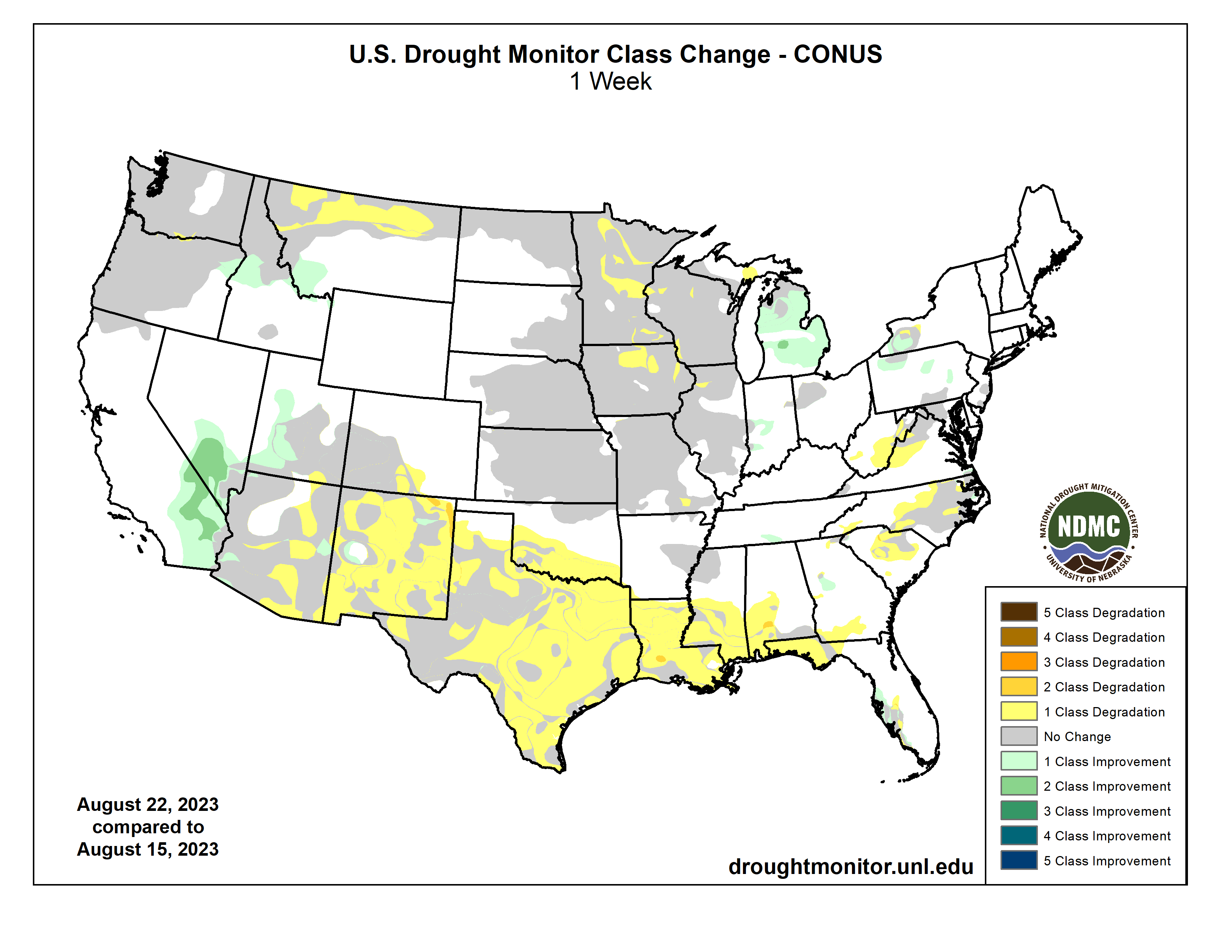
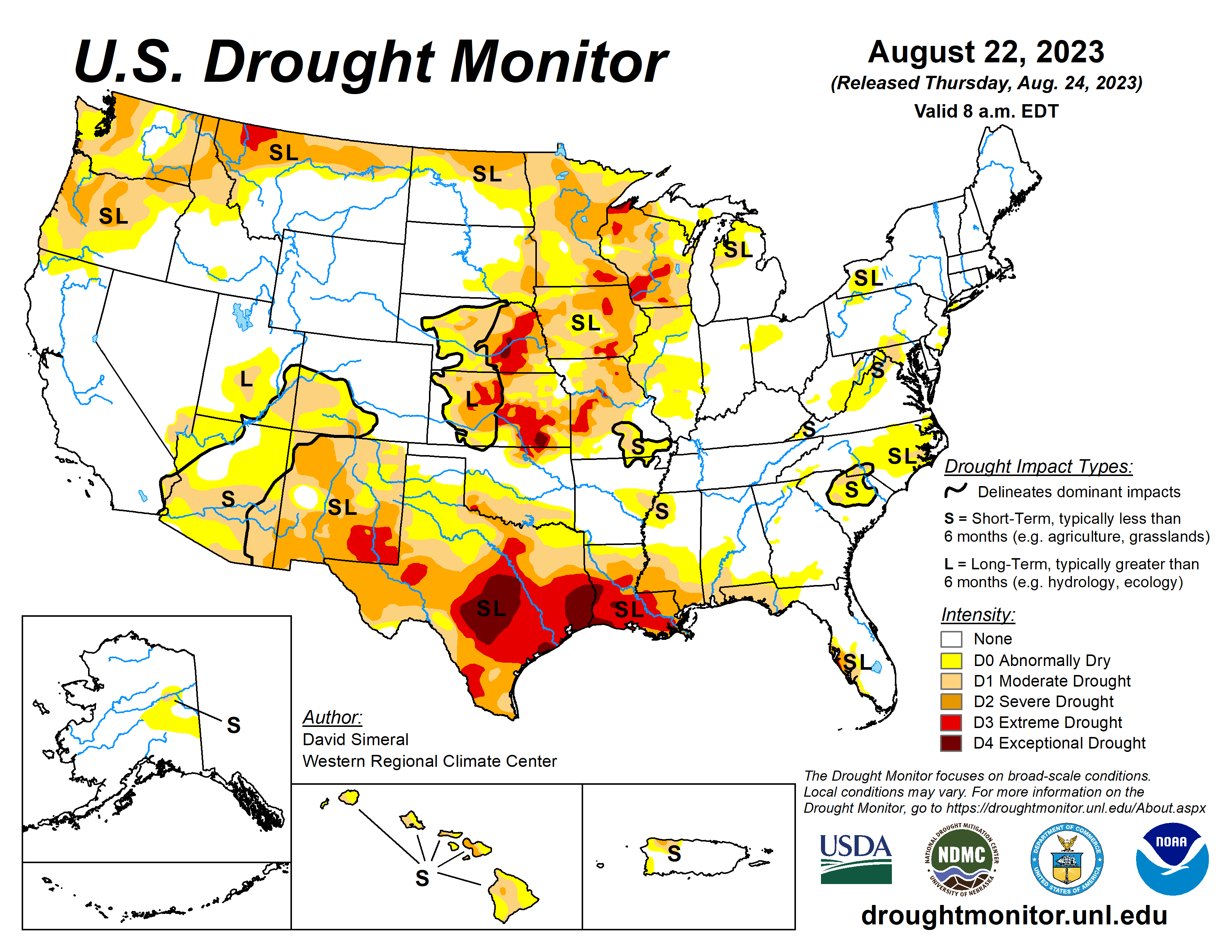
This Week’s Drought Summary

This U.S. Drought Monitor (USDM) week saw drought-related improvements on the map across southern portions of California and Nevada in association with the impacts of Tropical Storm Hilary, which made landfall in Southern California over the weekend and into Monday. The tropical storm, the first to make landfall in Southern California since 1939, brought record-breaking rainfall accumulations leading to widespread life-threatening flash flooding, mud and rockslides, and debris flows to parts of the region. Rainfall totals for the event ranged from 2 to 12 inches with the heaviest accumulations observed in higher elevations including the San Gabriel and San Bernardino Ranges, southern Sierra Nevada, Panamint Range in Death Valley National Park, and in the Spring Mountains near Las Vegas. In terms of the urban areas, the Los Angeles Basin received totals ranging from 2 to 5 inches, while the greater San Diego area received 1 to 3 inches and Palm Springs 2 to 4 inches. The rainfall led to removal of lingering areas of drought across the Mojave Desert and southern Nevada. In the Southwest, conditions in New Mexico saw statewide degradation on the map in response to a combination of both short- and long-term dryness across the state, including a weak monsoon season with 60-day rainfall deficits ranging from 2 to 6-inches. In the South, drought-related conditions have deteriorated rapidly during the past month across areas of Texas and Louisiana where persistent heat and rainfall shortfalls have led to drought expansion and intensification on the map this week. During the past two weeks, average maximum temperatures were 6 to 10+ degrees F above normal across Texas, southern Oklahoma, Louisiana, and southern Mississippi with reports of impacts related to human health as well as severe impacts to agriculture, vegetation health, and surface water conditions. Looking at the latest climatological data released by NOAA NCEI (through July 2023), Louisiana Climate Division 7 (Southwest Louisiana) observed its warmest May-July period on record, while Texas Climate Division 8 (Upper Coast) experienced its warmest June-July period on record. In the Midwest, continued areas of dryness led to degradations in portions of Minnesota, Iowa, and Wisconsin. In the Eastern Tier, some minor deterioration in drought-related conditions occurred in areas of the Carolinas as well as in the Panhandle of Florida…
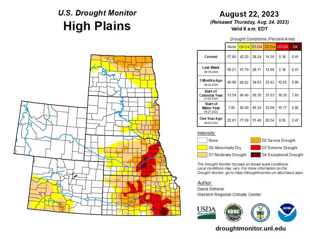
High Plains

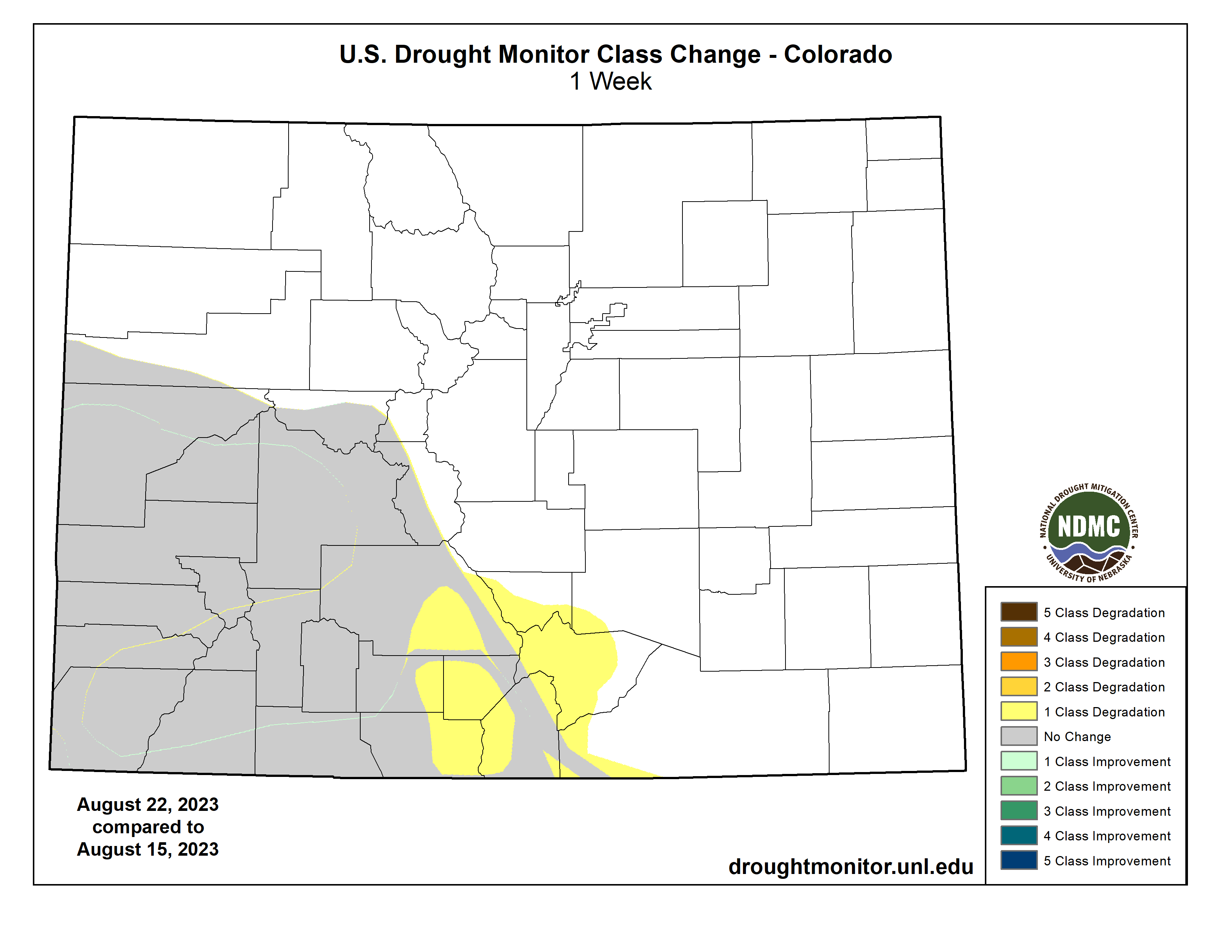
On this week’s map, no changes were made across the Plains states while some minor improvements were made in northwestern Wyoming and some degradations in south-central Colorado. Across the Plains, hot and dry conditions prevailed across much of the region this week with well-above normal temperatures (2 to 8 degrees F) observed, except for areas of the Dakotas where temperatures were a few degrees below normal. In terms of the overall drought situation, the past 60-day period has been marked with some improvements in response to above-normal precipitation across areas of Kansas and Nebraska. However, the longer-term dry signal has remained intact across areas of the region and continues to be reflected in various drought indicators including soil moisture and streamflow levels…
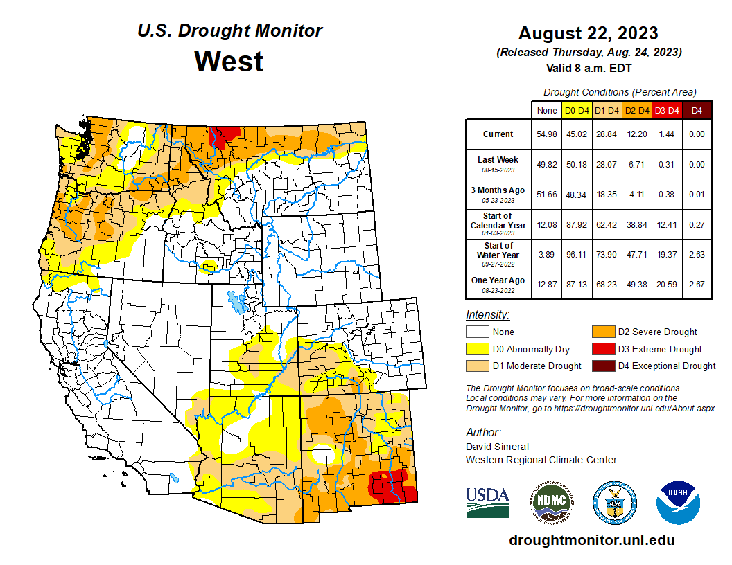
Colorado Drought Monitor one week change map ending August 22, 2023.

West

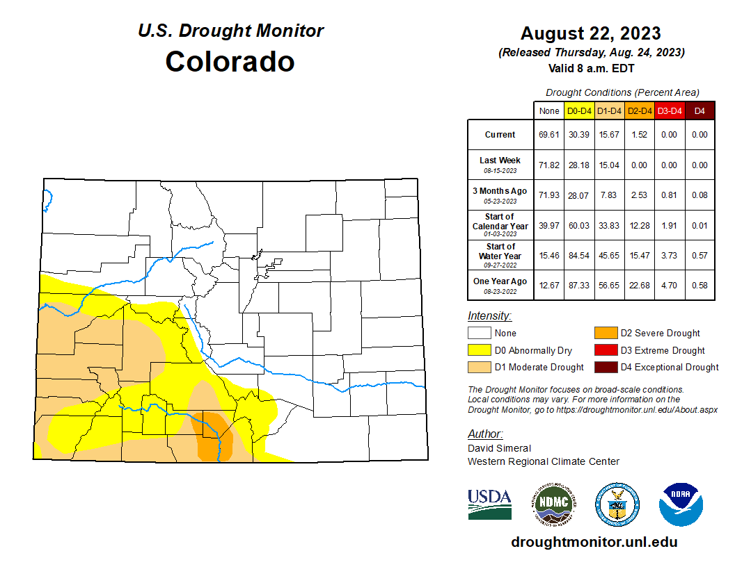
On the map, widespread improvements were made in drought-affected areas of southern California and Nevada in response to heavy rainfall accumulations associated with Tropical Storm Hilary and its remnant moisture that pushed northward across the Mojave Desert, Great Basin, and into the Pacific Northwest. The severe weather event helped to eliminate areas of lingering drought on the map across the Mojave Desert and in areas of southern Nevada. Likewise, conditions improved on the map in west-central Idaho and northeastern Oregon in response to this week’s rainfall. Conversely, continued dryness and below-normal streamflow activity led to an introduction of Extreme Drought (D3) in the Northern Rockies around Glacier National Park where streamflows on the North Fork of the Flathead River at Columbia Falls, Montana were in the 4th percentile. In north-central Montana, areas of Severe Drought (D2) expanded on the map due to a combination of factors including dry soils and below-normal precipitation during the past 60-day period. In the Four Corners states, the poor monsoon season and related precipitation shortfalls led to introduction of areas of Moderate Drought (D1) in southern and central Arizona as well as in south-central Colorado in the San Luis Valley. In New Mexico, the combination of short- and long-term precipitation deficits, poor soil moisture, and rangeland conditions led to widespread deterioration on the map across much of the state.

South

In the South, drought-related conditions continued to deteriorate as the hot and dry pattern continued across most of the region. Many impact reports came in this week emphasizing the rate at which the impact of the persistent heat is taking its toll. In both Louisiana and areas of Texas, numerous impacts are being observed including declining soil moisture, poor vegetation health, impacts within the agricultural sector, and poor surface and groundwater conditions. The combination of these factors led to expansive deterioration on the map in areas of Texas, Louisiana, and southern Oklahoma including expansion of areas of Extreme Drought (D3) and the introduction of Exceptional Drought (D4). For the week, average temperatures across the region were above normal with Louisiana, Oklahoma, and Texas observing temperatures ranging from 4 to 10+ degrees F above normal. Conversely, temperatures were near to slightly below normal across northern portions of Arkansas, Mississippi, and Tennessee. In terms of precipitation, the region was very dry except for some isolated areas of South Texas and southeastern Louisiana which received light accumulations…

Looking Ahead

The NWS WPC 7-Day Quantitative Precipitation Forecast (QPF) calls for light-to-moderate precipitation accumulations ranging from 1 to 3+ inches across portions of the Four Corners states as well as areas of Far West Texas. Likewise, similar accumulations are expected across areas of the Southeast, Mid-Atlantic, and the Northeast. In the eastern and northern portions of the Midwest, lighter accumulations (< 1 inch) are forecasted. The CPC 6-10Day Outlooks call for a moderate-to-high probability of above-normal temperatures across much of the conterminous U.S. including the West, South, Southeast, Plains states, and western portions of the Midwest. Conversely, below-normal temperatures are expected across the Lower Midwest, Mid-Atlantic, and the Northeast. In terms of precipitation, below-normal precipitation is expected across the Plains states, Midwest, and far western extent of the Northeast, while above-normal precipitation is forecasted for much of the western U.S. and across much of the Eastern Seaboard.

US Drought Monitor one week change map ending August 22, 2023.

Federal court vacates approval of #Utah oil-train project opposed by #Colorado local governments: Court of Appeals finds ‘numerous NEPA violations’ in analysis of Uinta Basin Railway risks — Colorado Newsline #ActOnClimate #KeepItInTheGround #ColoradoRiver #COriver

A Union Pacific train travels along the Colorado River near Cameo on May 16, 2023. (Chase Woodruff/Colorado Newsline)

Click the link to read the article on the Colorado Newsline website (Chase Woodruff):

A federal court on Friday [August 18, 2023] sent regulators back to the drawing board on their approval of a new short-line railroad in the oil fields of eastern Utah, finding major flaws in how the federal Surface Transportation Board analyzed the risks of increased oil-train traffic through western and central Colorado.

The ruling from the U.S. Court of Appeals for the D.C. Circuit is a victory for Colorado local governments and environmental groups who oppose the construction of the Uinta Basin Railway, an 88-mile rail extension that would allow drillers in Utah to ship large volumes of crude oil to Gulf Coast refineries. An estimated 90% of the resulting traffic — as many as five fully loaded, two-mile-long trains of oil tankers per day — would be routed through Colorado.

The ruling, issued by Judge Robert Wilkins, grants in part a petition filed by Eagle County against the STB’s approval of the railway’s construction, and the environmental impact statement supporting the approval. Eagle County was joined by five environmental groups in suing to block the project, which is backed by a public-private partnership between Utah county governments and industry.

“The deficiencies here are significant,” the Court of Appeals ruling states. “We have found numerous (National Environmental Policy Act) violations arising from the EIS, including the failures to: (1) quantify reasonably foreseeable upstream and downstream impacts on vegetation and special-status species of increased drilling in the Uinta Basin and increased oil-train traffic along the Union Pacific Line, as well as the effects of oil refining on environmental justice communities the Gulf Coast; (2) take a hard look at wildfire risk as well as impacts on water resources downline; and (3) explain the lack of available information on local accident risk.”

In a joint statement, Democratic U.S. Sen. Michael Bennet and Rep. Joe Neguse, who have urged multiple federal agencies to put a stop to the railway project, called Friday’s ruling “excellent news.”

“The approval process for the Uinta Basin Railway Project has been gravely insufficient, and did not properly account for the project’s full risks to Colorado’s communities, water, and environment,” said Bennet and Neguse. “We’re grateful for the leadership of Eagle County and the many organizations and local officials around Colorado who made their voices heard.”

The court’s ruling vacates key sections in the EIS conducted by the STB prior to its 4-1 vote in December 2021 to approve the railway, as well as a so-called biological opinion prepared with the help of the U.S. Fish and Wildlife Service to evaluate “downline” risks to endangered species and critical habitats along the Colorado River. It also faults the STB for failing to scrutinize what critics have alleged is the Uinta Basin Railway project’s shaky financing.

“The Board failed to weigh the Project’s uncertain financial viability and the full potential for environmental harm against the transportation benefits it identified,” the ruling concludes.

The ruling remands the project’s application for approval back to the STB “for further proceedings in accordance with this opinion.”

The Price River near Kyune, Utah, where the proposed Uinta Basin Railway would meet the existing Union Pacific line, is pictured from an Amtrak passenger train on June 5, 2023. (Chase Woodruff/Colorado Newsline)

New #Colorado #climate report says state will continue to heat up, but whether it will dry out is unclear — Fresh Water News #ActOnClimate

A rancher digs a boot heel into the dry ground of the Little Bear Ranch near Steamboat Springs, Colo., during the Northwest Colorado Drought Tour on August 11, 2021. Credit: Dean Krakel, special to Fresh Water News.

Click the link to read the article on the Water Education Colorado website (Jerd Smith):

Colorado will certainly grow warmer between now and 2050, but whether it will become wetter due to this warming isn’t clear yet, according to a new state climate report due out next month.

The draft report, 2023 Climate Change in Colorado, shows that scientific models predict with high confidence that the state will see temperatures rise 2.5 degrees to 6 degrees Fahrenheit by 2050, but models looking at how this warming trend will impact water are much less clear. Some projections indicate the state could see more precipitation, and others show it will get less, according to Becky Bolinger, assistant state climatologist and an author of the new report.

“Some models are showing wetter, some drier, and we have a lot of uncertainty about which direction it is going to go,” Bolinger said.

“Since 2008 we have consistently experienced drier conditions. If you were to do a simple trend, it would appear we have gone drier, but there is a lot of variability. It is possible we will end this dry period and go into a wetter period. It is also possible that we could go into a drier period,” she said.

The Climate Change in Colorado report was produced by the Colorado Climate Center at Colorado State University, with support from the Colorado Water Conservation Board and Denver Water.

Bolinger said that this new third edition of the climate report, two previous editions were published in 2008 and 2014 respectively, is designed to serve as a guide for any community, or farm, or industry in Colorado working to prepare for a warmer future.

Despite the uncertainty about water, new modeling shows that snow, soil moisture and streamflows will likely decline, heat waves, fires and droughts will increase in frequency, and extreme rain storms and flooding are also likely to worsen.

Among the hardest-hit sectors will be agriculture, Bolinger said, in part because evaporation rates will rise as temperatures rise. As larger amounts of water are lost to the atmosphere, plants will need more.

In addition, because spring snows will melt and peak runoff will occur sooner, farmers will likely have to change planting schedules and figure out how to make their irrigation water last longer.

“It’s going to get harder to farm,” Bolinger said.

Out on Colorado’s Eastern Plains, at the Greeley-based Central Colorado Water Conservancy District, that’s not necessarily a surprise.

Crop residue November 4, 2021. Photo credit: Joel Schneekloth

Randy Ray, executive director of the district, said farmers have already begun using comparatively new methods to stretch their water supplies and to help the soil retain moisture. These techniques, which include dramatically reducing the tilling of soils and using compost to help them retain water, are becoming more and more common, Ray said.

Irrigators also continue to call for more storage, whether it is in a reservoir or an aquifer, to give them more flexibility in how they manage irrigation water.

“I’m confident that the American farmer is going to be able to adapt,” Ray said. “It probably isn’t going to be easier and they are going to adapt with different crops and different methods of irrigation.”

Water utilities across the state have already begun analyzing what the dramatic warming trends mean for urban water supplies.

The City of Grand Junction has done forecasts that show worst-case drought scenarios could slash annual water supplies by more than half, to 6,400 acre-feet, down from the 15,000 acre-feet its system generates and stores each year. It also figures that long-term warming will drop the number by an additional 10%, according to Mark Ritterbush, Grand Junction’s manager of water services.

“By 2039, we may need to develop a different water supply in the event the worst-case scenario happens. We have the water rights, we would just need to upgrade our treatment technology to utilize those new sources,” he said.

Having more refined climate data and experts, such as those available at the Colorado Climate Center, is going to be helpful, he said.

“I feel good about [our forecast], but you never really know,” he said. “I’d like to know if that 10% we came up with is accurate.”

Jerd Smith is editor of Fresh Water News. She can be reached at 720-398-6474, via email at jerd@wateredco.org or @jerd_smith.

Colorado statewide annual temperature anomaly (F) with respect to the 1901-2000 average. Graphic credit: Becky Bolinger/Colorado Climate Center