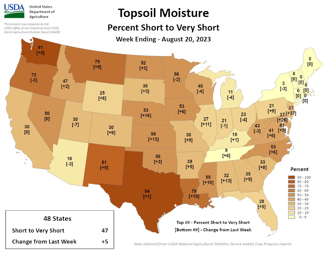
For the week ending 8/20, 47% of CONUS is rated short/very short, a 5% increase compared to last week. More short soil moisture emerged in mid-Atlantic states & worsened across the S & SE U.S. with TX, NM & LA hit hard.

For the week ending 8/20, 47% of CONUS is rated short/very short, a 5% increase compared to last week. More short soil moisture emerged in mid-Atlantic states & worsened across the S & SE U.S. with TX, NM & LA hit hard.
From email from the Colorado Water Conservation Board:
August 22, 2023 (Denver, CO) – The Colorado Department of Natural Resources and the Colorado Water Conservation Board announced that Lauren Ris has been selected as the next Director of the Colorado Water Conservation Board.
Lauren Ris, who has held the position of Deputy Director of the Colorado Water Conservation Board (CWCB) since 2017. She is a water policy expert who is passionate about solution-focused water resilience in the state.
”We are excited to welcome Lauren Ris at this important time as we continue to take bold and innovative action to preserve and protect Colorado’s precious water resources. We know that here in Colorado, water is the lifeblood of our state and we will all benefit from Ris’s leadership and expertise on this issue,” said Gov. Polis.
“What’s most inspiring to me about working in the water sphere, is the high degree of collaboration that’s required. It’s not a political issue, it’s a geographical issue—and water is a resource that every sector in Colorado can’t do without. It requires us to work together and find win-win solutions for hard problems,” said Lauren Ris, Director, Colorado Water Conservation Board. “Having grown up in Colorado, it’s important for me to see that we have a continued pathway for economic growth, agricultural viability and environmental resiliency in our state.”
Ris holds a Bachelors in English and Environmental Science from Willamette University and a Masters in Natural Resource Policy and Conservation Biology from the University of Michigan. She previously worked as a Committee and Policy Staff Fiscal Analyst for the Colorado Legislative Council, a Legislative Liaison for the Colorado Department of Natural Resources (DNR), Assistant Director for Water in the DNR, and most recently, the Deputy Director of the CWCB.
A major priority, Ris says, is continuing the momentum of the Colorado Water Plan. “We are positioned well with the recent release of the updated 2023 Water Plan, and it’s absolutely critical that now we check off the boxes and make real tangible progress.”
“I would like to see us find creative solutions that allow us to maximize every drop of water in Colorado,” said Ris. “That includes doubling down on municipal conservation efforts like urban landscape transformation. I’d also like us to take a hard look at some of the barriers that are impeding water sharing agreements–the creative, collaborative agreements that allow municipalities to lease water from agricultural operations during times when they aren’t irrigating while continuing to have viable agriculture.”
Ris also plans to ensure CWCB continues to support former CWCB Director Rebecca Mitchell in her new role of the State of Colorado’s Commissioner to the Upper Colorado River Commission—by providing the best policy and technical expertise to the state on the challenges facing the Colorado River Basin.
“I am extremely excited about Lauren Ris’ elevation to Director of the Colorado Water Conservation Board. Her leadership, insight, strong relationships, collaborative nature, and deep knowledge of Colorado water issues will enable her to seamlessly step into the Director role,” said Dan Gibbs, Executive Director, Colorado Department of Natural Resources. “Colorado faces many future water challenges, but Lauren has the experience and skills to help our state build on the great work of CWCB while ensuring the future sustainability of our critical water resources.”
“Ris has played a pivotal role in the agency for years and has provided seamless support as Interim Director,” said Greg Felt, Board Chair of the Colorado Water Conservation Board. “The agency, and Colorado’s water future, will be in good hands under Lauren’s leadership.”

Click the link to read the article on the NOAA website (Haley Thiem):
Hurricane Hilary made waves last week as it churned off the west coast of Mexico and tracked north toward Southern California. The tropical cyclone rapidly intensified, which is an increase in maximum sustained winds at least 30 knots (35 mph) in a 24-hour period, peaking at major, Category 4 hurricane status on Friday. The National Hurricane Center (NHC) issued its first ever tropical storm watch for parts of southern California (later changed to a warning) as the system approached the coast.
While Hilary did not make landfall in southern California, it did make landfall over the northern Baja California Peninsula in Mexico as a tropical storm on Sunday according to the NHC, and maintained tropical storm status as it crossed into Southern California on Sunday.
Hilary has made a very short list of storms that have maintained at least tropical storm status while tracking across parts of Southern California, the last of which was Hurricane Nora in 1997, according to NOAA historical hurricane track data.
It is quite rare for a tropical storm or hurricane to maintain its strength and tropical characteristics in this part of the world, due to cool ocean waters and currents as well as prevailing trade winds that blow from east to west in this area.
Cool ocean waters
Tropical cyclones need warm ocean waters, of at least 79 degrees Fahrenheit (26 degrees Celsius), to develop and/or maintain their strength. Waters off the U.S. West Coast generally do not reach this threshold in large part due to the California Current which brings cold waters from Alaska south along the West Coast and northern Baja California.
Sea surface temperatures are typically in the 50s and 60s off the central and southern Pacific Coast, according to data from NOAA’s National Centers for Environmental Information. However, in late summer and into September, the waters may sneak into low 70-degree territory, which is the most common time to see remnants of tropical systems impact this region.
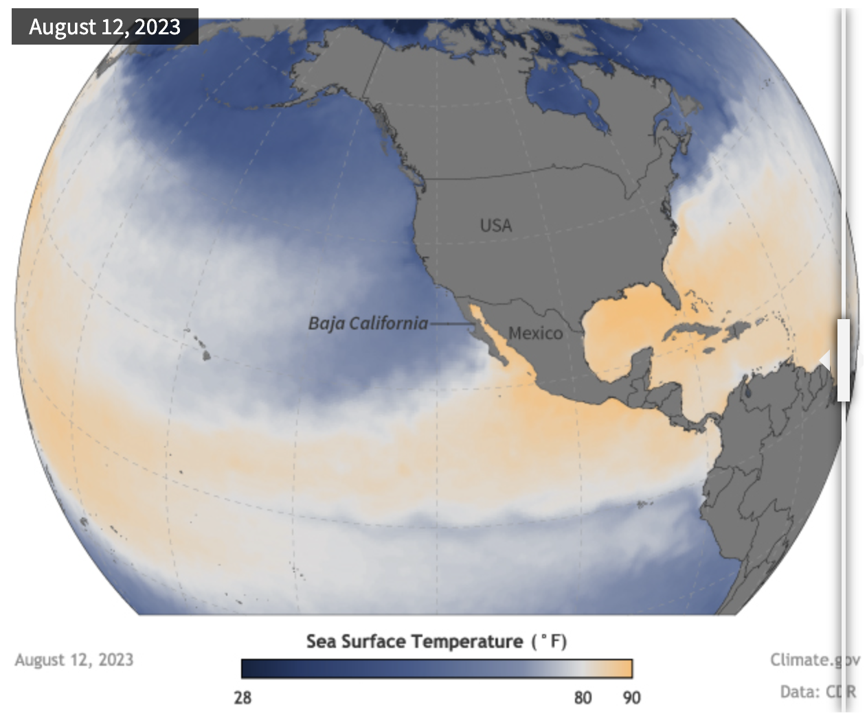
Despite current sea surface temperatures being slightly warmer than normal just off the Baja California Coast and portions of the Southern California Coast, according to NOAA’s Coral Reef Watch, sea surface temperatures were only registering between 65 and 72 degrees over the weekend. This is one reason Hilary was weakening as it approached Mexico and the United States.
Prevailing winds
Another reason it is very rare to see tropical cyclones impact the US West Coast is that the region’s prevailing winds—the northeast trade winds—blow generally westward, away from the coasts of the United States and Mexico. These winds tend to steer any tropical systems toward the open Pacific Ocean. They also aid upwelling ocean currents along the coast. The winds push water from the ocean’s surface westward, which allows deeper and cooler ocean waters to rise to the surface.
With Hilary, the normal easterly winds were shifted farther away from the coastline. Instead there was a strong ridge of high pressure over the south-central United States and mid- to upper-level low-pressure system off the West Coast, which allowed the storm to be pulled much farther north in the flow between the two systems, as was noted by a NHC discussion on Friday.
Despite weakening, Hilary brought flooding rains and gusty winds to Baja California and Southern California an area that is not used to seeing tropical rainfall, especially in their dry season, which typically runs from May to September.
So even though direct hurricane or tropical storm landfalls to the West Coast are quite rare, even indirect impacts from tropical cyclones can have a major impact, especially when it comes to rainfall. For rainfall and other forecast information for your area, visit Weather.gov.