Click on a thumbnail graphic to view a gallery of drought data from the US Drought Monitor website.
Click the link to go to the US Drought Monitor website. Here’s an excerpt:
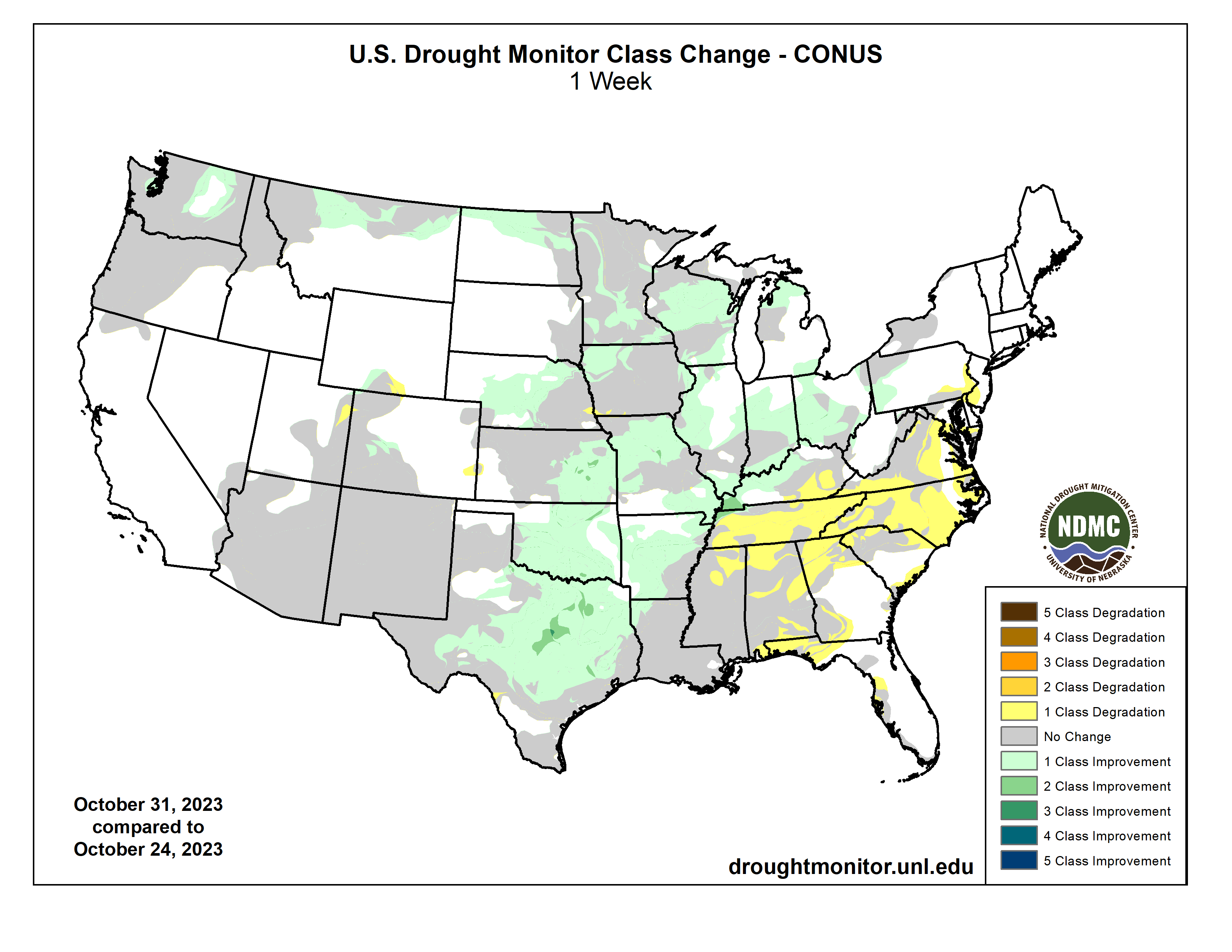
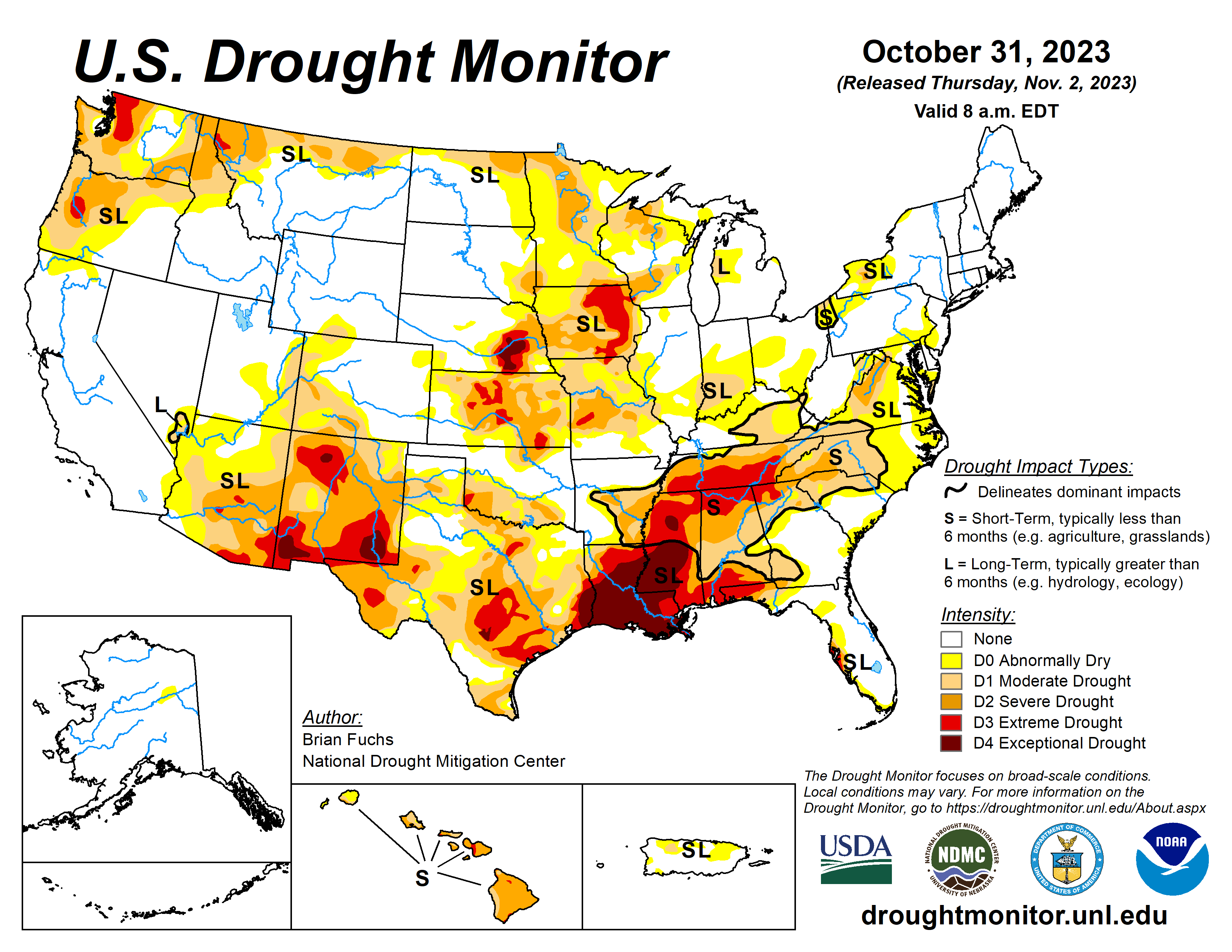
This Week’s Drought Summary
One of the first significant storm systems of the season impacted the Plains and into the Midwest. Not only did the region see widespread precipitation, but the first real cold air also dropped in from Canada. Snow was widespread through the northern Plains and significant rain fell across portions of Kansas, Missouri, Oklahoma, Texas and Arkansas as well as in Wisconsin. The Southeast continued to be dry and warmer than normal while cold air dominated portions of Montana into Wyoming during the last week…
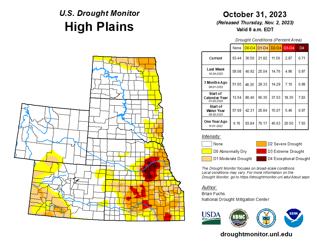
High Plains
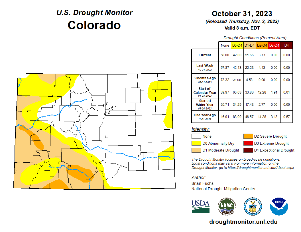
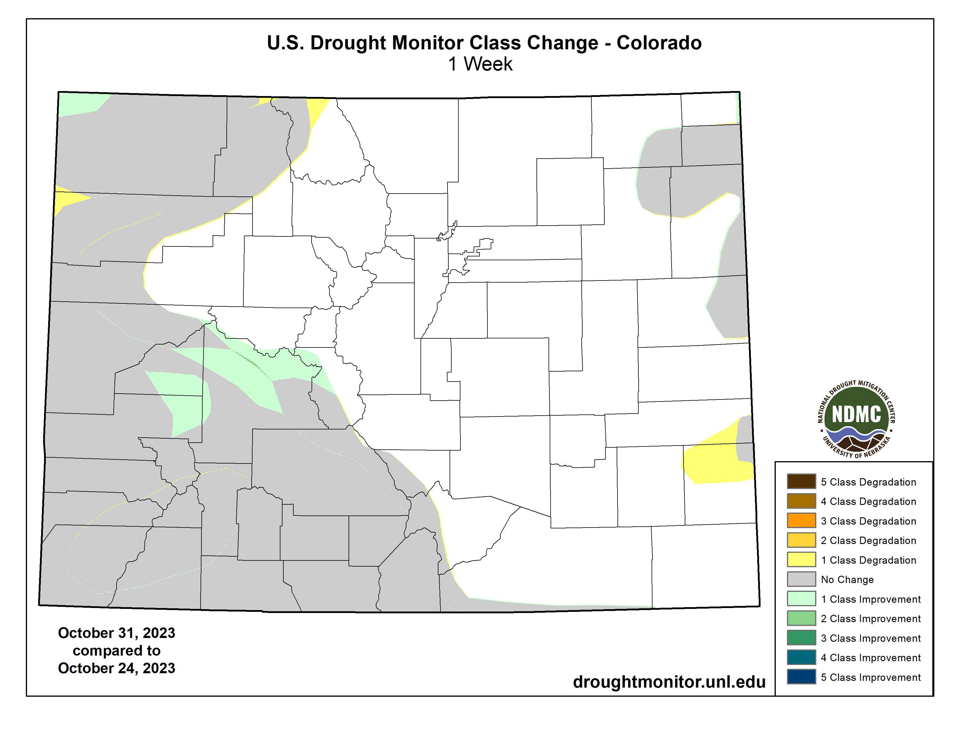
Significant precipitation was recorded in North Dakota, northeast Nebraska, and central and southeast Kansas. Some of the precipitation in these regions came as snow and it is anticipated that much of the ensuing melt-off will get moisture into the soils. Temperatures were cooler than normal over most of the region with the greatest departures over the western Dakotas where temperatures were 10-15 degrees below normal. A full category improvement to the drought intensities was made over northern North Dakota, central and western Nebraska, and southeast Kansas. Some expansion of abnormally dry conditions took place over eastern Colorado and western Kansas as well as southern Wyoming…
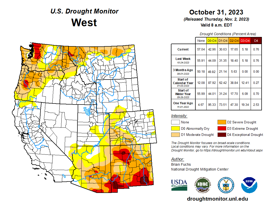
West
Much of Montana and central to western Colorado saw the most significant precipitation for the week, with good amounts of snow in the higher elevations. Great Falls, Montana, recorded over 8 inches of snow for the week and Havre had 5.7 inches. Crested Butte, Colorado, recorded 13 inches of snow for the week while Steamboat Springs had 4.9 inches. Temperatures were below normal for almost all of the region with most areas 5-10 degrees below normal. Areas of Arizona and New Mexico were near normal to up to 5 degrees above normal while Montana and Wyoming received the coldest air and temperatures for the week were 20-25 degrees below normal. The precipitation in Montana allowed for improvement to the drought conditions, mainly in the northern portions of the state. Some improvements were made in western Colorado while there was some slight expansion to the abnormally dry conditions in Utah. Improvements were also made this week in central Washington as the most recent wetter pattern started showing up in the drought indices and indicators, allowing for improvements on the map…
South
Temperatures were mixed for the week as areas impacted by the strong storm system through the region were 1-3 degrees below normal while those further to the west were 9-12 degrees above normal for the week. Significant rain fell over most of Oklahoma and Texas and into northern Arkansas this week, allowing for improved drought conditions. Lake Waco, in north central Texas, gained 112,000 acre-feet over the past week, taking it from its historic low of 54.5% of conservation storage to 114% of conservation storage. Most of these areas had a full category of improvement to their drought status, with some areas of Texas seeing multiple category improvements to the drought intensity. A full category of improvement was made over much of Arkansas this week with a reduction of moderate and severe drought conditions…
Looking Ahead
Over the next 5-7 days, much of the southern half of the U.S. is expected to be dry with little to no precipitation anticipated in areas south of a line from central California to Nebraska and into the Mid-Atlantic. The Pacific Northwest as well as the northern Plains and Midwest are expected to have the most active weather and precipitation. Temperatures are expected to be warmer than normal over the Southwest, southern Plains and Southeast with departures of 8-10 degrees above normal in west Texas and into New Mexico. Cooler-than-normal temperatures are anticipated over northern California, the northern Plains and upper Midwest with departures of 5-8 degrees below normal.
The 6–10 day outlooks show a good chance of a warmer-than-normal pattern over the southern U.S. and the Pacific Northwest. The best chance for below-normal temperatures is over the Great Lakes and New England regions. There is a high likelihood that temperatures over Alaska and Hawaii will also be above normal. The greatest chances of above-normal precipitation will be over northern California and southern Oregon while coastal areas from North Carolina to Maine will also have above-normal chances of recording above-normal precipitation. The best chance of below-normal precipitation is over the southern Plains and into Arizona and New Mexico.