The Grand Canyon is magical in any season, but fall may take the cake for the perfect boating season on that stretch of the Colorado River. Cool mornings, warm days that are still long enough to dry out your gear after a day of getting hammered by huge waves, and starry nights that appear after the sun has dipped below the ramparts of rock in the distance. This year, canyon explorers are lucky to experience the additional gift of abundant sand from the High Flow Experiment(HFE) that was conducted in April, 2023.
I was on the river a couple of weeks ago, conducting survey activities alongside scientists from the United States Geological Survey’s (USGS) Grand Canyon Monitoring and Research Center (GCMRC). This is part of a long-running program to quantify impacts to various resources throughout the canyon from the construction of Glen Canyon dam in the early 1960s. Since the early 1990’s, scientists from GCMRC and Northern Arizona University have been using geodetic survey techniques to measure sand volume, in three dimensions, to a select group of around 40 beaches and sandbars from Lee’s Ferry to Diamond Creek. The changes are compared year over year and show trends of how these beaches shrink or grow based on Colorado River flow conditions over the year. These measurements are coupled with photographic evidence from cameras also placed throughout the canyon to observe these changes across an entire year or multiple years.
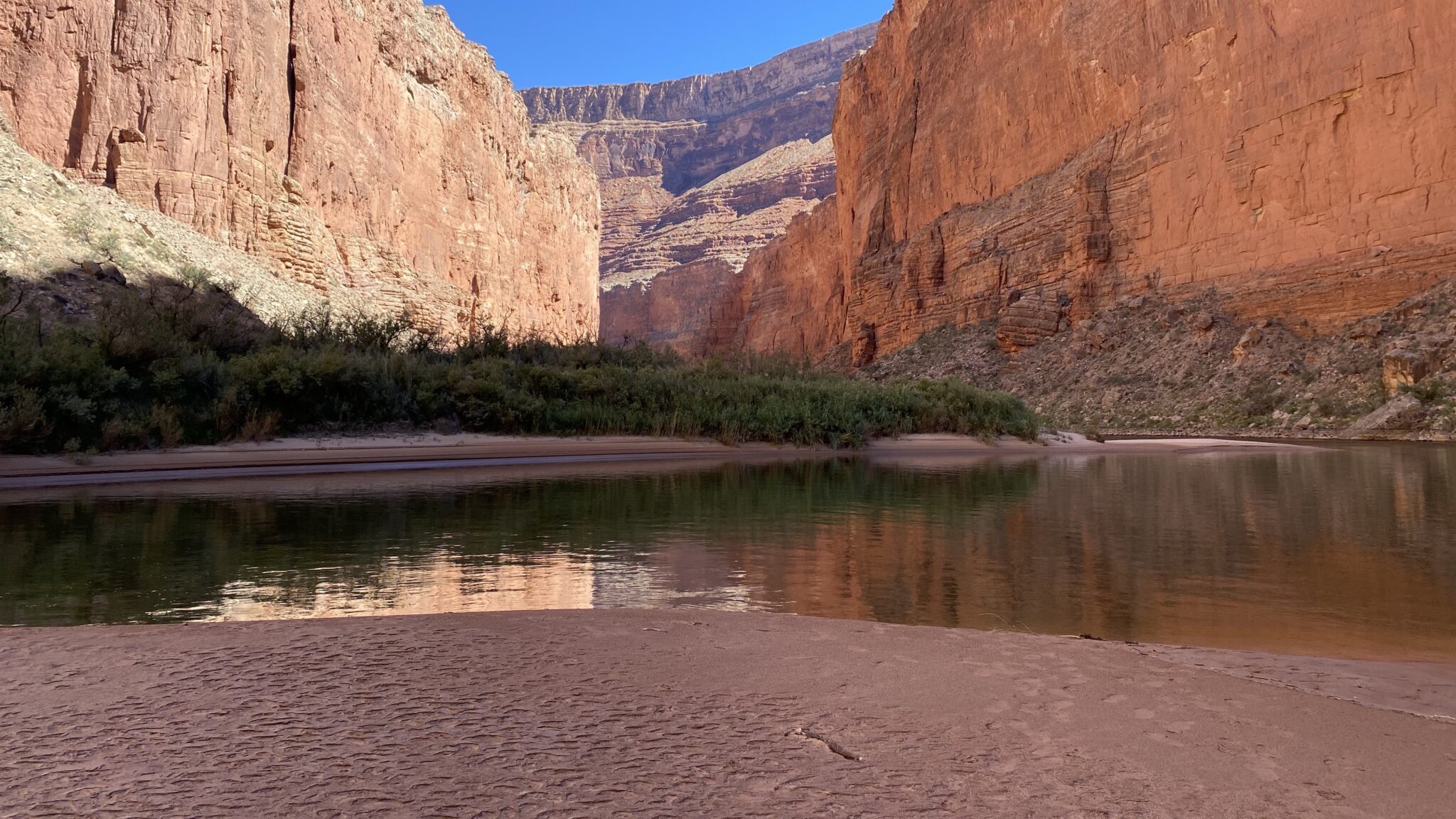
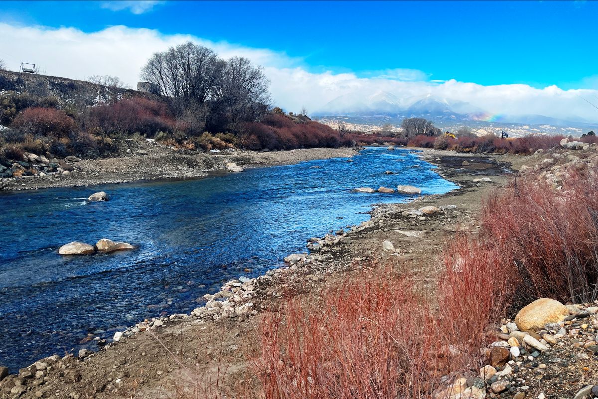
The beach below Redwall Cavern | Photo by Sinjin Eberle
My observation? There is a lot of sand down there, with huge beaches the likes of which I have not seen in many years. The last time an HFE was conducted in the canyon was 2018, and the last time a spring high-flow was conducted was in 2008. Without these HFEs, the sediment-reduced water coming out of Glen Canyon dam actually erode beaches and sandbars, deteriorating conditions over time that impact not only beaches for recreation but allow greater encroachment of vegetation as well as the gradual uncovering of cultural resources near the river throughout the 277-mile corridor. Nearly every beach that was either surveyed, seen from a distance, or camped on was larger – much larger – than what I have seen before. And many of the beaches actually had two stages of sandbars; a lower, very large bench of flat sand, and a higher, more piled berm of sand behind it which formed a tall dune crest or back-bench of soft sand. The volumes we witnessed in places were surprising to say the least.
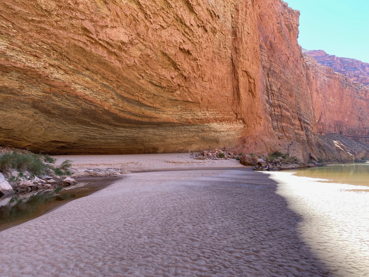
The beach at Buck Farm illustrates the two-bench effects from this summer. The foreground shows sand deposited up to about 19,000cfs, while the distant bench shows sand up to about the 42,000cfs elevation. Photo by Sinjin Eberle
This configuration of sand was created by the flow regime that was the HFE itself as well as the summer flows that followed. When the HFE was conducted in mid-April, about 42,000 cubic feet per second of water (a very high flow!) was released continuously for 72 hours before the flows were brought back down to normal (~10,000cfs). That mobilized more than 1.5 million tons of sand that had been deposited by the Paria River (roughly 15 miles downstream) over the past couple of years – this is the sand that rebuilt the beaches and sandbars I saw on my trip. After the HFE, though, Bureau of Reclamation moved nearly 10 million acre-feet of water from Lake Powell to Lake Mead, creating unusually high flows (topping out at about 19,000 cfs) each day all summer long. These higher daily flows actually stripped some of that new sand at the lower elevations of the channel, shooting it downstream. In September, Reclamation pulled the flows back a bit more, revealing those lower, expansive benches of sand.
Where is all this leading? Well, in early October Reclamation issued a Notice of Intent for scoping some supplemental rules related to the Long-Term Experimental Management Plan, or LTEMP. While much of what is being considered is related to a situation where invasive small mouth bass have come into the canyon from Lake Powell, threatening the humpback chub population in the canyon, it also is proposing to amend the guidelines for how HFEs are conducted. The new rules would make it so the period of time that sand is accounted for in the canyon would be longer (on an annual basis rather than two, shorter timeframes) as well as lengthening the one of the periods that HFEs could be conducted (importantly making it so HFEs could be triggered in May and June, which they cannot be under the current rules.)
Importantly, you can comment on these new rules. You can read more at the Notice of Intent link above and send your comments by email to LTEMPSEIS@usbr.gov. But you only have until November 3 to make your voice heard.
Seeing these beaches and sandbars firsthand is an extraordinary experience, but being able to speak up for the canyon and all that depend upon it is both a privilege and responsibility. I know that I for one am proud to be able to put my energy into making my voice heard for such a special place. And for even more Grand Canyon exploration, check out our award-winning storymap, Caught in the Middle, which we published last spring.
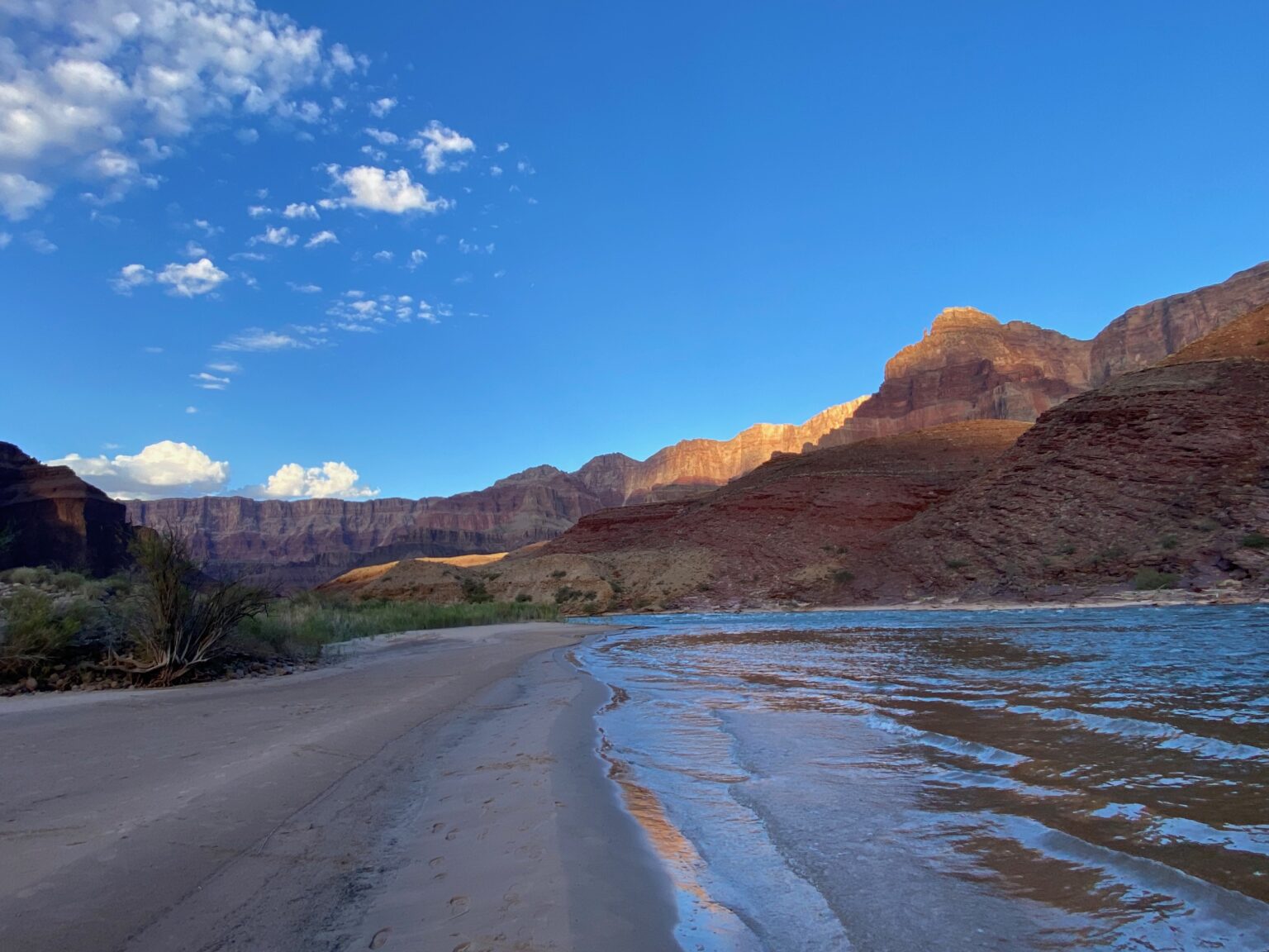
Sunset paints the walls towering above Basalt Camp in Grand Canyon | Photo by Sinjin Eberle
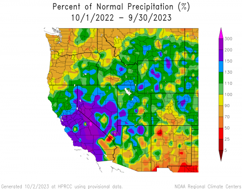
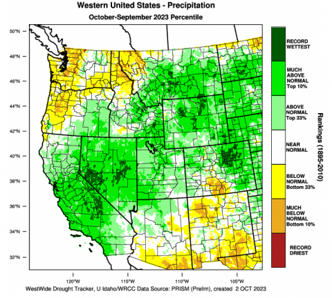
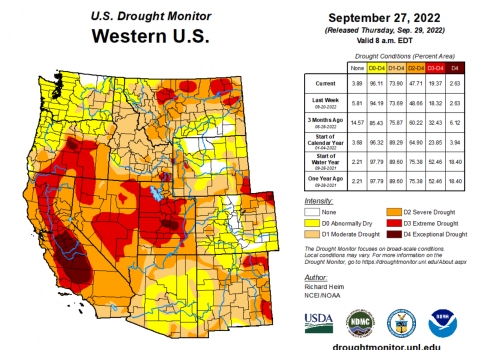
The 2023 water year began with nearly two-thirds of the Intermountain West in drought. Much-above average precipitation fell across nearly the entire region during winter and many long-term monitoring sites in Utah and western Colorado broke snow-water equivalent (SWE) records. Above average winter precipitation and snowfall caused above-to-much-above average seasonal streamflow volumes across nearly the entire region. Wet winter conditions alleviated drought in many locations. An active North American monsoon season caused areas of above average precipitation in late summer and fall which alleviated drought conditions in all but 8% of the region.
Precipitation during the 2023 water year was above normal to much-above normal for much of the region, except for a large region of south-central Colorado and pockets of eastern Utah and eastern Wyoming where precipitation was 50-90% of normal. Much-above normal conditions of up to 200% occurred in pockets of western and northern Wyoming, east of the Denver area in Colorado, and southwestern Utah. Record wet conditions occurred in much of northeastern Colorado, particularly along the Front Range and counties surrounding Denver, regions of northern Wyoming from Park and Hot Springs to Sheridan, Johnson, and Crook Counties, and southeastern Wyoming near Cheyenne and Laramie.
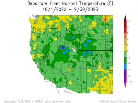
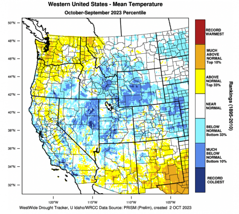
Temperatures during the 2023 water year were below normal for the region, besides small pockets of slightly-above normal temperatures in each state, particularly in the San Luis Valley region of Colorado. Temperatures ranged from near-normal to -6°F below normal throughout the region, with the coldest temperatures from normal observed in northwestern Colorado, northwestern and northeastern Utah, and western Wyoming. Based on mean temperature data from 1895-2010, the region experienced much-below normal temperatures, particularly in southwestern Utah, western and central Wyoming, and eastern Colorado. Record cold temperatures were observed in small pockets of southwestern Utah and Fremont County in Wyoming.
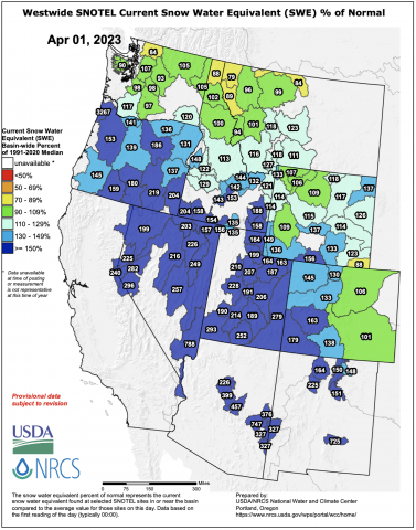
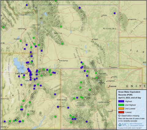
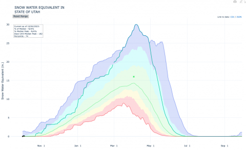
April 1st snow-water equivalent was above average to much-above average for nearly all river basins in Colorado, Utah, and Wyoming. Many river basins and individual SNOTEL sites received record SWE accumulation during the 2023 water year; as a statewide average Utah received record SWE accumulation in 2023, breaking the previous record set in 1983. The largest snowpacks were found in Utah and western Colorado including record SWE accumulation in the Lower Bear, Dolores, Lower Green, Jordan, Lower San Juan, and Weber River Basins.
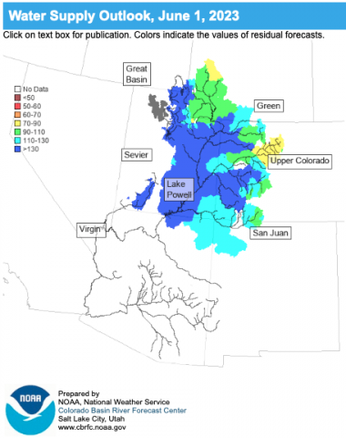
Seasonal runoff volume was above-to-much-above average for all regional river basins except for the Arkansas River Basin where spring runoff volume was slightly-below average. Seasonal runoff volume for the Upper Colorado River Basin was 157% of average. Seasonal streamflow volumes were highest in Utah and western Colorado and lowest in the Arkansas and South Platte River Basins.
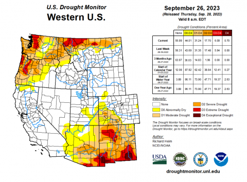
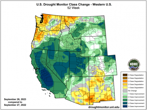
Drought was removed from nearly all of the Intermountain West during the 2023 water year. In late September 2022, drought covered 64% of the region. By late September 2023, only 8% of the region was in drought. In Utah, where D3-D4 (extreme to exceptional) drought covered nearly 60% of the state at the start of the water year, extremely high winter precipitation and an active monsoon in August-September caused statewide drought coverage to fall to 5% by September 2023. A portion of northwest Wyoming remained in drought after winter 2023, but a wet August completely removed drought from Wyoming. In Colorado, deep winter snowpacks aided the removal of drought conditions only to see drought return by August. Finally, drought conditions on Colorado’s Eastern Plains were completely removed after very wet conditions in May and June.
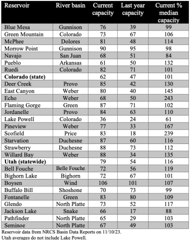
Reservoir storage conditions improved significantly across the entire region except for Lake Powell which saw a more modest improvement of conditions. Reservoir storage is average to above average for nearly every major reservoir in the region. The huge 2023 snowpack brought much above average runoff volume into Lake Powell. By July 2023, Lake Powell rose 60 feet increasing from 24% to 36% of capacity by the end of the 2023 water year.
November 10, 2023 – CO, UT, WY
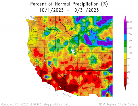
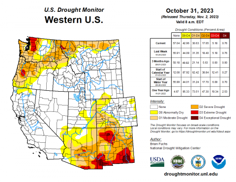
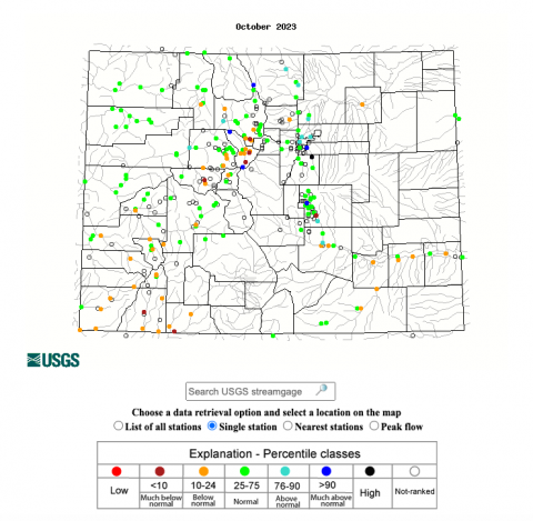
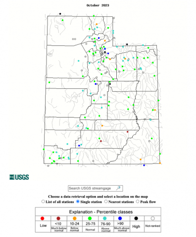
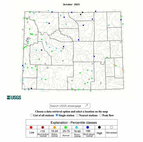
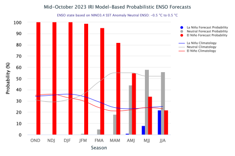
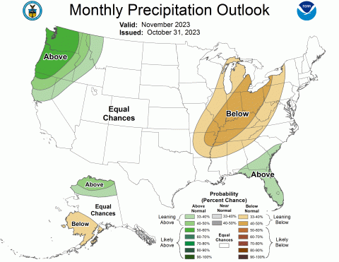
October precipitation varied throughout the region, generally with above normal conditions in Wyoming and below normal conditions in Colorado and Utah. October temperatures were near-normal across the region, leaning towards the warmer side overall. Regional snow-water equivalent (SWE) was mixed, with the greatest variance of much-above to much-below normal SWE in Utah. Drought conditions slightly expanded during October and at the end of the month, drought covered 11% of the region. El Niño conditions persisted during October and are expected to remain through late spring. NOAA seasonal forecasts for November suggest an increased probability of above normal temperatures and equal chances for precipitation for the region.
Regional precipitation during October was a mix of conditions, including much-above normal conditions in Wyoming and much-below normal conditions in Colorado and Utah. Greater than 200% of average precipitation was observed in large regions of Wyoming, including Park, Hot Springs, and Fremont Counties in the west and Johnson, Converse, and Niobrara Counties in the east, as well as Baca County in southeastern Colorado. Less than 25% of average precipitation was observed in pockets throughout the region, mainly in southern Utah and southeastern Colorado where pockets of less than 2% of average precipitation were observed. Above and below normal conditions were observed throughout the region, with Wyoming seeing more above normal conditions and Colorado and Utah seeing more below normal conditions overall.
Regional temperatures were near-normal (+/- 3°F of average), mainly leaning slightly-above normal throughout. Many pockets of above normal temperatures (+ 3-6°F of average) were scattered throughout the region, particularly in Colorado and Utah. There was one anomalous pocket of much-below normal temperatures in Duchesne and Summit Counties in Utah, ranging from -9 to -15°F of average and below.
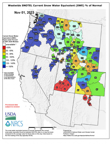
As of November 1, snow-water equivalent (SWE) conditions were mixed for the region, particularly in Utah with much-below normal SWE in the south and much-above normal SWE in the north. SWE was above normal in northern Utah, northern Wyoming, and the West Slope of Colorado, and below normal in southern Utah, southern Wyoming, and southwestern Colorado. In Colorado, most SNOTEL sites reported 1-2″ of SWE with a high of 2.8” in Schofield Pass near Maroon Bells. In Utah, most SNOTEL sites reported 0-1″ of SWE with a high of 1.4” at the Farmington site. Lastly, in Wyoming, most SNOTEL sites reported 1-4″ of SWE with a high of 4.1” at the Blackwater site near Yellowstone Lake.
Note: Current SWE as a percent of normal maps are often skewed at this time of year due to the very low average SWE this early in the season.
At the end of October, drought covered 11% of the region, a 3% increase from late September. Wyoming is no longer drought-free with D1 moderate drought development in Carbon and Sweetwater Counties. In Utah, there was a 1-category degradation in drought conditions in Uintah County. In Colorado, there was a mix of 1-category degradations in drought conditions in the Eastern Plains and the northwest and southwest, and 1-category improvements on the West Slope.
October streamflow conditions in the Upper Colorado River Basin were above normal in the Upper and Lower Green River Basin, near-normal in the White-Yampa River Basin, and below normal in the Colorado River Headwaters, Gunnison, Dolores, and San Juan River Basins. Most locations in the Utah portion of the Great Basin experienced normal to much-above normal streamflow conditions. Rivers in Wyoming also experienced normal to above normal streamflow conditions with much-above normal conditions in the Big Horn, Tongue, and Powder River Basins.
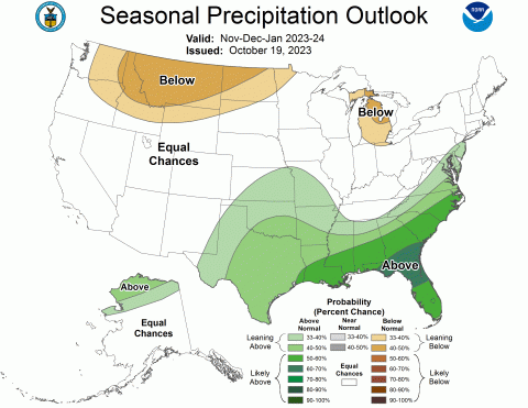
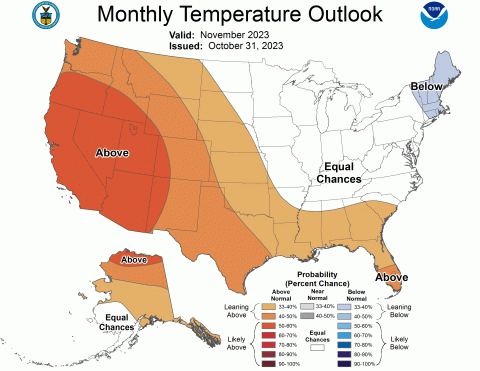
An El Niño advisory remained in place through October as above average sea-surface temperatures occurred across the equatorial Pacific Ocean and temperature anomalies increased in the central and east-central Pacific. El Niño conditions are projected to remain in place through late spring as there is greater than an 80% chance of El Niño conditions continuing through the March-May forecast period. The NOAA monthly temperature outlook for November suggests an increased probability of above average temperatures for the region, with a 40-50% chance of above normal conditions for the majority of Colorado and Wyoming and a 50-60% chance of above normal conditions for all of Utah. The NOAA seasonal precipitation outlook for November-January suggests below normal conditions for northern Wyoming and the seasonal temperature outlook for November-January suggests above normal conditions for northern and western Utah and the majority of Wyoming.
Significant October weather event. Halloween weekend snowstorm. From October 28-29, a stalled jet streak over Colorado coupled with the coldest air of the season caused scattered bands of heavy snow to develop throughout the state. Thanks to this storm, Denver received its first snowfall of the season, with up to 8” of snow. Many areas in the Denver metro area received more than 8” of snow, including Aurora at 10.4”, Englewood at 10.2”, and Cherry Creek Reservoir at 9.5”. Castle Rock received 12.5” of snow and Colorado Springs received 11”. Other locations receiving heavy snow included Eldora with 14”, Estes Park with 13”, and Evergreen with 11.5”. The heaviest snow totals were recorded in the central mountains, with a high of 24” just north of Crested Butte in Gothic. Crested Butte received 19″, Copper Mountain received 16.9”, Breckenridge received 16”, and Silverthorne received 15.6”.
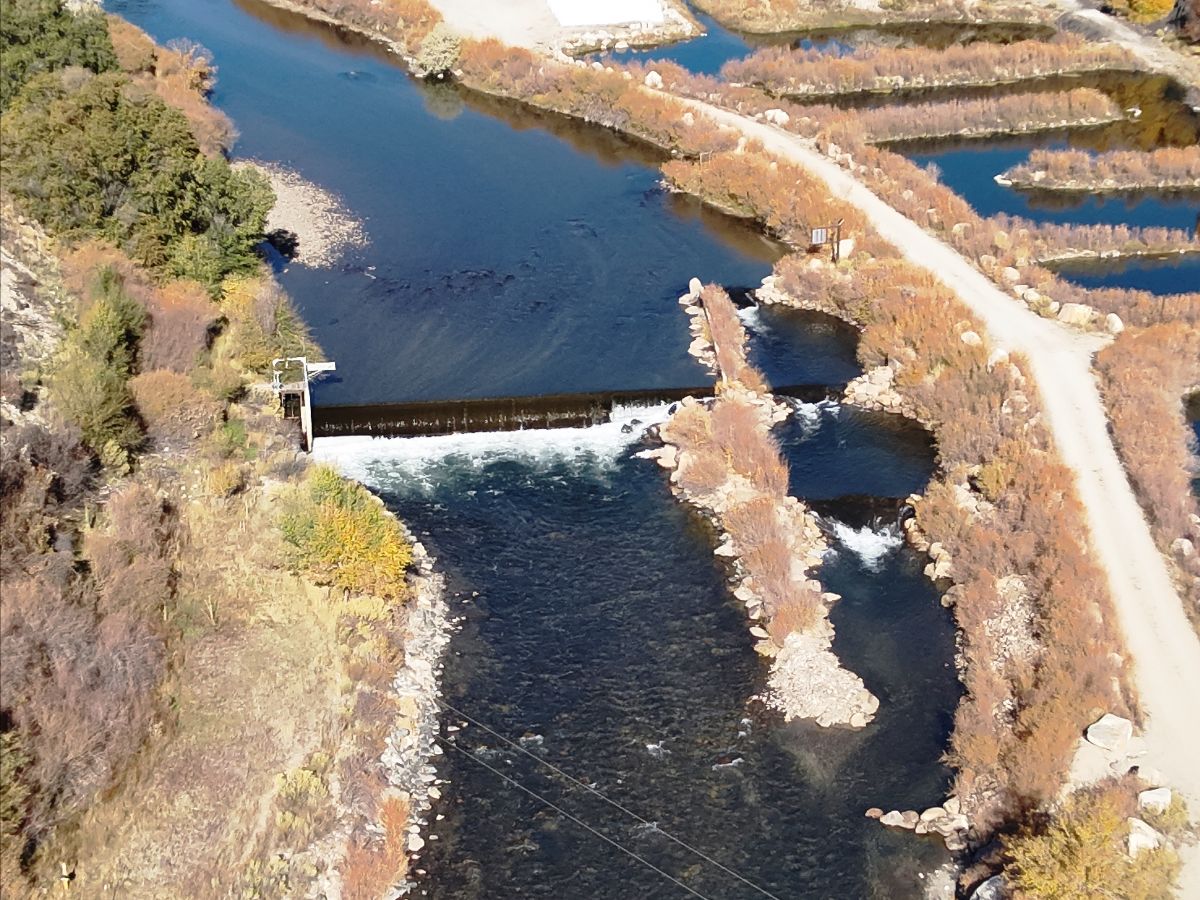
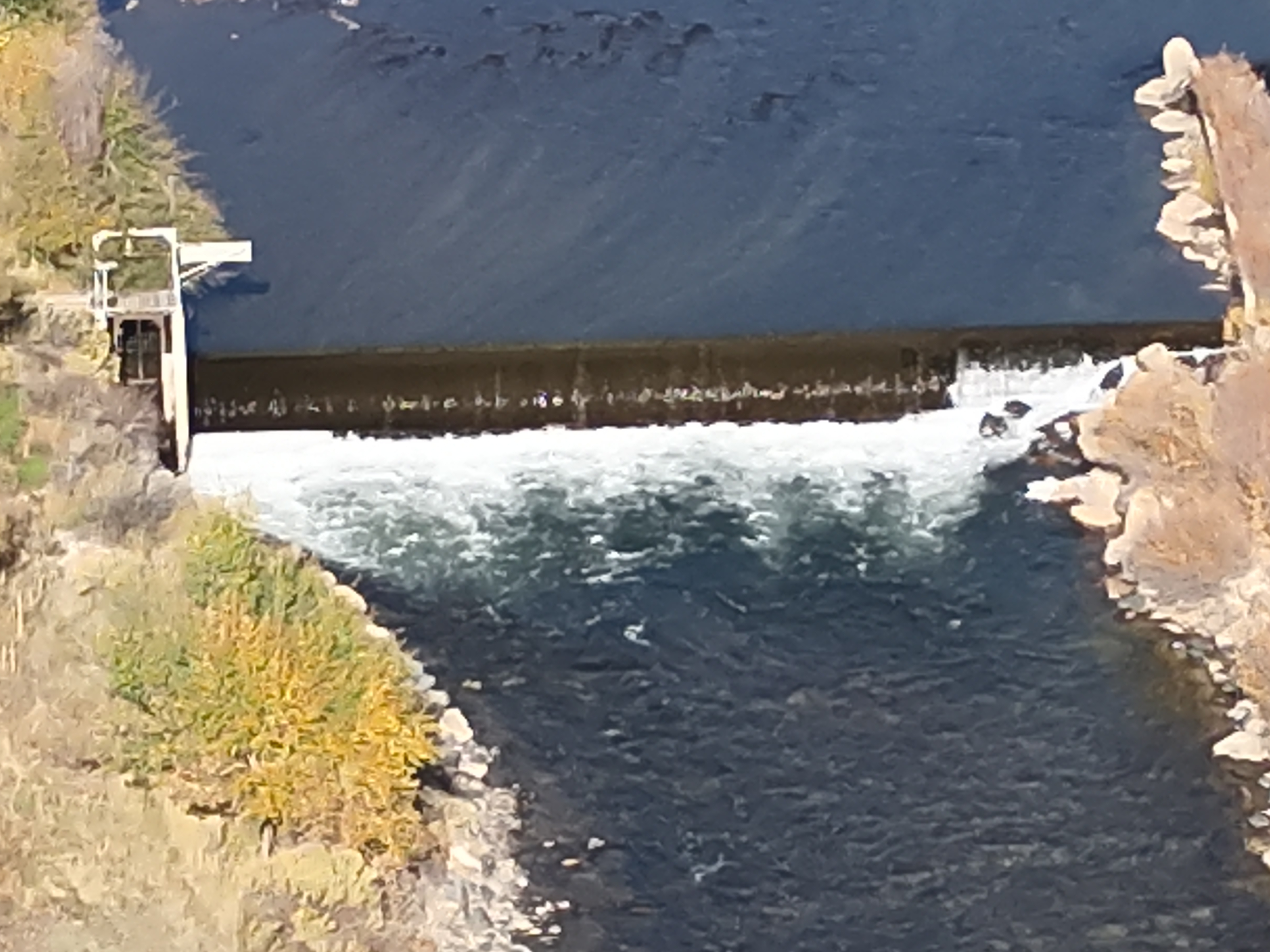
This low-head dam was built on the Arkansas River west of Salida in 1956 to provide water to hatcheries. It was rebuilt in 1988 with a boat chute, seen on the right, to provide a safe passage for watercraft. Still, the dam was a deadly hazard. Colorado Parks and Wildlife removed the dam with help from its partners the Chaffee County Board of County Commissioners. Photo courtesy of Colorado Parks and Wildlife.
Nov. 16, 2023 SALIDA, Colo. – Colorado Parks and Wildlife on Thursday lifted a closure of the Arkansas River above Salida that was imposed last month to allow removal of a low-head dam located 1.5 miles upstream from CPW’s Mount Shavano State Fish Hatchery.
The river was reopened as crews completed removal of the dam and an adjacent boat chute, said Tom Waters, CPW’s park manager for the Arkansas Headwaters Recreation Area, which encompasses 152 miles of the Arkansas River from Leadville to Pueblo.
“We are happy to announce the river is open again, weeks sooner than expected, to instream recreation,” Waters said. “The closure and mandatory portage signs have been removed and the buoy line barrier across the river has been taken down.”
Waters said final clean-up work along the banks should be done by Nov. 23.
CPW had closed the stretch of river from the Chaffee County Road 166 Bridge to the Salida Boat Ramp to allow heavy equipment to break up and remove the dam, which was first built around 1956 to collect water for the hatchery downstream. The dam was rebuilt in 1987 with an adjacent boat chute.
“By removing the dam, we have eliminated a deadly threat to the thousands who boat on this popular stretch of the Arkansas River each year,” Waters said. River water, spilling over the dam, churned at the bottom of the dam structure, creating a powerful hydraulic that capsized and trapped boaters and swimmers. Since 2010, three people have died at the dam.
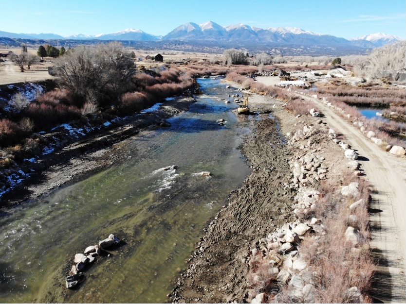
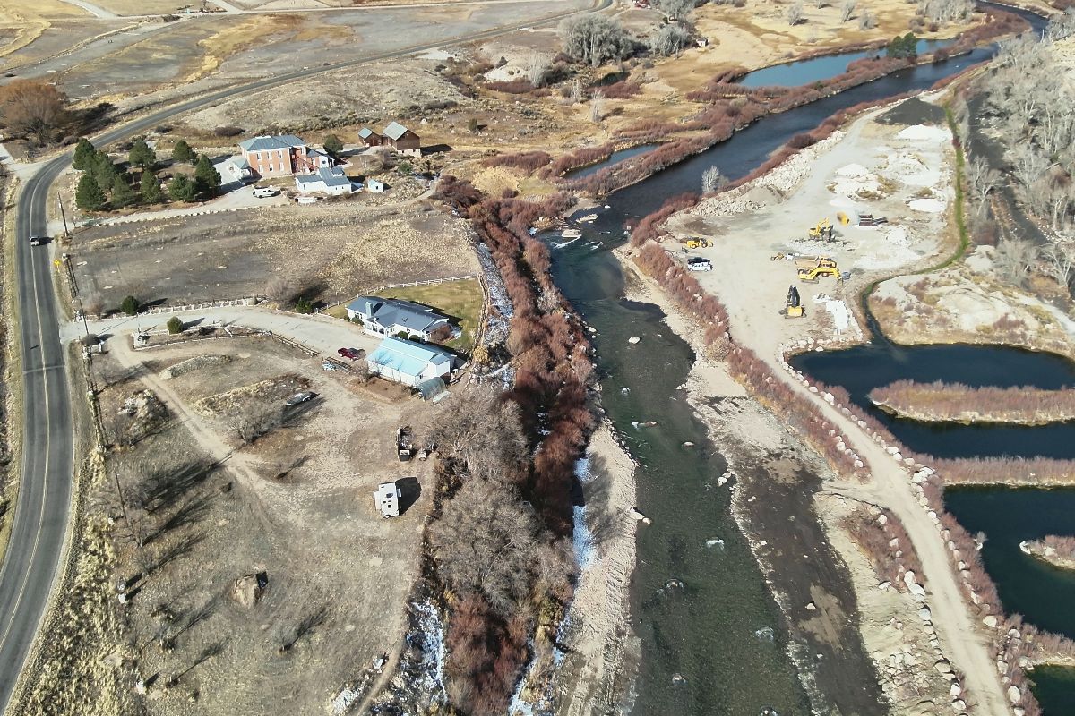
Removing the dam also enhances movements of fish – brown trout, rainbow trout and native white suckers – by easing migration access to about 85 miles of the Gold Medal river upstream. Barriers like the dam limit genetic diversity by essentially isolating segments of the river’s fish population.
The ability of fish to move freely in a river also helps to prevent overpopulation by balancing the amount of habitat and forage with the number of fish it can support.
“This project is a great example of how CPW works with its local partners to accomplish important projects for the public,” said April Estep, deputy regional manager of CPW’s Southeast Region. She specifically praised CPW’s partners, including the Chaffee County Board of County Commissioners, who provided $100,000 toward the $1.1 million removal effort.
The dam has not been used as a hatchery water supply since 2000 after whirling disease was detected in the river. Whirling disease is caused by a parasite that infects rainbow trout, leaving them deformed and swimming in circles before it quickly kills the youngest fish. CPW spent $1.5 million at the hatchery to convert it to clean spring water to raise its fish.
Photo shows the dam prior to the start of demolition in October. Photo credit: Colorado Parks & Wildlife
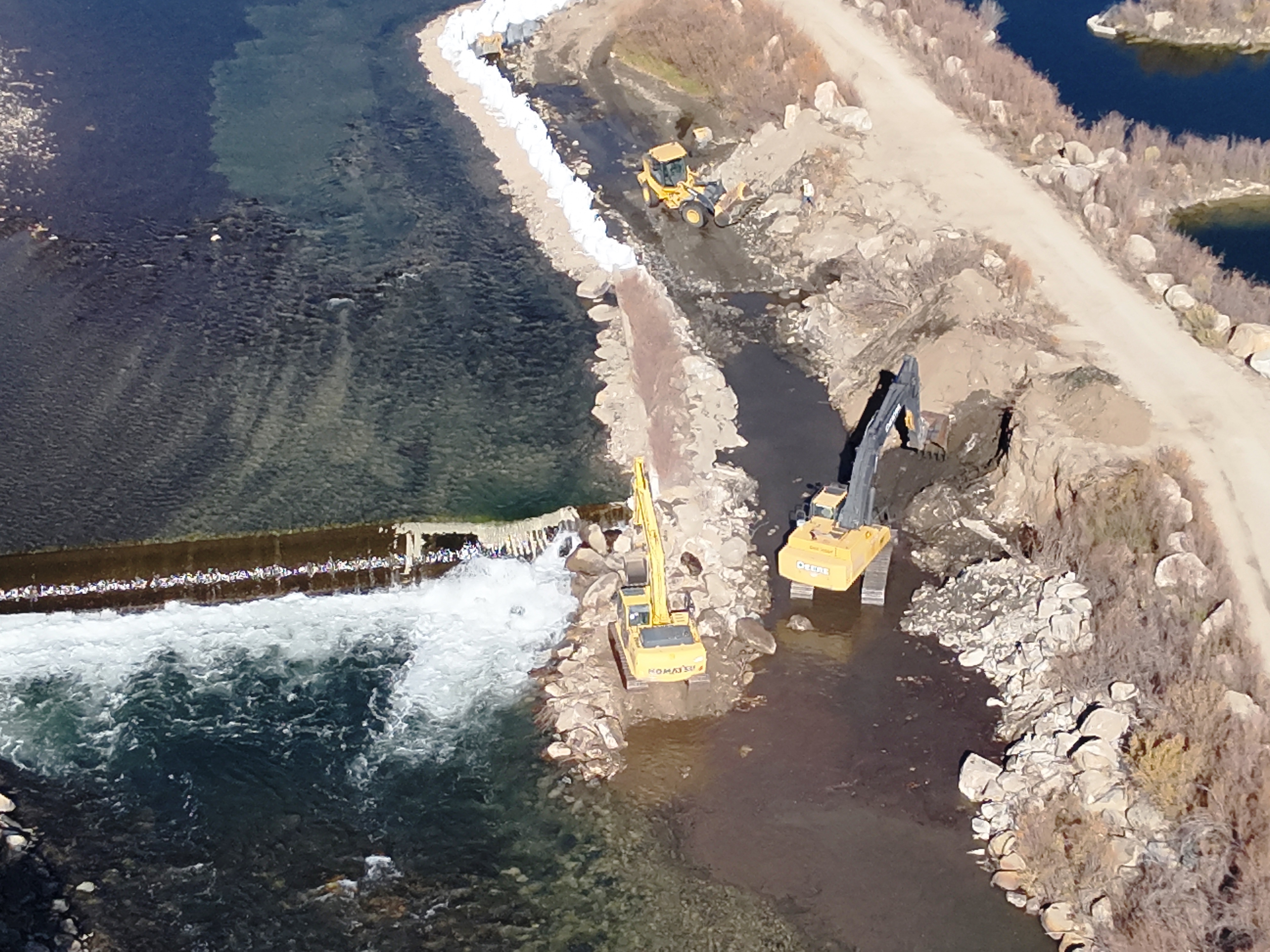
Then crews built a dam to channel the main flow of the river through the old chute so excavators could begin breaking up the dam. Photo credit: Colorado Parks & WildlifeCrews started by sealing off the boat chute and using excavators to remove the chute structure, creating a smooth river bottom so the Arkansas River could be diverted through it. Photo credit: Colorado Parks & WildlifeFinally, the dam was removed and rock structures were placed in the river channel to slow water flow and create fish habitat. The structures are visible from the aerial photos. Photo credit: Colorado Parks & WildlifeFinally, the dam was removed and rock structures were placed in the river channel to slow water flow and create fish habitat. The structures are visible from the aerial photos. Photo credit: Colorado Parks & WildlifeFinally, the dam was removed and rock structures were placed in the river channel to slow water flow and create fish habitat. The structures are visible from the aerial photos. Photo credit: Colorado Parks & Wildlife
Rio Grande at Albuquerque, November 2023. Photo credit: John Fleck
Click the link to read the article on the InkStain website (John Fleck):
Finishing the new book has thrown me into a time warp.
We’re about to hand in a manuscript for a book that traces a century and a half of the evolution of Albuquerque’s relationship with the Rio Grande, leading up to now. But the now of the act of writing (November 2023) is different from the now that will exist when the book first emerges in 2025, and the now in which readers experience it in the years that follow.
This conceptual muddle is crucial for the book. We are trying to describe the process of becoming that made Albuquerque what it is. That process of becoming, we argue at some length, cannot be understood without understanding how we as a community came together to act collectively to manage our relationship with the river that flows through our midst.
But – and this is the crucial thing, because it explains why we are writing this book – the process of becoming is never done. We hope to help inform Albuquerque’s discussion of what happens next.
There’s less water. What do we do? We will never stop negotiating our complex relationship as a community with the Rio Grande.
I spent a delightful afternoon yesterday that stretched well into the evening, listening to a series of enormously consequential discussions of these issues at the monthly meeting of the board of directors of the Middle Rio Grande Conservancy District. One of the district’s senior folks recently pointed out how often, during the most difficult of discussions, they look at me sitting in the audience and see me grinning. Those most difficult discussions are the most fascinating to me.
I found myself leaning forward in my chair frequently, shifting my position to see the faces of the board members and staff as they wrestled with this stuff.
I grinned a lot.
Three things from yesterday’s meeting stood out. All three are things that would have merited a significant newspaper story back in my Albuquerque Journal days. This blog post is not that, but if you’re paying attention to Middle Valley water you should keep an eye out for these three incredibly important developing issues.
1) NEW MEXICO’S RIO GRANDE COMPACT DEBT IS LIKELY TO RISE
The Rio Grande Compact, an agreement among Colorado, New Mexico, and Texas to share the waters of the compact’s eponymous river, has a tricky sliding formula determining how much water each state is allowed to consume (through human use as well as riparian evapotranspiration), and how much it must pass to its downstream neighbor. It’s got some wiggle room – states can run a debt, as long as it doesn’t get too large and they catch up in subsequent years. But the changing hydrology of the Middle Valley has made it increasingly difficult for New Mexico to meet its downstream delivery obligations.
New Mexico is currently 93,000 acre feet in debt because of under deliveries in recent years. The hole’s likely to get a lot deeper this year, thanks to a big spring runoff (which increases New Mexico’s required deliveries) and a lousy monsoon (good summer rains can help make up a deficit – this year they did not). If our debt rises above 200,000 acre feet, bad things happen.
El Vado Dam and Reservoir. Photo credit: USBR
2) EL VADO DAM RECONSTRUCTION IS TAKING A LOT LONGER THAN IT WAS SUPPOSED TO TAKE
El Vado Dam was built in the 1930s to store water for Middle Rio Grande Valley irrigators, allowing storage of spring runoff to stretch the growing season threw summer and into fall. But it’s kinda broken. Contractors working for the US Bureau of Reclamation began work a couple of years ago to fix it, with the expectation that it would take a couple of years. It is now widely understood that it may not be done and in operation again until 2027. Or later.
This would be devastating to the portion of irrigators in the Middle Rio Grande Valley that farm for a living. As our book will deeply argue, it’s critical to understand that this represents a minority of irrigated land in the valley. Much of the farming here is non-commercial, “custom and culture” farming, a supplemental income (or even, for the affluent, a delightful money loser) for people whose livelihood doesn’t depend on it. But for either class of irrigators, a lack of late summer and fall water makes things incredibly hard.
El Vado’s problems have not been publicly announced yet, but all the cool kids are talking about them. Expect something more substantive at December’s MRGCD board meeting.
Side channels were excavated by the Bureau of Reclamation along the Rio Grande where it passes through the Rhodes’ property to provide habitat for the endangered silvery minnow. (Dustin Armstrong/U.S. Bureau Of Reclamation)
3) FALLOWING
We could see a substantial expansion of acreage fallowed, with a big chunk of federal money paid to irrigators to forego their water in the next few years. MRGCD has been building the institutional widget to do this for several years, with federal money flowing to irrigators to lay off watering their land for either a partial or full season as part of a federally funded program to generate water to meet Endangered Species Act requirements for our beloved Rio Grande silvery minnow. In 2023, that generated (in accounting terms, be skeptical of the four-digit precision) 3,615 acre feet of water.
For 2024, the MRGCD, working with federal money funneled through the state, will push for a dramatic increase. Price per acre will double, to $400 an acre for a split season (irrigate in spring and fall, but not in summer when demand is highest) and $700 an acre for a full season. It’s a voluntary program, so all depends on how much irrigators want to join in, but I can imagine a lot of people looking at the El Vado shitshow and taking the money.
There was a very confusing board discussion that involved an actual invocation of Roberts Rules of Order by the district’s legal counsel and a vote that I still don’t understand with people who support the program voting “no” and people who oppose it (I think) voting “yes”. If I was still a reporter I would have had to sort all of this out while an editor hovered barking about deadlines, but thankfully it’s just a blog that no one actually reads, written by an old guy in pajamas still working on his morning coffee and breakfast.
The bottom line is the possibility of the compensated fallowing of as much as 8,000 acres next year, ~15-ish percent of all irrigated land. I think. As I said it was a pretty confusing thing, and I’m not done with breakfast.
The Rio Grande Basin spans Colorado, New Mexico and Texas. Credit: Chas Chamberlin
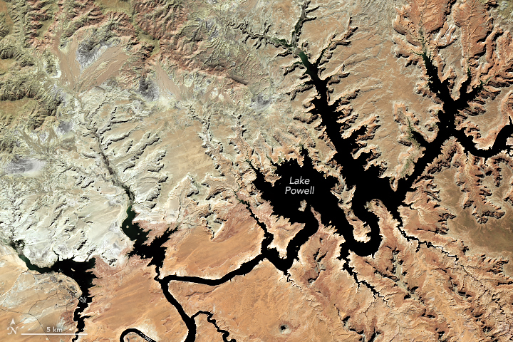
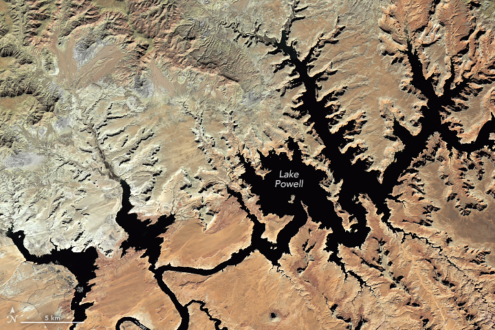
Lake Powell September 23, 2022. Photo credit: NASA
Lake Powell October 30, 2023. Photo credit: NASA
Click the link to read the article on the NASA website:
A wet winter in western states provided a short-term reprieve to the decades-long drought in the reservoir.
After falling to record lows in early 2023, water levels in Lake Powell—the second-largest reservoir in the United States—rebounded in the summer of 2023. Above-average snowmelt from the Rocky Mountains provided some short-term relief to the reservoir, but long-term drought remains.
The images above show portions of Lake Powell, which straddles the border of Utah and Arizona, as of October 20, 2023 (right), compared to September 23, 2022 (left). As of November 12, 2023, lake levels stood at 3,572 feet (37 percent full), which is just below the 1991–2020 average for that date. The 2023 image was acquired with the OLI (Operational Land Imager) on Landsat 8 and the 2022 image was acquired by the OLI-2 on Landsat 9.
The Colorado River feeds Lake Powell and Lake Mead farther downstream. Most of the river basin is arid or semi-arid and generally receives less than 10 inches (25 centimeters) of precipitation per year. Managed by the U.S. Bureau of Reclamation (USBR) and other agencies, the river provides water and electric power to roughly 40 million people—most notably the cities of Las Vegas, Phoenix, Los Angeles, and San Diego—and water to 4 to 5 million acres of farmland in the Southwest.
A series of nine atmospheric rivers brought significant amounts of rain and snow to the western U.S. in December 2022 and January 2023. But much of the precipitation in the Colorado River Basin stayed frozen at high elevations of the Rocky Mountains, preventing it from entering Lake Powell. On April 13, water in the lake fell just below 3,520 feet, its lowest level since the reservoir was filled in 1980.
As temperatures increased in spring and summer, above-average runoff from the Rockies provided a much-needed reprieve. The amount of water held in the reservoir rose from 22 percent full in April to about 40 percent full in early July.
Water levels Lake Powell 1980 – 2023. Image credit: NASA
But it will take much more than one wet year to refill the reservoir to “full pool” (elevation 3,700 feet). Two decades of drought in the American Southwest have drawn down water in the reservoir. Water levels in Lake Powell fell to a record low in 2022 and again in 2023.
In April 2023, USBR released a draft Environmental Impact Statement for Colorado River Operations, which assessed the chances of the reservoir falling below the critical elevation of 3,490 feet. This elevation, known as the “minimum power pool,” is the level below which water can no longer flow through the intake valves in the dam to generate hydroelectric power. USBR warned that water levels had a 57 percent chance of dropping to below the minimum power pool before 2026. But because of above-average runoff in the spring and summer, USBR revised these estimates in October 2023. They found that the chance of the reservoir dipping to this elevation through 2026 had fallen to 8 percent.
The impact statement noted that although there is year-to-year variation in flow in the Colorado River and its tributaries, the basin is still in a prolonged period of aridification caused by climate change. Drought and low runoff from 2000 to 2022 have led to “the driest 23-year period in more than a century and one of the driest periods in the last 1,200 years.”
“New plot using the nClimGrid data, which is a better source than PRISM for long-term trends. Of course, the combined reservoir contents increase from last year, but the increase is less than 2011 and looks puny compared to the ‘hole’ in the reservoirs. The blue Loess lines subtly change. Last year those lines ended pointing downwards. This year they end flat-ish. 2023 temps were still above the 20th century average, although close. Another interesting aspect is that the 20C Mean and 21C Mean lines on the individual plots really don’t change much. Finally, the 2023 Natural Flows are almost exactly equal to 2019. (17.678 maf vs 17.672 maf). For all the hoopla about how this was record-setting year, the fact is that this year was significantly less than 2011 (20.159 maf) and no different than 2019” — Brad Udall