
Click the link to read the summary on the Western Water Assessment website:
Latest Briefing
Water Year 2023 Summary
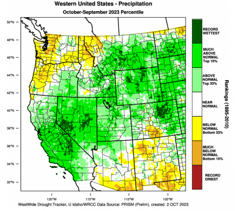
The 2023 water year began with nearly two-thirds of the Intermountain West in drought. Much-above average precipitation fell across nearly the entire region during winter and many long-term monitoring sites in Utah and western Colorado broke snow-water equivalent (SWE) records. Above average winter precipitation and snowfall caused above-to-much-above average seasonal streamflow volumes across nearly the entire region. Wet winter conditions alleviated drought in many locations. An active North American monsoon season caused areas of above average precipitation in late summer and fall which alleviated drought conditions in all but 8% of the region.
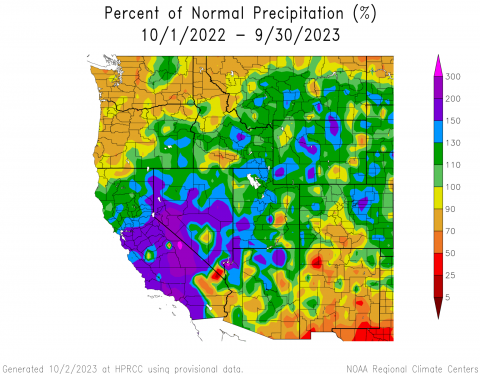
Precipitation during the 2023 water year was above normal to much-above normal for much of the region, except for a large region of south-central Colorado and pockets of eastern Utah and eastern Wyoming where precipitation was 50-90% of normal. Much-above normal conditions of up to 200% occurred in pockets of western and northern Wyoming, east of the Denver area in Colorado, and southwestern Utah. Record wet conditions occurred in much of northeastern Colorado, particularly along the Front Range and counties surrounding Denver, regions of northern Wyoming from Park and Hot Springs to Sheridan, Johnson, and Crook Counties, and southeastern Wyoming near Cheyenne and Laramie.
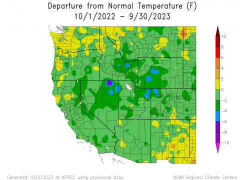
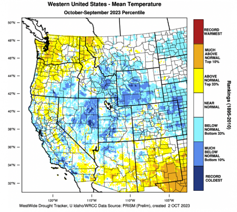
Temperatures during the 2023 water year were below normal for the region, besides small pockets of slightly-above normal temperatures in each state, particularly in the San Luis Valley region of Colorado. Temperatures ranged from near-normal to -6°F below normal throughout the region, with the coldest temperatures from normal observed in northwestern Colorado, northwestern and northeastern Utah, and western Wyoming. Based on mean temperature data from 1895-2010, the region experienced much-below normal temperatures, particularly in southwestern Utah, western and central Wyoming, and eastern Colorado. Record cold temperatures were observed in small pockets of southwestern Utah and Fremont County in Wyoming.
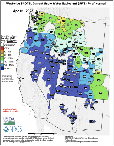
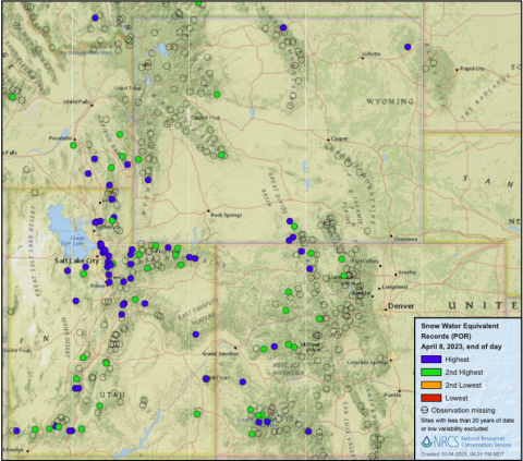
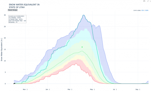
April 1st snow-water equivalent was above average to much-above average for nearly all river basins in Colorado, Utah, and Wyoming. Many river basins and individual SNOTEL sites received record SWE accumulation during the 2023 water year; as a statewide average Utah received record SWE accumulation in 2023, breaking the previous record set in 1983. The largest snowpacks were found in Utah and western Colorado including record SWE accumulation in the Lower Bear, Dolores, Lower Green, Jordan, Lower San Juan, and Weber River Basins.
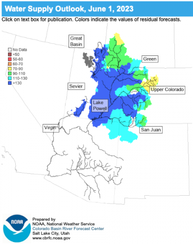
Seasonal runoff volume was above-to-much-above average for all regional river basins except for the Arkansas River Basin where spring runoff volume was slightly-below average. Seasonal runoff volume for the Upper Colorado River Basin was 157% of average. Seasonal streamflow volumes were highest in Utah and western Colorado and lowest in the Arkansas and South Platte River Basins.

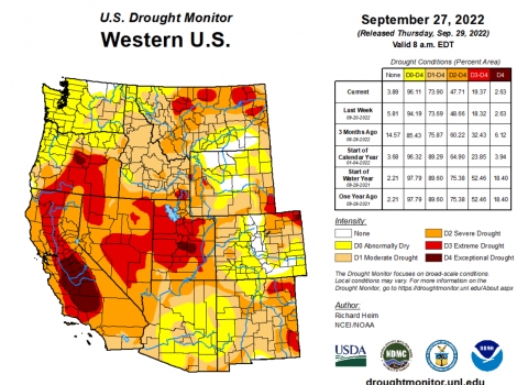
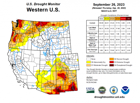
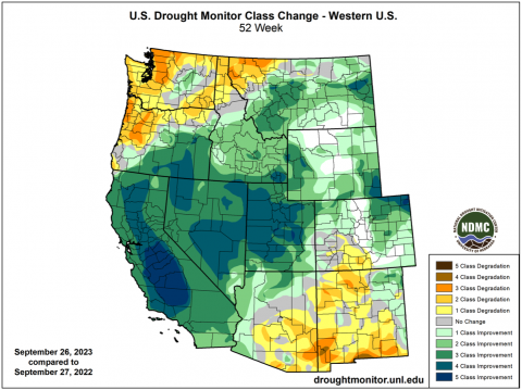
Drought was removed from nearly all of the Intermountain West during the 2023 water year. In late September 2022, drought covered 64% of the region. By late September 2023, only 8% of the region was in drought. In Utah, where D3-D4 (extreme to exceptional) drought covered nearly 60% of the state at the start of the water year, extremely high winter precipitation and an active monsoon in August-September caused statewide drought coverage to fall to 5% by September 2023. A portion of northwest Wyoming remained in drought after winter 2023, but a wet August completely removed drought from Wyoming. In Colorado, deep winter snowpacks aided the removal of drought conditions only to see drought return by August. Finally, drought conditions on Colorado’s Eastern Plains were completely removed after very wet conditions in May and June.
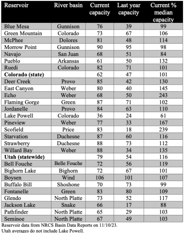
Reservoir storage conditions improved significantly across the entire region except for Lake Powell which saw a more modest improvement of conditions. Reservoir storage is average to above average for nearly every major reservoir in the region. The huge 2023 snowpack brought much above average runoff volume into Lake Powell. By July 2023, Lake Powell rose 60 feet increasing from 24% to 36% of capacity by the end of the 2023 water year.
November 10, 2023 – CO, UT, WY
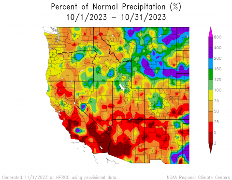
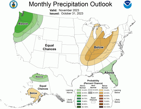
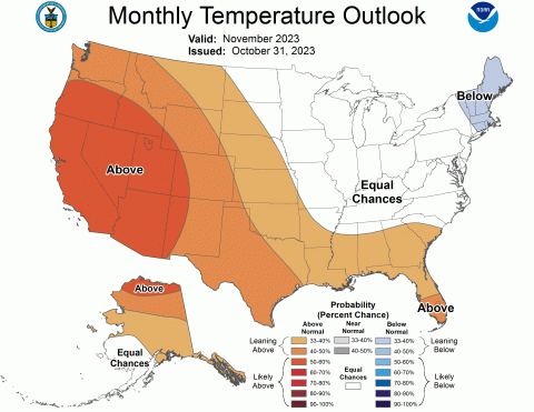
October precipitation varied throughout the region, generally with above normal conditions in Wyoming and below normal conditions in Colorado and Utah. October temperatures were near-normal across the region, leaning towards the warmer side overall. Regional snow-water equivalent (SWE) was mixed, with the greatest variance of much-above to much-below normal SWE in Utah. Drought conditions slightly expanded during October and at the end of the month, drought covered 11% of the region. El Niño conditions persisted during October and are expected to remain through late spring. NOAA seasonal forecasts for November suggest an increased probability of above normal temperatures and equal chances for precipitation for the region.
Regional precipitation during October was a mix of conditions, including much-above normal conditions in Wyoming and much-below normal conditions in Colorado and Utah. Greater than 200% of average precipitation was observed in large regions of Wyoming, including Park, Hot Springs, and Fremont Counties in the west and Johnson, Converse, and Niobrara Counties in the east, as well as Baca County in southeastern Colorado. Less than 25% of average precipitation was observed in pockets throughout the region, mainly in southern Utah and southeastern Colorado where pockets of less than 2% of average precipitation were observed. Above and below normal conditions were observed throughout the region, with Wyoming seeing more above normal conditions and Colorado and Utah seeing more below normal conditions overall.
Regional temperatures were near-normal (+/- 3°F of average), mainly leaning slightly-above normal throughout. Many pockets of above normal temperatures (+ 3-6°F of average) were scattered throughout the region, particularly in Colorado and Utah. There was one anomalous pocket of much-below normal temperatures in Duchesne and Summit Counties in Utah, ranging from -9 to -15°F of average and below.

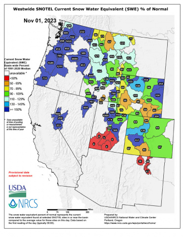
As of November 1, snow-water equivalent (SWE) conditions were mixed for the region, particularly in Utah with much-below normal SWE in the south and much-above normal SWE in the north. SWE was above normal in northern Utah, northern Wyoming, and the West Slope of Colorado, and below normal in southern Utah, southern Wyoming, and southwestern Colorado. In Colorado, most SNOTEL sites reported 1-2″ of SWE with a high of 2.8” in Schofield Pass near Maroon Bells. In Utah, most SNOTEL sites reported 0-1″ of SWE with a high of 1.4” at the Farmington site. Lastly, in Wyoming, most SNOTEL sites reported 1-4″ of SWE with a high of 4.1” at the Blackwater site near Yellowstone Lake.
Note: Current SWE as a percent of normal maps are often skewed at this time of year due to the very low average SWE this early in the season.
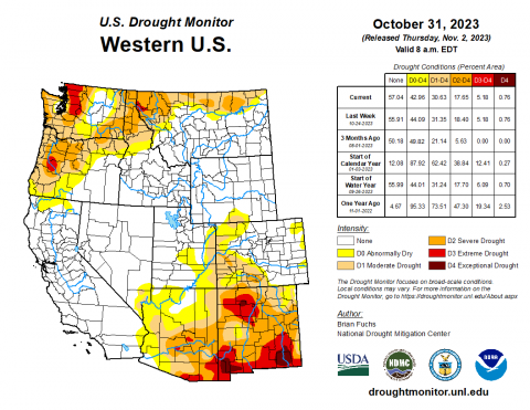
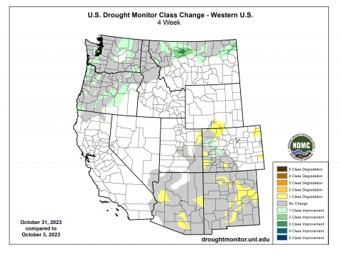
At the end of October, drought covered 11% of the region, a 3% increase from late September. Wyoming is no longer drought-free with D1 moderate drought development in Carbon and Sweetwater Counties. In Utah, there was a 1-category degradation in drought conditions in Uintah County. In Colorado, there was a mix of 1-category degradations in drought conditions in the Eastern Plains and the northwest and southwest, and 1-category improvements on the West Slope.
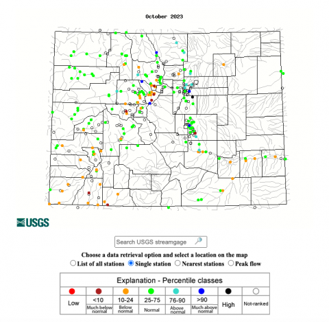
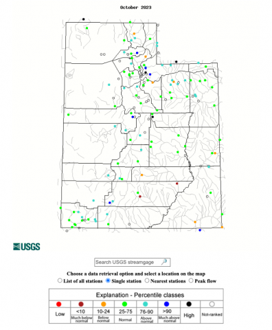
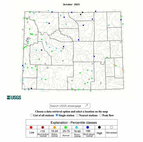
October streamflow conditions in the Upper Colorado River Basin were above normal in the Upper and Lower Green River Basin, near-normal in the White-Yampa River Basin, and below normal in the Colorado River Headwaters, Gunnison, Dolores, and San Juan River Basins. Most locations in the Utah portion of the Great Basin experienced normal to much-above normal streamflow conditions. Rivers in Wyoming also experienced normal to above normal streamflow conditions with much-above normal conditions in the Big Horn, Tongue, and Powder River Basins.
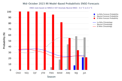
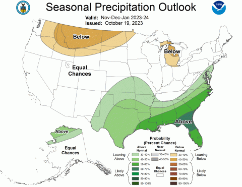
An El Niño advisory remained in place through October as above average sea-surface temperatures occurred across the equatorial Pacific Ocean and temperature anomalies increased in the central and east-central Pacific. El Niño conditions are projected to remain in place through late spring as there is greater than an 80% chance of El Niño conditions continuing through the March-May forecast period. The NOAA monthly temperature outlook for November suggests an increased probability of above average temperatures for the region, with a 40-50% chance of above normal conditions for the majority of Colorado and Wyoming and a 50-60% chance of above normal conditions for all of Utah. The NOAA seasonal precipitation outlook for November-January suggests below normal conditions for northern Wyoming and the seasonal temperature outlook for November-January suggests above normal conditions for northern and western Utah and the majority of Wyoming.

Significant October weather event. Halloween weekend snowstorm. From October 28-29, a stalled jet streak over Colorado coupled with the coldest air of the season caused scattered bands of heavy snow to develop throughout the state. Thanks to this storm, Denver received its first snowfall of the season, with up to 8” of snow. Many areas in the Denver metro area received more than 8” of snow, including Aurora at 10.4”, Englewood at 10.2”, and Cherry Creek Reservoir at 9.5”. Castle Rock received 12.5” of snow and Colorado Springs received 11”. Other locations receiving heavy snow included Eldora with 14”, Estes Park with 13”, and Evergreen with 11.5”. The heaviest snow totals were recorded in the central mountains, with a high of 24” just north of Crested Butte in Gothic. Crested Butte received 19″, Copper Mountain received 16.9”, Breckenridge received 16”, and Silverthorne received 15.6”.