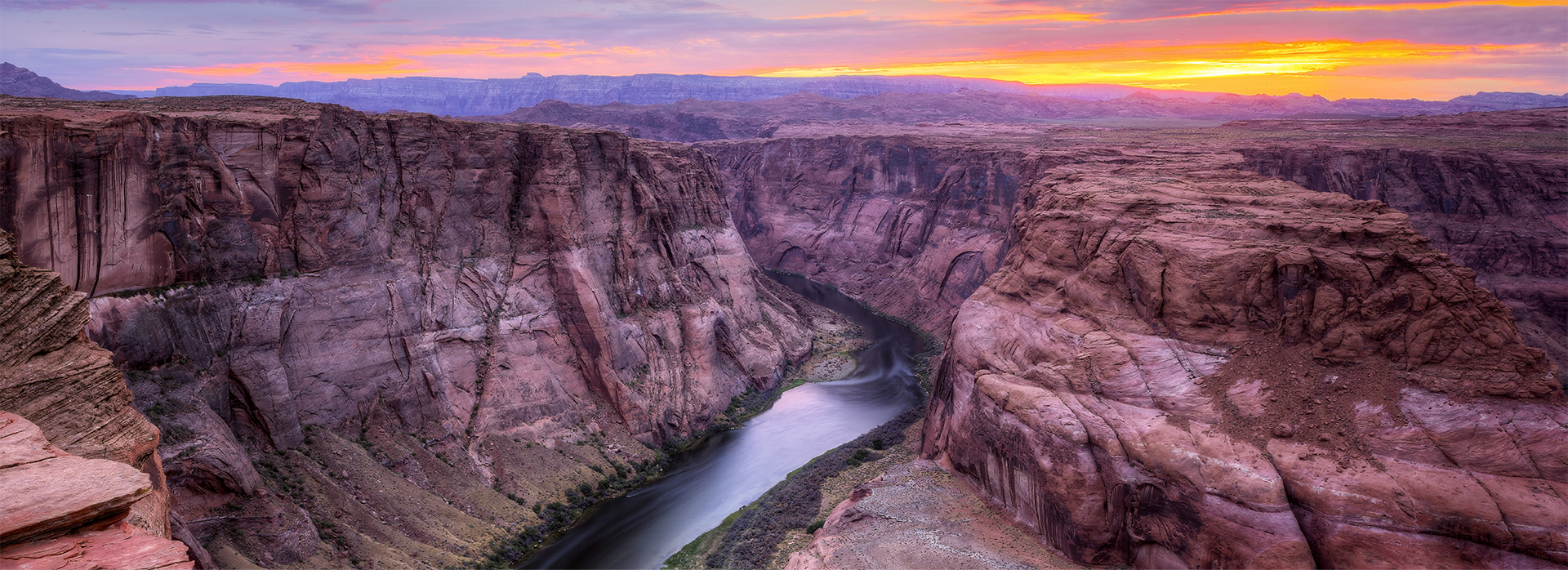
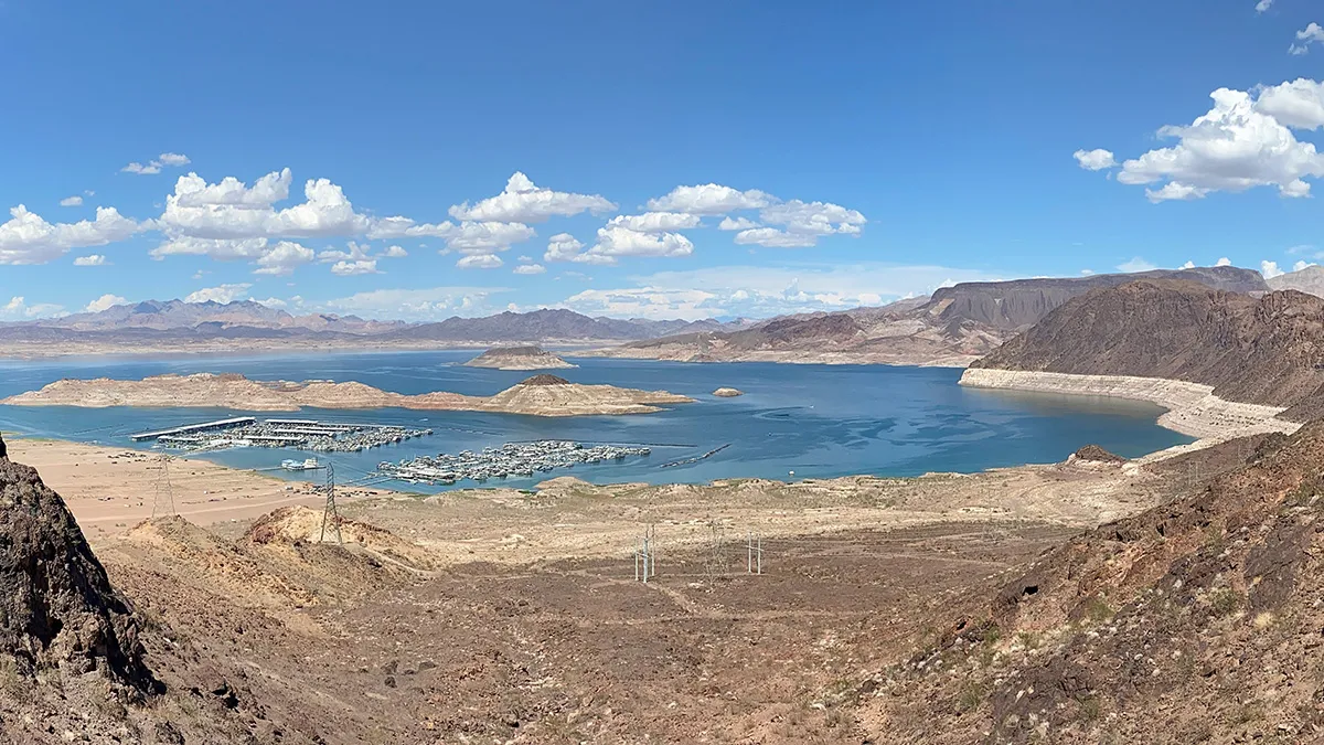
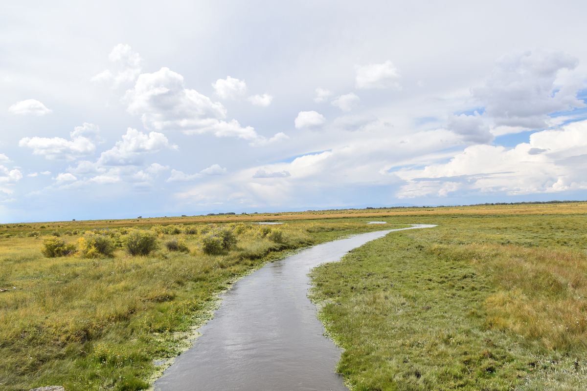
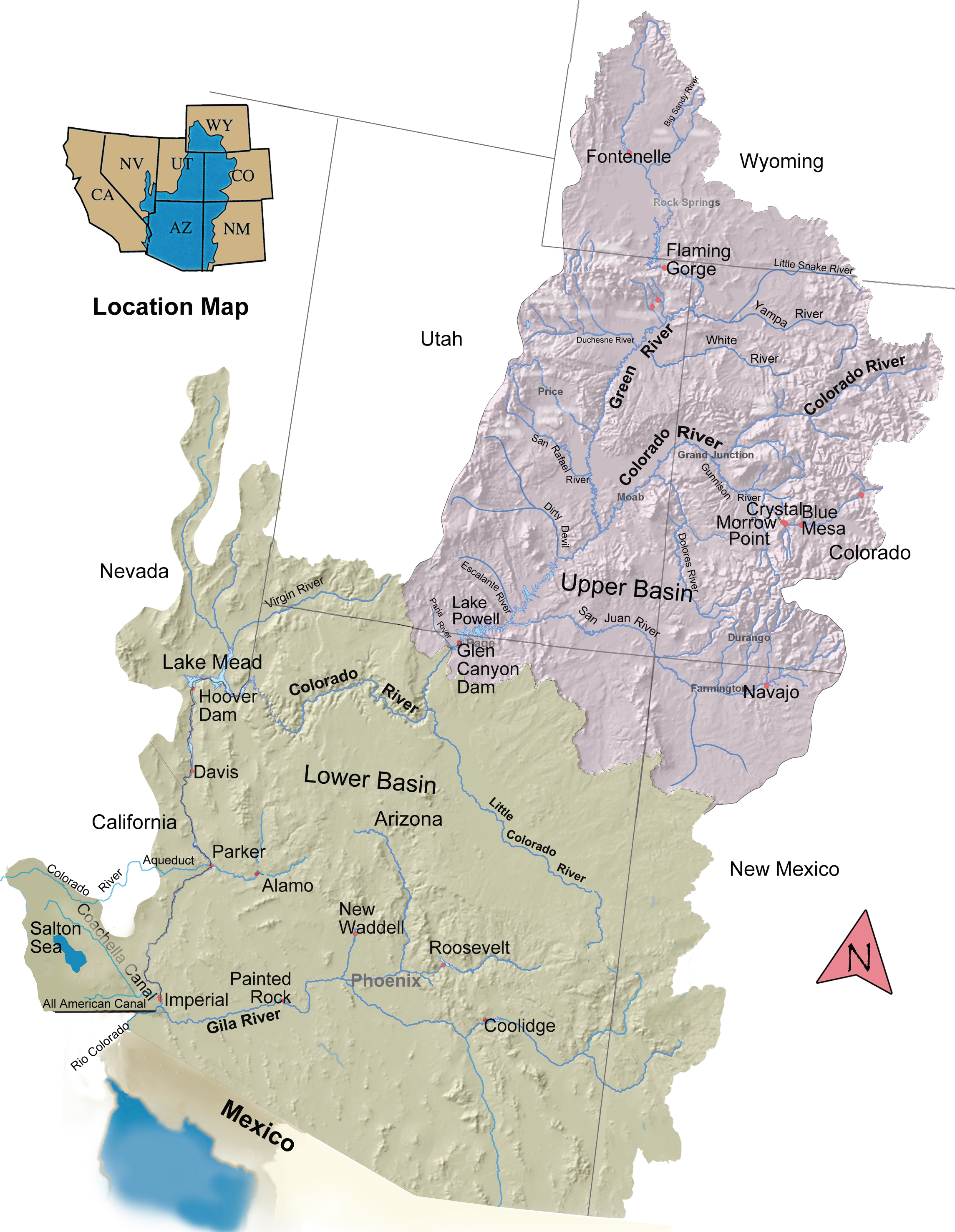
This project explores the complex challenges facing the Colorado River basin through a visual journey using photography, informative graphics and maps. The exploration includes voices from often-overlooked Native tribes with deep connections to the basin’s water and traverses all seven basin states, extending southward to the Gulf of California in Mexico.
Water management in the seven Colorado River Basin states and Mexico are intertwined, yet each faces unique circumstances and challenges.
PAWSD Business Manager Aaron Burns opened the discussion by ex- plaining that the board gave direction at its Nov. 14 work session for staff to look at other rates and fees beyond the district’s main water and waste- water rates, and attempt to use these to reduce the increases in water and wastewater rates. He stated that some of the areas discussed were availability fees, rates for waste haulers and rates at water fill stations. He added that staff from Stantec — the company performing the rate study for the district — incorporated the changes into the calculations, which made a “significant” differ- ence, particularly in wastewater rate increases.
Zac Koch of Stantec then presented on the rate study, highlighting the changes made from the previous presentation in November. For water rates, Koch explained that the primary change in the study was that, as suggested at the November work session, availability fees will now scale in accordance with the increases in water rates, with the expected decrease in the number of lots remaining the same…[Koch] stated that rate increases would remain at 5 percent annually between 2026 and 2029, with 15 percent increases occurring in 2030 and 2031 to cover the increased expenses for Regulation 35 compliance, and no increase in 2032. According to Koch’s presentation, this would bring the projected monthly residential bill from $32.80 in 2023 to $89.11 in 2032, down from the $103.34 bill in 2032 indicated in the previous presentation…
Following a brief discussion, the board unanimously voted to accept the conclusions of the rate study and to set a public hearing on the rates for Jan. 25, 2024, at 5 p.m. at the PAWSD administrative offices at 100 Lyn Ave.
Click the link to read the article on the Pagosa Springs Sun website (Derek Kutzer). Here’s an excerpt:
At a Dec. 21 meeting, the Pagosa Springs Town Council voted to change the language of an amend- ment to its tap agreement with The Springs Resort and Spa. Since 2009, the agreement has provided a certain amount of “raw geothermal water” to The Springs Resort for commercial uses. The town currently obtains water rights to two geothermal wells down- town. The new language adopted by the council will leave open the possibility of raising the rate that the town charges The Springs Resort for municipal geothermal water to even higher than the $12,000 per-year rate in the current drafted amendment.
At the meeting, Town Manager David Harris said, “The existing rates are set to expire in this calendar year,” which prompted the town and The Springs Resort to draft this amendment for the council to consider.
Harris explained that this new amendment was the product of discussions with the owners of The Springs and that both parties believe it is a “fair” agreement.
A below-average runoff this year could mean that reservoirs in Colorado and Wyoming would have to release water downstream to keep the lake from hitting levels that would threaten the Glen Canyon Dam’s energy generation and make delivering water to Arizona, California and Nevada nearly impossible. Colorado River water managers have implemented similar emergency measures in recent years to keep Lake Powell from reaching crisis levels. Utah reaches its typical peak snowpack in early April, and the state gets about 95% of its water supply from snow.
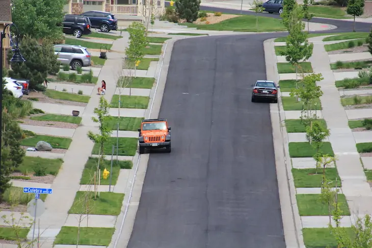
A proposed state law would take aim at thirsty turf varieties planted along streets and roads in new developments. This housing project, Leyden Rock in Arvada, has less space devoted to front-yard turf than many older subdivisions. CREDIT: ALLEN BEST/BIG PIVOTS
The deepening troubles of the Colorado River, a significant source of water for most of Colorado’s 5.9 million residents, has implications for the types of grasses we grow in our yards and in street medians.
Speaking in Las Vegas recently, former Arizona Gov. and former U.S. Interior Secretary Bruce Babbitt recalled warnings of worsening drought and imbalances between supplies and demand. “There’s going to be a day of reckoning,” Babbitt, 85, told Politico’s E&E News, referring to the warnings of scientists during past decades. “Here we are. The crisis has arrived.”
Colorado’s mounting efforts to limit new expanses of thirsty turf won’t solve the Colorado River problems. Colorado is just one of seven states in the basin. And even within Colorado, agriculture consumes roughly 90% of Colorado’s water and cities about 7%. Exterior use, such as for watering thirsty Kentucky bluegrass yards, consumes 40% to 60% of municipal water.
But if this water use is on the margins, it’s one that many water managers believe must be addressed. A bill that originated in the Water Resources and Agriculture Review Committee in October has the support of two of the state’s largest cities and has sponsors from both political parties from across Colorado.
This proposal would preclude the installation of nonfunctional turf as well as artificial turf in commercial, institutional or industrial properties or in transportation corridors, such as along streets or in road medians. Nonfunctional turf is defined as grasses that are predominantly ornamental — and that few will ever walk on unless to mow, yet still require heavy watering. Think, for example, of those giant carpets of green grass that commonly surround business parks such as the Denver Tech Center or Broomfield’s Inverness business park.
The bill, however, does not address residential water use.
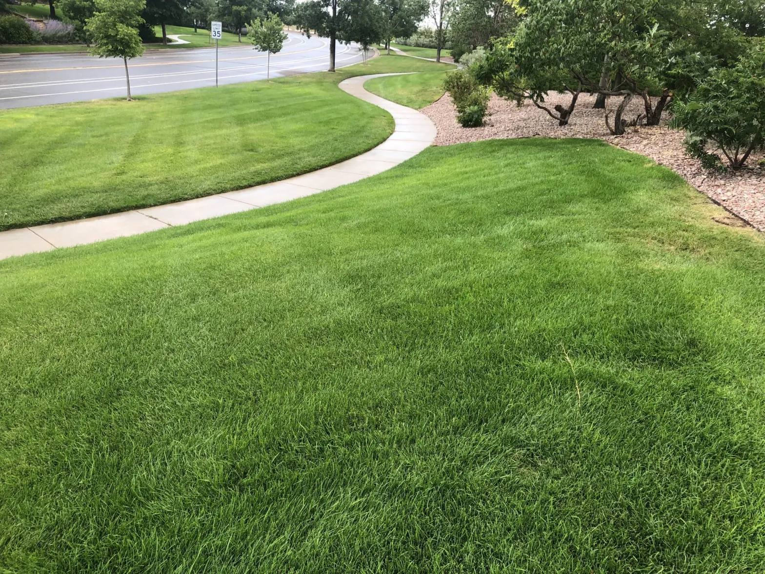
Many urban landscapes in Colorado are planted in Kentucky bluegrass and other thirsty species that require close to double what the semiarid climate delivers. Native grasses such as blue gramma and even some imported species can survive with far less or even no supplemental water.
Continued population growth also adds pressure to city water utilities. The Colorado Water Plan projects growth of the state’s current population to at least 7.7 million by 2050, mostly along the Front Range.
Legislators have been advised by the state’s Colorado River Drought Task Force to bump funding to $5 million per year for turf removal. In 2022, they allocated $2 million, which has now been exhausted in grants to local jurisdictions.
Also informing Colorado’s path forward will be recommendations from another task force, appointed by Gov. Jared Polis last January, to investigate opportunities for an accelerated transformation in use of water in urban landscapes. The 21 committee members were drawn from the ranks of local governments, academia, environmental advocacy groups and developers.
At their eight meetings, committee members wrestled with what should be the proper mix of incentives and mandates and ultimately just how far the state should push into matters of local land use. One member suggested that banning new turf in road medians was a no-brainer. Another member urged flexibility for local jurisdictions to achieve state goals. “We’re going to be on this journey for a long time,” said Catherine Moravec of Colorado Springs Utilities. “Less controversy will help keep us together.”
In final meetings, now concluded, members agreed on the need to support state legislation. The Colorado Water Conservation Board, which oversaw the process, emphasizes that the task force’s report will have no direct connection to legislation. The task force’s pending report “may be used by decision-makers at state, local or even neighborhood scales,” said Jenna Battson, the agency’s outdoor water conservation coordinator. “It’s a resource.” The task force recommendations are expected to be released in late January after review – and perhaps tweaking – by Polis.
Northern Water maintains a demonstration garden at its headquarters in Berthoud that illustrates various landscaping alternatives.
CREDIT: ALLEN BEST/BIG PIVOTS
Changing the status quo
Water scarcity underlies all these discussions. Specific circumstances vary. Some jurisdictions, most notably those between Denver and Colorado Springs, depend upon receding underground aquifers for most of their water. They get very little or no Colorado River water.
Most other jurisdictions do rely upon the Colorado River. Ambiguity has long dogged the Colorado River Compact, the agreement reached by delegates from the seven basin states in 1922. What if runoff declined substantially? The river since 2000 has delivered an average 12.3 million acre-feet per year, far short of the 20 million acre-feet that delegates had assumed.
Must Colorado and the three other upper-basin states — New Mexico, Utah and Wyoming — leave more water to flow downstream if runoff declines even more? That would cause curtailment of diversions with water rights after 1922. A study commissioned by the Glenwood Springs-based Colorado River Water Conservation District found that 96% of Front Range water use could be subject to curtailment.
That includes diversions by Denver Water. “It is possible that Denver Water’s deliveries of Colorado River basin supplies could be curtailed for a period of time,” advised a statement from Denver Water issued in August 2022 when the utility was issuing new water bonds.
That statement was issued the same month that Denver Water and 30 other utilities from Colorado to California that rely upon Colorado River Basin water committed to removing urban turf, with a goal of 75 million square feet in the case of Denver Water. That’s an area roughly equivalent in size to 1,800 football fields. At the current rate, that will be achieved in 100 years, according to Denver Water.
Even so, that was a sharp reversal for Denver Water, a utility that delivers water to 1.5 million people in Denver and 17 other municipalities in the metro area. Even after severe drought 20 years before, Denver made no move to remove turf. If drought got bad enough, the agency reasoned, it could ask customers to stop watering their yards. The utility now plans a pilot program in 2024 in conjunction with Resource Central to cost-share lawn removal with customers.
Greg Fisher, Denver Water’s manager of demand planning and efficiency, told legislators in October that spending money to help remove turf makes no sense if thirsty nonnative turf species are simultaneously being planted elsewhere.
“Ultimately, success for us is changing the status quo, creating a new cultural landscape that will benefit Colorado’s environment and save water at the same time,” he said. Fisher cited the ancillary benefit of providing habitat for pollinators, which is not provided by imported grasses. Denver supports the bill.
The proposed state law up for consideration in the 2024 session would also preclude artificial turf in lieu of grass. The bill says artificial turf releases harmful chemicals into watersheds and exacerbates the heat island effect compounded by rising temperatures in coming decades.
Colorado is famously a local-control state. Its towns and cities, many of them operating under home-rule charters, jealously guard local prerogatives. They, not the state, decide the speed limits on their streets and don’t like the state telling them what to do, particularly in land use. Always, there is tension.
But in water, the state has already adopted efficiency requirements. Any toilet sold in Colorado must consume no more than 1.2 gallons per flush. Colorado law also requires the most efficient pop-up sprinklers.
Should state law also override local authority in deciding landscaping choices? If still a sensitive area, even cities normally inclined to tell legislators to butt out are now more inviting of state engagement or at least inclined to remain neutral.
“Aurora will typically be one of the communities that shows up and says don’t do anything at the state level that impedes our local control,” Marshall Brown, general manager of Aurora Water, told the legislative committee in October in support of the ban on planting new vegetation with high water needs. This proposal, he added, retains local control while providing strong guidance from the state.
Real estate developers in Aurora typically created lavish areas devoted to turf along streets, including this one, but a 2022 law dramatically reduced what is permitted in future developments.
CREDIT: ALLEN BEST/BIG PIVOTS
When Aurora changed its mind
For many years, Aurora tried voluntary programs for turf removal, in order to stretch its water. It made no sense if others then planted large amounts of grass. “We didn’t have success until we mandated a ban on nonfunctional turf,” Brown said.
In September 2022, Aurora City Council adopted a wide-ranging ordinance that is among the most aggressive in Colorado. It bans Kentucky bluegrass and other thirsty cool-weather grass in front yards of new residential developments. New golf courses are allowed, but not with thirsty grasses. They must have grasses that use less water. New ornamental water features, such as fountains, are also banned.
Several decades ago, Aurora had gained a reputation for lacking greenery due to the mostly treeless landscape of newer subdivisions.
“I would ask those people to go east of Aurora and see what they see,” said Tim York, water conservation manager for Aurora. “They won’t see turf and they won’t see very many trees. Although we aren’t against trees. We definitely need trees. Just be sure to put them in the right places.”
Aurora, now with a population of 400,000, for many decades believed it needed well-watered turf in its urban landscapes. Even in the late 1980s, the city water department had just one employee devoted to conservation.
“In retrospect, installing landscapes for aesthetic purposes that require over 2 feet of water per year was probably not the right way to do it,” said York.
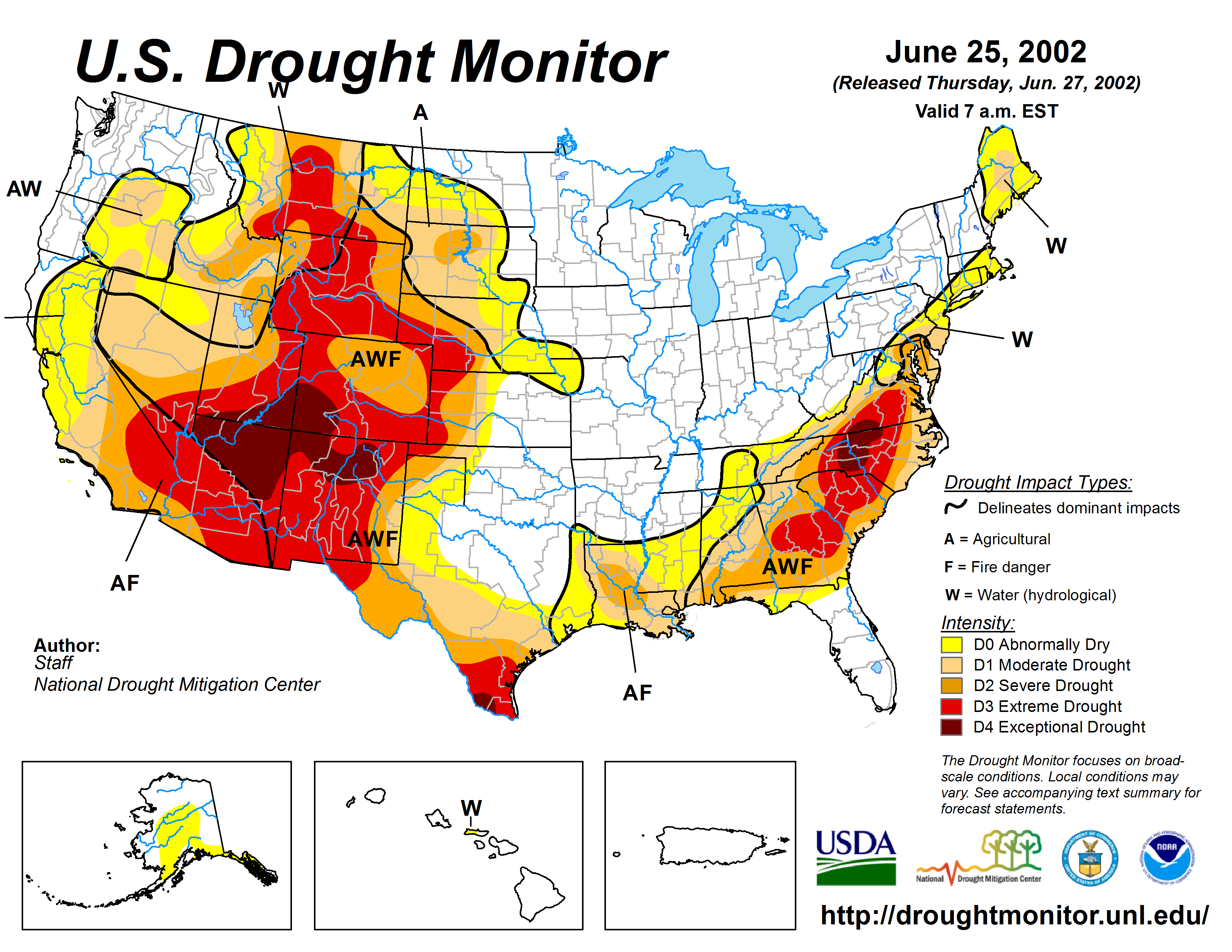
US Drought Monitor June 25, 2002.
The 2002 drought forced a new reckoning. That hot, dry, windy year revealed the inadequacy of Aurora’s portfolio of water rights and storage, both for that intense drought but also in regard to projected population growth. The city’s utility manager warned of dire reductions if snow didn’t arrive. It did the next spring, on St. Patrick’s Day of 2003, but the episode revealed the city’s vulnerabilities.
Both reuse and conservation became an active part of the municipal agenda. Since then, per-capita water use has declined by 36%. The population during that time has grown by 30%. The city offered rebates to residents willing to replace their thirsty turf.
In 2022, though, the city recognized the fallacy of creating a bigger problem that would have to be addressed later.
York, a landscape architect by training with experience in Las Vegas, contends that pleasant urban landscapes can be created with lesser volumes of water. It just takes more thoughtfulness about the function.
“That function should not be that ‘It looks pretty’ and that is all that it does,” York said. “A water-wise landscape, done correctly with species variation, can be far more attractive than the monotonous green carpet turf found in most places.”
Aurora Mayor Mike Coffman said homeowners resisted the ban at first, as did some members of the City Council, who saw it as going too far. They were convinced by Coffman that taking action now may prevent more dramatic actions in the future if the Colorado River situation deteriorates further. Aurora gets 25% of its water from multiple sources in the Colorado River basin.
There were also arguments that water-wise landscaping is ugly.
“I don’t think it’s ugly,” Coffman said in an interview. “What is ugly is when homeowners, because of the cost of water, give up on their yards. That’s ugly. But anyway, it’s the new reality we live in, and people have to get used to it.”
Native grasses use far less water than Kentucky bluegrass and other imported species but can look bedraggled, as was evident in September at this site near the Colorado State University Spur Campus in Denver.
CREDIT: ALLEN BEST/BIG PIVOTS
Down the Colorado River
Nevada and California have adopted far more significant restrictions.
A century ago, when the Colorado River Compact was crafted, Las Vegas had a population of little more than 2,000. The compact allocated only 300,000 acre-feet to Nevada, compared with 4.4 million acre-feet for California.
By 1996, Las Vegas was becoming a metropolitan area, and lawns replicating those found in Midwestern towns were still being planted in an environment of soaring summer heat and only 4 inches of average precipitation. The Southern Nevada Water Authority began offering incentives for turf removal. That program has since then cost $285 million, according to a January 2023 report prepared for the Colorado Water Conservation Board.
In 2021, with the notion of an empty Lake Mead becoming an all-too-real possibility, Nevada banned all ornamental turf dependent upon Colorado River water. Ornamental in this case applies to grass used in street medians, entrances to developments and office parks — in general, places where people rarely set foot except to mow. This covers about 31% of all the grass in the Las Vegas area.
California also took a very aggressive step in 2023. The law, Assembly Bill 1572, prohibits using drinking water for purely decorative grass in medians and outside business and in common areas of homeowner association neighborhoods, the Los Angeles Times reported in September. The ban will take effect in phases between 2027 and 2031. It exempts sports fields, parks, cemeteries and residences.
Metropolitan Water, the agency that supplies wholesale water to most of Southern California, estimates that the bill will save 300,000 acre-feet. That’s equal to Nevada’s Colorado River allocation.
Sterling Ranch may be Colorado’s best example of judicious water use. The development of more than 3,000 houses lies in the southwest corner of metropolitan Denver. The developer set out to do better than 0.75 acre-feet annually per single-family residence, which is Douglas County’s requirement. It aimed for 0.4 acre-feet but has come in at 0.2 acre-feet. The developer expects an apartment complex will yield even less consumption, at 0.14 acre-feet per unit.
Andrea Cole, general manager of Dominion Water & Sanitation District, the water provider at Sterling Ranch, said “conservation” is not used in messaging “because it implies that it was yours to use and we are asking you to please use less.” At Sterling Ranch, she said, developers combined demand-management techniques — including higher rates for outdoor water use — with land-use planning to dial down water use.
Several Colorado jurisdictions have taken more-limited action in the past several years. In August, for example, Broomfield adopted a code limiting new turf grass to 30% of front and side yards of detached single-family homes and commercial properties. Turfgrass must primarily consist of low-water grasses. Both a city and a county, Broomfield has 77,000 people but with expectations of growing to 125,000 as land is developed.
In Edgewater, a municipality of moderately dense neighborhoods west of downtown Denver, redevelopment will be the primary target of regulations adopted in November. The regulations limit Kentucky and other cool-weather grasses to 25% of residential areas. It also has limitations in commercial and other areas similar to what is proposed in the proposed state law.
Paige Johnson, sustainability director for Edgewater, said the primary goals are saving water and creating and sustaining robust and diverse natural ecosystems.
In Castle Rock, areas surrounding a football field are planted with native grasses that use less water. Waterwise regulations typically exempt athletic fields, parks and other common and higher-use areas from prohibitions against imported grasses.
CREDIT: ALLEN BEST/BIG PIVOTS
And in Castle Rock
Castle Rock gets virtually no water from the Colorado River except for a tiny bit of reused water. It was a late bloomer among cities of metro Denver with fewer than 4,000 residents in 1980. The limited water from Plum Creek combined with wells drilled into aquifers of the underling Denver Basin were just fine.
It now has 80,000 residents but plans for 142,000 in decades ahead. In anticipation of that much larger population, it has been offering rebates of $1.50 per square foot for replacement of water-thirsty grasses with native species that use less water. Those who replace grass with concrete or artificial turf can get only $1. Both exacerbate heat-island effects of high temperatures and create more runoff problems during rains.
Castle Rock calls these less-thirsty yards “ColoradoScapes.” Such areas must have 75% vegetation to qualify.
In October 2022, after several years of outreach, Castle Rock adopted regulations that lifted the bar several notches higher. No thirsty grasses can be planted in front yards. Backyards, where families tend to gather, can have a maximum of 500 square feet. Castle Rock also banned new ornamental turf — grass that no one actually walks on — in road medians and at entrances to housing projects.
Mark Marlowe, director of Castle Rock Water, emphasizes cost in justifying the restrictions. Building water-treatment plants and distribution to meet peak demand during the hot days of summer bears a large price tag. Getting additional water from more distant places is also expensive.
Castle Rock residents today use 118 gallons per capita on average daily. “If we can get our community below 100 gallons per capita a day, we can save upward of $70 million in long-term water rights and infrastructure,” Marlowe said.
Similar to other Colorado cities, 50% of Castle Rock’s water was devoted to outdoor landscaping. That has declined to 42%. Marlowe projects it will continue to drop as Castle Rock Water has set a goal of removing 30% of the current non-functional grass turf in the municipality and replacing it with Coloradoscape by approximately 2050.
Limiting water devoted to outdoor landscaping helps Castle Rock in another way. Water applied to outdoor landscapes mostly disappears into the atmosphere, while about 90% of water used indoors gets treated. In many places in Colorado, this treated water is released into streams and rivers to satisfy those with water rights downstream.
Because it draws the water from the aquifers, Colorado water law allows Castle Rock to reuse that water repeatedly, to “extinction.” Overall, the city hopes to achieve 75% renewable water by midcentury, reserving use of the Denver Basin aquifers to droughts.
Denver has a very different situation. A century ago, when Castle Rock was a small ranch town of fewer than 500 residents, Denver already had 256,000 people. Envisioning a far larger city, civic leaders had laid plans for Colorado’s first major transmountain diversion to take water from the Fraser River via the Moffat Tunnel.
Now, the city is landlocked, able to grow upward but not outward. Water use has leveled off. The city has a strong water portfolio but wants to help residents learn how to use less water for landscaping.
“You don’t have to have wall-to-wall grass to have an inviting city,” said Denver Water’s Fisher. He cautioned against pointing fingers at those with cool-weather turf. “I do think we’re trying to slowly change how people approach their landscapes and make that connection back to water,” he said.
Only trees get watered at the Hugo Golf Club, located in Lincoln County in eastern Colorado. The fairways consist of buffalo grass, cactus and sand.
CREDIT: COURTESY PHOTO/LINCOLN COUNTY ECONOMIC DEVELOPMENT CORPORATION
A golf course without water hazards
In Colorado Springs, the state’s second-largest city, overall water demand has remained relatively flat since the mid-1980s. During that time, the city’s population has nearly doubled. Most of that 40% decline in per-capita water use has occurred since 2001. Other Front Range cities similarly report substantial declines of 35% to 40%.
Colorado Springs Utilities has championed the use of native grasses in urban landscaping but also paid careful attention to the efficiency of preinstalled irrigation systems as it plans for a population of 800,000 in coming decades. It’s now at 500,000.
The city also wants to help residents maintain their yards using water-wise techniques. Between 25% and 30% have stopped irrigating their yards. That neglect “has a significant, negative impact on our collective quality of life and economic vitality,” said Colorado Springs Utility in a statement. “Our work is to reach those customers as well.”
The changing climate also poses challenges. Julia Galluci, supervisor of water conservation for Colorado Springs, said the city expects to have water resources available for outdoor watering about one day a week by 2050. “We are trying to implement the kinds of landscapes that can survive in that kind of climate and environment,” she said.
Colorado Springs has been moving slowly, only this year moving into its messaging of the more general population. “It’s not a quick fix,” said Galluci.
Of course, if the Colorado River situation deteriorates rapidly, city and state policies may accelerate. After last winter’s strong snowpack, the big reservoirs— Mead and Powell — rebounded slightly after dropping to perilously low levels. In April 2022, railroad tracks on a ledge of the canyon wall that had been abandoned upon completion of the Glen Canyon Dam re-emerged after being underwater since soon after the dam was completed in 1966. Those artifacts are underwater again, but no one knows for how long.
As for new golf courses, they may look different in the future. Aurora’s recent commitment to restrictions was triggered by a golf course approved long before. The golf course has been granted authority to move ahead after agreeing to use a grass variety that will cause it to use 250 acre-feet annually instead of the 400 acre-feet that would be needed by more conventional grass.
Developers of the golf course will tap an aquifer with a projected 50-year supply. When that aquifer goes dry, they will not seek to use city water, Other golf course developers may also want to study new hybrid species of grass. A new type of Bermuda grass, for example, uses 50% to 75% less water.
Colorado has two golf courses that use no more water than comes from the sky. One is a nine-hole municipal course at Springfield, in southeast Colorado. The other lies 100 miles east of Aurora, near Hugo. The Hugo Golf Club falls under the heading of “pasture golf.” It has 300 trees that get watered, but the fairways where bison once grazed now consist of native buffalo grass, cactus and sagebrush. For greens, it has sand. Naturally, it has no water hazards.
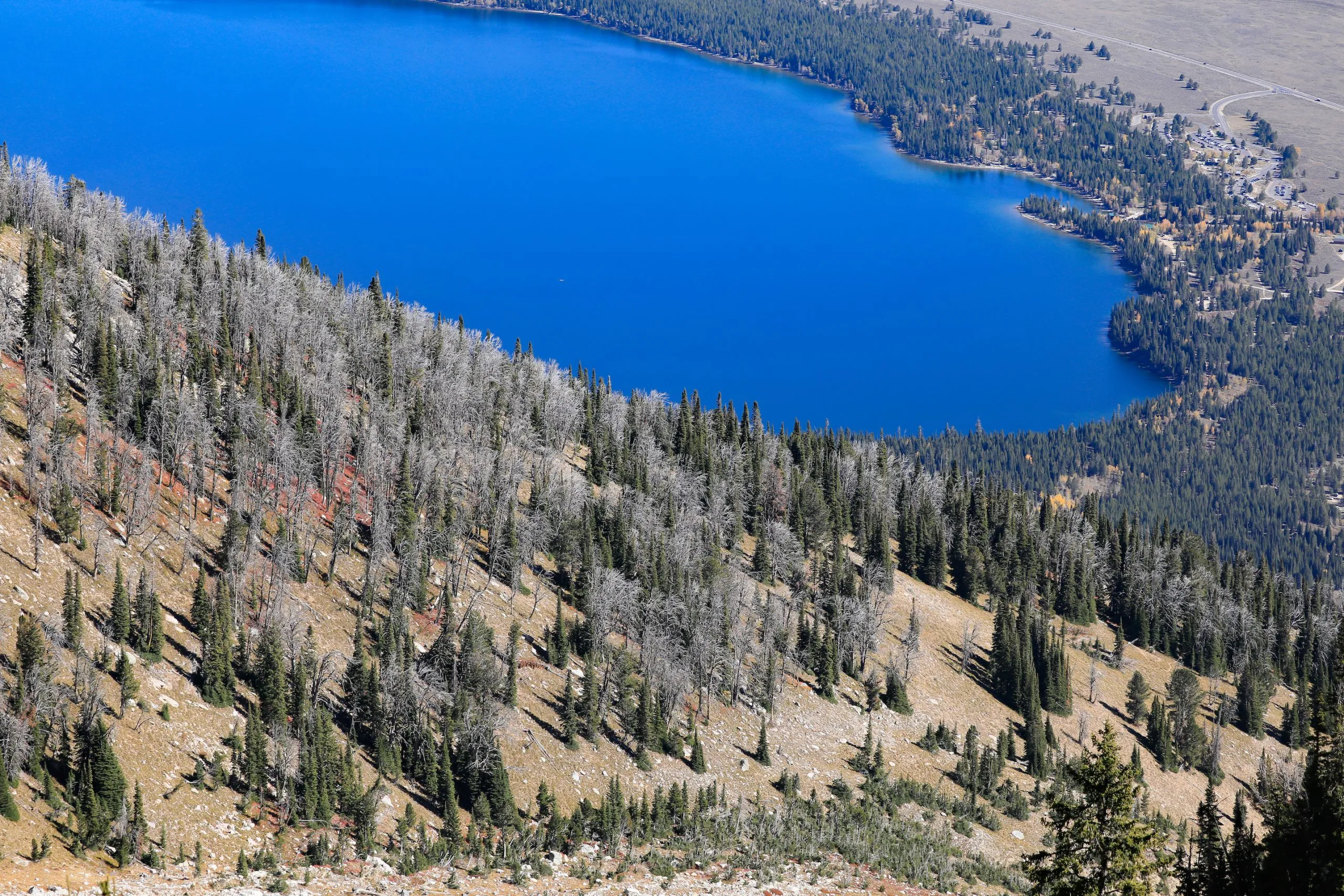
Whitebark pines killed by a pine beetle epidemic that spanned from 2004 to 2012 blanket the steep face of Teewinot Mountain overlooking Jenny Lake. (Colin Wann/Creative Ascents/Northern Rockies Conservation Cooperative)
Vegetation ecologists monitoring the latest mountain pine beetle epidemic fear for the survival of the Teton Range’s remaining ancient whitebark pine stands.
A keystone species that gained Endangered Species Act protections early this year, whitebark pines were hit hard by a plague of mountain pine beetles that spanned from 2004 to 2012.
A cold snap ended that wave, giving the region’s embattled whitebark pine a temporary reprieve. Four years ago, however, scientists monitoring the gnarled high-elevation conifers started to see a larger concentration of “brood trees” harboring increasing numbers of the bark-boring insects.
“It’s just another beetle epidemic happening because they are not being slowed down by cold falls and springs — like they naturally were before,” said Nancy Bockino, a Northern Rockies Conservation Cooperative whitebark pine field ecologist who has long monitored the species in Grand Teton National Park. “And it’s getting worse.”
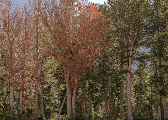
The red trees are whitebark pines that were recently killed by mountain pine beetles during an ongoing epidemic that started in 2019. More than a third of all beetle-killed trees in Grand Teton National Park were attacked over the last four years. (Colin Wann/Creative Ascents/Northern Rockies Conservation Cooperative)
Bockino wrote about the ongoing infestation in a publication called Nutcracker Notes, which is produced by the Whitebark Pine Ecosystem Foundation. Her paper was ominously titled — “Here we go again: The mountain pine beetle is killing our remaining old whitebark” — and in the article she referred to the repeat epidemic as a “grave situation.”
“First,” Bockino wrote, “the loss of any of the few remaining cone-bearing whitebark is a significant setback for conservation and restoration.”
Moreover, she added, “a second epidemic may result in so few whitebark pine that the delicate and obligate mutualism between the tree and the Clark’s Nutcracker could collapse.”
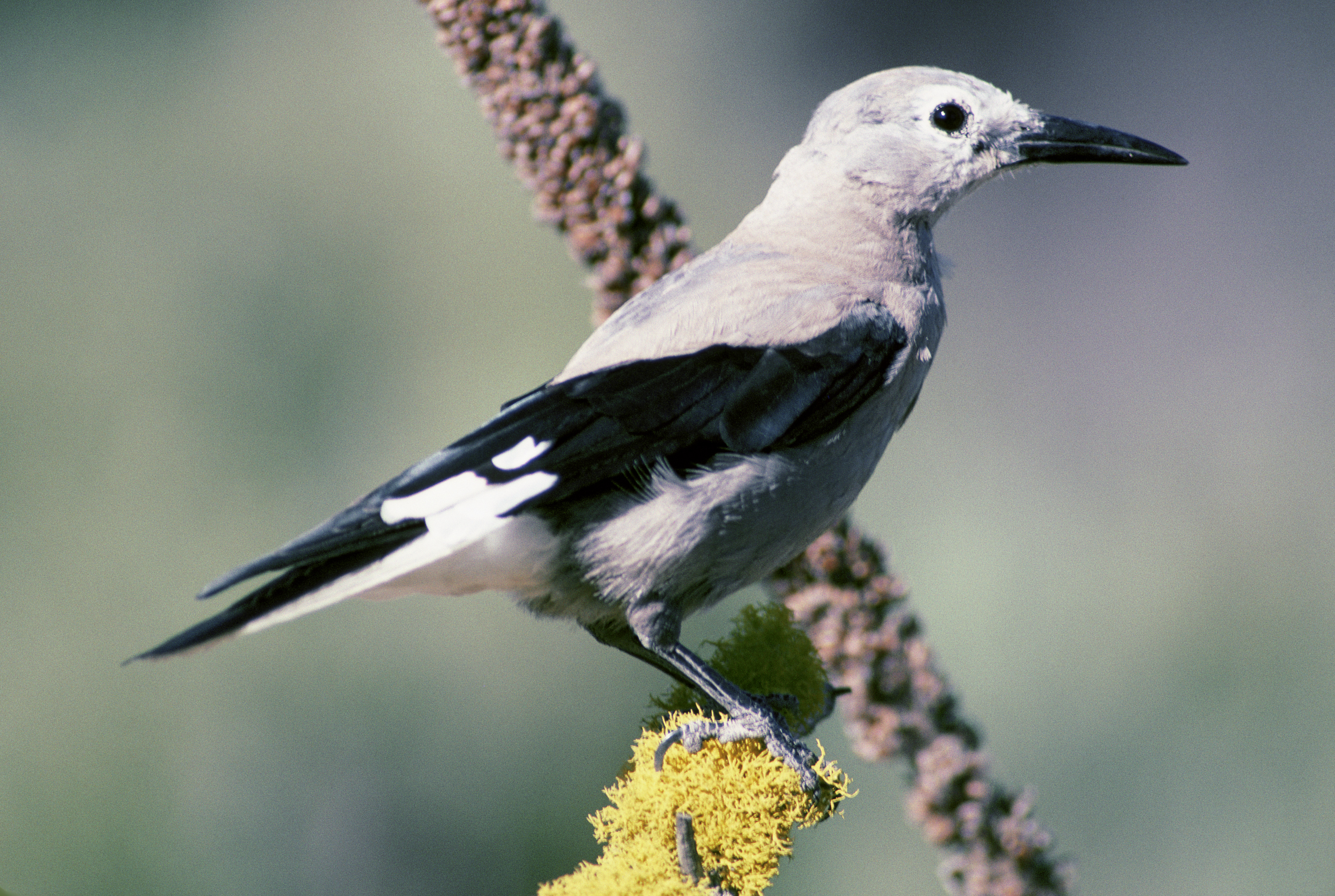
Clark’s Nutcracker (Nucifraga columbiana) photographed in Deschutes National Forest. By David Menke – This image originates from the National Digital Library of the United States Fish and Wildlife Service. Images from the United States Fish and Wildlife Service., Public Domain, https://commons.wikimedia.org/w/index.php?curid=266346
The Clark’s Nutcracker is a species of jay that whitebark pine depends upon to disperse its seeds. But dependency in the relationship is not entirely mutual: nutcrackers can subsist on other pine seeds when whitebark seed stocks are poor. In its rule listing whitebark pine as a threatened species, the U.S. Fish and Wildlife Service wrote that climate change could negatively affect nutcracker populations, potentially exacerbating whitebark decline.
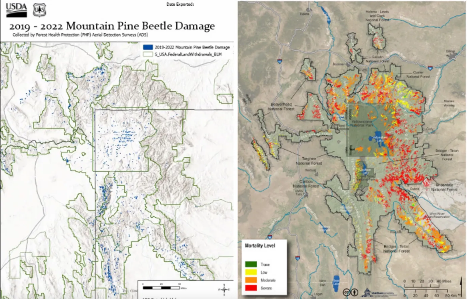
Mountain pine beetle activity in the Greater Yellowstone Ecosystem from 2019 to 2022 from Forest Health Protection aerial surveys. Left, each blue dot is a severity-weighted polygon that represents up to 99 brood trees per acre. The right panel shows estimated mortality (low, moderate, severe) from Landscape Assessment System data 2003-2009. (Nutcracker Notes/Journal of the Whitebark Pine Ecosystem Foundation)
The Tetons and Wind River Range have historically been bright spots for whitebark pine conservation within the Greater Yellowstone Ecosystem.
Whitebark pine seeds are a major food source for grizzly bears, and during the height of the 2004-to-2012 epidemic, beetle-killed whitebark monitored by the Interagency Grizzly Bear Study Team amounted to 76% of all the trees being monitored. A higher percentage survived in Grand Teton National Park, however.
Bockino and others surveyed Teton Range whitebark pine in 2022 to try to get a grip on the scope of the epidemic. They found that 54% of the overstory was dead from pine beetles. Just more than a third of those dead trees — 35% — showed signs of beetle attack between 2019 and 2022.
The reemergent threat from mountain pine beetles is also hitting whitebark hard in other southern swaths of the Greater Yellowstone Ecosystem. Increasing beetle activity has been observed in the Wyoming, Salt River and Wind River Ranges and at sites on the Caribou-Targhee National Forest, according to Bockino.
Unlike the nonnative fungus blister rust — another threat to whitebark pine persistence — mountain pine beetles are a native species that the long-lived tree evolved alongside. What’s changed and made pine beetles an existential threat are the survival rates of the bark-boring insect. Extreme cold in the spring and fall can knock back beetle populations, but the subzero temperatures needed for beetle die-offs are happening evermore infrequently as the climate warms.
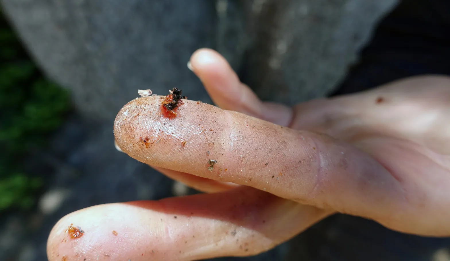
A pine beetle found in a whitebark pine stand in Grand Teton National Park. (Colin Wann/Creative Ascents/Northern Rockies Conservation Cooperative)
In the rule establishing whitebark pine as “threatened” under the ESA, the Fish and Wildlife Service used 60-year intervals between outbreaks for scenarios modeling how the species would fare. “Unfortunately,” Bockino wrote in her article, that interval is “in contrast to what is happening in the GYE,” where there have now been two epidemics in less than 20 years.
“Real-time management action is urgent,” she wrote. “The prioritization of retaining every possible existing seed tree at all costs is unquestionable.”
Grand Teton National Park vegetation managers aren’t standing idly by.
“We know that without intervention, the persistence of the species is in jeopardy,” said Laura Jones, the park’s chief of vegetation management. “We’ve been gearing up for restoration actions and we’ve continued doing work protecting trees. And we do have some new funding sources.”
Grand Teton crews will begin planting 4,000 whitebark pine seedlings in the fall of 2025, Jones said. And there are ongoing efforts, she said, to install beetle traps at the known blister rust-resistant whitebark stands.
In healthy stands of whitebark pine, Bockino and others have also continued hanging pouches of verbenone, a pheromone that signals to the beetles the trees are already occupied. There was talk of stopping the labor-intensive pouch-hanging efforts during the lull between beetle epidemics.
“Right about that time, I was like, ‘Wait a minute,’” Bockino said. “We were having this massive outbreak on Static Divide, with hundreds of trees getting killed over there. That was 2019. It just kept growing.”
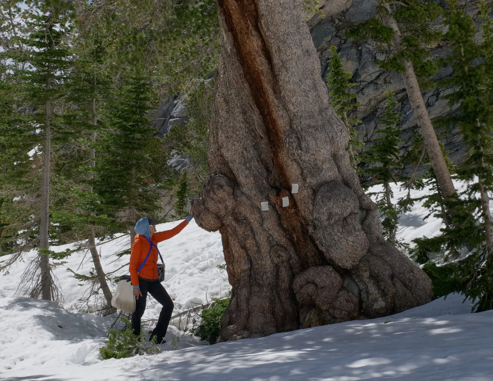
egetation ecologist Nancy Bockino sizes up a giant living whitebark pine in Grand Teton National Park in 2020. (Colin Wann/Creative Ascents/Northern Rockies Conservation Cooperative)
Bockino has even gone so far as to ski up into the Tetons in the winter to strategically strip the bark off of beetle-infected trees. That fatally exposes the brooding insects to the sun and the cold, Bockino said.
At least one ecologist is committed to doing whatever it takes to keep old, gnarled whitebarks that remain alive.
“Think about it. A 700-year-old whitebark pine is beyond precious,” Bockino said. “That’s a long freaking time. Personally, I’m trying to do everything I can to save those.”
The 32-foot-tall sound erected at Northglenn’s Northwest Open Space is hiding a test drill. The city is testing pumping drinking water underground to store it at the site. Credit: Courtesy / City of Northglenn
“Normally what we do is pump our water from Berthound Pass into Standley Lake, but there are evaporative losses there,” said Northglenn Water Resource Administrator Silas Adams. “What we’re testing is storing this water in case we need it. You say you plan for a rainy day, but we’re trying to set some water aside in case we have a dry day — or an extended drought period.”
Crews were set to begin drilling into the aquifers at the city’s 2350 W. 112th Ave. water treatment facility in the Northwest Open Space during the first week of January. Drilling should be finished in April…Denver Water has tested underground storage, but Northglenn is the first northern metro community to try it. The plan is to test the water’s quality before pumping it underground, beginning in April. The tests will look for trace elements, minerals and potential pollutants. Then, water will be pumped out from the aquifer a year or more later and will be tested again…
Water stored in Colorado’s Denver Basin aquifers, which extend from Greeley to Colorado Springs, and from Golden to the Eastern Plains near Limon, does not naturally recharge from rain and snow and is therefore carefully regulated. Courtesy U.S. Geological Survey.
Colorado’s Front Range sits atop several aquifers, from Wyoming south to Colorado Springs — the Dawson, Denver, Arapahoe, Laramie/Fox Hills and the Pike Rampart aquifers. Adams said Northglenn’s goal is to pump water it gets from Berthoud Pass via Clear Creek into the Arapahoe and Laramie/Fox Hills aquifers. The Arapahoe aquifer covers some 4,700 square miles and is as deep as 1,700 feet below ground. More than 1,000 wells have been drilled into the aquifer, including several Colorado municipalities. The deeper Laramie/Fox Hills aquifer covers 6,700 square miles and is 2,400 feet below ground at its deepest points — the deepest of the Front Range aquifers. Adams said Northglenn crews will need to drill about 500 feet down to reach the Arapahoe aquifer and 1,400 feet to reach the Laramie/Fox Hills aquifer…Northglenn already has the rights to pump a limited amount of water from the aquifers, but Adams said there is no limit to how much water it can pump in and then pump back out.
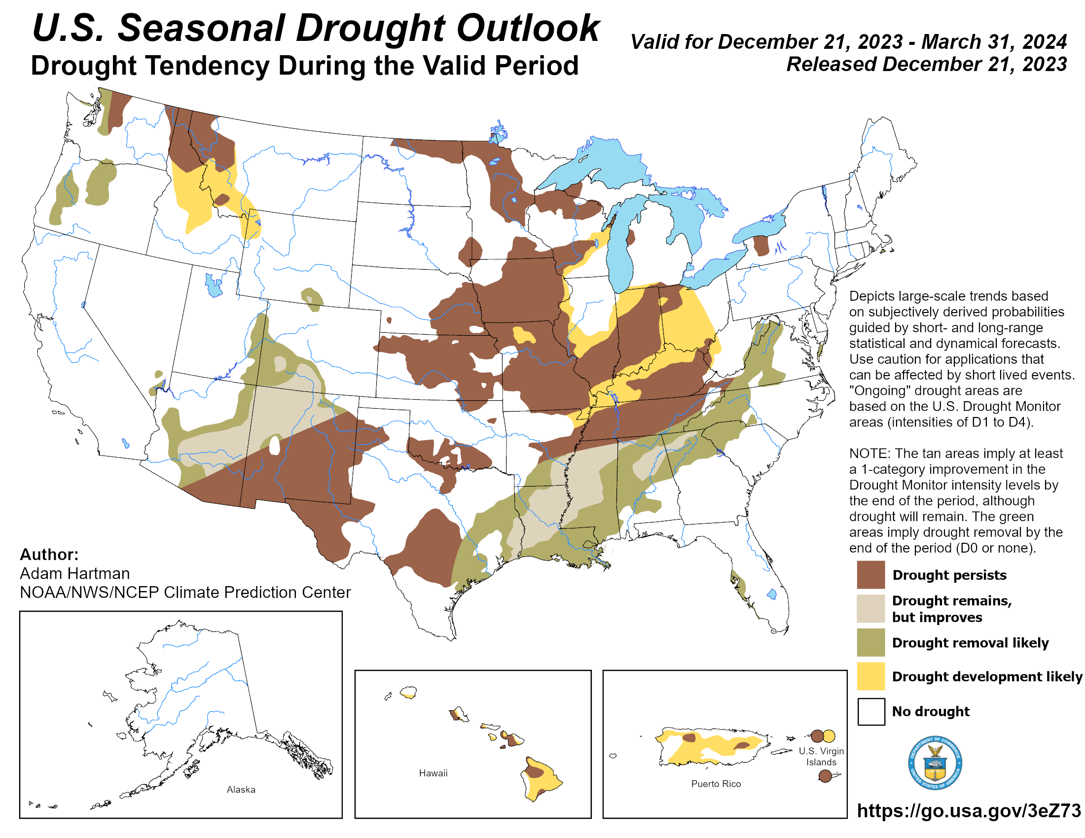
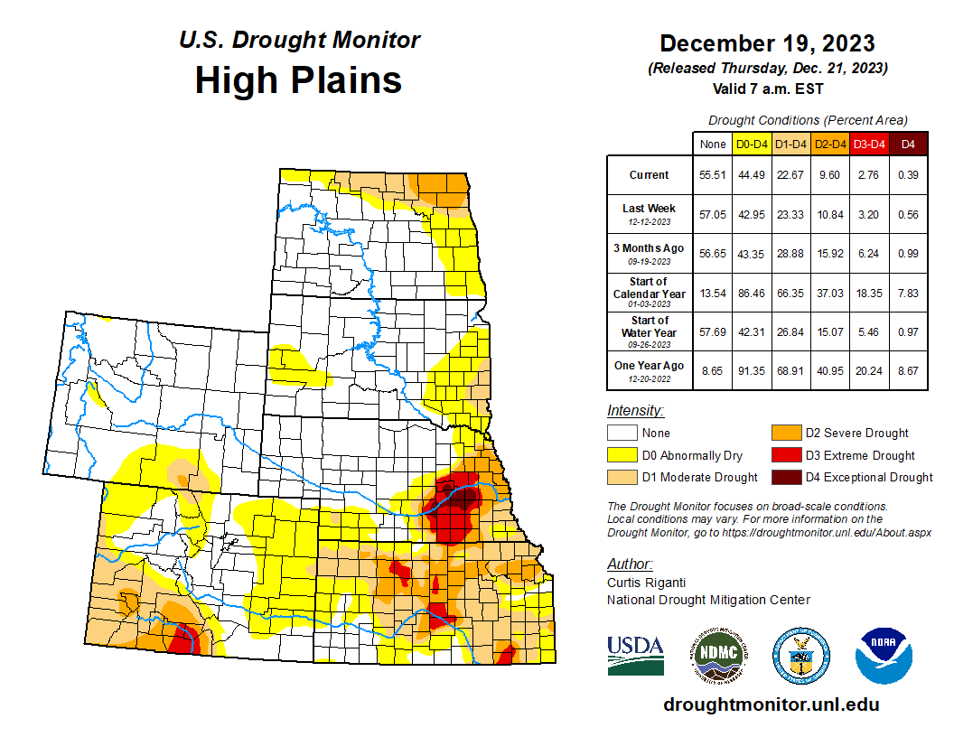
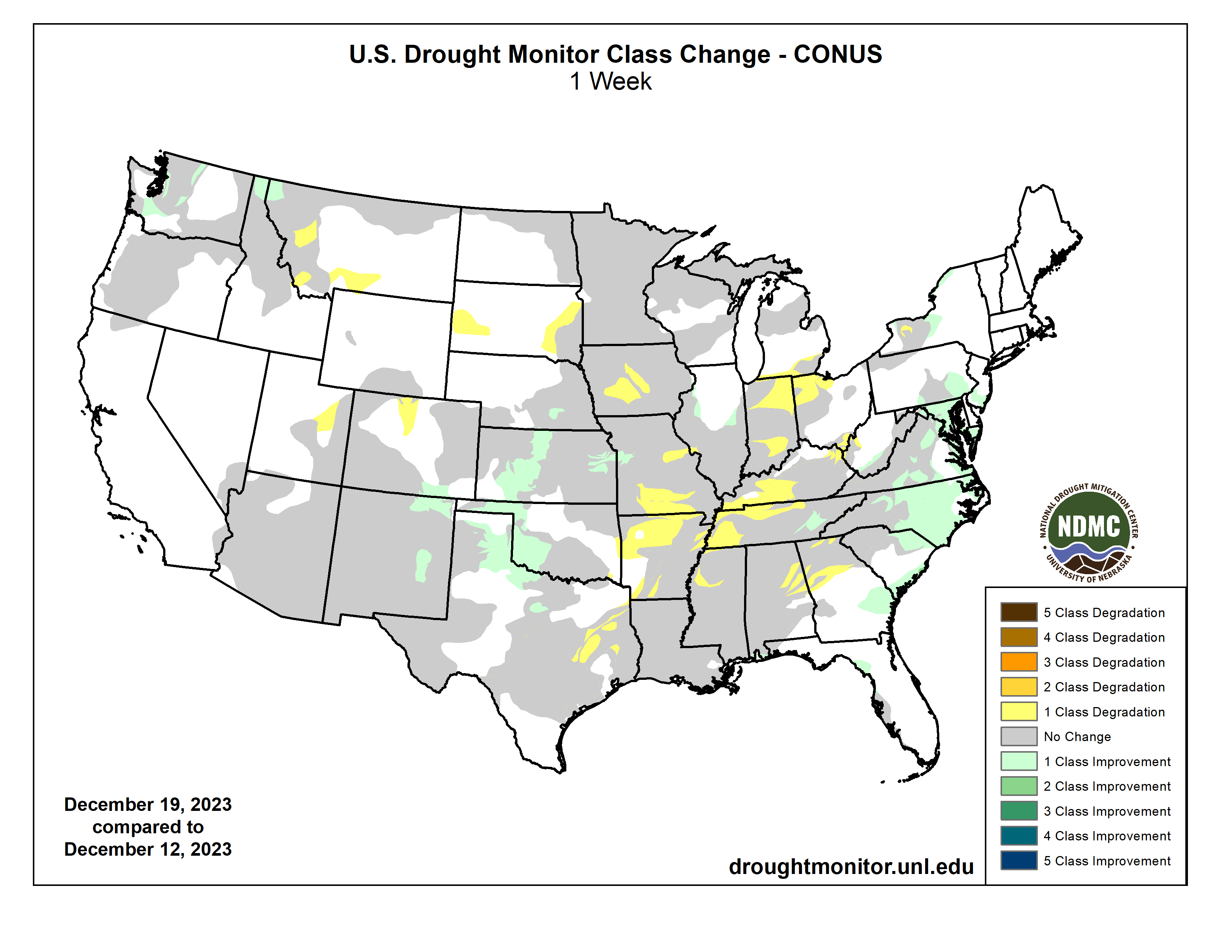
A low pressure system developed over the central Plains in conjunction with an amplifying upper-level trough dipping into the northern Plains brought active weather across much of the central to eastern U.S. Warm and moist air from the Gulf of Mexico moved northward ahead of the developing low pressure, producing widespread moderate to heavy rainfall from Texas to Louisiana. Meanwhile, a cold air mass from Canada dipped into the northern portions of the U.S. brought blizzard conditions to portions of the Central Plains and Upper Midwest. Temperatures were above-normal across most of the U.S., by as much as 20+ degrees F above average in parts of the Upper Midwest and Northern Plains. The most widespread improvements were made to parts of central Texas, eastern Nebraska, eastern Kansas, southern Louisiana and from northern Alabama to western North Carolina, where above-normal precipitation was observed this past week. Dry conditions continued across the eastern portions of the Southern region, with degradations occurring across much of Mississippi and into Arkansas and Tennessee. Drought and abnormal dryness were also expanded or intensified in portions of the northern Rockies and in parts southern Illinois, southern Texas and in the Southeast. In Hawaii, heavy rainfall improved conditions over parts of Kauai, Oahu and the Big Island, while no changes occurred on Molokai, Lanai or Maui…
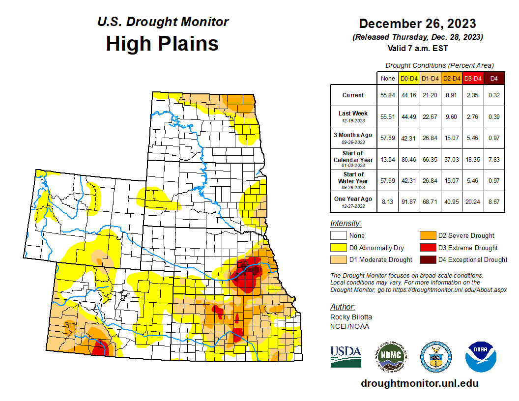
Heavy precipitation fell over much of eastern portions of the region, where rainfall totals were greater than 600% of normal and ranged between 1 to 4 inches this week. Exceptional drought (D4) was improved in eastern Nebraska, while extreme drought (D3) was improved in eastern portions of Nebraska and Kansas where precipitation totals were up to 3 inches above normal for the week. Above-normal precipitation also led to improvements to severe drought (D2) and moderate drought (D1) over parts of eastern Kansas and northeast Nebraska. Abnormal dryness (D0) was improved along parts of the eastern border of the High Plains and in portions of western Kansas and eastern Colorado. Conversely, dry conditions persisted in portions of eastern Colorado and Wyoming where precipitation remains below normal this week. Deteriorating conditions shown in short-term SPI/SPEI, streamflow, soil moisture and snow water equivalent (SWE) data justified degradations across these states. Abnormal dryness was expanded in parts of northern Colorado and in eastern and southern Wyoming, while abnormal dryness was introduced in north-central and northeast Wyoming…
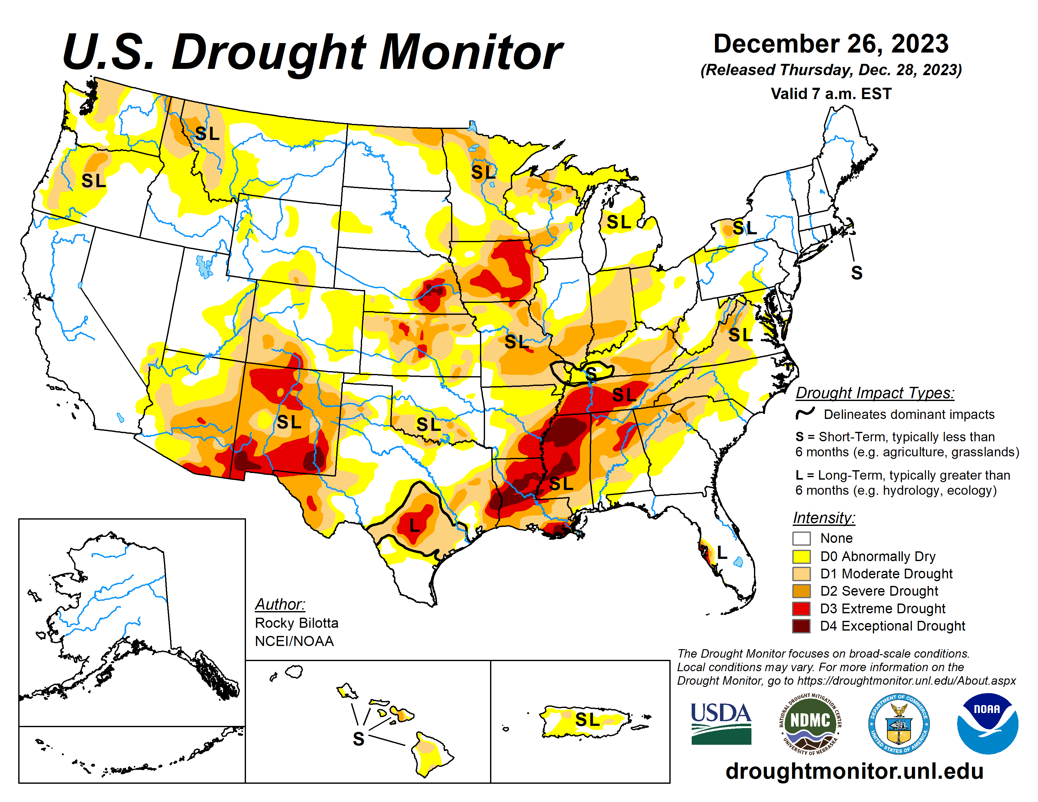
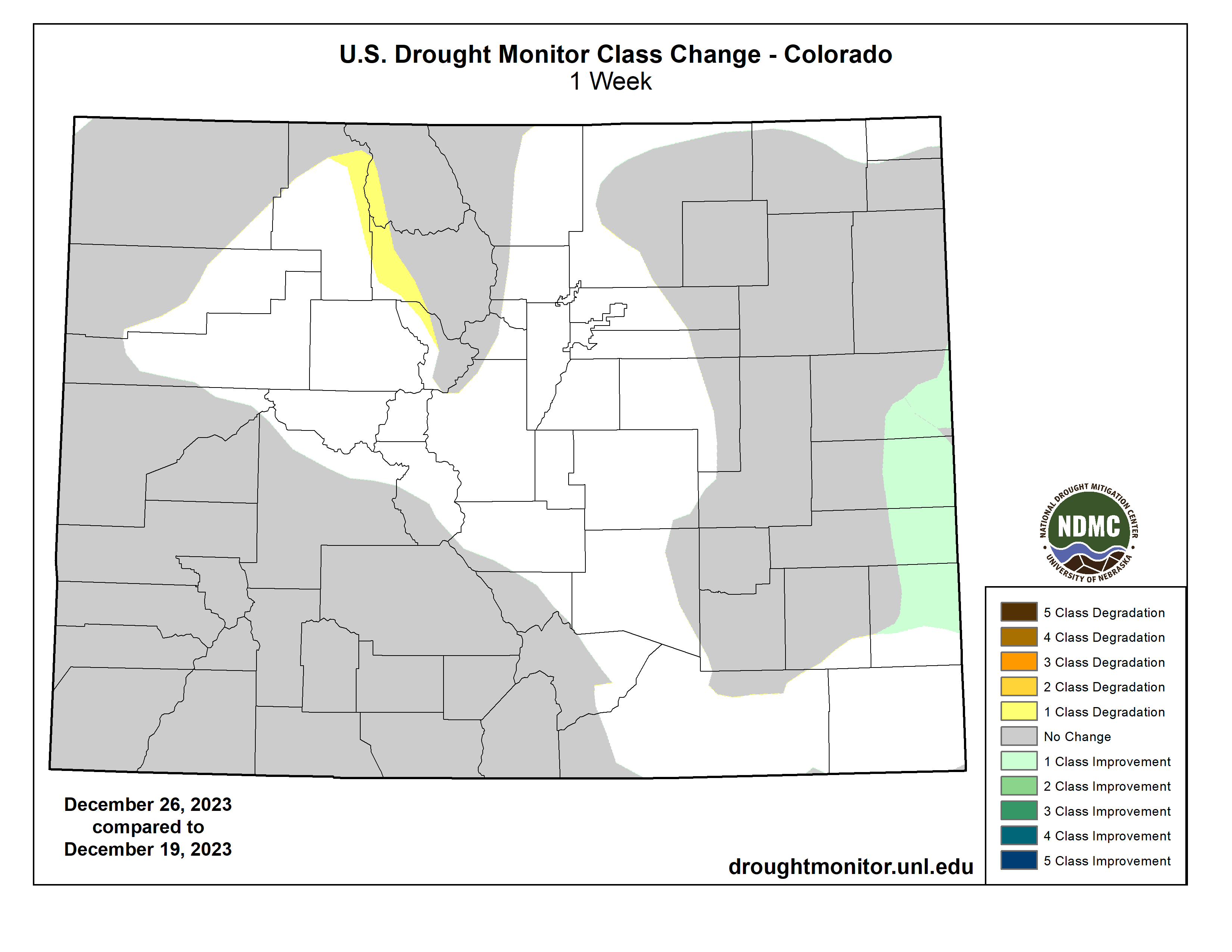
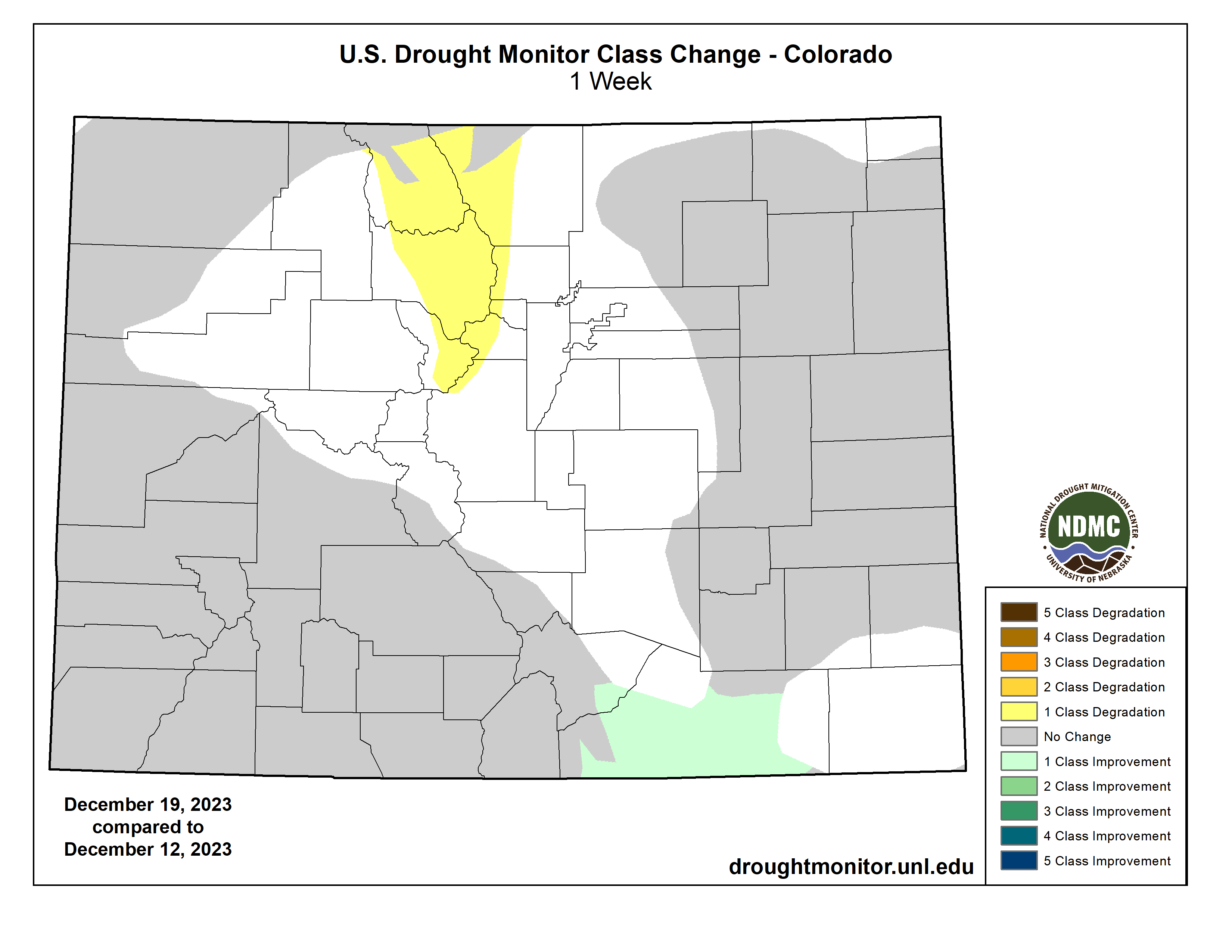
Colorado Drought Monitor one week change map ending December 26, 2023.
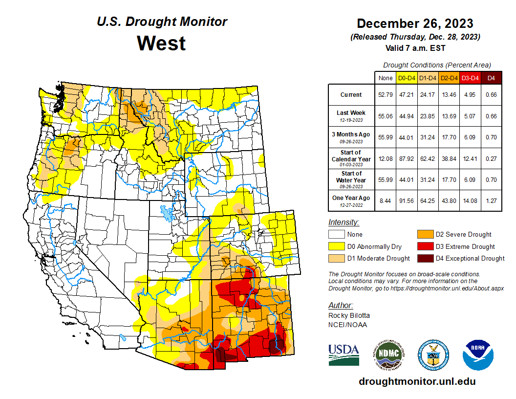
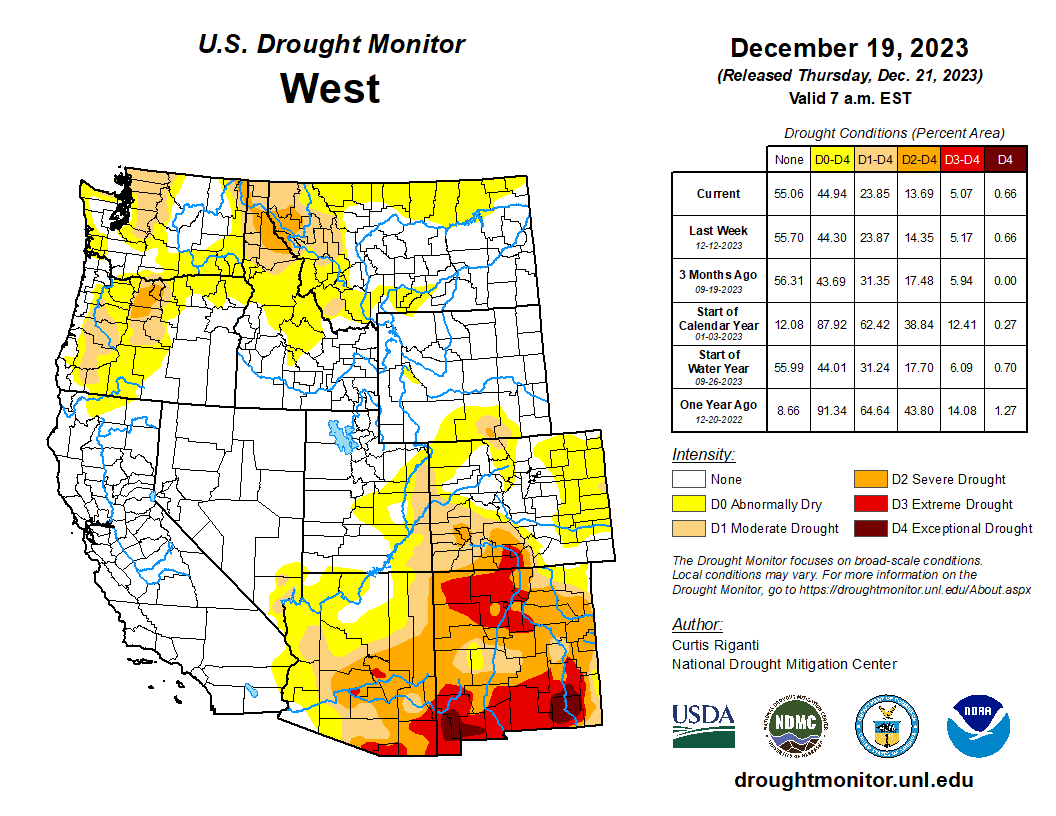
Much of the West remained as status quo this week. Precipitation fell across much of the region, which was enough to prevent further degradation but not enough to warrant large improvements. Heavier precipitation fell across the southern portions of Arizona and New Mexico, where rain totals were greater than 600% above normal this week. These beneficial rains, along with precipitation percentiles and short-term SPI/SPEI, soil moisture and streamflow data, resulted in abnormal dryness (D0) and moderate (D1) to extreme (D3) drought improvements along the southern border. Portions of La Paz and Yuma counties reported weekly rainfall totals up to 6 inches above normal. Conditions remained dry in northern parts of the Rockies, resulting in further deterioration across western Montana and eastern Idaho. Moderate drought and abnormal dryness were expanded in these areas based on short-term SPI/SPEI data, low snow water equivalent (SWE) percentiles and precipitation and soil moisture deficits. As for temperature this week, much of the region was above normal with well-above-normal temperatures were observed in parts of northeast Montana which were greater than 10 degrees F above normal…
Dry conditions continued across the eastern portions of the Southern region this week while heavy precipitation fell across much of Oklahoma and over parts of central and eastern Texas. Large portions of eastern Texas and Oklahoma received between 2 inches to 5 inches of rainfall (300% to 600% above normal) this week, resulting in improvement of exceptional drought (D4) in eastern Texas while extreme drought (D3) was removed from northeast Oklahoma and improved in parts of central and eastern Texas. Improvements were also made to moderate drought (D1) to severe drought (D2) conditions, along with abnormal dryness (D0), in this part of the region. Heavy rain was reported (2 to 4 inches of rainfall) over parts of southeastern Louisiana this week, resulting in the 1-category improvement across the area. Conversely, conditions continued to deteriorate in parts of Mississippi, Arkansas and Tennessee, where precipitation totals were 2 to 4 inches below normal this month. Exceptional drought was expanded in parts of central and northern Mississippi and was introduced into eastern Arkansas, while extreme drought was expanded into the northern portions of Tennessee and in parts of Mississippi and Arkansas this week. The expansion and intensification of drought categories were based on short-term SPI/SPEI, NDMC’s short-term blend, streamflow and soil moisture data…
Looking Ahead
During the next five days (December 26-30, 2023), An initial Plains/Midwest upper low will work to establish the eastern upper trough, and an associated surface system will spread rainfall of varying intensity over the East early-mid week along with the potential for lingering snow over the north-central Plains. Over the West, most precipitation should focus near the West Coast with a couple frontal systems tending to produce the highest totals over/near northern California. In terms of temperatures, expect unseasonably warm conditions in the East Tuesday and Wednesday ahead of the approaching frontal system. Morning lows should be particularly anomalous with readings 20-30 degrees above normal for much of the East and Upper Midwest. Warmer than normal temperatures will likely linger even longer in the Northeast through Thursday or Friday. Cooler air behind the system will initially still be on the mild side, with only slightly below normal readings over the central-southern Rockies/Plains on Tuesday. As upper troughing becomes established over the East later in the week, the Southeast and vicinity should trend cooler with temperatures dropping to 5-10 degrees or so below normal. Much of the West should see moderately above normal temperatures through the period.
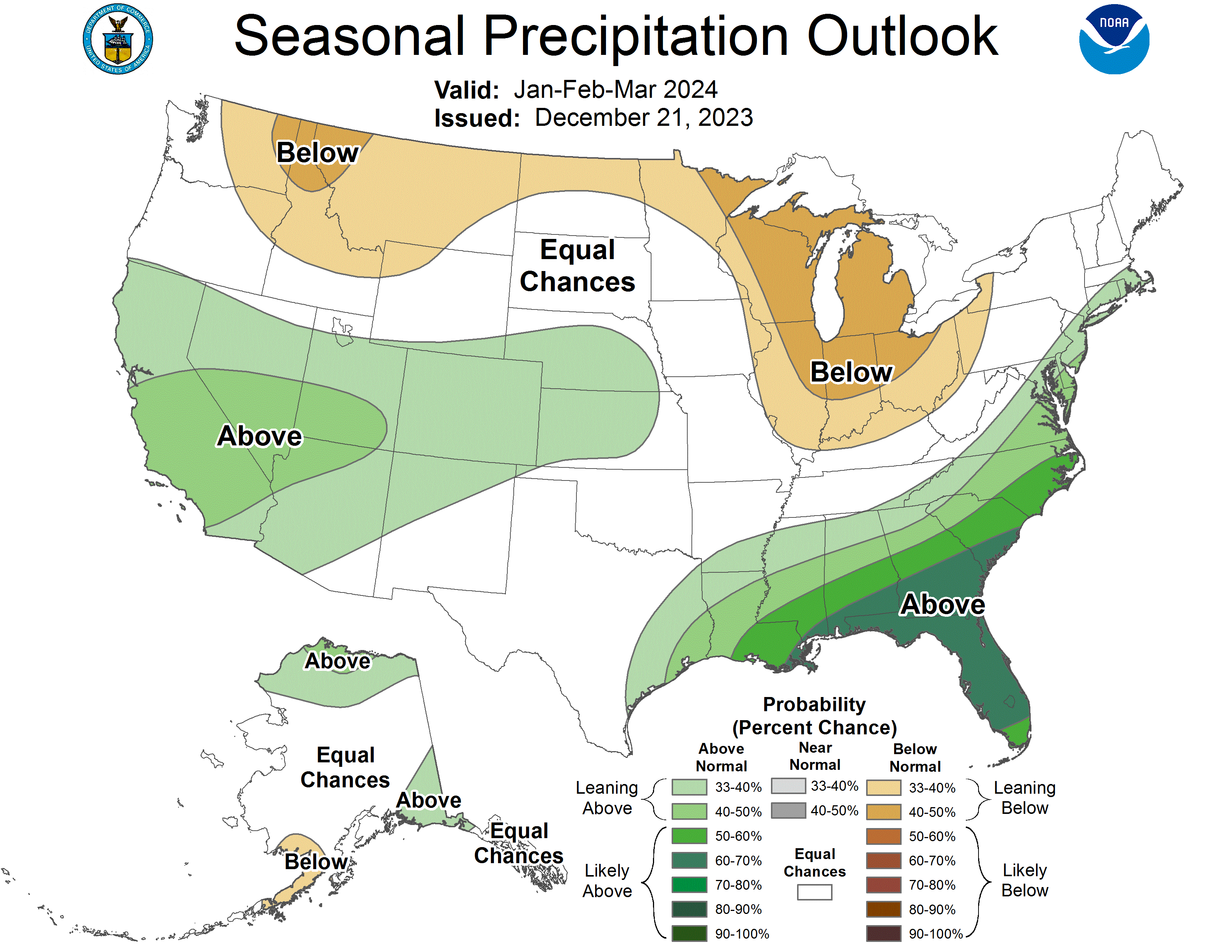
The Climate Prediction Center’s 6-10 day outlook (valid December 31, 2023 – January 4, 2024) favors above-normal precipitation from California to Alabama, and across much of Alaska, with below-normal precipitation most likely from the northern Plains to the Northeast, in portions of the Northwest and Hawaii, and in parts of southern Florida and Alaska Panhandle. Increased probabilities for below-normal temperatures are forecast for much of southeastern U.S. and on the eastern islands of Hawaii, while above-normal temperatures over much of the West, along the northern tier and in parts of the southern Plains, as well as Alaska and western islands of Hawaii.
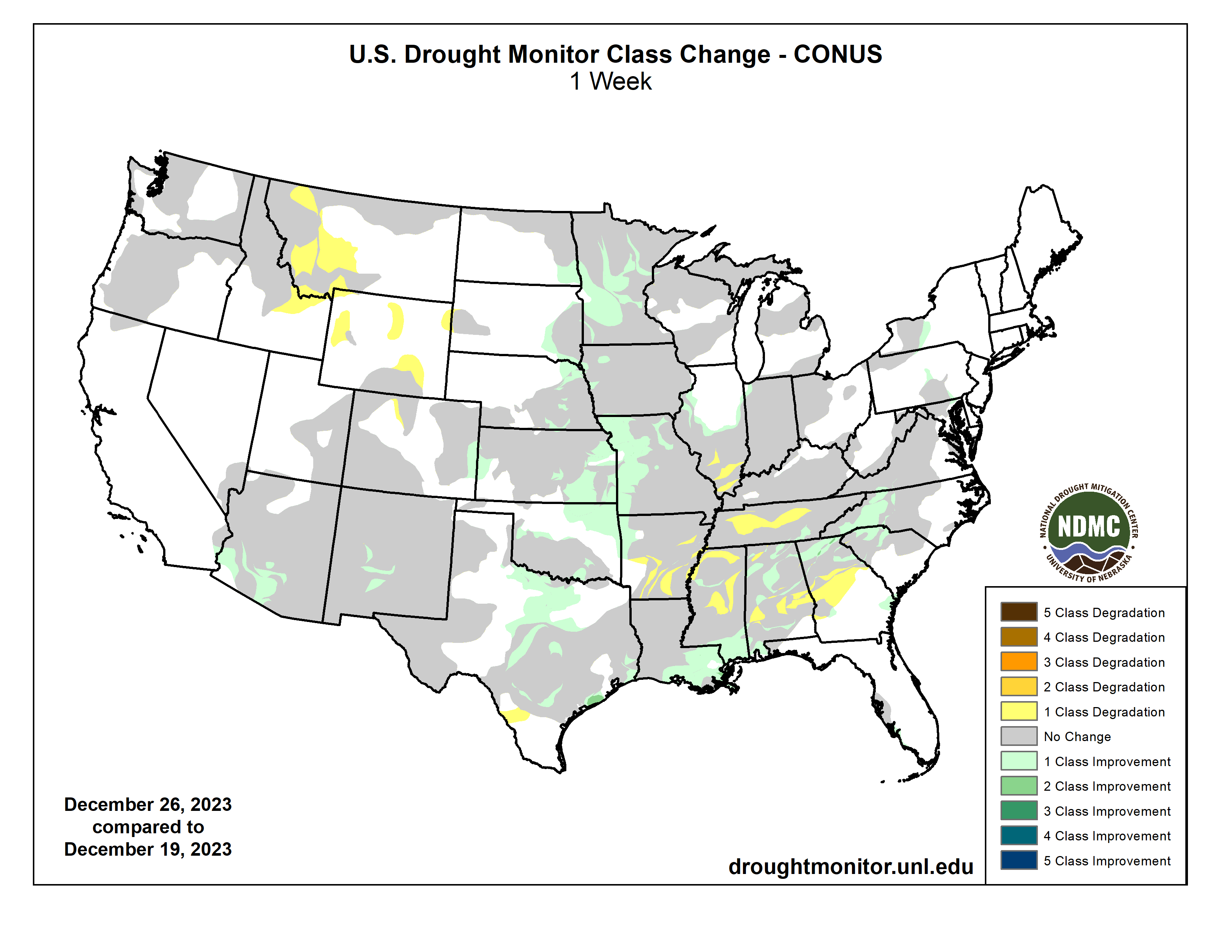
US Drought Monitor one week change map ending December 26, 2023.
At this time last year, conditions in the Colorado River Basin were dire. We knew we were heading into the first Tier 2a shortage for 2023. But we also knew that more needed to be done to stabilize the critical levels of the Basin’s two main reservoirs – Lake Powell (held back by Glen Canyon Dam) and Lake Mead (held back by Hoover Dam). Lake Powell was set to release the lowest volume since filling and Mead was anticipated to head into a Tier 3 shortage or greater in 2024. The Bureau of Reclamation (Reclamation) was considering additional protection measures as part of a Supplemental Environmental Impact Statement (SEIS) that would modify Powell and Mead operations.
So, what happened this year – and where are we headed for 2024 and beyond?
2023: Mother Nature and the Lower Basin States step up The Basin experienced excellent snowpack last winter and above average runoff in 2023. That helped forestall an immediate crisis, but more actions were necessary. In April, Reclamation released the Draft SEIS, with action alternatives that were unacceptable to the Lower Basin States. In May, Arizona, California and Nevada announced a consensus proposal to conserve historic volumes of Colorado River water in Lake Mead. With this proposal in hand, Reclamation withdrew its Draft SEIS and in October released the revised Draft SEIS with the Lower Basin States’ consensus proposal designated as an Action Alternative. We anticipate a final decision in spring 2024.
Historic conservation in Arizona Arizona has already made significant progress toward the Lower Basin States proposal, conserving those historic volumes of water in Lake Mead. In 2023, we’ve conserved nearly 950,000 acre-feet, including our mandatory 592,000 Tier 2a shortage reduction, plus an additional voluntary contribution of more than 356,000 acre-feet. A big thank you to our 2023 conservation champions.
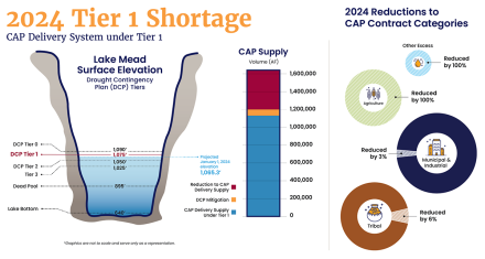
2024: A return to Tier 1 shortage The combination of favorable basin-wide hydrology and conservation efforts across the Lower Basin have improved the reservoir contents to the point that in August, Reclamation announced a Tier 1 shortage reduction for 2024 and not the Tier 3 or greater reduction that was anticipated earlier in the year. This still requires a heavy lift from Arizona with a 512,000 acre-foot reduction, just 80,000 acre-feet less than the Tier 2a shortage reduction we’ve taken this year. This represents about 30 percent of CAP’s normal supply; about 18 percent of Arizona’s Colorado River supply; and just under 8 percent of Arizona’s total water use.
Looking toward the future The 2007 Shortage-Sharing Guidelines and the Drought Contingency Plans expire in 2026. The good hydrology and additional voluntary conservation in the Lower Colorado River Basin have resulted in a relatively stable Colorado River Basin system in the short-term, giving the Basin states and Mexico a bit of breathing room to negotiate the next set of guidelines that will go into effect post-2026.
In June of this year, Reclamation formally announced its intent to prepare an Environmental Impact Statement (EIS) for post-2026 operations and solicited public comments on the scope of specific operational guidelines, strategies and related issues. In October, Reclamation released its post-2026 Scoping Report, which summarized the more than 24,000 comments received and identified its anticipated purpose, need and proposed federal action.
Arizona has been working with the Lower Basin states to come up with concepts that would lead to a sustainable river system. The Lower Basin’s stated primary objectives are to: • Improve the sustainability of the Colorado River over a broad, but plausible range of future conditions • Increase the predictability of reductions • Address the structural deficit by sharing reductions among the Lower Basin states and Mexico • Share the risks and benefits of the system equitably within and between the basins
At the Arizona Reconsultation Committee meeting in November 2023, a new system contents approach was presented, basing shortage reductions on the volume of water available within Lake Mead, Lake Powell and the other major reservoirs in the system (Blue Mesa, Flaming Gorge, Havasu, Mohave and Navajo).
Unlike the current approach, which is based on the elevations of only Lake Powell and Lake Mead, the new dynamic approach is based on water available in all major reservoirs in the Colorado River system. This approach helps provide a clearer picture of the health of the system, as well as achieve supply/demand balance by triggering reductions based on the health of the system. To provide as much certainty as possible to water users, and with the understanding that drier futures are likely, the intent is to keep the reservoir contents in a range that ensures a less variable reduction volume. Of course, the primary goal is to avoid crashing the system with this approach. We anticipate a draft EIS in late 2024 with a public comment period to follow.
We anticipate that other alternatives will be put forward and that Reclamation will issue a draft EIS in late 2024 with a comment period to follow.
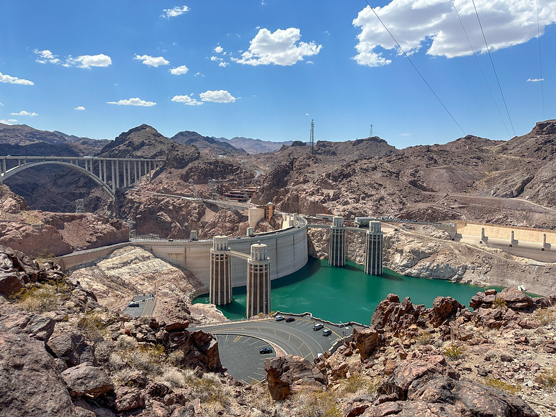
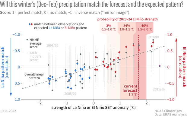
Federal forecasts for the Colorado River’s water supply — the water source for 40 million people — predict a substantial drop as the snow season limps into the new year.
Water flowing into Lake Powell is forecasted to be 79% of its historical average, according to a December monthly report from the U.S. Bureau of Reclamation. One major cause is the poor showing of snow in the Rocky Mountains, but it’s not time to panic yet, water experts say.
Credit: Colorado Basin River Forecast Center
“It’s December, we still have several months of accumulation potential,” said Russ Schumacher, Colorado’s state climatologist. “There’s no reason to freak-out about solely the fact that snowpack is low at this point because there’s still time to make that up. But we also know that, as the climate has been warming, the snowpack that we do get doesn’t go quite as far.”
In the Colorado River Basin, which stretches across seven Western states, a system of reservoirs catches water and meticulously times releases to provide a steady flow to farms, cities, industries and ecosystems around the basin.
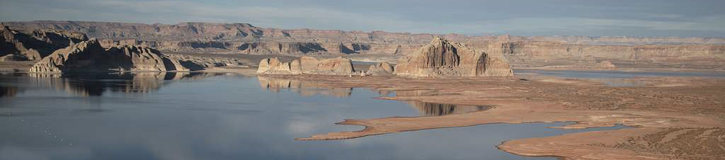
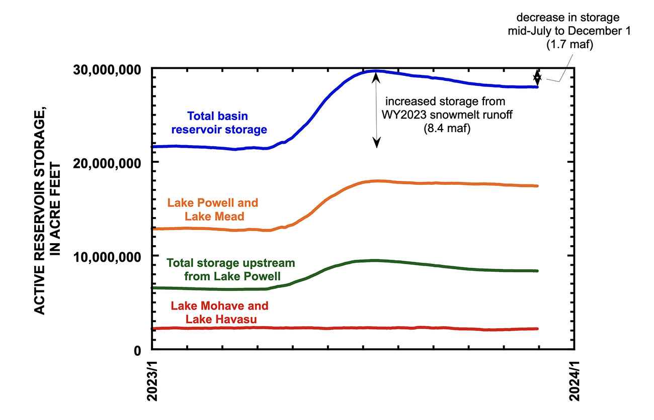
The largest reservoirs are Lake Powell on the Utah-Arizona border and Lake Mead on the Arizona-Nevada border. Together, they can store up to 53.9 million acre-feet of water, or about 92% of the reservoir storage capacity in the entire Colorado River Basin.
Both were drawn down to historic lows in the early 2020s. The good water year in 2023, when the basin saw above-average snow and rain, brought the reservoirs back from the brink of a crisis, but neither is close to its average conditions, let alone near full capacity.
Lake Powell key elevations. Credit: Reclamation
A bad water year — with below-average precipitation and hotter conditions — could send the reservoirs back toward dangerous lows, experts say. At Lake Powell, Glen Canyon Dam can no longer generate hydroelectric power when the water level falls below 3,490 feet or release water at all when the level falls below 3,370 feet.
The outlook for Lake Powell has grown more grim since the start of the water year in October. The Bureau of Reclamation estimated that a total of about 9.4 million acre-feet of water would flow into Lake Powell between October 2023 and September 2024.
That estimate has dropped by nearly 2 million acre-feet. The December forecast estimates the reservoir will receive about 7.62 million acre-feet of water by September, about 79% of the 30-year average from 1991 to 2020.
Two million acre-feet is enough water to fill Blue Mesa twice over — the largest reservoir in Colorado — or to supply one year of water for about 4 million typical urban households.
For reference, last year’s record snowpack sent more than 12 million acre-feet of water into the immense reservoir.
Even with just 7.62 million acre-feet expected to flow into Powell, Glen Canyon Dam is set to release 7.48 million acre-feet of water downstream to Lake Mead, an amount set by interstate agreements that govern how the reservoirs operate.
Graphic via Holly McClelland/High Country News.
Some projections indicate that the reservoir levels could fall low enough to trigger more emergency releases into Lake Powell from Upper Basin reservoirs, like Blue Mesa, which sits on the Gunnison River near the city of Gunnison.
River officials called on Blue Mesa to send water down to Lake Powell in 2021 to boost the reservoir’s water levels. That debt will be repaid by the end of December, said Chuck Cullom, executive director for the Upper Colorado River Commission, an interstate body that helps manage the Colorado River’s water.
“Between now and 2026, I would just highlight for folks that it could be Groundhog Day in the early spring and summer about declining towards critical elevations,” Cullom said during an Upper Colorado River Commission meeting Dec. 13 in Las Vegas.
The accumulation of snow in the mountains of Colorado, Wyoming and Utah provides much of the water for the Colorado River Basin. So far, that snowpack is off to a poor start, Schumacher said.
Federal data shows that the snowpack in the Upper Basin — Colorado, New Mexico, Utah and Wyoming — is the third lowest for the end of December since 1986, he said.
It’s similar to 2018, a year no one wants to repeat in the Southwest, Schumacher said.
“That was a year that started off bad and never recovered,” he said.
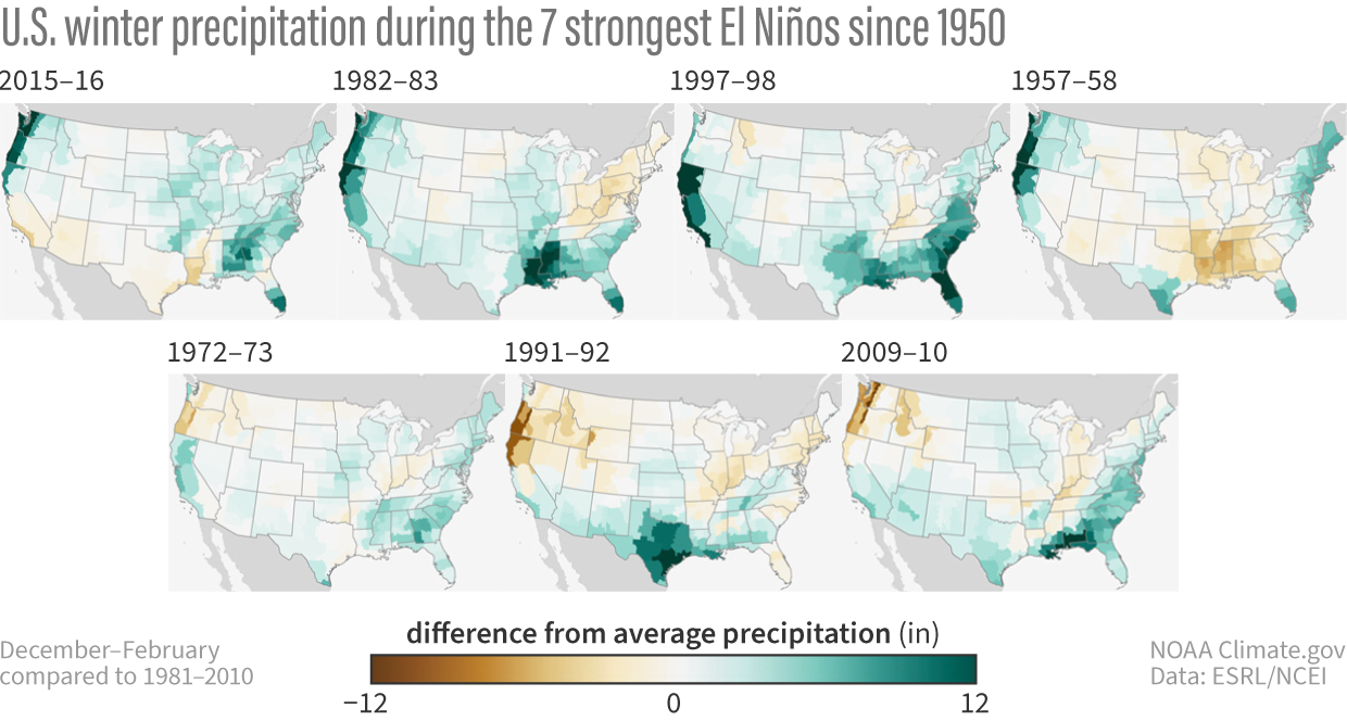
This year, warmer water temperatures in the Pacific Ocean are causing El Niño weather patterns, which normally bring slightly more precipitation to the Southwest and slightly less moisture to the mountains in northern Colorado.
“At this point in the winter, the way bigger uncertainty is that we just don’t know what’s going to happen with the weather for the next few months,” Schumacher said.
More by Shannon MullaneShannon Mullane writes about the Colorado River Basin and Western water issues for The Colorado Sun. She frequently covers water news related to Western tribes, Western Slope and Colorado with an eye on issues related to resource management, the environment and equity. She can be reached at shannon@coloradosun.com.
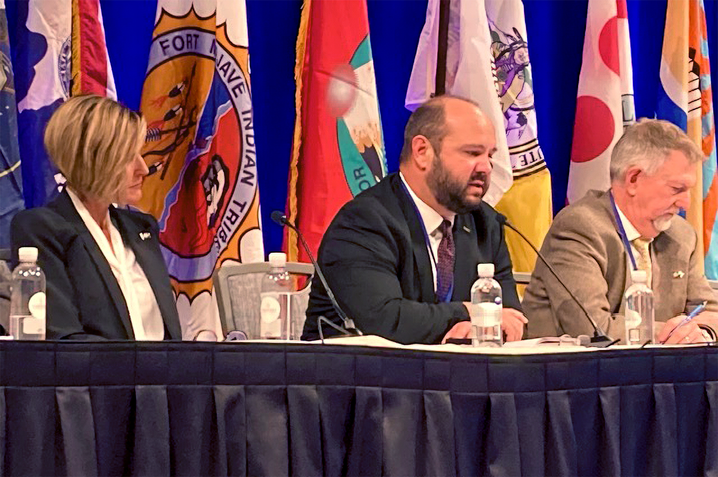
For tribal nations in the Colorado River Basin, repairing a century of exclusion is a crucial step in planning for the river’s future. A new proposal could grant them a permanent seat at the table.
Collectively, the 30 tribal nations in the basin have rights to about 26% of the Colorado River’s average flow, but states and the federal government have repeatedly left them out of major decisions about how the river’s water is stored, divided up and distributed. This month, tribal representatives from around the Colorado River Basin took the mic at the biggest basin gathering of the year with a focus on correcting historical wrongs and asserting their rights to water.
“We are still not directly engaged in the process that determines [the river’s] future,” Amelia Flores, chairwoman of the Colorado River Indian Tribes, four tribes with land in Arizona and California said at the 2023 Colorado River Water Users Association conference in Las Vegas. “… Our livelihoods and our traditions have no voice. We must do better.”
Tribal water concerns have been addressed through legislation, court decisions, contracts and more through the decades. However, tribal leaders say they are informed of decisions about how the river is managed, instead of being included in the decision-making process.
State and federal leaders did not include tribes in the creation of the 1922 Colorado River Compact, which forms the foundation of how the river’s water is managed, despite federal recognition of tribal water rights in years prior. As recently as 2007 and 2019, state and federal partners developed new rules for managing the river in response to prolonged drought, but again, tribes were not included.
As basin officials plan for the river’s future after 2026, when the current rules expire, tribal representatives say history cannot repeat itself. “I’ve heard all the arguments as to why it’s not feasible to have representation of tribes at the negotiation table with the state and federal governments,” Flores said. “I’m not buying it.”
Native America in the Colorado River Basin. Credit: USBR
For the first time, six tribal nations are negotiating an agreement with four basin states and the federal government to give them a permanent voice at one important table. In 2022, tribes with land in the Upper Basin — Colorado, New Mexico, Utah and Wyoming — began meeting with the Upper Colorado River Commission, a governance body made up of federal and Upper Basin state officials.
“This relationship that we’ve formed is very, very important on how the Upper Basin moves as a collective,” said Lorelei Cloud, acting chairwoman of the Southern Ute Indian Tribe, which has land in southwestern Colorado. “We’ve gotten to a point now where we are sharing information with each other, and that’s been monumental.”
The draft agreement would formalize meetings between tribal, state and federal governments, regardless of any future changeover in leadership. The commission will consider and possibly vote on the agreement in February, according to Chuck Cullom, the commission’s executive director, who called the agreement “historic” but overdue. “It’s something we should’ve been doing much earlier,” Cullom said.
The river commission and tribal representatives highlighted the new agreement during a Dec. 13 meeting at the Las Vegas conference. The meeting marked the 75th anniversary of the commission and the second time all six tribes were invited to participate. The first was in 2022.
Tribal representatives from across the basin voiced their main goals and concerns in discussions related to water policy, agriculture and the river’s future at the conference, which brings together all of the key players in the Colorado River Basin each year.
Unused water is a key issue for tribal leaders. About a dozen nations across the Colorado River Basin, including the Ute Mountain Ute Tribe, which also is in southwestern Colorado, still had unquantified water rights as of 2021.
Settling these rights for the Ute Mountain Ute Tribe needs to happen before 2026, Chairman Manuel Heart said. The tribe has completed the legal process to quantify the amount of water tied to its rights in Colorado but not in New Mexico and Utah.
In some cases, tribes may have quantified water rights but lack the infrastructure to deliver it to homes, businesses and farms. Both tribes in Colorado have rights to water they currently can’t access in Lake Nighthorse Reservoir near Durango.
That water flows downstream to Lake Powell and the Lower Basin — where water users can get paid to let it flow by their lands, according to Upper Basin officials. Tribes, however, aren’t compensated for their unused water from settled water rights.
“I’d really like to see full support from all seven states to say yes, we do support tribes,” Heart said. “There’s a lot of water that’s in the basin that’s unaccounted for, that they’re not even compensated for.”
The Upper Colorado River Commission is trying to estimate just how much of this water flows downstream to benefit the Lower Basin, officials said.
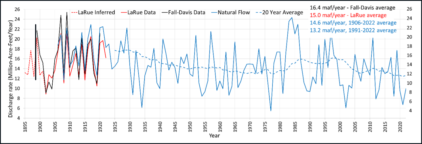
“New plot using the nClimGrid data, which is a better source than PRISM for long-term trends. Of course, the combined reservoir contents increase from last year, but the increase is less than 2011 and looks puny compared to the ‘hole’ in the reservoirs. The blue Loess lines subtly change. Last year those lines ended pointing downwards. This year they end flat-ish. 2023 temps were still above the 20th century average, although close. Another interesting aspect is that the 20C Mean and 21C Mean lines on the individual plots really don’t change much. Finally, the 2023 Natural Flows are almost exactly equal to 2019. (17.678 maf vs 17.672 maf). For all the hoopla about how this was record-setting year, the fact is that this year was significantly less than 2011 (20.159 maf) and no different than 2019” — Brad Udall
“The last 20 years have been really hard for all of us, both Upper and Lower Basin. Every person,” Heart said. “Demand, today, is at a high level. We can’t meet that demand.”
The basin needs to look at new opportunities and partnerships, and work within the limits of the river, several tribal leaders said. “We should all have the fundamental right to access clean water,” Heart said. “We should all have the right to use these waters based on what our needs are.”
Native land loss 1776 to 1930. Credit: Alvin Chang/Ranjani Chakraborty
A man fishes along Blue River. The federal government Dec. 19, 2023, announced a $1.8 million grant for a habitat restoration on a section of the Blue River. Blue River Watershed Group/Courtesy photo
Click the link to read the article on the Summit Daily website (Ryan Spencer). Here’s an excerpt:
December 25, 2023
A tributary of the Colorado River, Summit County’s Blue River has seen fisheries decline due to unnatural conditions associated with the Dillon Reservoir, which provides water to Denver
The federal government earlier this month announced $1.8 million in grant funding for habitat restoration along a stretch of the Blue River downstream from the Dillon Reservoir in Summit County. The funding will support a local environmental group’s efforts to restore Gold Medal fishing on the Blue River, a status the river lost in 2016, according to Blue River Watershed Group advancement director Vanessa Logsdon.
“We’re incredibly excited,” Logsdon said. “This is one of the largest grants we’ve received, and this project is going to be an expensive project. It’s a large area of the river, and it’s basically bank-to-bank restoration.”
Blue River Watershed Group has partnered with Trout Unlimited to create an Integrated Water Management Plan for the Blue River watershed, Logsdon said. A tributary of the Colorado River, “the Blue River faces quite a few threats and issues because of the dam,” she said. On Dec. 19, the Biden Administration’s Department of the Interior announced $1,857,570 in funding to complete the engineering and design for a habitat restoration project laid out in the management plan. The stretch of river where the work will focus is impacted by its proximity to the outflow from the Dillon Reservoir, according to the Interior Department news release announcing the Bureau of Reclamation WaterSMART grant awards. In the Blue River, the dam has contributed to an unnatural flow regime, below-average water temperatures due to cold-water releases from the bottom of the reservoir, and a lack of natural sediment and nutrient transport, the release states. The Integrated Water Management Plan is the culmination of years of scientific studies and research that aims to provide a roadmap for solving environmental issues on the Blue River, Logsdon said. The plan focuses on the stretch of river from its release at the Dillon Reservoir to Columbine Campground north of Silverthorne, she said.
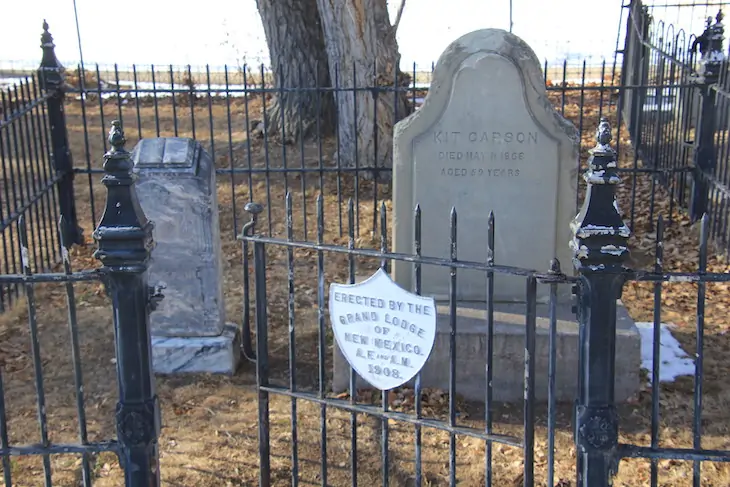
Kit Carson Peak, right, and Challenger, also a 14,000-foot peak, as seen from the area near Moffat, in the San Luis Valley. Photo/Allen Best
Click the link to read the article on the Big Pivots website (Allen Best):
December 24, 2023
It’s called Kit Carson, but a state advisory board in January will review alternatives more acceptable to the Diné and others
My hike up Kit Carson Peak in June 2000 began with great ambition and ended with confusion. Confusion remains now, almost 24 years later, if in a different way. We’re not sure what to call the 14,167-foot summit in the Sangre de Cristo Range.
My 12 hours above treeline that day left me hypoxic, my brain suffering from too little oxygen. I insisted that the route down took us the west side of Willow Lake, but my companions knew better.
Now I contemplate what to call Kit Carson from the floor of the San Luis Valley. A proposal before the Colorado Geographic Naming Advisory Board would have us call it Frustum Peak. A frustum is a flat-topped cone or pyramid.
Still others prefer Crestone, as was considered — but rejected — by a federal board in 2011. Two other 14,000-foot peaks, Crestone Peak and Crestone Needle, lie a short distance away. Three 14ers named Crestone? One stone too many. Other names may yet be considered.
Colorado also has a town and a county named Kit Carson, but neither is up for change as they are not on federal land.
The state advisory board members will resume their discussion on Jan. 24. They will also review alternatives to Garfield County’s Dead Mexican Gulch, Jefferson County’s Redskin Creek and Redskin Mountain, and Montezuma County’s Negro Draw.
Sloans Lake with Mount Blue Sky in the background April 2, 2021.
Whatever they recommend will be just that. The U.S. Board of Geographic Names has final authority for names on federal lands as Colorado seeks to cleanse its geographic drawers of names with tawdry historical footnotes. Earlier this year, the 14er west of Denver gained a new name, Blue Sky. It had been called Evans, after the territorial governor in 1864 who seemingly turned a blind eye to the Sand Creek Massacre.
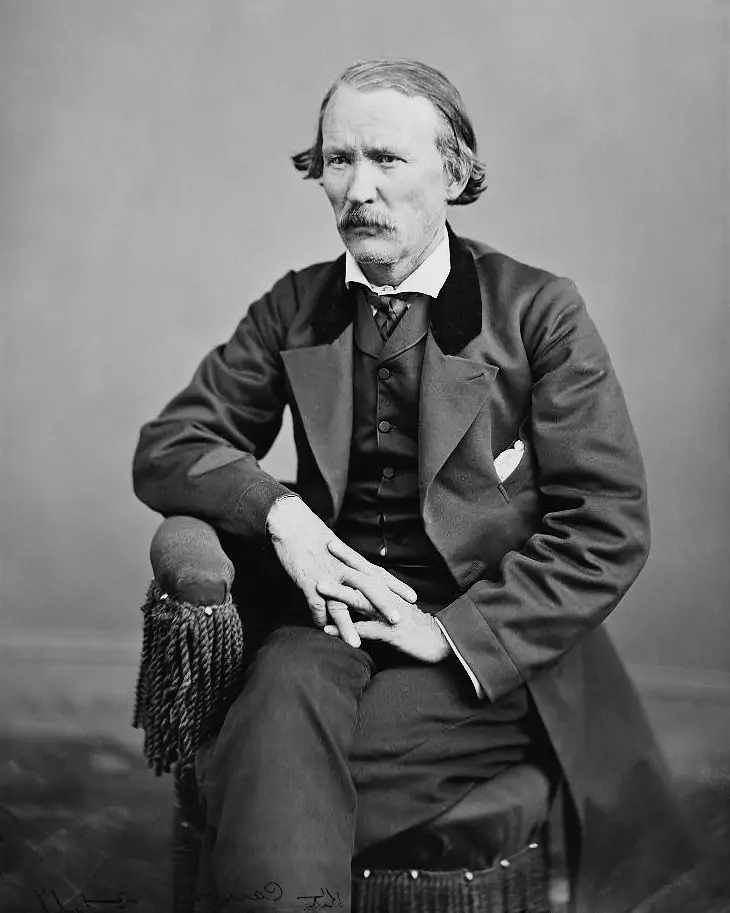
Christopher Houston “Kit” Carson has a more confused and interesting story. Born in Kentucky, reared in Missouri, he fled an apprenticeship in leathermaking for western adventures. As a fur trapper, he was quite successful. He survived.
Like other trappers, he found friends – and foes – among the native Americans, taking two of them as spouses. One called it quits, putting his belongings outside their teepee, as was the custom.
Taos was his favored home. His remains are buried there along with those of Josefa, his final wife. They both died in southeastern Colorado, at Boggsville, near today’s Las Animas. By then, he was General Carson in the U.S. Army.
Kit Carson and his third wife, Josefa, both died in southeastern Colorado but are buried in Taos, which he considered home. Photo credit: Allen Best/Big Pivots
Consult “Blood and Thunder,” by Hampton Sides, for an immensely rewarding read about Carson. Sides acknowledges the complexities of Carson and other frontiersmen. “The mountain men lived with Indians, fought alongside and against them, loved them, married them, buried them, gambled and smoked with them,” he writes.
Trappers unwittingly left a more damning legacy.
“As the forerunners of Western civilization, creeping up the river valleys and across the mountain passes, the trappers brought small pox and typhoid, they brought guns and whiskey and venereal disease, they brought the puzzlement of money and the gleam of steel. And on their liquored breath they whispered the coming of an unimaginable force, of a gathering shadow on the eastern horizon, gorging itself on the continent as it pressed steadily this way.”
That is the conundrum of Carson. It‘s also the question many of us ask ourselves. Will we leave the world a better place – or worse? Or both?
While in the U.S. Army, Carson was responsible for corralling the recalcitrant Navajo, who had long been feared by Spanish, Hispanic and Anglo settlers because of their persistent raiding and sometimes killing. He complained to superiors about the lack of provisions for the Navajo as he marched them to an encampment in eastern New Mexico. Once there, a third died.
Afterward, although gravely ill, Carson accompanied Ute leaders to Washington D.C. at their request to represent them in meetings with President Ulysses Grant and others.
Kit Carson was photographed in 1868 in Washington D.C., shortly before his death in southeastern Colorado at the age of 59. Photo/Wikipedia
His story was complicated.
Carson was mythologized in his own time. Today, we tend to idealize Native Americans even while we fail, in some important ways, to pay them their due, such as their water rights in the Colorado River Basin.
A former newspaper columnist in Colorado Springs responded to my ruminations on Facebook with this: “In our re-naming craze, we should not name anything after humans any more. It turns out that all humans put their pants on one leg at a time.”
Conquerors generally name things in their own honor. Sometimes, we do honor the vanquished. To honor Utes, among Colorado’s 14ers we also have Antero, Shavano, and Tabeguache. We have none to honor Navajos, who call themselves Diné. If they emphatically dislike Kit Carson, so far they have not proposed an replacement.
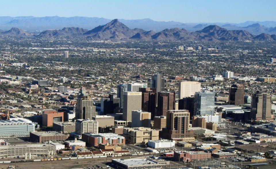
Long-term drought and dwindling Colorado River supplies have Phoenix urgently pursuing highly treated sewage as a drinking water supply. Source: Wikimedia Commons
Phoenix, Southern California betting on purified sewage to fill drinking water needs.
After more than two decades of drought, water utilities serving the largest urban regions in the arid Southwest are embracing a drought-proof source of drinking water long considered a supply of last resort: purified sewage.
Water supplies have tightened to the point that Phoenix and the water supplier for 19 million Southern California residents are racing to adopt an expensive technology called “direct potable reuse” or “advanced purification” to reduce their reliance on imported water from the dwindling Colorado River.
“[Utilities] see that the river is overallocated, and they see that the climate is changing,” said Kathryn Sorensen, former director of Phoenix Water Services Department. “They’re looking at this and understanding that the river supply is highly variable and extremely uncertain in the future.”
The Colorado River that sustains nearly 40 million people and more than 4 million acres of cropland across seven states is shrinking because of climate change and overuse. The river’s flows have declined approximately 20 percent over the past century, and a more than two-decade drought that began at the turn of this century has pushed the system to its limits.
With so much at stake, cities dependent on the river are strengthening water conservation measures and pursuing new sources of water with urgency.
Phoenix is quickly advancing plans to purify its wastewater for household use in the expectation of state regulators’ approval.
The city’s water agency is drafting blueprints, securing funding and crafting communication strategies to assure customers that drinking recycled water is safe and necessary in the face of prolonged droughts and climate change.
Communities in California could see major advances in wastewater reuse in the near future. State regulators on Dec. 19 unanimously approved groundbreaking rules that will allow cities for the first time to pipe highly purified sewage water directly into drinking water supplies.
“This will help the state live up to commitments to reduce our dependency on the Colorado River,” the State Water Resources Control Board chair Joaquin Esquivel said before casting his vote of approval.
Metropolitan Water District of Southern California, which relies on the Colorado River for about 20 percent of its supply, is hoping to launch one of the state’s first direct potable reuse projects. It has plans well underway to build one of the world’s largest wastewater purification plants and expects to release the project’s environmental review next year.
“We can’t be dependent on hydrology, we have to manage our own fate,” said Adel Hagekhalil, Metropolitan’s general manager. “The future is about recycling and reuse.”
At full scale, Metropolitan’s plant would produce 150 million gallons of purified water each day, enough for roughly 400,000 Southern California households.
On Shaky Ground
Finding a new local, reliable water supply is critical for Arizona as more than a third of its water comes from the over-committed Colorado River. The search has become more pressing in recent years as Arizona has sustained cuts to its river supply.
Adel Hagekhalil
Under a drought deal with other states that rely on the river, Arizona this year took a 21 percent reduction – or about six times the amount of water the city of Tucson uses annually – with another round of cuts looming next year.
The inconsistent river supply is a major concern for Phoenix, the state’s most populous city and its capital. Though Arizona farmers and tribes bore the brunt of the recent Colorado River reductions, there’s a chance future cuts will be spread to cities under the next set of river operating rules that take effect in 2027. The revisions are under negotiation by the federal government, Mexico, tribes and the seven Western states that use the river.
The Phoenix metropolitan area has grown rapidly over the last 23 years despite the drought, augmenting its river supply with groundwater. But the underground stores alone won’t sustain the region. Groundwater is also in great demand. Earlier this year Arizona Governor Katie Hobbs halted new permits for homes planned in areas of the state where groundwater is the only source of potable water.
“I will not bury my head in the sand, cut corners, or put short-term interests over the state’s long-term economic growth,” Hobbs said of her decision last June.
A Drought-Proof Source
Phoenix, the nation’s fifth-largest city, believes it can replace some of what it draws from the Colorado River and pumps from underground by recycling water that’s flushed down sinks, showers, toilets and washing machines.
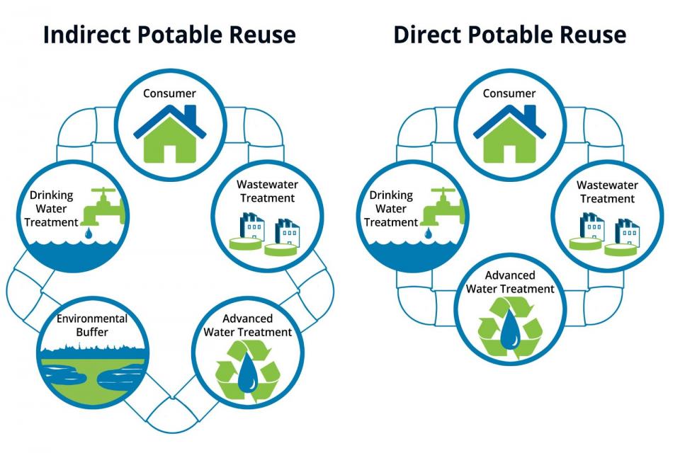
Starting clockwise from the consumer, the diagrams illustrate the conventional (left) and new (right) methods of treating wastewater to drinking water standards. Source: Wikimedia Commons
The allure of direct potable reuse or “advanced water purification,” is its ability to quickly get highly treated wastewater into the drinking water supply. The method treats wastewater through a three-step purification process involving membrane bioreactors, reverse osmosis and ultraviolet light disinfection and adds it to a drinking water source without going through an environmental buffer.
The method also promises to be energy efficient. A 2021 study found that putting recycled water directly into the water supply requires far less power than long-distance water transfers or seawater desalination.
A more widely used water recycling method known as “indirect potable reuse” requires treated wastewater to first go through an environmental barrier such as an aquifer where it is filtered naturally through layers of sand and gravel. The water is then pumped from the ground and treated again before entering the drinking water supply.
Orange County pioneered the technology in the early 1970s to increase its drinking water supply and replenish aquifers along the Southern California coast as a barrier to seawater intrusion. The county water district operates the world’s largest plant of its kind.
Direct potable reuse has been used sparingly in parts of rural Texas, but Phoenix is looking to do it on a mass scale. And the city is wasting little time: The Phoenix City Council recently committed $30 million toward retrofitting a shuttered water recycling operation for advanced purification, even though Arizona regulators have yet to finalize rules for the technology.
Nazario Prieto, assistant director of Phoenix’s wastewater division, said the closed Cave Creek Reclamation Plant in north Phoenix is a perfect candidate for direct potable reuse as it’s near a facility that treats Colorado River water. A short pipeline could connect the two plants, allowing the recycled product to be blended with the Colorado River supply.
“This is going to play a big role in our water resources portfolio, especially with the uncertainty on the Colorado River,” Prieto said. “Water’s precious here in the desert and this is a sustainable resource that keeps coming to us in the form of wastewater.”
Phoenix is also exploring the construction of a larger, regional wastewater plant to serve Scottsdale, Tempe, Glendale, Mesa and other cities in the metropolitan area. A regional plant would be able to treat up to 80 million gallons of effluent per day and if built to full capacity, the regional and Cave Creek plants combined could supply about 20 percent of Phoenix’s yearly potable water needs.
The Arizona Department of Environmental Quality expects to issue final direct potable reuse rules by the end of 2024 and begin accepting applications for permits in 2025. It estimates recycled water could stream out of taps as soon as 2027.
Rendering of Phoenix’s proposed Cave Creek direct potable reuse project. Source: City of Phoenix
The massive wastewater recycling plant proposed for Southern California cities has also gained momentum in recent years due to dry conditions across its two key water sources, the Sierra Nevada and the Colorado River Basin. And Southern California is getting some funding help from its neighbors.
Water agencies in Arizona and Nevada are helping to pay for Metropolitan’s project in exchange for to-be-determined slices of Metropolitan’s Colorado River supply. The proposed plant would be built in Los Angeles and could produce up to 150 million gallons of potable water a day, enough to serve more than 500,000 households.
California’s newly adopted rules on direct potable reuse are expected to take effect in April, following a review by the state Office of Administrative Law. From there, Metropolitan would be able to present its plans to the state water board for approval.
The Yuck Factor
Water agencies are moving swiftly to bolster their scarce Colorado River supplies with recycled water, but first, they must convince customers and politicians that drinking water originating from sewage is safe and worth the treatment cost.
Overcoming the so-called “yuck factor” could be a challenge for some utilities, though a recent direct potable reuse survey by the Arizona Department of Environmental Quality found an appetite for the technology. A strong majority — 70 percent of respondents — said they would be “very likely” or “somewhat likely” to drink recycled wastewater. Some of the more skeptical responses included, “It sounds miraculous, but I would be suspicious,” “How will it taste?,” and “Is it safe for pregnant women?”
Phoenix’s Prieto said the city is crafting a public relations blueprint and giving presentations about the technology to a variety of different business and community groups. He said the initial response has been mostly positive.
“Some people thought we were already doing [direct potable reuse],” he said. “We’re hopeful that we can gain the public’s support and that they will see its safe and the best quality water provided anywhere in the city.”
Beer is another tool being used to overcome the yuck factor.
Lucrative craft beer competitions have been held in Arizona that require participants to use recycled wastewater, while Pima County has created a mobile trailer that treats effluent on site at breweries and provides clean water for brewing. Several Arizona and California breweries are now selling beer made with wastewater.
Kathryn Sorensen
Once Arizona and California approve direct potable reuse regulations, water suppliers will have to figure out how to fund the technology.
Phoenix estimates its Cave Creek project will cost approximately $300 million and that a larger regional plant could cost more than $2 billion.
The final price tag for Metropolitan’s project could top $4 billion by the time it’s finished. Both water suppliers are hoping to tap into state and federal grants to offset some of the cost to their ratepayers.
Major cities are likely to become the first adopters of the technology, but the goal is for rural towns to eventually implement it as well.
Recycled water could be a solution in areas that are burdened by poor groundwater quality or those that don’t have access to surface water. The Arizona Department of Environmental Quality said interest in the technology has broadened to smaller cities.
While adopting the recycling technology isn’t cheap, creating a new water source that alleviates pressure on both the Colorado River and aquifers may be priceless.
“It’s one of the biggest and most important tools,” said Sorensen, who is now director of research at the Kyl Center for Water Policy at Arizona State University. “It is absolutely critical to our water future.”
Know someone who wants to stay connected to water in the West? Encourage them to sign up for Western Water and follow us on Twitter, LinkedIn, Facebook and Instagram.
Elk Creek Marina at Blue Mesa Reservoir on the Gunnison River was temporarily closed so the docks could be moved out into deeper water in 2021 after federal officials made emergency releases from the reservoir to prop up a declining Lake Powell. A state drought task force did not make recommendations regarding an interstate conservation program. CREDIT: HEATHER SACKETT/ASPEN JOURNALISM
Programs that would pay water users to conserve and send that water downstream for the benefit of the Colorado River system remain too controversial for Colorado water managers to agree on.
A statewide task force has failed to make recommendations to lawmakers about the primary issue they were supposed to tackle: how to address drought in the Colorado River basin and respond to a downstream call through water conservation programs.
Senate Bill 295 created the 17-member Colorado River Drought Task Force this year, with representatives from Western Slope water users, Front Range water providers, local governments, the state Department of Natural Resources, environmental groups and tribal leaders. The group met 10 times between July and December at locations across the state and remotely.
According to SB 295, the purpose of the task force was to provide recommendations for state legislation “to develop programs that address drought in the Colorado River basin and interstate commitments related to the Colorado River and its tributaries through the implementation of demand reduction projects and the voluntary and compensated conservation of the waters of the Colorado River and its tributaries.”
But a draft recommendation about what a conservation program should look like lost on a 9-7 vote, meaning task force members did not advance it as a recommendation to legislators. A narrative about the issue was still included in the report.
“I was personally disappointed that some of the larger topics that are out there in the water world or brought up at the task force did not get support from the task force,” said state Sen. Dylan Roberts, a Democrat who represents District 8 and was a sponsor of SB 295. “They either didn’t have time or shied away from those conversations about longer-term solutions.”
The losing recommendation contained many of the state’s same long-discussed themes surrounding demand management: Any potential program should be temporary, voluntary and compensated, should avoid disproportionate impacts to any one region, and must not injure other nonparticipating water rights holders; and Western Slope conservation districts should be involved with projects within their boundaries.
Task force members could not agree on whether the timing was right for such a program, with some saying it’s “premature.” The “no” votes came from those representing Front Range water providers, the Department of Natural Resources, the Department of Agriculture, the Southwestern Water Conservation District and Colorado’s two tribes, the Ute Mountain Ute Tribe and Southern Ute Indian Tribe.
“I think there is a lot of institutional pressure that keeps us tethered to the status quo in water policy in Colorado,” said Roberts, who represents Clear Creek, Eagle, Garfield, Gilpin, Grand, Jackson, Moffat, Rio Blanco, Routt and Summit counties. “We owe it to Coloradans and the people in the West to grapple with the reality of what faces us in the decades ahead. … There’s no time like the present to prepare for a bad situation.”
The lack of recommendations about conservation programs highlights the complicated nature of water in Colorado and the difficulty of achieving consensus among competing interests. A 2021 work group that had been created to tackle speculation also failed to make recommendations to lawmakers.
Water managers say any program designed to conserve water to send downstream to help boost the Colorado River system will likely involve mostly Western Slope agriculture. Members of a state drought task force could not agree on whether the timing was right for a conservation program, with some saying such a program is “premature.” CREDIT: BRENT GARDNER-SMITH/ASPEN JOURNALILSM
Conservation controversy continues
Demand management, water banking, system conservation, a strategic water reserve — the names and details are different, but the basic concept is the same: paying water users to use less on a temporary and voluntary basis. They have been controversial in Colorado, with skeptics saying these types of programs could strip rural agricultural communities of their water.
The Colorado Water Conservation Board undertook its own demand management feasibility investigation in 2019 with eight work groups devoted to exploring different aspects of a potential program. The CWCB shelved the investigation last year without implementing a program.
Some have argued that implementing a state conservation program now would weaken or constrain Colorado’s negotiating position among the six other Colorado River basin states as they hammer out new reservoir operating guidelines. The concern is that implementing a program now would remove the focus from where some say it belongs — that the crisis is driven by overuse in the lower basin. Some task force members said they simply didn’t have enough time to thoroughly discuss conserved consumptive use (CCU) programs.
“Unfortunately, the task force spent very little time discussing this recommendation,” Southwestern Water Conservation District General Manager Steve Wolff wrote in the report. “If we had, we may have been able to develop language that we all could have agreed to and moved a recommendation forward. As written, there are aspects that could not be supported by Southwestern.”
Alexandra Davis, Aurora Water’s deputy director of water resources, served on the task force and voted “no” on the recommendation on conservation programs.
“It’s been contentious,” Davis said. “The CWCB has had a difficult time coming to some sort of idea of what kind of program would benefit the state as a whole and to create sideboards for something that we haven’t been able to agree on yet just seemed premature.”
The Glenwood Springs-based Colorado River Water Conservation District, which recognizes that any CCU program is likely to heavily involve water users within its 15-county Western Slope area, has taken the lead on demand management and system conservation discussions and has commissioned its own studies on the topic in recent years. River District General Manager Andy Mueller wrote the minority report on the task force’s failed recommendation.
“Unfortunately, the task force was unable to provide clear guidance to the members of the General Assembly with respect to how our state should be prepared to move forward should the pressure to participate in an interstate conserved consumptive use program increase in the future,” Mueller wrote. “We respectfully disagree that the CCU proposal is premature, and that this conversation should wait until a specific program is implemented.”
Although the River District does not necessarily endorse a CCU program, officials have repeatedly said they should be prepared with guidelines that protect water users if the state decides to go forward with one and that the River District should be involved to ensure a measure of local control.
“If there are programs that are designed incorrectly, …you will destroy the future of our communities,” Mueller said at the Dec. 7 task force meeting in Denver. “We have seen an interstate water conservation program roll out without any approval by our state legislature or our government and we could see another one come out. … The West Slope will be the target of that produced water.”
Mueller was referring to the Upper Colorado River Commission’s System Conservation Program, which pays water users in the upper basin states — Colorado, New Mexico, Wyoming, Utah — to conserve. The program was rolled out in 2022 without evaluation or approval by the River District.
The Lake Fork Marina boat ramp at Blue Mesa Reservoir on the Gunnison River closed early for the season in 2021 after U.S. Bureau of Reclamation officials made emergency releases from the reservoir to prop up a declining Powell. Members of a statewide drought task force could not agree to advance a recommendation regarding conservation programs to help aid the Colorado River system. CREDIT: HEATHER SACKETT/ASPEN JOURNALISM
12 recommendations
The task force still came up with eight recommendations to legislators, most of which are expansions of or increased funding for existing programs: Continue funding of a technical assistance grant program; increase funding for aging water-related infrastructure; prioritize forest health and wildfire-ready watersheds; expand a temporary loan program to include storage rights; expand agricultural water rights protections beyond divisions 1 and 2 (the South Platte and Arkansas river basins); continue state funding of measurement tools; remove invasive species; and increase funding for municipal turf removal.
A sub-task force on tribal matters made four recommendations: fund a study of a potential pilot program to compensate tribes to not develop their water; have state officials write a letter requesting the U.S. Congress fully fund the Indian Irrigation Fund; waive a requirement for matching funds for state grant programs; and provide cultural protection of instream flows.
Task force Chair Kathy Chandler-Henry — a nonvoting member of the group, the president of the River District board and an Eagle County commissioner — said the time constraints were challenging. Coming up with recommendations in just five months for a field that normally moves at a snail’s pace was hard.
“I think the work that was done in that concentrated period of time is going to bear fruit in ways we don’t know about yet,” she said. “I think that, in itself, is the real value of the task force.”
The Sand Dunes Mushroom Cooperative is the answer that came out of the closure of the Colorado Mushroom Farm
Standing in a cold, unassuming warehouse off Gaumer Lane in Alamosa County, Matias Francisco holds out a handful of soy pellets and a handful of wood pellets. He’s smiling. These little pieces of material are the food and energy for a hidden form of life: mycelium.
The warehouse is bare but insulated on the inside. There are machines wrapped in plastic and some still in their wooden boxes. A hopper is leaned over, already constructed, waiting. Francisco pulls up a hand-drawn blueprint on his phone showing where growing tents will be set up, where the humidifier will sit, and where six or seven – and one day perhaps many more – species of mushrooms will be produced.
Credit: Alamosa Citizen
“There’s a science,” he said. He spends a lot of his time lately researching the best environments to grow organic mushrooms and how to curate an environment that will lead to success.
“It started out really small with an idea….” he said. “We’re learning as we’re going along and learning the ins and outs of the trade. Our goal is to master it and get really good at it.”
Francisco started his career as a coordinator. Working as a migrant coordinator at Adams State University, he eventually found himself working with employees of the mushroom farm. After the farm closed, he ended up being “the mushroom guy” because he knew that there could be solutions through conversations.
Conversations are how this new project got off the ground. This organic mushroom project is more than just creating a new avenue for culinary, beneficial, and most of all, delicious mushrooms. It’s a connection to the community of mushroom growers. People, Francisco says, who are very tuned into the mushroom. The seven families creating this new organic fungus cooperative come from various parts of Mexico and Guatemala.
Mushrooms and their interactions with the people of regions in southern Mexico and many regions in Guatemala can be linked back thousands of years.
Credit: Alamosa Citizen
As people from these regions made their way to the San Luis Valley, which once had one of the largest mushroom operations in the United States, mushroom cultivation was familiar.
At the now-defunct Colorado Mushroom Farm, only three types were grown: portobellos, crimini, and button. They were sold around the state and across the country. When the only mushroom producing plant for hundreds of miles suddenly and quietly closed in September 2022, it left people with a special and unique set of skills and knowledge with hardly any recourse, and certainly without income.
Some 300 families were displaced. A majority, if not all, of the workers at the farm were migrants or were from families of migrants. Many of those people had worked for owner Baljit Nanda for the better part of 30 years. Entire generations worked in the blue-and-white-striped building just northeast of Alamosa.
Now the 10-acre plot of land sits cold and empty, waiting for the completion of bankruptcy court and environmental remediation.
Credit: Matias Francisco
Credit: Matias Francisco
In that midst of insecurity and a total loss of their current way of life, seven families came together and said they could do something with mushrooms that was totally different, completely unique.
Francisco said it was the good result of a bad thing.
The co-op was officially formed on Nov. 28, 2023. It took a year’s worth of work for that alone to happen. There’s a lot of work left to be done, but Francisco says everyone is happy, excited and eager.
On top of learning the business side of cooperative farming, the seven families have been traveling to Bennet and Grand Lake, Colorado, to learn organic cultivation techniques from Sugar Moon Mushrooms and Mystic Mountain Mushrooms.
It started with a survey and a feasibility study. Francisco said the survey took a lot of time, a lot of translation, and a lot of house visits to complete. The survey was to get a sense of what the people wanted to do. Many of them wanted to form a co-op to purchase the old mushroom farm and revitalize it. So the Rocky Mountain Employee Ownership Center came in and conducted a feasibility study to determine if that, in fact, could get done.
“Our program started out as a kind of a hope based off of a migrant coalition meeting we went to. In that coalition, hope was inspired,” Francisco said in an earlier interview.
Through the surveys and study, he said, they were able to make “good, conscious decisions” for figuring out how to get families back on their feet and “to figure out different ways, different avenues on how to grow organic, speciality mushrooms.”
The goal is to serve anything from big shipments to local food hubs. Francisco told The Citizen that a happenstance meeting at the Windsor Hotel in Del Norte resulted in a conversation about how the chefs can get their hands on mushrooms for their menu.
“We’ve come far with this idea. I think the families are excited and we’re learning as we’re going,” he said.
Once they have the operational warehouse, employees are trained, and practices are filed down to the careful science required for fungus cultivation, Francisco says they plan on starting with six to eight species. They’ll start with Chestnuts, Lion’s Mane, King’s Trumpet, Blue Oyster, and a few other unique speciality species. “They’re more unique, they’re not just regular organic mushrooms. Because these mushrooms will be cultivated with love from the people that are wanting to try to tell a story.”
After they fine tune the processes for that, he plans on learning as a group how to farm other mushrooms. What’s more exciting for him, though, he said, was the concept of creating a unique species of mushroom through a liquid culture process.
Alece Montez, co-executive director of the AJL Foundation, a company that’s helping co-op members develop their business, said that because of the love the mushrooms are being cultivated in, it creates an environment that caters to “quality over quantity.”
Credit: Matias Francisco
Credit: Matias FranciscoCredit: Matias Francisco
The timeframe to start full operations is sometime in late spring or early summer of 2024. There is still an overhead capital that is needed to ensure things can operate for some time.
“Finding the funding that will give them the freedom and space to explore and pioneer together and innovate together is really critical without them having to take out loans to do that. It’s really critical that the co-op gets more grants and donations,” Montez said.
She said they are looking at a capital fundraising effort to reach a goal of $1.5 million. Currently, they have earmarked funds that are helping workers to get paid while they train and to set up the operation.
The cooperative, she noted, doesn’t need a space the size of the former mushroom farm. She said the new operation, even as it sits in the final stages of nearing completion, is “much more sustainable. It’s cleaner for the environment and less water intensive.”
Is there pushback from Nanda and the representatives from Rakhra Mushroom Farm?
Montez said there hasn’t been any direct pushback, but she said there is a “sense that somehow this is competitive. If Rakhra opened again they’re gonna be growing such different mushrooms than what the co-op is growing. And the co-op is going about it in a way that the labor … It’s just going to be a physically safer place to be working. Also I think it’s just a more belonging place because it is a co-op.”
Helping hands, voices in direction of the company, collectively working toward improvements and sharing profits are what set the Sand Dunes Mushroom Cooperative apart from the old mushroom farm. “They are all a part of that conversation,” Montez said.
Francisco said that this journey has been all about growth: growth of people and growth of mushrooms.
“This is more than a human effort,” Montez said. “This group is doing a lot to stay together, to work together. It’s a human effort, and I think when you have a lot of families and people together trying to innovate on top of already facing so many barriers that it can be even more difficult when other members of the community have negative things to say…. I think people, naturally it’s very human, to fill in the blanks with stuff that isn’t true or with assumptions.”
Montez said her hope is that the community will see that this is “an effort that will succeed. This is an effort that is meant to bring in more people and to really look out for everyone in the community. This isn’t just a few people trying to do right by their own families. They’re trying to figure this out so that they can make it possible for others to benefit.”
$43.5 million can be used to acquire another property or will be added to the State Land Board Trust’s Permanent Fund that supports K-12 education
When the story of the appraised value of La Jara Reservoir was published, the question readers came back with was ‘So what happens to the $43.5 million?’ which is the revenue the State Land Board would take in from the transfer of land to the U.S. Forest Service and Bureau of Land Management. For that answer we reached out to Kristen Kemp, communications officer for the State Land Board.
“Proceeds of the trust land disposal can only be used in one of two ways: reinvested into the acquisition of another property or deposited into the Trust’s Permanent Fund. Specifically, we have up to two years to use the money to reinvest into the acquisition of another property; at the two-year mark the money must go into the Permanent Fund,” she said of the policy set by the Colorado Legislature.
The State Land Board’s $4-plus billion Trust comprises more than land, she explained. It has four main components: land, mineral estate, commercial real estate, and a $1.4 billion endowment called the Permanent Fund. The interest revenue the state earns from its Permanent Fund is used to support K-12 public education. In FY 22-23, the Permanent Fund generated $40.2 million in interest income, according to the State Land Board annual report.
Kemp earlier explained that the State Land Board “rarely dispose of trust land properties but revenue from ag and recreation leases had not been optimal at the La Jara property.” There are no water rights that transfer with the sale of the La Jara Reservoir to the two federal agencies. Colorado Parks and Recreation is also part of the land exchange.
The distinctive “bathtub ring” around Lake Mead is evident in this view overlooking Las Vegas Boat Harbor and Lake Mead Marina in August 2022. Credit: Christopher Clark/U.S. Bureau of Reclamation, CC BY-SA 2.0
The 1922 Colorado River Compact ignored available science and overallocated the river’s water, a decision whose effects reverberate today. Now there’s an opportunity to get things right.
On 24 November 1922, the Colorado River Commission officially allocated water rights to the seven U.S. states of the Colorado River Basin. The Colorado River Compact and subsequent agreements, collectively known as the Law of the River, eased years of dispute among these states, and they constitute a milestone in the history of the American West.
The 1922 compact provided regulatory certainty for water management. It called for water to be stored and released as needed (most notably with the construction of Hoover Dam), thus supporting a robust era of reservoir building. The reservoirs, in turn, unleashed huge potential for electric power generation and stimulated economic growth throughout the West.
The terms of the compact, however, were largely the product of development aspirations and political dealmaking, and they relied on optimistic estimations of the amount of water the river could supply that were not supported by existing surveys or science. One hundred years later, a lasting water shortage crisis has brought the governance structure outlined in the compact to its knees, and the effects reverberate far beyond the Colorado River Basin. The two largest reservoirs in the United States, Lake Mead and Lake Powell, have reached historic lows, threatening both the water supply and the hydropower generation capacity for tens of millions of users, as well as the nation’s food supply and flows critical to maintaining ecosystems.
This comparison of satellite images of the Glen Canyon–Lake Powell region on the Colorado River shows the dramatic change in water level between 1999 and 2021. Credit: Modified from NASA images
Municipalities are considering drastic water-saving measures. Farmers and ranchers, who as a group are by far the largest consumers of Colorado River water, face unprecedented challenges and uncertainty. So do the economies and environmental systems that depend on reliable stream discharge for aquatic life and recreation.
It is tempting to place responsibility for the water shortages on climate change, which has resulted in reduced precipitation across the basin, and on population growth that outpaced planners’ anticipation of water demands. Indeed, these are important exacerbating factors. A root cause of the dire situation today, however, lies in the commission’s choice to ignore the best available hydrologic science as it negotiated the original compact. As discussions over the availability of Colorado River water continue and a new compact is negotiated over the next few years, planners must not make this mistake again.
The Law of the River
Even before the Colorado River Compact was established, the vast American West was a bustling frontier for mineral exploration, agricultural development, and westward expansion. California already had been diverting water from the Colorado River to irrigate the fertile Imperial Valley since around 1901. Agriculture in sunny but dry southern Arizona was also booming. Other states envisioned securing more water for future irrigation of farmlands and for urban development.
Herbert Hoover presides over the signing of the Colorado River Compact in November 1922. Members of the Colorado River Commission stood together at the signing of the Colorado River Compact on November 24, 1922. The signing took place at the Palace of the Governors in Santa Fe, New Mexico, with Secretary of Commerce Herbert Hoover presiding (seated). (Courtesy U.S. Department of Interior, Bureau of Reclamation)
Members of the commission included eight men, one each representing the Colorado River Basin states—Arizona, California, Colorado, Nevada, New Mexico, Utah, and Wyoming—plus the commission’s chair, Secretary of Commerce Herbert Hoover, who later became president of the United States. All parties realized the paramount importance of agreeing on consistent apportionments of the river’s water to the states, which would provide needed certainty into the future [Kuhn and Fleck, 2019]. That meant estimating the magnitude of the river’s discharge.
The main elements of the compact included the following:
The Colorado River Basin was divided into the Upper and Lower basins at Lee Ferry, Ariz. The Upper Basin includes four states: Colorado, New Mexico, Utah, and Wyoming. The Lower Basin includes three: Arizona, California, and Nevada (Figure 1).
Consumptive water use was divided evenly between the Upper and Lower basins, with each allowed 7.5 million acre-feet (~9.2 billion cubic meters) per year. The Upper Basin states were obligated to “not cause the flow of the river at Lee Ferry to be depleted below an aggregate of 75,000,000 acre-feet for any period of ten consecutive years.”
The river’s average discharge at Lee Ferry was assumed to be 16.4 million acre-feet per year. Allocating a total of 15 million acre-feet per year would leave the remaining water for future development and for Mexico.
Fig. 1. The Colorado River Basin covers parts of seven U.S. states as well as part of Mexico. Credit: U.S. Geological Survey
The allocation of 7.5 million acre-feet per year of consumptive use for each basin was grounded neither in the best available hydrologic calculations nor in climate variability projections. Rather, it was a compromise Hoover proposed between two endmember figures [Kuhn and Fleck, 2019]. One end was 8.2 million acre-feet per year, half the assumed annual average discharge at Lee Ferry of 16.4 million acre-feet per year, which itself was derived from a report by the U.S. Reclamation Service (now the Bureau of Reclamation) [Fall and Davis, 1922]. The other end was 6.5 million acre-feet per year, a figure proposed and advocated by the Upper Basin commissioners that reflected a roughly 50-50 split of the river discharge at Yuma [Kuhn and Fleck, 2019].
In the decades following the 1922 compact, a plethora of acts, orders, and agreements were written and signed to fine-tune the compact’s provisions, to authorize construction of dams for water storage and power generation, to build water transfer infrastructures, and to resolve interstate and intrastate disputes. Particularly significant was the 1944 treaty between the United States and Mexico—still in effect today—that guaranteed 1.5 million acre-feet of Colorado River water annually for Mexico, bringing the total allocation to 16.5 million acre-feet per year.
September 21, 1923, 9:00 a.m. — Colorado River at Lees Ferry. From right bank on line with Klohr’s house and gage house. Old “Dugway” or inclined gage shows to left of gage house. Gage height 11.05′, discharge 27,000 cfs. Lens 16, time =1/25, camera supported. Photo by G.C. Stevens of the USGS.
Source: 1921-1937 Surface Water Records File, Colorado R. @ Lees Ferry, Laguna Niguel Federal Records Center, Accession No. 57-78-0006, Box 2 of 2 , Location No. MB053635.
How Much Water Was There?
In the early 1900s, there were only a few stream gauges in the United States measuring river discharge. The middle section of the Colorado River Basin was one of the most remote and inaccessible regions in the nation at the time. In particular, the canyon region from the mouth of Green River in Utah to the Grand Wash in Arizona, covering a water course of approximately 840 kilometers (520 miles), was accessible to wheeled vehicles at only three points [La Rue et al., 1925]. Because of the inaccessibility, no stream gauges were established there until about 1920. The gauge station at Lee Ferry was established only in summer 1921.
The estimate of Colorado River discharge at Lee Ferry adopted in the compact originated with stream discharge measurements at Laguna Diversion Dam (Figure 2) near Yuma in southern Arizona, a water course of approximately 1,002 kilometers (622 miles) downstream of Lee Ferry. Fall and Davis [1922] derived the value by subtracting the discharge from the Gila River, which enters the Colorado at Yuma, from the measured discharge at Laguna Dam. The commission simply assumed that the volume gained by the Colorado from tributaries between Lee Ferry and Laguna Dam was about the same as the volume lost to evaporation over that same stretch of river corridor (black curve in Figure 2).
Fig. 2. Colorado River discharge at Lee Ferry, Ariz., from 1895 to 2022. From 1895 to 1920, the data show the difference between La Rue et al. [1925] and Fall and Davis [1922] estimates (data are from La Rue et al. [1925, Table 3] and Fall and Davis [1922, Table 6]). The long-term data show the natural discharge and its 20-year running average from 1906 to 2022 (data from U.S. Bureau of Reclamation). Abbreviation maf = million acre-feet.
Even today, it is challenging to estimate water loss due to evaporation and plant transpiration over a vast area of dry land influenced by seasonal floods and varying vegetation covers. It’s clear that the commission’s assumption, and therefore the 16.4-million-acre-feet-per-year estimate, was informed by grossly optimistic considerations and ignored the more conservative science and more reliable hydrologic data available at the time.
A lower estimate of Colorado River discharge had emerged prior to the compact on the basis of a more rigorous scientific approach by U.S. Geological Survey (USGS) hydrologist Eugene Clyde La Rue [Kuhn and Fleck, 2019]. Between 1914 and 1924, La Rue traveled hundreds of miles of the Colorado River and its tributaries to survey dam sites and conduct river discharge measurements. He probably collected more firsthand hydrologic data than anyone and was considered the most knowledgeable Colorado River expert of his generation [Langbein, 1975].
U.S. Geological Survey hydrologist Eugene Clyde La Rue takes notes (top) while in camp on Diamond Creek, a tributary to the Colorado River in Arizona, in 1923. La Rue (bottom; standing in water) measures river discharge along Havasu Creek, another tributary in Arizona, also in 1923. Click image for larger version. Credit: Both: U.S. Geological Survey
La Rue calculated the average discharge at Lee Ferry between 1895 and 1920 to be 15.0 million acre-feet per year using records from stream gauges and tributary contributions upstream of Lee Ferry. Specifically, he used upstream gauges near Green River, Utah, on the Green River and near Fruita, Colo., on the Colorado River (Figure 1), combined with his records from several other tributaries, to estimate the discharge at Lee Ferry (red curve in Figure 2).
How significant is this difference? It represents nearly 10% of the river discharge assumed in 1922, and it is not far below the estimated reduction in demand needed to meet the current shortage. At a U.S. Senate committee hearing in 2022 examining short- and long-term solutions to extreme droughts in the western United States, Bureau of Reclamation commissioner Camille C. Touton testified, on the basis of a bureau analysis, that Colorado River Basin states would need to reduce consumption by 2–4 million acre-feet in 2023 to protect hydropower generation at Lake Mead and Lake Powell.
La Rue argued that decisionmakers should use longer-term averages in estimating river discharge. Prior to 1899, there were no stream discharge measurements in the Colorado River Basin. La Rue creatively used water level records from Great Salt Lake in Utah, calibrated against later records of river discharge and lake levels, to infer earlier annual Colorado River discharges back to 1895 [La Rue and Grover, 1916; La Rue et al., 1925] (dashed red curve in Figure 2). Decades later, La Rue’s inferred discharges for those early years were found to be consistent with discharge values estimated from tree ring studies [Meko et al., 2007]. The different approaches of La Rue and Fall and Davis led to a disparity in their discharge estimates of approximately 1.4 million acre-feet per year.
Ignoring Available Science
Data and science characterizing the Colorado were limited in the 1920s, but La Rue’s river discharge estimate was known ever since he first published it in a USGS report in 1916. Yet his work only hovered in the background of the commission’s negotiations. La Rue made a series of attempts to let the commission know that its perception of how much water was in the river was overly optimistic [Kuhn and Fleck, 2019]. In 1920, he tried but failed to facilitate a meeting between USGS and the Reclamation Service because of his concerns over the difference between his estimate, published in the 1916 USGS report, and Fall and Davis’s estimate, which first appeared in a preliminary Reclamation Service report in 1920.
As the preparation of the compact was gathering steam, La Rue took the unusual step of writing directly to Secretary Hoover. He received only a thank-you note in return. The commission refused to be distracted by any lower estimate of river discharge and forged ahead with the compact based on Fall and Davis’s estimate. The higher estimate, of course, meant more perceived water for everyone, which understandably would make negotiations easier. Whether the commission fully recognized the potential consequences of its inattention to and dismissal of La Rue’s lower estimate at the time is unclear.
Short-Term Measures
In 2007, the Colorado River Basin was experiencing the worst 8-year period of drought in more than a century of continuous recordkeeping. The U.S. Department of the Interior (DOI) issued interim guidelines to address issues related to Lower Basin water shortages and the management of the Lake Mead and Lake Powell reservoirs. These guidelines encouraged voluntary water conservation measures but did not attempt to reallocate water deliveries to compact states.
More than a decade later, as the drought continued, the combined storage in Lake Powell and Lake Mead reached its lowest volume since the 1960s. In 2019, the Bureau of Reclamation then established a Drought Contingency Plan, setting an example of collaboration across the Colorado River Basin. The plan required Upper and Lower basin states to work together to address the imminent water crisis and better manage the Colorado River system in the future.
The Lower Basin approach in the Drought Contingency Plan focused on reducing water demand to stabilize water levels in Lake Mead, while the Upper Basin approach focused similarly on maintaining water levels in Lake Powell. The plan also offered recommendations for voluntary water conservation programs to compensate farmers and other water users for reducing their water use without losing their water rights under the Prior Appropriation doctrine.
In May 2023, DOI announced a deal agreed upon by the three Lower Basin states to conserve at least 3 million acre-feet of water through 2026 to maintain reservoirs above critical levels. Of that amount, 2.3 million acre-feet will be compensated through funding from the Inflation Reduction Act to support water conservation efforts and enhancements to water system efficiency. The remaining conservation needed for sustainable operation will come from voluntary and uncompensated reductions by the Lower Basin states.
Bring Science—and All Parties—to the Table
The interim management guidelines established in 2007 are set to expire in 2026, the date set for review and reauthorization of the 1922 compact. Between now and 2026, there is a window of opportunity to rebalance the allocation and availability of water. It is time to confront the fact that the combination of natural flow and reservoir storage on the Colorado does not provide enough water to meet current demands, as La Rue recognized 100 years ago. It is time to bring science to the negotiating table.
There is no shortage of examples where science has successfully informed water management policy [Loucks, 2021]. Consider the collaboration between Canada and the United States to manage Lake Ontario and the St. Lawrence River. In response to changing needs of various sectors (e.g., recreation, commercial fishing) and natural hydrologic conditions, the International Lake Ontario–St. Lawrence River Board [2006] conducted a comprehensive multiyear study to guide revisions to the existing 50-year-old regulations on water levels and river flows for hydropower generation, river navigation, and flood controls.
The board engaged the public and experts, addressed issues pertinent to affected Indigenous communities as an integral part of the process, and applied state-of-the-art scientific knowledge to inform the discourse over new regulations.
For example, the 2006 study found that shoreline communities preferred lower lake levels, which minimize damages from flooding and erosion, whereas recreational users preferred higher levels. Meanwhile, scientific research considered in the study indicated that widely varying lake levels in the Great Lakes are favorable for healthier ecosystems [e.g., Wilcox et al., 2007]. Together the findings required the board to rethink the interests of shoreline communities and recreational users and of how to maintain reliable water intakes for hydropower. The board then devised regulation options that would benefit a greater number of interest groups than the current regulations did and minimize losses for any single group or geographical area. The study also developed adaptation alternatives to help manage climate change–driven uncertainties in future conditions.
There is no doubt that climate change, droughts, and population growth have exacerbated the Colorado River water shortage crisis. It is also obvious that the best available science was ignored 100 years ago and water from the Colorado River was overallocated. Negotiators today must learn from history and embrace state-of-the-art science to help reallocate the Colorado River sustainably.
Long-term up-to-date natural discharge data at Lee Ferry are available (Figure 2). As of 2022, the 20-year running average stands below 13 million acre-feet per year, a 20% reduction from what was assumed in the original compact. Further decreases are expected.
Milly and Dunne [2020], considering a moderate greenhouse gas emission scenario (i.e., Representative Concentration Pathway 4.5), predicted that average discharge from the Upper Colorado River Basin between 2016 and 2065 could be 5%–24% less than it was in 1903–2017. Miller et al. [2021] projected a 5% decrease at Lee Ferry for the period 2040–2069 relative to 1975–2005. Li and Quiring [2022] projected that discharge in the Upper Colorado River Basin will decrease 2.3%–21.0% due to climate and land use change from 2040 to 2069. The 16.4-million-acre-feet-per-year figure, an overestimate in 1922, is far from realistic today and in the foreseeable future.
In addition to considering the best available science, all stakeholders—notably including those left out of the 1922 compact—must have seats at the negotiating table. Twenty-nine Native American tribes in the Colorado River Basin were granted rights to water for their reservations by the United States Supreme Court in Winters v. United States (1908). And the 1922 compact states: “Nothing in this compact shall be construed as affecting the obligations of the United States of America to Indian tribes.” Yet the agreement made no explicit allocations because tribal representatives were not present during the negotiations, and no subsequent water deliveries were made because there was no infrastructure to convey water to tribal lands.
Formally incorporating tribal water rights is a necessity in the challenge of reallocating the Colorado River. A 2018 study conducted jointly by the Colorado River Basin Ten Tribes Partnership and the Bureau of Reclamation found that the 29 tribes have enforceable rights to as much as 2.8 million acre-feet of Colorado River water per year [U.S. Bureau of Reclamation, 2018], or more than 20% of the 13-million-acre-feet-per-year recent average flow.
Native America in the Colorado River Basin. Credit: USBR
Similarly, the treaty rights of Mexico to Colorado River water also must be included. These rights are mandated by a standing international agreement and are a model for needed bilateral collaboration on allocating the water of the Rio Grande River, which has tributary headwaters in Mexico and the United States.
Realistic Reallocation
Reducing long-term regional allocations will be unpopular, but it is a necessity that negotiators need to accept. The reduced allocations must be embedded in the new compact, and whether as percentages of the natural discharge or of specific volumes, they must be based on robust estimates grounded in the best hydrologic and climate science available.
The total allocation also must account for all stakeholders and reflect expected declines in discharge over the coming decades. Furthermore, decisions and agreements on reallocation should precede regional- and local-scale actions taken to reduce water use, such as conservation, land use changes, water reuse, and water transfers, so that these actions can be implemented according to revised allocations.
Existing tools used to confront the water crisis, which have been used mostly on a volunteer basis and/or on local scales, have achieved limited success, attesting to the difficulty of the choices ahead and to the need for broader, more enforceable regulations. Remembering E. C. La Rue’s science-based approach and thinking long term will bring much to current negotiations and help sensibly reenvision the Colorado River Compact.
Kuhn, E., and J. Fleck (2019), Science Be Dammed: How Ignoring Inconvenient Science Drained the Colorado River, 288 pp., Univ. of Ariz. Press, Tucson.
Langbein, W. B. (1975), L’Affaire LaRue, U.S. Geol. Surv. Water Resour. Div. Bull., April–June, 6–14.
La Rue, E. C., and N. C. Grover (1916), Colorado River and its utilization, U.S. Geol. Surv. Water Supply Pap., 395, 231 pp., https://doi.org/10.3133/wsp395.
La Rue, E. C., H. Work, and N. C. Grover (1925), Water power and flood control of Colorado River below Green River, Utah, U.S. Geol. Surv. Water Supply Pap., 556, 176 pp., https://doi.org/10.3133/wsp556.
Li, Z., and S. M. Quiring (2022), Projection of streamflow change using a time-varying Budyko framework in the contiguous United States, Water Resour. Res., 58(10), e2022WR033016, https://doi.org/10.1029/2022WR033016.
Meko, D. M., et al. (2007), Medieval drought in the upper Colorado River Basin, Geophys. Res. Lett., 34(10), L10705, https://doi.org/10.1029/2007GL029988.
Miller, O. L., et al. (2021), Changing climate drives future streamflow declines and challenges in meeting water demand across the southwestern United States, J. Hydrol. X, 11, 100074, https://doi.org/10.1016/j.hydroa.2021.100074.
Milly, P. C. D., and K. A. Dunne (2020), Colorado River flow dwindles as warming-driven loss of reflective snow energizes evaporation, Science, 367(6483), 1,252–1,255, https://doi.org/10.1126/science.aay9187.
Wilcox, D. A., et al. (2007), Lake-level variability and water availability in the Great Lakes, U.S. Geol. Surv. Circ., 1311, 25 pp., https://doi.org/10.3133/cir1311.
Author Information
Shemin Ge (shemin.ge@colorado.edu) and Joann Silverstein, University of Colorado Boulder; James Eklund, Sherman & Howard LLC, Denver; Patricia Limerick, University of Colorado Boulder; and David Stewart, Stewart Environmental Consulting Group, Fort Collins, Colo.
Citation: Ge, S., J. Silverstein, J. Eklund, P. Limerick, and D. Stewart (2023), Fixing the flawed Colorado River Compact, Eos, 104, https://doi.org/10.1029/2023EO230232. Published on 16 June 2023.
Most Greeley residents’ average monthly utility bill for water, sewer and stormwater services will increase by about $7.84 starting Jan. 1.
The city’s Water and Sewer Board approved new water utility rates for 2024 to support ongoing investments needed to continue providing safe, reliable and great-tasting water, the city announced in a news release.
The city explained the increases with the following breakdown:
$2.53 for water, to support projects for water supply and storage and help fund the location and removal of water service lines that contain lead;
$2.80 for sewer, to ensure compliance with environmental regulations for wastewater treatment;
$2.51 for stormwater, to upgrade storm drains to prevent flooding and protect local rivers.
The estimated increase covers an average-sized house and yard. Factors affecting customers’ individual bills include weather, property size and type of watering.
California’s recent water cuts are a positive sign of cooperation and a step in the right direction, Amy Haas, executive director of the Colorado River Authority of Utah, told The Salt Lake Tribune.
“But one of my concerns, from a Utah perspective, is an over-reliance on compensated conservation,” she said. “This money is going to go away. So, what do we need to do to be prepared for in the way of reductions after 2026? And what happens if some of those reductions are not compensated?”
Haas referred to the Inflation Reduction Act and Bipartisan Infrastructure Law funding. Those laws provided billions of dollars for water infrastructure projects, but eventually, that funding will run out…
“[The water cuts are] predicated on the unspoken assumption that this whole reduction in flows is temporary, that this is a drought and we’re going to get out of it, so let’s just spend some money to overcome it,” Zachary Frankel, executive director of the nonprofit Utah Rivers Council, told The Tribune…
Wednesday’s agreement follows on the heels of a deal made last week between the Biden administration and California’s Imperial Irrigation District, which receives 3.1 million acre-feet of Colorado River water each year. The federal government will send $77.6 million worth of new investments to the district, and the district will cut 100,000 acre-feet of its Colorado River water in 2023.
“At the end of the day, from an Upper Basin standpoint, we’ve got to make sure that conservation is really going to happen,” Haas said.
Lake Powell Photo credit: Center for Colorado River Studies
CPW’s Daniel Cammack, right, and Fred Bunch of Great Sand Dunes National Park transfer Rio Grande chub and sucker captured from Crestone Creek into a holding tank for transport to Big Spring Creek on Sept. 26, 2023 in the San Luis Valley. CPW photos/John Livingston
A decades-long effort to establish new populations of imperiled Rio Grande chub and Rio Grande sucker fish in Colorado’s San Luis Valley led to a historic day on the Medano Ranch of Great Sand Dunes National Park and Preserve.
Colorado Parks and Wildlife (CPW) collaborated with the U.S. Fish and Wildlife Service (USFWS) and National Park Service (NPS) on Sept. 26, 2023 to translocate a population of Rio Grande chub and sucker from Crestone Creek on the Baca National Wildlife Refuge to Big Spring Creek on the Medano Ranch.
More than 600 fish were collected from Crestone Creek and transported to Big Spring Creek, where aquatic biologists hope to create a new self-sustaining population of the native fishes. Currently, there are only seven known self-sustaining populations of Rio Grande sucker in the state.
“This is just a good collaboration between the National Park Service, U.S. Fish and Wildlife Service and CPW and shows good common-sense management to replicate this resource in newly acquired habitat,” said CPW Native Aquatic Species Biologist Daniel Cammack. “Using these fish from Crestone Creek and moving them to a habitat where they are likely to thrive and start another population is a really great effort.”
Rio Grande chub and suckers are currently petitioned to be listed as federally endangered. In Colorado, Rio Grande chubs are listed as a species of special concern and have lost as much as 80% of their historical range within the upper Rio Grande Basin. Rio Grande suckers are a state endangered species, whose occupancy has declined as much as 90%.
The NPS acquisition of Big Spring Creek and the Medano Ranch from The Nature Conservancy presented a unique opportunity to restore these fish to historic habitat in the low gradient creek. The creek is sustained by a perennial supply of spring water that averages 5 cubic feet per second, making it pristine habitat for the native fish species.
Through consistent monitoring of Big Spring Creek, the NPS determined conditions would be suitable for Rio Grande chub and sucker. As soon as it was deemed quality habitat, all three agencies worked together to quickly populate the stream.
“This is a great opportunity to replicate an imperiled population from 20 miles north of us on the Baca Refuge,” said Dewane Mosher, biologist for Great Sand Dunes National Park. “It’s important to secure those genetics from the wild fish here in the National Park.”
Crestone Creek exists on the Baca National Wildlife Refuge, adjacent to Great Sand Dunes National Park and is roughly 20 miles north of the Medano Ranch. Fish were first discovered in Crestone Creek in the early 2000s by Ron Garcia, manager of the Baca Refuge. CPW aquatic biologist John Alves identified the population of fish as Rio Grande chub and sucker, only the second known population of both species that existed at that time.
Since that important discovery, CPW has worked with USFWS to protect and expand the population on the refuge, which is considered one of the most important populations in the species’ range.
“This is an ideal opportunity and it was a historic day to restore some native fish into Big Spring Creek here at the Medano Ranch,” said Fred Bunch, Chief of Resources Management for the Great Sand Dunes National Park and Preserve. “We want to restore endangered species to their habitat. We are very optimistic about their chances of making it here. We want to help these species expand their habitat, and we want to be true to our word and do what we can to help these species.”
The translocation project also allowed CPW and the USFWS to salvage a portion of the population within Crestone Creek. The creek flowing through the Baca Refuge has fluctuating water flows and was running below 1 cfs in September. The Rio Grande chub and suckers occupied small pools where high densities could have led to natural mortality in the winter.
“Historically, Big Spring and Crestone would have been connected here in the Valley and fish may have migrated from one creek to another,” said USFWS Fish Biologist Cole Brittain. “However, with recent drying and lack of water from the abundance of agriculture and ranching related water use, we don’t have those same connections today.
“With the NPS acquiring this property, we can manually transport these fish, and that’s a unique opportunity. This project is 20 years in the making and one we wish we could replicate all over the place, but these properties don’t come by very often. It takes a lot of work from a bunch of agencies.”
Plans are in place to continue introducing more chub and suckers to Big Spring Creek in 2024 utilizing fish from CPW’s John W. Mumma Native Aquatic Species Restoration Facility and additional salvage of wild fish from Crestone Creek as opportunities are presented.
“Past experience with these reintroductions suggests that it can take anywhere from two to five years of stocking before a self-sustaining population is created,” Cammack said. “We will continue to monitor annually, hoping to detect young-of-year fish, providing evidence that natural reproduction is taking place.”
CPW, NPS and USFWS will remain committed to the protection and restoration of these fish to their native range, as projects such as Big Spring Creek align with their shared mission.
“They’re not the species people want to go out and catch on hook and line, but they are an important part of Colorado’s natural legacy,” Cammack said. “They evolved in this landscape, and if you want to consider the environment good as a whole, we want to keep all the pieces. It’s important we not only pay attention to sport fish but also these native species that historically haven’t been managed very well.”
CPW’s Daniel Cammack prepares to insert a pit tag in a Rio Grande chub after collecting it from Crestone Creek on the Baca National Wildlife Refuge. Credit: CPW/John Livingston
Fish are transfered from a net to a bucket to be stocked in Big Spring Creek by CPW’s Rachel Jones.Big Spring Creek flows at 5 cfs through Great Sand Dunes National Park land. Photo credit: CPW/John LivingstonA collection of Rio Grande chub and sucker are pictured in a holding tank ahead of being redistributed in Big Spring Creek. Photo credit: John Livingston/CPWCole Brittain of the USFWS holds a large Rio Grande chub captured in Crestone Creek on the Baca National Wildlife Refuge. The chub was relocated to Big Spring Creek on Great Sand Dunes National Park land. Photo credit: John Livingston/CPW
From left, J.B. Hamby, chair of the Colorado River Board of California, Tom Buschatzke, Arizona Department of Water Resources; Becky Mitchell, Colorado representative to the Upper Colorado River Commission. Hamby and Buschatzke acknowledged during this panel at the Colorado River Water Users Association annual conference that the lower basin must own the structural deficit, something the upper basin has been pushing for for years. CREDIT: TOM YULSMAN/WATER DESK, UNIVERSITY OF COLORADO, BOULDER
Click the link to read the article on the KUNC website (Alex Hager). Here’s an excerpt:
December 15, 2023
The future of the Colorado River is being hashed out behind closed doors, and negotiators appear far from a long-term solution to the wide gap between water supply and water demand. At the Colorado River Water Users Association annual meeting in Las Vegas, representatives from the seven states that use the river spent three days opining on the progress of ongoing talks to determine how water will be managed after 2026, when the current set of rules expires…In a massive ballroom at the Las Vegas Paris Hotel, John Entsminger, Nevada’s top water negotiator, forecasted that the next river-sharing agreement will be “a messy compromise that will be judged harshly by history.” He and delegates from six other states that use water from the Colorado River are trying to agree on a new set of rules for sharing the dwindling supply. The current guidelines expire in 2026. Entsminger said a final agreement may join a patchwork of deals that have incrementally, but perhaps insufficiently, tweaked water use in response to two decades of dry conditions fueled by climate change.
“If you look at the last 25 years of the Colorado River, you know these imperfect, messy compromises step by step by step have gotten us much closer to equilibrium than we were at the turn of the century,” he said…
The structural deficit refers to the consumption by Lower Basin states of more water than enters Lake Mead each year. The deficit, which includes losses from evaporation, is estimated at 1.2 million acre-feet a year. (Image: Central Arizona Project circa 2019)
Some experts rallied for updates to the way water is measured. The Lower Basin states have come under fire for failing to account for “system loss,” or the water lost to evaporation and leaky canals, and critics say the official tally of how much water is in the Colorado River needs to account for that. Those losses total about 1.5 million acre-feet each year, mostly due to evaporation from the surface of Lake Mead, the nation’s largest reservoir. An acre-foot is the amount of water needed to fill one acre of land to a height of one foot. One acre-foot generally provides enough water for one to two households for a year.
“I don’t think the Lower Basin is going to agree to call it what it is, because there are a lot of political and legal issues around it,” said Andy Mueller, general manager of the Colorado River District. “But if they would just permanently reduce their use, including that 1.5 million, I think we’d be a whole lot better off as a system.”
“New plot using the nClimGrid data, which is a better source than PRISM for long-term trends. Of course, the combined reservoir contents increase from last year, but the increase is less than 2011 and looks puny compared to the ‘hole’ in the reservoirs. The blue Loess lines subtly change. Last year those lines ended pointing downwards. This year they end flat-ish. 2023 temps were still above the 20th century average, although close. Another interesting aspect is that the 20C Mean and 21C Mean lines on the individual plots really don’t change much. Finally, the 2023 Natural Flows are almost exactly equal to 2019. (17.678 maf vs 17.672 maf). For all the hoopla about how this was record-setting year, the fact is that this year was significantly less than 2011 (20.159 maf) and no different than 2019” — Brad Udall
The Colorado Department of Agriculture has hired farmer Robert Sakata to serve as the first Agricultural Water Policy Advisor, a position which was created as a result of funding approved during the 2023 legislative session to engage with Colorado farmers and ranchers on water issues affecting agricultural users. He will start in his role effective January 1, 2024.
“I am beyond excited to have Robert joining our CDA team,” said Commissioner of Agriculture Kate Greenberg. “His lifetime of experience in water and as a farmer, his service to the state over many decades serving on related boards and commissions, and his clear commitment to serving Colorado’s agriculture communities make him the right person at the right time. At a time when agricultural producers are facing historic challenges, Robert will bring both empathy and expertise to the table to represent CDA in supporting ag through these challenges. We look forward to seeing all that he will do in this new role.”
Sakata is President of Sakata Farms Inc. in Brighton, Colorado which was started by his father Bob, and currently cares for 2,500 acres of irrigated farm ground between Brighton, Platteville and Hudson. He attended the University of Colorado studying Molecular Cellular & Developmental Biology and child psychology.
Growing up on the family farm, his parents were a great example of how important involvement in the community is. Following their footsteps, Robert is the founding president of the board of directors for the Colorado Fruit & Vegetable Growers Association which was created to fill a need for a common voice representing produce growers across the state.
“Robert brings experience that can only be gained by making a living in irrigated agriculture to this position,” Conservation Services Director Les Owen noted. “This will make him a tremendous asset to CDA in advocating for the agriculture industry on water issues.”
Sakata was appointed by Governor Polis in 2021 to serve on the Colorado Water Conservation Board (CWCB) as a representative of the South Platte Basin. Following the January meeting, Sakata will complete his term and serve as Commissioner Greenberg’s delegate to the CWCB.
Sakata also serves on the boards of the Fulton Irrigation Company, Brighton Ditch Company, and the New Brantner Irrigation Ditch Company. Robert’s past service on organizations include the Metro Basin Roundtable since its inception, the Colorado Water Congress Board of Directors, the National Onion Association Board of Trustees, Adams County Farm Bureau Board of Directors, and Colorado Onion Association Board of Directors.
Sakata served Colorado and worked closely with the Colorado Department of Agriculture for 15 years as a member of the Water Quality Control Commission, having been appointed by three different governors.
In the Fall of 2022, the Colorado Farm Bureau awarded Sakata the “Outside of Farm Bureau Service to Agriculture Award,’ a recognition that his recently passed father received in 2013.
In speaking of public service, Sakata said, “I am honored to be able to participate in water discussions no matter where in order to build trust and foster positive relationships that can carry meaningful dialogue forward.”
El Departamento de Agricultura de Colorado (CDA) ha contratado al agricultor Robert Sakata como el primer asesor de políticas de agua agrícola. El puesto fue creado por la financiación aprobada durante la sesión legislativa de 2023 para trabajar con los agricultores y ganaderos de Colorado en asuntos de agua en la agricultura. Ocupará su cargo a partir del 1 de enero de 2024.
“Estoy super emocionada de tener a Robert en nuestro equipo de CDA,” dijo la Comisionada de Agricultura, Kate Greenberg. “Su experiencia de toda una vida en el sector del agua y como agricultor, su servicio al estado durante muchas décadas en juntas y comisiones relacionadas, y su compromiso total de servir a las comunidades agrícolas de Colorado son reflejantes de una persona perfecta en el momento perfecto. En un tiempo en que productores agrícolas se enfrentan con desafíos históricos, Robert aportará empatía y sabiduría para representar al CDA en el apoyo a la agricultura durante estos tiempos duros. Anticipamos ver todo lo que puede hacer en este nuevo rol.”
Sakata es presidente de Sakata Farms Inc. en Brighton (Colorado), granja fundada por su padre Bob de 2,500 acres de tierras de riego entre Brighton, Platteville y Hudson. Estudió Biología Molecular, Celular y del Desarrollo, y Psicología Infantil en la Universidad de Colorado.
Criado en la granja familiar, sus padres fueron un gran ejemplo de lo importante que es participar en la comunidad. Siguiendo los pasos de sus padres, Robert es el presidente fundador de la junta directiva de la Asociación de Productores de Frutas y Hortalizas de Colorado, que fue creada para dar una voz común y necesaria y representante de los productores de verdura y fruta de todo el estado.
“Robert aporta a este puesto una experiencia que solo puede adquirirse ganándose la vida en la agricultura de riego,” señaló Les Owen, Director de los Servicios de Conservación. “Esto le convertirá en un gran activo para CDA a la hora de defender a la industria agrícola en cuestiones relacionadas con el agua.”
Sakata fue designado por el Gobernador Polis en 2021 para formar parte de la Junta de Conservación del Agua de Colorado (CWCB) como representante de la cuenca de South Platte. Después de la reunión de este enero, Sakata completará su mandato y se desempeñará como delegado de la Comisionada Greenberg ante la CWCB.
Sakata también forma parte de los consejos de Fulton Irrigation Company, Brighton Ditch Company y New Brantner Irrigation Ditch Company. Robert ha trabajado en organizaciones como la Mesa Redonda de la Cuenca Metropolitana desde su creación, la Junta Directiva del Congreso del Agua de Colorado, la Junta Directiva de la Asociación Nacional de Productores de Cebolla, la Junta Directiva de la Oficina Agrícola del condado de Adams y la Junta Directiva de la Asociación de Productores de Cebolla de Colorado.
Sakata sirvió a Colorado y trabajó estrechamente con el Departamento de Agricultura de Colorado durante 15 años como miembro de la Comisión de Control de la Calidad del Agua, habiendo sido nombrado por tres gobernadores diferentes.
En otoño de 2022, el Departamento de Agricultura de Colorado concedió a Sakata el “Premio al Servicio a la Agricultura fuera del Departamento de Agricultura”, un reconocimiento que su padre, recién difunto, recibió en 2013.
Al hablar del servicio público, Sakata señaló, “Es un honor para mí poder participar en debates sobre el agua, dondequiera que sea, con el fin de generar confianza y fomentar relaciones positivas que puedan llevar adelante un diálogo significativo.”
Two and a half years ago, when I was asked to help write the most authoritative report on climate change in the United States, I hesitated. Did we really need another warning of the dire consequences of climate change in this country? The answer, legally, was yes: Congress mandates that the National Climate Assessment be updated every four years or so. But after four previous assessments and six United Nations reports since 1990, I was skeptical that what we needed to address climate change was yet another report. In the end, I said yes, but reluctantly. Frankly, I was sick of admonishing people about how bad things could get. Scientists have raised the alarm over and over again, and still the temperature rises. Extreme events like heat waves, floods and droughts are becoming more severe and frequent, exactly as we predicted they would. We were proved right. It didn’t seem to matter. Our report, which was released on Tuesday [November 14, 2023], contains more dire warnings. There are plenty of new reasons for despair. Thanks to recent scientific advances, we can now link climate change to specific extreme weather disasters, and we have a better understanding of how the feedback loops in the climate system can make warming even worse. We can also now more confidently forecast catastrophic outcomes if global emissions continue on their current trajectory. But to me, the most surprising new finding in the Fifth National Climate Assessment is this: There has been genuine progress, too…
…as we wrote the report, I learned other, even more mind-boggling numbers. In the last decade, the cost of wind energy has declined by 70 percent and solar has declined 90 percent. Renewables now make up 80 percent of new electricity generation capacity. Our country’s greenhouse gas emissions are falling, even as our G.D.P. and population grow…Some politicians now actually campaign on climate change, instead of ignoring or lying about it. Congress passed federal climate legislation — something I’d long regarded as impossible — in 2022 as we turned in the first draft. And while the report stresses the urgency of limiting warming to prevent terrible risks, it has a new message, too: We can do this. We now know how to make the dramatic emissions cuts we’d need to limit warming, and it’s very possible to do this in a way that’s sustainable, healthy and fair. The conversation has moved on, and the role of scientists has changed. We’re not just warning of danger anymore. We’re showing the way to safety.
The reason is that now, we have a better story to tell. The evidence is clear: Responding to climate change will not only create a better world for our children and grandchildren, but it will also make the world better for us right now. Eliminating the sources of greenhouse gas emissions will make our air and water cleaner, our economy stronger and our quality of life better. It could save hundreds of thousands or even millions of lives across the country through air quality benefits alone. Using land more wisely can both limit climate change and protect biodiversity. Climate change most strongly affects communities that get a raw deal in our society: people with low incomes, people of color, children and the elderly. And climate action can be an opportunity to redress legacies of racism, neglect and injustice.
DALL-E thinks we need a very large table for this, suggesting a broad need for “collective agency” to go along with our “collective action” via InkStain (John Fleck).
Click the link to read the article on the InkStain website (John Fleck):
December 20, 2023
The news out of last week’s Colorado River Water Users Association is that, behind the scenes, a deal is taking shape with the potential to bring Colorado River Basin water use into balance with water supply.
The deal would eliminate the “structural deficit”, and creates a framework for a compromise over the Upper Basin’s Lee Ferry delivery/non-depletion obligation.
This is huge. But so are the caveats – in terms of both the challenges remaining for a deal, and the definition of the problem we are trying to solve.
The U.S. Lower Basin states – California, Arizona, and Nevada – have converged on a set of numbers to permanently reduce their use on a year-in, year-out basis by a minimum of 1.25 million acre feet per year, eliminating the “structural deficit” – the year-in, year-out gap between inflows and outflows that has drained Lake Mead over the last two decades.
If separate negotiations with Mexico lead to additional reductions south of the border (which is how this has played out in the last two rounds of basin scheming), total durable, permanent Lower Basin reductions on the order of 1.5 million acre feet a year appear to be within reach.
If more cuts than that are needed to balance the system, the Lower Basin states at CRWUA made it pointedly, publicly clear that they are asking the Upper Basin states to share in the additional pain.
Implicit in that final point is the opportunity for a version of what we used to call the “Grand Bargain” – a Lower Basin concession that the river’s flow may not be sufficient to deliver 82.5 million acre feet per year. That would require even deeper cuts in the Lower Basin. To avoid interstate litigation over a Colorado River Compact delivery shortfall, the Lower Basin is offering a “Modest Bargain” of a sort – an Upper Basin contribution of water matching in some way (it’s not clear in what proportion to the additional Lower Basin cuts) in return for the Lower Basin not wading into a legal fight over the meaning of Article III(d) of the Colorado River Compact.
To the extent that this moves from the meeting rooms and hallway conversations of CRWUA to public view, the seven states need to come together on something that can be put down in writing, publicly, by (I think) March in order for the Bureau of Reclamation wizards to begin the modeling work. So this is on a very fast track.
This is a very big deal, and very good news. But….
SOME TERMS AND CONDITIONS MAY APPLY
There are a bunch of caveats.
The final AZ-CA-NV split of the 1.25-ish million acre feet is not fixed, but it is close, converging on a set of numbers that make sense, respecting some of California’s senior priority status, but not insisting on it as thoroughly as the state’s proposal of last February.
Suffice to say that the remarkable Lower Basin use numbers this year – currently at 5.8 million acre feet for the three U.S. states, the lowest total U.S. draw on Lake Mead since the modern record-keeping regime began in 1964 – shows that cuts like this are totally doable without wrecking the economies of the three states.
If we don’t have three-state numbers yet, we’re a lot farther from figuring out how each of the three states will divvy up the cuts among their users. This will be hard. Well for two of the states, anyway, Nevada just has one major user to do the divvying.
But will voluntary cuts of the scale needed be possible without the big inflow of federal cash that has helped so much this year? The precedent set by all the money sloshing around the Lower Basin right now poses a challenge.
And what of the Upper Basin’s relentless “it’s a Lower Basin over-use problem!” rhetoric over the last year. Now that the Lower Basin folks have basically said “Yup, and here’s what we’re gonna do about that”, have the Upper Basin folks painted themselves into a corner that makes the broader compromise needed on the next steps that much harder?
WHO’S AT THE TABLE RIGHT NOW?
All of this is predicated on a narrow definition of the problem we are trying to solve, which is basically a mass balance problem – figuring out how to match our use of water with the supply available, rather than over-using and draining the reservoirs. This is important! But it’s not the only thing.
This is a process dominated by the economically and politically powerful current water users. If we have a collective action problem here, we also have a “collective agency” problem. It is a system under which “agency” – the power to influence outcomes – is tightly controlled and narrowly distributed.
What about interests other than the big water agencies and their representatives in state government? This is clearly a state-to-state conversation right now, heading toward a desire for a seven-state proposal come March. In the last two rounds of this – the 2007 Interim Guidelines and the Drought Contingency Plan – the states’ proposals have carried the day.
What about the Colorado River Basin’s 30 Tribal Sovereigns? It’s not clear to me how their needs and interests are being incorporated into this process. In this regard, one is reminded of Neil Gorsuch’s dissent in this year’s Navajo decision, where he analogized to the tribe standing in line after line again and again at the DMV, only to be told that this isn’t the right line. Then which is?
What about non-water-consuming environmental values, which have similarly had a hard time figuring out which process might be the right one? The states could, in theory, act on behalf of those non-water agency interests in the deal they’re so furiously negotiating. Will they? Will the federal government step in and insist if the states don’t?
There was hope as we headed into the negotiation of the post-2026 river management regime that broader interests and values would be represented. It will be interesting to see what else beyond a seven-state proposal gets consideration in the discussions to come.
A note on sources and methods: I spent last week resting, looking at art, watching falling snow, reading a book (actually several), and not going to CRWUA. My deep thanks to my many friends who attended and filled me in what they heard and saw. All errors are mine. (Also, is that a Cocker Spaniel in the picture, a couple of seats to the chair’s left?)
The structural deficit refers to the consumption by Lower Basin states of more water than enters Lake Mead each year. The deficit, which includes losses from evaporation, is estimated at 1.2 million acre-feet a year. (Image: Central Arizona Project circa 2019)
Click the link to access the report on the NIDIS website (Britt Parker; Joel Lisonbee, Elizabeth Ossowski ; Holly R. Prendeville; Dennis Todey). Here’s the executive summary:
Over the past few decades, significant advances have been made to improve the Nation’s capacity to proactively manage drought risk by providing those affected with the best available information and resources to diagnose and quantify—or assess—drought conditions. Drought assessments can be a snapshot of present drought severity and extent, an analysis over time of drought duration, a retrospective look at the underlying drivers of a drought, an analysis of the impacts of drought on people or systems, or any other attempt to understand the dynamics of a particular drought. These assessments have a vital role to play in supporting communities in preparing for, mitigating, and responding to drought.
Improvements in data products, more accurate drought assessments, and investments in better coordination have served drought-prone communities well. Continuous integration of new needs and requirements from those communities is essential to maintaining the continuity of progress our country has already made. Today, the changing climate is causing the probability of extreme events to change, a phenomenon known statistically as non-sta-tionarity. In the future, the intensity, duration, and frequency of droughts may change. This poses new challenges that are being raised by scientists, decision-makers, and practitioners. These challenges include the difficulty to distinguish natural variability, meaning the naturally occurring oscillations in the climate system, from forced trends, or the seemingly permanent changes caused by anthropogenic climate change. This also includes the complexity of understanding drought within socio-economic considerations and resource constraints (e.g., funding, capacity) that might limit the ability to integrate the latest science into operational data products.
Around the country, those engaged in drought decision-making are considering a number of questions such as: Do current methods for assessing drought conditions consistently and deliberately consider non-stationarity? If not, could this result in a missed opportunity to promote drought planning and response strategies that build long-term community resilience and reduce risk? What research is needed to produce drought indicators that account for climate change? And what resources are available to support their development and integration into the current suite of indicators?
A technical meeting to discuss this issue was co-hosted by NOAA’s National Integrated Drought Information System (NIDIS) and USDA Climate Hubs on February 28–March 1, 2023, where scientists, decision-makers, and practitioners were asked to address an overarching question: “What approaches should be taken to better incorporate non-stationarity into drought assessment?” Answering this question thoroughly demands thoughtful consideration of (1) the phenomenon of drought itself; (2) the experience of drought and its impacts; (3) the purpose of assessment of drought and its impacts; and (4) the preparation for and response to drought and its impacts, including actions to reduce impacts as well as policies and adaptation. Of these considerations, the technical workshop focused largely on better understanding and assessing the phenomenon itself by breaking the topic down into four sub-topics: (1) considering climate variability and drought assessment; (2) understanding drought in an aridifying (drier-trending) climate; (3) discerning drought in a humidifying (wetter-trending) climate; and (4) defining drought in terms of risk and likelihood of event.
This report captures the ideas and feedback of more than 100 subject matter experts from over 44 institutions across the drought research and practitioner communities who participated in the meeting and reviewed this report. The two-day meeting identified priority actions and outstanding research questions that would continue to advance drought assessment in a changing climate. From the large volume of input received at the meeting, ideas were collated and refined; however, they were not distilled down to a few top priorities, nor were ideas further fleshed out to incorporate a prescriptive scale for implementation. Instead, this report captures the breadth of feedback from the meeting itself.
In total, the report highlights priority actions and research questions across the following fifteen focus areas to improve drought assessment by addressing gaps identified by the research and practitioner community. These fifteen focus areas are presented individually with the acknowledgement that if they are approached as siloes, progress will be curtailed. Many are cross-cutting, progress in one will accelerate progress in another, and it is key that the drought community approach these issues collaboratively. Finally, while the primary focus of the technical working meeting was on better understanding and assessing the phenomenon (of drought) itself, focus areas on related planning, governance, and communication considerations are also critically important and were captured.
Learning with Indigenous Communities
Benchmarking our Understanding and Assessment of Drought in a Changing Climate
Ensuring Equity in Drought Monitoring and Assessment
Evaluating Data Relevance, Fidelity, Integration, Metadata and New Technologies
Determining the Physical Drivers of Drought and How They Are Changing
Understanding Drivers of Aridification and Their Interactions with Drought
Addressing Regional Differences in Non-stationarity
Improving Drought Indicator Performance
Using Precipitation Effectiveness More Broadly to Capture Rainfall Variability
Quantifying Water Demand in a Changing Climate
Evaluating Drought Impacts and How They Are Changing
Assessing Drought in Terms of Risk
Assessing Policy through the Lens of Non-stationarity
Strengthening Planning, Management, and Adaptation
Improving Communication and Collaborative Knowledge Exchange
Across this discussion of diverse and important focus areas, chronic issues emerged that plague our Nation’s efforts to adequately assess drought and its impacts, and these are exacerbated by climate change. These include gaps in drought monitoring and assessment that present equity issues and under-resourced observation and monitoring networks that require additional investment.
This report offers a rich collection of ideas for action and research that federal, tribal, state, local agencies and academic institutions can advance. Further prioritization and specification may be warranted to discern where limited resources might be most impactful, and this will be the focus of an accompanying synthesis paper for publication in 2024. Although the intent of the report is not to provide authoritative guidance or design specifications for specific research or programmatic endeavors, it is intended to illuminate current and future needs to best account for a changing climate in our drought assessment practices.
I was planning for this post to be tip-toeing into a conversation about the prior appropriation doctrine, a conversation which we badly need to have throughout the interior West, but which will likely be vigorously, even violently, opposed by those holding senior water rights in every western watershed.
But instead of that – I’ve been captured by the season, the dark season of long nights and short days that has made us – all the way back to our distant ancestors living in stick-and-mud wickiups (maybe especially them) – want to take a break from the daily round, and instead contemplate the larger problem of helping the sun return. So – a short break here, from worrying about the water we don’t have, or about 2026 and a new set of bandaids and splints for dragging into the future the Marley’s Chain that we call the Law of the River. No big bonfire either, or Saturnalia or Christmas or Kwanzaa just yet, although each in its good time. Instead, just a celebration, or at least acknowledgement, of our currently fading sun – and a revisit to the relationship between the sun and the water that the sun giveth and taketh away, the two things without which we would not be here.
A study by MIT researchers confirms that the planet harbors a “stabilizing feedback” mechanism that acts over hundreds of thousands of years to pull the climate back from the brink, keeping global temperatures within a steady, habitable range. Credits: Image: Christine Daniloff, MIT; NASA
Think, for starters, of the planet misnamed ‘Earth,’ held by the mysterious force of gravity in an uneven circle around the sun at about 66,000 miles per hour, too fast for gravity’s centripetal force to pull it into the sun, but not so fast that centrifugal force would let it leave the sun’s’pull on a straight line into the black night of space – a delicate kind of dynamic balance.
But – ‘Earth’: had we seen it first from above like we can now, from satellites on the upper edge of our atmosphere, we would have called the planet ‘Water,’ or maybe more romantically, ‘Oceania.’ Water covers 70 percent of the planet; we are a planet awash in water. Where the water came from, we can only hypothesize; but we have it – and we are also just the right distance from the sun we circle so that a lot of our water is in its liquid form. A few million miles closer to the sun and our water would be vapor in the atmosphere, as on Venus; a few million miles farther away, and the oceans and land would lie under deep layers of ice – the recent Pleistocene writ larger. But we are in the ‘sweet spot’ between those extremes, where the tilt of the planet is such that in our year’s passage around the sun, most of us are getting a taste of both the water-as-ice world and the water-as-vapor world, winter and summer; but thanks be, water-as-liquid continues to be where, or what, most of the water is.
Diagram credit: USGS
The majority of that water, of course – 97 percent of it – is too salty for land-based life on the 30 percent of the planet currently not underwater. We know that the presence of any water at all on that 30 percent of the planet depends on the sun turning water-as-liquid to water-as-vapor – in effect, ‘desalinating’ it – then wafting some of that cleansed water-as-vapor over the land on winds also generated by the sun, where the water-as-vapor cools as it rises over the land and condenses as precipitation – water-as-ice or water-as-liquid, but either way, what we call ‘freshwater,’ and need more than any other single resource (with the possible exception of the sun).
More than two-thirds of the freshwater that falls over the land gets ‘banked’ on the planet’s remaining glaciers and ice sheets, mostly useless to life. A majority of the remaining third (of just 3 percent of the total water, remember) soaks in as groundwater, some of it ‘tributary’ (eventually working its way underground into streams), and the rest non-tributary (going into ‘deep-storage’ in aquifers). The top layer of water that soaks into the ground is what most of our land-based plants depend on for life and living.
The diminished remainder – less than one percent of all the water on the planet – is surface water: the rivers, streams and lakes we see, use, play in and generally love to death. This is the water that most of the animal life on earth, including us mammals, depend on for life and living. We human mammals, however, have learned how to pump groundwater up to the surface for animal uses.
Sunset over the Yampa River Valley August 25, 2016.
But this is the point at which the sun ceases to be just a good friend. Its propensity for turning water-as-liquid into water-as-vapor does not stop at the edge of the ocean, and as soon as the sun and its agent winds deliver the precipitation to us – mostly water-as-ice in the Colorado River’s mountains – it goes to work converting it back to water-as-vapor.
Western Water Assessment/Nature Conservancy/USDA Snowtography guide cover January 2022.
The sun and wind don’t even wait till the water-as-ice turns to water-as-liquid; the wind goes to work as soon as the snow lands, the sun as soon as the clouds disperse; both sun and wind begin turning an unknown quantity of the water-as-ice directly into water-as-vapor, through the process of sublimation. Only snow that falls on the lee and shaded side of rocks, trees or ridges, or falls through a forest to the ground, is safe from the sun and wind. If it is intercepted on the branches of forest trees, it is sublimated from there too. Estimates of the amount of a snowpack lost to sublimation on exposed areas range as high as 30 percent. Researchers on a large Department of Energy project are making a very complex and instrument-intensive effort to determine more accurately how much is lost to sublimation, and studies are going on in the Western forests to see if there are management strategies that would better protect the snow from sublimation.
The snowpack that survives the winter melts in the spring and early summer, water-as-liquid that either soaks into the ground or runs off in streams, both processes in which its meets other sets of challenges from the sun. The sun that soaks into the ground is eagerly sought out by the roots of plants, and is carried up into their stems, leaves and flowers. There, around 5-10 percent goes into the growth of the plants, and most of the rest is transpired through leaves into the atmosphere as vapor, partly to create a favorable micro-environment around the plant, and – one irrationally suspects – patly because that’s what their lord and master sun wants them to do. (False fact alert.)
The water that runs off, either because the slope is too steep or rocky to soak in or because the ground is already saturated, encounters other challenges. Bouncing down the mountainsides in whitewater streams, dry air catches and vaporizes tiny droplets. Then once the water-as-liquid calms down in the valleys, it encounters lots of users, including us. Much of it is captured by plants, some ‘wild,’ some domesticated, with a large portion of that being transpired back to the atmosphere. Anywhere it is exposed to the sun, some of it is evaporated. In the Colorado River Basin, the water-as-liquid eventually encounters a dam and reservoir, where it becomes a sitting duck for the sun. The hotter the reservoir’s environment, the more is lost – although reservoirs in the upper reaches of the river are only partially exempted from evaporation; they lose water-as-liquid into thinner dry air. Again, we don’t have an accurate measure of evaporation from the sun and its sidekick winds, but estimates I’ve seen are around 800,000 acre-feet in ‘system losses’ (mostly evaporation) from the states above the canyons, and 1.2 million acre-feet system losses from the states below the canyons. Nearly a sixth of the river as it has been running the past 20 years – and those numbers get a little worse in dry years of low precipitation.
Low soil moisture can soak up snow runoff, leaving less for rivers and reservoirs. Image credit: Denver Water.
So the sun giveth and the sun taketh away. A 2022 summary study of Colorado River science cites findings that only 10 percent of the precipitation that falls over the Colorado River Basin actually shows up in the river. A goodly portion of the rest undoubtedly goes to groundwater – but a recent US Geological Survey study (too complex in its science for me to really comprehend) shows that roughly half of the river’s water below the snowpack zone (roughly 8,000 feet elevation and above) is groundwater making its way into the stream. Since about 85 percent of the river’s water originates above the 8,000 foot elevation, the sun clearly does quite a lot of its taking-away before the streams ever emerge in what could be called the human-use region.
There is, however, another co-conspirator with the sun, in determining the ratio of water-as-liquid to water-as-vapor, and that is the planet’s atmosphere – what is in the atmosphere. The atmosphere has a regulatory function for the ratios of water-as-ice to water-as-liquid, and water-as-liquid to water-as-vapor. Small changes in the amount of carbon and nitrogen gases in the atmosphere change those ratios significantly. At the height of the Pleistocene Epoch (most of the past two million years plus) the quantity of carbon gases in the atmosphere had dropped to less than 200 parts per million (ppm), decreasing the capacity of the atmosphere to hold solar heat, and the precipitation that fell as snow and piled up in glaciers in the mountains and ice sheets on the leveler land – ice masses with a weight sufficient to crack and depress the continental crust, leaving depressions that filled up with the Great Lakes when the ice melted.
Sometime in the last half-million years or so, however, something caused the carbon gases in the atmosphere to begin slowly increasing, and the balance of water on earth began to shift back from the cold dry epoch of water-as-ice toward water-as-liquid. Perhaps volcanic activity, perhaps fires in forests dried out for want of water, maybe some assistance from paleo-people burning forests and grasslands to keep forage optimal for the animals they hunted – some combination of factors and events bumped up the carbon gases in the atmosphere to 300 ppm plus or minus, and the planetary climate grew warmer and wetter, mellowing into the Holocene Epoch these past 10,000-15,000 years.
So comparatively mellow was the Holocene, with water-as-liquid replacing water-as-ice in comparative abundance, that all the forms of life that had survived the Pleistocene thrived – thrived so well that many species, plant and animal, experienced episodes of the ‘trauma of success’: outgrowing their resource base in episodes of swarming, and ultimately being brought back into balance through rough action by the rest of their environments, by ‘nature’ – a menu of measures that includes pandemic disease, famine, infighting, social breakdown, and all the other consequences of too many individuals competing for too little food, water, and ‘elbow room.’
We are certainly in that category of swarming species, but are a unique case, being not locked into instinctual behavior, but either blessed or cursed with the capacity to see what’s going on and take steps to adapt culturally, thus avoiding (or at least deferring) the depredations of famine, pandemic disease and war over food, water and land. But our adaptations get ever more complex and difficult to maintain, and usually have unforeseen consequences that have to be dealt with through even more complexity.
Our current success in staying ahead of the disasters that usually brings swarming species back into balance quickly, if brutally, has depended heavily on releasing carbon substances long sequestered in the ground, burning them – and consequently driving up the capacity of the atmosphere to hold the sun’s heat. The good news there is that we’ve probably precluded the usual interstadial return to the Pleistocene winter. But the bad news is that we have begun to significantly increase the conversion of water-as-liquid to water-as-vapor. We’ve all seen the summer virga, when falling precipitation over a desert is evaporated by rising heat before it can get to the ground – beautiful in the desert, but not something we want to see everywhere and all the time….
But time next year for all that. Wishing you all a meaningful and (if it’s not contradictory) joyful holiday season. See you again in 2024 – when we’ll again go down by the river and all its problems (for which a good primer would be to look at the Seven Principles of Kwanzaa).
Moderate or heavy precipitation amounts fell in three main areas this week: central and northern California, parts of the southwestern Great Plains (especially southwest Kansas through the Oklahoma and Texas Panhandles), and along the East Coast. Warmer-than-normal temperatures occurred this week across much of the central and northern contiguous United States. For areas in drought or abnormal dryness that received heavy precipitation amounts, improvements occurred locally due to lessening precipitation deficits and increased streamflow and/or soil moisture. In areas between the southern Great Plains heavy rain and the East Coast heavy rain, deficits in streamflow, soil moisture, and precipitation worsened, leading to widespread degrading conditions. Heavier rains fell on the northeast half of Puerto Rico this week, and scattered moderate drought and abnormal dryness continued on the island. A mix of degradations and improvements occurred in Hawaii this week, with a wet trade wind pattern bringing needed rainfall to windward slopes of Oahu and Molokai. Alaska remained free of drought and abnormal dryness…
In parts of southern Colorado, south-central and eastern Nebraska, and much of Kansas, moderate to heavy precipitation amounts fell this week. Improvements to ongoing drought and abnormal dryness occurred in a north-to-south band across central and western Kansas, where this week’s precipitation lessened precipitation deficits and improved soil moisture. Localized improvements to drought also occurred in south-central Nebraska, where this week’s rain was enough to alleviate precipitation and soil moisture deficits somewhat. Low snowpack and dry conditions for the past few months continued in northern Colorado, leading to a southward expansion of moderate drought and abnormal dryness in high elevations.
The wet weather in southern Colorado led to some improvements to drought conditions. Dryness from the past couple of months increased in eastern South Dakota and in the Black Hills, leading to abnormal dryness expanding or developing in both areas. Temperatures in Nebraska, Colorado, and Kansas were mostly 3 to 9 degrees above normal, with a few local cooler exceptions. In the Dakotas, temperatures ranging from 6 to locally 15 degrees warmer than normal were common…
Colorado Drought Monitor one week change map ending December 19, 2023.
Coastal central and northern California, and parts of the northern Central Valley and northern Sierra Nevada, received heavier precipitation this week, exceeding 2 inches in some places. Lighter precipitation amounts fell in coastal portions of Oregon and Washington. In parts of northern and southeast New Mexico, precipitation this week was enough to improve streamflow, soil moisture and precipitation deficits sufficiently for localized improvements to drought conditions. Short-term drying in parts of east-central Utah led to a small expansion of abnormal dryness. In southwest and south-central Montana, low snowpack amounts, short-term precipitation deficits, and soil moisture deficits led to localized expansion in drought and abnormal dryness. A reassessment of short- and long-term conditions in northwest Montana, the northern Idaho Panhandle, and parts of central and western Washington led to localized improvements to ongoing drought and abnormal dryness…
A soaking rain event occurred this week in parts of the western Great Plains, especially in the Texas and Oklahoma Panhandles and adjacent western Oklahoma and western north Texas. In these areas, precipitation deficits and soil moisture improved enough for widespread improvement to abnormal dryness or drought. Recent rains from before this week led to a reassessment of conditions and some localized improvements in eastern Tennessee. Drier weather occurred in between these locations, with the exception of some rain across Louisiana (which did little to improve the situation but prevented worsening of conditions). Deficits in soil moisture, streamflow, and short- and long-term precipitation continued to locally worsen in northeast Texas, Arkansas, northern Mississippi, and western Tennessee, leading to degrading conditions in some of these areas. Other than parts of Mississippi and Louisiana, most of the region experienced warmer-than-normal temperatures this week, with western Oklahoma and parts of western north Texas and the Texas Panhandle coming in at 4 to 8 degrees above normal…
Looking Ahead
From Wednesday, December 20 to Christmas evening, the National Weather Service Weather Prediction Center is forecasting three areas of heavier precipitation accumulations. The first, where amounts are likely to be between 0.75 to 3 inches of precipitation, is forecast for far western Oregon and Washington. In the Southwest, 0.75 to 2 inches of precipitation is forecast from Arizona into southern California, with higher amounts possible near and northwest of Los Angeles. From the central Gulf Coast northward to the middle Missouri and Mississippi River Valleys, precipitation amounts are forecast to range from a half inch to 2 inches, with locally higher amounts possible from northeast Texas into western Arkansas, and along the Louisiana, Mississippi, and Alabama coasts.
From December 26-30, the NWS Climate Prediction Center forecast favors below-normal precipitation for most of the region from the Mississippi River and Great Lakes west to the Great Basin. Above-normal precipitation is favored along the West and East Coasts and in deep south Texas. Below-normal temperatures are favored in areas near the Louisiana and Texas coasts. Elsewhere, near- or warmer-than-normal temperatures are forecast for much of the rest of the contiguous United States. Except for southwest Alaska, above-normal precipitation is favored for much of the state. Colder-than-normal temperatures are more likely in the western third of Alaska, while the eastern third is more likely to see warmer-than-normal weather. Drier-than-normal weather is favored across Hawaii, and cooler-than-normal temperatures are favored on the Big Island and the eastern half of Maui.
US Drought Monitor one week change map ending December 19, 2023.
Click the link to read the article on the Carbon Brief website (Multiple Authors):
Nearly every country in the world has agreed to “transition away from fossil fuels” – the main driver of climate change – at the COP28 climate summit in Dubai.
It is the first time such an agreement has been reached in 28 years of international climate negotiations.
The commitment is included in the first “global stocktake” of how countries can accelerate action to meet the goals of the landmark Paris Agreement.
However, many countries walked away from the talks frustrated at the lack of a clear call for a fossil-fuel “phase-out” this decade – and at a “litany of loopholes” in the text that might enable the production and consumption of coal, oil and gas to continue.
Despite an early breakthrough on launching a fund to pay for “loss and damage” from climate change, developing countries were left disappointed by a lack of new financial commitments for transitioning away from fossil fuels and adapting to climate impacts.
COP28 president and oil executive Dr Sultan Al Jaber hailed the “world-first” achievement of getting “fossil fuels” in a UN climate change agreement.
However, his presidency was overshadowed by allegations the UAE intended to use COP28 to make oil-and-gas deals.
Away from the negotiations, COP28 brought a wave of new international pledges – covering everything from oil-and-gas company emissions and tripling renewables, through to food systems and how the world can better integrate action on climate change and biodiversity loss.
Here, Carbon Brief provides in-depth analysis of all the key outcomes in Dubai – both inside and outside the COP.
Denver, Colorado, USA – January 12, 2013: The Suncor Energy refinery in Denver, Colorado. Based in Calgary, Alberta, Suncor Energy is a Canadian oil and gas company with revenues of over 35 Billion Canadian Dollars. Photo credit: City of Boulder
From email from CDPHE:
Join the Air Pollution Control Division to discuss further reducing greenhouse gas emissions from oil and gas operations. The division is leading a workgroup that is making a plan to address emissions from the industry’s midstream facilities. Midstream facilities include compressor stations and natural gas processing plants. Fuel combustion equipment at these facilities emit greenhouse gases and other air pollutants. This equipment includes engines, boilers, reboilers, heaters, and turbines.
Public feedback will help the workgroup draft an emissions reduction plan. The draft plan will be open for public comment in 2024. See below for more details and opportunities to comment on the draft plan, once available.
The division invites all Coloradans to participate. In particular, the division would like to hear from:
Communities living or working near midstream oil and gas facilities.
Draft emission reduction plan for oil and gas midstream facilities
Join us in spring 2024 for public meetings on the draft emission reduction plan. The plan will focus on reducing greenhouse gas emissions from midstream oil and gas facilities.
The draft emissions reduction plan will be available on the division’s website. The draft plan will also be open for a 30-day public comment period once available, starting likely in mid-April 2024.
The meeting agenda will include:
An opportunity to provide verbal public comments.
Information on how to submit a written public comment.
Registration is required. Language interpretation services are available upon request.
Registration:
Virtual meeting: Saturday, April 27, 10 a.m. – 12 p.m.
The Colorado Environmental Justice Act set statewide greenhouse gas reduction targets for the industrial sector. This includes reducing greenhouse gas emissions 20% by 2030 below the 2015 baseline for fuel combustion equipment in the oil and gas midstream segment.
Auxiliary aids and services for individuals with disabilities may be provided upon request. Please notify cdphe_apcd_outreach@state.co.us and the Nondiscrimination Coordinator at cdphe_nondiscrimination@state.co.us or 303-692-2102 at least one week prior to the meeting to make arrangements.
From left, Hollie Velasquez Horvath, regional vice president for state affairs and community relations for Xcel, Kathy Chandler-Henry, president of the Colorado River Water Conservation District and Eagle County commissioner and Andy Mueller, general manager of the River District, at the kickoff event Tuesday for the Shoshone Water Right Preservation Campaign in Glenwood Springs. The River District has inked a nearly-$100-million deal to acquire the water rights tied to the Shoshone hydropower plant in Glenwood Canyon. CREDIT: HEATHER SACKETT/ASPEN JOURNALISM
Water managers, state and county elected officials and representatives from environmental and recreation organizations all gathered in Glenwood Springs on Tuesday to mark a historic deal intended to keep water in the Colorado River.
The Glenwood Springs-based Colorado River Water Conservation District has inked a nearly $100 million deal with Xcel Energy to buy one of the oldest and biggest non-consumptive water rights on the main stem of the Colorado River, a first step in ensuring the water continues flowing west.
“How does history feel?” Marc Catlin, vice president of the River District and state Representative from District 58, asked the audience. “Feels pretty good today, doesn’t it?”
At a packed meeting at the Hotel Colorado, River District President and Eagle County Commissioner Kathy Chandler-Henry signed a purchase and sale agreement with Xcel Energy for water rights associated with the Shoshone hydropower plant in Glenwood Canyon. The River District and other partners will pay $98.5 million for two water rights: a 1902 right for 1,250 cubic feet per second and another from 1929 for 158 cfs.
River District board members on Tuesday approved the purchase and sale agreement with Public Service Company of Colorado, a subsidiary of Xcel Energy, and approved spending $20 million from River District’s Community Funding Partnership grant program toward the deal.
The move represents the culmination of years of work on the part of the River District to secure the rights.
“Over the past few decades, 19 western Colorado entities have been working together tirelessly to find a permanent way to preserve these flows, which served as the backbone of western Colorado’s economy and environment,” River District General Manager Andy Mueller said.
Shoshone Falls hydroelectric generation station via USGenWeb
When the Shoshone plant is operating, it draws 1,408 cfs of water downstream, which adds up to about 1 million acre-feet each year, according to the River District. Upstream junior water rights holders, some of which are Front Range diverters that take water from the headwaters across the Continental Divide, must leave enough water in the river for Shoshone to receive its full amount. It also means that the water is available for other downstream users on the Western Slope, including for endangered fish in the critical 15-mile reach of the Colorado River in the Grand Valley.
In recent years, the Shoshone plant has been down often for maintenance and has been damaged or made inaccessible by ice jams, wildfires, rockfall and mudslides in the disaster-prone canyon. A 2016 agreement known as the Shoshone Outage Protocol (SHOP) allows the plant to continue calling for water even when it’s not operable. But SHOP is not permanent, which made Western Slope water managers uneasy. They worried that if Xcel sold or stopped operating the plant permanently, that water would no longer continue flowing downstream or another entity would seek to purchase the water rights.
According to Hollie Velasquez Horvath, regional vice president for state affairs and community relations for Xcel, the River District approached the utility four times about purchasing the rights.
“While we have no plans to not operate the Shoshone plant, we also understand the critical risk if there is ever a point in which that plant does not operate for our customers,” Horvath said. “This deal is important to our customers and I know our communities on the Western Slope.”
Xcel will continue to lease the hydropower rights from the River District for as long as the plant is in operation. The reach where the instream flow rights tied to the deal would be used would run about 2.4 miles from the point of diversion at the Shoshone Dam at the Hanging Lake Tunnel to the outfall of the powerplant penstocks.
Commissioners through whose counties the Colorado River and its tributaries flow — Grand, Summit, Eagle, Garfield, Mesa — each got a few minutes at the podium.
“Grand County is the most heavily diverted … in the state and this is a big deal for us,” said Merrit Linke, commissioner from Grand County, much of whose headwaters are taken eastward to the Front Range. “From tourism to ag and everything in between, Grand County relies on the Colorado and its tributaries. Just to name a few: Williams Fork, Willow Creek, the Fraser, the Muddy, the Blue. For all of those tributaries of the Colorado that flow west, thank you.”
The penstocks and main building at the Shoshone hydropower plant, which is owned by Xcel Energy and uses water diverted from the Colorado River to produce electricity. The plant has often not been operable in recent years because of ice jams, rockslides and wildfires. CREDIT: BRENT GARDNER-SMITH/ASPEN JOURNALISM
Funding needed
According to the purchase and sale agreement, the River District must pay $1 million by Jan. 1, but that is just the start. Closing the deal is contingent on four more conditions that must be fulfilled by the end of 2027: negotiation of an instream flow agreement with the Colorado Water Conservation Board, (the only entity allowed to hold instream flow rights); a change of water right decree that would allow the rights to be used for instream flow in addition to hydropower; approval of the deal by the Colorado Public Utilities Commission; and securing the remaining funding.
The River District has asked the CWCB to contribute $20 million; $10 million is expected to come from the Western Slope coalition, a group including the River District and 18 other local governments and water entities, and the remaining $49 million from the U.S. Bureau of Reclamation through the Inflation Reduction Act that made available $4 billion in funding for drought mitigation.
At Tuesday’s event, which also served as the kick-off for the Shoshone Water Right Preservation Campaign, elected officials vowed to raise their share of the money.
“Garfield County is committed to this project, not only in heart and soul, but in money,” said Garfield County Commissioner John Martin. “We’re going to raise as much as possible and we’re challenging each one of you. … Don’t give me $100, don’t give me $1,000, don’t just give me $1 million.”
State Sen. Dylan Roberts, a Democrat from District 8, which includes Clear Creek, Eagle, Garfield, Gilpin, Grand, Jackson, Moffat, Rio Blanco, Routt and Summit counties, committed to working to secure the funding from the CWCB.
“I applaud you on your excellent work and express my solemn and steadfast commitment to make sure that the state of Colorado does its part in making sure that we can preserve the Shoshone water rights forever,” Roberts said.
Mueller told Aspen Journalism in an earlier interview that securing the Shoshone water rights has been a goal of the River District since the organization’s inception in 1937. He said the deal is a permanent solution to keep water in the river, whose flows have been diminished by drought and climate change.
“While $99 million seems like a lot, in terms of its value to the river and in the communities that depend on it, it’s worth vastly more than that,” he said.
This historical photo shows the penstocks of the Shoshone power plant above the Colorado River. A coalition led by the Colorado River District is seeking to purchase the water rights associated with the plant. Credit: Library of Congress photo
Figure 1. Graph showing reservoir storage in 2023 in three parts of the watershed, as well as the total storage. Note that most of the loss in basin-wide storage was due to decreases in storage upstream from Lake Powell. Credit: Jack Schmidt
Nature offered the Colorado River Basin states a reprieve last winter after a heavy snowpack and generous rainfall saved the region’s two largest reservoirs from collapse.
But one good year won’t solve decades of drought in the West, and the deadline for a new set of rules to manage the Colorado River looms over seven states dependent on its flow.
Top water officials for the seven Colorado River Basin states met last week during this year’s Colorado River Water Users Association conference in Las Vegas. With a few more years of stability secured for the river, state representatives resumed negotiating a new compromise for how they will share — and cut back on — water use after 2026.
States will begin crafting their proposals by March of 2024 before finalizing a new agreement by the 2026 deadline. Negotiators acknowledged they have three options to decide how states will share the river’s waning water supply going forward: litigation, legislation or negotiation.
Negotiations are the preferred option, state water commissioners agreed.
“The only option that reduces the risk to our water users is a consensus solution. Anything else is taken out of our hands, likely by people who understand the situation much less than we do,” said Brandon Gebhart, Wyoming’s river commissioner. “Russian roulette sounds like an interesting, sometimes lucrative game, until it doesn’t work out for you any longer. That’s what the Supreme Court and the Congress is for us.”
The federal government has told states they will need to reduce water use on the Colorado River by 2 million to 4 million acre-feet per year to address the unresolved water shortfall and the effects of climate change. State water commissioners agreed that the longer it takes to compromise and conserve the water needed to keep the river stable, the more likely reservoir levels will continue to plummet, leaving states with fewer and fewer options.
Lake Powell and Lake Mead — the two largest reservoirs in the nation — fell below critical thresholds in 2021 and 2022, triggering emergency cuts and federal action to protect the lakes.
“Tensions are seeping through. That’s good. It should be tense. These are serious things and these are serious people,” said John Entsminger, Nevada’s top water official Thursday.
Those tensions were reflected on the panel as water managers in the Upper Basin — Colorado, New Mexico, Wyoming and Utah — reminded other states that they don’t have structures on the scale of Hoover Dam and Glen Canyon to store their water and can only take what nature gives them.
Entsminger agreed the Lower basin states — Nevada, Arizona, and California — have long failed to live within the means of what the river provides. Year after year, Lower basin states have used nearly all their 7.5 million acre-feet Colorado River allocation compared to the 4.5 million acres-feet used by the upper basin states.
“We can’t accept something that continues to drain the system, that puts 40 million people at risk,” said Colorado’s river commissioner Becky Mitchell.
Lower Basin officials acknowledged that their overuse has outpaced the river’s supply and the need to significantly cut their use.
“There is a supply-demand imbalance in the Lower Basin,” said JB Hamby, California’s top negotiator and vice president of the Imperial Irrigation District. “Where we’re at in the Lower Basin is a recognition that we have to solve and own that supply-demand imbalance. It’s going to be tough. It’s going to be challenging. But it’s absolutely necessary.”
In recent months, California and Arizona have signed conservation agreements with the federal government, made possible thanks to massive federal funding.
During the conference, California water agencies committed to conserve up to 643,000 acre-feet of water through 2025 under an agreement with the federal government, more than double Nevada’s total annual water allocation. Federal water managers also announced they reached an agreement with the Quechan Indian Tribe to save up to 39,000 acre-feet of water in the reservoir through 2025.
Earlier this month, the Imperial Irrigation District — the Colorado River’s largest water user — signed an agreement with the federal government to conserve about 100,000 acre-feet of water in 2023, enough to support upwards of 300,000 single family homes for a year.
Arizona recently pledged to conserve up to 348,680 acre-feet of water in Lake Mead in 2023, and up to 984,429 acre-feet through 2026, in exchange for hefty federal funds.
Lake Mead water users have already conserved up to 348,680-acre feet of water in the reservoir this year— that’s more water than has been conserved in a single year over the past 30 years, according to federal officials.
Water conservation agreements signed this year between the federal government, states, and tribes will conserve more than 1.5 million acre feet through 2026, including up to 984,429-acre feet of water in Lake Mead through 2026.
Still, hydrologists say climate change will require more cuts to water use in the west in order to stabilize the river in the long-term. A Nevada study in 2022 estimated that about 1.5 million acre-feet of water is lost per year because of evaporation and transit loss in the Lower Basin, which remains unaccounted for in official counts.
State water officials say their new reality will only complicate negotiations, but Entsminger said that he still has hope that “compromise on this river system is still possible.”
“The one thing I can tell you with absolute certainty is that the post-2026 guidelines will deliver a messy compromise that will be judged harshly by history. That’s the cold reality,” Entsminger said.
Click the link to read the blog post on the NOAA website (Nat Johnson):
After the lastthreewinters of La Niña conditions (weren’t we all ready for a change!), the tropical Pacific is looking much different this year, with a strong El Niño likely this winter (1). Historically, how has El Niño shaped precipitation (rainfall + snowfall) over the U.S.? Let’s dig in and find out!
What happened during December-February for previous strong El Niños?
For the 7 strongest El Niño events since 1950, wetter-than-normal conditions occurred along the West Coast and southern tier of the U.S., especially in the Southeast. This is expected because El Niño causes the jet stream to shift southward and extend eastward over the southern U.S. However, there are clearly some differences among the events if you look at the details in the maps. For instance, the 2015-16 and 1957-58 strong El Niños were not as wet as expected over the southern U.S. and were even dry in some locations. What is the story there?
U.S. winter (Dec-Feb) precipitation compared to the 1981-2010 average for the past 7 strong El Niño events. Details differ, but most show wetter-than-average conditions across some part of the South. NOAA Climate.gov image, based on data from NOAA Physical Science Lab online tool.
The devil is in the details
When forecasters put together a prediction, one consideration is the forecasts generated by climate models, such as from the North American Multi-Model Ensemble (NMME). You might think that the NMME produces a single forecast map for the upcoming winter, but nope! Each month, the NMME produces hundreds of forecast maps from several different models. Why so many maps? Well, the short version of the story is that the chaos of weather can have big consequences for our seasonal predictions (head over to footnote #2 if you would like a few more details). We cannot possibly say what the weather will be like on January 1st based on model forecasts that were made in early November. So, by running models many times, we are simulating a lot of different possible “weather outcomes” that can occur over a season.
The easiest way to examine these model predictions is not by staring at hundreds of maps (trust me, we’ve tried), but rather by examining the average of all the maps (this is called an “ensemble mean”). The average isolates the seasonal forecast signal (like El Niño) while removing the noise of chaotic weather. This map of forecast averages (3) is shown in the top left panel below, and because we are expecting a strong El Niño this winter, the map, not surprisingly, bears a striking resemblance to the expected winter El Niño precipitation pattern to its right (4).
(top, left to right) The precipitation forecast for this coming winter (Dec-Feb 2023-24) based on the average of all the individual models in the North American Multi-model Ensemble forecast system. The geographic pattern of precipitation we’d expect based on averaging past El Niño winters from 1952-2022. (bottom, left to right) An individual model forecast that is a reasonably good match to the expected pattern. An individual model forecast that deviates significantly from the typical pattern. NOAA Climate.gov image, based on analysis by Nat Johnson.
However, this is a bit misleading because, as just noted, there are actually hundreds of forecasts, and this map is just an average of all of them! We know, because of chaotic weather, that the upcoming reality could more closely mimic any of the hundreds of individual forecasts. And these forecasts can differ considerably from each other.
For example, the map in the bottom left represents one forecast that looks quite similar to the NMME average. On the other hand, the forecast to its right, which was taken from the same model from the same starting month with basically the same El Niño, has almost the opposite pattern! And we cannot rule out either outcome actually happening for the upcoming winter!
This, in a nutshell, is the curse of internal variability. Basically, a single model, run forward with slightly different initial states, can lead to very different forecasted outcomes for the upcoming El Niño winter.
So, what’s the point of making winter predictions?
If I’m basically saying that anything can happen this winter, then why do we bother to produce seasonal predictions? Well, as we have emphasized on the blog, although almost anything can happen in a given winter, El Niño or La Niña can tilt the odds in favor of a particular outcome, meaning that those hundreds of predictions may lean in a certain direction. Additionally, the stronger the El Niño, the more likely the U.S. winter precipitation pattern will match both the average of the computer model forecasts and the typical El Niño precipitation pattern. Because there are higher chances in certain outcomes (e.g., a wetter winter), the presence of El Niño can help users assess risk and make plans.
One way to evaluate forecast skill is pattern matching—an overall correlation “score” that describes how well the actual winter precipitation (such as the precipitation for winter 1997-98, a strong El Niño year, at left) matched individual model forecasts (top right), the NMME average (middle right), or the typical El Niño pattern (lower right). A score of 1 means a perfect match, a score of 0 means no matches at all, and a score of -1 means an inverse match, or a mirror image, such as you might expect to see during a La Niña winter. NOAA Climate.gov image, adapted from original by Michelle L’Heureux and Nat Johnson.
Not convinced yet? We can put my claim to the test by assessing how well the typical or expected El Niño winter precipitation pattern matched up with what actually occurred for past winters. We can do that by examining all previous U.S. precipitation forecasts produced by the NMME, the hundreds of individual forecasts and the multi-model average, for all past winters from 1983-2022. The schematic above breaks down these evaluations.
I have taken every winter precipitation pattern from this period (like the 1997/98 winter pattern shown on the left) and calculated how well that pattern matched the individual NMME forecasts for that winter (top right), the NMME average forecast (middle right), and the expected El Niño precipitation pattern (bottom right) (5). The values in this evaluation (6) range from -1 to +1, with values closer to +1 indicating a good match with the actual observed pattern, values near 0 indicating no match, and negative values closer to -1 indicating an inverse match (“mirror image”). All these calculations for all 40 winters are presented in a single plot and arranged from left to right according to the strength of the La Niña (strongest farthest left) or El Niño (strongest farthest right), as shown in the bottom left of the schematic.
Show me the data!
There’s a lot to take in from these comparisons, but there are three main takeaways. We’ll break it down into a sequence of three steps, starting with a focus on the NMME forecast performance.
Correlations (pattern match “scores”) between forecasts from the North American Multi-model Ensemble (NMME) and observed precipitation for all winters (Dec-Feb) from 1983-2022. Each column shows scores for individual models (small gray dot) and the score for the ensemble average (dark gray dot). Instead of being arranged chronologically, winters are placed from left to right based on the strength of the sea surface temperature (SST) anomaly in the tropical Pacific Niño-3.4 region that winter. Sorting this way shows the overall linear pattern: forecast scores get better (closer to 1, a perfect match) the stronger the La Niña or El Niño. NOAA Climate.gov figure, based on analysis by Nat Johnson.
The first plot in this sequence reveals two of the main takeaways.
The stronger theEl Niño or La Niña, the more likely that the actual winter pattern will match the average model forecast pattern. This is why seasonal predictions work, and why we care so much about ENSO! This point is made by the upward slope of the green dashed line in the figure, which represents the tendency for the average model forecast to perform better at stronger Niño-3.4 index values. In fact, by this metric, the forecasts have performed quite well for most (but not all! – more on that below) moderate-to-strong El Ninos.
For a given winter forecast, chaotic weather causes a wide range of performance among individual model forecasts. This second takeaway, which causes the most wailing and gnashing of teeth among forecasters and their users, is brought out by the vertical stripes that represent the performance from individual model forecasts. In fact, for a given winter, there are usually some forecasts that perform quite well and some that perform quite poorly, even though there are no major differences in the models’ ENSO forecast between the high- and low-performing forecasts. Instead, the main difference is what we saw in those two forecast maps above: unpredictable, chaotic weather. Unfortunately, it’s likely impossible to distinguish those high- and low-performing model forecasts well in advance. Again, that’s the curse of internal variability.
In the second step of this sequence, we now include with red and blue diamonds how well the observed precipitation pattern matched the expected El Niño or La Niña precipitation pattern.
Correlations (pattern match “scores”) between winter (Dec-Feb) precipitation and the geographic pattern we’d expect during El Niño (red diamonds) and La Niña (blue diamonds) based on composites of past events. The overall linear pattern is similar to the pattern shown in the figure above: the match between observations and the expected pattern get better (closer to 1, a perfect match) the stronger the La Niña or El Niño. NOAA Climate.gov figure, based on analysis by Nat Johnson.
This addition reveals the third takeaway.
The average model forecast closely resembles the “expected” El Niño/La Niña precipitation pattern for most winters. This point comes out when we consider that that the dark grey circles representing the average model forecasts, are usually close to the red or blue diamonds that represent the El Niño (right) or La Niña (left) precipitation pattern for a given Niño-3.4 index value. This is the models’ way of agreeing with what we’ve been claiming at the ENSO Blog for years: ENSO is the major player for predictable seasonal climate patterns over the U.S. If there were another more important source of predictability, we would expect a bigger separation between those colored diamonds and the dark grey dots.
The comparison between the two biggest previous El Niños in this record, the winter of 1997/98 (a forecast success) and 2015/16 (widely regarded as a forecast “bust,” or how forecasters generally describe a bad forecast), are a great illustration of this final point. Check out footnote #7 for the details, but the upshot is that the influence of chaotic weather variability could have reduced the 1997/98 forecast performance much more than it did, and it likely was a factor in why the 2015/16 forecast performed so much worse.
Finally, let’s put these comparisons in the context of the forecast for the upcoming winter.
Two kinds of correlation scores: gray dots show how well the NMME forecasts (light gray dot=individual models, dark gray=average) matched actual winter precipitation; diamonds show how well the observed precipitation matched the geographic pattern we’d expect from averaging past La Niña (blue) or El Niño (blue) winters. The overall linear pattern is similar for both: pattern matches get better (closer to 1, a perfect match) the stronger the La Niña or El Niño. This winter’s forecast for a strong El Niño means the winter has a higher chance of matching—on average for the U.S.—the typical El Niño pattern. NOAA Climate.gov figure, based on analysis by Nat Johnson.
The likelihood of a strong El Niño increases the chance that the precipitation pattern for the upcoming winter will match both the NMME average and the expected El Niño pattern reasonably well, but, as I have been emphasizing, we cannot rule out the possibility that reality will have other plans.
That’s awfully convenient!
At this point, you might be saying, “Hold on, Nat, you’re telling me that ENSO is the main driver of the winter precipitation outlook, and if it busts, we can just blame it on the noise of chaotic, unpredictable weather? That sounds like a cop-out (and a little suspicious coming from a writer for the ENSO Blog).” That’s a fair question! As scientists, we need to continuously reevaluate our assumptions, check for blind spots, and tirelessly strive to improve our understanding of our forecast models. I can assure you that these efforts are being made, especially when the seasonal conditions deviate from expectations, and hopefully they will lead to better seasonal predictions with higher probabilities.
The main point I’m trying to make, however, is that when a forecast busts, it isn’t necessarily because there is a clear reason, a model bug, or a misunderstanding of the drivers. It could just be because there is a certain amount of unpredictable chaotic weather that we cannot predict in advance. That means that we must remember that seasonal outlooks are always expressed as probabilities (no guarantees!) and that we need to play the long game when evaluating seasonal outlooks – a single success or bust is not nearly enough.
The official CPC seasonal outlook for this upcoming 2023-24 winter has been updated and you can find it here. We need to keep in mind that other climate phenomena (e.g., MJO, polar vortex) that could shape conditions this winter are mostly unpredictable for seasonal averages, but are more predictable on the weekly to monthly time horizons (8). That means you may want to consider shorter-range forecasts, like CPC’s Monthly, Week 3-4, 8 to 14 Day, and 6 to 10 Day outlooks. We at the ENSO Blog will be closely monitoring how conditions evolve this winter, and we’ll be sure to keep you updated!
Footnotes
Following the description in Emily’s post, we consider El Niño to be strong when the Oceanic Niño Index for the season exceeds 1.5° C. As of CPC’s November ENSO forecast update, the probability that the Oceanic Niño Index will exceed 1.5° C for December – February 2023/24 is 73%.
One of the main sources of uncertainty in our seasonal predictions stems from the state of our climate system (ocean, land, and atmosphere) at the start of a forecast (“initial conditions”). Why does this matter? Well, we do not perfectly observe and understand the current oceanic, land, and atmospheric conditions over the entire globe at any single moment in time. Because of this uncertainty at the very start of a forecast, we run prediction models from slightly different starting conditions, making hundreds of different predictions at any one time (“an ensemble of many different members”). Those tiny differences in starting conditions can lead to very distinct seasonal predictions through the chaos of weather (as Emily wrote, think of a difference equating to a flap of a butterfly’s wings in Brazil at the start of a forecast leading to a tornado forming in Texas several weeks later). Another source of uncertainty is the imperfect way that climate models represent physical processes relevant for our weather and climate. Although that is not the focus of this post, it’s the main reason why the NMME is a combination of many different models – the multi-model average tends to filter out the errors of individual models and produce a more accurate forecast.
Specifically, I averaged all the forecasts produced in September, October, and November of this year from 7 different models. Each model has a set of forecasts (ranging from 10 to 30) with slightly different initial conditions to sample the different possible realizations of chaotic weather variability. By taking the average of all forecasts, we tend to average out the effects of chaotic weather variability and isolate the predictable seasonal forecast signal. The NMME precipitation map was produced by averaging 324 individual forecast maps (108 for each of September, October, and November). You might ask, why don’t I just use the latest (November) forecast? Well, the more maps that I average, the more I can average out that chaotic weather and perhaps some of the individual model errors. It turns out that the average of these three months produces a precipitation forecast that performs slightly better than the November forecast.
I calculated the “typical winter El Niño precipitation pattern” as the linear regression of December-February precipitation anomalies on the Niño-3.4 index from 1952-2022. Because of the method that was used, we can just flip the sign of the precipitation anomalies in the map to get the “typical winter La Niña precipitation pattern.” The map is scaled by the December-February Niño-3.4 index, so we would multiply this map by the Niño-3.4 index to get the expected precipitation anomaly amplitudes for that winter (i.e., the stronger the El Niño, the stronger the expected precipitation anomalies).
If the Niño-3.4 index was less than zero for that winter, then the forecast would be compared with the expected La Niña precipitation pattern, which would be the same spatial pattern as the El Niño pattern but with anomalies of opposite sign. The method for calculating this pattern is described in the previous footnote.
Specifically, I am evaluating the forecasts with a pattern correlation, which is a metric we have used before on the blog (like here).
The U.S. precipitation pattern correlation analysis shows that the average 1997/98 NMME forecast, which featured a classic El Niño precipitation pattern, performed very well (pattern correlation exceeding 0.8, as shown in the schematic) and likely helped to shape expectations for the major El Niño that occurred in 2015/16. The precipitation pattern in 2015/16, however, didn’t materialize as expected, especially in California, and that winter precipitation forecast was widely panned as a bust for that region.The analysis confirms that the average NMME forecast in 2015/16, which again resembled the classic El Niño pattern, performed unusually poorly for a strong El Niño, with a pattern correlation near zero. There are many studies that have attempted to address what contributed to the unusual pattern in 2015/16, but this figure reveals that chaotic weather may have been a major factor. In particular, we see that many individual forecasts in 2015/16 performed much better than the average (check out some of the individual forecasts with pattern correlations greater than 0.5), even better than many individual forecasts in 1997/98. This suggests that the influence of chaotic weather variability did not harm the 1997/98 forecast nearly as much as it could have, but it likely was a factor in why the 2015/16 forecast performed so much worse.For a very good detailed and technical discussion on the challenges of seasonal precipitation prediction over California, I recommend Kumar and Chen (2020). Also, check out Tom’s previous post on the topic.
Releases from the Aspinall Unit will be decreased from 650 cfs to 575 cfs on Wednesday, December 20th. Releases are being decreased in response to drier than average conditions in the Gunnison Basin.
Flows in the lower Gunnison River are currently above the baseflow target of 1050 cfs. River flows are expected to remain above the baseflow target for the foreseeable future.
Pursuant to the Aspinall Unit Operations Record of Decision (ROD), the baseflow target in the lower Gunnison River, as measured at the Whitewater gage, will be 1050 cfs for December.
Currently, Gunnison Tunnel diversions are 0 cfs and flows in the Gunnison River through the Black Canyon are around 620 cfs. After this release change Gunnison Tunnel diversions will still be 0 cfs and flows in the Gunnison River through the Black Canyon will be near 550 cfs. Current flow information is obtained from provisional data that may undergo revision subsequent to review.
An essential part of knowing where you’re going is having a solid understanding of where you’ve been.
That’s no less true for the future of the Colorado River system – one of the most complex managed waterways in the world – than it is for anything else.
At the Colorado River Water Users Association’s annual end-of-year conference, a panel of river experts on Wednesday summarized and analyzed the sometimes-positive, sometimes not-so-positive recent history of the river.
The panelists of “A Site Review: Effectiveness of Current and Past Programs” included:
Summarizing the status of the river system today, Eric Kuhn of Colorado observed that the 2023 winter snowpack season in his state “is off to an uninspiring start.”
He observed that Colorado snowpack today stands at about 60 percent of normal. The next 24-month study of river conditions, produced by the Bureau of Reclamation, could show a river-production drop of 1 million acre-feet from previous expectations, he said.
David Palumbo of the Bureau discussed the wide range of federal programs that are being implemented currently, many of them dedicated to conserving water in the river system.
The now-famous “2007 Interim Guidelines,” which set guidelines for shortages that each Lower Basin state would take in the event of delivery shortfalls, “were fundamental to the operation of the Colorado River,” he said.
Although those ’07 Guidelines proved insufficient for keeping the river system reservoirs from descending to critical surface levels, they were “rooted in the best available guidelines that we had at the time.”
Amy Haas of Utah recalled the history of the 2019 Drought Contingency Plannegotiations – the second great collaborative effort by Colorado River user-states to protect the system.
Patrick Dent of the Central Arizona Water Conservation District – operators of the Central Arizona Project canal system – observed the substantial increases in conservation efforts over the years. Conservation in 2014 by the Colorado River states amounted to less than 1 million acre-feet.
Slides from the panel discussion. Credit: Arizona Department of Water Resources
By 2023, however, the amount conserved to protect the system shot up to 6.93 million acre-feet. That staggering conservation figure, he noted, Intentionally Created Surplus water stored by the United States; contributions stipulated in the 2019 Drought Contingency Plan; system conservation efforts and other conservation efforts, as well as water saved under the terms of the ’07 Guidelines.
“New plot using the nClimGrid data, which is a better source than PRISM for long-term trends. Of course, the combined reservoir contents increase from last year, but the increase is less than 2011 and looks puny compared to the ‘hole’ in the reservoirs. The blue Loess lines subtly change. Last year those lines ended pointing downwards. This year they end flat-ish. 2023 temps were still above the 20th century average, although close. Another interesting aspect is that the 20C Mean and 21C Mean lines on the individual plots really don’t change much. Finally, the 2023 Natural Flows are almost exactly equal to 2019. (17.678 maf vs 17.672 maf). For all the hoopla about how this was record-setting year, the fact is that this year was significantly less than 2011 (20.159 maf) and no different than 2019” — Brad Udall
Click the link to read the article on The Denver Post website (Elise Schmelzer). Here’s an excerpt:
The final recommendations from a statewide task force charged with finding water-saving solutions for the drying Colorado River focus largely on expanding and tweaking existing programs…Delivered after four months of hours-long meetings, all but one of the eight recommendations would expand or change current programs, including initiatives aimed at continuing the measurement of snowpack, improving water infrastructure and boosting a program to replace thirsty grasses with native plants…
State lawmakers formed the 17-member Colorado River Drought Task Force in May, charging it with drafting recommendations for legislation to address drought and overuse in the Colorado River Basin. Members of the task force spanned a wide range of water interests, including representatives from environmental nonprofits, utility companies, the agricultural sector, state and local government, the Ute Mountain Ute and Southern Ute tribes…
The task force’s eight recommendations to the legislature are to:
Expand a program that helps local entities apply for federal grant money for water projects
Direct more money to state programs that pay for improving and repairing aging water infrastructure, like ditches and headgates. The improvements will help water systems be more efficient and lose less water to leakage or transit.
Expand a program that allows some water rights holders to loan their water to the Colorado Water Conservation Board to preserve and improve the environment
Expand statewide a program that allows agricultural water rights holders to lease, loan or trade part of their allotment
Continue funding improvements to technology to measure stream flows and snowpack statewide
Pay for a statewide assessment of changes in riparian plant communities and fund a statewide program to control and remove invasive plant species that hurt waterways, such as tamarisk and Russian olives
Increase funding from $2 million to $5 million for an already established program that incentivizes the replacement of water-sucking turf with native grasses and plants
[…]
The task force’s recommendations might do some good but they only “scratch the surface of the problem,” Mark Squillace, a water law professor at the University of Colorado, wrote in an email. The inherent problem is that people who use Colorado River water are using more than the river produces in an average year, he said. Solutions must involve permanent reduction of consumption, he said, such as paying farmers to switch to plants that consume less water or limiting water rights so that farmers have a slightly shorter growing season. More broadly, the seven Colorado River states should consider creating a new compact with a promise to modernize their water laws, he said.
Western states are on a collision course as they scramble to cut a deal to dramatically shrink their use of the drought-stricken Colorado River ahead of a March deadline from the Biden administration. The brawl unfolding among the states that rely on the West’s most important waterway will shape the economies for cities from Denver to Los Angeles as well as some of the nation’s most productive agricultural areas. And it poses a political dilemma for President Joe Biden, who could see the problem complicate his political calculations in a trio of swing states — Arizona, Nevada and Colorado — along with California, home to many of his most deep-pocketed donors…The tensions were apparent this week as negotiators here exchanged heated words from the podium in front of the hundreds of technocrats, tribes, and farmers who manage the river’s water and were gathered at a Las Vegas casino for their annual conference.
Colorado River “Beginnings”. Photo: Brent Gardner-Smith/Aspen Journalism
“Ideally this is something that all seven basin states can come up with together. But I want to be real clear that we can’t accept something that continues to drain the system, that puts 40 million people at risk,” said Becky Mitchell, the fiery lead negotiator for the state of Colorado who has objected to her state accepting reductions to its water use…
Much of the tension now centers on whether the Upper Basin states should share in the cuts needed to bring water use in line with the shrinking supply. Arizona, Nevada and California’s negotiators say they are close to a long-term deal that would stanch their use to bring it in line with the water that the river has delivered historically — a gap known as the “structural deficit.” But that just deals with the century-old over-allocation problem. Those reductions will almost certainly fall short of what will be needed to deal with the pain Mother Nature is inflicting, and those Lower Basin states argue that burden should be shared by Wyoming, Colorado, Utah and New Mexico, as well as Mexico, which gets a slice of the river, too…
The structural deficit refers to the consumption by Lower Basin states of more water than enters Lake Mead each year. The deficit, which includes losses from evaporation, is estimated at 1.2 million acre-feet a year. (Image: Central Arizona Project circa 2019)
“The structural deficit — we’re going to own that,” said Tom Buschatzke, Arizona’s lead negotiator. But what it takes after that to stabilize the river “will be a shared responsibility. A shared responsibility for everybody in the basin — all seven states and Mexico.”
From left, J.B. Hamby, chair of the Colorado River Board of California, Tom Buschatzke, Arizona Department of Water Resources; Becky Mitchell, Colorado representative to the Upper Colorado River Commission. Hamby and Buschatzke acknowledged during this panel at the Colorado River Water Users Association annual conference that the lower basin must own the structural deficit, something the upper basin has been pushing for for years. CREDIT: TOM YULSMAN/WATER DESK, UNIVERSITY OF COLORADO, BOULDER
Representatives from two lower basin states on the Colorado River have said they would finally address something that the upper basin states, including Colorado, have long pressed them to do: Fix the supply/demand imbalance sometimes called the “structural deficit.”
Water uses in the lower basin — California, Arizona and Nevada — have in recent years exceeded the supply in the drought-strapped Colorado River. Water managers in the upper basin — Colorado, New Mexico, Wyoming and Utah — have long pointed to the lower basin not living within the means of what the river provides as a driving force behind plummeting reservoir levels, leading the system to the verge of collapse in 2022. On Thursday, lower basin representatives agreed.
“There’s a mismatch there,” said J.B. Hamby, chair of the Colorado River Board of California. “And so, where we’re at in the lower basin is a recognition that we have to solve and own that supply/demand imbalance. It’s going to be tough. It’s going to be challenging. But it’s absolutely necessary.”
The remarks came during a panel at the Colorado River Water Users Association conference in Las Vegas, the largest annual gathering of the basin’s water managers, policy experts, environmental advocates, state and federal officials, and tribal leaders.
The structural deficit can be thought of as the amount lost to evaporation and transit loss in the lower basin, estimated in 2022 by Nevada water officials to be about 1.5 million acre-feet per year, which currently remains unaccounted for in supply/demand balance sheets, plus the lower basin states’ 750,000 acre-foot obligation to Mexico. These amounts have historically been able to be satisfied by system storage. But as drought and climate change have robbed the river of flows, Lake Powell and Lake Mead have flirted with falling below critical thresholds, triggering federal action in 2021 and emergency calls for cuts in 2022.
The amount of the structural deficit is on top of the 7.5 million acre-feet the lower basin uses — its entire share under the Colorado River Compact. The upper basin has never used its whole allocation.
The exact number of acre-feet needed to cure the structural deficit is unclear, and officials say it still won’t be enough to solve shortages on the beleaguered river, which supplies water to farms, ranches, cities and industries throughout the Southwest.
“I think that number is not quite defined yet,” said Tom Buschatzke, director of the Arizona Department of Water Resources and the state’s principal negotiator on Colorado River matters. “There’s a range that that number might be, and so we are going to own that. But I expect once we own that, there’s the need to further stabilize the river.”
The structural deficit refers to the consumption by Lower Basin states of more water than enters Lake Mead each year. The deficit, which includes losses from evaporation, is estimated at 1.2 million acre-feet a year. (Image: Central Arizona Project circa 2019)
Becky Mitchell, Colorado’s representative to the Upper Colorado River Commission, said it was exciting that lower basin officials finally acknowledged that the structural deficit was their problem to solve. But the success or failure of any conservation plan will be borne out in the details.
“The proof is in the pudding of what that looks like,” Mitchell said. “Is it real, meaningful cuts? Are they permanent? When do they take place and how do we quantify that?”
Lake Mead with its famous “bathtub ring” in December 2021. Lower basin evaporation and obligations to Mexico have in recent years come out of system storage, leading to plummeting reservoirs, but officials have signaled that may change. CREDIT: HEATHER SACKETT/ASPEN JOURNALISM
Post-2026 guidelines
Officials have their work cut out for them as a deadline for managing the river looms on the horizon. Representatives of the seven Colorado River basin states have begun negotiating new guidelines for reservoir operations to replace the current ones, which expire at the end of 2026.
Developed in response to drought conditions in the first years of the century, the current guidelines set shortage tiers based on reservoir levels and spell out which states in the lower basin take shortages and by how much their water deliveries will be cut in dry years. At this year’s CRWUA conference, several officials have publicly acknowledged the flaws and shortcomings of these 2007 guidelines and their desire to not repeat those mistakes.
One of the mistakes that officials are working to rectify is the historical exclusion of tribes from policy talks and decision-making. In its notice of intent regarding the post-2026 guidelines negotiations, the U.S. Bureau of Reclamation said it intends to develop an approach that facilitates and enhances tribal engagement and inclusivity.
At Wednesday’s meeting of the UCRC, which took place in Las Vegas as part of the CRWUA conference, representatives from the upper basin’s tribes — Jicarilla Apache Nation, Navajo Nation, Paiute Tribe of Utah, Southern Ute Indian Tribe, Uintah-Ouray Ute Indian Tribe and Ute Mountain Ute Tribe — were invited to speak. Tribal leaders have been meeting with UCRC officials and working to codify their inclusion in the post-2026 guidelines negotiations and other future decision-making processes.
Many tribes, especially those in the lower basin, have unquantified water rights on paper that have never been used, although some tribes say they still intend to develop their water. But in an already shortage-prone system, any new water project that takes more from the Colorado River could be problematic. Tribes’ unused water has been propping up the system for years, and when finally put to beneficial use, it could exacerbate shortages for other water users. Continuing to exclude tribes from decision-making is no longer tenable, upper basin officials say.
On Wednesday, Lorelei Cloud, tribal council vice chair for the Southern Ute Indian Tribe and a representative on the Colorado Water Conservation Board, hinted at a forthcoming memorandum of understanding.
“We want to work toward creating an MOU or some type of mechanism that is going to formalize this process so that these relationships and these conversations continue,” Cloud said. “It’s something that I think tribes have been wanting for quite a long time, to be at that level.”
“New plot using the nClimGrid data, which is a better source than PRISM for long-term trends. Of course, the combined reservoir contents increase from last year, but the increase is less than 2011 and looks puny compared to the ‘hole’ in the reservoirs. The blue Loess lines subtly change. Last year those lines ended pointing downwards. This year they end flat-ish. 2023 temps were still above the 20th century average, although close. Another interesting aspect is that the 20C Mean and 21C Mean lines on the individual plots really don’t change much. Finally, the 2023 Natural Flows are almost exactly equal to 2019. (17.678 maf vs 17.672 maf). For all the hoopla about how this was record-setting year, the fact is that this year was significantly less than 2011 (20.159 maf) and no different than 2019” — Brad Udall
A big snowpack during the winter of 2022-23 provided water managers some breathing room after three consecutive dismal years. Lake Powell saw about 12 million acre-feet of inflow for water year 2023, the third-best year in the past two decades.
But even though some urgency has been lifted, tensions still ran high among the seven basin state negotiators Thursday. The legacy of the 1922 Colorado River Compact, which divided the waters equally between the upper basin and lower basin, has often put the two regions at odds.
Mitchell spoke passionately about the need for pain to be shared among the basin’s water users. Others reaffirmed their commitments to compromise. Southern Nevada Water Authority General Manager John Entsminger said there is no silver bullet, only silver buckshot.
“Expunge ‘can’t’ from your vocabularies,” he told the crowd. “The savings we need are all around us. They’re small. They’re incremental, but they’re there. … I’m asking every water user to look at every water use and figure out how incrementally we all contribute our little BB of silver buckshot to the solution.”
This week, Rebecca Mitchell, Colorado’s full-time Commissioner to the Upper Colorado River Commission, addressed the more than a thousand Colorado River Water Users Association conference attendees at the 2023 annual meeting in Las Vegas.
There, Commissioner Mitchell stood up for Colorado water users who live on the front lines of climate change and regularly take significant cuts to their water supply.
“When we say there’s little water to conserve in Colorado, we’re not being uncooperative. It’s because we don’t have large reservoirs above our diversions,” said Commissioner Mitchell. “We divert directly from creeks, streams, tributaries, and the river itself. We use less water when there’s less available. When we have a bad snowpack, we can’t drain a massive reservoir to bail us out. Instead, our water users go without and aren’t compensated for it. Colorado communities are doing their part, and they feel the pain.”
This year’s sold-out conference’s theme was ‘Constructing a Resilient Future: Rebuilding From the Ground Up.’ The meetings, panels, and hallway conversations helped set the stage for ongoing negotiations on improving the management of the river’s largest reservoirs– Lake Powell and Lake Mead. Both reservoirs hit record lows in recent years as unprecedented drought and overreliance on the river continue to threaten a water supply for millions of people. The 30 Colorado River Basin Tribes, seven states, and Mexico are confronted with the extraordinary challenge of creating new operating rules for Lake Powell and Lake Mead to sustain and share this dwindling resource.
“My water users have let me know very clearly that they are not going to accept a deal that maintains the status quo and continues to allow the Lower Basin to drain the system at all of our expense, but especially at the expense of the Upper Basin,” Commissioner Mitchell said during a panel with the seven Colorado River Basin States. “Colorado water users are not interested in striking a deal that continues to allow Lower Basin overuse to deplete storage, drive the system to crisis, and then look upstream to us for help.”
Less water flows into Lake Mead than what Nevada, Arizona, and California take from it. This has resulted in a “structural deficit,” contributing to the reservoirs hitting critically low levels. During the seven-state panel, representatives from these Lower Basin states agreed that the deficit is their problem to solve in a Post-2026 Operations agreement.
“Colorado has asked for the Lower Basin states to recognize this overuse, and I appreciate that they have publicly accepted responsibility for fixing the structural deficit,” Commissioner Mitchell said. “I look forward to working alongside Arizona, California, and Nevada, along with upper-division partners, to achieve this important goal of making sure we protect water users across the basin from another series of crises on the river well into the future.”
“New plot using the nClimGrid data, which is a better source than PRISM for long-term trends. Of course, the combined reservoir contents increase from last year, but the increase is less than 2011 and looks puny compared to the ‘hole’ in the reservoirs. The blue Loess lines subtly change. Last year those lines ended pointing downwards. This year they end flat-ish. 2023 temps were still above the 20th century average, although close. Another interesting aspect is that the 20C Mean and 21C Mean lines on the individual plots really don’t change much. Finally, the 2023 Natural Flows are almost exactly equal to 2019. (17.678 maf vs 17.672 maf). For all the hoopla about how this was record-setting year, the fact is that this year was significantly less than 2011 (20.159 maf) and no different than 2019” — Brad Udall
Colorado’s health department is years behind in processing special Clean Water Act permits critical to protecting water quality in the state’s streams and rivers.
Right now, just 33% of the active discharge permits on file with the Colorado Department of Public Health and Environment’s Water Quality Control Division, are current, far below the agency’s 75% goal, according to the agency. Under the federal Clean Water Act, entities that discharge fluids into streams, including wastewater treatment plants and factories, must get approval from water quality regulators to ensure what they’re putting into the waterways does not harm them.
But it is a tough job, as pressure on streams rises due to the warming climate, populations grow, and new toxins, such as PFAS, emerge. PFAS make up a large class of chemicals used in everything from firefighting foam to Teflon. They are known as “forever chemicals” because they last decades in the environment and the human body. The EPA has just begun setting regulatory standards for them. “Colorado could be doing better and it should be doing better,” said John Rumpler, senior attorney and director of clean water at the Boston-based Environment America.
Lagging EPA standards
Permitting backlogs exist across the country, due in part to the EPA’s failure to update the standards the states work to enforce, he said.
“We’re tolerating more pollution in our waterways than the law should abide,” Rumpler said. “Old threats we have succeeded in reducing, but new ones emerge. Now we have PFAS in our waterways, urban runoff and new chemicals. We’re just not keeping up.”
In an email, EPA officials said they’re aware of the issue. “EPA currently is in the process of evaluating permitting data for all states, including backlogs, and will be posting that information on our website by the end of January,” said Rich Mylott, a spokesman for EPA’s Region 8 office in Denver.
Of the more than 10,129 active discharge permits in Colorado, 67% have been continued without a formal review. The state’s Water Quality Control Division has wrestled with the problem for several years as staffing shortages and budget shortfalls grip the agency.
Though holders of expired permits are legally allowed to discharge under the Clean Water Act, the special status means dischargers face major uncertainty about what future requirements may be and how much it will cost to meet them, said Nicole Rowan, director of Colorado’s Water Quality Control Division.
“What is challenging is when permits are backlogged and older, they aren’t current with environmental regulations,” Rowan said.
“And if a facility wants to expand or change something, we can’t do it because it is in that administrative state,” she said.
Metropolitan Wastewater Reclamation District Hite plant outfall via South Platte Coalition for Urban River Evaluation
Those facilities operating with expired permits include Metro Water Recovery in Denver, which processes wastewater for millions of metro area residents. It is Colorado’s largest wastewater treatment plant. The agency declined an interview request, but in a statement said that resolving the backlog would help everyone.
“Like many public agencies, Metro understands that the Colorado Department of Public Health and Environment is resource constrained. … Metro believes that it is in the best interest of all parties for permits to be renewed within a five-year cycle so that they are consistent with the current regulatory framework.”
The City of Aurora is also among those agencies operating with a expired permit, according to spokesman Greg Baker. Aurora’s permit expired in 2017. Baker declined to comment on the impact of the delay.
In response to the problem, state lawmakers agreed earlier this year to add $2.4 million temporarily to the division’s budget.
“What the General Assembly did was a really big step in providing us some stability,” Rowan said.
But funding lasts only until June 2025, at which point the agency must present a formal plan to lawmakers for keeping the permitting system current and adequately funded.
Rowan and others are hopeful the revamp of the system will dramatically improve the state’s ability to monitor and protect water quality. Anyone interested in participating and tracking the state’s process can do so by signing up here. The next meeting is Dec. 18.
Fresh Water News was launched in 2018 as an independent, nonpartisan news initiative of Water Education Colorado. Our editorial policy and donor list can be viewed at wateredco.org.
More by Jerd SmithJerd Smith is editor of Fresh Water News. She can be reached at 720-398-6474, via email at jerd@wateredco.org or @jerd_smith.
It is yet another example of extremely vague and watered down texts full of loopholes that in no way is even close to being sufficient for staying within the 1,5° limit and ensure climate justice.