
Click the link to read the article on the Sibley’s Rivers website (George Sibley):
March 18, 2026
The hard news about the Colorado River since my last post here is not good; we had a storm that dropped around two feet of snow above the 8,000-foot elevation – well, maybe the 9,000-foot elevation. But that was followed by a couple weeks of ridiculously warm weather for February and early March, with more 50-degree weather forecast into the near future, and overnight lows often in the 20s, rather than down around zero. Forecasts for the runoff this year range around a third of the ‘historic normal,’ which is an increasingly meaningless number – and dangerous too, MAGA-thinking, keeping alive the hope that eventually the Colorado River will be great again if we just wait it out, or close our eyes and wish real hard, with real violence toward realists….
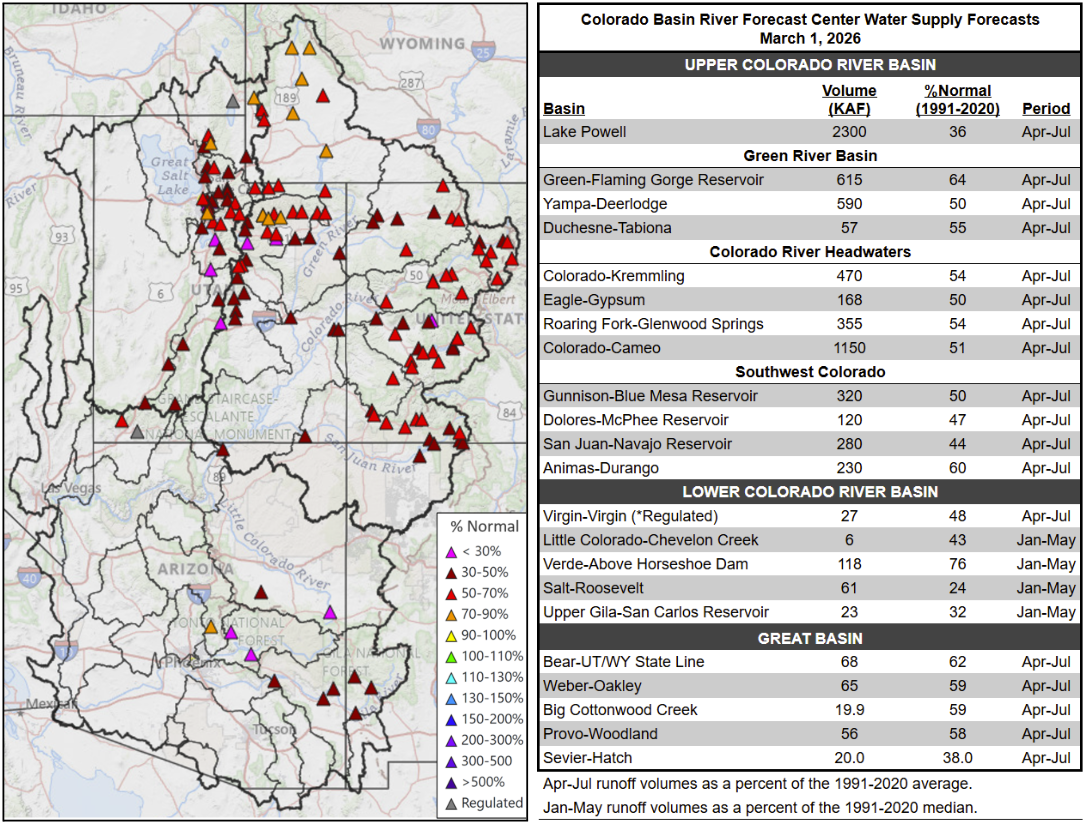
The Bureau bases its ‘averages’ on the recent 30-year average going by decades – so now the ‘long-term average’ is based on 1991-2020. Back as recently as 2019, it was based on the average from 1981-2010, which was more than a million acre-feet per year higher than the current 30-year average. God help us when we’re figuring in the decade of the 2020s into a 2001-2030 average – the new average would probably make this years runoff look better than it looks by the 1991-2020 average, but there’s certainly an element of delusion in that.
The ‘soft news’ about the Colorado River recently has been a declaration of ‘personhood’ for the river by the Colorado River Indian Tribes (CRIT). This is a lovely gesture by people who have been struggling for ‘personhood’ themselves for 150 years in the river’s region, and still are not quite at the table in negotiating over the river’s future, even though they have ‘used’ the river, often in fairly ‘civilized’ ways, for many hundreds if not thousands of years more than the white masters of the river.
But it seemed naive (or maybe just cynical) for the ‘lamestream media’ to ask if this declaration of personhood was going to ‘help save the river.’ We probably need to face the fact that, until we get serious about slowing down the warming of the planet, we can do nothing by way of nomenclatter to ‘help save the river’ – and even then, the best we could do would be to maintain the river where it is now, or at least not a whole lot worse – which is what’s going to happen if every year we continue to put more new greenhouse gases into the atmosphere than we did the year before. I do not see how considering the river a ‘person’ is going to change that much.
I think we should also consider that granting ‘personhood’ to another set of living ecosystems might be kind of anthropocentric. I can barely contemplate what goes into ‘riverhood,’ for example, but watching a stream one sees a system very much engaged in interaction with its whole neighborhood – giving water to the surrounding land when the land’s water table is low, and taking on water the land can’t hold when it is wet. ‘Riverhood,’ I infer, has aspects of sharing, giving and receiving, that might have things to teach us about improving ‘personhood,’ rather than operating on the assumption that all life on the planet would love to be reduced to ‘personhood’…. Just thinking out loud, sorry.

Our real question today is whether we can ‘save the river system’ – the structure for storage and distribution we have laid over the river – a question with which we need to actually spend some constructive time. And that kind of leads into the second part of my second ‘era’ in updating Fred Dellenbaugh’s 1903 Romance of the Colorado River: the ‘Era of Conquest.’ (First, remember, was the ‘Era of Exploration and Discovery.’)
World War II, where I left the story last post, is a natural break in the Era of Conquering the Colorado River. Prior to World War II, we saw the Bureau do its greatest work: overseeing the construction of Hoover Dam, Imperial Dam and the All-American Canal under the Boulder Canyon Project, as well as Parker Dam to back up water for the 250-mile Colorado River Aqueduct to the West Coast cities. It is hard not to call it a masterpiece of regional urban-industrial development. In our six or eight thousand-year history of humans trying to create ‘civilizations’ to constructively deal with exploding populations, the Boulder Canyon Act stands tall as a public work, fitting for a state struggling to become a mass-society democracy (possible?) rather than putting people to work on massive tombs for the self-proclaimed ‘God of the Sun’ or maybe ‘The Son of God.’
Advocates for private-sector industry will be quick to say it could not have been done without the private contractors, ‘the Six Companies’ and most notably Henry J. Kaiser. Critics of private-sector industry will be as quick to say that the private sector has not produced very many large-scale industrial organizers like Henry J – who demonstrated than you can do big work and also take good care of the people doing it. He did not rest on his laurels but capitalized on that regional system with his Fontana steel and aluminum plants and Liberty Shipyards up the West Coast.
The war effort cut off most domestic development – but the Bureau of Reclamation did complete two dams on the Colorado River during the war years. One was the Green Mountain Dam and Powerplant on the Blue River high in the river’s headwaters, part of the equally massive Colorado-Big Thompson Project. More about this in the next post.
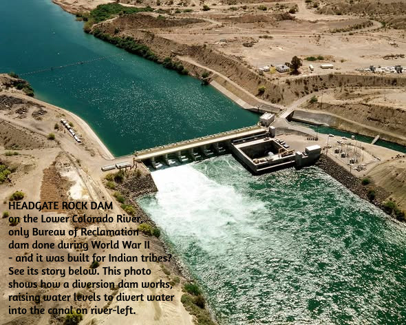
The other was a modest diversion dam below Parker Dam on the Lower Colorado: Headgate Rock Dam – for the Colorado River Indian Tribes! With all the tribes in the Colorado Basin feeling – righteously – left out of river development, one might think the Bureau would make a bit of a big deal about the fact that their first Colorado River project completed after the Boulder Canyon Project was a diversion dam for irrigating Indian agriculture. Yet I can find none of the usual historical and statistic evidence in the Bureau websites about the Headgate Rock Dam, like they have for all of the other Colorado River projects, each getting its own website. Possibly this is because the operation of the dam was turned over to the Bureau of Indian Affairs Office after construction was finished.
It is, however, an interesting story. The tribes along the river were farming like Nile Valley Egyptians, planting in the new layer of silt laid down annually by the snowmelt floods, crops that needed little further irrigation. That worked until the federal Indian agents started moving Hopi and Navajo bands onto their reservation in the 1860s – the reservations truly were ‘concentration camps,’ forcing the move to ‘civilized’ agriculture. This had moved the Indian agents to acquire some pumps round the turn of the century, to water land beyond the riparian floodplain. But when the gates on Hoover Dam were closed in the mid-1930s, that ended the annual snowmelt floods, also ending the traditional agricultural economy.
So the Bureau plotted out a gravity-flow diversion dam and canal in 1938, and began construction. But construction did not really accelerate until 1941, when in one of America’s most shamefully hysteric events 17,000 Japanese-Americans were ‘relocated’ to the Colorado River Indian Tribes (CRIT) reservation – undeniably a concentration camp at that point, if only for the concentration of people. But that added not just a lot of hungry mouths, but a proven workforce that joined the First People in working on the Headgate Rock Diversion Dam and the canal works to carry the water.
It would be both insensitive and naive to speak of a ‘happy ending,’ but as the interred Japanese did in many of the desert places they were sent to, their concentration camp became a very livable village system; some stayed on after the war, and today there is a memorial monument and periodic celebration commemorating the positive relationship that developed between two ‘unwanted peoples’ – the uprooted Japanese and the Indians who forcibly shared their homeland. A story that, for some reason, the Bureau is not interested in telling….
Meanwhile, however, the Bureau was not lying dormant. Immediately after the war’s end, the Bureau released what amounted to a smorgasbord of opportunities, under the title The Colorado River: A Natural Menace Becomes a National Resource. This proposed 134 possible projects for the development of the entire river basin for human uses – cautioning that there was not enough water in the river to build them all, thereby intruding the good old all-American element of interstate competition. Fifty-eight of those proposed projects were for the Lower Basin states, but the other 88 were for the Upper Basin states. If the pre-war Colorado River development had all been about the Compact’s Lower Basin states, the post-war development would begin with controlling the ‘natural menace’ in the Upper Basin states and putting the water to work.
The 1946 Bureau report divided the Upper Basin into three different divisions, based on the River’s three main tributaries above the canyons: there were 33 projects for the Green River Division out of Wyoming and Colorado but flowing mostly (but not entirely) through eastern Utah; 35 projects for the ‘Grand Division’ (the Upper Colorado-Gunnison Rivers, originating in Colorado but flowing into Utah (using the older name for the Upper Colorado); and 20 projects for the San Juan Division, most of whose tributary waters flowed out of Colorado’s San Juan Mountains but the river itself flowed mostly through northern New Mexico and southern Utah.
An obvious challenge lay in the absence of any coordination between those natural divisions of the Upper Basin and the geographically-irrelevant state boundaries. Every major tributary except for the Gunnison River crossed at least one state boundary. The Little Snake River in the Yampa River Basin is the extreme example, crossing the Colorado-Wyoming border seven times.
Nonetheless, the first task for the Upper Basin, before the Bureau could go to work, was to divide the use of the waters among the states in an Upper Colorado River Basin Compact. This task was made the more difficult because the state boundaries bundled the relatively water-rich Upper Colorado River Basin with other drier river basins – the Platte, Arkansas and Rio Grande rivers in Colorado, Wyoming and New Mexico; and the Great Basin in Utah. And water law – plus fervent belief in big-project technology – accommodated the notion of moving water from one river basin to another. The Grand Ditch from high on Colorado’s West Slope to the Poudre River on the East Slope was already being dug by the turn of the century. Unlike water for either agricultural or municipal uses within a basin, nothing flows back into the basin of origin from a transmountain diversion – a total depletion.
The task of dividing the use of the Upper Basin waters was also complicated by vague writing in the Colorado River Compact – Article III(d), stating that ‘the States of the Upper Division will note (sic) cause the flow of the river at Lee Ferry to be depleted below an aggregate of 75,000,000 acre feet for any period of ten consecutive years.’ Was this a caution to the Upper Basin states to make sure their uses did not start cutting into the Lower Basin’s shares? Or was it a mandate to those states to deliver that much water even if it meant cutting their own uses – essentially turning the Compact into a ‘senior water right’ to the Lower Basin?
This was not really foreseen as an issue in 1922, with a river that early 20th-century optimism assumed would run at around 18 million acre-feet (maf) forever. But after the drought of the 1930s and the middling flows of early 40s, plus the mid-war treaty with Mexico to deliver 1.5 maf across that border every year, it was evident to the Upper Basin state negotiators, who gathered in 1946 to work on an Upper Basin Compact, that the river might not always produce the 7.5 maf the Compact promised to them. Their preferred interpretation of the Compact’s Article III(d) would obviously be the ‘cautionary’ interpretation – don’t be the cause of the river flow declining. But they also knew that California and Arizona would interpret it as a ‘mandate’ – and since Congress would have to ratify their Compact, they chose to not ‘waken the bear,’ as California’s current governor would put it.
So rather than dividing the use of the Upper River’s hoped-for allotment of 7.5 maf in four set figures, like the Lower Basin has, they chose to divide it into percentages: 51.75% for Colorado (which provides around 70% of the river’s water), 23% for Utah, 13% for Wyoming, and 11.25% for New Mexico. They also chose to calculate their usage by their depletions of a stream’s flow rather than adding up consumptive uses, as the Lower Basin does. I will not pretend to know exactly how this works – except to note that a measure of depletions by users also includes evaporation and transpiration, while the Lower Basin’s measures allows such considerations to get lost in their calculations of usage. (The Bureau calculates Lower Basin evaporation and transpiration on a separate spreadsheet from recorded uses.)
Meanwhile, however -… Don’t you just love it when a writer intrudes ‘Meanwhile, however’ into an already complicated mess? This is my secondmeanwhile in this post, so it is probably time to give you a break, with only a teaser about the next step in this growing ganglia of complexity.
While the still somewhat beloved Bureau of Reclamation, creator of Hoover Dam and the New West, was just cranking up the mill for the development of the rest of the Colorado River Basin waters, the Upper Basin states had already been working out their separate peace over the transmountain diversion issue between the wet Colorado River basins of origin with low populations, and drier basins of destination with large populations across the mountains. This is a story that goes back to the 1930s, with the ‘New Deal’ federal government putting out large amounts of funding for public projects in all the states – but with the caveat that for any state to tap into that funding, the whole state had to want the project…. Stay tuned for the next thrilling episode in The West’s Romance with Conquest.