
Click the link to read the article on the NOAA website:
November 9, 2026
Key Takeaways:
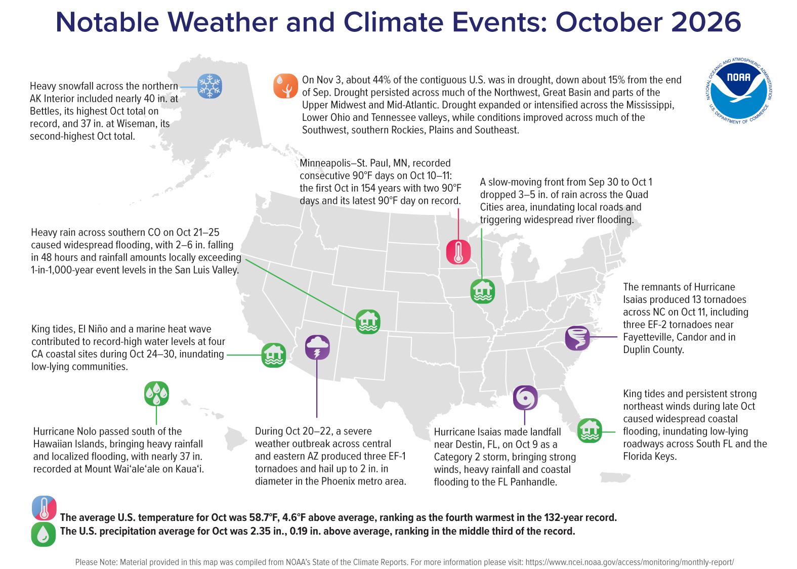
- Warm October: The contiguous U.S. (CONUS) recorded its fourth-warmest October in the 132-year record.
- Record nighttime warmth: For the fourth consecutive month (July–October 2026), the CONUS average nighttime minimum temperature set a new monthly record (1895–2026).
- Southwest tied its fourth-wettest October: The Southwest climate region averaged 2.68 inches of precipitation, 233% of its average October total.
- Hurricane Isaias makes landfall: Isaias became the latest first hurricane to form in the Atlantic basin during the satellite era (since 1966), making landfall near Destin, Florida, as a Category 2 hurricane and bringing strong winds and heavy rainfall across the Southeast.
- Drought improvement: According to the U.S. Drought Monitor, CONUS drought coverage fell from 59% on September 29 to 44% on November 3, its lowest level since January 2026.
Other Highlights:
Temperature
The average temperature for the CONUS in October was 58.7°F, 4.6°F above the 20th-century average, ranking as the fourth-warmest October in the 132-year record. October marked the 21st consecutive month (February 2025–October 2026) with CONUS temperatures above the 20th-century average.
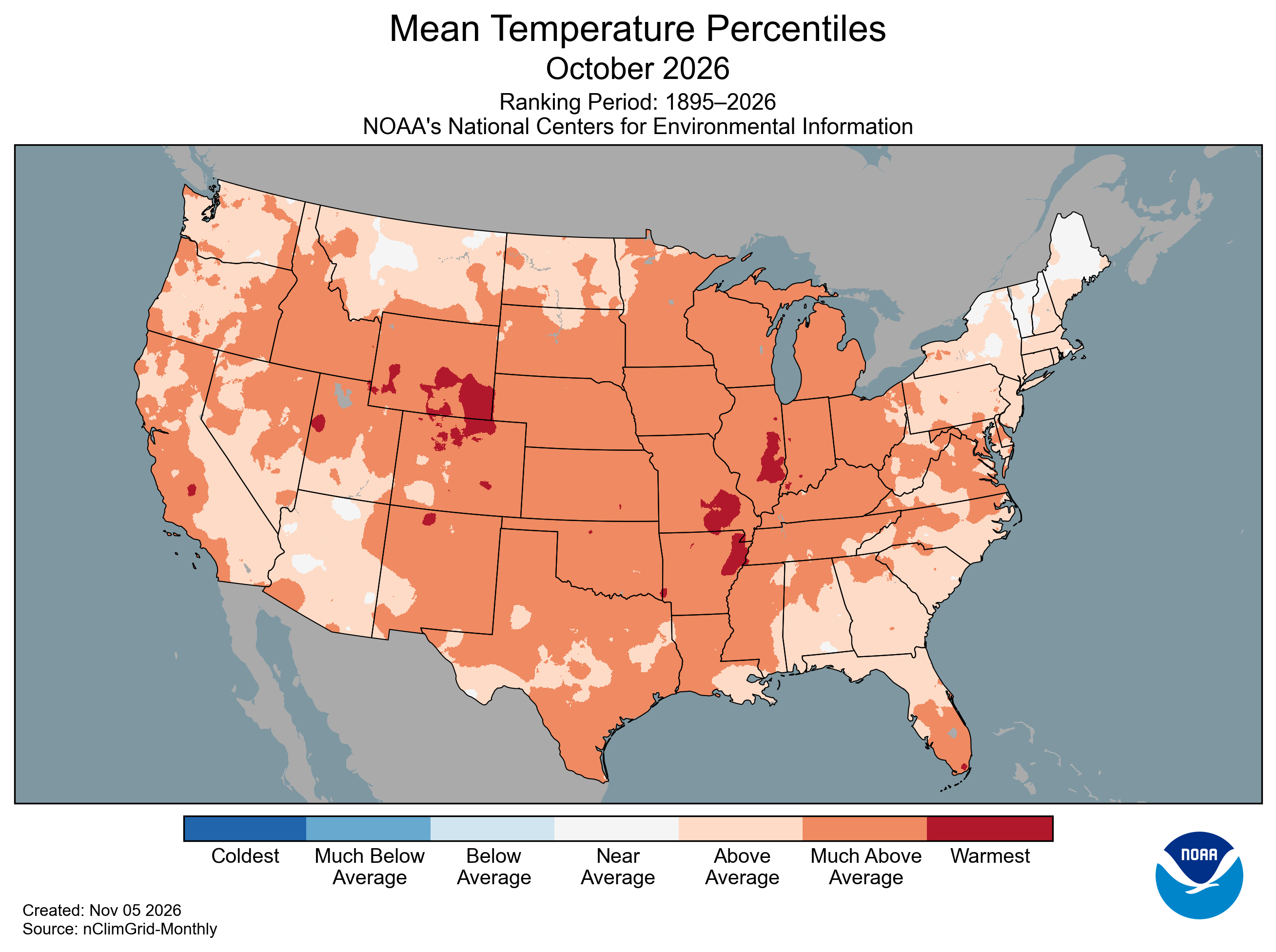
Above-average temperatures spanned the entire CONUS during October, with all 48 states recording average temperatures above their 20th-century baselines. Thirty states—extending from Oregon to North Carolina and Texas to Minnesota—experienced much-above-average October temperatures.
Nighttime minimum temperatures were especially notable, averaging 46.3°F, 4.9°F above the 20th-century average, and surpassing the previous October record, set in 1947, by 0.1°F. October marked the fourth consecutive month (July–October 2026) in which CONUS average nighttime minimum temperatures set a new monthly record.
Alaska’s average temperature was 30.4°F, 4.9°F above the 1925–2000 average, ranking in the warmest third of the 102-year record. While temperatures across southeastern Alaska and the Panhandle were near average, western portions of the state and the Aleutians experienced above- to much-above-average conditions.
Hawaiʻi’s average temperature was 69.0°F, 0.7°F above the 1991–2020 average, ranking in the warmest third of the 36-year record. While average daytime maximum temperatures were slightly below average, average nighttime minimum temperatures were 1.8°F above average, tying the record for the warmest October minimum temperature in the 36-year record.
Precipitation
Total precipitation averaged across the CONUS in October was 2.35 inches, 0.19 inch above the 20th-century average, ranking in the middle third of the 132-year record.

Much-above-average precipitation was widespread across southern California and much of the Southwest and Great Basin, extending into parts of the central and northern Rockies. Utah, Colorado, Arizona and Nevada each ranked among their 10 wettest Octobers on record. Portions of the central and southern Plains also experienced above-average precipitation, while rainfall associated with Hurricane Isaias contributed to above-average totals across parts of the Southeast. In contrast, northern California and the Pacific Northwest received below-average precipitation, along with portions of the northern Plains, Mississippi Valley, Midwest and Northeast.
Alaska’s average precipitation was 5.06 inches in October, 0.67 inch above the 1925–2000 average, ranking in the wettest third of the 102-year record. Above-average precipitation occurred across portions of the Northwest, southern mainland and southeast Interior, while the Aleutians, western Alaska Peninsula and Panhandle received below-average precipitation.
Hawaiʻi received 8.65 inches of precipitation in October, 3.53 inches above the 1991–2020 average, ranking as the third-wettest October in the 36-year record. Heavy rainfall associated with the southern passage of Hurricane Nolo contributed to the above-average totals. With statewide precipitation above average for the ninth consecutive month, year-to-date precipitation through October reached 95.31 inches, 46.23 inches above the 1991–2020 average, marking the wettest January–October on record.
Drought
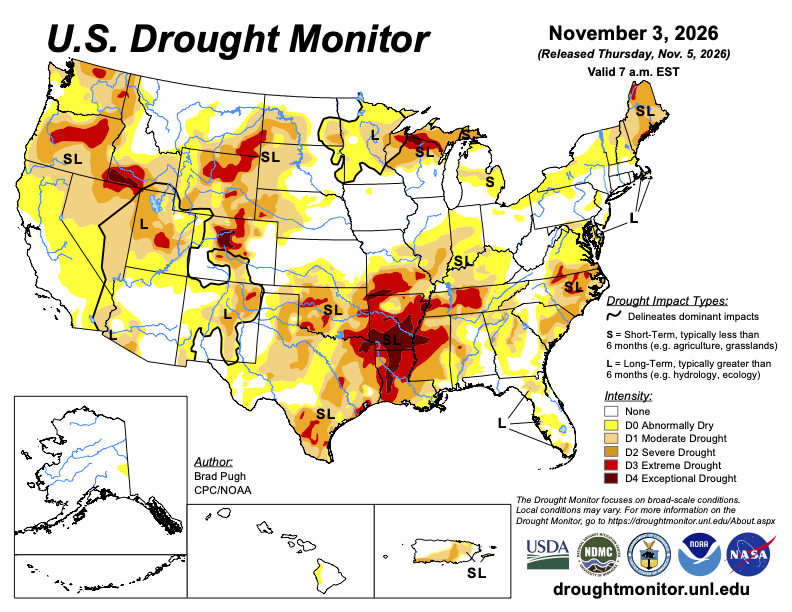
According to the November 3 U.S. Drought Monitor, about 44% of the CONUS was in drought, down about 15 percentage points from the end of September and the lowest CONUS drought coverage since January 27.
Drought persisted across much of the Pacific Northwest and Great Basin, parts of the central Rockies and northern Plains, the Upper Midwest, Mid-Atlantic, far Northeast and Puerto Rico. Drought expanded or increased in intensity across portions of the Lower and Middle Mississippi valleys and the Lower Ohio and Tennessee valleys. Drought conditions improved across much of the Southwest and southern Rockies, portions of the central and southern Plains and Southeast.
Monthly Outlook
Above-average temperatures are favored across much of the CONUS and Alaska during November, except for parts of the Southwest and southern Plains. The highest probabilities (exceeding 50%) are forecast across much of the northern tier. Above-average precipitation is favored across much of the West, Plains, South and Southeast, while below-average precipitation is favored across portions of the northern Rockies, Great Lakes and western Alaska. Visit the Climate Prediction Center’s Official 30-Day Forecasts for more details.
Drought is expected to persist across parts of the Northwest, northern Rockies and Plains, northern Great Lakes, the eastern Carolinas and far Northeast, while improvement is expected across parts of the Southwest and much of the southern Plains, Lower Mississippi and Tennessee valleys. Visit the U.S. Monthly Drought Outlook for more details.
Significant wildland fire potential for November is above normal across Puerto Rico and the U.S. Virgin Islands. Visit the National Interagency Fire Center’s One-Month Wildland Fire Outlook for more details.
For more detailed climate information, check out our comprehensive October 2026 U.S. Climate Report scheduled for release on November 13, 2026. For additional information on the statistics provided here, visit the Climate at a Glance and National Maps webpages.