
Click the link to read the article on the Colorado Climate Center website (Russ Schumacher):
November 11, 2026
This update is later than I had intended—last week was busy, with an excellent Lower Arkansas Valley water summit in Rocky Ford, and our fall Colorado Climate Center staff retreat. (Rest assured that you have an outstanding group of people committed to being the best a state climate office can be here in Colorado!)
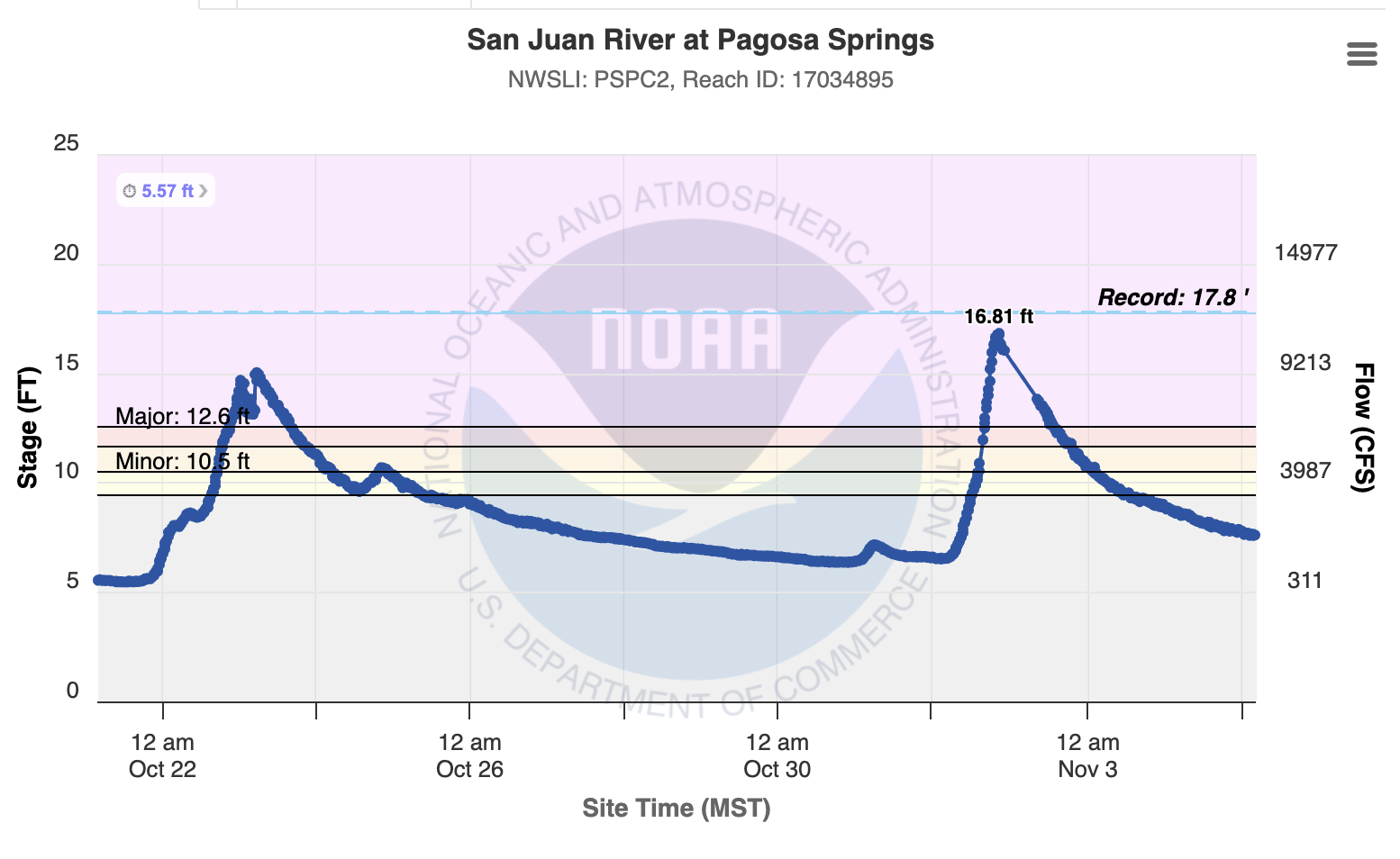
But us being busy at work is nothing compared to what the communities in southwest Colorado have gone through lately. Major flooding followed from a truly extreme rainstorm in late October. Then, around ten days later, another wave of tropical moisture moved into the southwestern United States and caused even worse flooding in many locations. At Pagosa Springs, the San Juan river crested even higher than in the flood the week before (or the flood last October). It’s possible that the flood crest was even higher than shown here owing to issues with the stream gage.
The damage was widespread, with homes lost and many crucial roadways washed out. The fate of the Pagosa Springs museum became one of the images that defined the flood.
The Durango area also saw extensive damage in the early-November flood; Mitch Tobin from the Water Desk has been sharing his photos documenting the situation in that area.

The details of the flooding have been extensively covered in local media like the Colorado Sunand the Durango Herald. Alan Gerard reviewed some of the challenges with the flood forecasts in this event, and I talked with Cory Reppenhagen of 9News about that topic as well. I expect that this event will motivate a lot of research going forward, because of the high impact of the floods and the unique forecasting challenges it highlighted.
Relentless rainfall since September
The early-November flood was (hopefully) the last in a string of heavy rainstorms that have affected southern Colorado going back to September. The first big storm was in mid-September, which caused some flooding around La Plata and Archuleta Counties, but was mostly viewed as welcome drought relief after many months of hot, dry conditions. Then, a couple weeks later, the remnants of Tropical Storm Polo moved across the southwest, with more heavy rainfall for southern Colorado. Then another storm in the middle of October. And then the extreme rainstorm and flood from October 22-25. And finally, the storm on November 1. The rainfall totals from the November 1 storm were not nearly as extreme as the late-October event, generally representing “only” a 10 to 25-year rainstorm for southwestern Colorado. But the precipitation totals since September have been staggering.
We just released our October monthly climate summary. It was the 4th warmest and 4th wettest October statewide — please read it for more of the weather and climate numbers from the last month. For much of southern Colorado, it was the wettest September-October period on record.
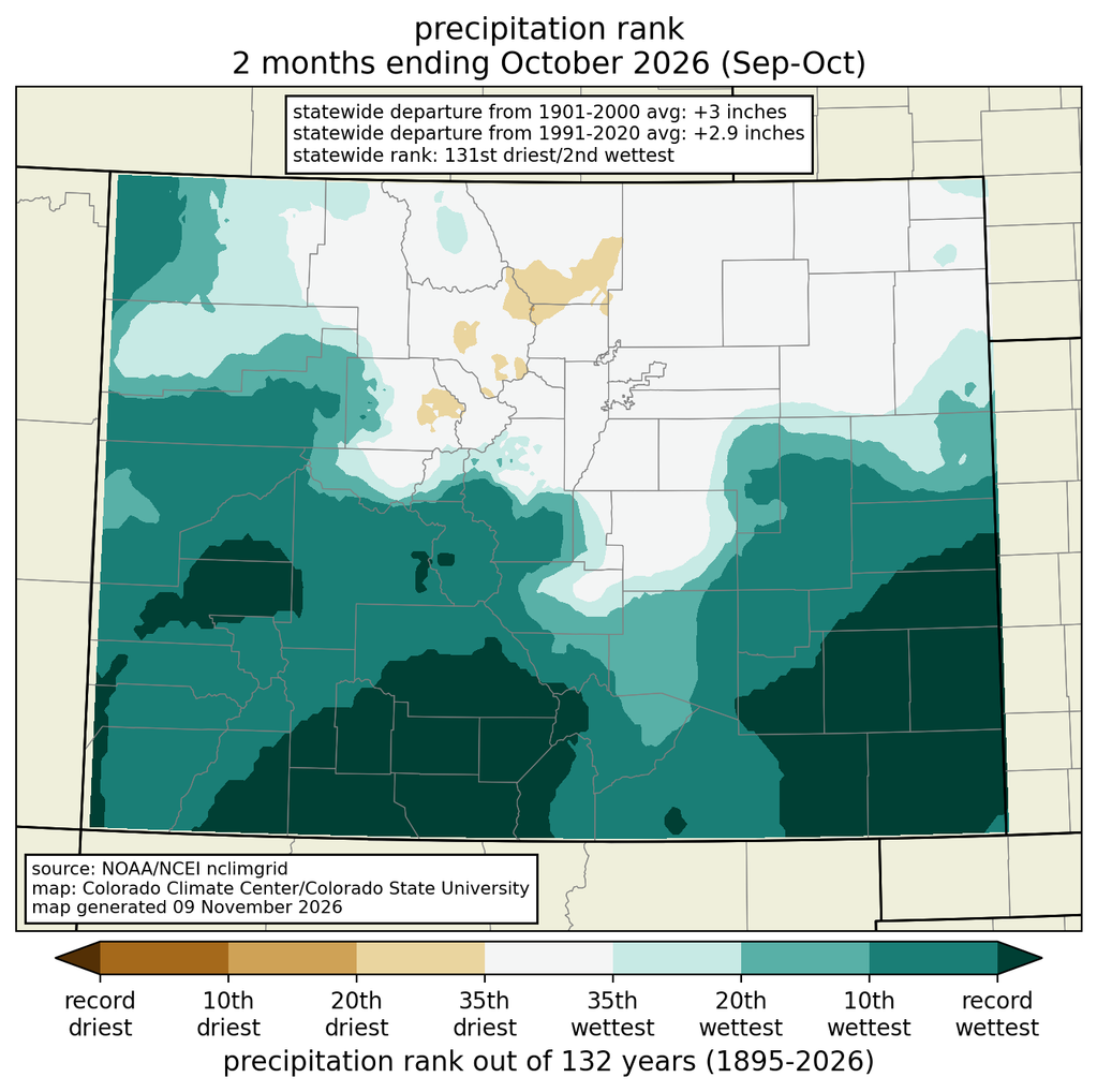
But these numbers don’t even include the early-November storm. Let’s add the rain from that storm for some truly outlandish numbers in southwestern Colorado. The map below shows the total precipitation from September 1 through the morning of November 5. The San Juan mountains received over 20 inches of precipitation in that time period, and a couple locations in the San Juans near Wolf Creek Pass recorded over 30 inches. Several stations around Pagosa Springs observed over 20 inches of precipitation in this just-over-two-month period. This is a huge amount of precipitation for this area, especially at lower elevations and when it’s not from big snowstorm cycles in the winter.

How huge are those amounts? In Archuleta County (home to Pagosa Springs), we already saw that it was the wettest September-October period on record. When we add in the early November storm, it will be the wettest September-October-November period on record. But it won’t just be a record for those three months: it has been wetter than any previous three-month period, period. The map below shows that for parts of Archuleta County since September 1, it’s been more than 6 inches wetter than any previous three-month period. In southern La Plata County and northern Rio Arriba County in New Mexico, it’s also been easily the wettest 3-month period on record (with a few weeks yet to go in November). A few areas around the Four Corners even surpassed their average precipitation for an entire year, in just over two months.

Drought relief
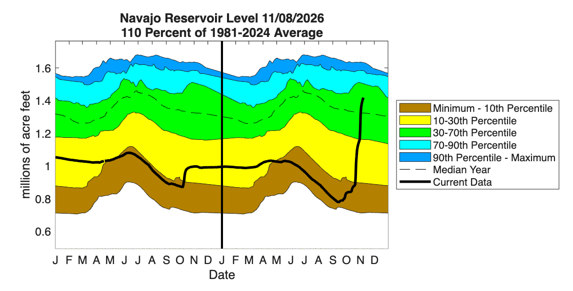
The upside is that there has been drought relief, at the cost of the major flooding. Almost all of southern Colorado is now drought-free on the US Drought Monitor, a remarkable turnaround after the winter, spring, and summer we went through. Storage in Navajo Reservoir, on the San Juan River in northern New Mexico, went from nearly record-low in early September to above-normal in early November. McPhee Reservoir on the Dolores River saw a similar turnaround, as did Lemon and Vallecito Reservoirs in southwest Colorado. The story on the huge reservoirs downstream on the Colorado River (Lakes Powell and Mead) is more complex, however. The good news is that Lake Powell has come up more than 20 feet in the last month; the bad news is that it’s still lower than it was at this time last year. Lake Mead has only seen a small increase in storage recently. So, despite some major drought relief in parts of the Colorado River basin (and again, at the great cost of destructive flooding), the impact on the broader water challenge with the Colorado River hasn’t been that significant.
Where to help
The team at Pagosa Weather, which once again has been doing a phenomenal job of both weather/flood updates and recruiting CoCoRaHS observers to collect data in the area, put together an excellent list of resources if you want to support the communities in La Plata and Archuleta Counties that have been hit so hard in the last two months.