The latest #ElNiƱo/Southern Oscillation (#ENSO) Diagnostic Discussion is hot off the presses from the #Climate Prediction Center

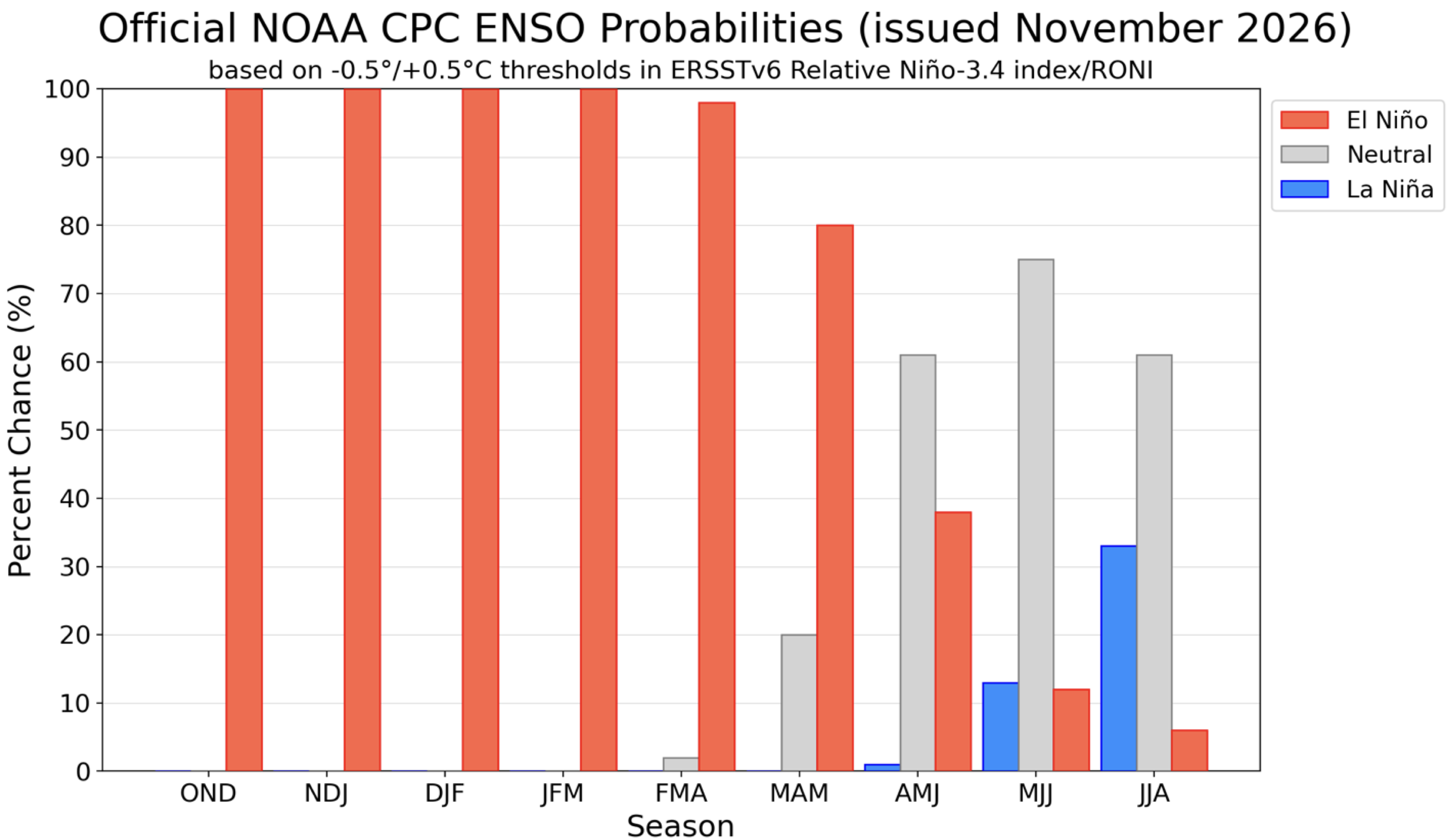
Figure 7. Official ENSO probabilities for the NiƱo-3.4 relative sea surface temperature index
(5°N-5°S, 170°W -120°W) minus tropical mean (20°N-20°S). The relative index is re-scaled to
match the variance of the traditional index. Figure updated 12 November 2026. Higher resolution
image/table: https://cpc.ncep.noaa.gov/products/analysis_monitoring/enso/roni/probabilities/

Click the link to read the discussion on the Climate Prediction Center website:

ENSO Alert System Status: El NiƱo Advisory

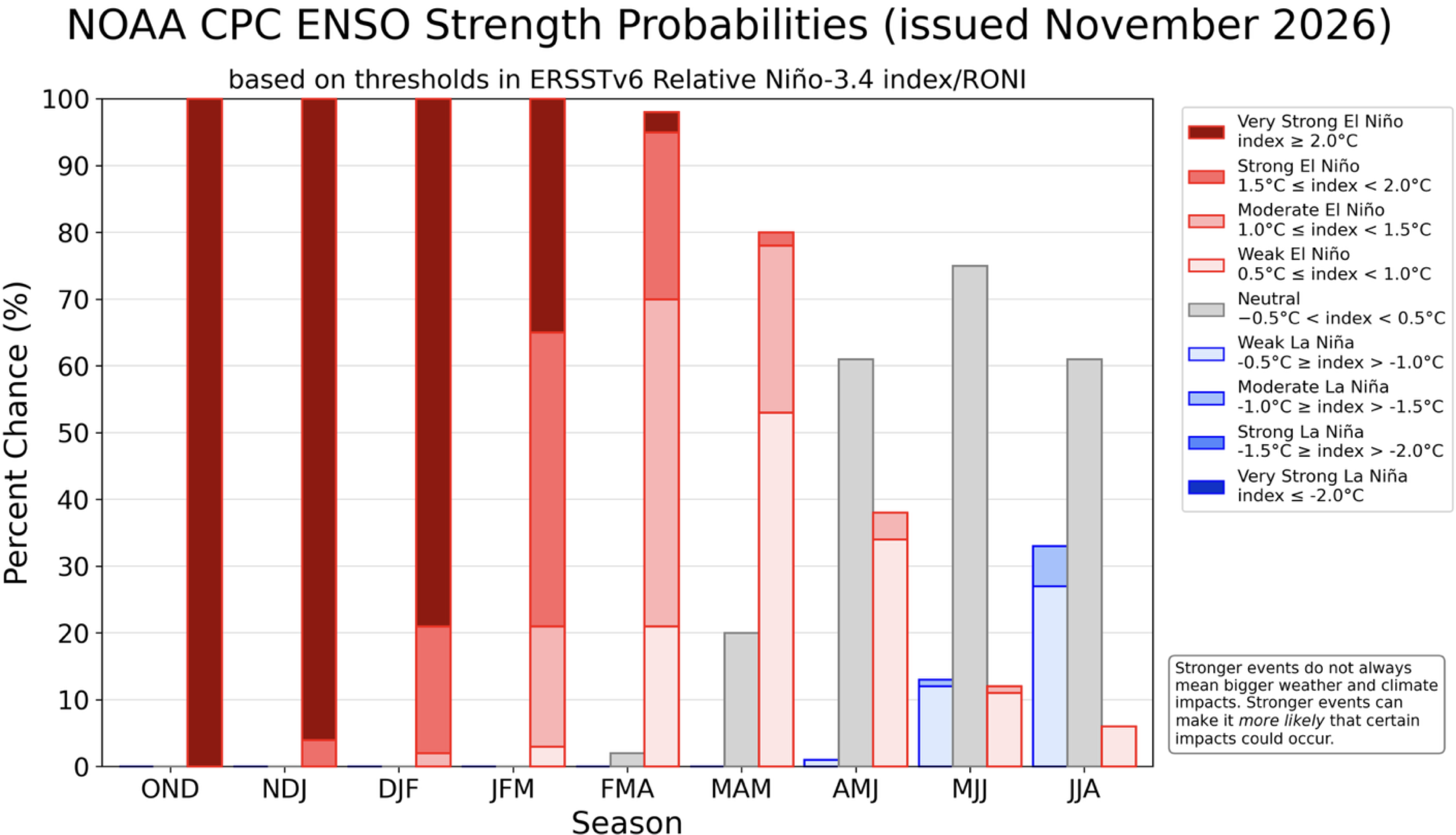
Synopsis: El NiƱo continues to strengthen, with a strong-to-very strong El NiƱo likely through January-March 2027 (remaining greater than a 79% chance).
Compared to last month, El NiƱo strengthened as sea surface temperature anomalies exceeded 4.0°C, extending farther westward across the eastern equatorial Pacific Ocean. The NiƱo indices increased, reaching +2.5°C in NiƱo-3.4, +3.6°C in NiƱo-3, and +4.4°C in NiƱo-1+2. The equatorial subsurface temperature index (average from 180°–100°W) remained significantly above average, associated with a deeper-than-average thermocline and anomalies exceeding +10.0°C at depth in the eastern Pacific Ocean. Low-level westerly and upper-level easterly wind anomalies extended from the western to the east-central equatorial Pacific. Convection and rainfall remained enhanced from the central to the eastern Pacific, while suppressed conditions persisted over Indonesia. The traditional and equatorial Southern Oscillation indices were consistently negative. Collectively, the coupled ocean-atmosphere system reflected the ongoing evolution of El NiƱo.

The CPC Official ENSO outlook, which synthesizes multiple models from North America and abroad, indicates El NiƱo will continue to strengthen before beginning to weaken in early 2027. Chances for a historic event exceeding previous El NiƱos dating back to 1950 (+2.5°C or more for a 3-month RONI value) are now ~60% for the October–December and November–January periods, remaining at better than even odds. Even with a very strong El NiƱo, the chances of experiencing impacts consistent with El NiƱo are higher, though not guaranteed (see CPC outlooks for probabilities of seasonal anomalies). In summary, El NiƱo continues to strengthen, with a strong-to-very strong El NiƱo likely through January–March 2027 (remaining greater than a 79% chance).

Figure 8. ENSO strength probabilities for the NiƱo-3.4 relative sea surface temperature index
(5°N-5°S, 170°W-120°W) minus tropical mean (20°N-20°S). The relative index is re-scaled to
match the variance of the traditional index. Figure updated 12 November 2026. Higher resolution
image/table: https://cpc.ncep.noaa.gov/products/analysis_monitoring/enso/roni/strengths/
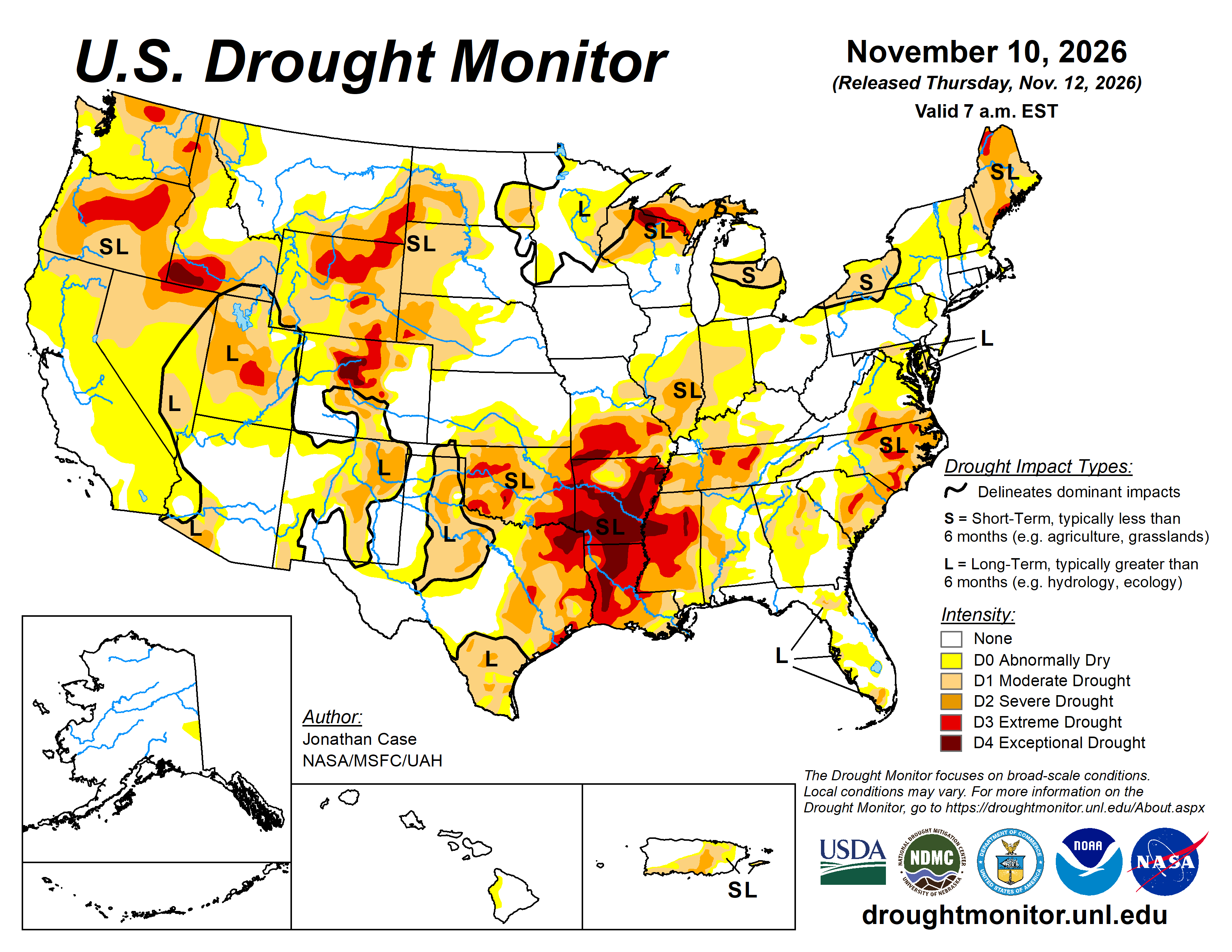
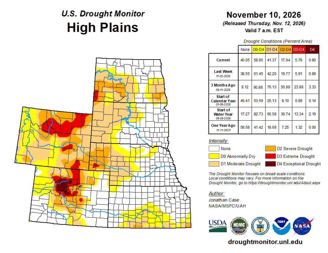
#Drought news November 12, 2026: Despite little rainfall in the Four Corners region of the S.W., additional improvements were made as a result of substantial rainfalls over the last several weeks, leading to tremendous flooding in some places and rapidly-filling reservoirs

Click on a thumbnail graphc to view a gallery of drought data from the US Drought Monitor website.

Click the link to go to the US Drought Monitor website. Here’s an excerpt:

This Week’s Drought Summary

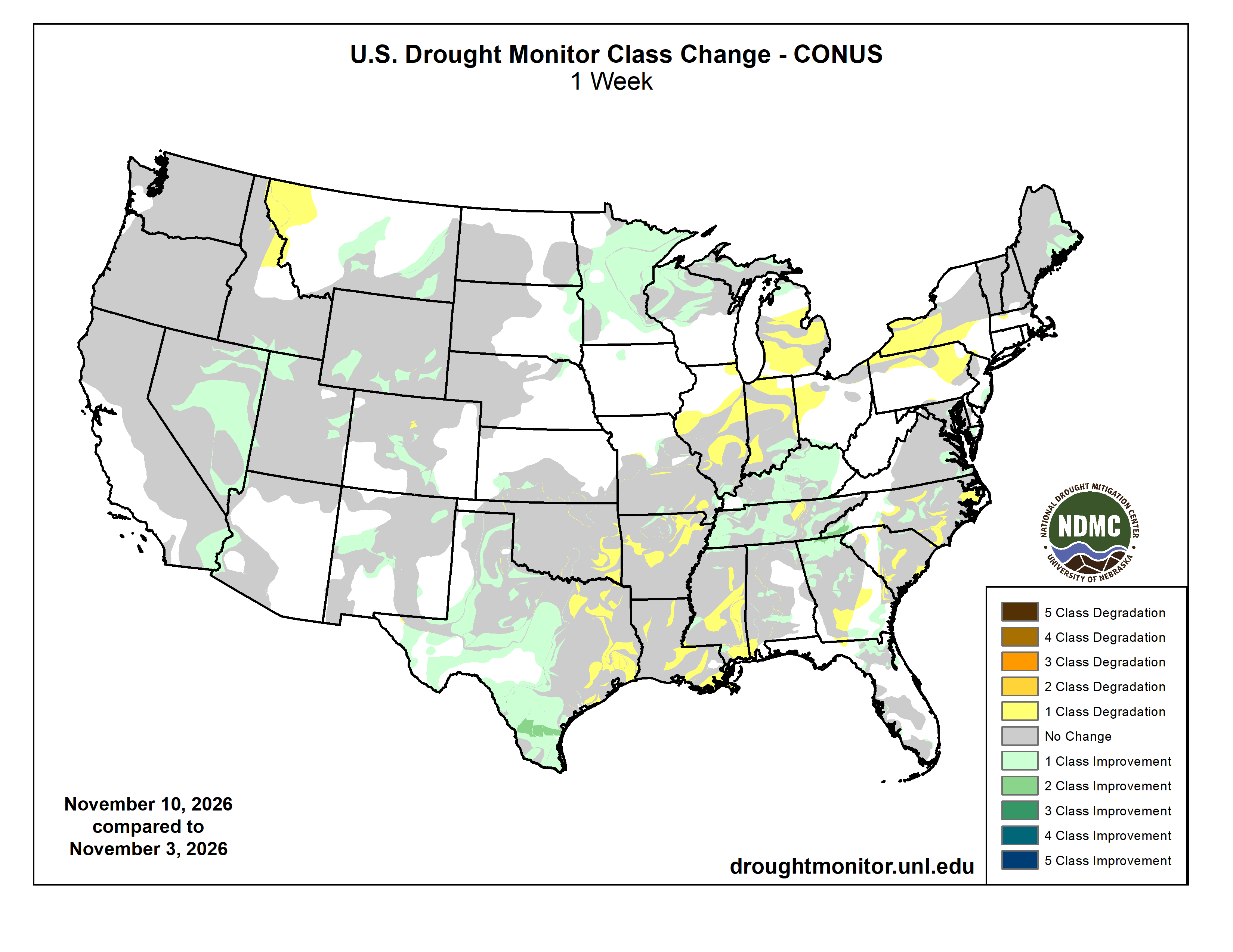
This week’s drought picture featured a mixed bag of conditions with worsening drought in the lower Mississippi valley and the lower Great Lakes region. Meanwhile, prolific rainfall continued in parts of the Southwest, South, and Southeast, leading to significant drought improvement across southern and western Texas and parts of the Southern Appalachian region. Additional drought improvement was found over the western Great Lakes in Minnesota and Wisconsin and parts of the Upper Peninsula of Michigan. Despite little rainfall in the Four Corners region of the Southwest, additional improvements were made as a result of substantial rainfalls over the last several weeks, leading to tremendous flooding in some places and rapidly-filling reservoirs…

High Plains

The High Plains States were the least active in terms of drought category changes this past week as little precipitation fell. With evaporation rates reduced this time of year, any worsening drought moves at a much slower pace. Only spotty drought improvements from rainfall occurred in Eastern South Dakota into Northeastern Nebraska, and Southwestern Kansas…

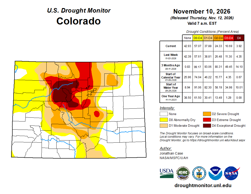
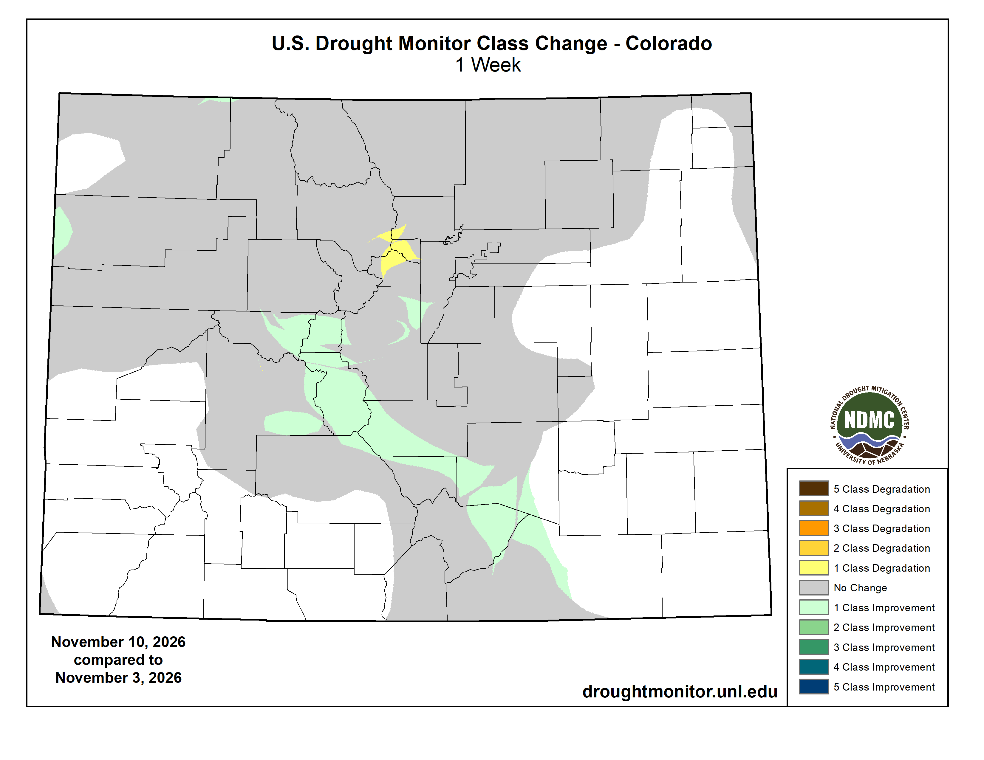
Colorado Drought Monitor one week change map ending November 10, 2026.

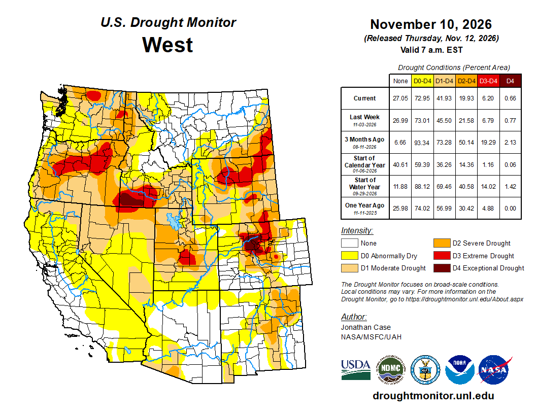
West

Despite an overall lack of substantial rainfall in the West this past week, continued drought improvements were made across many states from Southeast Montana southward to New Mexico and westward to Southern California and Nevada. Near-record soil wetness has resulted from the recent weeks of tremendous El NiƱo-influenced rainfall. It hasn’t been all good news in the West, as some drought degradation was introduced in northern Idaho and northwestern Montana this past week.

Many reservoirs have been filling up at an exceptionally rapid pace in the Desert Southwest, making up for months of declining levels over just the last few weeks. The Navajo reservoir in Northwestern New Mexico has added over 600,000 acre-feet of water since mid-September from recent rain and flooding events, and now sits at 110% of average storage for this time of year. Lake Powell behind the Glen Canyon dam has also benefited tremendously with the addition of almost 1.4 million acre-feet of water since mid-September. However, Lake Powell is still only at 42% of average storage for this time of year…

South

The drought pattern continued to be quite polarized across the Southern States, with exceptional drought worsening across Arkansas, Louisiana, Mississippi, Southeastern Oklahoma, and Eastern Texas. According to the National Centers for Environmental Information, 20 to 30 inches of rainfall is required over the span of 3 months to end the exceptional drought in these states. In stark contrast, substantial rains fell in Southern and Western Texas resulting in one and two categorical reductions in drought intensity, especially over South Texas where up to 9 inches of rain fell. Significant drought relief occurred across much of Western and Central Tennessee where several inches of rain fell in some places this past week helping to reduce the extreme drought to some extent…

Looking Ahead

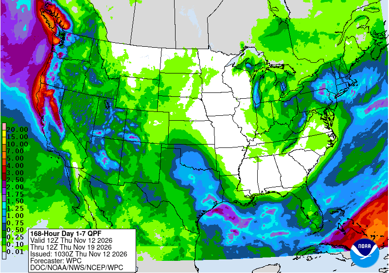
Over the next week, a potential Nor’easter could bring substantial rainfall to interior portions of Pennsylvania, New York, and Southern New England. A series of potent weather systems should impact the West Coast from Central California up to Washington, with up to 5 inches or more of precipitation being predicted by the NOAA Weather Prediction Center through next Tuesday. Another axis of substantial rainfall is predicted from Eastern Texas into Oklahoma and Southern Kansas. The Northern Plains and the Southeast are predicted to stay mostly dry. The NOAA Climate Prediction Center depicts well above normal temperatures across much of the Plains States, with below normal temperatures in the Southeast. Precipitation is projected to be above average in the Southwestern U.S. and below average over the eastern half of the country.

US Drought Monitor one week change map ending November 10, 2026.