Far from farms and cities, dry climates are boosting river nitrate pollution — Li Li (李黎) (TheConversation.com)

Typically, when people hear about nitrates, it involves runoff from farm fields, sewage systems and cities that can fuel harmful algae blooms and raise the risk of a serious illness in infants known as “blue baby syndrome.”

But a river can also run through a sparsely populated landscape with little farming and still contain surprisingly high levels of this form of nitrogen that can harm aquatic life, drinking water and human health.

In a new study, my colleague and I found a reason why that happens: Dry climate conditions are associated with high river nitrate concentrations, even in places with little farming or urban development.

We found nitrate hot spots in some unexpected places, including the Rocky Mountains of the western United States and northern Africa’s Sahara Desert. Where water is scarce, we found that nitrates – which can naturally leach into surface water and groundwater from the soil as microbes break down organic material – were able to accumulate and become concentrated rather than being diluted or flushed away.

That raises health concerns for regions where nitrates in rivers and well water might not be given much thought. It also raises questions about how nitrate-related health risks will increase as global temperatures rise.

A maps shows high nitrate levels in the U.S., Europe and India, as well as across dry parts of Africa.
A global map of predicted river nitrate concentrations reveals elevated concentrations in arid, remote regions. Li Li, et al., 2026

To see how widespread this pattern is, we combined global measurements from more than 7,000 monitoring sites and additionally extracted information about climate, soils, land use and other landscape features. We then trained machine learning models to estimate long-term average nitrate concentrations across nearly 2.9 million river segments worldwide.

The resulting map suggests that nitrates deserve attention well beyond the urban and agricultural regions where they are usually monitored.

Why it matters

High nitrate exposure in water and food is particularly dangerous for infants because it can interfere with the blood’s ability to carry oxygen. Blue baby syndrome, or methemoglobinemia, can result in serious illnesses and be caused by nitrate poisoning.

The U.S. drinking water standard of 10 milligrams of nitrate-nitrogen per liter was established primarily to guard against this acute risk.

We estimate that about 37,000 people worldwide live in areas where rivers exceed the 10 mg/L drinking water standard, predominantly in the U.S. Corn Belt.

That doesn’t mean 37,000 people are drinking water at those concentrations, since river water in many regions is treated before it is supplied for drinking. But it’s a concerning level they should be aware of, particularly those using well water.

3 women in a farmhouse kitchen
Rural well water can carry more nitrates than residents realize. Curly photo/Moment via Getty Images

Research has also raised concerns about possible effects of long-term exposure to nitrate at lower concentrations, including certain cancers and adverse birth outcomes, such as babies born preterm or with a low birth weight, although those risks are still being studied.

We estimate that about 480 million people worldwide live in areas where nearby rivers have elevated long-term average nitrate concentrations, above 2.5 milligrams per liter.

Many of the rivers our models identified as having elevated nitrate levels are small headwater streams. Many headwater streams cease to flow for some periods of time every year, and nitrates can accumulate to high concentrations under dry or low-flow conditions. These small streams make up most of the global river networks, have long been overlooked and feed larger rivers that supply drinking water to large populations and help shape the quality of water downstream.

Too much nitrate in rivers and lakes can also fuel algal growth and disrupt aquatic ecosystems.

What we still don’t know

A global map of nitrate concentrations in river water cannot show what comes out of someone’s tap. Their water may be mixed with other sources or treated before they drink it. Nitrate concentrations can also rise and fall over time, while our map shows long-term averages.

To understand a person’s actual exposure will require connecting river measurements with drinking water sources, treatment practices and tests of water delivered to households.

Many rivers with nitrate concentrations above 2.5 milligrams per liter flow through sparsely populated regions where access to treated drinking water may be limited. Even where treatment facilities exist, conventional methods remove little nitrate. Removing it requires specialized technologies that can be costly to operate.

What comes next

Our study shows why more drylands and small headwater streams need to be monitored for nitrate. It also raises a question for a warming world: If a region becomes drier, how much will nitrate concentrations rise even if people do not add more nitrogen to the landscape?

Answering that will require measurements through wet and dry periods, paired with studies of how water moves through soils, groundwater and rivers. For now, the message is clear: Protecting water quality requires paying attention to the climate as well as to the human activities that put nitrogen into the environment.

Li Li (李黎), Professor of Civil and Environmental Engineering, Penn State

This article is republished from The Conversation under a Creative Commons license. Read the original article.
Pipeline to share water between #Parker, #CastleRock and northeastern #Colorado farms OK’d in water court — Jerd Smith (Fresh Water News) #SouthPlatteRiver

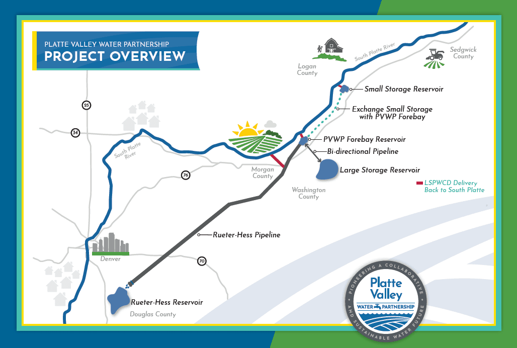
Platte Valley Water Partnership project overview. Credit: Parker Water

Click the link to read the article on the Water Education Colorado website (Jerd Smith):

October 29, 2026

A $1.1 billion reservoir and pipeline project designed to provide water to Parker, Castle Rock and a key farm region in northeastern Colorado has cleared a major hurdle in water court.

The Platte Valley Water Partnership, formally launched in 2021, includes the Lower South Platte Water Conservancy District in Sterling, as well as the two cities.

Water projects in Colorado must undergo review by special water courts, a process that allows other water right holders who might be affected to examine the deal. The court’s approval earlier this month opens the door for permitting and construction work to begin, said Ron Redd, general manager of the Parker Water and Sanitation District.

The partnership plans to build a 125-mile pipeline, a new plains reservoir and diversion structures that will serve farms and small towns along the Lower South Platte River to the southern Denver metro area. The cost of the project will be shared between water users, with Parker picking up 52% of the tab, the Lower South Platte district picking up 27% and Castle Rock paying 20%, Redd said.

Advocates of the pipeline and reservoir say it represents a new way to divide dwindling water supplies between cities and rural ag-dependent economies without drying up farmland, a practice known as “buy and dry.”

“It’s not buy and dry. It’s a different method,” said Gene Manuello, a long-time rancher and feed lot operator who also sits on the board of the Lower South Platte Water Conservancy District. “The need for water up here isn’t nearly as big as the need to protect against buy and dry.”

The deal includes strict rules that prohibit any water that has been obtained by taking it off farm fields from being stored or delivered through the project.

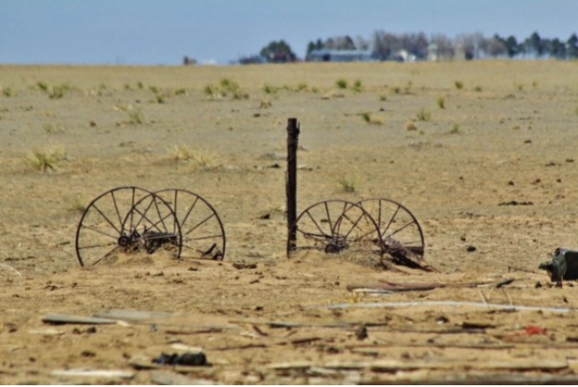
Colorado has lost more than 30% of its irrigated ag lands in the past 30 years, according to the National Agricultural Statistics Service. The loss has occurred largely because of drought and ongoing efforts by fast-growing Front Range cities to buy farms on the Eastern Plains, and shift water that once irrigated crops to city use.

Photo of Crowley County by Jennifer Goodland

The Lower Arkansas River Valley has been particularly hard-hit, with cities such as Aurora and Colorado Springs buying thousands of acres of land, and transferring the water north to their communities via the Arkansas River and pipeline projects built decades ago. Both cities have worked closely with some growers to mitigate the impact of the loss of irrigated lands, but concerns remain high, especially as drought continues to shrink available water supplies.

How the deal intends to help the farm economy

The Platte Valley Partnership is intended to help the farm economy by making more water, not less, available to growers, Redd said.

“It feels like a new way to do business,” he said. “We didn’t buy anything and dry it up, and we won’t allow anyone to dry up land and put the water in our pipeline.”

With the water court’s approval, the Platte Valley Partnership now has a new 2019 water right. This means it won’t be able to divert in most years, but it will be able to divert during big rain storms and floods, such as those that occurred in 2013 and 2023, Redd said. The new right is estimated to produce nearly 22,000 acre-feet of water for farm communities and the same amount for urban areas. One acre-foot roughly equals nearly 326,000 gallons, enough to serve at least two to three households in a year.

With the water right approved, Redd said permitting work and construction can begin on the first phase, a diversion structure and pipeline that will deliver water to the farmers in the next five to seven years.

“We thought it would be nice to get the farming community up and running,” Redd said.

Delivering water to the cities will take longer, with completion slated for 2040, depending on permitting and construction timelines.

One of the challenges of the partnership is how to keep water affordable for farmers, who typically pay much less for water than cities.

Joe Frank is manager of the Lower South Platte Water Conservancy District. He said work is beginning now on how to structure costs.

“We don’t know what it looks like yet,” Frank said. “But we’re looking at sharing costs based on the economic benefits of the project. Our users might get 50% of the water, but they won’t pay 50% of the costs. We’re looking at grant funding to help with our side of this. And we might go to a vote of the people to secure bonding authority.

“It has to be affordable,” Frank said.

Phase one of the project comes as Colorado and Nebraska pursue a U.S. Supreme Court case over whether Colorado is already overusing its share of the South Platte River, something that Colorado denies.

Nebraska has said it wants to build the Perkins Canal in northeastern Colorado to help it capture water it says it is owed under the 1923 South Platte River Compact.

But Platte Valley Partners say their project is being built within the legal confines of that compact and state water law.

“This is not Nebraska’s water,” Redd said.

More by Jerd Smith

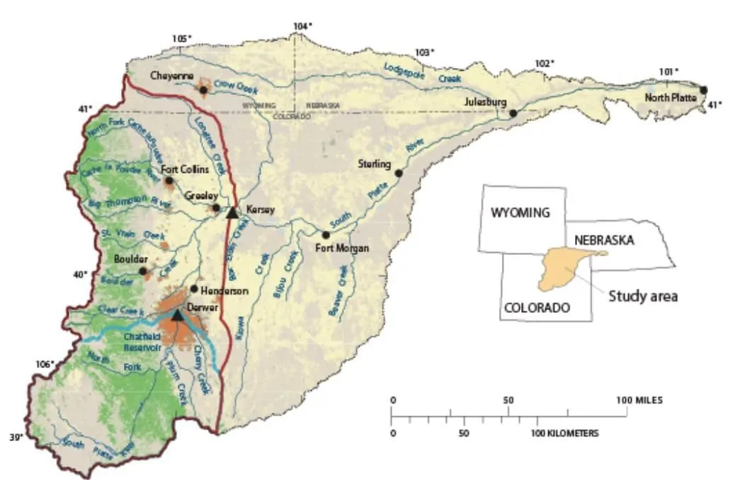
The South Platte River originates in South Park and then wanders northeast, entering Nebraska just a few miles west of Colorado’s northeast corner. The red line here distinguishes the upper South Platte Basin in Colorado from the lower basin. The compact between Colorado and Nebraska speaks only to the lower basin. Image: U.S. Geologic Survey.
Map of the Arkansas River drainage basin. Created using USGS National Map and NASA SRTM data. By Shannon1 – Own work, CC BY-SA 4.0, https://commons.wikimedia.org/w/index.php?curid=79039596