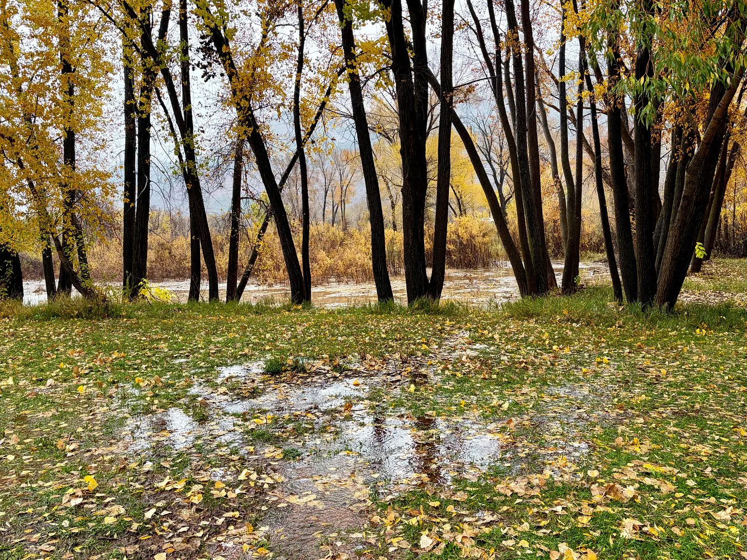
A slough in the west Animas Valley north of Durango. The wetlands pictured here have been mostly drylands in recent years, but filled up and saturated surrounding ground during the previous high water in late October. Now it’s rising again as torrential rains pound the region. Jonathan P. Thompson photo.
It’s Sunday afternoon, the first day of November, and if tomorrow is the Day of the Dead, today is the Day of the Deluge here where I sit, a couple miles north of Durango. A hard rain has fallen relentlessly for the past 15 hours or so, only occasionally easing up for a few minutes at a time. An hour ago, the La Plata County Sheriff sent out an alert closing all county roads due to flooding conditions. While the segment of county road I’m on remains passable, numerous other roads have shut down themselves as debris flows bring mud, silt, and high water onto the roadways.
In need of provisions, and with a journalistic desire to see what the hell was happening out there, a friend and I ventured out to find waterfalls spilling off of Animas Mountain onto the highway into town, bringing rocks and silt with them. The liquor store, abiding by the shelter-in-place order, was just closing up for the day as we arrived.
Reports poured in about flooding around town: Highway 160 just east of town had turned to a river after Lightner Creek apparently jumped its banks; Junction Creek also was flooding, affecting some homes and forcing evacuations. To the south, San Juan County, New Mexico’s Office of Emergency Management urged all residents within a half mile of the San Juan, Animas, and La Plata rivers to head to higher ground. As the text alerts reached phones, and the serious of the situation became apparent, the roads emptied out.
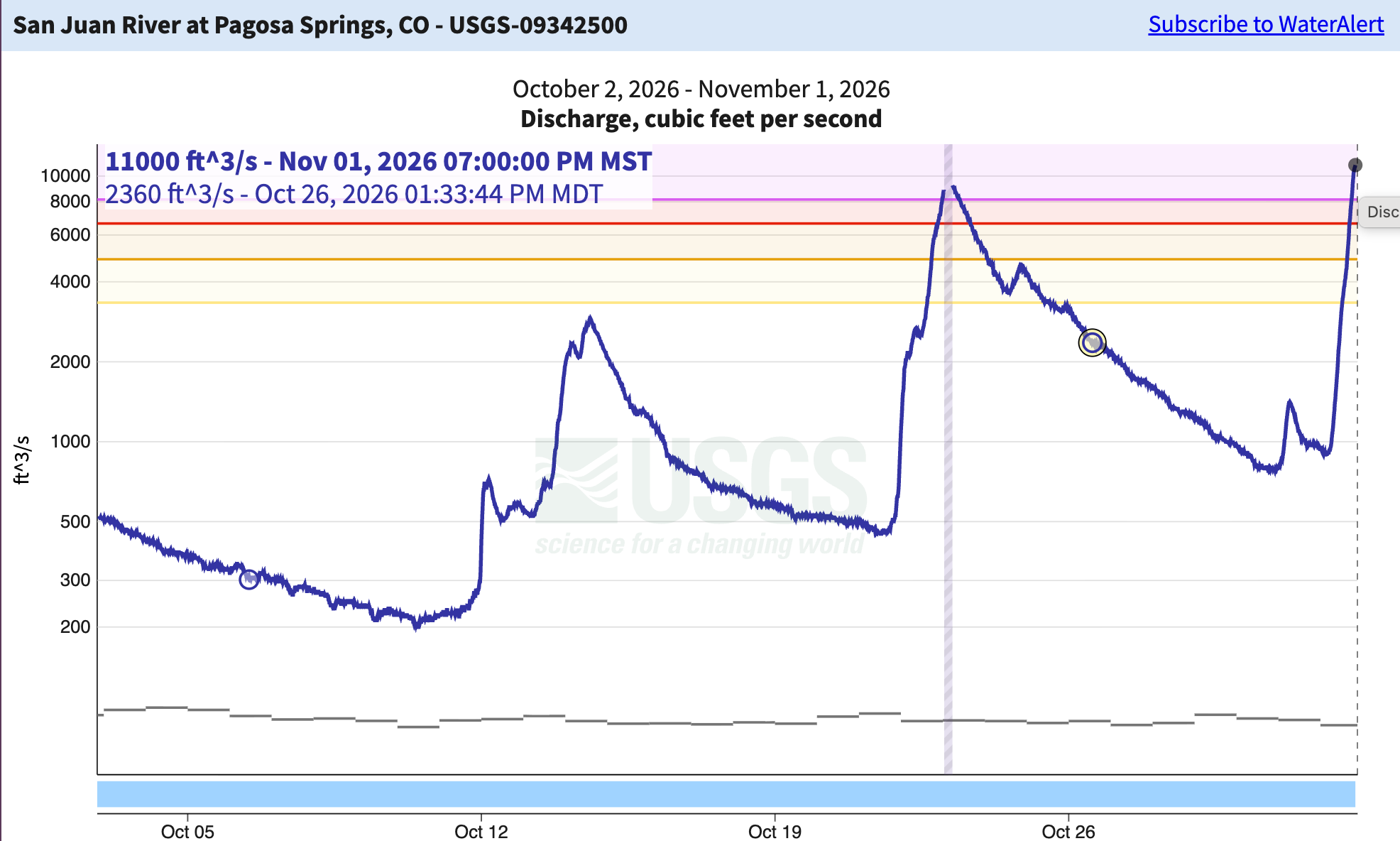
So far, the flooding is mostly limited to arroyos and smaller waterways, but the major rivers continue to rise. Parts of Pagosa Springs and surrounding areas along the San Juan River are under a mandatory evacuation order as I write this, and the river is forecast to crest around 19.71 feet, or about four feet higher than the Oct. 23 peak (9,100 cubic feet per second). If it reaches that point, it will not only cause catastrophic damage, but would also be larger than the 1911 flood, making it the largest on record, by far.
Even if the river levels don’t meet or exceed those of October 1911, this autumn’s deluges are still historic. Autumn storms and floods are not uncommon in this area. But to have a succession of storms this big, dumping this much moisture, and bringing multiple rivers and streams to record or near-record levels over just a few weeks, is very unusual and possibly unprecedented, at least over the last 130 years or so. It’s also extraordinarily challenging for those who live in the path of these rivers, arroyos, and streams — people who are only beginning to muck out the sewage-tainted silt from the last flood a week ago.
Also somewhat freakish is the timing: Flooding on Nov. 1 is odd because typically the moisture would be falling as snow by this time of year, which would keep the moisture on the ground rather than in the streams. Yet as of Sunday afternoon, it was still coming down as rain and Schneeregen up to about 11,000 feet in elevation, melting existing snow and leading to big streamflows in high country creeks and rivers. The snow-line is expected to drop considerably later tonight, snarling travel while also creating a nice base for the snowpack. If it comes soon enough, it may even keep some of that moisture out of the streams — at least until next spring, when it’s needed.
In the meantime, we sit and wait and watch nervously to see what the rivers will do.
Some notable streamflow data from around the region, as of Nov. 1 at about 5 p.m. (keeping in mind this is all provisional, real-time data):
McElmo Creek near the Colorado-Utah state line hit 1,610 cfs at 2:45 pm on Nov. 1, which is about 30 cfs higher than the Oct. 22 high mark.
The Piedra River near Arboles was at 16,800 cfs at 8 p.m. on Nov. 1, just 200 cfs short of its peak during last week’s floods (when the gage was knocked out of commission).
The San Juan River at Pagosa Springs was at 11,000 cfs at 7 p.m. — 2,000 cfs higher than last week’s flood — and still rising. The gage height is on track to exceed 1911’s, though it’s not yet clear that the streamflow will beat 1911’s 25,000 cfs. Either way, it will be devastating.
The Animas River at the gage in Durango was at 4,790 cfs and still rising at 4:30 p.m. At the same time, the gage just downstream (below the confluence with Lightner Creek) 7,010 cfs, indicating that Lightner Creek was somewhere around 1,200 cfs (there’s no gage on that stream).
That’s nothing compared to what was going on further south and west …
Oak Creek near Cornville, Arizona, jumped from 165 cfs to over 27,000 cfs in a matter of hours on Nov. 1.
The Salt River just upstream from Roosevelt Reservoir was at 107,000 cfs and rising at 5 p.m. on Nov. 1. That’s an insanely huge amount of water. It’s also the third highest flow on record in over a century.
The Agua Fria River near Rock Springs, Arizona, was virtually dry a few weeks ago. Today, it reached 22,900 cfs.
The Verde River below Tangle Creek in central Arizona was at 89,000 cfs at 6:14 p.m. on Nov. 1.
That’s it for now. I’ll be trying to put this all into context if and when the waters subside …
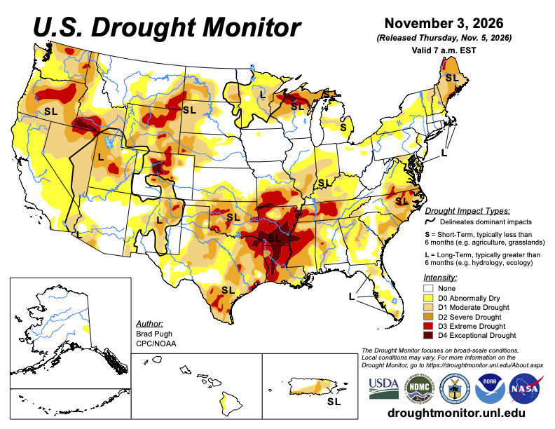
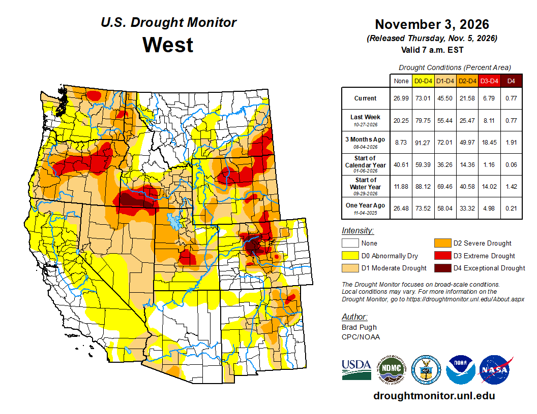
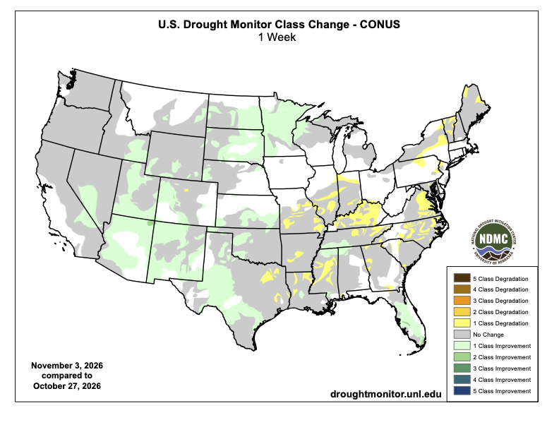
The very wet fall continued across the southwest quarter of the contiguous U.S. to end October. Based on the additional heavy precipitation (more than 1 inch) from October 27-November 2 and a positive shift in the long-term metrics since September, a broad 1-category improvement was made to the Southwest and Great Basin. Although short-term drought has ended, lingering long-term drought remains designated for parts of these areas. The remnants of Hurricane Vance from the East Pacific brought drought-improving precipitation to western and central Texas. At the start of November, heavy precipitation prompted improvements to the Great Plains and Upper Mississippi Valley. Drought coverage continued its late summer and fall decline across Florida. Drought expanded and intensified for parts of the Lower to Middle Mississippi Valley, Ohio Valley, Mid-Atlantic, and New England. Alaska and Hawaii remain drought-free, while drought continues to improve across Puerto Rico…
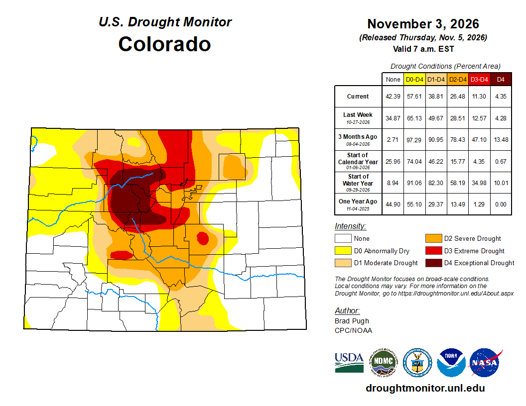
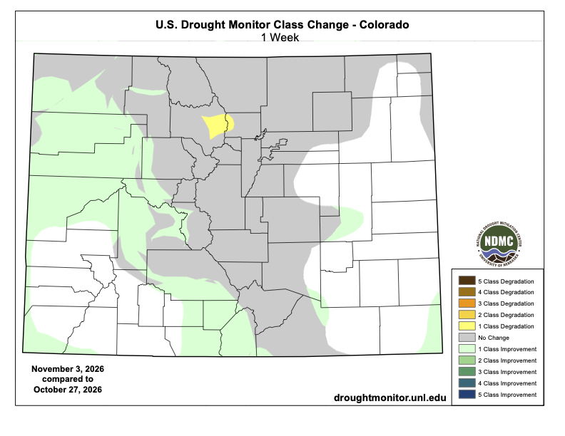
Widespread precipitation (0.5 to 2 inches, locally more) resulted in 1-category improvements to the western third Colorado along with parts of the Northern to Central Great Plains. Recent precipitation and the “convergence of evidence” supported discontinuing the D3 in most of the Nebraska Panhandle…
Colorado Drought Monitor one week change map ending November 3, 2026.
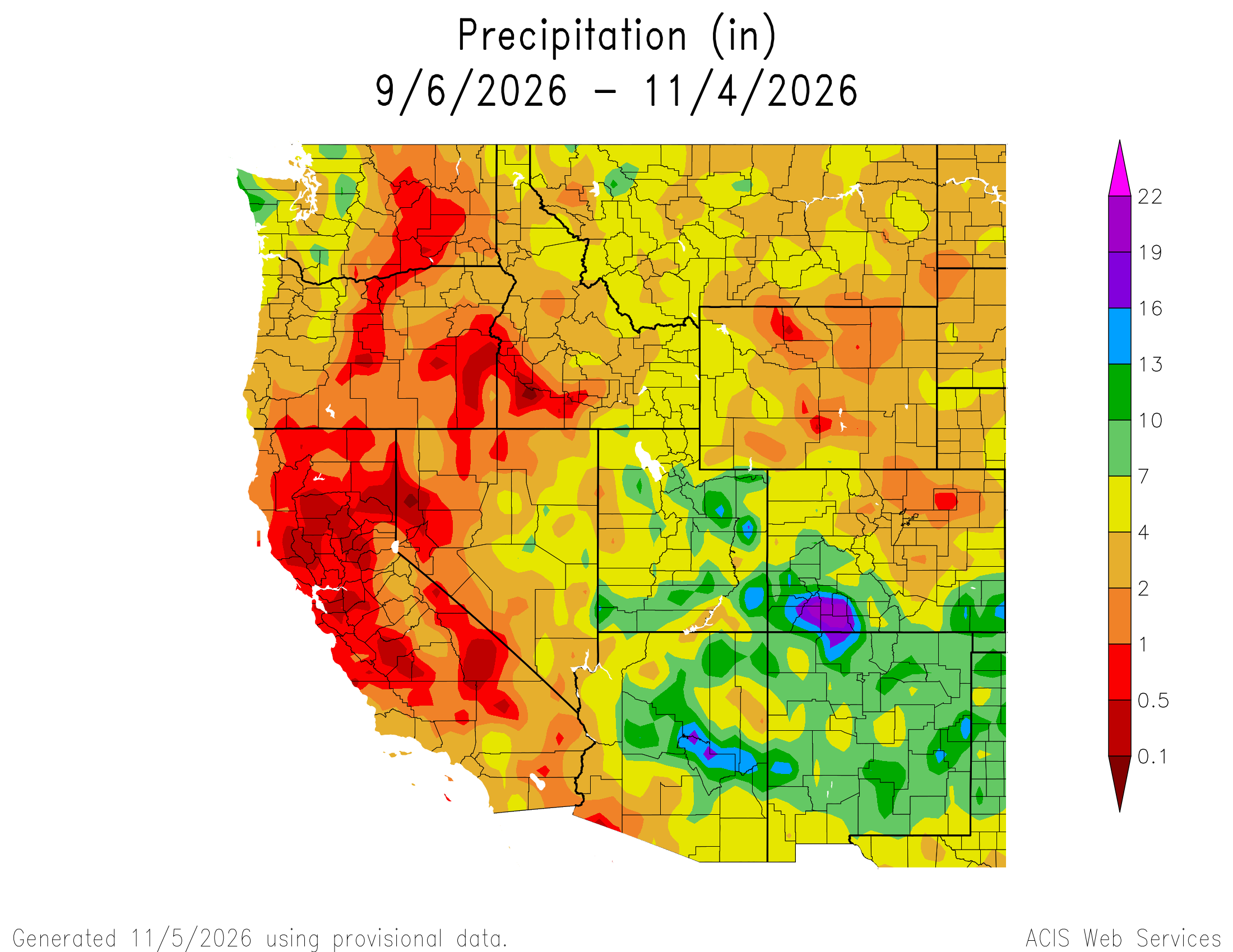
A low pressure system at an unusually low latitude for this time of year resulted in anomalously wet conditions across southern California and the Desert Southwest over Halloween weekend. During the past 60 days, precipitation has averaged well above normal (200 to 400%, or more) across southern California, southern Nevada, and most of Arizona and Utah. This fall wetness is related in part to the El Nino driven active tropical cyclone season in the East Pacific. Precipitation amounts of more than one inch prompted a 1-category improvement from Arizona north to Nevada, Utah and southeastern Idaho. Please note that short-term drought has ended for the Southwest and Great Basin. Despite multiple short-term metrics on the wet side, long-term drought of varying intensity persists across parts of these areas. Precipitation (0.5 to 1 inch, locally more) this past week led to small improvements for parts of Montana. Drought coverage and intensity remained steady for the Pacific Northwest and much of California…
The remnants of Hurricane Vance in the East Pacific brought heavy rainfall to western and central Texas. A 1-category improvement was made roughly to areas that received more than 1 to 1.5 inches of rainfall. Also, SPIs at various time scales were considered. The unusually wet fall continued in New Mexico where a broad 1-category improvement was necessary. Additional improvements may be needed in subsequent weeks to be more consistent with long-term metrics. Please note that short-term drought has ended for New Mexico. Near or more than one inch of precipitation supported improvements across the western third of Oklahoma. Since this precipitation occurred on November 2nd, additional improvements may be made to a greater coverage of Oklahoma next week once a full assessment of the latest metrics is completed. The D2, D3, and D4 coverage across Arkansas, Louisiana, Mississippi, and Tennessee is generally consistent with SPEIs at various time scales and soil moisture indicators. Impact reports from Mississippi include poor to very poor pastures along with dry farm ponds. The lack of precipitation the past two months (60-day deficits of more than 4 inches) coupled with above-normal temperatures (+6 to 10 degrees F since early September) has led to rapid intensifying drought across the Lower Mississippi Valley. Heavy precipitation (1.5 to 2 inches, locally more) resulted in a 1-category improvement to southwestern Tennessee and northern Mississippi, while a 1-category degradation was warranted for northeastern Tennessee…
Looking Ahead
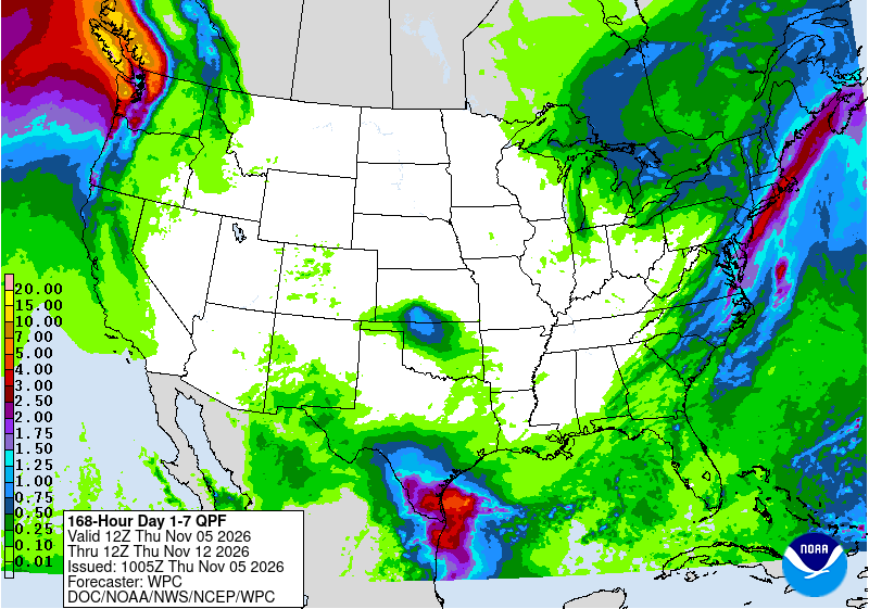
A much drier multi-day period (Nov 5-9) and more typical for fall is forecast for a majority of the lower 48 states. A cold front will trigger a period of wet weather along the East Coast with the heaviest amounts (more than one inch) from the coastal Mid-Atlantic north to southeastern New England. Along the tail end of this front, heavy precipitation may occur across the Lower Rio Grande Valley. The only other area forecast to receive significant precipitation is the coastal Pacific Northwest.
By mid-November, there is an increasing chance that an atmospheric river affects the West Coast. The NWS 6-10 day outlook (valid Nov 10-14) depicts more than a 60 percent chance of above-normal precipitation for much of California and the Pacific Northwest. The largest probabilities (> 70%) are forecast across northern California and southwestern Oregon. Above-normal precipitation is also favored across the Great Basin, Southwest, Rio Grande Valley, and Florida. Below-normal precipitation is more likely across the Northern to Central Great Plains, Midwest, and Northeast. The enhanced Pacific flow strongly favors above-normal temperatures for nearly all of the contiguous U.S. which is typical for a strong El Nino during the fall.
US Drought Monitor one week change map ending November 3, 2026.
Just for grins here’s a slideshow of early November US Drought Monitor maps for the past few years.
Click the link to read the article on the Big Pivots website (Allen Best):
November 3, 2026
Brad Udall remains hopeful a settlement will be negotiated but warns that huge changes will be needed in response to climate change. Might prior appropriation be one of them?
Colorado State University’s Brad Udall makes the case that the Colorado River Basin is the world’s first place where climate change is “forcing a complete redo of water management.”
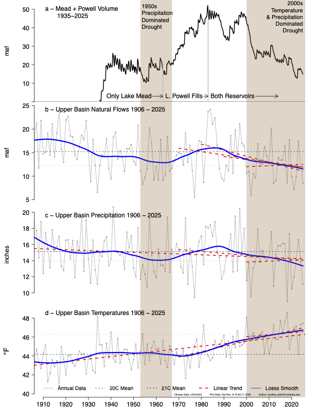
The climate change component of that statement seems unassailable. Flows in the Colorado River have declined 21% this century. A river that averaged 15.2 million acre-feet in flows during the 20thcentury has fallen to 12.2 million acre-feet in the 21st. It has further tapered off to 10 million acre-feet in the last few years.
Temperature increases of 3.3 degrees Fahrenheit since 1970 explain much of that decline. A one- degree Fahrenheit rise in temperature results in 5% loss due to increased evaporation. “Hot drought,” the phrase Udall favors, will only worsen, he says, as the process he and others call aridification will continue to worsen. Temperatures, said Udall at a recent forum, can continue to rise.
“The latest science tells us that the rate of warming has almost doubled. And the fossil fuel industry is showing no signs of exit or no signs of transformation to some other business model that doesn’t involve polluting the Earth,” he said.
Existing greenhouse gas emissions will, he added, continue to incrementally heat the Earth into the 22nd century even if humanity can reduce greenhouse gas emissions to zero.
Udall/Overpeck 4-panel Figure Colorado River temperature/precipitation/natural flows with trend. Lake Mead and Lake Powell storage. Updated through Water Year 2025. Note the tiny points on the annual data so that you can flyspeck the individual years. Credit: Brad Udall
As for the water management redo, it’s still early. Colorado River runoff has been in decline for the last quarter-century. California and Arizona, the two lower-basin states with great thirst, were able to live off water banked in the two giant reservoirs, Mead and Powell, for many of those years. Only as the storage has ratcheted down to dangerously low levels have meaningful reductions in use begun, some only temporary in nature but others permanent.
The two states plus Nevada last year used about 6.8 million acre-feet from the river, less than the 7.5 million apportioned them the Colorado River Compact of 1922 and far less than the 8.5 million acre-feet they had averaged for several decades.
Upper-basin states had also been allotted 7.5 million acre-feet by the 1922 compact, but they have never come close to using that much water. Lacking the certainty of large upstream reservoirs, they have used about 4.5 million acre-feet.
Big cuts ahead
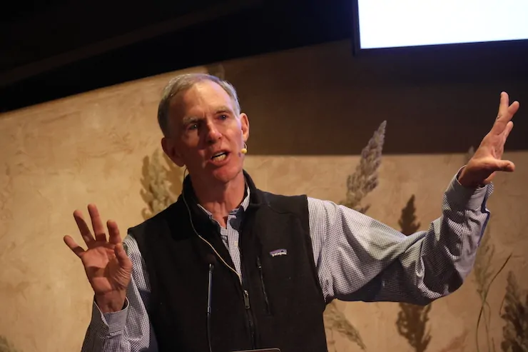
But big changes necessarily lie ahead, certainly for the lower-basin states but also Colorado and the other upper-basin states, Udall said in in a recent 90-minute plus presentation called “Dancing with Deadpool: a 27-Year-Long Colorado River Crisis.” The forum in Jefferson County was sponsored by the Colorado Renewable Energy Society and New Energy Colorado.
“We gotta get rid of those old agreements,” said Udall, the senior water and climate research scientist/scholar at Colorado Water Center.
“We in the Upper Basin must share this risk and not increase our use. The Lower Basin needs to plan on bigger cuts, more than 3 million acre-feet,” he said, citing a paper he co-authored called “What will it take to stabilize the Colorado River?” that was published in 2022 in Science. In addition, he wrote a related paper along with New Mexico’s John Fleck that iin 2021 was published in Science.
“Ag has to bear the brunt of the cuts, because they’re 75% of the use, but M and I have to help,” he said, referring to agriculture, municipal and industrial.
Strong disagreements exist between the two basins, upper and lower, beyond a general agreement to cut 1.2 million acre-feet in use. “The lower Basin really wants the Upper Basin to share, maybe on the order of 200,000 acre-feet a year, maybe 5%. And the Upper Basin says no way, and until recently has said we’re going to even increase our use. “
Native America in the Colorado River Basin. Credit: USBR
Amidst all this, the claims of the 30 or so tribes in the basin need to be resolved. A 1907 Supreme Court ruling found that when the U.S. government ordered Native Americans onto reservations that it guaranteed them the water necessary to be farmers. They control about 25% of the water with some claims, importantly those of the Navajo Nation, still in question. “Tribal water is a really big deal,” said Udall.
And Arizona, he said, with two-thirds of tribes, has a disproportionate burden of figuring out how to satisfy rights of the tribes while making everything else work reasonably well, too.
Arizona, he emphasized, is “central to the problem and central to the solution.” The Central Arizona Project will necessarily get less water, but it will not be zero, he added.
As for the unprecedented low river flows — and unprecedented high temperatures — of the 2025-26 water year, he predicted “it won’t be the last time we see this. When it comes back, it’ll be worse.”
As Udall spoke those words, it was raining hard in Colorado’s San Juan Mountains, water that helped raise the water levels of Lake Powell by about 15 feet going into November compared to a mid-September low. Still, Powell was little more than 25% full. The Colorado River problems go far deeper than can be solved by even an extraordinary storm cycle.
“True,” said Kathryn Sorensen, director of research at Arizona State University’s Kyle Center for Water Research, responding to a New York Times story posted today, “but they’ve helped pull us from the brink at Lake Powell, doubling or perhaps tripling the amount of realistically accessible storage there.”
Prior appropriation
Many analyists have concluded that the doctrine of prior appropriation, the legal structure for determining who gets how much water and when, must be modified. It is commonly called first in time, first in right.
The lower basin has roughly 100 diversions, nearly all very large and many of them administered through use of federal infrastructure. There, this principle is less important than in the upper basin, which has thousands and thousands of diversions, many small. Even so, it is the basic principle that allows California a bigger ladle for the Colorado River than Arizona. Arizona got in line as a result of federal legislation in 1968, the Colorado River Basin Project Act.
That law stipulated that water for the Central Arizona Project would be subordinate to California’s 4.4 million acre-foot annual allocation in case of shortage.
Prior appropriation “doesn’t really fit with the 21st century,” said Udall. He described it as a “winner take all” legal system developed in the 18th century by the farmers and miners who were the first colonists of Colorado and other parts of the West.
“You know, first in time makes first in right,” he explained. “And I argue all the time that 4-year-olds around the globe discover this rule every day. ‘It’s mine. I was here first.’ And most parents step in and say, ‘No, no, you need to share that.’ That’s the system we have. And some people now own vastly expensive water rights because of this, and we’re not going to overturn it.”
The doctrine did, he conceded, make sense in the 20th century. “If you were a junior water right holder, you could actually develop resilience and firm that water right by building storage, so that in really big years you’d capture some water. And then, in the low years, when you weren’t entitled to any water, you’d use your storage to make up that deficient. Well, in a climate change world, that strategy now becomes next to impossible to deal with. Because we don’t have these big years to fill up your reservoirs.”
The doctrine is “embedded in how the Colorado River works, including the Central Arizona Project and its junior status to California,” he continued. “Agricultural rights are generally senior to cities, and … this creates problems because you end up potentially with a situation where Denver could get called out by agricultural water rights on the West Slope” of Colorado, especially those ag rights with appropriation dates prior to the Colorado River Compact.
“I’ve been arguing that we can’t have 1,500 farmers depriving 20 million people in California and 7 million in Arizona and 2 million in Nevada and 2 million in Colorado with these senior rights,” he said.
In 2010, working with Jonathan Overpeck, a researcher then affiliated with the University of Arizona (and now Michigan), Udall had begun to warn of dry times ahead. In a paper published in 2017 by Water Resources Research called “The twenty-first century Colorado River hot drought and implications for the future,” they predicted 20% losses in river flows by mid-century and 35% by end of century. Those, they said, were conservative estimates.
The backstory is that for nearly a century the Colorado River Basin states — importantly abetted by the federal treasury — had created the infrastructure that assumed far more water even than what optimistically was assumed by the Colorado River Compact of 1922.
Deep family history
Udall brings to the Colorado River discussion perspectives informed by his unusual circumstances.
“I’m a great -great grandson of John D. Lee, the founder of Lee’s Ferry,” Brad at his presentation on Oct. 22. “You might think that’s kind of special. Turns out Lee had 21 wives, and there’s a chance he had 800,000 descendants, which might in fact be part of the problem right now.”
A long-time resident of Colorado, Brad grew up in Arizona, the son of Morris Udall, who represented Arizona in the U.S. House of Representatives from 1961 to 1991. His uncle Stewart Udall had represented the same district before becoming the secretary of Interior in the Kennedy and Johnson administrations from 1961 to 1969.
In other words, Udall’s relatives were involved in creating at least some of the agreement infrastructure that now looks ill-advised. That includes the Central Arizona Project, which delivers Colorado River water via a system of canals and pipes that pumps water up 3,000 feet in elevation and across 336 miles to Phoenix, Tucson and farms between. Even then, during the debate in the 1960s, Mo Udall and other supporters realized the Colorado River would not have sufficient water. They were betting that water could be imported, such as from the Snake River in Wyoming’s Jackson Hole. That never flew.
“I think Stewart and Mo sort of blew it on some of this,” Brad told Hager. But he also counseled some compassion. They had grown up on a farm in Arizona during the Great Depression. By the time they came to power after World War II, an era of booming national optimism may have colored their political thinking.
“The 1968 idea was we could build our way out of anything,” Brad said. “We could engineer our way out of every crisis. We’re smart. We’re rich. The world’s our oyster.”
Udall gives many slide shows, each building on the last one. The best of them need at least an hour to deliver, because the story is that complicated. This was the third presentation by Udall heard this year by this writer. Unlike some others, though, this audience consisted of people most attentive to the energy transition. To his credit, Udall was able to craft his presentation in a way that did not require vast knowledge of the arcane world of water. He did this without sacrificing details.
Udall sees himself as a truth-teller with an unpleasant message. “As a scientist, I kind of feel like it’s my job to tell people how it is. And if I can tell it with a little humor and a smile on my face, even if it’s a tough message, maybe they’ll hear that message,” he said.
The truth he sought to share was the need for great changes in how this declining source of water is shared by 40 million people — changes necessary very, very soon. Those changes will likely include Colorado and other headwaters states, probably an agreement to conservation measures that reduce use by 2% to 5%.
Important, he said, will be better accounting of volumes of use in the upper-basin states. Lacking hard numbers, it’s hard to judge equities. The counter argument has been that Colorado, in particular, has so many small users that this accounting poses an extremely difficult challenge.
What also must be noted is that Udall’s critique inevitably is easier to deliver than setting out a precise outline of what this new future must entail. That, of course, likely would have required another hour or more.
“I still think we’ll get a negotiated solution,” he said as he wrapped up his presentation. But then he added an asterisk, referencing the lawsuit filed by first Nevada in August, then joined by Arizona in October, challenging the federal government’s order for cuts in water use. “Although every day these lawsuits continue I get more depressed,” he added.
After Udall’s presentation, in the cafeteria where munchies were delivered, I heard one listener who suggested that Phil Weiser, when governor, might consider making Udall the representative of Colorado on the Upper Colorado River Commission. That is not a rap against Becky Mitchell, the current representative, who by all accounts has represented Colorado well in the difficult discussions. It is, though, an interesting idea.
In late October, 100 people turned out at the Unitarian Church between Wheat Ridge and Golden to hear Brad Udall share his thought and knowledge about the Colorado River.
Following are a few more highlights:
Fuzziness of 1922 compact
The 1922 compact has several fuzzy components, most troubling being what was meant in Article 3D, the non-depletion clause, which says the upper basin states “will not cause” the flows at Lee Ferry to drop below 75 million acre-feet across every rolling 10-year average.
“In the 20th century, there was only one way for that number to fall below 75 million. acre-feet, and that was if the basin used the water. But in the 21st century, we have a second way for those flows to fall below 75 million acre-feet, which is climate change, of course, and no one knows what this (delivery obligation) means,” said Udall.
Too, the compact “totally excluded tribal water rights, despite a critically important Supreme Court decree in 1908 (Winters Doctrine), saying that tribes were entitled to water.”
As for the abundance of annual flows in the river, “They actually thought in 1922 that they were going to come back in 1962 and allocate a whole bunch of water because they hadn’t allocated all of it.”
On deadpan
“There would be real harm if we hit deadpool. I mean, there would be a lot of people hurt. You hit Deadpool, you turn control of these reservoirs over to Mother Nature, away from us, and that’s a fundamental mistake.”
Getting into the mess
“We’ve made a whole bunch of mistakes through time,” he said. “We allocated water permanently. We assumed too much water. And there are a whole bunch of unrealistic policies. We now have a solution in sight for the next two years, but it will not be enough. And litigation (Nevada and now Arizona suing the federal government) just announced clouds what might really happen.”
Musical chairs
While the compact apportioned 7.5 million acre-feet to the upper basins states, they have never used more than 5.5 million acre-feet and mostly have stuck to around 4.5 million ace-feet.
“They feel like they’re still entitled to it, but it’s also a little bit of a game of musical chairs, right? I mean, the music stopped here, and because you never grew into that, it’s really hard to figure out how you possibly can use more given the facts on the ground., We’re sitting on a 2 million acre-feet per year imbalance.”
An acre-foot
An acre-foot is 325,000 gallons of water, enough for 10 people for a year. In the upper basin, a farmer might put one or two acre-feet of water on top of a field to get a crop of hay in the summer. In Arizona and California, where it’s hot, they might put 10 feet on top of their field to get 10 different cuttings of alfalfa.
A high desert thunderstorm lights up the sky behind Glen Canyon Dam — Photo USBR
The big reservoirs
In January 2000, Powell and Mead were about 95% full, with 47 million acre-feet. In August 2026, they were 24% full.
No analog
Our high-flow years on Colorado River are now half as frequent, and our low-flow years are about two and a half times as common. “The take-home here is that there’s no analog in the 20th century to what we’re seeing now,” he said.
Colorado, the headwaters
Of the water that originates in Colorado, 90% flows out of the state.
Map of the Colorado River drainage basin, created using USGS data. By Shannon1 Creative Commons Attribution-Share Alike 4.0