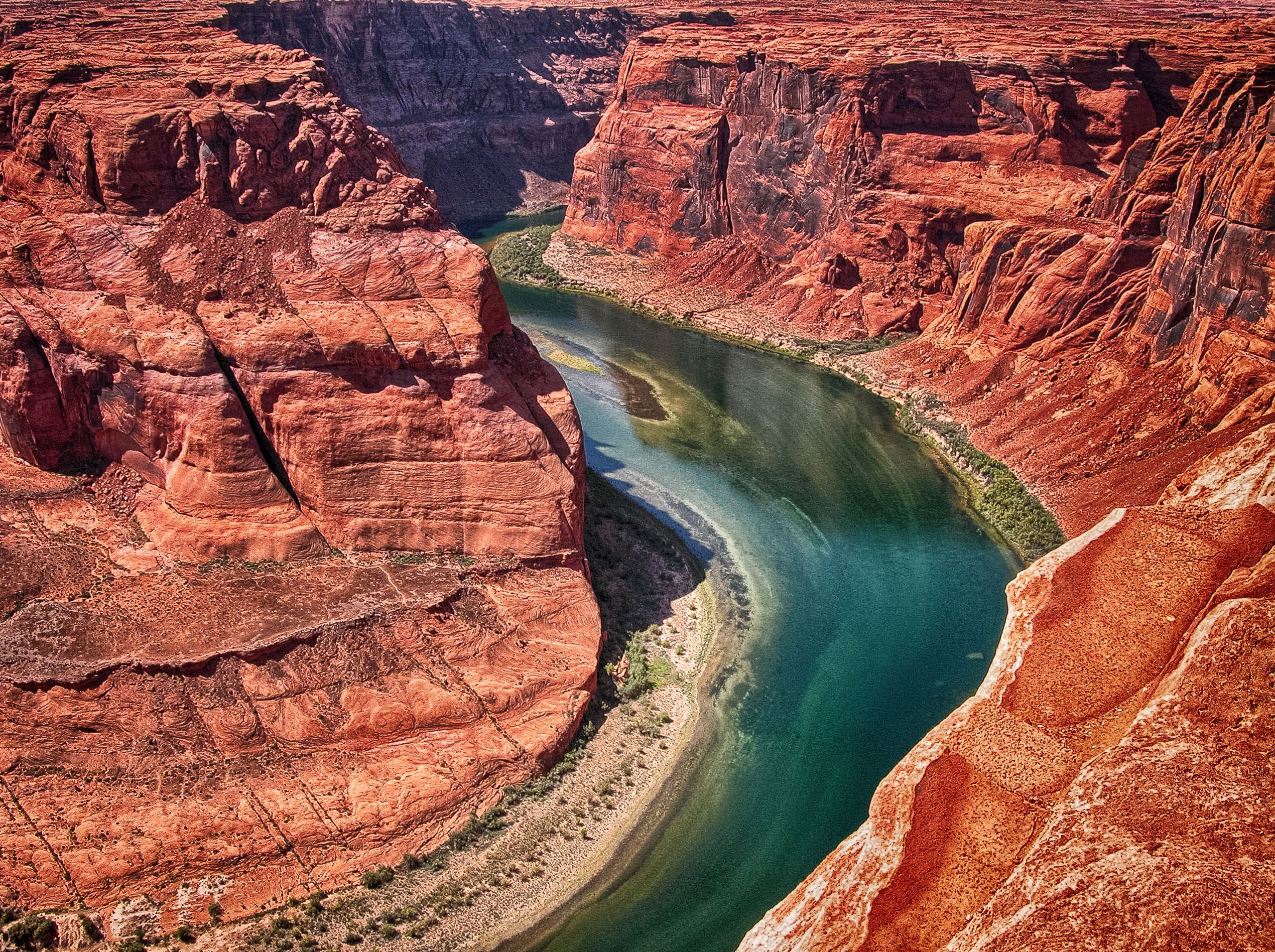
Ken Sleight may be most well known for something that he probably never did: kneeling on the bridge in front of the Glen Canyon Dam, his hands clasped and eyes closed, praying to the Almighty to produce a “precision-type earthquake” that would free the Colorado River from its imprisonment in Lake Powell. The Sleight-inspired character Seldom Seen Smith acted out the scene in “The Monkey Wrench Gang,” Edward Abbey’s 1975 cult classic of ecosabotage. But although the character was fictional, Sleight’s lifelong hatred of the dam was very real, as was his love of Glen Canyon, the area drowned by Lake Powell.
“It was Glen Canyon that changed my whole life,” Sleight told The Salt Lake Tribune in 2018. “It made an environmentalist out of me.”
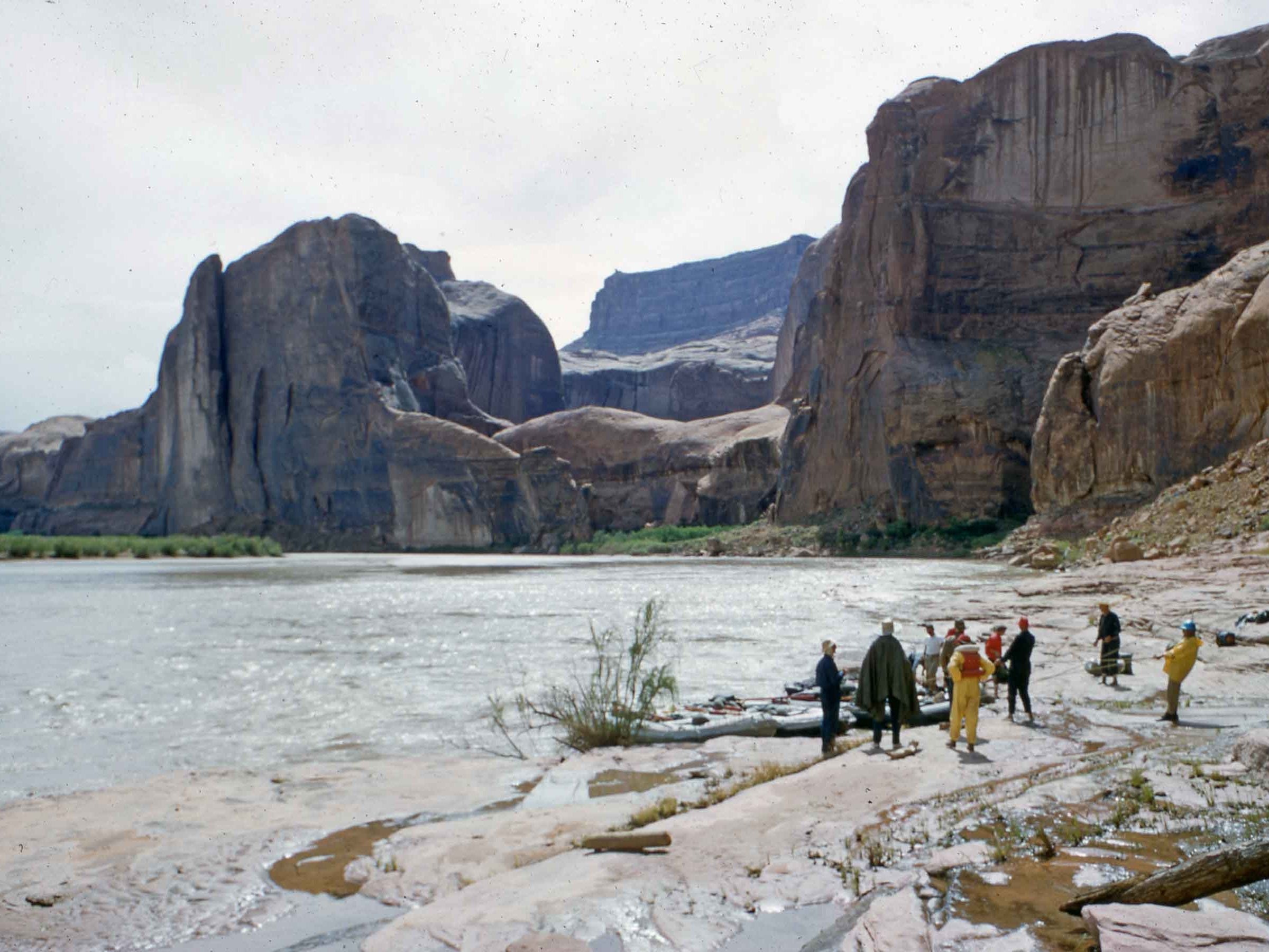
(Photo by H. Bennett. Courtesy of Ken Sleight.) Ken Sleight making breakfast along the river in Glen Canyon before the dam, circa June 1960.
[…]
In 1957, Sleight purchased eight Army surplus rafts, quit the tire business, and opened a river guiding company that would soon take the name Ken Sleight Expeditions. For the next six years, Sleight led river trips through Glen Canyon on the Colorado River where he showed artists, environmentalists, reporters and curious members of the public the labyrinthine sandstone canyon country that would soon be flooded by Lake Powell…He found common cause with the writer Edward Abbey when the two met in 1967 at the Lees Ferry boat ramp. Sleight was launching on a Grand Canyon trip, and Abbey, who was working as a ranger for the National Park Service, helped Sleight rig his boats.
“[We] sat on the edge of the raft talking and thinking, eating and drinking until the wee hours of the morning,” Sleight would later write, “making creative commentary on how best to eliminate the Glen Canyon Dam.”
The friendship lasted through Abbey’s death in 1989, and Sleight never seemed to mind being immortalized as the anarchist Seldom Seen Smith. Sleight often said that Abbey was able to put into words his anger and sorrow over seeing Glen Canyon flooded and so many other wild places transformed by development…Even though Sleight took on numerous environmental and political fights, he never forgot about Glen Canyon, which he often used religious terms to describe.
“I’d still like to see the water from the reservoir — what I call Lake Foul — I think it all ought to be drained and the water be flushed downstream to be stored in Lake Mead,” Sleight told The Tribune in 2021. “One thing is for sure: We’re still trying to resurrect Glen Canyon.”
Ken Sleight the original Monkey Wrencher photo via Salon
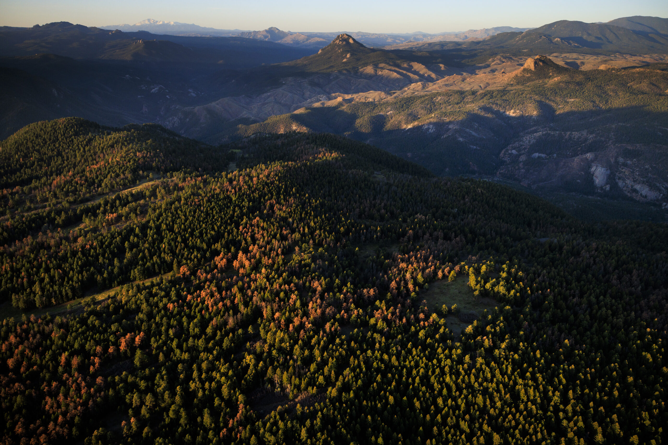
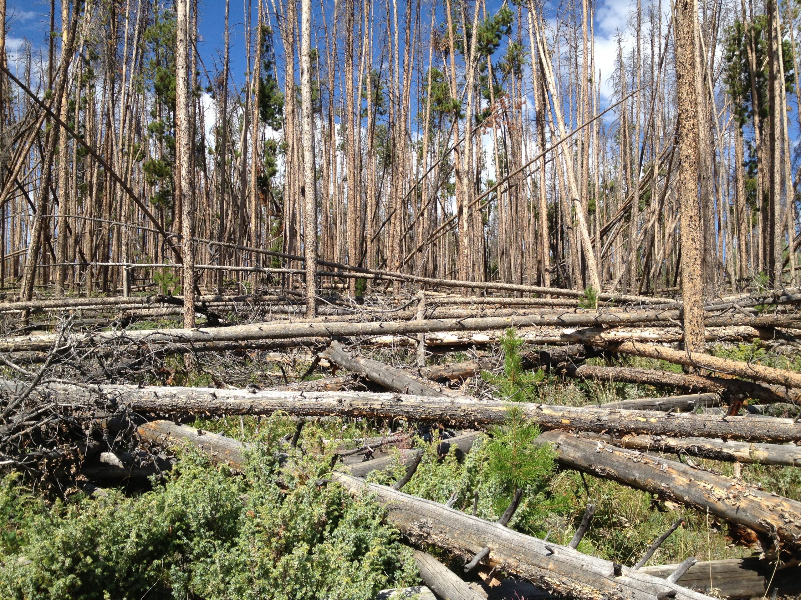
Pine trees killed by mountain pine beetles cover the hillside on Tuesday, May 12, 2026 near Foxton, Colorado. Ponderosa pine forests in Colorado’s Rocky Mountains are experiencing elevated mortality rates from the pine beetles as their populations expand in part due to a warming climate and drought conditions. (Photo by Michael Ciaglo/Capital and Main/LightHawk)
The white Cessna banked right to reveal dense forests of Douglas fir, pines and quaking aspen in varying shades of green bathed in the early morning light. Yet secreted under the layered bark of some pines is a pest whose upcoming flight places Colorado’s highest concentration of real estate and infrastructure values at risk.
Damage wrought by the mountain pine beetle is already evident in thousands of dead and dying red-needled ponderosa pine knitted throughout these stands. Their gray skeletons line highways, heighten already elevated wildfire risk and threaten watersheds that millions of residents rely on for clean drinking water.
On some mountain properties about 40 miles west of Denver most every pine is dead. Many residents cannot afford to remove the infested century-old ponderosas. One quote ran $15,000 an acre. The growing price tag to mitigate the damage and protect high-value trees from the next onslaught presents a quandary for local, state and federal agencies.
An historic drought weakened ponderosa pines, allowing the beetles to chew their way through hillsides of trees bordering mountain towns at the gateway to popular ski areas and hiking trails. Impacted acreage increased 148% to 5,544 acres in 2025, when compared with 2024, alarming foresters, communities and lawmakers.
This year, the breadth of the insect’s footprint and the intensity of its attack is expected to expand exponentially. At stake: More than 600,000 acres of ponderosa pine forest woven throughout areas where about 4 million people live in nine counties on both sides of the Rocky Mountains.
“We anticipate there to be anywhere from twice as much, to three times as much, activity as we saw last year,” Dan West, an entomologist with the Colorado State Forest Service, told Capital & Main in June.
“That is startling.”
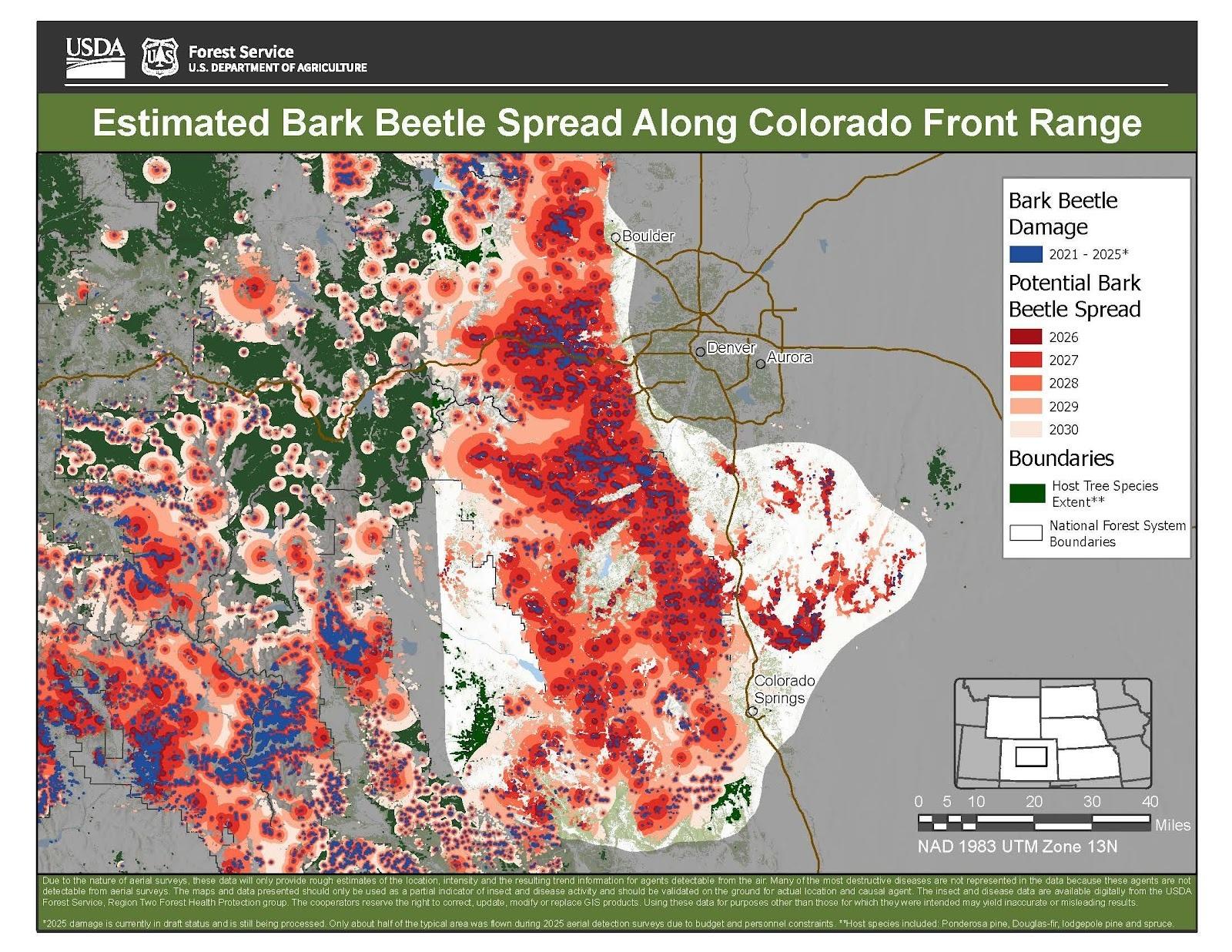
A U.S. Forest Service map of the endemic pest’s potential to spread through 2030 is equally startling: Dark red blotches indicating infestation intensity cover forests at every latitude from Boulder, north of Denver, to the Black Forest, where high-end suburbs hug Colorado Springs, to areas behind Pikes Peak to the south. The counties most at risk contain thousands of acres of ponderosas. Some of the pines sit just outside the state’s Capitol.
To minimize the spread, foresters are prioritizing early detection and response. It’s no easy task. Forests harbor twice as many trees as those better able to resist a beetle outbreak. A century of fire suppression and more intense and extreme weather caused by heat-trapping emissions from expanding oil and gas extraction in Colorado and elsewhere contributed to the dire outlook.
Across the country, climate change is ravaging ecosystems, bringing more robust storms, rising sea levels, record-setting conflagrations and fatal heat waves. In Colorado, the staggering die-off of the majestic pines is difficult to stomach.
To track the outbreak, West regularly hikes to infected stands to inspect last year’s broods. What he found this spring surprised him: Females who burrowed into large green trees in 2025 laid double the number of larvae the scientist observed in previous infestations. The lack of sub-zero temperatures this winter — which marked the state’s lowest snowpack on record — ensured their survival.
Peeling the bark off ponderosa pines with his hatchet, West counted between 60 and 120 larvae coming off each female pine beetle. The insects tunnel their way into the trunk, impeding the tree’s water and nutrient supply and killing it within a year. During wetter years, trees are healthier and can more easily repel the beetle with sap. This year, many are defenseless against the rice-sized insect’s relentless assault.
Mountain Pine Beetle kill via USGS.
Its small stature belies its ability to wreak havoc. The last major outbreak, which spanned 1996 to 2013 and decimated about 82%, or about 3.4 million acres, of the state’s pine forests, is fresh in Coloradans’ minds. In some ski communities, such as Winter Park, entire mountainsides of trees perished, dramatically altering the landscape.
The Cameron Peak fire soon after it started on Aug. 13, 2020. By Sept. 11, the fire had grown to more than 102,000 acres (now >200,000 acres) and was not expected to be considered out until Oct. 31. Photo credit: InciWeb via The Colorado SunEast Troublesome Fire. Photo credit: Northern Water
Dead lodgepole pines intensified the two largest wildfires in state history in 2020. The Cameron Peak Fire swept through 326 square miles of forest in Larimer and Jackson counties and Rocky Mountain National Park, along with 492 structures, while the East Troublesome Fire burned through Grand County and Rocky Mountain National Park, reducing to ash over 300 square miles and 500 structures and killing two.
The insects started to migrate from higher elevations to coniferous forests, but a historic 2013 rainstorm stopped their advance. Now, following the state’s warmest climatological spring on record, the beetles are poised again to expand their territory.
Left: Pitch tubes, small nodules of yellowish-red sap, are an external sign of a beetle infestation. Photo: Steve Rudolph, CSFS. Right: Bark removed from a lodgepole pine tree reveals burrowing mountain pine beetles. Photo: CSFS.
Their advance threatens Denver Water’s 2.5 million acre watershed — at least a quarter of which is covered with ponderosa pine. The utility has spent $96 million since 2010 to restore forests in this region, including spraying some pines in hopes of protecting them from infestation, said Madelene McDonald, watershed planning manager.
“The threat of high intensity wildfire is not theoretical — it’s one we’ve experienced,” she added. “High intensity fires lead to brown, sediment-laden water flowing into treatment plants, which is really expensive to treat.”
McDonald is among 39 people who sit on a Ponderosa Mountain Pine Beetle Task Force created by an executive order Democratic Gov. Jared Polis issued in December after West, the entomologist, and the state forester warned him to get ahead of the outbreak.
The governor stressed an urgent need to educate residents, protect high value pines and prioritize the removal of diseased trees that harbor broods. This work must be planned around the insect’s annual flight to find new trees between June and September. The task force is charged with quickly mobilizing resources to mitigate the infestation, which has overwhelmed residents and muncipalities alike.
“It’s hard emotionally as somebody who cares deeply about our forests — in areas of our district there’s not a tree left,” said Jess Moore, wildland project coordinator for Evergreen Fire & Rescue. “We encourage homeowners to reach out to contractors, arborists and foresters so they can get the best support they can to protect their current trees.” The “sheer volume of impact” has prompted some residents to take such steps, and to thin their trees, she said.
It’s expensive and time consuming. Just ask retired environmental science professor Harv Teitelbaum, who lives in Evergreen on a wooded property that’s long, narrow and hilly. He teaches people how to climb trees, including pines. Yet the infestation required him, with the help of volunteers and a tree care service, to remove 45 ponderosas from his land. The bill: $10,000. Another 40 or so are dead or dying.
“This has been a lot more devastating — in the past, you would have isolated trees here or there that were killed,” he said. “This is more widespread.”
A few years ago, Teitelbaum lost his favorite training tree, a ponderosa nicknamed “Gramps,” to the beetle. This year, to protect his remaining pines he stapled pheromone packets to their trunks and injected some with a chemical treatment. He hopes it works so he can continue to train new generations to climb on his property.
“Up there, you see a country you haven’t seen,” he said. “The tree is a living, breathing thing. You feel it swaying, and you’re breathing oxygen it’s giving off from its crown.”
About a dozen miles south near Conifer, Brad Huddleston used similar methods to protect pines on his property. The arborist founded Splintered Forest, a fire mitigation company, 22 years ago after losing his family home in a wildfire. He advises clients to inject large pines with insecticide before the tree’s green needles start to change color. The every-other-year treatment runs up to $300 per tree. Pheromone packets and spraying, which cost up to $25 a tree, are other alternatives. The pheromone treatments release a scent that tricks beetles into thinking a tree is full, causing them to go elsewhere.
“A lot of homeowners take solace when I tell them that despite them seeing major beetle destruction along our two main corridors, their properties are not destined for the same thing,” he said. “We can turn the tide on individual trees.”
Trees killed by mountain pine beetles crisscross the forest floor in Grand County. Photo: CSFS.
Huddleston’s company has been busy removing hazardous diseased trees near homes and access roads and thinning overgrown stands. The downed wood must be covered to smother the beetle, or hauled away to sites designed to handle infested timber, known as “hot logs.”
Such work increased this year. Jefferson County, home to both Evergreen and Conifer, collected 10.3 million pounds of slash, or woody debris, in 2025, up from 9.5 million in 2024. The response underscored the stakes — the region’s wildfire risk is 98% higher than that of counties nationwide, said Jefferson County Commissioner Lesley Dahlkemper, who is the Democratic nominee for lieutenant governor.
“I went to a recent breakfast at the Conifer Chamber of Commerce, and the scale of the crisis and how its impacting constituents became crystal clear,” she recounted. “I asked who was dealing with mountain pine beetles on their land and every hand went up.”
Little infrastructure exists statewide to accommodate the amount of wood now coming off properties. The dry winter prompted counties statewide to ban slash burning, which some rural landowners rely on in part to dispose of beetle-kill. This practice allows property owners to burn small piles of wood on their property, in some cases with a permit and during certain weather conditions.
Clear Creek watershed. Credit: Upper Clear Creek Watershed Association
In smaller counties, a reduced tax base provides officials no wiggle room for mitigation funding. About 24 miles northwest of Conifer in Idaho Springs, lawmakers are seeking funds to mitigate the damage and to take protective measures. Of major concern is the stability of the Clear Creek Watershed, which 450,000 people rely on for drinking water.
“We are kind of raising the flag — we just need more work, faster,” said George Marlin, a Clear Creek County commissioner. “It’s complicated to accomplish mitigation on interlocking federal, state and private land — we need all of these entities to have adequate funding to get it done.”
The challenge Marlin and his colleagues face is evident from the white Cessna’s window. Red and brown ponderosas crown hillsides ringing the former mining town. The mosaic prompted pilot Evan Anderman, a volunteer with LightHawk, a nonprofit that works with pilots who donate their time and aircraft for conservation causes, to bank his craft yet again.
What’s most worrisome is not yet visible from his aircraft. For every red tree, there are between 2½ and 10 green infested trees. In the early stages of infestation, these trees are only identifiable by sawdust at their base, sap on the trunk, or tunnels under the bark. West urges homeowners to prioritize these trees for removal.
Residents in Jefferson and Clear Creek counties are getting the message. People in both areas approved tax increases in 2025 for fire protection services. Identifying additional funding for wildfire mitigation is among action items Polis’ task force included in a June 30 work plan. The document identified numerous gaps in the current outbreak response.
These included “fragmented public communication,” inconsistent coordination across governmental boundaries, a constrained workforce and “uneven community and landowner engagement.” It also contained a stark warning: “The outbreak will persist for a decade or more, trees will die at a visible scale, and fire risk will remain elevated.”
Keith McMillan knows how beetle-kill influences fire risk. The former fire captain worked 21 years with Breckenridge’s Red, White & Blue Fire Protection District. The ski town lost 90% of its lodgepole pines between 1999 and 2013. Fire risk is highest when red and brown needles remain on the pines — they can help speed a blaze through the canopy, he said.
McMillan, who today is the only fire mitigation specialist for a homeowner’s association in the West, is using his experience to encourage residents in Ken-Caryl Ranch, a 4,400-home Denver subdivision, to protect their ponderosa pines.
The retired firefighter advises homeowners in what he calls an “urban forest” to spray or use pheromone packets on trees, or to remove them if they are too close to homes. It’s emotional work. People are attached to trees they planted when they moved in, or to celebrate a child’s birthday. And he doesn’t have enforcement power.
“We are trying to stay ahead of it — my No. 1 challenge is public perception” of public safety risks that accompany large tree die-offs, McMillan said. “We are just on the edge of the mountain pine beetle epidemic making it to our land.”
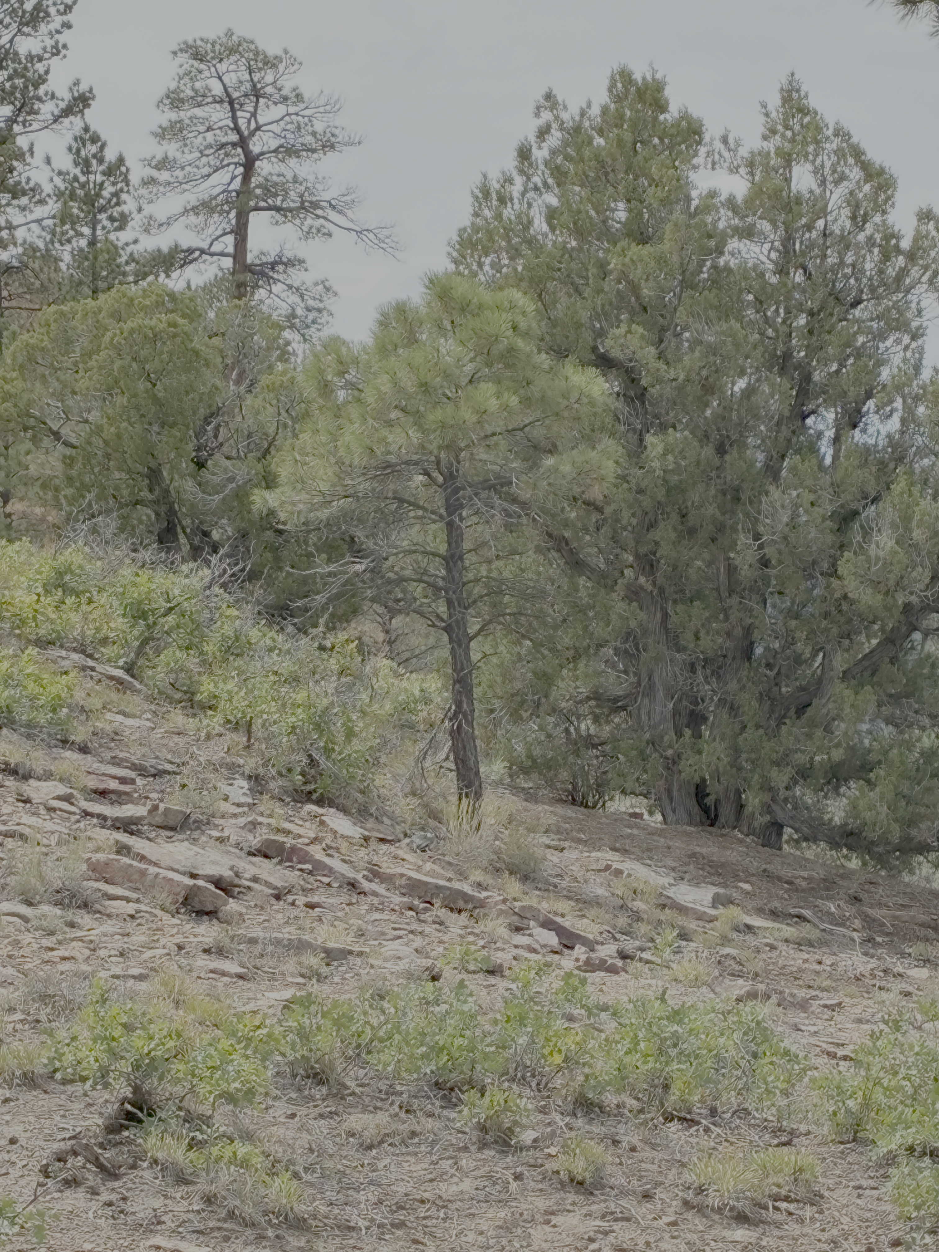
A young Ponderosa Pine at the Dolores Canyon Overlook September 16, 2026.
Utah is betting that voluntary conservation like this can help protect the state as the Colorado River shrinks and the seven states that depend on it fight over who should use less.
“We want to develop a block of water in Powell with Utah’s name on it, so if we have to do mandatory curtailment, that’s the first block of water that we have to use to meet that demand,” [Kent] Stilson said…
Those states — Arizona, California and Nevada — and Upper Basin states — Colorado, New Mexico, Utah and Wyoming — have been in tense negotiations about how to share the diminishing Colorado River. With no deal reached, the Bureau of Reclamation moved forwardwith a plan that requires the Lower Basin to conserve 1.25 million acre-feet of water next year, with steeper cuts possible in the future. The plan includes no mandatory cuts in the Upper Basin, just a goal to conserve 200,000 acre-feet per year. Given the Upper Basin’s limited conservation in the past, that’s a “very ambitious goal,” said Eric Kuhn, retired manager of the Colorado River Water Conservation District. The burden of conservation has been a major sticking point among the states: if the Lower Basin has to take cuts, those states want the Upper Basin to commit to measurable conservation. But Utah and its neighbors argue that Mother Nature already forces shortages in dry years. If states can’t agree, the Lower Basin could sue the Upper Basin over the Colorado River Compact in an attempt to force cuts to water use. So Utah is preparing. By paying water users to temporarily send water downstream, it’s hoping to bank credit to pay for future cuts.
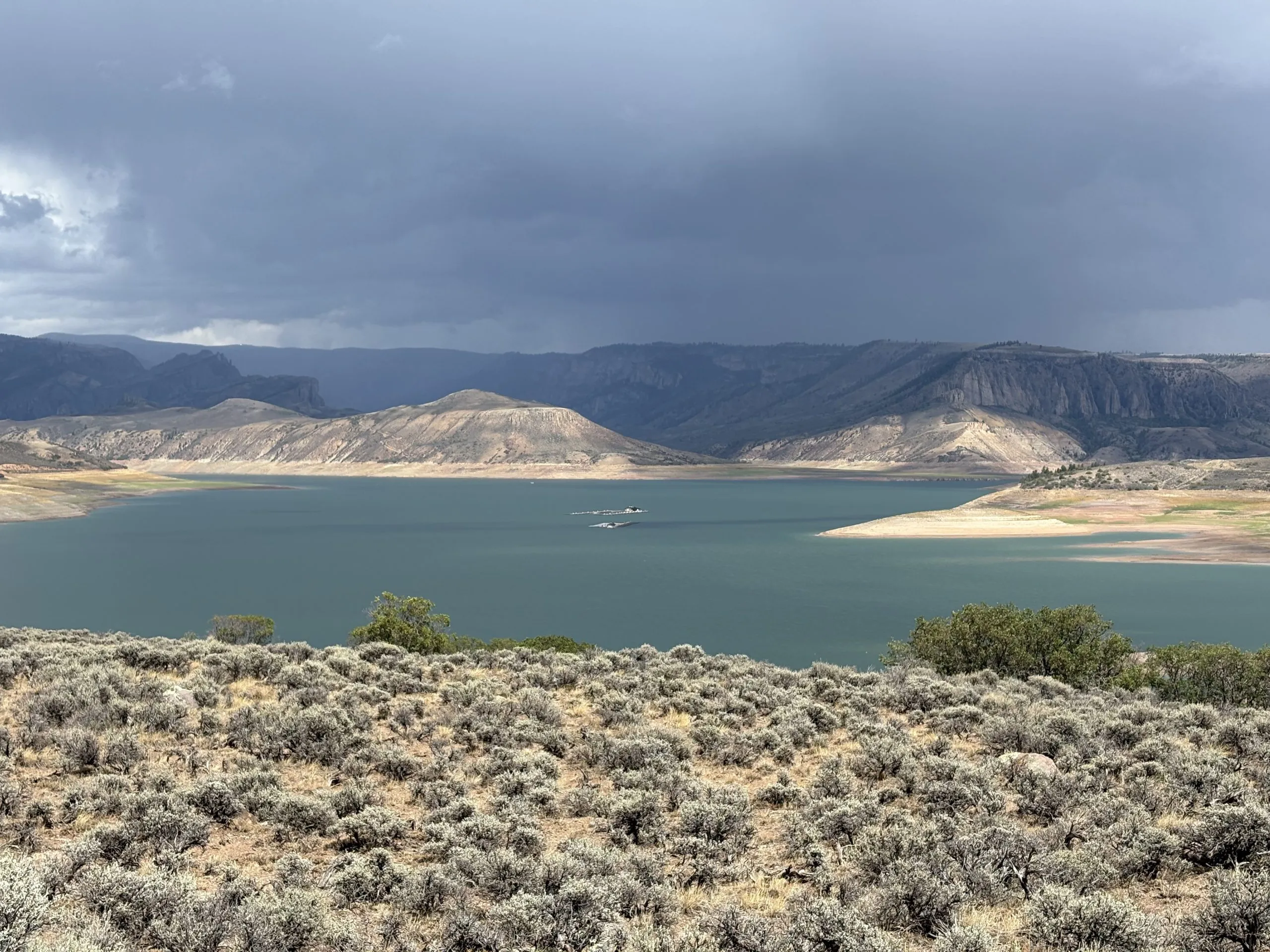
Anyone can see that something is deeply wrong at Blue Mesa Reservoir on the Western Slope. It’s historically been the biggest body of water in the state. But not anymore. The deep, long-lasting drought has shrunk it so much it lost that title to Lake Granby up north. Now it looks like someone’s opened the drain on a gigantic, rocky bathtub, with only a bit of shiny blue water pooled at the bottom…For 60 years, Blue Mesa Reservoir has stored water that flows to communities and generates electricity. It’s also a popular recreation spot, a 20-mile-long lake sandwiched between Montrose and Gunnison. Growing up on the edge of this vital water source, Riser has watched decades of visitors bobbing on their motorboats and jet skis, with their coolers and kids, dogs and music…Del Piccolo said he’s never seen algae “that blue and vibrant.”[…]The neon-blue algae is like a warning sign of just how bad things are at Blue Mesa. There are actual warning signs posted, too, saying the water is now dangerous to people and pets. Sonja Chavez, executive director of the Upper Gunnison River Water Conservancy District, thinks it’s the worst Blue Mesa has ever looked…
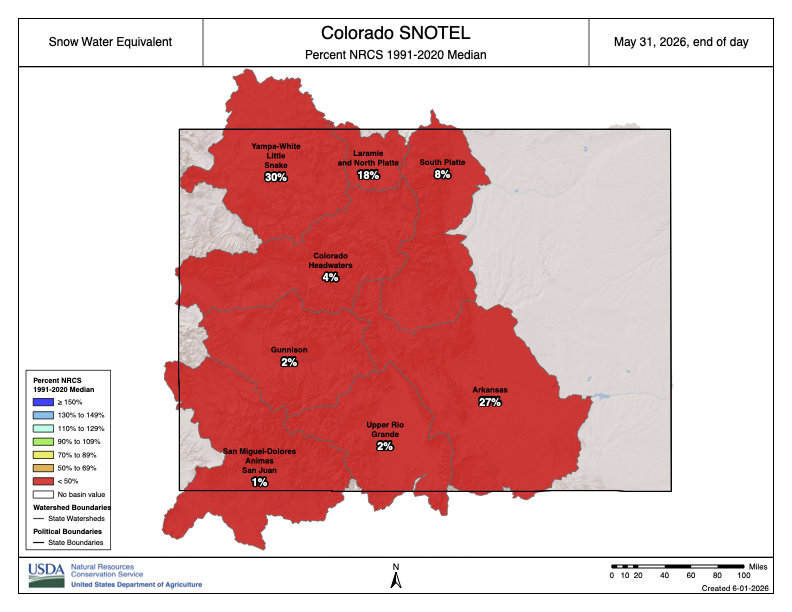
Colorado SNOTEL basin-filled map May 31, 2026.
Blue Mesa is not a naturally occurring lake but instead is man-made, designed by the federal government to store water for downstream communities, farms and ranches. It also generates electricity and is federally mandated to release water that provides habitat for threatened and endangered fish, including the native razorback sucker and humpback chub. Federal officials take all of that into consideration when they determine how much water to discharge. This year, they were faced with an abysmal snowpack — that accumulation of snow that builds up throughout the winter. Chavez believes the U.S. Bureau of Reclamation, which controls how much, and when, water flows out of Blue Mesa, needs to adjust more quickly to lean water years like this one.
Chavez thinks the BoR was releasing too much water too early in the season, which drove Blue Mesa into crisis. In an email statement, the agency said it does work from 24-month forecasts of how much water will melt into reservoirs, but that it also adjusts water releases as conditions change.
“Moving forward, Reclamation is already working with our forecasting partners and water users on ways to improve modeling for dry year water use, enhance forecasting … and review historic operations to identify opportunities for increased drought resiliency,” said Bart Deming, BoR Western Colorado Area office manager.
Click the link to read the article on Ken’s Substack (Ken Neubecker):
September 16, 2026
Walter and I frequently walk along the Colorado River in Glenwood Springs’ Two Rivers Park, where the Roaring Fork joins in. The Colorado has been running reddish brown lately due to some intense rain and blowouts from small tributaries upstream, gullies that normally are dry. Not this summer. The Roaring Fork runs clear, creating a distinct division between the flows, a narrow ribbon of clear cold water that runs alongside the warmer and muddier stream for a long ways before they mix.
Both streams and most others are extremely low, even for late summer. Many of the USGS gauges have exclamation points next to them on the map, meaning “extremely below average”. There are rocks exposed to the air that I’ve never seen before. What little monsoon rain we had didn’t do anything, not even for the dry soils that will likely soak up much of the snow melt next spring before it can reach the rivers.
Years ago when I’d go to water meetings and conferences, back when people referred to our current situation as an unusually long drought, there was some talk about the Colorado River Compact’s requirement that the Upper Basin not cause the river flow to drop below 75 million acre feet (maf) over a ten year running average. Oh, we’ll see that train wreck coming with plenty of time to do something, they all said. That train wreck is now happening. The engine is sliding over the cliff as the States argue about the menu back in the dining car. All that really happened was serious can kicking along the tracks.
The first Upper Basin “tripwire” of 82.5 maf, the 75 maf plus 7.5 maf for Mexico could come as soon as next month. Now the can being kicked is full of lawyers.
So, what does the 1922 Compact actually say? The meat is in Article III:
This is what each basin could expect every year.
This is where the additional 1.5 maf per year, split as 750,000 acre feet due from each basin comes in. There was no agreement on Mexico’s share of the river in 1922, or in 1928 when the Compact was finally ratified. That came in 1944 with a formal treaty regarding Mexico’s share in both the Colorado and Rio Grande Rivers. The Compact negotiators anticipated such an agreement, hence paragraph (c). What they didn’t anticipate were decades of no “surplus”. That’s another story.
The more serious tripwire comes next:
October 1, 2026, may well see the flow at Lee Ferry cross the first line in the sand of a dry riverbed if the ten year running average drops below 82.5 maf for the first time since Lake Powell began filling. Back then water was held in the new reservoir to fill it. Everyone was OK with that. The Colorado River flows upstream were still quite robust on average and Lake Mead had plenty to satisfy the Compact requirements for the Lower Basin and Mexico as Powell filled.
Not anymore. Powell is shrinking rapidly. As of this writing the reservoir is at just under 22% full, and only about 27 feet from the elevation where the dam can no longer run water through the power plants penstocks. And the outflow is still about twice the inflow.
The monsoon rains turning the river reddish brown in Glenwood won’t help.
So what happens if that 82.5 maf tripwire is triggered and one or more states of the Lower Basin place a Compact Call?
It’s complicated.
It would mean a lawsuit between the states, which would go straight to the US Supreme Court. No lower courts would be involved, and it could take years to resolve. The last time there was a lawsuit about Colorado River apportionment it was between Arizona and California. The case was filed in 1952. The Court appointed a Special Master to work it out and recommend a solution. That took ten years. The case was finally argued in the Court in 1963, with a final decision handed down in 1964. That decision finalized the legal structure for allocations in the Lower Basin, based on the 1928 Boulder Canyon Act.
Twelve years for a resolution. We don’t have that much time for any new case on the Colorado River, especially with how the Upper Basin might comply with Article III, paragraph (d), and Mexico’s share thrown in.
In 2018 and 2019 the Colorado River Conservation District (River District) commissioned a risk study to look at how flows might augment storage in Lake Powell as well as what might happen should Lake Powell ever reach a level where Compact deliveries dropped to a point where the 82.5 maf over ten years wasn’t met, causing a Compact Call. It was, in light of today’s situation and the worsening hydrology, a tad optimistic. The first point in the Executive Summary’s Takeaway states:
The critical low level used for the analysis was 3525 feet, the Bureau of Reclamations critical low as well. Today, September 16, 2026, the elevation at Glen Canyon dam is just under 3517. It continues to drop every day, counting down to October 1.
If the Lower Basin states place a Compact Call it very well could be “catastrophic” for water users in the Upper Basin. But there are scenarios where it could be less so. At the very worst all diversions junior to November 24, 1922, or possibly June 25, 1929 when the Boulder Canyon Act was signed, would be curtailed, cut off, until the Compact deficiency is resolved. But that truly is a worst case scenario.
Curtailment would likely be based on what the flow deficit is at Lee Ferry when the call is placed and what increase through Upper Basin curtailment might make up the deficit. Diversions could be cut on a sliding scale, with the most junior taking the biggest hit, going back from today to that date in 1922 or 1929. We wouldn’t probably notice much at first as October 1, the start of the new water year, coincides pretty closely with the end of the irrigation season for most.
Colorado transmountain diversions via the State Engineer’s office
The River Districts study looked at various scenarios for Colorado, based on appropriation dates, river basins vs entire West Slope, and amounts of water that might be needed to satisfy the deficiency at Lee Ferry. The biggest hits would be in the Colorado River mainstem, especially with the large trans-mountain diversions taking water to Eastern Slope cities and farms. The Front Range cities, where most of Colorado’s population resides and who rely on as much as 50% or more of their water supply coming from the Colorado River, along with the significant agricultural areas along the South Platte and Arkansas Rivers, could see some pretty significant cuts regardless.
The State, through the Colorado Water Conservation Board (CWCB) and Attorney General’s office did a Compact compliance study some years ago but is keeping that confidential. I can’t blame them. It could become a basis for court arguments and negotiations should a compact call become a reality. The River District study could be as well. It’s worth a read if you are really interested in all this, and anyone who uses water in Colorado, East or West, to fill a tea pot from the faucet, flush a toilet or raise crops should be. They River District study can be found here or on their website.
Monsoonal moisture is still floating water laden clouds over us today, and some have dropped a good bit of rain. But that won’t help much. We are facing a “super El Nino” this winter, which may or may not provide a healthy snowpack. Anything would be better than last winter, except a repeat of that dry season. In any case it will take many years of “normal” snowfall to begin to refill the reservoirs. Given the trend of aridity and climate warming that is not something we should be counting on.
Perhaps, hopefully, the most important part of the compact written at the beginning will be called upon:
Of course the rub here will be in how “equitable division” is defined, and I imagine this could take much of the courts time in a Compact Call. In 1922 that meant an equal share of the rivers water for each basin. Now it could hinge on where the greater “value” is, and what that means. Back in 1922 “beneficial uses” were pretty straight forward. Now there are many more uses of the river deemed “beneficial”.
The needs and values today are quite different from what they were 104 years ago. The Tribes, the environment, recreation, local economies and traditions. All were either excluded in 1922 or covered by broad undefined ambiguity. Climate change wasn’t heard of, even though some scientists at the time had warned about it.
It’s a brave new world we are entering. Business as usual based on a 104 year old piece of paper and the other paper agreements founded on it won’t help us adapt to that world, nor will wishful thinking and other optimistic dreams based on hope. As Brad Udall noted during a recent PBS Newshour Tipping Point presentation, we need to re-think the whole thing. It won’t be easy, but as Udall pointed out it could be good. We need to rethink both what the river can provide and the reality of adapting to that. We also need to rethink the “values” we base our water needs on. It’s not just about endless economic growth anymore. Throwing lawyers at each other only enriches lawyers while it impoverishes us.
Meanwhile Walter and I will continue our ramblings with the river. We’ll also stop by the River District offices to say hi to the many friends there, to add some stress relief and try to keep their heads from graying any faster than they already are.
Map of the Colorado River drainage basin, created using USGS data. By Shannon1 Creative Commons Attribution-Share Alike 4.0
By the time Tanya Bachman noticed something was wrong with her border collie, Jax, it was too late.
She and her family had taken their boat and two dogs out on the Columbia River near Portland, Oregon, in August 2024 to celebrate her birthday, a summer ritual as important to them as fireworks on the Fourth of July. That afternoon, Bachman let the dogs loose on an island beach to play. When Jax returned, his tail drooped.
As Bachman tried to attach Jax’s leash, he vomited, began convulsing and then lost consciousness. Bachman screamed for her husband, and the couple raced the dog to a veterinarian. It was no use; less than an hour after Bachman noticed Jax’s droopy tail, he was dead.
“It was just so shocking,” she said.
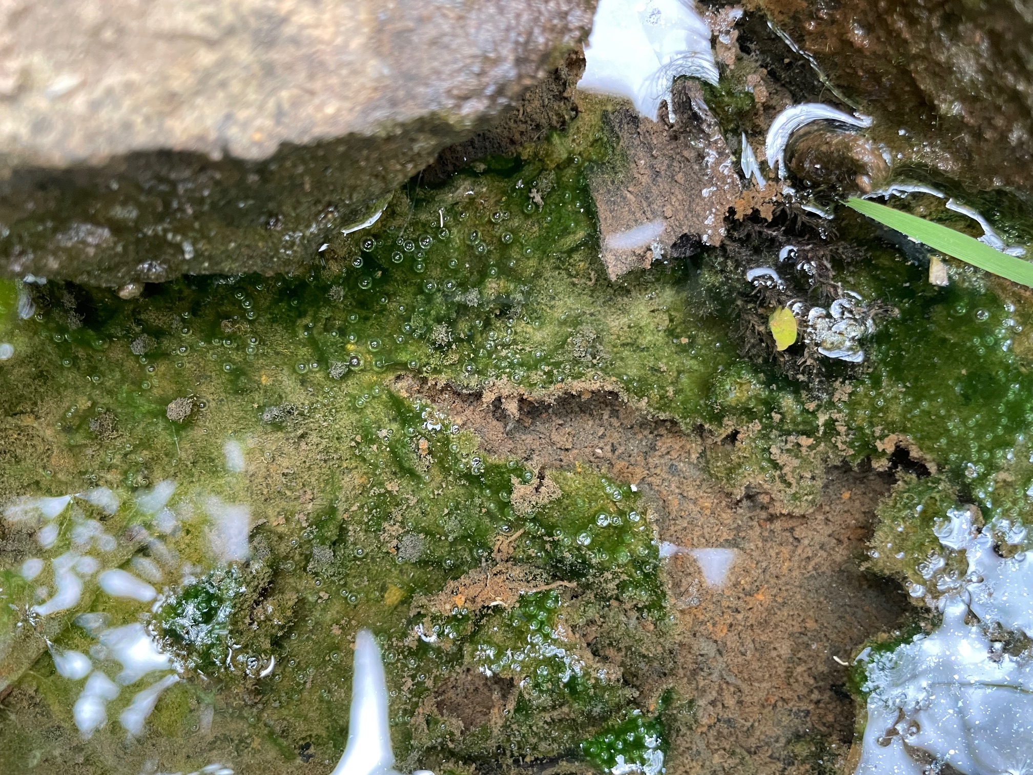
The veterinarian told them that Jax had likely ingested a toxic, algae-like microorganism called cyanobacteria, or blue-green algae, from a benthic bloom, a phenomenon scientists began documenting in the West about five years ago. Benthic blooms, which resemble globs of snot, form on stream bottoms or submerged logs or rocks, sometimes breaking free and rising to the surface. They are less familiar to Westerners than planktonic blooms, which form on the surface of lakes and reservoirs and look more like floating grass clippings or spilled green paint.
The cyanobacteria that cause planktonic and benthic blooms have existed in Earth’s waters for billions of years. Excess nitrogen and phosphorus from agricultural fertilizers or air pollution can cause them to proliferate. Research suggests that climate change is also contributing to more frequent and widespread blooms as warmer water stagnates during hot, dry years like this one, said Hannah Bonner, a professor and water scientist at Brigham Young University who studies benthic cyanobacteria.
It’s a cruel twist: As the West warms, once-inviting cool-water refuges may become a threat not just to pets, but to people and wildlife.
Cyanobacteria in both benthic and planktonic blooms can secrete toxic chemicals that irritate human skin, or, if consumed, cause nausea or even liver damage. The same toxins can kill any pets, livestock and wildlife that drink the contaminated water or lick their wet fur. No backpacking water–filtration systems can removecyanobacteria toxins.
Most Western states only began tracking planktonic blooms — which are easier to spot and monitor than benthic blooms — in response to health concerns in Eastern waters. In 2014, toxic cyanobacteria blooms in Lake Erie shut down Toledo, Ohio’s drinking water system. Wyoming began monitoring blooms in 2018, first with satellite imagery and then, starting in 2021, with on-the-ground water sampling. Utah ramped up monitoring in 2016. California and Oregon’s programs, which are among the oldest in the West, started about 20 years ago.
Benthic Cyanobacteria. Photo credit: USGS
Results from those and other programs suggest that planktonic blooms are popping up earlier in the season in more lakes and reservoirs and are lasting longer into the fall. Some experts believe the reported increases could be the result of more monitoring. But a nationwide Environmental Protection Agency study published in 2021 found that increased nutrients like nitrogen and phosphorus are combining with the warming and drying effects of climate change to create more and longer-lasting blooms.
“We’re affecting so much of the land surface and creating disturbances and introducing nutrients,” said Theodore Dreher, a microbiology professor emeritus at Oregon State University. Unlike climate change, where one continent’s emissions can affect the climate of another, nutrient pollution’s sources are often localized and can be more easily regulated. Utah, for example, has implemented regulations requiring improvements at places like wastewater treatment plants. It’s also created voluntary incentives for treating agricultural runoff and restoring floodplains. The combination has helped stem nutrient flow into Utah Lake, near Provo, where blooms were once so bad that people sold T-shirts with the slogan “Ski the Scum.”
In order to address the causes effectively, however, officials need to collect water quality data, not just monitor for blooms. Unfortunately, not enough are doing so, said Justin Hayes, Northern Rockies conservation director with American Rivers. “States need to take this really seriously and start trying to solve it rather than just warning people.”
Researchers are also still struggling to understand why recent blooms are turning up in unusual places. Planktonic blooms in high-elevation lakes far from septic systems and feedlots are becoming more common, possibly because of runoff from melting glaciers or atmospheric deposition of nitrogen and phosphorus from dust and air pollution, Bonner said. And benthic blooms may become more common as snowpack declines and produces less snowmelt. At the same time, parts of the West are seeing fewer monsoon rainstorms that can flush algal mats away.
“I was just in the mountains last weekend, in a pristine creek, and they were everywhere,” she said.
Bonner doesn’t think people should stay home to avoid blooms, but said they do need to know what to look for. A benthic bloom “is like a big ball of snot,” she said. “Find a stick, poke it, lift it up, and if you see hairlike strands or fibers, most of the time it’s not cyanobacteria or toxic. If it is a boogery consistency, it likely is.”
Meanwhile, more states are installing signs, sending email alerts, and posting public-health advisories that warn recreationists about toxic blooms.
And Bachman keeps talking to local and regional media, hoping Jax’s death will save someone else’s pet. “Everything upstream flows downstream,” Bachman said. “Just because you have a patch of it upstream doesn’t mean it won’t move down to you.”
Reporting for this story was supported by the Mighty Arrow Family Foundation.
There’s a growing shift toward locally generated power, sometimes called Distributed Energy Resources (DER) or Non-Wire Solutions, (NWS). While its far from replacing large privately-owned utilities, it represents one of the fastest-growing movements in energy policy and technology.
America’s power grids are not only expensive to build and to maintain, they’re also highly vulnerable to extreme weather events and even terrorism. One obvious solution is to generate power where its used instead of using a vast network of high-power transmission lines to convey power to where its needed.
1. Why Centralized Power is More Expensive
• Massive Infrastructure Overhead: Building and maintaining thousands of miles of high-voltage transmission lines, long-distance towers, and step-down substations requires hundreds of billions in capital expenditure—costs passed directly to ratepayer electric bills.
• Line Losses (Energy Wasted in Transit): Moving power over long distances dissipates 5% to 10% of total generated electricity as heat. Consumers pay for power that burns off before ever reaching their meters.
• Surging Interconnection Costs: Connecting a new massive utility-scale plant to the main regional grid often requires costly regional grid upgrades and takes 5 to 7 years in utility review queues.
2. Why Centralized Power is More Vulnerable
• Single Points of Failure: A single downed transmission line (from wildfires, storm winds, or physical attacks) or an issue at a regional substation can instantly sever power to hundreds of thousands of homes at once.
• Cascading Grid Outages: Interconnected long-distance grids are susceptible to wide-area blackouts when an unexpected surge or fault trips neighboring circuit breakers across entire state lines.
• Extreme Weather Exposure: High-voltage lines run through unpopulated, exposed terrain, making them far harder to monitor, protect, and quickly repair during major severe weather events.
3. How Local Power Resolves Those Issues
Locally generated power (such as rooftop solar, microgrids, and local battery storage), generates electricity close to where its needed. This obviates the need for long-distance transmission infrastructure, increases reliability, minimizes heat-loss waste, and allows local micro-grids to stay powered up even when the main regional grid goes down.
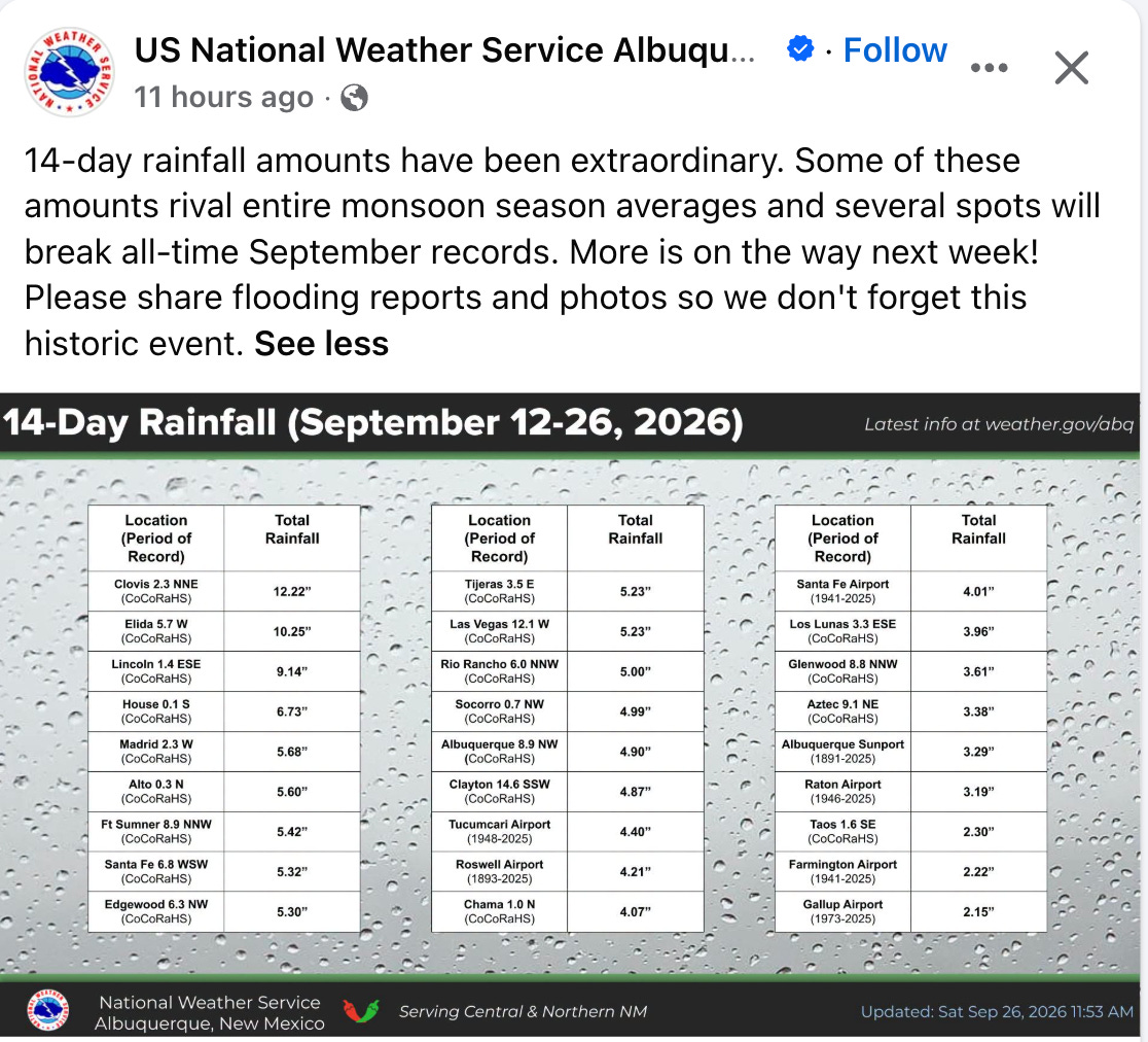
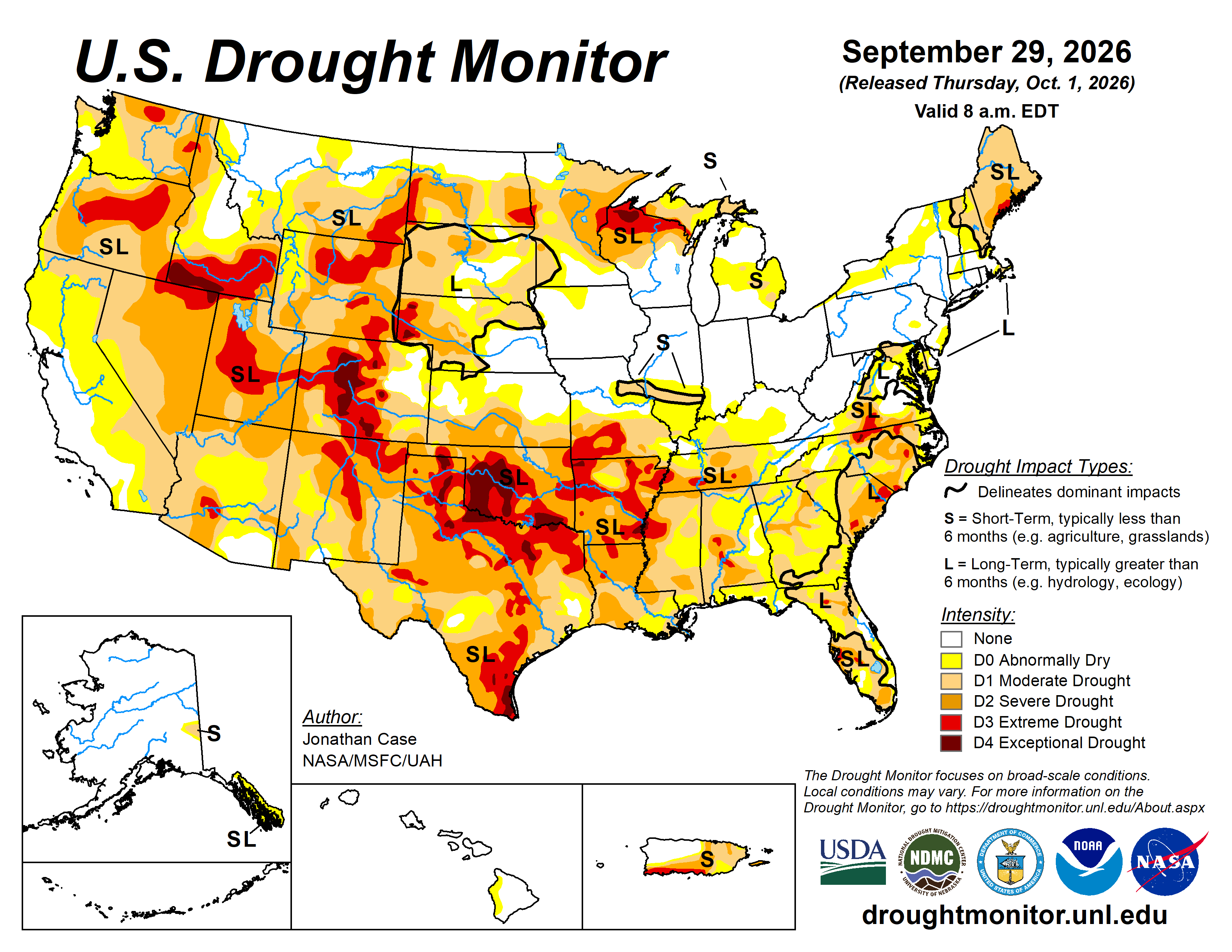
Welcome to another edition of the Land Desk’s NEWSWIRE, and yet another one in which the big news is the big, end-of-the-water-year rain. Yes, 88% of the Western U.S. is currently experiencing some level of drought — with the most severe impacts in the Four Corners Country. Yet these same areas have also been barraged with rain and inundated with flood watches and warnings for the last few weeks, and yet another big doozy is on its way.
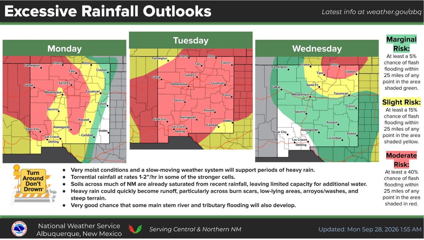
As of Monday morning (9/28), all of New Mexico, most of Arizona, and southern Utah and southern Colorado were all under a flood watch in effect through Wednesday morning. The National Weather Service is warning that rainfall rates in some places could be up to one to two inches per hour.
The latest round of storms will hit already sodden ground in places that have received more rain in the last couple of weeks than they normally do during the entire monsoon season.
🌵 PUBLIC LANDS 🌲
The Trump administration is reportedly considering Major League Baseball’s request to build a stadium and host a game in Grand Teton National Park, but a White House spokesperson says it is not an administration priority. (WyoFile) [Note: MLB has backed off this proposal since Jonathan published on the 28th.]
Western Watersheds Project and Basin and Range Watch formally protest the proposed 300-megawatt Bonanza solar-plus-storage project on 5,133 acres of public land in southern Nevada, saying it would fragment desert tortoise habitat and degrade vegetation and soils the tortoise depends on. (news release, BLM project page)
A Western journalist details the ways Interior Secretary Doug Burgum has disappointed conservationists and all Americans by “pulverizing environmental safeguards, leaving America’s public lands vulnerable for corporations to plunder at will.” (High Country News)
The Bureau of Land Management begins an aerial herbicide campaign on about 3,800 acres of public land in Sandoval and Cibola counties in New Mexico that will distribute Tebuthiron pellets in an effort to “enhance native plant diversity by reducing dense stands of sagebrush, juniper trees, and rabbitbrush.” (BLM news release)
The Bureau of Land Management greenlights the Indian Creek “watershed restoration” project that will include clearing piñon-juniper forest via chaining, mastication, and other methods on about 561,000 acres of public land in southwestern Utah. (news release)
The U.S. Forest Service seeks public input until Oct. 9 on its proposal to turn management of the Maroon Bells Scenic Area over to Pitkin County amid funding shortfalls. (news release, CBS News)
🌨️🦦🚣🏽 WATER WATCH 🌊
Washington County, Utah, plans to construct a wastewater treatment-recycling plant demonstration facility to help educate residents on water recycling and get them past the “ick factor” associated with “toilet-to-tap” facilities. (Salt Lake Tribune)
👩🏽🔬 SCIENCE! 🧫
University of California, Davis, researchers find orange water released by thawing permafrost into Alaska rivers can be more acidic and contain higher concentrations of metals than acid mine drainage. (news release)
⛏️ MINING MONITOR ⛏️
A federal study finds a major tailings spill at the proposed Donlin Gold mine in the Kuskokwim River watershed of southwest Alaska would inundate thousands of acres of land and portions of a village in the Crooked Creek drainage, alter stream channels, cause long-term harm to aquatic and terrestrial wildlife, and result in downstream heavy metal contamination that could last for over a century. (Mining, Draft Supplemental EIS)
Ivanhoe Electric relinquishes 642 unpatented mining claims covering 13,264 acres in the Gila National Forest in New Mexico where it planned to explore for copper following widespread local opposition. (news release)
Scene from the 2024 White Mesa rally and spiritual walk. Jonathan P. Thompson photo.
The White Mesa Concerned Community and Ute Mountain Ute Tribe will hold their annual rally and spiritual walk to protest the White Mesa uranium mill in southeastern Utah on Oct. 17 at 11 a.m. at the White Mesa Community Center. (Grand Canyon Trust)
🛢️ FOSSIL FUEL FOLLIES 📈
Screenshot from the Protect Navajo Air map.
Earthworks’ Protect Navajo Air campaign develops an interactive map showing oil and gas facilities’ proximity to schools and health care facilities and related air and water polluting incidents in the San Juan Basin in northwestern New Mexico. (Protect Navajo Air)
An energy economics firm urges the Rural Utah Infrastructure Coalition not to invest as much as $54 million in two proposed coal export terminals on the West Coast, saying they are too risky and may not open Utah coal to foreign markets. (Institute for Energy Economics and Financial Analysis)
🔥 WILDFIRE LOOKOUT 🔥
San Juan County, Utah, drops charges against a former resident and journalist accused of sparking the 2025 Deer Creek Fire near La Sal after flaws in the state’s investigation are revealed and amid questions about the county’s political motivations. (Salt Lake Tribune)
🤑 GENTRIFICATION JOURNAL 💰
An analysis of IRS data finds Teton County, Wyoming, was again the nation’s richest county in 2023 — with a per-capita income of $313,373 — followed distantly by Pitkin County, Colorado, and Blaine County, Idaho; yet even as residents became wealthier, they became less charitably inclined. (CoThrive)
🔋 THE GRID⚡️
The U.S. Energy Department awards Xcel Energy two $250 million grants for high-voltage transmission projects in southeastern Colorado designed to expand connections between the Western and Eastern power grids and bring wind power from the Great Plains to Colorado’s Front Range. (Big Pivots)
Weld County, Colorado’s commissioners vote to approve Enyo Energy’s 805-megawatt Chalk Bluff wind and solar-plus-storage project on mostly private land in the oil and gas-rich northeastern corner of the state. (Colorado Sun)
The Federal Energy Regulatory Commission pauses its licensing process for rPlus Hydro’s proposed pumped hydropower storage project at Seminoe Reservoir in Wyoming to allow the Bureau of Land Management to complete an environmental review of the contested project. (WyoFile)
Phoenix-area utility Salt River Project’s board votes to approve the proposed Marigold Energy Center in Stanfield, Arizona. The project will include 600 MW of solar, 400 MW of battery storage, and 675 MW of natural gas generation, along with a new substation and four miles of transmission lines, in an effort to meet growing demand and enhance grid reliability. (news release)
Nevada utility NV Energy becomes the ninth Western entity to join the California Independent System Operator’s extended day-ahead wholesale electricity market that will help integrate the balkanized Western grid. (Public Power)
OTHER NEWS
The National Congress of American Indians files an amicus brief in Tohono O’odham Nation v. Mullin challenging the Trump administration’s plan to build a border wall through the Tohono O’odham nation in southern Arizona, calling it an “unlawful infringement on tribal sovereignty.” (news release)
🥵 ARIDIFICATION WATCH 🐫
New Mexico farmers say this summer’s extreme heat stunted green chile crops’ growth, leading to a roasting-season shortage in many parts of the state, adding that a “Biblical” grasshopper infestation also curtailed yield. (KRQE)
🤖 DATA CENTER DIGEST 👾
Nevada-based Arevia Power proposes a “multi-building” data center on about 3,700 acres of federal public land near Boise, Idaho; the Bureau of Land Management says the agency is in the “pre-planning phase” and has released few details. (Idaho Statesman)
🐟 COLORADO RIVER CHRONICLE 💧
Colorado River watcher Ken Neubecker speculates about how a Lower Basin compact call might play out in Colorado. (Ken’s Substack)
📸 PARTING SHOT 🎞️
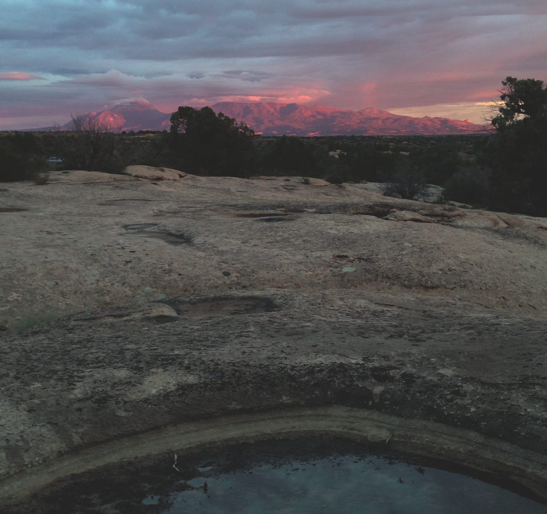
Ute Mountain after a storm. Jonathan P. Thompson photo.
DC Fast Chargers at Walmart. Photo credit: Allen Best/Big Pivots
Click the link to read the article on the Big Pivots website (Allen Best):
September 7, 2026
Colorado has nearly 500 fast-charging EV stations compared to 2,350 gas and diesel stations.
EV drivers will not find an EV fast charger on every street. However, state officials say Colorado is fast approaching the time where EV drivers can travel between the state’s four corners — not just along the Front Range and major interstates — and be confident of being relatively close to a fast-charging station. This, say state officials, represents a milestone.
“Public investment has helped make it possible to establish charging in locations that are essential to a truly statewide network but can be more difficult for the private market to serve on its own,” said Shoshana Lew, the executive director of the Colorado Department of Transportation, in a press release.
Gaps have been fast receding since 2020. Today, 83% of Colorado’s state highway network is within 30 miles of a DC fast-charging station, more than double the 40% six years ago.
Now, a new round of state funding is focused on providing drivers confidence they will be no more than 30 miles from a fast-charging station on federal highways.
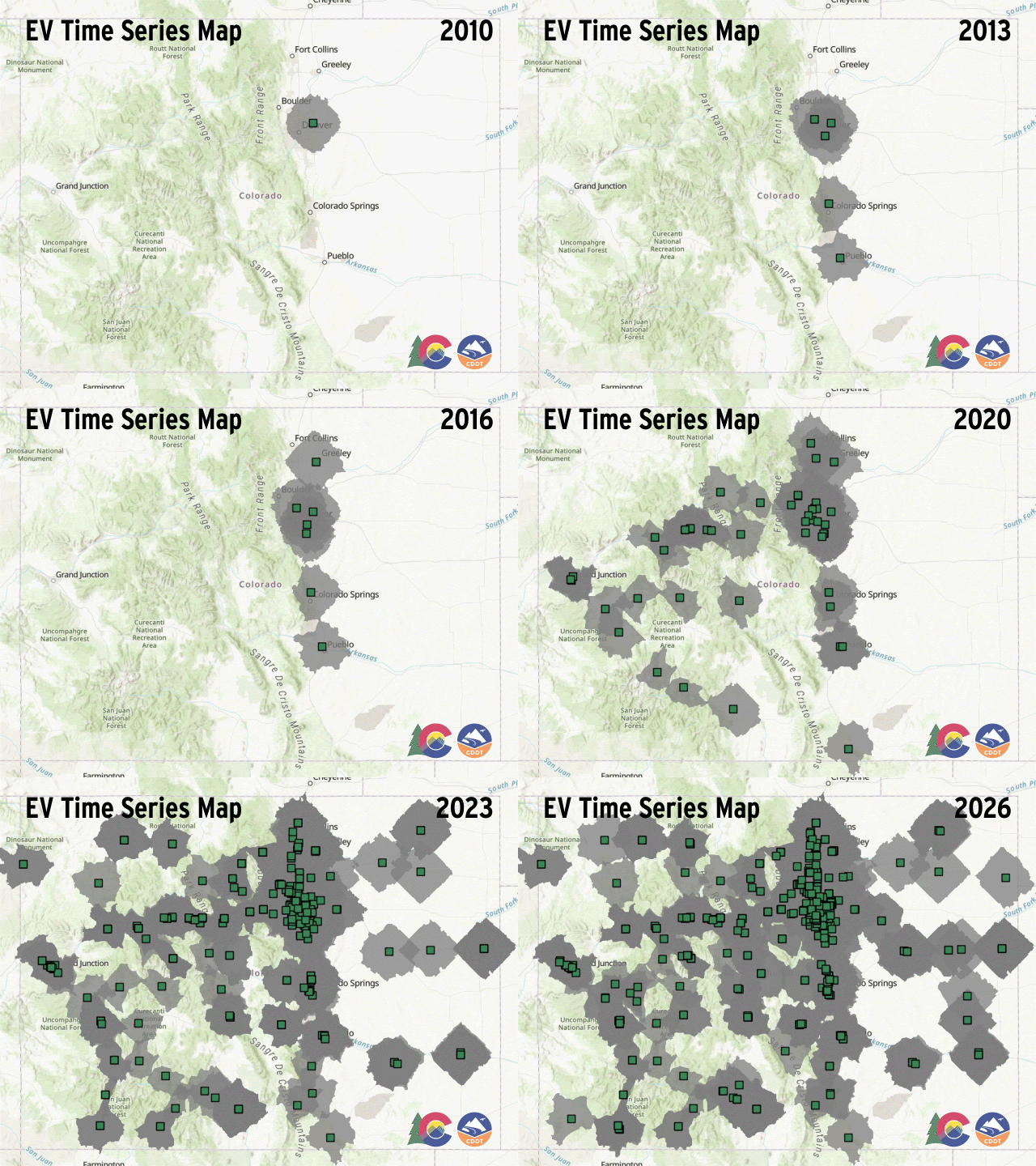
Animation of DC Fast Charger build-out in Colorado. Credit: CDOT Note: Tesla and Rivian DC Fast charging facilities are not on this map and they are available to other EV brands. One exception that I know of — the Cortez location is a joint Tesla/Colorado Energy Office operation.
Decline in sales
Ironically, the boom in sale of new EVs has slackened. New battery-electric vehicle registrations declined 55% this year through June compared to the same period in 2025, according to the Colorado Automobile Dealers Association’s 2026 second quarter report.
Colorado in the final months of 2024 led the nation in the percentage of sales adoption rate for EVs and plug-in hybrids. At one point, about a third of new car sales in Colorado were battery-electric, plug-in hybrids or hybrids. In 2025, sale of electric-only vehicles began slowing in favor of plug-in hybrids.
This most recent decline can be explained in part by the end of generous state and federal tax-based discounts to buyers. Tax credits of up to $6,000 offered by Colorado in 2025 dropped to $750 in January. The federal tax credit of $6,000 ended in September 2025.
Also relevant is that car sales altogether have slowed 15% in Colorado. This decline in EV sales is part of that broader decline.
Travis Madsen expects EV sales to recover.
“The investment Colorado is making recognizes that the future of road transportation will be electric,” said Madsen, the director of transportation programs for the Southwest Energy Efficiency Project, an environmental advocacy organization. “These investments are smart. Coloradans will save a ton of money, because it’s cheaper to drive an EV than an internal combustion engine vehicle.”
Madsen also expects improving incentives will be part of the discussion when Colorado legislators gather again in January for the 2027 session. Too, he suspects that a shift in the political makeup of Congress and perhaps the presidency in 2028 may result in restored federal tax incentives.
In addition, Madsen suspects the introduction of new models of bare-bones pickup trucks will spur sales. One new pickup, called Slate, comes in at $25,000 and will have a range of 205 miles. Ford’s Fathom will sell for a bit less than $30,000. Ford says the Fathom will have a range of 300 miles, but some auto writers seem skeptical. EV Charging Stations, for example, said an optional higher-capacity battery may be necessary to get this range.
Colorado currently has 217,000 registered EVS and plug-in hybrids among its 5.54 million cars, pickups and vans, according to the Alliance for Automotive Innovation. The state has a 2030 goal of 940,000 and a 2035 goal of 2.1 million.
A lot of federal help
Federal funding of $56.5 million administered through the National Electric Vehicle Infrastructure, or NEVI, program, has bolstered Colorado’s efforts to create its EV fast-charging network. So far, 17 of the fast-charging locations supported by the federal program have opened, but another 33 are under development.
Several of the EV fast-charging gaps on the lesser traveled highways of Colorado’s lightly populated eastern plains have been narrowed in the last year with the help of this federal program. For example, somebody driving southeast from Limon on Highway 287 toward Lamar or east on Highway 24 to Kansas would have had no way to charge an electric vehicle until fast-charging stations were added in 2025 at both Eads and Kit Carson. Wray also gained a station.
Walden, seen here during Christmas 2020, is in line to get an EV fast-charger. Photo/Allen Best
Another gap was filled in southwestern Colorado for drivers traveling the 80 miles from Durango to the Four Corners Monument. That station is at Cortez.
Other stations installed with help of the federal program are operating in Frisco, Longmont, Monument, Seibert, Grand Junction, Limon, Montrose, Maybell, Sterling, Durango, Lyons, Pagosa Springs and Walsenburg.
Now CDOT and the Colorado Energy Office are evaluating applications from the ninth round of the DCFC Plazas Grant Program. The state expects to have $14 million available. In this funding round, the state introduced a “gap incentive” of $174,000 per charging port aimed at attracting projects to high-priority communities and segments with persistent charging gaps:
State officials did not provide information about how much state money has been used to expand this fast-charging network. Also unclear is how the fast-charging stations installed by Tesla figure into this statewide matrix of fast-chargers. Nearly every major EV brand now has access to Tesla’s supercharging network.
Achieving scale
The goal all along in this effort to electrify transportation has been to achieve scale.
A website at the Colorado Department of Transportation shows the slow and then accelerating spread. First the stations were entirely along the Front Range. The first fast-charger in a rural area was installed in 2017, at a location in the San Luis Valley, followed by more along the interstate highways and then secondary highways. The expansion has been particularly rapid since 2020.
“Colorado has reached the point where we are no longer simply building the foundation of an EV fast-charging network — we are filling in the remaining gaps and making that network increasingly useful for travel throughout the state,” said CDOT’s Lew.
“Widespread EV adoption in Colorado would not be possible without convenient access to charging all across the state, from the Eastern Plains to the Western Slope and everything in between,” said Will Toor, executive director of the Colorado Energy Office.
Sifting through the numbers, though, the International Council on Clean Transportation in April released a report that paints a slightly less rosy picture of Colorado’s fast-charging infrastructure. “Meeting Colorado’s EV goals will require significant continued investment in charging infrastructure,” the council said.
The council said existing state and federal grants and utility investments, if made, could cover about 84% of non-home DC fast-charger needs through 2035.
And there is also this. Charging stations still take more time and are somewhat less assured, especially when traveling beyond Colorado’s borders. Consider the story of Florence resident Steve Andrews, an EV driver (Bolt) for many years.
In driving to Wisconsin this year, he will use an internal-combustion engine. Driving his Bolt, with its range of 250 to 300 miles, he says, would take close to a day longer. [Note: He could have rented a Tesla from Turo. This was the option I chose because my Leaf, like the Bolt, was not a road EV.]
Just how the charging infrastructure will evolve is anybody’s guess. It currently takes maybe 30 minutes to juice up a depleted battery, compared to 5 minutes to gas up a car or 10 or more minutes to fill the 36-gallon tank of a hulking pickup like a Ford 250 or 350.
In both cases the fast-chargers and the gas dispensers are located adjacent to shopping convenience stores. Operators make their money selling potato chips and soft drinks while also offering rest rooms.
Madsen said high-speed charging technology may evolve in uncertain ways. China already has very-fast-charging that can fill a depleted battery in 9 minutes, but that technology is not yet available in the United States.
“The way it works right now is you need to stop for 15 to 20 minutes, 30 minutes if you get a really big charge. It therefore makes sense to put these (charging stations) at places where drivers can spend time taking care of their other needs.”
U.S. 160 between Trinidad and Springfield in southeastern Colorado carries little traffic, even on a Fourth of July weekend. Photo/AllenBest
Highways with few travelers
Colorado — luckily — still has places where you need to think ahead no matter what kind of car you are driving. Consider U.S. 160, which connects Trinidad and Springfield, in the state’s southeastern quadrant. The landscape is delightfully sparse. You can drive 20 minutes or more, even on a holiday weekend, without encountering another vehicle. It’s you and the cows and likely pronghorn, too.
That 122-mile stretch of highway currently has one place to buy gasoline or diesel. It has no place to charge your EV, whether slowly or fast. It’s not among the “gaps” identified in state transportation planning. Probably, it will stay that way for a while.
Coyote Gulch’s Ariya at the summit of Loveland Pass September 19, 2026.
Here’s the link to my last post from my first road trip in my excellent road EV. I charged at ChargePoint, Tesla, Tesla/Colorado Energy Office, Rivian, and Ionna chargers.
Abby Burk with Audubon Rockies leads a tour of a flagship stream restoration project on Dry Fork Creek in Western Colorado. The project, located on High Lonesome Ranch, is one of the first completed under SB 270. CREDIT: HEATHER SACKETT/ASPEN JOURNALISM
After the 2020 Pine Gulch Fire scorched 95,000 drought-stricken acres of High Lonesome Ranch in Garfield and Mesa Counties, the rainstorms that followed eroded hillsides and washed mud and rocks into the Dry Fork Creek valley bottom.
“It was a major impact to operations here,” said High Lonesome’s General Manager Travis Brooks. “The wildlife habitat obviously was erased, populations disappeared… The flooding, the debris flows, the devastation that comes after the fire is almost as bad as the fire itself and we’re still seeing the effects of that.”
Brooks has overseen work to repair the riparian corridor and control erosion; now the area is green and wildlife – including beavers – have returned to the watershed. The area’s recovery is due, in part, to a piece of 2023 legislation that cleared the way for minor stream restoration projects in Colorado. High Lonesome Ranch is the site of one of the first of these types of projects completed since the passage of Senate Bill 23-270.
In 2023, Colorado lawmakers recognized the need to restore the environmental health of the state’s waterways, especially after wildfires. The legislation allows minor stream restoration projects to take place without being subject to water rights administration, provided they meet certain criteria. But this is uncharted legal territory and early projects are highlighting old tensions between water rights holders and proponents of stream restoration.
The Dry Fork Creek project, which is wrapping up its third and final year of work on High Lonesome Ranch, was spearheaded by Audubon Rockies.
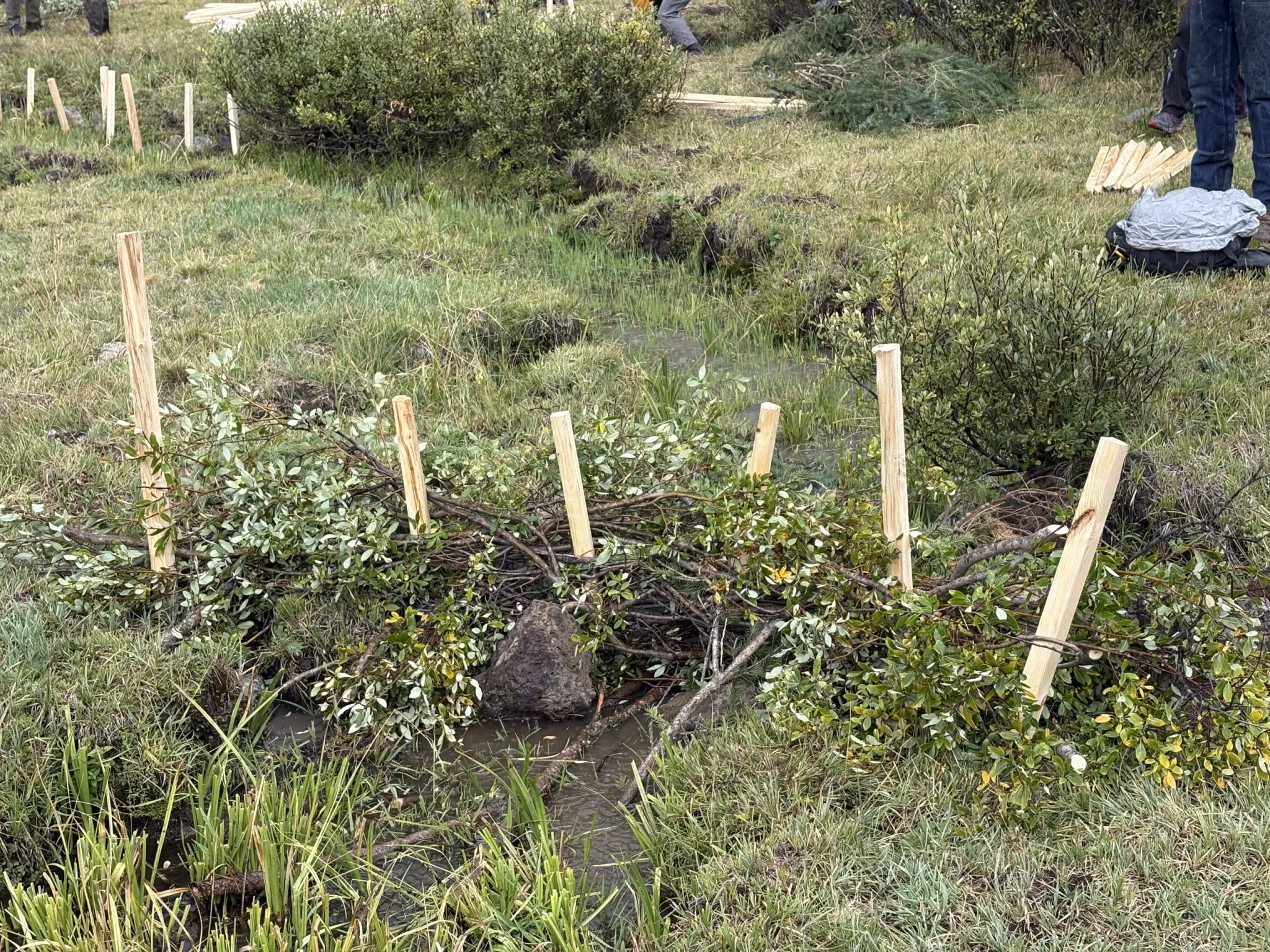
Over three years, crews installed about 200 simple, porous structures over two miles of stream, with the goal of trapping sediment, slowing the flow of water, raising the water table and rewetting the sponge of the floodplain. The structures, sometimes called Beaver Dam Analogues for the way they can mimic beaver activity, are built by weaving willows and tree branches across the channel between posts hammered into the streambed.
The official name for these low-tech, process-based restoration methods is Post-Assisted Log Structures, and they can turn a deeply incised, V-shaped stream with steep banks into a wider, gently sloping, U-shaped streambed. The structures act as speed bumps for the torrents that wash down the valley during summer storms and can improve watersheds that have been degraded by fire as well as human activities like road building and cattle grazing.
“I really do believe that we’re improving the water quality out here by doing this work, which is helpful to everybody downstream,” Brooks said. “I think that’s the biggest takeaway.”
On a sunny day in late September, Abby Burk, Western Rivers program director for Audubon, led a tour of the flagship project, showing how stream restoration is put into practice under the new legislation.
“All of these different types of structures are really looking at arresting sediment, holding sediment, spreading water on the landscape and slowing it down so that we can have a bit more of a connected floodplain,” Burk said.
Beavers have recolonized part of the Dry Fork Creek valley after restoration work. The burn scar from the 2020 Pine Gulch Fire is visible on the hillside. CREDIT: HEATHER SACKETT/ASPEN JOURNALISM
Putting policy into practice
Senate Bill 23-270 allows for six categories of minor stream restoration activities, such as stabilizing the banks or reconstructing a channel of a natural stream system. If a project falls under one of the six categories, it is presumed to not harm other water users and can move forward with little scrutiny from state officials.
Environmental groups that worked on the legislation had originally wanted to set a size standard for stream restoration based on the historical footprint of the floodplain before it was degraded. But opponents, some of whom were agricultural water users, argued this area was too large and ill-defined, and floated the idea of placing a cap on how much new surface area of water that projects were allowed to create. Their concern was that projects could create more surface area for evaporation and reduce streamflows.
That’s a problem because in Colorado’s system of water law where the oldest rights get first use of rivers, water is usually already spoken for by someone downstream. Without SB 270, stream restoration proponents could have to go through an expensive and lengthy process to buy into an augmentation plan, which replaces the water consumed by evaporation.
The final bill represented a compromise between the two sides, and required that these minor restoration projects don’t back up water past the “ordinary high-water mark” of the stream.
“I think this is an elegant compromise,” said Burk, who helped shape the bill. “We landed at a bipartisan solution that was unanimously supported.”
Immediately after the passage of the bill, stream restoration proponents were disappointed in the final version. But in the three years since, SB 270 seems to be providing the necessary legal and political cover for groups to move forward with low-tech, process-based projects, with several underway on the Western Slope.
“We started taking more time to process it and read it, and then we actually realized, you know, I think we actually got something pretty good here that we’re going to be able to do some great stuff with,” said Jackie Corday, a natural resources consultant who worked on the bill and the Dry Fork Creek project.
Clay Ramey with the U.S. Forest Service works on a stream restoration project with volunteers at the headwaters of Middle Thompson Creek in August. The project installed about 40 post-assisted log structures, designed to repair degraded streams. CREDIT: HEATHER SACKETT/ASPEN JOURNALISM
Downstream conflicts
As more groups take on projects under SB 270, it means the bounds of the legislation will be tested as potential conflicts arise with downstream water users.
On a Saturday in late August, the National Forest Foundation and Roaring Fork Outdoor Volunteers kicked off another restoration project, installing about 40 PALS in the White River National Forest in the headwaters of Middle Thompson Creek, a tributary of the Crystal River. The area was identified as a prime spot for stream restoration in a beaver inventory conducted in 2023 and 2024 by the U.S. Forest Service and funded by Pitkin County.
“Ideally, the changes in the channel that these [structures] provoke, and the changes in the vegetation will be enough to make those areas attractive to beaver again and beaver will just recolonize the site,” said Clay Ramey, a fisheries biologist with the White River National Forest.
The Forest Service is planning another, similar project next year in the headwaters of Four Mile Creek, one drainage over from Thompson Creek. But the size and scope of the proposed project has raised concerns from a local water conservancy district. The Rifle-based West Divide Water Conservancy District owns several small reservoirs and provides supplemental irrigation water and augmentation water for domestic water users.
West Divide says the project could impact water supply for its planned expansion of Martin Reservoirs. It contends the work would increase both the surface area of the stream, which causes evaporation, and the water consumed by wetland vegetation.
In a January letter to the state Division of Water Resources Division 5 Engineer Tyler Benton, the conservancy district said that the 152 structures planned over three phases is outside the scope of what is allowed by SB 270 and asks state officials to assess the project’s potential for injuring water rights holders.
“It’s not the healthiest stream by any stretch and so some restoration efforts are in order,” said West Divide board member Chris Treese. “But we don’t want those efforts to result in an impact to our water rights or any other water rights downstream that are within the West Divide district.”
This post-assisted log structure was installed on the headwaters of Middle Thompson Creek in August. The stream restoration project aims to rewet the sponge of the degraded watershed. CREDIT: HEATHER SACKETT/ASPEN JOURNALISM
More data needed
Part of the source of the disagreement comes from a lack of data about how exactly these types of projects that mimic beaver activity influence how water moves through valley bottoms.
Joel Sholtes, a water resources engineer and instructor at Colorado Mesa University, is aiming to answer that question. In August he was awarded a three-year $15,000 grant from Pitkin County Healthy Rivers to study how beaver activity alters ecosystems in the North Thompson Creek area. The sites with beavers can be a reference point to compare with areas restored by humans.
Sholtes will take seasonal measurements to try to better understand how much water beaver ponds detain, how it changes throughout the year and the differences in stream conditions between areas with resident beavers and those without. Sholtes’ early findings on a long-term study of headwaters across the state show that restoration projects do not produce large or sustained reductions in streamflow.
“The evolution and passing of SB 270 became contentious, and that conversation brought to bear a lot of knowledge gaps that we have related to stream restoration in headwaters,” Sholtes said. “There’s just not a big, robust body of literature, so the study’s number one effort is to address that in whatever ways we can. It’s not going to answer the question definitively, but it’s going to bring more data and nuance to the conversation.”
The Forest Service is monitoring and measuring the streamflows at the Four Mile project site to see what they are dealing with and the effects of their work – information West Divide is also interested in – with the intention of installing the first structures next summer.
For now, Burk says SB 270 is a good tool to accomplish 75% to 80% of the stream restoration projects that happen in Colorado. Most of these fall under three of the legislation’s six categories: stabilizing the streambanks with natural materials that allow water to flow downstream and don’t back up water past the ordinary high-water mark; stabilizing an intermittent stream by installing porous structures into the banks; and installing structures or reconstructing a stream channel for recovery from a wildfire or flood.
“This was designed for a subset of projects that are the majority to go forward because of the ecological and community benefits and watershed benefits,” Burk said.
A working group led by Burk and Corday has also created a training manual for best practices that groups can use to make sure their projects stay within the bounds of SB 270.
Abby Burk with Audubon Rockies stands in front of a post-assisted log structure, part of a restoration project on Dry Fork Creek. The project is one of the first completed under new state legislation that allows for minor stream restoration activities. CREDIT: HEATHER SACKETT/ASPEN JOURNALISM
Communication with DWR essential
So what happens when restoration proponents believe their project fits within these parameters, but downstream water users argue the project goes too far?
Division of Water Resources officials have a limited role in refereeing these types of disagreements. Project proponents are not required to get approval from state officials and state officials do not have the authority to approve or deny projects. But as the administrator of the state’s water rights, DWR officials could still force a project to be removed if they determine it is harming downstream water users or require the project to get an augmentation plan from a water court that replaces the water it uses.
In the case of the Four Mile project, Division 5 Engineer Tyler Benton wrote in a February letterto Ramey that he does not have sufficient information to determine if the project would harm downstream water users, but that the Forest Service should communicate with the local DWR water commissioner to ensure the project complies with the law.
Both Burk and Ramey stressed the importance of communication and transparency with DWR officials to ensure the projects are in compliance with SB 270 from the beginning. Ramey said the water commissioner has visited both the Middle Thompson and Four Mile sites and is familiar with the projects.
Back at High Lonesome Ranch, beavers have moved back into the restored area and created ponds, amplifying the humans’ restoration work. Brooks said the project fits with the ranch’s philosophy of conservation and regenerative ranching, and he has aspirations of doing more work to revitalize the property’s other fire-damaged drainages in the future.
“The beaver activity that we saw is a big indication that we’re doing something right,” Brooks said. “Wildlife are coming back and utilizing the space the way a healthy riparian system should be utilized.”
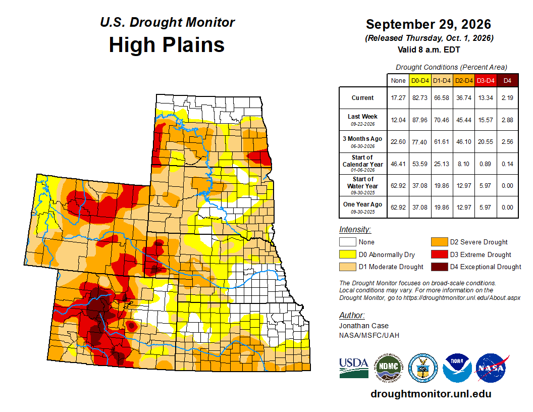
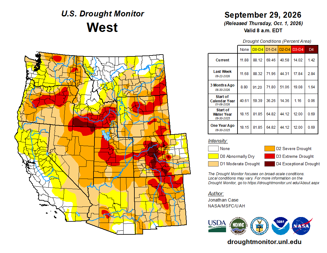
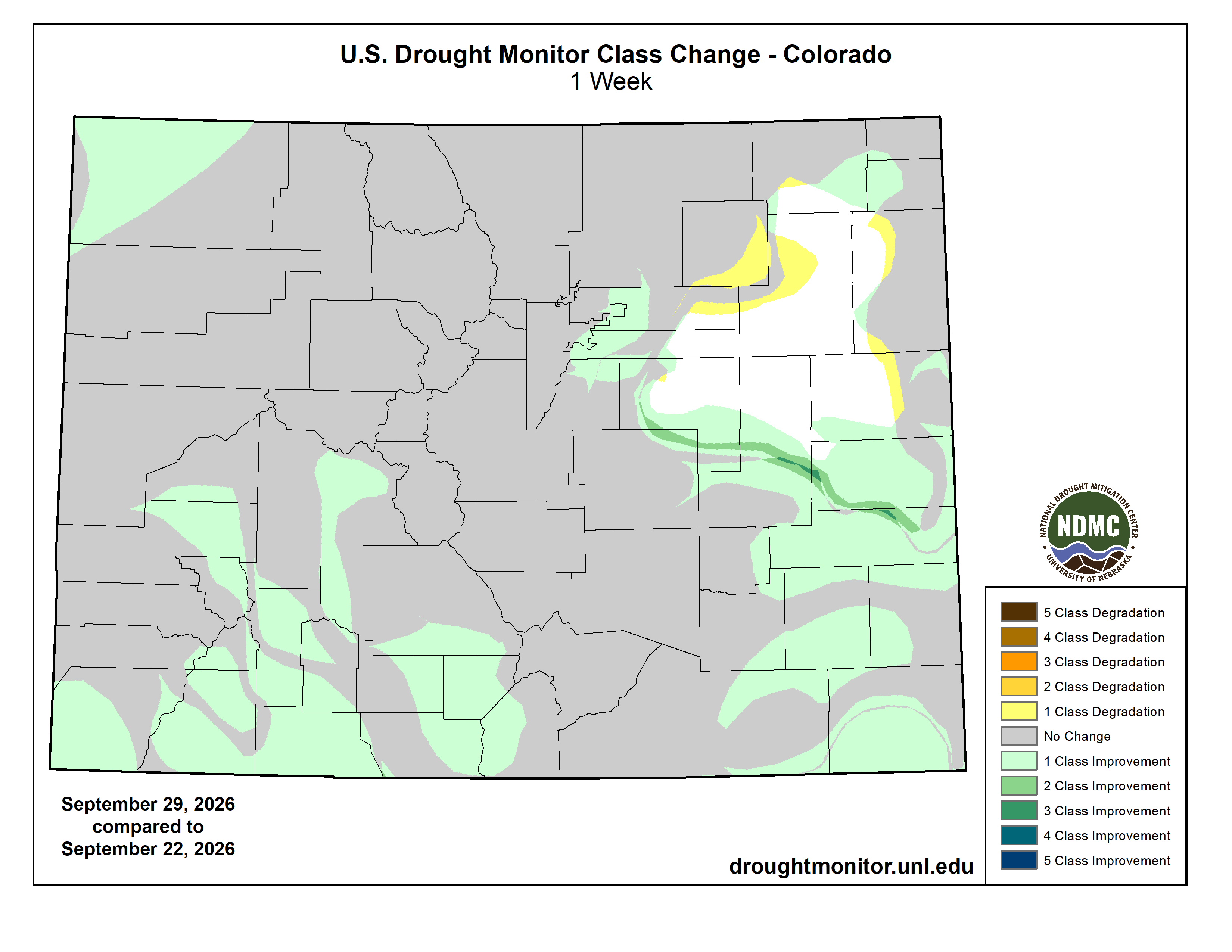
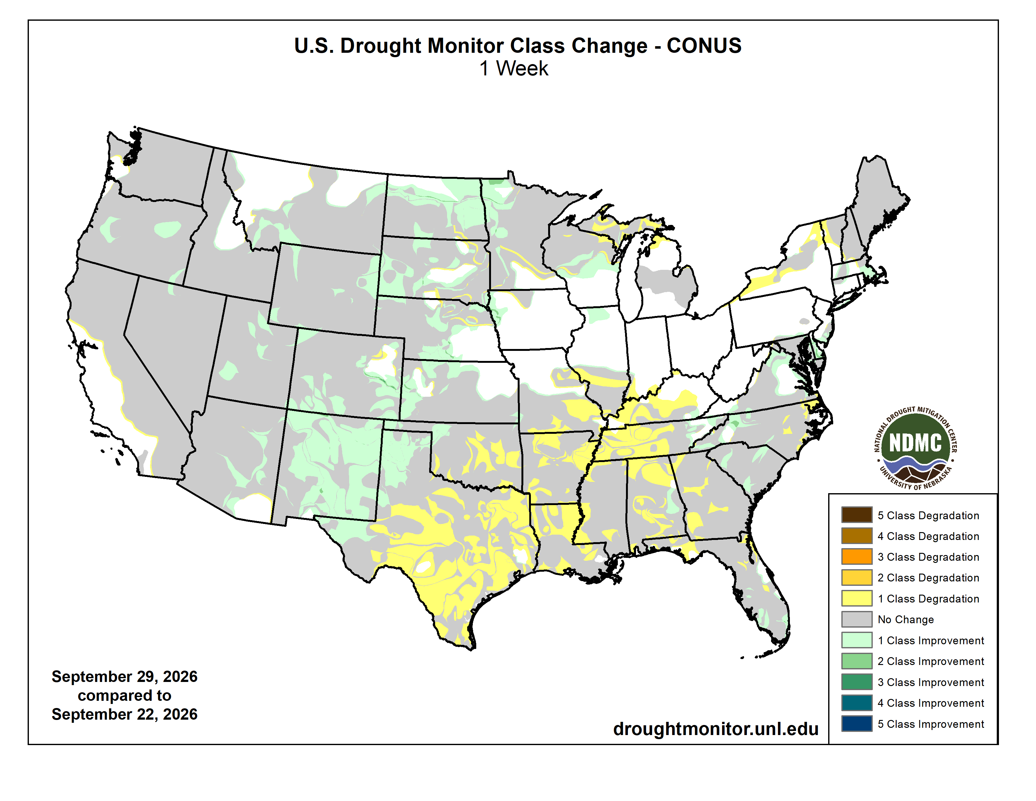
This week featured a dynamic and changeable drought environment across the country, partially thanks to the rapidly intensifying El Niño resulting in much above-average temperatures in the eastern Pacific waters. These warm ocean temperatures have been fueling numerous hurricanes in the East Pacific; three of which indirectly impacted the Unites States. Hurricane Nolo affected parts of the Hawaiian Islands with heavy rains, although mainly impinged on the east-facing slopes that are not in any drought or unusually dry conditions. Meanwhile, moisture from Hurricanes Odalys and Polo both contributed to a near-record moist environment over the normally dry Desert Southwest. Very heavy rains fell on much of New Mexico, and parts of Arizona, Utah, and Colorado both early in the period and again on Monday and Tuesday when Hurricane Polo curved northeast into the Baja of California and tracked into southern New Mexico. Weekly rainfall totals were very impressive across the Southwest, with totals reaching 5-10 inches, accounting for a large portion of the annual rainfall in some places. The heaviest rains fell across eastern New Mexico into northwestern Texas, helping to alleviate drought conditions. Beneficial rains also extended into southern and eastern Colorado into western Kansas and Nebraska, leading to drought relaxation. Coastal New England and the Mid-Atlantic states experienced a substantial Nor’easter that produced heavy rain, gusty winds, and storm-surge flooding from Delaware and New Jersey up to New York’s Long Island and southeastern Massachusetts.
The south-central and southeast states were not so fortunate this past week, however. Continued unseasonably hot dry conditions prevailed across the rest of Texas and Oklahoma eastward into the Tennessee River Valley, leading to worsening drought conditions in many states. The combination of persistently hot weather with virtually no rainfall during much of August and September has led to rapid onset drought in much of Texas and Oklahoma, resulting in widespread severe, extreme, and exceptional drought coverage, which again intensified this past week. Intensifying dryness and drought also prevailed across Arkansas, Louisiana, Mississippi, Alabama, Tennessee, and Georgia. And for those residing up north, the upper peninsula of Michigan and northern Wisconsin continues to suffer with worsening drought as precipitation was again meager there this past week. Outside of the Southwestern states, the remainder of the western U.S. had fairly steady-state drought conditions this past week, with only a few improvements occurring in the northern Rockies and in Oregon…
The High Plains states experienced almost exclusively drought improvements this week, as many areas experienced beneficial rainfall, with Colorado, Kansas, and Nebraska being beneficiaries of the east-Pacific “El Niño” tropical connection. Despite temperatures being up to 6 or more degrees above average, the plentiful rainfall has contributed to drought improvement in many areas this week. Northern and eastern North Dakota also experienced substantial reduction in drought coverage and intensity as heavy rain fell near the Canadian border…
Colorado Drought Monitor one week change map ending September 29, 2026.
Outside of Arizona, New Mexico, and Colorado, which experienced deep and substantial drought-busting rainfall this past week, the western states generally had unchanging drought conditions. The Pacific Northwestern states of Washington and Oregon began experiencing the first of its fall rainy systems, helping to ease drought pressure across western Oregon, where drought was downgraded in a couple spots. Drought and dryness also improved in southwest Montana and northwest Wyoming this past week…
The southern states have taken the brunt of recent drought intensification since August, which continued this past week across most of Oklahoma and Texas. Worsening drought also occurred across most of Arkansas, Louisiana, Mississippi, and Tennessee. Virtually no rain fell this past week in this region except for far western Texas, the Oklahoma Panhandle, and eastern Tennessee. Combined with temperatures of 6-12 degrees above average, the lack of rainfall contributed to the rapid intensifying drought. Most of central and eastern Texas, Oklahoma, and Arkansas are under severe, extreme, or exceptional drought classifications. Louisiana, Mississippi, and Tennessee are quickly degrading as well into severe to extreme drought conditions due to the September heat wave and continued lack of rainfall. Much of Texas and Oklahoma need to receive 20 to 25 inches of rainfall over a 3-month span to break out of the present drought. The lone exceptions to the drought worsening were in far western Texas and the western Oklahoma Panhandle, where several inches of rain fell as eastern Pacific tropical moisture associated with Hurricanes Odalys and Polo moved across the region. Far eastern Tennessee experienced temperatures around 3 degrees below normal along with the plentiful rainfall resulting in no drought conditions…
Looking Ahead
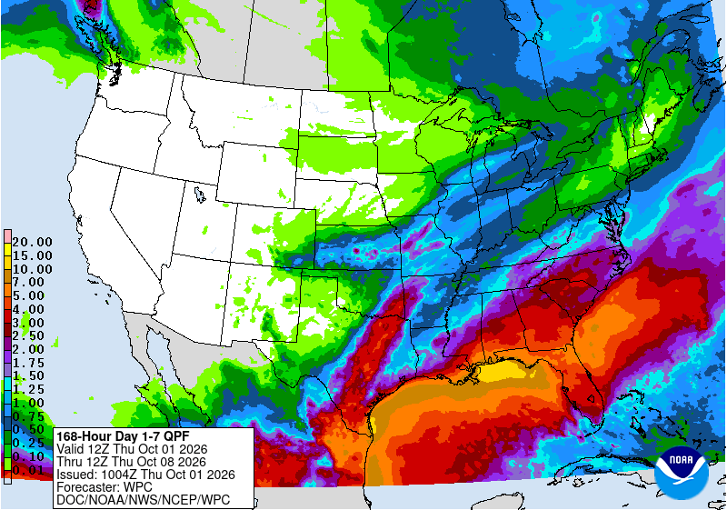
Ongoing substantial rain was falling Tuesday morning at the onset of the new U.S. Drought Monitor week, from Arizona and New Mexico into the Central and High Plains. This excessive rainy system connected to Hurricane Polo is projected to continue eastward this week into the High Plains, Midwest, and South regions. The Weather Prediction Center has moderate threats for excessive rainfall from the Southwest into Texas, Oklahoma, northward into Nebraska and Iowa. Drought-busting rains may be possible across the South as this weather system evolves this week. Looking into the next week, the Climate Prediction Center’s 6–10-day outlook indicates that well-above average temperatures will shift into the western states, along with below normal precipitation chances. Meanwhile, above average precipitation chances are projected from southern Texas into the southeastern states, including Florida. Above average precipitation chances are also projected for southeastern Alaska, with near neutral rainfall forecasts.
US Drought Monitor one week change map ending September 29, 2026.