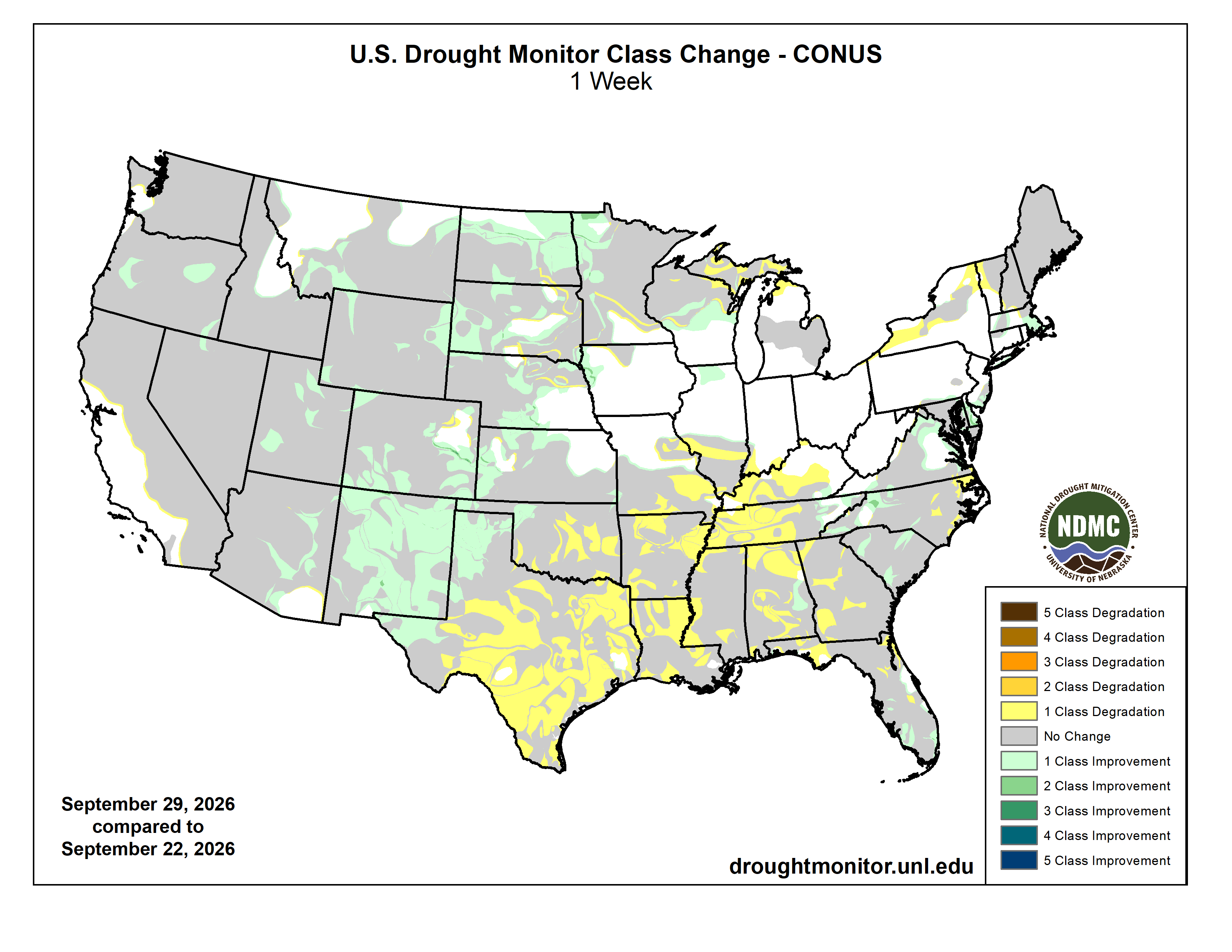
Click on a thumbnail graphic to view a gallery of drought data from the US Drought Monitor website:
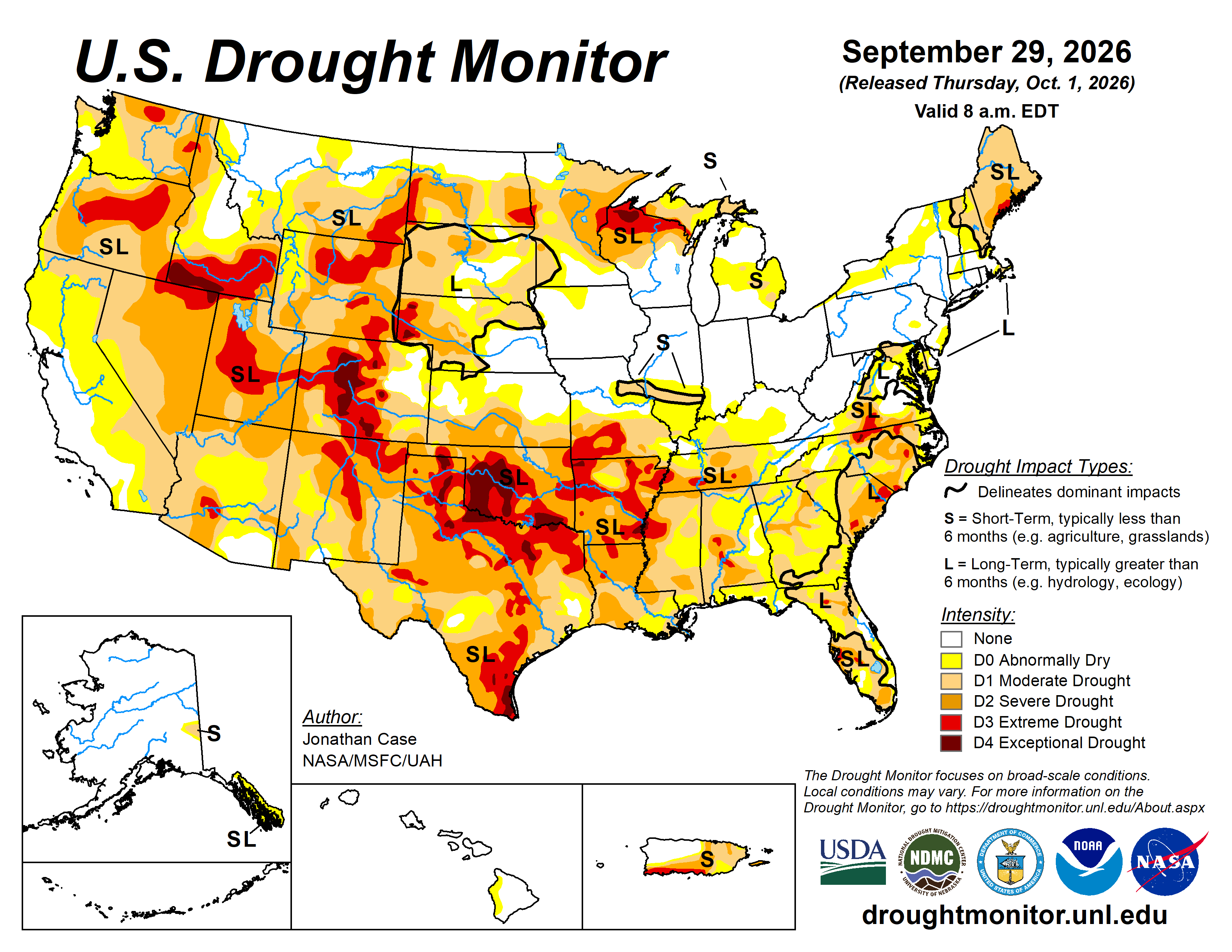

Click the link to go to the US Drought Monitor website. Here’s an excerpt:
This Week’s Drought Summary
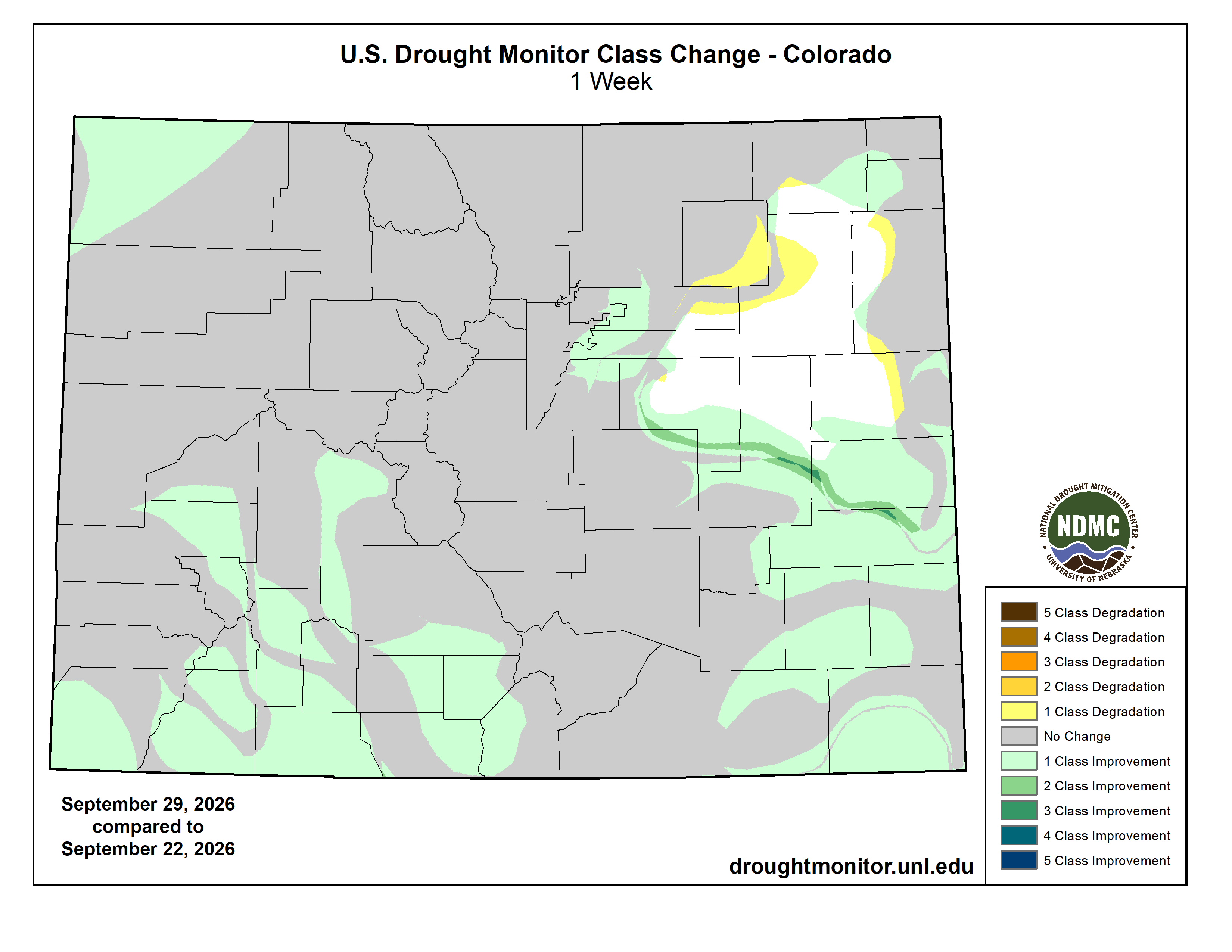
This week featured a dynamic and changeable drought environment across the country, partially thanks to the rapidly intensifying El Niño resulting in much above-average temperatures in the eastern Pacific waters. These warm ocean temperatures have been fueling numerous hurricanes in the East Pacific; three of which indirectly impacted the Unites States. Hurricane Nolo affected parts of the Hawaiian Islands with heavy rains, although mainly impinged on the east-facing slopes that are not in any drought or unusually dry conditions. Meanwhile, moisture from Hurricanes Odalys and Polo both contributed to a near-record moist environment over the normally dry Desert Southwest. Very heavy rains fell on much of New Mexico, and parts of Arizona, Utah, and Colorado both early in the period and again on Monday and Tuesday when Hurricane Polo curved northeast into the Baja of California and tracked into southern New Mexico. Weekly rainfall totals were very impressive across the Southwest, with totals reaching 5-10 inches, accounting for a large portion of the annual rainfall in some places. The heaviest rains fell across eastern New Mexico into northwestern Texas, helping to alleviate drought conditions. Beneficial rains also extended into southern and eastern Colorado into western Kansas and Nebraska, leading to drought relaxation. Coastal New England and the Mid-Atlantic states experienced a substantial Nor’easter that produced heavy rain, gusty winds, and storm-surge flooding from Delaware and New Jersey up to New York’s Long Island and southeastern Massachusetts.
The south-central and southeast states were not so fortunate this past week, however. Continued unseasonably hot dry conditions prevailed across the rest of Texas and Oklahoma eastward into the Tennessee River Valley, leading to worsening drought conditions in many states. The combination of persistently hot weather with virtually no rainfall during much of August and September has led to rapid onset drought in much of Texas and Oklahoma, resulting in widespread severe, extreme, and exceptional drought coverage, which again intensified this past week. Intensifying dryness and drought also prevailed across Arkansas, Louisiana, Mississippi, Alabama, Tennessee, and Georgia. And for those residing up north, the upper peninsula of Michigan and northern Wisconsin continues to suffer with worsening drought as precipitation was again meager there this past week. Outside of the Southwestern states, the remainder of the western U.S. had fairly steady-state drought conditions this past week, with only a few improvements occurring in the northern Rockies and in Oregon…
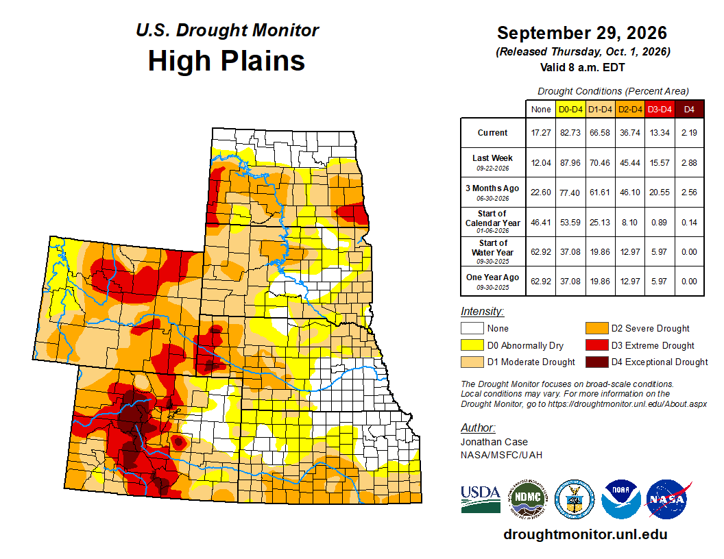
High Plains
The High Plains states experienced almost exclusively drought improvements this week, as many areas experienced beneficial rainfall, with Colorado, Kansas, and Nebraska being beneficiaries of the east-Pacific “El Niño” tropical connection. Despite temperatures being up to 6 or more degrees above average, the plentiful rainfall has contributed to drought improvement in many areas this week. Northern and eastern North Dakota also experienced substantial reduction in drought coverage and intensity as heavy rain fell near the Canadian border…
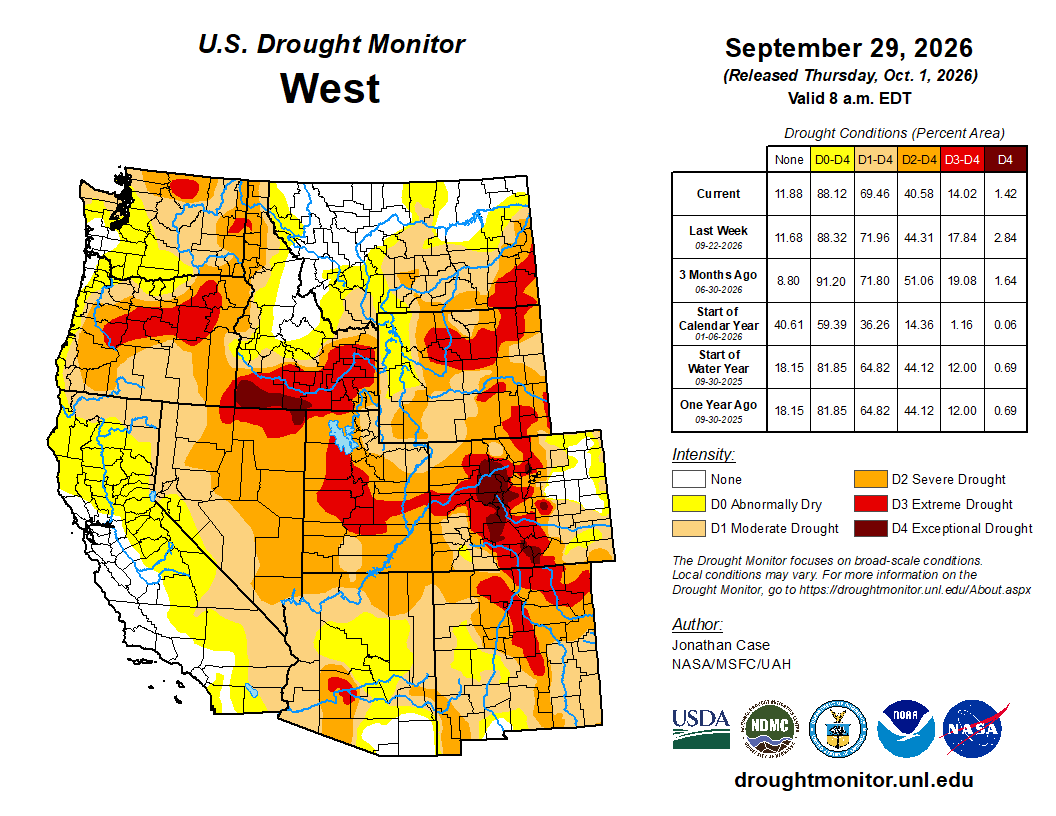
West
Outside of Arizona, New Mexico, and Colorado, which experienced deep and substantial drought-busting rainfall this past week, the western states generally had unchanging drought conditions. The Pacific Northwestern states of Washington and Oregon began experiencing the first of its fall rainy systems, helping to ease drought pressure across western Oregon, where drought was downgraded in a couple spots. Drought and dryness also improved in southwest Montana and northwest Wyoming this past week…
South
The southern states have taken the brunt of recent drought intensification since August, which continued this past week across most of Oklahoma and Texas. Worsening drought also occurred across most of Arkansas, Louisiana, Mississippi, and Tennessee. Virtually no rain fell this past week in this region except for far western Texas, the Oklahoma Panhandle, and eastern Tennessee. Combined with temperatures of 6-12 degrees above average, the lack of rainfall contributed to the rapid intensifying drought. Most of central and eastern Texas, Oklahoma, and Arkansas are under severe, extreme, or exceptional drought classifications. Louisiana, Mississippi, and Tennessee are quickly degrading as well into severe to extreme drought conditions due to the September heat wave and continued lack of rainfall. Much of Texas and Oklahoma need to receive 20 to 25 inches of rainfall over a 3-month span to break out of the present drought. The lone exceptions to the drought worsening were in far western Texas and the western Oklahoma Panhandle, where several inches of rain fell as eastern Pacific tropical moisture associated with Hurricanes Odalys and Polo moved across the region. Far eastern Tennessee experienced temperatures around 3 degrees below normal along with the plentiful rainfall resulting in no drought conditions…
Looking Ahead
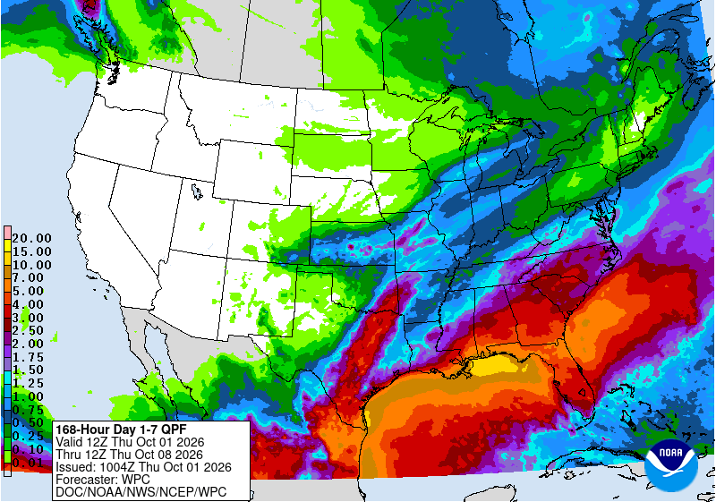
Ongoing substantial rain was falling Tuesday morning at the onset of the new U.S. Drought Monitor week, from Arizona and New Mexico into the Central and High Plains. This excessive rainy system connected to Hurricane Polo is projected to continue eastward this week into the High Plains, Midwest, and South regions. The Weather Prediction Center has moderate threats for excessive rainfall from the Southwest into Texas, Oklahoma, northward into Nebraska and Iowa. Drought-busting rains may be possible across the South as this weather system evolves this week. Looking into the next week, the Climate Prediction Center’s 6–10-day outlook indicates that well-above average temperatures will shift into the western states, along with below normal precipitation chances. Meanwhile, above average precipitation chances are projected from southern Texas into the southeastern states, including Florida. Above average precipitation chances are also projected for southeastern Alaska, with near neutral rainfall forecasts.