
Click the link to read the article on the Grist website:
November 9, 2026
A monster is growing in the Pacific — not the kraken, but something far scarier and deadlier. El Niño is a natural phenomenon in which a band of warm water forms every three to five years off the coast of South America. It raises ocean water temperatures by just a few extra degrees for typically nine to 12 months and ends up injecting an extraordinary amount of energy into the sky. It’s already the strongest El Niño on record, and it might not even peak for about another month or two.
“Those are actually really big changes for the ocean,” Art Miller, a climate scientist at the Scripps Institution of Oceanography, told Grist in September. “The ocean has a lot of heat content — 1,000 times more ability to hold heat than the atmosphere — so slight changes in the ocean surface temperatures can actually do a lot for the atmosphere.”
While scientists are still trying to figure out how climate change might be influencing El Niño, some research suggests that rising temperatures have led to stronger El Niño events. At the very least, we can use this event’s temporary warming to imagine what the climate will look like by default in two decades, as planetary temperatures continue to rise.
The effects of the current El Niño will be global, and they will be severe. Scientists have estimated that the additional heat alone could kill around 450,000 people worldwide. Drought is gripping some places, like the Amazon rainforest, while extreme rainfall hits others, like the Greater Horn of Africa. And the polar vortex — another phenomenon that periodically blasts the eastern and central United States with frigid air — interacts with El Niño in ways that can scramble weather even further. El Niño, then, won’t just fire heat into the atmosphere — it will fundamentally shift weather patterns the world over.
The atmospheric changes are so complex that different parts of the U.S. will endure vastly different impacts from El Niño. (There’s also a lot of uncertainty here: Models can predict general changes across regions, but no one can tell you what the weather will be in a given spot a month from now.) California, for example, typically sees increased rainfall and flooding. The Midwest might be relatively better off with a milder, drier winter, whereas the Southeast could get colder and wetter.
Which is all to say: Things are going to get very weird, and often very dangerous, across the U.S. To break it all down by region, Grist spoke to state climatologists and meteorologists. Here’s what they expect in the months ahead.
This winter’s outlook, region by region
The National Oceanic and Atmospheric Administration’s outlook for December through February predicts a warm North and a wet South. Darker shading means higher confidence in the forecast…

Alaska
Alaska is America’s largest state and home to all of its Arctic territory. That makes it uniquely vulnerable to the effects of climate change, which is warming the region several times faster than the rest of the planet. El Niño years add a blast of heat on top of that warming, intensifying local effects in the short term.
A strong El Niño, like the current one, tends to strengthen the Aleutian Low, a broad area of low pressure over the North Pacific that helps shape Alaska’s winter weather. But El Niño is only one of many factors influencing the Low’s strength and location. Depending on how these conditions line up in any given year, the state could experience vastly different outcomes. That makes the effects of El Niño especially difficult to predict in Alaska, said Martin Stuefer, the state climatologist and director of the Alaska Climate Research Center at the University of Alaska Fairbanks.
“We have to be on the lookout for more intense events, that’s for sure,” Stuefer said. “But we should be cautious about making conclusions based on what we know now.”
Evidence from previous El Niño events indicates that populated regions along the Gulf of Alaska and the state’s southeast might experience warmer winter temperatures, and precipitation may fall as rain instead of snow, Stuefer said. According to the National Weather Service, most strong El Niño years have resulted in below-average snowfall in Alaska.
Anything that intensifies warming in the state isn’t welcome news. Climate change is already melting away sea ice, leaving Alaska’s vast shorelines exposed to erosion during storms. It’s also thawing permafrost — the frozen ground found across much of Alaska — to collapse. Meanwhile, warmer waters are setting the stage for harmful algae blooms and changing the distribution of fish species that Native Alaskans have depended on for generations. A strong El Niño in the coming months could add to these pressures.
— Sachi Mulkey
Hawaiʻi and the Pacific Islands
Hawaiʻi and the Pacific have had a tough year already, and El Niño threatens to cause even more disruption. Low-pressure storms known as Kona lows and hurricanes have hit Hawaiʻi throughout the summer and fall, leading to severe flooding and power outages. Elsewhere in the region, super-typhoons like Sinlaku made landfall, causing 17 deaths in the western Pacific.
In the coming months, Pacific islands are broadly expected to face drier conditions and stronger storms. According to the National Oceanic and Atmospheric Administration, for example, Guam and the Commonwealth of the Northern Mariana Islands are facing an above-normal typhoon season, which will build on an already destructive summer and fall period. The threat is in addition to the rising probability of storms, fueled by warming ocean waters due to climate change.
“It only takes one storm to come over the island to cause crazy rainfall and devastation,” said Ryan Longman, who is the consortium program director at the University of Hawaiʻi at Mānoa for the Pacific Islands Climate Adaptation Science Center.
The Pacific islands are also bracing for a drier winter and spring. In Hawaiʻi, a strong El Niño can lead to a drier wet season, which typically lasts from October to March. That could mean less water available for residential, agricultural, and commercial uses and elevated wildfire risk.
The landscape is currently thick with grass and other vegetation from a historically wet summer. As the climate shifts toward drier conditions, those fuels on the landscape will dry up, increasing the chances of wildfires. Longman suggested that residents clear dry grasses and other fuels from their properties to reduce their risk.
For some Pacific islands, historic patterns suggest that the worst drought effects come the year following El Niño’s onset, meaning the most severe impacts could arrive in early to mid-2027.
— Joseph Lee
Midwest
The Midwest may catch a break when El Niño peaks this winter.
The cyclical climate pattern is mostly associated with milder, drier winters in the Midwest. El Niño shifts the polar jet stream — the band of fast-moving Arctic air high in the atmosphere — farther north, making it less likely that cold winds will dip into the region, resulting in warmer temperatures.
That doesn’t rule out snow and winter storms, though. It only means that average temperatures between December and February tend to be somewhat warmer. During recent strong El Niño events, winter temperatures ranged from 3 degrees Fahrenheit to more than 8 degrees F warmer than the 20th-century average, according to the U.S. Geological Survey.
The Midwest has already experienced a warmer fall this year, said Daria Kluver, a professor in the Department of Earth and Atmospheric Sciences at Central Michigan University. Average September temperatures across the region were the highest in the National Oceanic and Atmospheric Administration’s 132-year record. Illinois and Missouri had their warmest September on record; Wisconsin, Minnesota, Iowa, Indiana, and Michigan also saw above-average temperatures.
That warmth will continue into the winter. And reduced ice cover on the Great Lakes could contribute to the warmer temperatures, Kluver said. Without as much ice, warmth stored in the lakes over the summer is likely to slowly dissipate into the surrounding air. The changes in ice cover could impact Great Lakes economies, recreation, and the ecosystems that depend on it.
Fall has been dry so far, but winter might not be. Kluver said precipitation levels will depend on other dynamics like Arctic sea-ice levels and Atlantic Ocean currents. But the El Niño typically tilts the odds toward less snowfall and more rain or ice.
“Whether you find that good or bad maybe depends on what you do for winter recreation,” Kluver said.
El Niño could also mean a reprieve from the Midwest’s record-setting tornadoes next year, according to Chris Callahan, a climate scientist and assistant professor at Indiana University Bloomington.
“We are likely to have a relatively quiet tornado season in the spring, because those tornadoes are shifted south into [states] like Arkansas, Georgia, and so they might have a more active tornado season,” Callahan said.
— Vivian La and Juanpablo Ramirez-Franco
Northeast
The Northeast has so far avoided El Niño’s impacts — but that’s about to change.
Brad Pugh, a meteorologist with the National Weather Service’s extended prediction division, said the unusually strong El Niño this year gives the Northeast more than a 50 percent chance of a milder-than-normal winter. There could also be more precipitation, he added, though those odds will vary within the region.
While areas farther east are generally more likely to be wet, he said, “it’s hard to tell how much is going to be rain or snow.”Government outlooks don’t include snow totals because snow is difficult to predict far ahead. But the winter outlook from AccuWeather, a private forecasting company, projects fewer flakes for the Northeast. That, however, doesn’t mean the region won’t see snow, Pugh added.
“The forecast leaning on the wetter side does raise the prospects that there could be some high-impact winter storms,” he said, pointing to the I-95 corridor between New York and Boston as one area that could be hit. He suggested keeping an eye on the NWS’ eight- to 14-day forecasts to get a more accurate and timely sense of what weather may be on the way.
Even water that falls as rain could be concerning, said Auroop Ganguly, a hydrologist and co-director of Northeastern University’s Global Resilience Institute. “If I were an urban planner, I’d plan more for the possibility of flooding in urban areas,” he said. A mix of rain, snow, and ice on the roads could also make driving dangerous. “I’d prepare for somewhat more hazardous conditions on the roads.”
Still, many in the region may welcome El Niño’s arrival, especially after last winter, which was the coldest in a decade. Milder temperatures this year could, for example, lower heating needs at a time when heating oil and electricity prices are spiking.
As for the prospect of a warmer winter in the Northeast, said Ganguly, “Most people would say, ‘I’ll take it.’”
— Tik Root
Northern Great Plains
There is less certainty about the total El Niño impacts for the Northern Great Plains compared to the rest of the country. Nebraska, Montana, and the Dakotas are expecting a warmer-than-average winter, but rain and snowfall forecasts across these states are less conclusive.
In Nebraska, some of those effects may already be emerging. Earlier this fall, the eastern part of the state experienced milder temperatures and heavy rain, leading to flash flooding. Wetter-than-normal conditions are likely to continue in eastern Nebraska through winter, increasing the risk of additional floods, said Eric Hunt, a University of Nebraska-Lincoln agriculture meteorology and climate resilience extension educator. The state could still see intense winter storms, and western Nebraska could experience a wetter winter, though those forecasts are less certain.
Farther north in the Dakotas, the National Oceanic and Atmospheric Administration has forecasted a 40 percent to 60 percent chance of higher average temperatures from December to February. For North Dakota, that still means average temperatures below freezing. Winter also tends to be dry in both states, and forecasts for precipitation are variable, according to both states’ climatologists.
In South Dakota, a snowy winter could alleviate drought, replenish surface water, and reduce fire risk in the Black Hills, said state climatologist Laura Edwards. A dry winter in the state could be a tipping point for drought conditions next spring.
In North Dakota, it’s not clear if any precipitation this winter would improve drought conditions, said Daryl Ritchison, North Dakota state climatologist and director of the North Dakota Agricultural Weather Network. One winter storm could push seasonal totals above average for precipitation for the season, but if the winter remains dry and spring rains are slow to arrive, fire risk might increase.
Montana faces much of the same uncertainty. In the Northern Rockies, the odds favor a below-average snow year — but only slightly, said Kyle Bocinsky, the director of climate extension with the Montana Climate Office. Montana has experienced four strong El Niño events in the past 40 years; three saw below-normal precipitation and snowpack, but one saw above-normal snowpack. “It’s a small sample size,” Bocinsky said, which makes it hard to definitively say what the impacts will be. “It’s still a 50-50 chance,” he said.
Bocinsky said warmer temperatures could make for a rainy winter similar to last year, particularly at lower elevations. Like much of the Great Plains, eastern Montana is still in drought carried over from last year’s mild winter. Farmers and ranchers are hoping snow settles on the landscape this year, but it’s just too soon to tell, he said.
— Ellis Juhlin and Anila Yoganathan
Northwest
The Pacific Northwest typically sits in the center lane of a storm highway. Every winter, ocean storms travel across this familiar route, delivering a steady supply of the cool, drizzly weather that gives the region its gloomy charm. But El Niño is likely to reroute this storm track to the south, dumping rain onto sunny California instead. This often leaves the Northwest warmer, and sometimes drier, than usual.
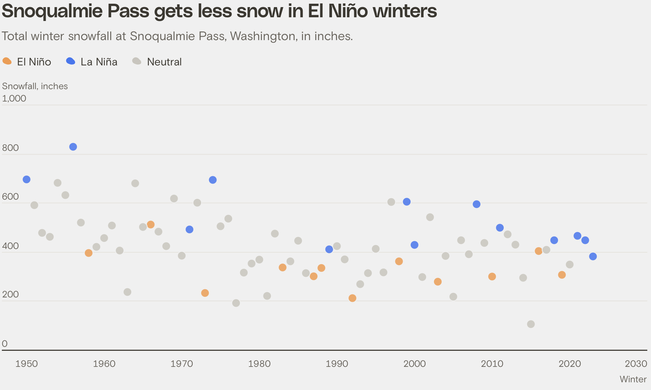
That combination could be a double whammy for mountain snow, which is the main source of water for much of the Northwest, since snow can’t form if it’s too warm or too dry. “If we were to get both of those this year — both the warmer temperatures and less precipitation — that could spell trouble for our snowpack,” said Jacob Genuise, an engagement climatologist at the Washington State Climate Office.
Climate change is also slowly chipping away at snow levels. Since the mid-20th century, snow levels in Washington’s Cascades have been steadily decreasing in both El Niño and La Niña years alike. These factors could lead to less snow stored in the mountains for next spring and summer, driving up the risk of drought or wildfires, and leaving less water available for irrigation, drinking water, or hydropower.
Nick Bond / Washington State Climate Office / Clayton Aldern / Grist
On the coast, El Niño can also lead to more tidal flooding. As ocean and wind patterns shift across the Pacific, seawater can get pushed toward the West Coast, raising high tide levels by several inches. This extra tidal boost could also combine with sea level rise, storm surges, or winter king tides to drive up the flood risk in Washington’s and Oregon’s coastal communities. “It’s not a huge effect,” said Genuise. “But that can mean the difference between a property getting flooded or not during these El Niño years.”
— Jesse Nichols
Southwest
El Niño often delivers rain and snow to the Southwest and could bring a glimmer of hope to a region suffering historic drought. Jon Meyer, assistant state climatologist at the Utah Climate Center, expects the weather pattern to bring “favorable storm activity” to the desert Southwest, including Arizona and New Mexico, with effects bleeding into Nevada and parts of southern Utah and southern Colorado.
But northern Utah, which is home to most of the state’s population, “is right in the bull’s-eye of being very unpredictable,” he said. Colorado’s outlook is also mixed. El Niño tends to bring more precipitation in spring and fall, but it also typically creates drier conditions for the Northern Rockies, said Peter Goble, assistant state climatologist at the Colorado Climate Center.
“The strong El Niño, as interesting a story as it’s been,” he said, “doesn’t guarantee us anything.”
The region is in dire need of snowpack in the winter months ahead. Utah’s Great Salt Lake hovers just a few inches above eclipsing the record-low elevation it set in 2022, and its vast exposed lake bed is drying into a dust source impacting the health of the roughly 2.5 million residents living in cities near its shores. Meanwhile, Lake Mead and Lake Powell, the nation’s largest reservoirs, saw a fraction of their normal inflows from the Colorado River and set their own record lows over the fall. Around 40 million people in the West depend on water supplies delivered by the Colorado River system.
The early autumn run-up to the super El Niño has already brought downpours, sending torrents through city streets and arroyos across the region. Arizona is already facing flash flooding and could now see tornadoes and other extreme weather, according to meteorologists at AccuWeather.
More moisture would boost desiccated reservoirs and reduce sleepless nights for farmers, but experts are already repeating an all-too-familiar warning: One good year won’t solve the region’s water woes. Western states saw record-breaking snow in 2023. Today, that moisture is gone, and both the Rio Grande and Colorado River basins look more stressed than ever. Climatologists say those extreme oscillations will become more common as climate change heats up the region.
— Austin Corona and Leia Larsen