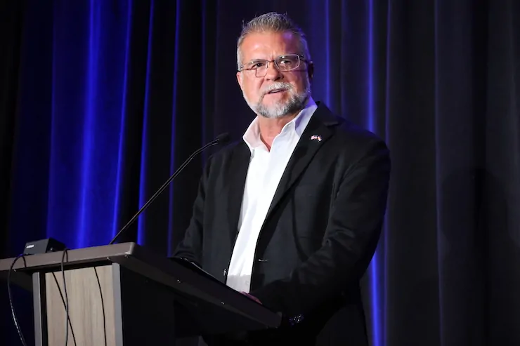
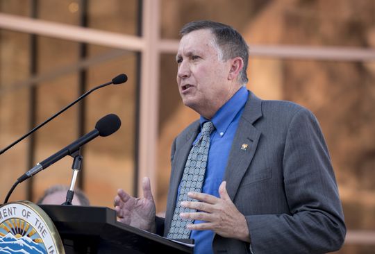
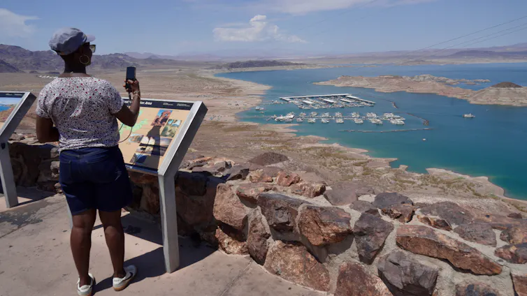
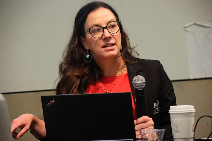
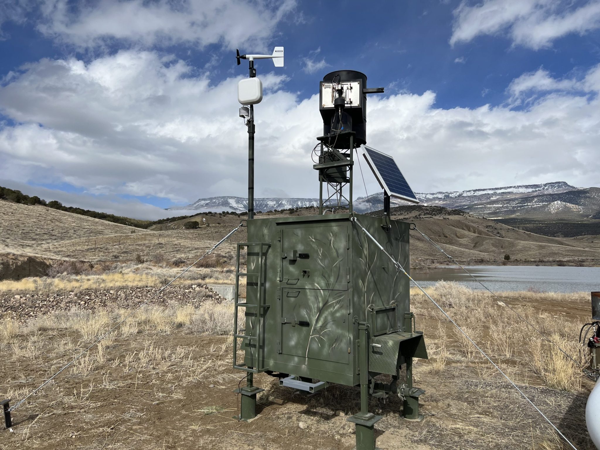
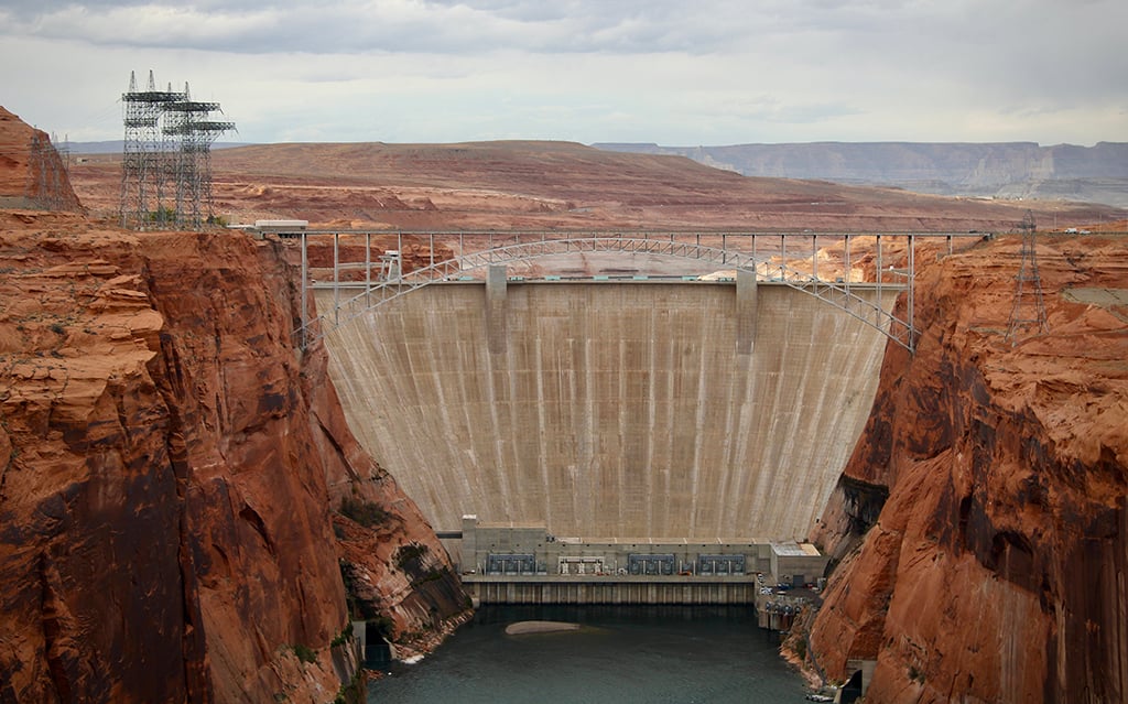
Lauren Boebert at the Colorado Water Congress Annual Summer Conference. Photo credit: Allen Best/Big Pivots
Click the link to read the article on the Big Pivots website (Allen Best):
August 31, 2026
Many political office-seekers spoke at the annual summer conference in Steamboat. Some ‘y’alled to the attendees. Others not so much. Most called for more water storage and “forest resilience.”
“God bless, y’all,” said Victor Marx, the Republican candidate for governor in Colorado in wrapping up his allotted 15 minutes at the podium at the Colorado Water Congress summer conference in Steamboat Springs.
Lauren Boebert, who represents the Fourth Congressional District in Colorado, followed him on the agenda. “It is wonderful to be back with y’all at Water Congress,” said Boebert, a Republican seeking her fourth term in Congress.
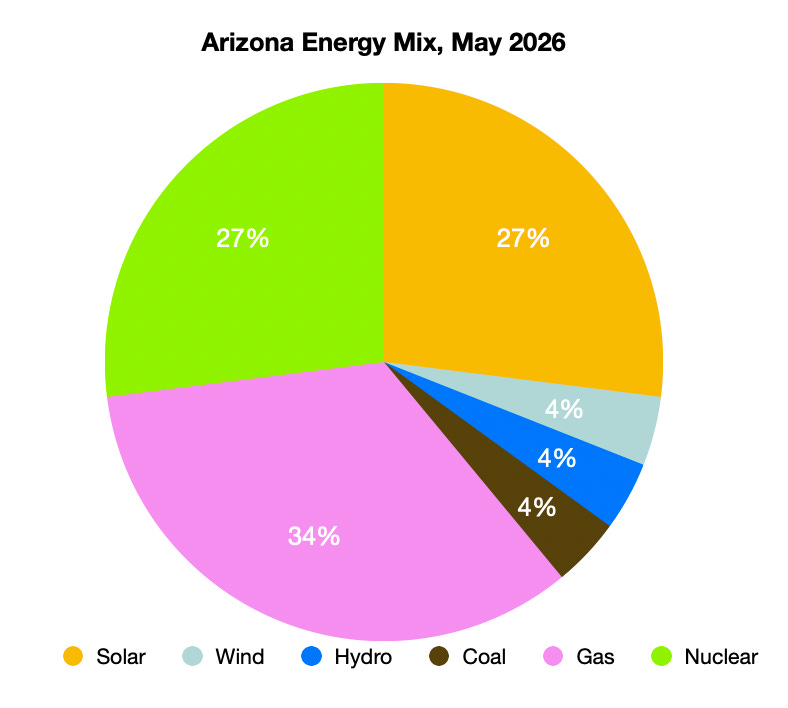
Y’alls were common during her quarter-hour on stage. It being a water conference, one of them had to do with water. “So y’all better get real good at that xero-scaping for your lawns and everything you’re building out there because your cactus, your cacti might do just fine, but we’re taking it back,” she said of Arizona.
Dwayne Romero, the Democratic candidate in Boebert’s former Third Congressional District, who preceded them, used none.
What this says exactly, I’m not sure. Y’all is a Southern locution that has become somewhat more common across the United States. I do note that Romero grew up in southeast Texas while Marx was reared in Louisiana, both of those places thick with y’alls and drawls. As for Boebert, she came to Colorado from Florida at the age of four.
Water Congress’s twice-annual conferences always have elected officials as well as water leaders from across Colorado. This being election season in 2026, the time devoted to the pols was greater than normal.
Victor Marx, the Republican nominee for Colorado governor, says Colorado must be prepared adequately for when the rain and snow returns. Photo/Allen Best
Like Marx, some are seeking statewide offices, while others, including Boebert and Romero, are running for Congress in districts with more rural areas.
That makes sense, as the Water Congress has a strong rural constituency. Denver Water is well represented, but so is Logan County. I also noted that Rod Lenz, the chair of the Republican River Water Conservation District’s board of directors, managed to get to the conference by Wednesday morning after a meeting in Holyoke that lasted long into the previous afternoon. That’s a good five-hour trip by car.
As for the y’alls, I have no idea whether Jeff Hurd, the Third Congressional District incumbent, Phil Weiser, the Democratic nominee for governor, drawled y’alls. I suspect not. I have heard both speak several times. Neither is a y’all guy. Both are also attorneys.
Perhaps not surprisingly, Romero and Boebert started out on much the same note in their remarks about the Colorado River. Romero mentioned “decades of lower-basin use” and urged solidarity with Colorado’s negotiating team on “protecting Colorado’s compact entitlements.” Boebert struck the same tone but with more pugilistic language. “We’re fighting for what belongs to us and for our future generations.”
Beyond those obligatory remarks, the two candidates differed greatly. Boebert talked about what she has done for her constituents regarding water and mentioned her work on the Arkansas Valley Conduit Project. “Even though my dear great president may have vetoed that, we are still working to get that over the line for Southeast Colorado.”
Boebert was typical Boebert, saucy and sort of interesting in how she played to her base. She wore blue jeans, as that seems to be her style when making the rounds in Colorado. In what may be more revealing, she also tried to talk about her bi-partisan work. I also noticed she did so when running in a tight race in her former congressional district, the third, in 2022. She won that race by a mere 546 votes, precipitating her move across the Continental Divide.
Maybe it’s because she is in what appears to be a tougher contest with the Democratic candidate, Eileen Laubacher, a retired Navy rear admiral, in a district that in the past has been unflinchingly Republican. Laubacher’s resume, money and growing institutional support could, noted Axios in a story last week, “make Boebert sweat.” Laubacher also spoke at the conference. But again, I was elsewhere.
Themes
Two themes were evident in remarks made by the office-seekers and others at the conference. One was the need for more storage, the other for more “watershed restoration” via Proposition 137, the proposal on the November ballot to divert sales tax revenues from sporting goods to do work in the forests and expand funding for parks.
The discussions in a general way crossed party lines but the storage case was cited more prominently by Republican speakers. Absent, though, was the sort of specifics I thirsted for.
Politicians rarely get into the details when on the stump, of course. And 15 minutes isn’t much time. Boebert’s comments will likely be echoed in the next two months.
“Forest management is not optional anymore. It never was, and for anyone to come up and present policy that is more reactive then proactive is failing you and each and every one of us — is failing future generations,” said Boebert. “Healthy forests hold snow longer, release water cleaner, and protect our watersheds from catastrophic fires that turn drinking water into ash.”
Boebert then took aim at clean energy.
“We hear all the environmental claims about carbon emissions, but these wildfires that are too quickly growing out of control, burning down our beautiful state, neighboring states in the West, with more than 6 billion standing dead trees that no one will allow us to harvest or not harvest enough of, unfortunately even taking lives of first responders…”
Boebert attributed to NASA a statistic: A wildfire produces more greenhouse gas emissions than all of the cars fueled by fossil fuels in a year.
“So EVs aren’t the answer. Sending your money to DC for wind and solar isn’t the answer. It’s being good stewards of our land, managing our forests.”
The storage theme also got lots of attention. It was bipartisan. Little of the conversation went very deep. Some of it was almost insultingly oversimplified.
Consider what Marx had to say: “We can’t make it snow. We can’t make it rain. But we can decide whether we’re prepared for when the water comes. So I believe we should store water in good years. Lord, please send it.”
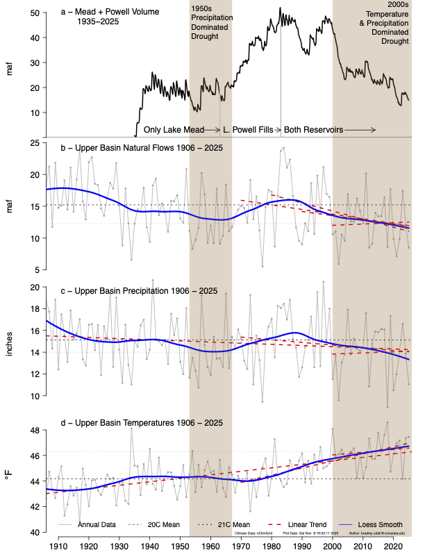
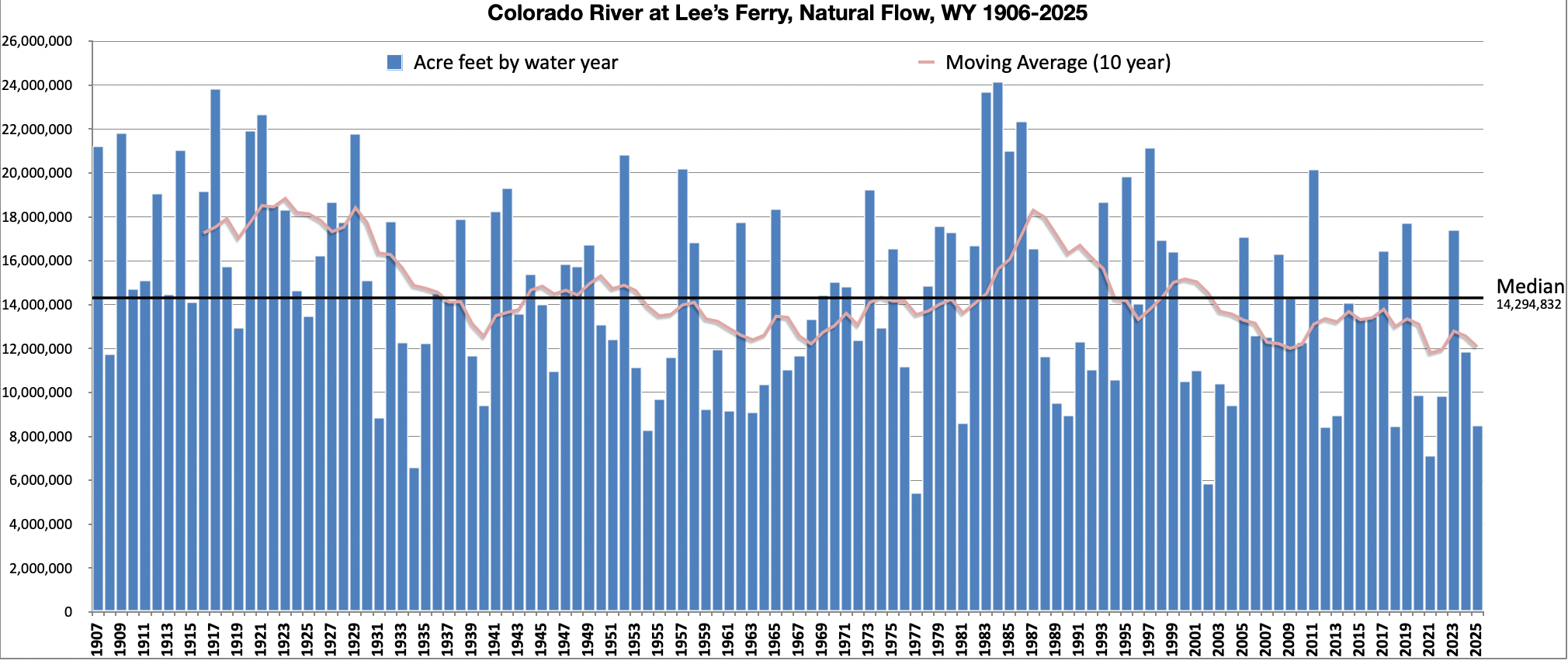
Udall/Overpeck 4-panel Figure Colorado River temperature/precipitation/natural flows with trend. Lake Mead and Lake Powell storage. Updated through Water Year 2025. Note the tiny points on the annual data so that you can flyspeck the individual years. Credit: Brad Udall
It sounds good, being “prepared adequately.” But that statement assumes good years will come. Examining the science, Colorado State University’s Brad Udall has suggested there may not be any good years, let alone enough to fill all the [reservoirs] already built.
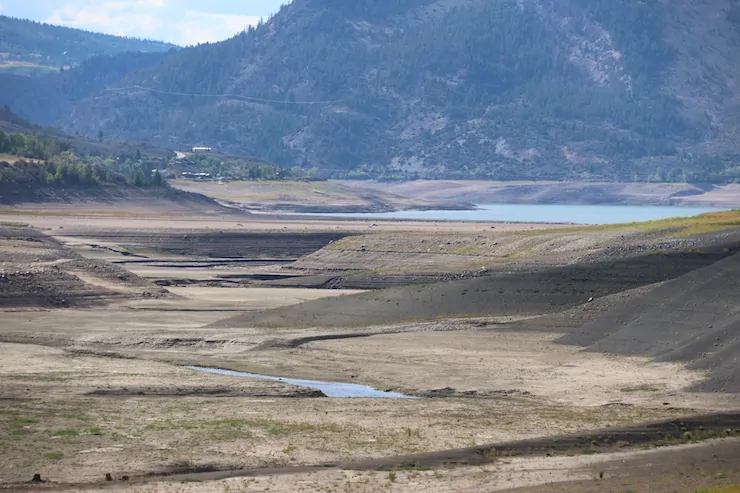
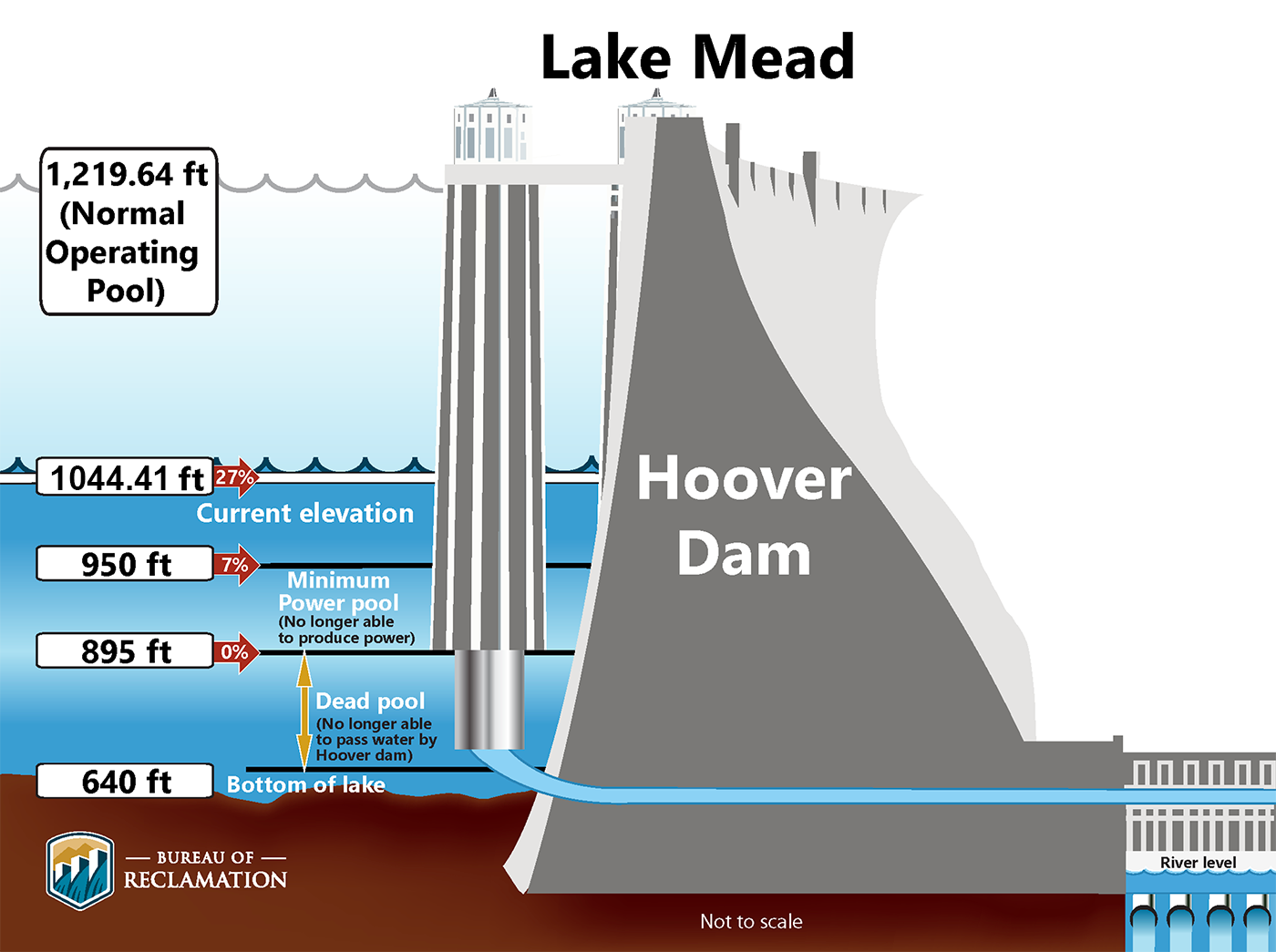
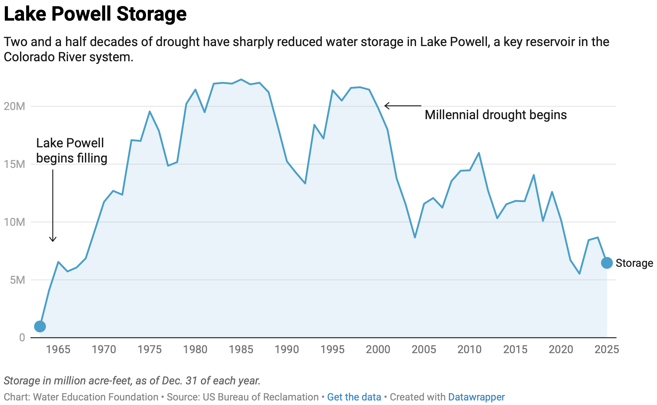
Consider that we have two giant reservoirs on the Colorado River sitting 75% empty. And in the headwaters, Green Mountain Reservoir is 15.1% full, as of Sunday, according to the Bureau of Reclamation. Blue Mesa Reservoir was only marginally better. Navajo, on the Colorado-New Mexico border, is doing better at 40% to 45%.
Romero’s call for partnership
Of the three office-seekers I heard, Romero was most interesting. It was obvious to me he had taken the time to study the Colorado River issues. As for Marx, he rambled.
Romero’s comments were calculated, of course. He was making a case for stability after the chaos of the Trump presidency.
“We have to restore Congress and our federal agencies as institutions that work. Congress has to legislate. It has to authorize projects. It has to appropriate money. It has to conduct oversight. Those are all the rules that were stipulated in the Constitution for our Congress,” he said.
I suspect Jeff Hurd would agree with at least parts of that statement.
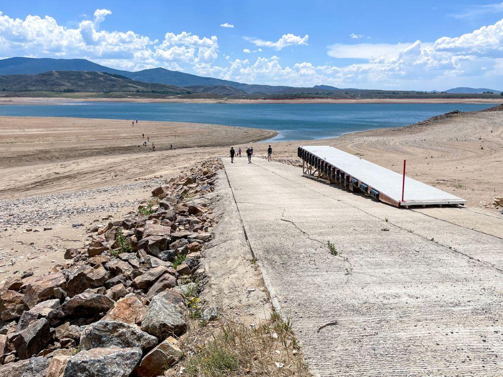
Green Mountain Reservoir, seen here on Aug.17, sits about 85% empty. Most other reservoirs have more water stored, but not that much. Photo/Allen Best
He later talked about what this meant on the ground. “A rancher can’t make long-term conservation investments around a pilot program that could disappear with the next administration,” he said.
What must be restored, he continued, is a federal partnership with the state, “where federal dollars turn local grit into lasting resilience. So here’s the heart of it: We have the right people, we have the expertise, we have the will. Now we need to bring real, sustained funding and solutions and resources to bear, enough to help us build resilience for the next 50 years of demand. And we need genuine, reliable partners.”
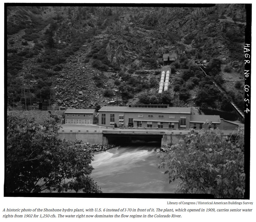
As for resilience, said Romero, it comes from many projects. “It’s a modernized diversion that lets a farmer grow more with less. It’s a storage that gives a community room to breathe in a drought. It’s a treated watershed that doesn’t burn catastrophically. And it’s securing an historic right like Shoshone, so it benefits Colorado permanently.”
Shoshone, of course, is the hydroelectric plant in Glenwood Canyon, and the Colorado River District is nearing success in its multi-year effort to make sure that the very senior water rights continue to ensure water flows downstream. It’s complicated, of course.
“These things take money. The federal government has helped build the water structure that made this modern American West possible. It is their responsibility to be a reliable partner with us, adapting that infrastructure and those institutions to the 21st century. They need to stay with us for capital and capital improvements.”
Romero wrapped up his speech with this observation: “Our hardest moments are often when we find our common ground.” That means, he said, “creating solutions that last beyond the next drought, the next negotiations, or the next administration, but for generations to come.”
Sounds good – but where does additional storage make sense that allows communities to breathe?
As for forest resilience, it sounds good — but what exactly is being proposed? Most environmental organizations seem to support Proposition 137, as do Denver Water and Northern Water. Western Resource Advocates and other environmental organizations are pushing it.
I still have major questions about the mechanics even after sitting through an hour-long press conference on Monday morning. Sometimes I can be fuzzy in my thinking, but in this case I think there’s some fuzziness about what is being proposed.
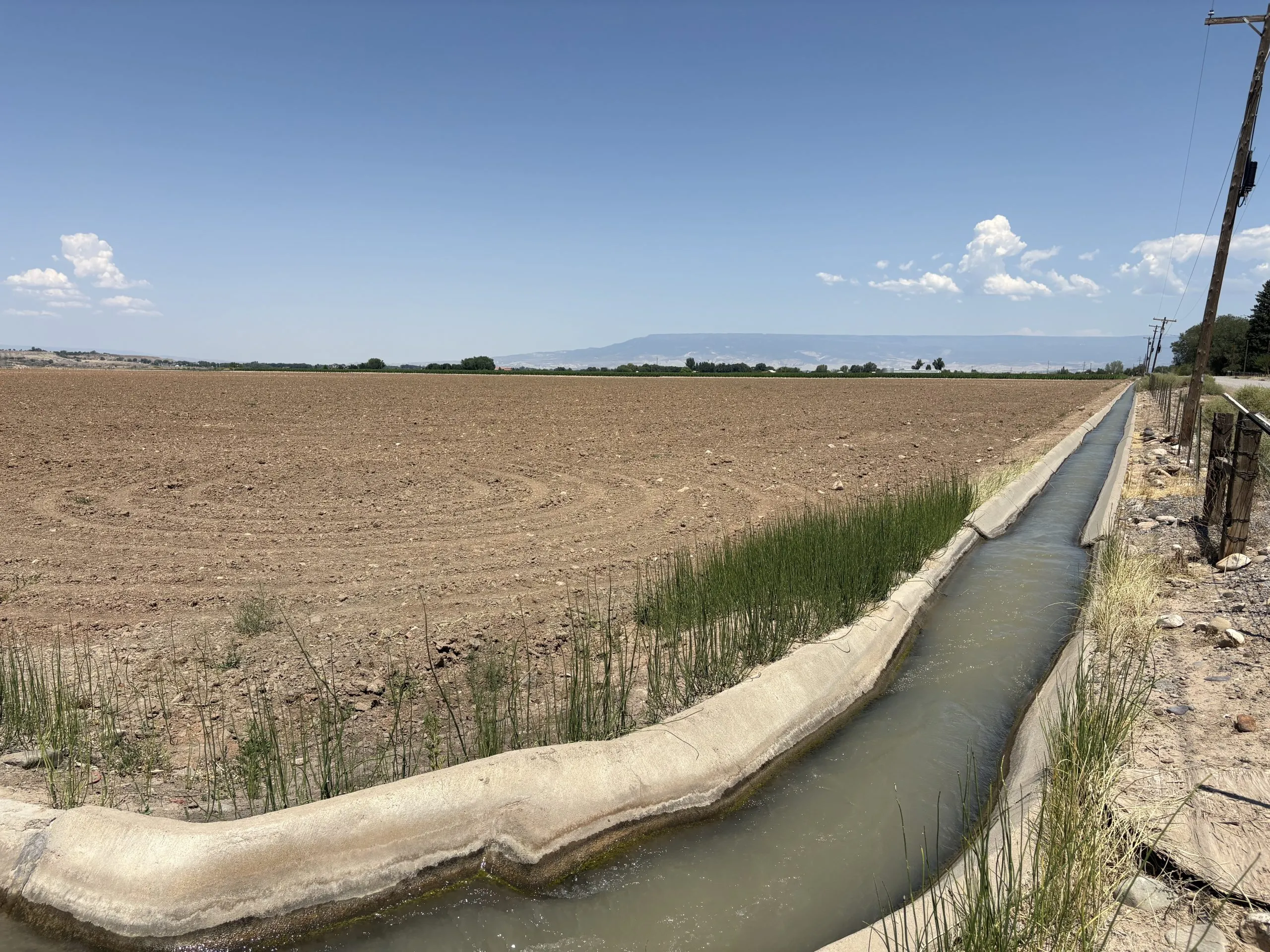
This ditch in the Uncompahgre Valley Water Users Association flows past an unplanted field. The River District is concerned that legal tools the state plans to use for its new conservation program could favor certain regions, like the Uncompahgre Valley. CREDIT: HEATHER SACKETT/ASPEN JOURNALISM
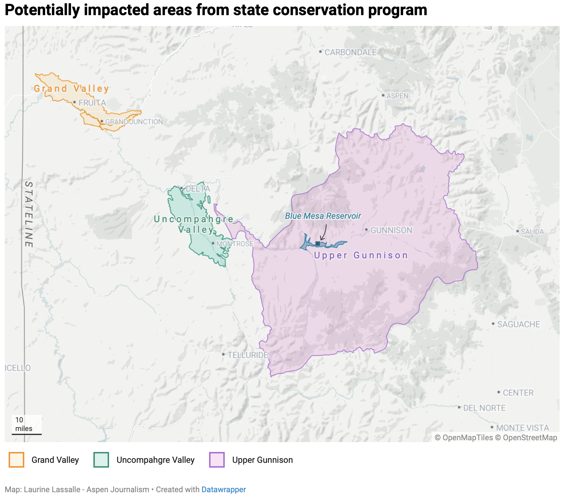
Colorado could most easily wring water from Grand, Uncompahgre, Upper Gunnison valleys
Western Slope water managers are raising concerns that the legal tools used under Colorado’s new conservation program could cause negative impacts to local communities and the state’s agricultural industry.
In a letter to the state water board, the Glenwood Springs-based Colorado River Water Conservation District said it is concerned that the legal mechanisms state officials plan to use to move conserved water into downstream reservoirs may mean certain geographic areas are more likely to give up water. The River District also says the program’s framework should be set by lawmakers – with a significant stakeholder process – during the 2027 session, instead of by the Colorado Water Conservation Board and state Division of Water Resources officials.
At its July meeting, River District staff presented a map of the river basins in its 15-county region, showing which areas were most likely to participate in a conservation program. The Uncompahgre River basin; Dolores River basin; Colorado River in the Grand Valley; White River near Rangely; and Green River, Little Snake; and the Yampa in the Maybell/ Lily Park area were the most likely regions to see participation in a new state conservation program.
“What it shows is the potential for the disparate impacts,” River District General Manager Andy Mueller said at the July board meeting. “And because it’s so easy to pay someone in the Grand Valley for a full [growing] season, that’s going to be the inclination. That’s the easy thing.”
In July, officials from the CWCB and Division of Water Resources unveiled what they are calling a “near-term contribution program,” designed to pay water users in the Upper Colorado River Basin (Colorado, New Mexico, Utah and Wyoming) to voluntarily cut back for the next two years. The state of Colorado will run its own program, alongside similar programs in Utah and Wyoming, using $100 million in promised funding from the U.S. Bureau of Reclamation.
“We have this federal funding available to us and to bring those funds into Colorado, we need to hit the ground running and start the application window,” Amy Ostdiek, interstate section chief at the CWCB, said in an interview with Aspen Journalism. “So we are looking at doing this with the tools we have available under the law as it exists today. And that’s just kind of the reality of the timing of it.”
Shepherding vs. existing authorities
One of the complications of setting up a contribution program are the legal tools used to move water saved upstream to either Lake Powell or Blue Mesa Reservoir, where the state can then get credit from Reclamation for the stored water. One of the criticisms of past pilot conservation programs was that the water was not tracked to Lake Powell nor measured to see how much ended up there.
State lawmakers would need to pass a law to ensure that conserved water is protected as it moves through the river system so that it reaches a specified downstream reservoir without being taken by other water users along the way, a process known as “shepherding.” State officials believe they have the legal authority to shepherd water across the state line only in the case of a call from the Lower Basin states (California, Arizona and Nevada). And so far, the Lower Basin has never placed a compact call.
That means the most straightforward places to wring water from the state are the Grand Valley, the Uncompahgre Valley and the Upper Gunnison Valley. The irrigation districts of the Grand and Uncompahgre valleys are close to the state line and the Upper Gunnison Valley is just above Blue Mesa, so the majority of water conserved in these locations will get to where it needs to go without the state Division of Water Resources having to actively shepherd it.
The River District has long warned that these types of programs, if not done carefully, could cause negative economic impacts by removing water from the Western Slope’s rural agricultural communities.
“Without shepherding, you end up with the potential that there are certain areas that are targeted and can produce water in this program and other areas that cannot,” Mueller said. “Therefore, you end up with these disproportionate impacts that we’ve been concerned about.”
Sonia Chavez is the general manager of the Upper Gunnison River Water Conservancy District, one of the areas that could be singled out. The 59,000 irrigated acres of agricultural land in the district produces mostly hay and is above the state’s largest reservoir, Blue Mesa, where state officials plan to store water conserved under the program.
“That has not been lost on us that we are the only community sitting above a federal reservoir in the state of Colorado,” Chavez said.
State officials say they intend to use their “existing authorities” for this new program, without the change in state law needed to allow shepherding. But the precise definition of existing authorities is still unclear. Officials said it could include loans of conserved water to the state’s instream flow program or releasing water from Blue Mesa Reservoir at times of year when downstream users won’t pick it up, so the water is nearly guaranteed to get to the state line.
The River District’s letter asks the CWCB for more clarity on the definition of existing authorities and how they would be used as part of a contribution program.
From left, Interstate Section Chief at the CWCB Amy Ostdiek, Colorado representative to the Upper Colorado River Commission Becky Mitchell and State Engineer Jason Ullmann, speak on a panel at Colorado Water Congress on August 20, 2026 in Steamboat Springs. State officials are rolling out a water conservation program that would pay water users to temporarily cut back. CREDIT: HEATHER SACKETT/ASPEN JOURNALISM
Lawmaker involvement
The creation of a conservation program for Colorado comes at a critical time for the basin, which remains locked in the grip of a historic drought, combined with a management crisis. With the seven states that share the river still unable to find agreement on a new framework after more than two years of failed negotiations, the federal government has stepped in with its own two-year operating plan. That plan, which was released last week and includes cuts to water use in the Lower Basin, immediately triggered a lawsuit from the state of Nevada.
While the Lower Basin states are subject to mandatory cuts under the federal plan, the Upper Basin is not. But the four Upper Basin states have offered to voluntarily contribute 100,000 acre-feet of water over the next two years, when conditions allow, which would be set forth in a parallel agreement with Reclamation separate from the federal management plan. Colorado’s conservation program is an effort to make good on that promise.
“We’re in the post-2026 world, and I think that acting now and doing what we can with the authorities that we have shows Colorado’s commitment and demonstrates that we are at the table in a meaningful way,” Ostdiek said. “We think it’s important, for various reasons, to move forward with this now.”
In its letter, the River District also asks for the state to limit the criteria it uses to approve participation to a one-year, temporary program so lawmakers can use the 2027 session to use a stakeholder process to come up with a framework for a future program beginning in 2028.
“The Colorado River District has long advocated that any government action that facilitates a Colorado River conserved consumptive use program inside the State of Colorado – or directs the Colorado State Engineer to shepherd conserved water to the state line, whether done under existing authorities or otherwise – must only be done through legislation enacted by the Colorado General Assembly,” the River District’s letter reads.
At a June hearing of the state’s Water Resources and Agriculture Review Committee, lawmakers told state officials that the legislature should be involved in the creation of a conservation program.
But putting the conservation issue – which remains controversial – before stakeholders and lawmakers hasn’t yielded results in the past. In 2023, a 17-member, state-wide drought task force, was supposed to make recommendations to lawmakers about what a conservation program should look like. The group could not agree and did not advance any recommendations on that topic, with some members saying a state conservation program was premature.
And at an August 2025 meeting of the Water Resources and Agricultural Review Committee, some Delta County ranchers asked lawmakers to consider a bill to allow shepherding during the 2026 session. They did not.
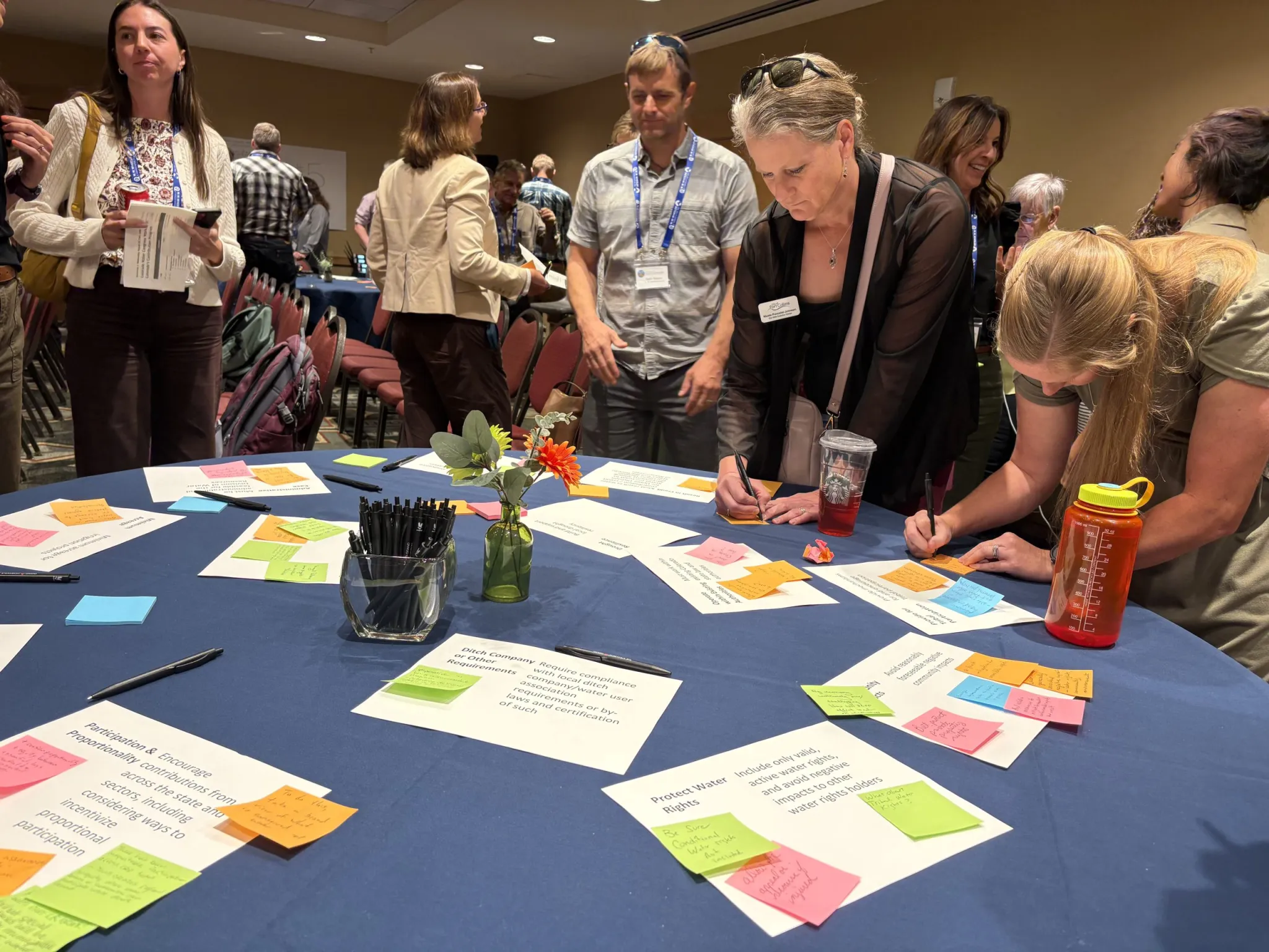
State officials held a workshop to get feedback about a water conservation program at Colorado Water Congress Aug. 19 in Steamboat Springs. Water users have for years expressed concerns about equity and protecting water rights in programs like this. CREDIT: HEATHER SACKETT/ASPEN JOURNALISM
CWCB taking feedback
CWCB officials are currently taking comments and feedback on the contribution program. They held a well-attended workshop for water users on August 19, 2026 at Colorado Water Congress in Steamboat Springs. Attendees had many of the same lingering concerns that have been voiced for years, including how to protect water rights and how to encourage participation across the state.
State officials plan to offer different amounts of compensation to participating water users to account for the difference in the value of relatively cheap water on the Western Slope versus more expensive water on the Front Range. So far, in previous pilot conservation programs, every participant has been a Western Slope water user.
Western Slope agricultural water users have long said that if they don’t see comparable cuts being taken by Front Range municipalities, which collectively draw about 500,000 acre-feet from the headwaters of the Colorado River each year, that they won’t want to participate. They don’t want Front Range urban growth to be fueled by water cuts west of the Continental Divide.
At the workshop, Northern Water’s Director of Engineering Kyle Whitaker tried to put that fear to rest, saying the water provider, which supplies water to farms and communities on the Front Range like Fort Collins, Boulder and Longmont through its Colorado-Big Thompson project, would participate in future conservation programs.
“As transmountain diverters to the east, I only speak for Northern Water, and we will participate from here going forward,” Whitaker said. “We’ve been working on things to be a part of this for a number of years now, and those are finally in place.”
The CWCB is set to consider the criteria for program participation at its September meeting.
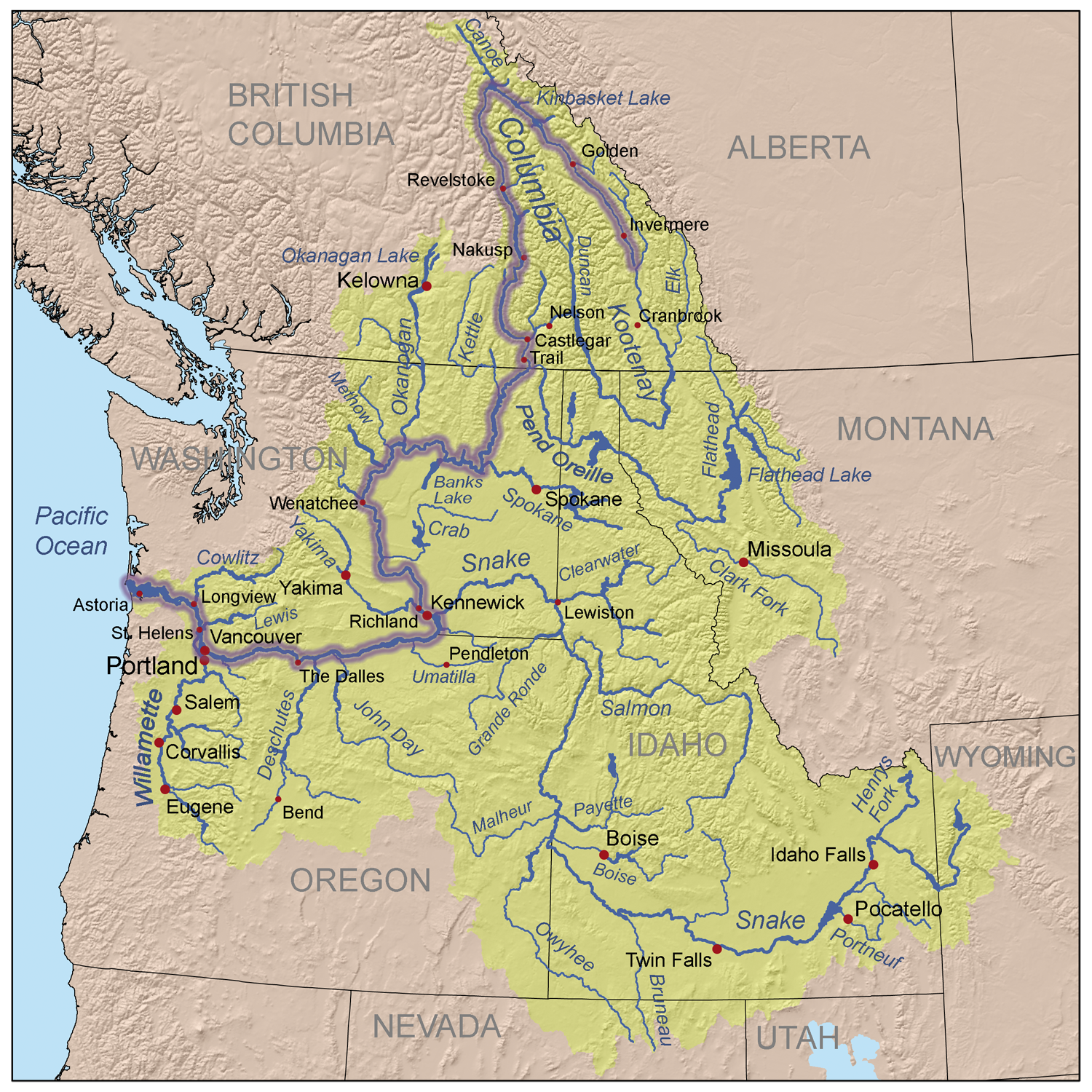
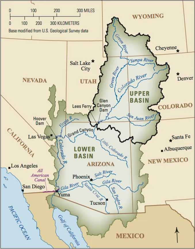
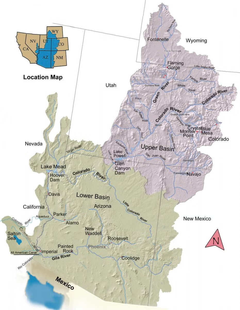
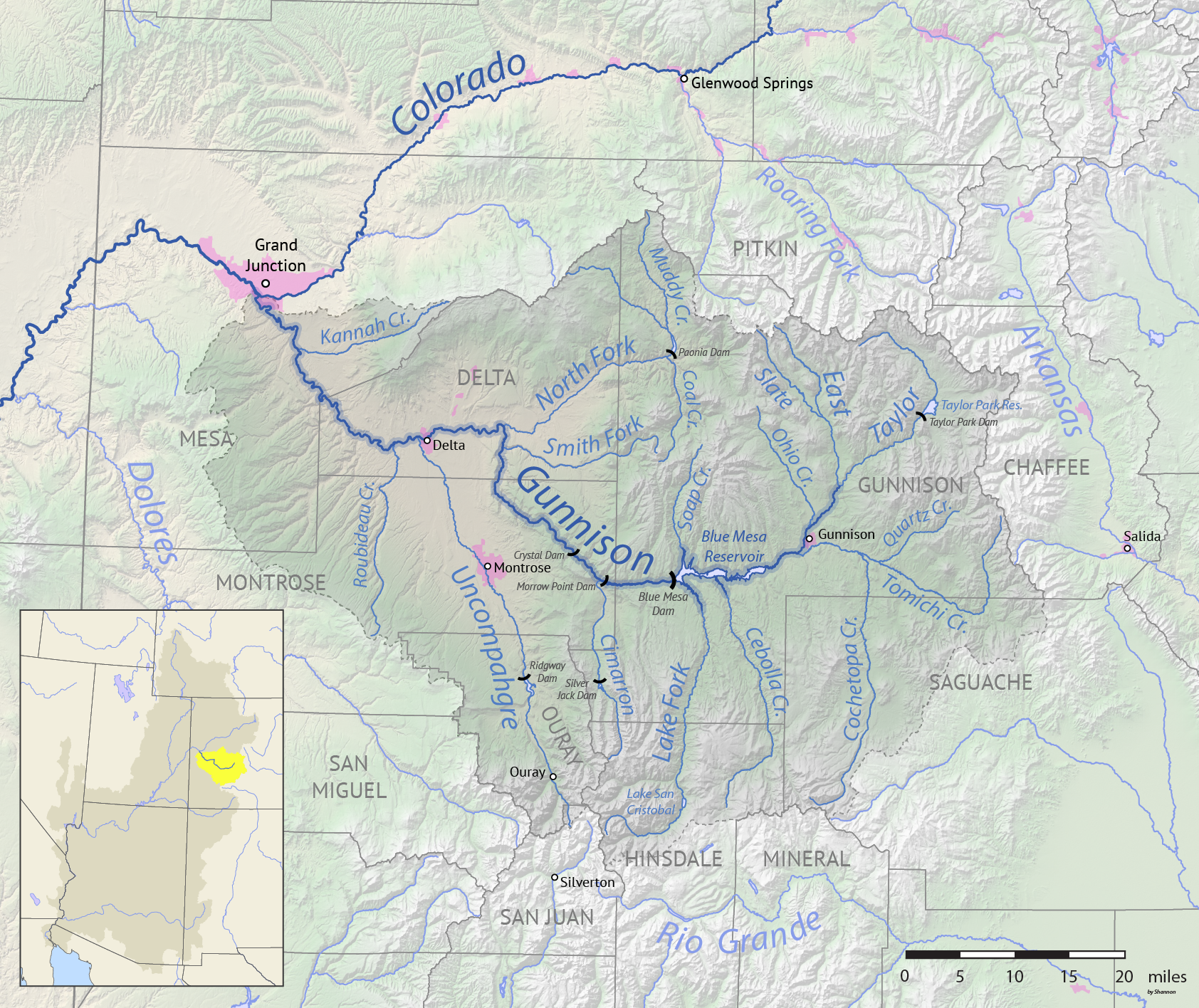
Map of the Colorado River drainage basin, created using USGS data. By Shannon1 Creative Commons Attribution-Share Alike 4.0
Click the link to read the article on the InkStain website (Karl Flessa):
August 20, 2026
In the classic Monty Python sketch, a customer returns to the pet shop where, just 30 minutes ago, he purchased a parrot. He complains that the parrot is dead. The shopkeeper tries to convince the customer the parrot is only resting or is stunned.
In the ensuing argument, the customer uses no fewer than eighteen euphemisms: “This parrot is definitely deceased…demised…passed on…no more…ceased to be…expired…gone to meet his maker…a stiff…bereft of life…rests in peace…pushing up the daisies…metabolic processes are now history…off the twig…kicked the bucket…shuffled off his mortal coil…run down the curtain…joined the bleedin’ choir invisible.”
Indeed, the parrot was nailed to its perch, already dead when the customer bought it.
The Compact and its subsequent agreements are as dead as that parrot.
The Compact is dead because it is founded on a false premise: a river that can produce the prescribed amount of water.
The Compact is dead because it is unjust: neither the Tribes nor nature participate in negotiations.
The Compact is dead because it doesn’t work. The Basin States are locked in battle; the Federal government tinkers and dithers.
In the longer version of the sketch, the shopkeeper goes to the back in search of a live replacement, returning to report “…we’re right out of parrots.”
So are we.
We need a new Compact.
Proposals are not lacking: proportional allocations, Tribal standing, a whole-basin approach, adjustments based on actual flows, a basin authority, nature’s fair share, interstate trading… .
What’s lacking is the courage to change. [ed. emphasis mine]
The Compact is a dead parrot.
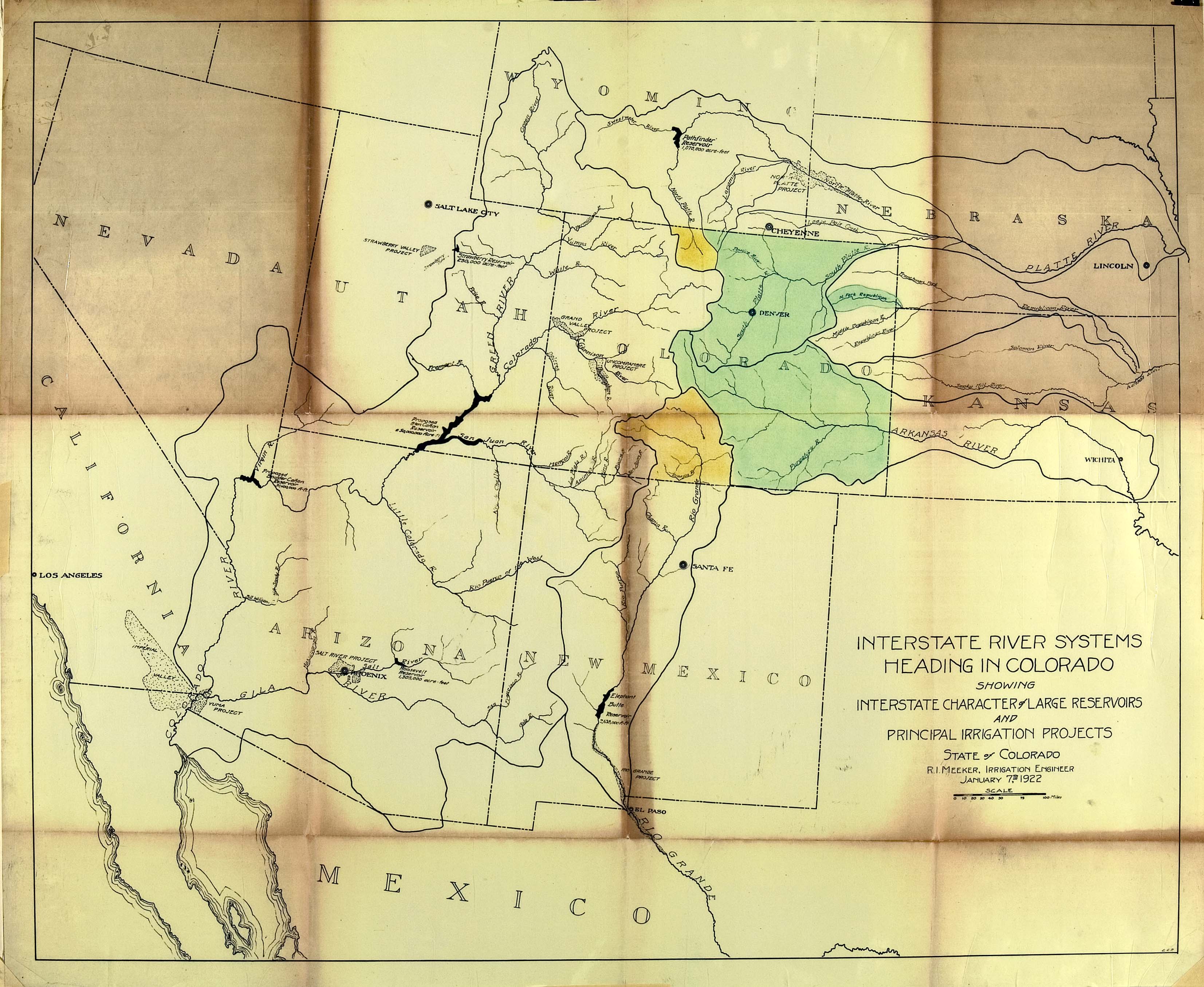
Delph Carpenter’s original map showing a reservoir at Glen Canyon and one at Black Canyon via Greg Hobbs
Central Arizona Project map via Mountain Town News
Click the link to read the article on the KTAR website (Heidi Hommel). Here’s an excerpt:
August 26, 2026
The Upper Basin is on the verge of violating the Colorado River Compact for the first time in the agreement’s 104-year history, failing to send enough water downstream to the Lower Basin, Central Arizona Project President Terry Goddard told KTAR News 92.3 FM on Monday…Goddard said the new framework from the U.S. Bureau of Reclamation that will guide operations through 2036 could make it worse…
“We have a violation of the compact either today or within the next month,” Goddard said.
The compact requires the Upper Basin to deliver 75 million acre-feet to the Lower Basin over any rolling 10-year period, averaging 7.5 million acre-feet a year. Goddard said the Upper Basin is falling short of that obligation for the first time in the compact’s history, releasing only 6 million acre-feet this year and running right at the 10-year threshold. [ed. As Ed Millard says, the action is not from the Upper Basin but from Reclamation]
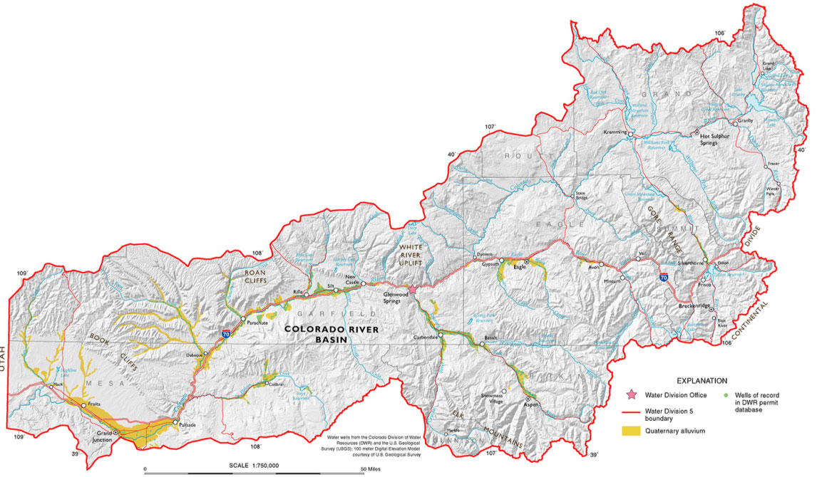
Map of the Colorado River drainage basin, created using USGS data. By Shannon1 Creative Commons Attribution-Share Alike 4.0
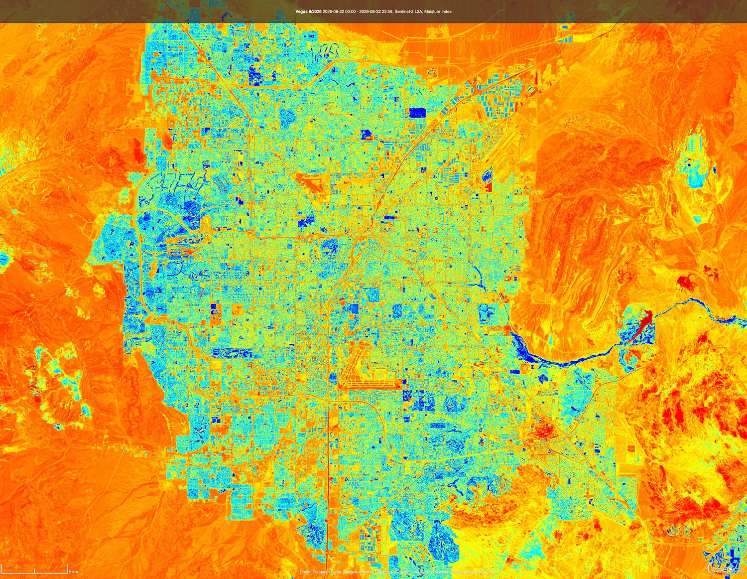
A moisture index satellite image of Las Vegas, Nevada. Southern Nevada stands to lose as much as 71% of its Colorado River allotment under the Department of Interior’s operating guidelines for the river and its two largest reservoirs. Source: Copernicus Browser.
THE NEWS:The U.S. Interior Department on Friday handed down the operating guidelines for the Colorado River for the next two years, while also finalizing the 10-year decision framework that will guide these plans. And on Monday, Nevada filed a lawsuit challenging both the framework and operating plan, saying that potential shortages required by the plan could cause “cause devastating environmental, socioeconomic, and health and human safety impacts to southern Nevada and its citizens.”
THE CONTEXT: Interior, i.e. the Bureau of Reclamation, did two things. The first was to hand down a record of decision on the framework that will guide operating plans for the next decade, which I wrote about here, so I’ll skip the details this time.
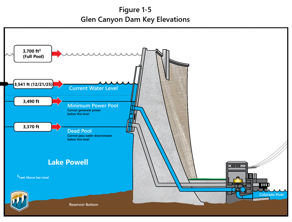
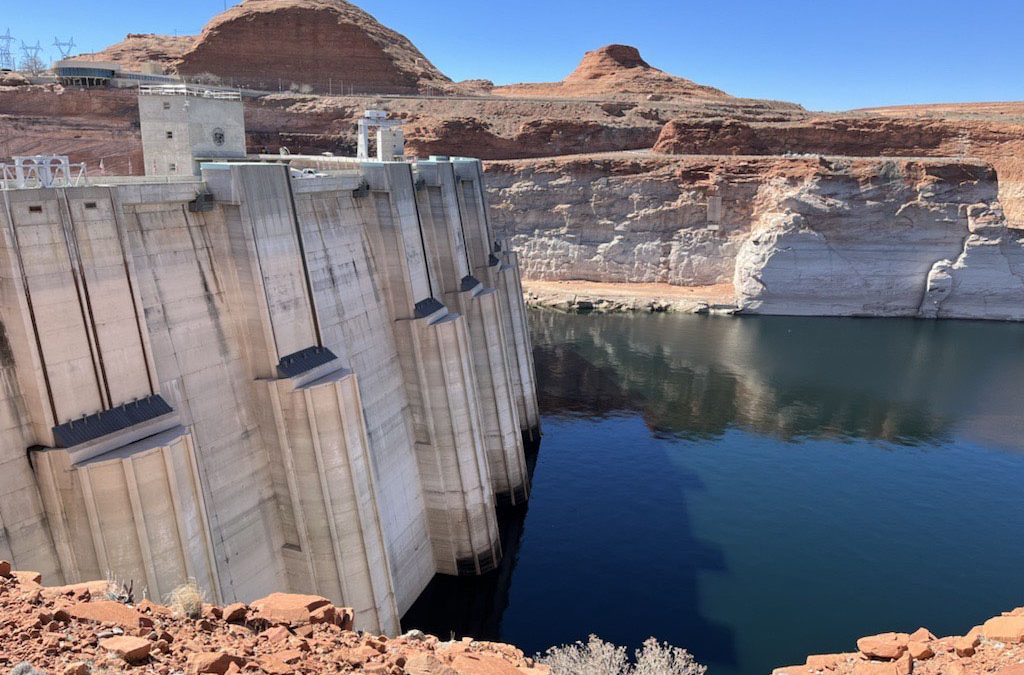
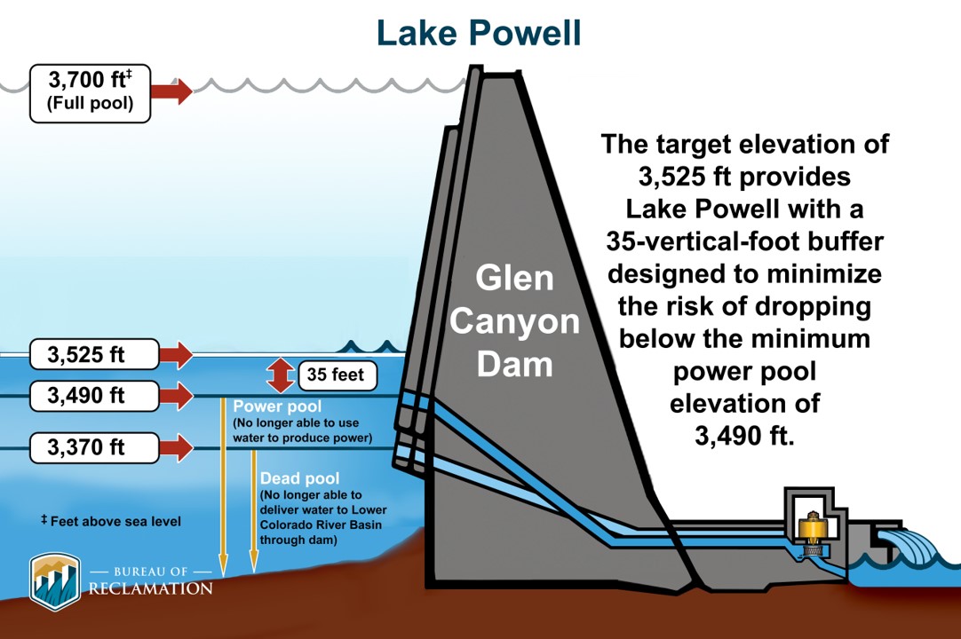
They also released a more specific plan for the 2027 and 2028 operating years. In the new plan, the feds affirm their commitment to “defending” minimum power pool in Lake Powell, or a reservoir surface elevation of 3,490 feet. When the water falls below this level, water can no longer be released via the penstocks and hydropower turbines, so it must all go through the lower river outlet works, which weren’t designed for sustained use.
Notably, Reclamation plans to do this by “initially seeking to maintain a minimum elevation of 3,510 feet. This provides an operational buffer and provides additional flexibility in recognition of the operational risks associated with sustained operations below elevation 3,490 feet … .”
The current elevation is 3,518 feet, meaning it could reach that upper buffer zone of 3,510 feet in October if current levels of decline continue.
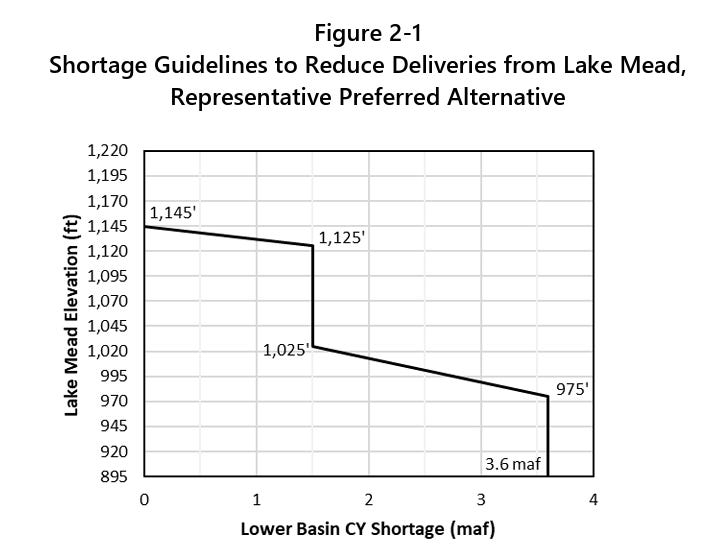
To prevent it from falling any further, Reclamation would cut back releases from Glen Canyon Dam, which in turn would cut flows through the Grand Canyon and into Lake Mead, which would pull down Mead’s levels and trigger mandatory cuts for the Lower Basin users. Under the new operating plan so far, these cuts aren’t as onerous as many feared, and actually match up with what the Lower Basin had proposed to do voluntarily. The deets:
The Lower Basin would receive 6.25 million acre-feet from the Colorado River, or 1.25 MAF below the Colorado River Compact’s allotment of 7.5 MAF.
Arizona would receive 2.04 MAF; California 3.96 MAF; and Nevada 250,000 AF.
This means Arizona would take a 760,000 AF cut; Nevada a 50,000 AF cut; and California a 440,000 AF cut.
Arizona takes the largest cut by percentage and volume because the Central Arizona Project, which delivers most of the state’s Colorado River water, has junior water rights to other big users on the river.
But if reservoir levels continue to drop, then Reclamation could impose further cuts on the Lower Basin, potentially slashing Nevada’s water deliveries by as much as 213,556 acre-feet, or about 71% of its total entitlement of 300,000 acre-feet. This would be truly disastrous for the Las Vegas metro area, which relies on the Colorado River for about 90% of its water. And it’s not like there are a bunch of alfalfa fields the city could “buy and dry” for the water rights.
The Southern Nevada Water Authority has managed to cut overall water consumptionover the last three decades, even as the population has soared, through system-wide efficiencies, incentives, tearing up ornamental grass, water recycling, and extra fees for water gluttons. Las Vegas still has room to conserve, but as Western water scholar John Fleck put it, there “is an absurdity to a plan that would require Las Vegas to cut 71%. That’s existential.”
Even more astonishing than the fact that the federal government is considering virtually drying up one of the Southwest’s major metropolises is their justification for doing so: To protect Glen Canyon Dam and keep it producing hydropower, even at greatly diminished levels, and — though it’s not stated — to keep lake-based recreation somewhat viable.
You have to remember that when the feds vow to defend the 3,500-foot level at Lake Powell, and when they refuse to even consider re-engineering Glen Canyon Dam to allow for releases at lower levels, either by rebuilding the outlet tubes or tunneling a bypass around the dam, they are also saying they are going to trap more than 4 million acre-feet of water behind the dam that could otherwise flow downstream into the Grand Canyon and Lake Mead. That’s enough water to fill Nevada’s entire allotment for more than 13 years that, instead, will be sitting in the reservoir and slowly evaporating.
Nevada’s lawsuit — which is against the federal government, not the Upper Basin states — alleges that the feds’ plan violates the Law of the River. It slams the plan for not explicitly calling for releasing more water from Upper Basin reservoirs to prop up Powell, does not require Upper Basin states to make any cuts, and fails to consider a long-term alternative or engineered solution alternative to address Glen Canyon’s infrastructure limitations. The plan also does not account for its potential impacts on hydropower production at Hoover Dam, which drops off steeply as reservoir levels decline (meaning that preserving power output at Glen Canyon could lead to a net reduction in combined output from the two dams).
Save the Colorado, a river advocacy group, came out in support of Nevada’s lawsuit in a written statement. “Las Vegas has one of the best water conservation programs in the entire U.S.,” said Gary Wockner, the group’s executive director. “Penalizing Las Vegas for water use is like penalizing an obese person who lost a lot of weight taking GLP1s.”
Rough Times at the national parks these days. In Bryce Canyon, a sudden thunderstorm left visitors stranded on trails and requiring rescue, with two of them transported to a hospital for hypothermia. It also unleashed some serious flash flooding. In Zion National Park, a rockslide narrowly missed a shuttle bus and forced the closure of a portion of the Zion Canyon Scenic Drive. And in Canyonlands, officials were searching for a missing individual in Horseshoe Canyon, a remote area north of the park’s Maze district. Temperatures in the area were in the 90s. In Death Valley, a French tourist died after his car got stuck in the mud on a remote road in 116° F heat.
The video below shows flooding near Tropic, Utah, downstream from Bryce Canyon National Park. Source: Garfield County Sheriff.
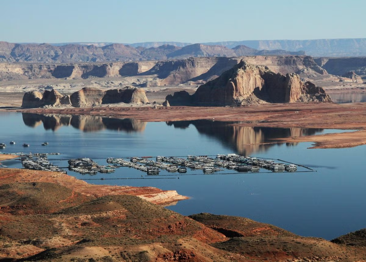
In May, I wrote about how climate change and aridification and a shrinking Lake Powell were coming for the Bullfrog Marina, on the northwest side of the reservoir. The water was simply getting too low for the marina to remain viable, so they were planning on moving it across the reservoir to Halls Crossing Marina.
At the time, it was not yet clear how lower water levels and the marina’s removal might affect visitation to the remote area. Now preliminary numbers are in:
67,277: Total recreation visitors to the Bullfrog District of Glen Canyon National Recreation Area, January through July 2025
44,206: Total recreation visitors to the Bullfrog District, January through July 2026.
That’s a decrease of over 23,000 visits, or a 34% drop. Even more dramatic is the drop in overnight stays in July, from over 47,000 in 2025 to just 17,000 in 2026. Then did folks make the long drive over to Halls Crossing, instead? It appears that some of them may have once the marina was moved, but overall this year visitation is also down on the northeast side of the reservoir.
18,023: Total recreation visitors to the Halls Crossing District of Glen Canyon National Recreation Area, January through July 2025.
15,099: Total recreation visitors to the Halls Crossing District, January through July 2026.
That’s a decrease of 2,944 visits, or a 19% drop. This may not all be related directly to the dropping lake levels. Horseshoe Bend, which is in Glen Canyon National Recreation Area but downstream from the reservoir, has also seen a significant drop off in visitors this spring and summer. In a future dispatch I’ll take a closer look at tourism numbers in general to get a better sense of how widespread the declines are.
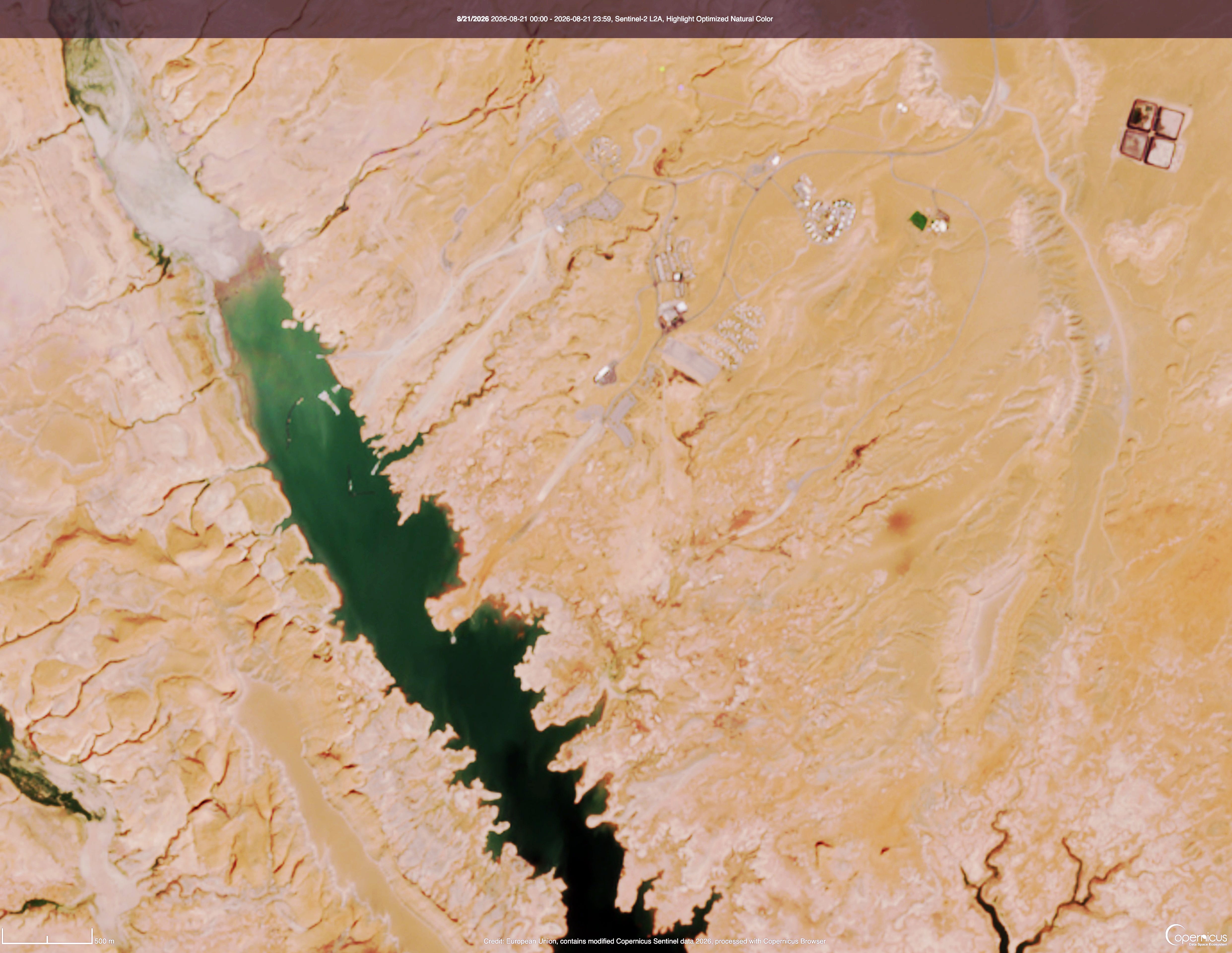
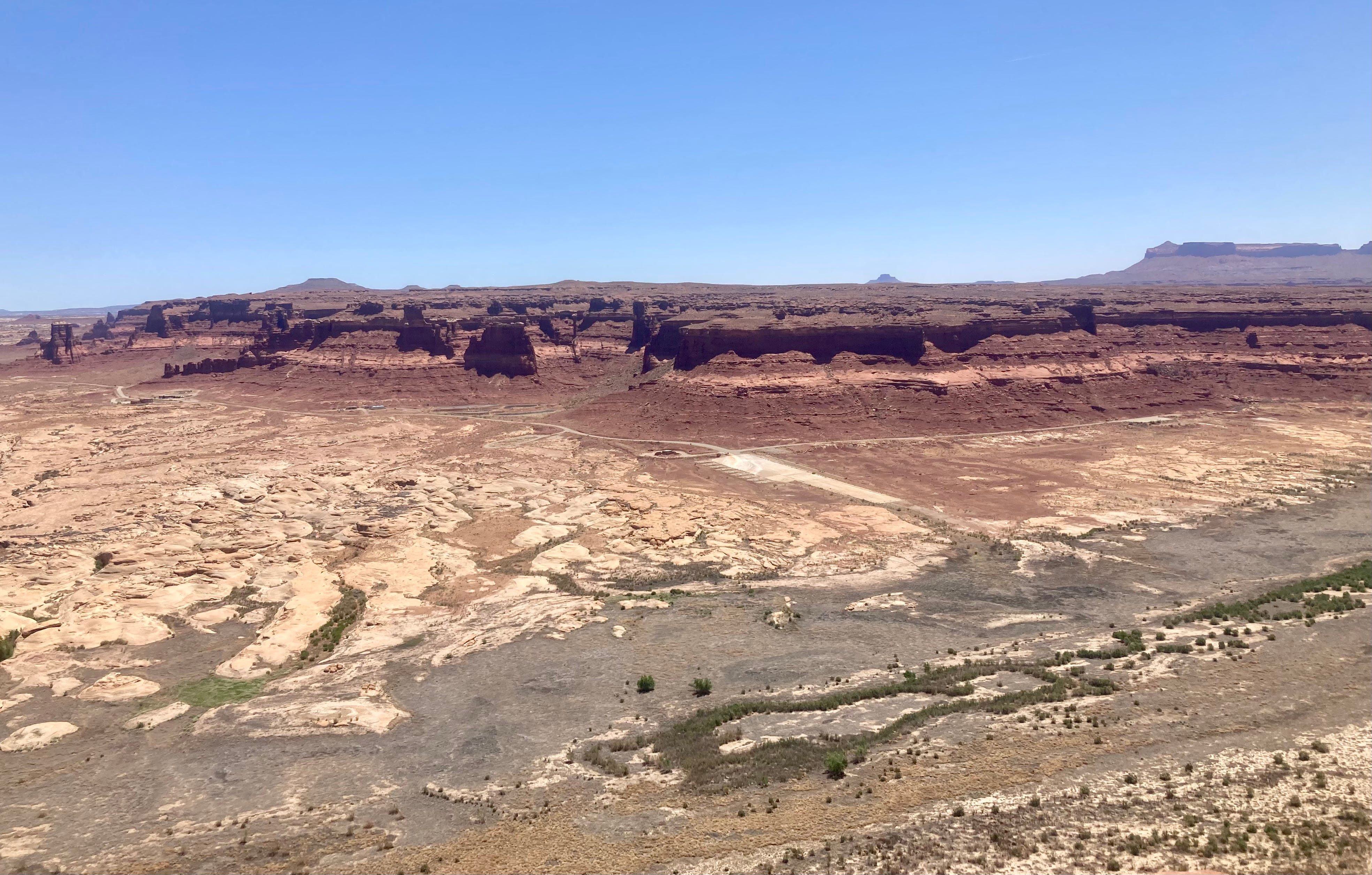
And now for the images showing Bullfrog with the marina, and without. The first image is from August 2024, when the reservoir’s surface elevation was at about 3,580 feet. The marina was still there, and the boat ramps still made it all the way to the water. The second image is from August 2026, with a surface level of just over 3,518 feet. Look closely and you’ll see the marina is gone, and the ramps are high and dry.
Bullfrog Bay and Marina, August 2024. Source: Copernicus.
Bullfrog Bay and no marina, August 2026. Source: Copernicus.
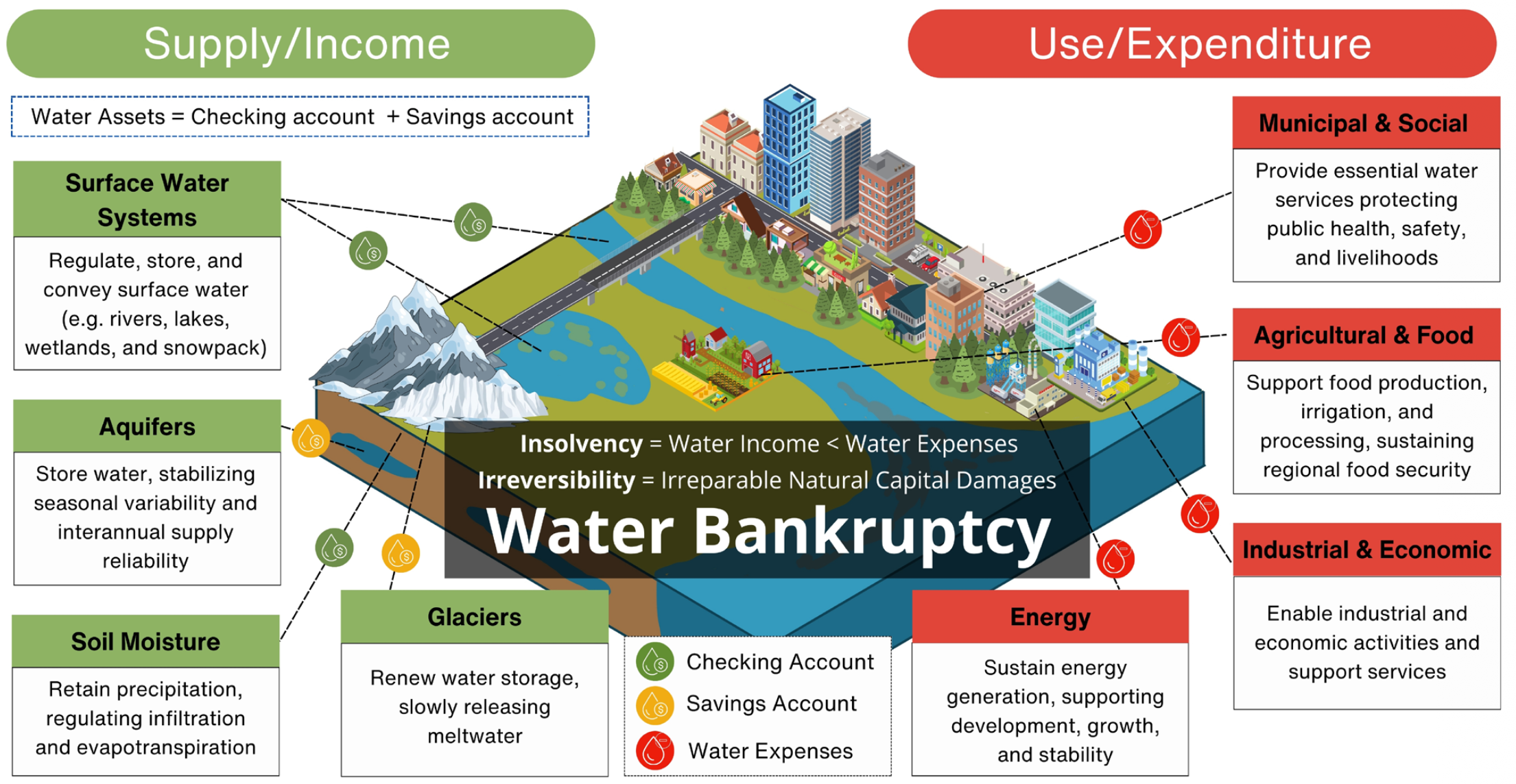
A simple illustration of water income and water expenses in a human–water system. Water bankruptcy is the outcome of both insolvency and irreversibility conditions, i.e., when water use (expenditure) exceeds water supply (renewable and non-renewable assets) for an extended period resulting in irreparable damages to the underlying natural capital that contributes to water production and stability of the hydrological cycle.
Click the link to read the article on the Sibley’s Rivers website (George Sibley):
‘Amid chronic groundwater depletion, water overallocation, land and soil degradation, deforestation, and pollution, all compounded by global heating, a UN report today declared the dawn of an era of global water bankruptcy, inviting world leaders to facilitate honest, science-based adaptation to a new reality.’
Our Colorado River made their list of exemplary global ‘hot spots’ for bankruptcy, with the observation that ‘the Colorado River and its reservoirs have become symbols of over-promised water.’
Udall/Overpeck 4-panel Figure Colorado River temperature/precipitation/natural flows with trend. Lake Mead and Lake Powell storage. Updated through Water Year 2025. Note the tiny points on the annual data so that you can flyspeck the individual years. Credit: Brad Udall
You’ve seen the word ‘crisis’ used frequently this year in the countless morbid articles about the Colorado River. But the UNU Institute director Kaveh Madani argued that we are now ‘post-crisis’: the term ‘crisis’ implies a deviation from the normal, a disruption to be dealt with in order to get back to normal, but there is now, Madani says, no going back to what passed for ‘normal’ in the last century. [ed. emphasis mine]
The study indicates that we have drained too many aquifers, resulting in subsidence that destroys the aquifers for the rest of the geological age; we have lost high-storage wetlands to gullying and lowered water tables; we have spread too much surface water out to dry under an atmosphere heating up incrementally with every additional gallon of fossil fuel we burn; desertification spreads in our wake; et cetera, et cetera. As a result:
The report makes the case for a fundamental shift in the global water agenda—from repeatedly reacting to emergencies to “bankruptcy management.” That means confronting overshoot with transparent water accounting, enforceable limits, and protection of the water-related natural capital that produces and stores water—aquifers, wetlands, soils, rivers, and glaciers—while ensuring transitions are explicitly equity-oriented and protect vulnerable communities and livelihoods.
There is in this research paper the kind of lovely naivete that one finds in most of the analyses of Big Issues today (climate change, systemic racism, corporate personhood versus people, etc.); there is an underlying conviction that when the facts are all laid out, we will rationally accept that, yes, we are indeed in a bankrupt situation. And so we will all sit down together, like rational beings would, and work out ways to resolve the ‘reality deficit’ between what has been promised and what can be delivered.
This ignores the fact that, when we are first confronted with evidence of something so big in its threat to our way of life, that its correction might require creating a whole new way of life, our first response is to say, ‘this can’t be so.’ There has to be a mistake. And a long winding road leads on, into and through a morass of denial, anger, blames cast, responsibilities denied, hopeful negotiations and underlying despair – the whole medieval pilgrim’s Slough of Despond that must be negotiated before we might actually sit down together and work out some way of resolving the ‘reality deficit.’
There is, however, a kind of honesty in coming around to realizing – and acknowledging – that a system might be bankrupt. Bankruptcy is not necessarily the end song of what has become bankrupt, although it can be (Chapter 7 bankruptcy). It can instead be a time of operational or financial reorganization, aa time for acknowledging circumstances, conditions and misconceptions not originally taken into account that, accounted for, might enable a measure of eventual recovery and even success.
The seven Colorado River Basin states, still stuck in the zomboid Colorado River Compact, are not there yet, but the Bureau of Reclamation might be getting there. On the viable assumption that the seven states will not come up with a last-minute plan before the end of September and expiration of the Interim and Interim Interim Guidelines, they are preparing to institute a temporary plan that will maintain functionality in the river storage and delivery system, with (they hope) no embarrassing ‘dead pool’ episodes – which basically means getting and keeping as much water as possible in the two big reservoirs, Mead and Powell, and that can only happen at considerable cost to users below the big reservoirs.
The Bureau plan will not be carved in stone for forever like the Colorado River Compact; the Bureau will basically be planning operations for two-year periods, through the coming decade; every two years, the parties of interest will reconvene to review and revise the operating plan as circumstances require. This ‘adaptive’ approach makes sense in a bankruptcy situation in which the future is mostly unknown. [ed. emphasis mine]
The plan really has no surprises for anyone who remembers the 2022 bolt of reality that caused Bureau Commissioner Camille Touton to tell the water leaders in the seven states to immediately plan to voluntarily cut 2-4 million acre-feet (maf) of water use – basically a quarter of river use at that time – or the Interior Department would do it for them. That – in the centennial year of the Compact – is probably a good marker for the Bureau’s acknowledgement that we were beyond crisis, and slipping into bankruptcy.
The structural deficit refers to the consumption by Lower Basin states of more water than enters Lake Mead each year. The deficit, which includes losses from evaporation, is estimated at 1.2 million acre-feet a year. (Image: Central Arizona Project circa 2019)
That 2022 siren call was met by the Lower Basin states agreeing to finally take the Lower Basin system losses (evaporation, etc.) and their half of the Mexican obligation out of their river-use shares rather than out of Mead storage until the 2027 water year – provided they would be paid to do so. The absence of ‘surplus flows’ to take care of those losses – ~1.25 maf – from the coming online of the Central Arizona Project was a principal source of the draining of the big reservoirs, the so-called ‘structural deficit,’ 30 maf of storage gifted to the Lower Basin.
(A side note on this: The Upper Basin states, since a 1970 Law-of-the-River agreement, have been regularly sending downstream their 750,000 acre-feet for the Mexican obligation and absorbing as part of their whatever’s-left-over share of the river the ~400,000 acre-feet of Upper Basin system losses. The four states have never asked for or been paid for doing that.)
But that 1.25 maf of voluntary shortages was only a large fraction of the 2-4 maf of cuts the Bureau said needed to happen. So the Bureau’s original 2027-28 plan announcement in late July included cuts of up to 40 percent for the states below Mead Reservoir (Arizona, California and Nevada) – roughly equivalent to the 2022 request for 2-4 maf in cuts. The three downriver states countered that with an offer to permanently do the same 1.25 maf cut (with payment) for 2027-28 they were doing for 2025-26, with intimations of lawsuits if the Bureau pushed too far beyond that.
Arizona has led the countercharge from the states below Mead Reservoir – being the state with the most to lose, since the junior status of the Central Arizona Project means it would be practically shut down by 40 percent cuts in usage.
A letter to the Interior Department from Tom Buschatzky, Arizona’s Director of Water Resources, castigated the Bureau plan for making no mention of the Colorado River Compact and the Law of the River (LOTR). The letter insisted that Article III(c) and (d) of the Compact be executed to the letter as stated in the LOTR 1970 agreement: that a minimum of 8.23 maf be released from Powell Reservoir every year – the Compact commitment of 7.5 maf per year on average passing Lee Ferry, plus the Upper Basin’s share of the Mexican obligation (750,000 af/year).
In their August 21 announcement of the more detailed plan for 2027-28, the Bureau backed down from the 40 percent number, and now wants a 20 percent reduction in use for the two years – more in line with the Lower Basin’s willingness to continue taking care of its own system losses and Mexican share, but requiring some additional cuts – and avoided discussion of the Compact issue raised. It will, however, probably be pushing for more cuts in the 2028 discussions for the 2029-30 plan renewal; the Bureau still feels that it needs at least 3 maf in permanent cuts to begin any hope of turning the current near-bankruptcy around, and bringing demand in line with at least current supply.
The Bureau would also like the seven states to be reviewing, revising and executing the two-year plans consensually by 2036, rather than imposing it on them. But Arizona, according to the Buschatzky letter, wants a ‘longer, more comprehensive’ plan from the states, consistent with the LOTR, and ‘does not accept a framework that gives the federal government the discretion to select from a wide range of alternatives—including catastrophic cuts to the Lower Basin—every two years for the next decade.’
‘Bankruptcy management’ would seem to argue that the Colorado River Compact should be on the table along with everything else – including the nonexistence of the 18 maf river for which the Compact was written. A detailed analysis of the current situation by the ‘River Elders’ – the Kuhn-Schmidt-Castle group – suggested that ‘Basin water users must focus on solutions to the fundamental, wet-water math problem, rather than legal arguments over paper water.’ [ed. emphasis mine]
Nonetheless, Buschatzke’s letter states that ‘Arizona reserves the right to seek the resolution of its Compact rights in an appropriate judicial forum.’ The states are not yet willing to acknowledge the bankruptcy of the Compact – a Humpty-Dumpty that not all the patches and bandaids of the Law of the River can put back together for an ever-shrinking 21st century Colorado River.
That, more or less, is where the river system’s future sits as of August 21. There will – thanks to the Bureau – be a plan for moving carefully into the future, a two-year step at time. A big question is how hard the Bureau will begin to push for the 3-4 maf in permanent cuts by users necessary to stop the march into real dead-pool bankruptcy of the system – leading to another big question: whether the Compact nostalgitarians will push the system into dead-pool bankruptcy by suing the Bureau/Interior Department over paper water, tying things up in court for another several years.
Ah, the lovely Slough of Despond. There with Henry: ‘All day the sun has shone on the surface of some savage swamp, where the single spruce stands hung with usnea lichens, and small hawks circulate above, and the chickadee lisps among the evergreens, and the partridge and rabbit skulk beneath; but now a more dismal and fitting day dawns, and a different race of creatures awakes to express the meaning of Nature there….’ Bankruptcy, the Apocalypse – only the end for those who fail to see that something else is always struggling for a chance to be born; don’t put a period where God (or Nature) would put a comma (Gracie Allen). As Henry also observed, ‘The light which puts out our eyes is darkness to us. Only that day dawns to which we are awake….’
Next post, I want to go back to the ‘desert river’ concept to think a little outside the (Compact) box.
Map of the Colorado River drainage basin, created using USGS data. By Shannon1 Creative Commons Attribution-Share Alike 4.0
Click the link to read the release on the ADWR website:
August 21, 2026
After more than three years of difficult negotiations over post-2026 Colorado River Operations guidelines, Arizona and the Lower Basin states have created a level of stability for the Colorado River system with the adoption of the 2027-2028 operating guidelines in the Record of Decision. While the framework for years 3-10 continues to be of concern, we applaud the Department of the Interior for clarifying the decision-making process for operations beyond 2028. That outcome allows for continued negotiations for years 3-10 while preserving our ability to protect Arizona’s legal rights to Colorado River water.
We will continue to work with our partners in Arizona, the Lower Basin and Interior, to finalize the agreements necessary to implement the Lower Basin Plan. With the Record of Decision, the 2027-2028 Operating Guidelines and the supporting agreements in place, we can focus on a longer-term, equitable, basin-wide outcome that includes shared sacrifices along with our Upper Basin partners in an effort to avoid protracted litigation. The actions in the Lower Basin in recent decades to protect the system have demonstrated how much we can accomplish when we all join together as part of the solution. – Tom Buschatzke, Director of the Arizona Department of Water Resources
Tom Buschatzke. Photo credit: Arizona Department of Water Resources
Colorado River negotiators are seen at the 2025 Colorado River Water Users Association Annual Conference. From left to right: Becky Mitchell (Colorado), Tom Buschatzke (Arizona), Brandon Gebhart (Wyoming), and John Entsminger (Nevada). (Photo by Jeniffer Solis/Nevada Current)
Nevada officials filed a federal lawsuit challenging the Trump administration’s order for cuts in water use Monday, marking a major escalation of tensions between the seven states that share the Colorado River. The complaint, filed in the U.S. District Court of Nevada, asserts that the U.S. Bureau of Reclamation’s operating plan unlawfully authorizes the federal government to reduce the state’s allocation of the river by up to 71 percent annually sometime over the next 10 years. Such a cut would slash the state’s share of 300,000 acre-feet down to 86,444 acre-feet. Nevada’s use, after cashing in water recycling credits with its state-of-the-art system, came in at 198,000 acre-feet last year.
“There are four states upstream of us that are facing zero mandatory reductions,” said John Entsminger, general manager of the Southern Nevada Water Authority, in a Monday interview. “That is not going to balance the system. This is a system-wide problem. It requires system-wide solutions.”
Lawyers for the Colorado River Commission of Nevada, the water authority and the state as a whole requested an injunction to halt implementation until federal documents can reflect the toll water cuts would have on Southern Nevada’s $180 billion economy.
“This shortfall will cause devastating environmental, socioeconomic, and health and human safety impacts to southern Nevada and its citizens,” attorneys wrote. “Federal Defendants failed to consider such impacts in any meaningful way.”
While 2027 and 2028 will see allocation cuts that the Lower Basin states of Nevada, California and Arizona have already agreed to, the years 2029 to 2036 could bring much harsher reductions. Entsminger said he felt it was important for Nevada to have its own representation on the issue, but he added he would be surprised if California and Arizona don’t sign on to the lawsuit, considering officials remain aligned in their positions. No mandatory cuts will be imposed on the Upper Basin states of Colorado, Utah, New Mexico and Wyoming. Entsminger submitted a letter to all six Colorado River basin states Monday, saying the state’s decision to sue wasn’t made lightly but that “hiding from reasonable legal interpretations in order to defer hard political decisions helps no one over the long term and further endangers our shared resource.”
Map of the Colorado River drainage basin, created using USGS data. By Shannon1 Creative Commons Attribution-Share Alike 4.0
Earlier that same day, the Department of Interior had issued its record of decision about how it would manage the key dams and hence the river during the two water years beginning in October. This came after Colorado and the six other basin states had failed during two years of negotiations to agree about how to share diminished river flows.
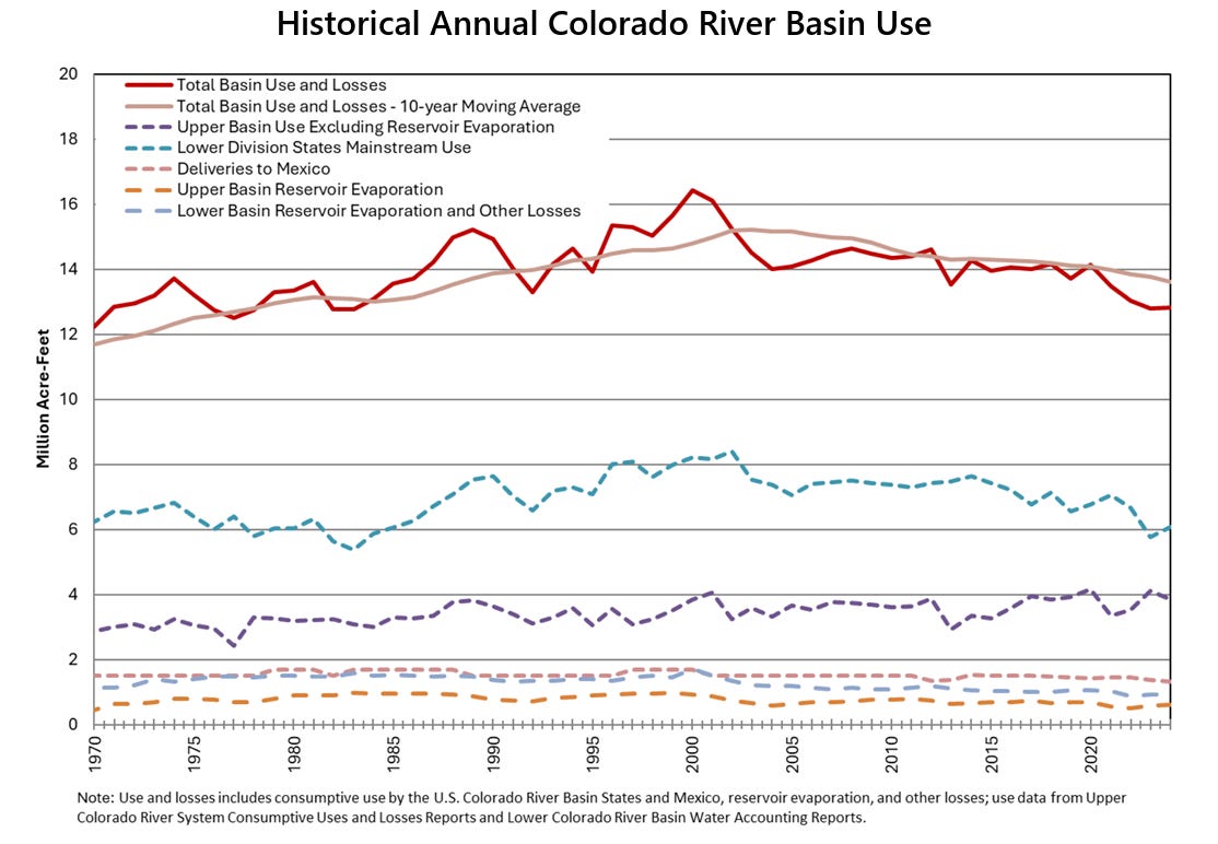
As even schoolboys in Kentucky likely know, the Colorado River has encountered severe problems since 2000. Flows in the river are down 20% and continuing to decline in direct proportion to rising temperatures. The two big reservoirs, Mead and Powell, have declined 75% in stored water.
The lower-basin states, which get their water from these two big reservoirs, had already cut their use significantly. The Department of Interior has ordered the three states to expect 1.25 million acre-feet less water from Mead during the next two years. It also expects the three states to figure out how to store 700,000 acre-feet over the next two years. Colorado and other upper basin states cannot expand water use.
Agriculture users, said Udall, will bear the brunt of these cutbacks. Municipal users — all the cities from Colorado’s Front Range to southern California get water from the river and its tributaries — will have to chip in with water savings. Infrastructure limitations of the two big dams, Hoover and Glen Canyon, when holding little water need to be resolved. For example, penstocks [river outlet tubes] on the two big dams were never designed for day-in, day-out use, as may be necessary with reduced amounts of water. And as for the hydroelectric production? Yes, it’s a small amount but important. It provides backup power.
The process created by the Interior Department — the Bureau of Reclamation is the key agency within Interior — requires new plans every two years for the next decade. Udall sees merit in this approach.
“When the negotiations started, the idea was that we’re going to get a 20-year plan. We got five two-year plans, which you might see as a setback, but I think we might have blundered into something actually useful, because it potentially is true adaptive management, where people get to pay attention repeatedly as this evolves.” [ed. emphasis mine]
Udall also sees strong dynamics producing solutions.
“I think we’re going to see a solution because the people who are involved in the negotiations are hard-working. They’re knowledgeable. They’re intelligent. They have super good relationships with each other. And they know that the chips are down. If they don’t solve it, the solution Mother Nature provides will be downright ugly. I think we will solve this. I actually do.”
When the breakthroughs will occur, Udall said he didn’t know. And he hedged his confidence with caution. “I won’t put bets on this.”
What is clear, though, is that Arizona will be key to solving the conundrum of 21st century flows being far less than 20th century expectations. The river in the last century average 15.2 million acre-feet. Even when it carried healthy volumes of water, though, the river had ceased to reach an embayment of the Pacific Ocean. Flows this century have declined and, since 2020, remarkably so: to an average of just 10 million acre-feet.
Flows will almost certainly decline further. Accumulating greenhouse gas emissions guarantee continued warming, producing reduced flows.
“Western water law is enormously complicated and really inhibits solutions,” he said. “We’ve made a whole bunch of policy mistakes through time, including permanent allocations, assuming way too much water, and enforcing or legalizing really unrealistic policies.”
Whether the framework created by the federal government for finding solutions will work, he said, will depend upon hydrology. In some circles optimism remains that the strong El Niño this year will produce improved precipitation and hence greater flows. And maybe it will, said Udall, but the record on flows during El Nino years has been all over the scattergram. A few very big years — 1983 and 1998 stand out — yes. But some real duds, too. In other words, this coming winter could conceivably be as bad as the past winter. Or, if not as bad, then will continue the downhill slide.
Now rewriting the rules
Udall also made the point that prior agreements were incremental in nature, unlike what the new federal rules represent.
“The rules in 2007 and 2019 were really hard fought, but they were incremental. They were truly incremental. What we’re looking at right now, it’s not incremental. It’s a complete rethink,” he said.
“I think people mistakenly thought that, given the successes in 2007, 2019, we would just kind of waltz our way to new rules. And I think that’s the wrong way to think about what’s going on. This is a really a different deal in 2026.”
This new paradigm imposed by the federal government, Udall went on to say, is the “first global instance where climate change is forcing a complete redo of water management. I think I can make a pretty good case for that.”
Udall/Overpeck 4-panel Figure Colorado River temperature/precipitation/natural flows with trend. Lake Mead and Lake Powell storage. Updated through Water Year 2025. Note the tiny points on the annual data so that you can flyspeck the individual years. Credit: Brad Udall
Udall has become well known at water meetings in Colorado and beyond, particularly during the last decade, in warning that communities and economic sectors dependent upon the Colorado River were headed for trouble. Climate change is water change, he began saying more than 20 years ago. And in 2014, he conducted research along with another scholar, Jonathan Overpeck, that showed the strong correlation between rising temperatures and reduced flows in the river. That science, he said, has strengthened.
Although living in Boulder, Udall in recent years has been affiliated with Colorado State University’s Colorado Water Center. There, he wears the title of senior water and climate research scientist/scholar.
However, Udall is also understood in terms of his family tree. He is a descendant of John D. Lee, the Mormon settler for whom Lee Ferry (also called Lees Ferry) is named. Located in Arizona, near the Utah border, it divides the Colorado River’s upper and lower basins.
Don’t make too much of being a John D. Lee descendant, he said. “He had 21 wives that we know of, and some have suggested he has 800,000 descendants. That might actually be part of the problem with the Colorado River.”
Ken Sleight the original Monkey Wrencher photo via Salon
As for his personal familiarity with the river, Udall divulged that he has rafted the Grand Canyon 45 times, at least some of those in the employ of Ken Sleight, best understood by readers of Edward Abbey’s “Monkey Wrench Gang” as the model for Seldom Seen Smith.
Arizona’s role
In Udall’s view, Arizona is central to solving this 21st century problem. The Central Arizona Project will “see a whole lot less water, but it’s not going to zero. I don’t know quite how that gets revolved, but that’s just so clear,” he said.
The Central Arizona Project delivers water from the Colorado River through 336 miles of canal to metropolitan Phoenix and ultimately Tucson, with farms along the way. It was authorized by Congress in 1968 and completed in 1993. Both his father, Morris, and his uncle, Stewart, were key figures in this. It can deliver 1.6 million acre-feet, the majority of the 2.8 million acre-feet that Arizona was scheduled to receive from the Colorado River under a 1964 court ruling.
As Udall pointed out, farms that got water from the project have received far less since cutbacks began in 2020. And now, more cuts for the farms — and cities — will be coming.
Given an hour for his presentation, far longer than his usual 20- or 30-minute slots, Udall had time to sketch some history, even taking time to define the universal way of measuring water quantities in the basin, the acre-foot.
“The reason that an acre-foot is used is farmers farm in terms of an acre,” he explained. “In the upper basin, you might put a foot or two feet of water on top of an acre to get a hay crop out. In the lower basin, near the Mexico border, you might put 10 feet of water on top of an irrigated field to get 10 different cuttings of alfalfa.”
Credit: The Land Desk
Thoughts about hay
Alfalfa came up in the Q&A. The question, in not so many words, was how to cut back water used to feed livestock. After all, agriculture uses about 75% of the water (after evaporation) in the Colorado River, and alfalfa and other feedstocks comprise a large portion of that. A full hour could have been devoted to that question — and likely left topics on the table. The tension inherent in this topic is revealed in how the Family Farm Alliance describes this push replace animal forage to crop switching: “crop shaming.”
“It’s easy to hate on alfalfa because people don’t eat it, but we kind of do, right? Dairy, ice cream, beef cattle. And the idea that you’re going to tell farmers not to grow alfalfa, which turns out to be a pretty good crop for them in their rotation, probably isn’t going to work very well. You’re probably far better off to say, ‘Hey, here’s your reduced allocation. You use it as you want,’” responded Udall
“I think most people in this room don’t care about corn. We very much care about alfalfa, and its water use, but I’m not sure trying to prohibit farmers from using a crop that’s key in their rotation and actually has some kind of interesting benefits is a suitable way to get there. “
Udall also mentioned the difficulties of crop switching.
“It’s been suggested that ag shift to higher value products that use less water. One way to do that is only grow stuff in the winter because growing in Yuma (Arizona) and Imperial (Valley) in midsummer is not a great idea. But when you ask a farmer to shift produce or products, you ask them to change marketing, you ask them to (change) labor, transportation, storage, equipment, knowledge. You ask them to change a lot of things, and arguably there’s a need to help this transition happen.”
This discussion, he concluded, is one that needs to be had but is very complicated. “It really is going to take a deep dive to figure out how to deal with this.”
You will be able to soon hear what Udall had to say (and see the slides he shared) at the Getches-Wilkinson Center’s site. The history lessons alone make it worth an hour.
A few other snippets:
• “The lower basin wants some contribution from the upper basin (in reducing use) maybe 5% or maybe 2%, but some kind of skin (in the game). And the upper Basin says no way. Until recently, the upper basin wanted to reserve the right to increase its use.”
• Our (Colorado delegate to the Upper Colorado River Commission) Becky Mitchell has recently been saying, you know, none of this gets us any extra water. And we need to move beyond this, and I applaud Becky for saying that.”
• Udall told a fascinating story about the Central Arizona Project. At the time the proposal for federal funding was before Congress, the Upper Colorado River Commission paid a Denver-based engineer to examine the numbers. That engineer’s conclusion: There’s not enough water for the Arizona project once the upper basin uses its full allocation (as defined in the Colorado River Compact of 1922). The number was 1.2 million acre-feet a year. And the two big reservoirs, Mead and Powell, have been losing 1.25 million acre-feet a year.
• The idea in 1968, said Udall, was that the federal government was going to figure out how to augment flows of the Colorado River. One of the ideas was to export water from the Snake River in Wyoming’s Jackson Hole to the Green River and hence the Colorado. Washington Sen. Henry “Scoop” Jackson and other members of Congress from the Pacific Northwest objected. And the augmentation that was part of the thinking never has happened.
Green River Basin
• On the first-in-time, first-in-right premise of Western water law. “You know, first-in-time, first-in-rank gets reinvented by 4-year-olds every day of the year throughout the world. I was here first; it’s mine. And most parents step in and say you’re going to share, right: But not Western water law. It was completely understandable in the 1800s, where you had a few users. But it’s really not so great in modern society. …
“You can’t have a case where 1,500 famers deprive 5 million people in Phoenix or 2 million people in the Front Range of water, of what I’ll call critical human water needs. It just isn’t going to work politically. Shared sacrifice would be a whole lot better way to deal with this.”
It’s pretty hard to cut back water use under Western water law, because if one user decides not to take water, the next user downstream can grab it. “If we’re trying to get water to Lake Powell, you have to rethink how this gets done.”
Colorado statewide annual temperature anomaly (°F) with respect to the 1901-2000 average. Graphic credit: Colorado Climate Center
• Temperatures have increased 3 degrees Fahrenheit since 1979. “Not a single year after 2000 is below the 20th century average,” he said of the Colorado River Basin. “Increased temps lead to increased evaporation. We think you can lose up to 5% flow (of water) per degree rise.”
Temperature increases have produced up to 15% increase in losses due to evaporation.
• As for precipitation, the last 27 years have been the worst 27 years since record-keeping began in 1895. The declines worsened beginning in around 2015.
A 1% decline in precipitation leads to a 2% decline in flows.
• As for Udall writing a book, as one audience member suggested, he said other authors have covered much of the same ground, even if he has a somewhat different angle. “I don’t know. I need an assistant!”
Brad Udall is pictured at Boulder Reservoir, which helps deliver water from the Upper Colorado River to the Front Range. Photo: Vance Jacobs/Colorado State University
And the existing plans and commitments, including a federal outline announced in late July 2026, don’t get close to achieving what’s needed to keep the river flowing. Here’s a look at the key issues making an agreement so hard to reach.
The Lower Basin states – Arizona, California and Nevada – have been using less water, even as their populations have grown.
They have proposed to further reduce water use in 2027 and 2028, and Mexico has, too. Those decreases, coming only from the Lower Basin states, would be the biggest-ever reductions of Colorado River water use, but they would amount to only about 3.7 million acre-feet over two years, about half what is likely needed.
If the winter of 2026-27 is like the winter the West had in 2025-26, the river and reservoirs will likely be at that point by mid-2027. A really good winter with lots of snow might push the timing out a year or two, but it won’t solve the problem: People are using a lot more water from the reservoirs than nature is replenishing each year with rainfall and snowfall.
The other key problem is evaporation. These massive reservoirs are in a hot, dry region. The U.S. Geological Survey estimates that annual evaporation is about 1.5 million acre-feet. That’s about 10% of what the seven states expect to be able to use each year – and about half of the overall cuts in water use that would be needed to keep the river flowing.
Even if sufficient water were released from Lake Powell to Lake Mead to cover the Lower Basin’s and Mexico’s apportionments, Lake Mead would continue to decline because of evaporation.
What would deep cuts mean for people?
Farmers and ranchers in the Upper Basin have had less water available in 2026 because the winter was extraordinarily dry.
But if water levels at Lake Powell and Lake Mead fall too low to allow dam managers to release stored water, the effects would be on the Lower Basin.
Entities that receive water from the Central Arizona Project have junior priority in the Lower Basin. Central Arizona cities have years’ worth of groundwater they could access – not a forever supply, but enough to use for some years while they work on developing new water supplies.
If cuts go deeper, tribal and nontribal agriculture along the main stem would arguably take the hardest hit. They may have higher-priority rights, but if there’s no water they’re still in trouble. And there isn’t an alternative water supply for agriculture along the river’s main route.
Across the nation, people would notice higher costs and limited availability of some produce, especially in the winter. At times of year when those crops can’t grow in colder parts of the country, Yuma County, Arizona, and Imperial County, California, are key suppliers of vegetables. Other products would be affected too, including Desert durum wheat, a high-gluten wheat that is preferred for pasta.
What would those cuts mean for electricity?
The federal Bureau of Reclamation has made clear its commitment to continuing hydropower production by keeping reservoir elevations above the minimum level needed to generate electricity.
As a result, the reservoirs will likely not reach the point called “deadpool,” at which no water can move through the dam. But they may reach levels at which no water beyond what’s required to generate power – or what arrives as rain or snow – would flow downstream.
What are the states’ positions?
The Lower Basin states have said they would reduce water use by 1.6 million acre-feet a year, effectively handling the reduction due to evaporation. But the Lower Basin has remained insistent on the Upper Basin states’ sharing in additional conservation measures.
Without a negotiated way forward, there are two potential legal fights on the horizon, which could happen at the same time.
One is a Supreme Court fight over how to interpret the Colorado River Compact. It tends to take about a decade to resolve interstate water-sharing fights in the Supreme Court. If that happens, the region will face years of uncertainty regarding the amount of water available to different users.
At the same time, negotiators, tribes and others in the Lower Basin have made clear that they don’t agree with the approach to the crisis the Bureau of Reclamation announced in late July 2026. The specifics of how that plan will be carried out have not yet been released, but Arizona and Nevada have already threatened to sue.
I think it’s going to require federal leadership. In the 1930s a national effort set out to improve farming efficiency all around the nation, but especially in the South and West. Under the Bankhead-Jones Act of 1937, the federal government bought millions of acres of marginal farmland to take it out of production.
Farming is important, but not every acre of farmland should stay in production. If it’s a choice between making sure some water goes to cities or keeping every possible acre of farmland irrigated, we have to be able to discuss both options.
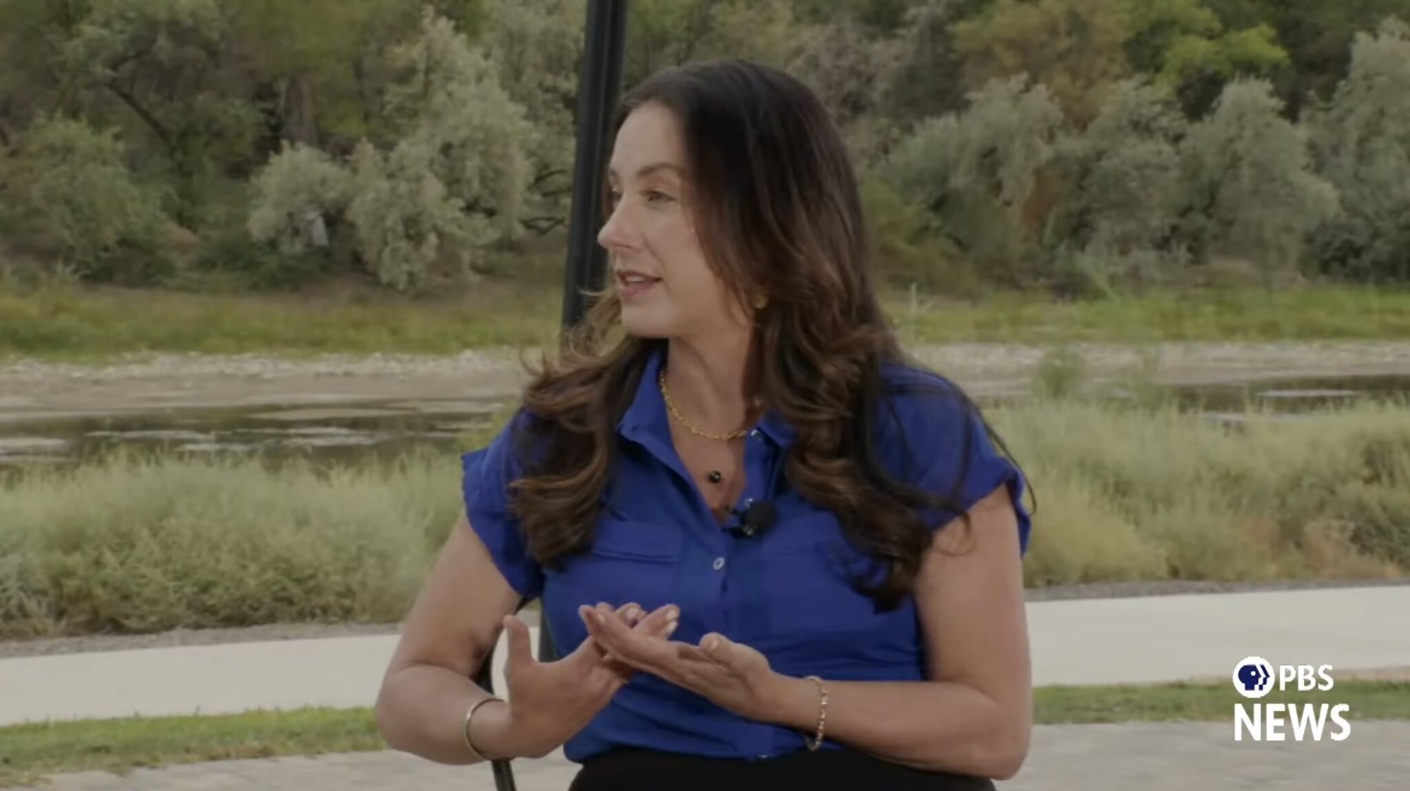
Becky Mitchell, Colorado member of the Upper Colorado River Commission, speaks to PBS News about the fight for Colorado River water near the banks of the river in Grand Junction on Aug. 19, 2026. (Screenshot via YouTube/PBS News)
The future of the Colorado River is looking bleak, and officials in the seven states that depend on its water say they’re happy to negotiate — but with current use rules expiring at the end of the year, compromise seems unlikely.
During a more than two-hour PBS special on Wednesday, officials from the Upper and Lower basins, as well as farmers and water experts, painted an alarming picture of a shrinking river without enough water to meet legal allocation obligations set more than 100 years ago.
The Colorado River is a vital source of drinking water for 40 million people in the seven states, Mexico and 30 Native American tribes, and it provides water for farming operations and hydroelectricity.
The Lower Basin states — Arizona, Nevada and California — and the Upper Basin states — Colorado, New Mexico, Utah, and Wyoming — have been attempting to negotiate an updated water usage agreement for more than two years. So far, they’ve been unsuccessful.
Because of the negotiating impasse, the federal government has devised a plan to replace the agreement that expires at the end of the year. It will impose drastic cuts on the Lower Basin states, and Arizona will feel the brunt of those cuts with a cut to its river water of up to 77%.
Arizona faces an outsized burden when it comes to reductions because the Central Arizona Project, a series of canals that supplies Colorado River water to the metropolitan Phoenix and Tucson areas, is one of the newest users of the river water, making it legally one of the first to be cut.
The major sticking point in the negotiations is the Upper Basin states’ refusal to commit to any mandatory cuts, while the Lower Basin states already take cuts in dry years.
Becky Mitchell, Colorado’s water commissioner, said that her state already deals with mandatory cuts, they’re just from Mother Nature, not the U.S. government. The Colorado River is fed by melting snowpack in the Rocky Mountains, which is at a record low this year.
“What I can’t promise is to deliver water when it’s not there,” Mitchell said. “Nobody can.”
She characterized the Lower Basin states’ argument that the Upper Basin wasn’t taking mandatory cuts as a “major flaw,” since the Upper Basin uses anywhere between three to five millions acre-feet per year, based on what’s available.
An acre-foot of water is enough to cover an acre of land to a depth of one foot, or about 325,851 gallons. That’s enough to provide three homes in Arizona a year of water, on average.
Mitchell said the cuts from Mother Nature are “far more fierce than the federal government will ever be,” putting farmers on the western slope of the Rockies at risk of going out of business.
And while those in the Upper Basin balk at the swimming pools and golf courses in the middle of the desert that are prevalent in urban centers of Arizona and Nevada, municipalities account for only about 25% of the Lower Basin’s water use.
Agriculture accounts for the other 75%. Andrea Travnik, assistant secretary for water and science at the U.S. Department of Interior, dodged a question from PBS about whether the federal government would contemplate putting restrictions on water use for farming, which would be incredibly politically unpopular.
Travnik said that the federal government has already worked with the states to raise water levels in Lake Mead through conservation efforts, and will continue to push for conservation, in addition to other solutions like desalination — which is extremely expensive — and water reuse.
But Brad Udall, a water and climate scientist at Colorado State University, said that if the 1,500 farmers that depend on Colorado River water for their crops are pitted against the 5 million people in metropolitan Phoenix and the 18 million people in the greater Los Angeles area, the winner will be obvious.
Udall thinks the states need to ditch the outdated 1922 Colorado River Compact, which allocated 7.5 million acre-feet for each basin, and was based on a faulty model that assumed the river system could supply 15 million acre-feet annually. While use agreements have been updated numerous times since then, the allocations to each basin remain the same.
Udall/Overpeck 4-panel Figure Colorado River temperature/precipitation/natural flows with trend. Lake Mead and Lake Powell storage. Updated through Water Year 2025. Note the tiny points on the annual data so that you can flyspeck the individual years. Credit: Brad Udall
The region is in the midst of a 20-year mega drought that is wreaking havoc on the river. Since 2000, flows in the Colorado River have decreased by 20%. And since, 2020 flows are down 35%.
After negotiations with the Upper Basin were unfruitful earlier this year, the Lower Basin states in May offered their own proposal to reduce their shared usage by 1.25 million acre-feet annually in 2027 and 2028, with about a 30% cut for Arizona.
This proposal was aimed at helping to stabilize water levels in Lake Powell and Lake Mead, the system’s two key reservoirs, whose water levels fell this month to their lowest point since 1957.
Udall described both reservoirs as just above deadpool, the point at which water drops too low to flow past a dam by gravity.
“Deadpool is a point where you lose control of the reservoir,” he said. “Mother Nature controls what happens. It controls what comes in. It controls what you send out the bottom.”
Reaching deadpool would turn those reservoirs into nothing more than concrete basins where water evaporates, Udall said.
“It’s kind of hard to overstate the consequences of losing those water bank accounts for the states that rely on it in the Lower Basin,” he said.
While Mitchell said that the Upper Basin couldn’t guarantee its 7.5 million acre-feet delivery of water to the Lower Basin, it would attempt to prevent the reservoirs from reaching deadpool.
Tom Buschatzke, director of the Arizona Department of Water Resources, said that the basins could come to an agreement today, if the Upper Basin would agree to take a 2% mandatory cut of its annual available water supply, or about 100,000 acre-feet in a year with 5 million acre feet available.
Mitchell did not say she would agree to those cuts, saying that the Upper Basin states are already managing their water responsibly.
But Arizona and the other Lower Basin states have undertaken significant conservation efforts for Colorado River water since 2014 and have reduced their consumption from 7.4 million acre-feet in 2015 to just over 6 million in 2024, adding 165 feet of water to Lake Mead.
All of the water officials who participated in the PBS special said they would prefer to hammer out a compromise instead of going to court, but that they were committed to protecting their water rights.
In March, Arizona retained the high-powered law firm Sullivan & Cromwell to represent the state in possible litigation among the Colorado River Basin states and the federal government.
Kathryn Sorensen, director of research at the Kyl Center for Water Policy at Arizona State University, said that while the fight for Colorado River water has become “existential” because of overallocation, Arizonans shouldn’t panic yet.
Even if the Central Arizona Project goes dry, she said, Phoenix still has banked groundwater and the Salt and Verde rivers to fall back on. Sorensen said she doesn’t expect municipal water shortages, but she does predict higher water bills.
The Trump administration’s draft “preferred alternative” plan for the river, released last month, could reduce the Lower Basin’s allocation by 3 million acre-feet per year, slashing Arizona’s water supply from the river by more than 75%. But there’s still a possibility that the federal government could implement the Lower Basin’s proposal for smaller cuts instead.
The federal government’s new river usage rules, which are still being negotiated, will be released later this year.
Udall said that the U.S. is totally failing to address the overall cause of the river’s decline.
“There’s a whole bunch of scientific studies that suggest that this is very much human-caused,” Udall said. “It’s due to our greenhouse gas emissions and the warming of the earth right now.”
This story was originally produced by Arizona Mirror, which is part of States Newsroom, a nonprofit news network which includes Colorado Newsline, and is supported by grants and a coalition of donors as a 501c(3) public charity.
Colorado Newsline is part of States Newsroom, a nonprofit news network supported by grants and a coalition of donors as a 501c(3) public charity. Colorado Newsline maintains editorial independence. Contact Editor Quentin Young for questions: info@coloradonewsline.com.
For Mead and Powell, fresh record lows. Data: USBR; Graph: Jack Schmidt
Click the link to read the article on the InkStain website (Jack Schmidt and John Fleck):
August 7, 2026
When Lake Mead’s elevation crossed the threshold of 1,040 feet above sea level in the spring of 1937, stretching upstream 100 miles behind Hoover Dam in the deserts of the Arizona Nevada border, it was national news.
So much water!
Kerrville Times, Kerrville Texas, May 13, 1937
As Mead drops past that threshold in the opposite direction in the summer of 2026, it’s telling a different story. So little water.
Two milestones in the last few days are worthy of note. The first is Lake Mead itself, which in the last two days dropped past the previous lowest levels in history set in 2022, meaning it is now the lowest it has been since the reservoir was first filled in the 1930s.
Lake Mead was at 7.012 maf yesterday (Aug. 6, 2026) (1040.5 ft). The previous record low was 7.018 maf (1040.58 ft) that was set on July 28, 2022. Thus, yesterday’s reservoir contents in Lake Mead are the lowest since at least May 1937.
Meanwhile, Lake Powell is now 85,000 af (1.51 ft) above its lowest historical amount since it was first filled in the 1960s.
But that does not fully capture the extent of the crisis. Total reservoir contents of all 46 reservoirs in the Reclamation data base (extending from Fontenelle and Grand Lakes to Lake Havasu) was at 21.27 maf on July 1, the lowest since at least May 29, 1965 (probably earlier, since the Reclamation data base doesn’t report many reservoir contents at that early date).
The vultures didn’t wait long to feed on the carrion of shrunken national monuments. Within days of President Donald Trump’s order slashing nearly 3 million acres from Bears Ears and Grand Staircase-Escalante National Monuments, mining claims were filed within the former boundaries of both monuments with San Juan County and Kane County, respectively.
While Trump’s shrinkage did reopen that land to new mining claims and mineral leasing, it does not go into effect until Sept. 11, 60 days after the proclamations were issued. The claims have not officially been recorded with the Bureau of Land Management.
On July 14, Kimmerle Mining LLC out of Moab filed seven claims just within the eastern border of what had been Bears Ears National Monument just two days earlier. A few weeks later, Charles Rosequist filed two claims in the southwest corner of the GSENM, near Kaibab Gulch and the Vermilion Cliffs.
Kimmerle Mining, its principal Kyle Kimmerle, and other family members hold dozens of mining claims across southern Utah and western Colorado uranium country. The family firm became known for staking claims in what would become Bears Ears National Monument leading up to its designation, and for locating more after Trump’s first national monument shrinkage in 2017.
Just before Biden restored the boundaries in 2021, Kimmerle Mining staked five new claims within the national monument and acquired additional claims from another firm in the historic White Canyon mining district. Kimmerle Mining promptly filed for a permit to do exploration work there, but the BLM said they had to demonstrate the claims’ “validity,” or show that they contained “valuable minerals.” The process for doing so would cost up to $100,000. Shortly thereafter, Kimmerle joined the state of Utah’s lawsuit seeking to eviscerate the national monument, claiming that its establishment had caused him to lose out on mining profits.
And, in 2018, the Kimmerle family staked the Easy Peasy claims in the Cottonwood Wash drainage in what had been Bears Ears National Monument. The new claims are adjacent to those, in the Cheese & Raisins Hills area, which was mined historically for vanadium and uranium. The Shumway brothers staked claims there back in the 1930s, including the Big Hole Mine, and the ruins of an old vanadium mill are still visible nearby.
Remnants of a historic vanadium processing plant in the Cottonwood Wash drainage near where Kimmerle Mining filed seven mining claims in an area removed from Bears Ears National Monument. Jonathan P. Thompson photo
Whether the firm plans to mine the claims, or is just looking for more grounds for a future lawsuit in the event that the next administration restores the boundaries isn’t clear. They have been known to use mining claims to make political points: Late last year, Kimmerle Mining staked four 20.66-acre lode claims on the east slope of the Henry Mountains, naming them Trump I, Trump 2, Trump 3, and Trump 4.
Also in the shady mining moves around national monument shrinkage: Less than a week before Trump issued the proclamations, Energy Fuels CEO Ross Bhappu purchased 74,000 shares of the uranium mining and milling firm’s stock, and the company’s chairman Bruce Hansen bought 4,000 shares. Democratic lawmakers on the House Natural Resources committee are now investigating the trade and the possibility that the executives received privileged, non-public information from the Trump administration in advance of the shrinkage.
Energy Fuels owns and operates the White Mesa uranium mill in San Juan County, Utah, east of Bears Ears National Monument. The company lobbied the Obama administration prior to its original 2016 designation. Though the administration ultimately excluded Energy Fuels’ Daneros mine from the monument, the firm lamented the fact that seven miles of the mine’s one access road still fell within the boundaries.
In 2017 Energy Fuels lobbyists, including former U.S. Rep. Mary Bono, R-Calif., met with Trump administration officials, and requested that it “reduce the size of the (Bears Ears National Monument) to only those specific resource areas or sites, if any, deemed to need additional protection beyond what is already available to Federal land management agencies.”
In 2021, IsoEnergy acquired the Daneros Mine and other mining properties from Energy Fuels. But any ore mined in the former Bears Ears is likely to be processed at Energy Fuels’ White Mesa mill, so they stand to benefit from the shrinkage.
⛈️ Wacky Weather Watch⚡️
It wasn’t exactly a hurricane that hit Hurricane, but it was pretty darned destructive. This past weekend a huge storm pounded southwestern Utah, leading to arroyo-busting flash floods that turned the city’s streets into rivers of mud. The water gave a big boost to the Virgin River, which shot up from about 165 cubic feet per second to over 4,000 cfs in a matter of hours.
🐟 Colorado River Chronicles 💧
Lake Powell reached a grim benchmark this past weekend, when its surface elevation dropped to its lowest level since 1968, when the nation’s second largest reservoir was still filling up. In April of 2023, the level fell to 3,519.92 feet. On August 15 of this year, it reached 3,519.91 feet and is still falling at a rate of about two inches per day.
While not exactly surprising, the event launched many a news story in the mainstream media. And as is often the case with complicated issues like these — and the Glen Canyon Dam problem is not exactly simple or straightforward — some of the facts in these stories can be a little less than factual, and could use a bit of clarification.
The graphic showing reservoir levels at Lake Powell says that at 3,370 feet, known as dead pool, “Water no longer flows past the dam.” As Zak Podmore — who wrote the book on Lake Powell and deadpool — pointed out on X-Twitter, that is not quite right. What actually would happen is that the dam would become a run-of-the-river facility, meaning water released from the dam would be equal to water flowing into the reservoir (minus losses from seepage and evaporation). So the Grand Canyon would not go completely dry, though there would be times when flows are pretty darned low.
The piece notes: “About 6 million people across the Southwest rely on electricity from the dams [both Glen Canyon and Hoover].” This isn’t wrong, it’s just worded in a way that overstates the importance of these generators’ energy output to the Western power grid. Combined, the dams produce enough electricity annually to power some 550,000 households for a year. That power is sold at cost to municipalities, cooperatives, tribal nations, irrigation districts, and utilities across the West, which include it as part of their larger portfolios. The 6 million figure probably refers to all of the customers all of those entities serve; if the dams go down, these folks most likely wouldn’t notice except for a small jump in their power bills.
Humpback chub. National Park Service illustration by Joe Tomelleri.
Protect the Grand Canyon’s Humpback Chub A guest dispatch by Ron Rudolph
This month Lake Powell will shrink to a level last seen in 1968, a few months before the first astronauts orbited the Moon. The receding reservoir has forced the Bureau of Reclamation to abandon the practice of releasing cool water from the reservoir, a strategy used successfully to prevent smallmouth bass from becoming entrenched in Grand Canyon National Park below Glen Canyon Dam.1 The bass are an invasive species that can escape from Lake Powell and could imperil the Grand Canyon’s native humpback chub population, the most important remnant of a federally protected species that was once widespread throughout the Colorado River system.2 Scientists attribute steep declines in the humpback chub population in the upper Colorado River Basin largely to smallmouth bass predation.3
Sustaining the humpback chub population in the Grand Canyon is essential to prevent the species’ extinction. With cool water releases no longer feasible, protecting the humpback chub now requires a different approach. Increasing the delivery of sediment into the Grand Canyon may be the most effective remaining tool. Additional sediment transported from Lake Powell, either around or through Glen Canyon Dam, would increase turbidity, making it more difficult for smallmouth bass to establish a stable population.
The Bureau’s decision to halt cool water releases reflects the severity of the ongoing drought, which has reduced this year’s unregulated flow of the Colorado River to the second lowest since Glen Canyon Dam was completed 63 years ago.4 In April, the agency instituted unprecedented efforts to bolster Lake Powell, which were intended to preserve Glen Canyon Dam’s ability to generate hydropower.5 Despite those efforts, the Bureau’s July 24-month forecast of the minimum probable flow of water into Lake Powell anticipates Glen Canyon Dam will be unable to generate electricity from February 2027 through at least June 2028.6 In fiscal year 2025, Glen Canyon Dam generated enough electricity to supply the annual average needs of 269,000 U.S. households.7
Humpback chub evolved exclusively in the Colorado River system, the water often referred to as “too thick to drink and too thin to plow.” It developed exquisite adaptations to thrive in a volatile environment, driven by flash floods that can rapidly turn relatively clear water to an opaque reddish-brown, making it impossible to see one’s finger one inch below the surface. Its gills and mouth have protective flaps that prevent sediment from clogging them, its eyes are tailored to see in muddy water, and special sensory organs detect prey and plants, allowing the fish to breathe and eat in highly turbid conditions. In contrast, smallmouth bass evolved in clear lakes and streams, relying on their vision to obtain food.
Fortunately, the adult humpback chub population is flourishing in the western Grand Canyon where sediment from the annual monsoon season turns the river into a torrent of mud. From 2010 to 2024, the population grew about 160-fold, with the median population estimated at about 70,000.8 This resurgence caused the U.S. Fish and Wildlife Service to reclassify the species from being endangered — i.e., in imminent threat of extinction, under the Endangered Species Act — to a less serious status of threatened.9
Smallmouth bass were not present in the Grand Canyon prior to the construction of Glen Canyon Dam, but now occur occasionally in its western section. The largest smallmouth bass captured in the park – 15.2 inches – was found in the far western section of the Grand Canyon in 2006.10 The fact that humpback chub flourish in the western Grand Canyon while smallmouth bass do not underscores the importance of intense and sustained pulses of turbidity created by suspended particulates. These conditions appear to be a key factor in preventing smallmouth bass from becoming established.
Because Glen Canyon Dam traps most sediment before it can reach the Grand Canyon, the Bureau should commission a study to evaluate options for increasing sediment delivery from Lake Powell. A sediment bypass system, such as a pipeline around or through the dam, could provide the turbidity needed to suppress smallmouth bass in the absence of cool water releases. Given current hydrologic realities, such an approach may be the most effective long‑term strategy for protecting the humpback chub and preserving the ecological integrity of the Grand Canyon.
1 “Feds Nix Grand Canyon fish protection flows below Lake Powell,” Arizona Republic, August 7, 2026
2 Glen Canyon Adaptive Management Program — https://gcdamp.com/index.php/ Smallmouth_Bass_Page
3 U.S. Geological Survey, “Dropping the Bass: USGS science helps partners stop spread of invasive smallmouth bass in the Colorado River,” March 21, 2025
4 The Bureau of Reclamation’s July 2026 “Most Probable” 24-Month Study projects unregulated inflow for this water year at 3.501 million acre-feet. 2002 is the driest on record at 2.64 MAF
6 Bureau of Reclamation, July 2026 Probable Minimum 24-Month Study; https://www.usbr.gov/ lc/region/g4000/24mo_MIN.pdf. When Lake Powell drops below elevation 3,490, it can no longer generate hydropower. See Bureau of Reclamation, Final Environmental Impact Statement, Post-2026 Operational Guidelines and Strategies for Lake Powell and Lake Mead, Technical Appendix 15, Dams and Electrical Power Resources, page 15-11
7 In Fiscal Year 2025 Glen Canyon Dam generated 2,792,000,000 kilowatt-hours of electricity, according to the Western Area Power Administration’s Statistical Index — https:// http://www.wapa.gov/wp-content/uploads/2026/06/FY-2025-Statistical-Appendix.pdf, page 9. According to the U.S., Energy Information Administration, U.S. households use an average of 10,365 kWh annually. https://www.eia.gov/tools/faqs/faq.php?id=97&t=3; avg monthly consumption 863; annual 10,365 kWh EIA https://www.eia.gov/electricity/ sales_revenue_price/pdf/table_5a.pdf
8 Dzul et al., “Integrating mark-recapture, catch, and expert habitat assessments to quantify recent increases in humpback chub abundance over a 200 km long river segment of the Colorado River in western Grand Canyon,” Canadian Journal of Fisheries and Aquatic Sciences, July 2026. Dzul estimated with 95% confidence that the population was between 40,000–200,000
Army Corps approves a permit for the Line 5 oil pipeline tunnel just as a state permit is invalidated.
NOAA finds that July was the warmest month in the country’s 132-year historical record.
U.S. Fish and Wildlife Service takes comments on draining farmland near protected prairie wetlands.
Two Senate Democrats introduce water system cybersecurity bill.
USGS reports on long-term changes in U.S. groundwater and surface water.
And lastly, the two big Colorado River reservoirs drop to all-time lows as the federal government prepares a new two-year operating plan.
“What can we do if the administration isn’t willing to allow us to use the [Glen Canyon Dam] bypass tubes for high-flow experiments, if that’s going to be off the table, at least for a while?” – Wayne Pullan, Upper Colorado regional director at the Bureau of Reclamation, discussing Trump administration constraints on using Glen Canyon Dam to assist threatened fish in the Grand Canyon and rebuild eroded beaches along that stretch of the Colorado River. Earlier this month, Reclamation decided against a short-term release of cold water from deeper in Lake Powell to disrupt non-native fish spawning because the release would have reduced hydropower generation. “We’re in a pinch point,” Pullan added. “A real pinch point.”
News Briefs
Line 5 Decision The Army Corps of Engineers approved a permit for Enbridge to build a tunnel beneath the Straits of Mackinac, a waterway that connects Lake Michigan to Lake Huron. The tunnel would house a new Line 5 oil pipeline.
The federal agency’s decision is not the final word. State permits for the tunnel are being litigated and reversed. On July 31, the Michigan Supreme Court invalidated a state Public Service Commission approval because the commission did not properly assess project impacts or need.
Cybersecurity Bill Some two weeks after Iranian hackers allegedly targeted U.S. water utilities, two Senate Democrats introduced a bill to bolster water system cybersecurity.
The Water Cyber Shield Act focuses on risk reduction. It requires water systems to assess their cybersecurity risks, develop a response plan, and submit them for state approval. The submitted information is exempt from FOIA.
The bill also requires the EPA to establish baseline cybersecurity standards that impose more burdens on higher risk water systems. It authorizes $300 million annually over five years to help drinking water systems identify and fix vulnerabilities, as well as $300 million annually for wastewater systems.
According to NOAA data, it was the hottest single month since record-keeping began at the end of the Gilded Age, in 1895.
The average temperature for those 31 days was 76.9 F, which was 3.3 F above the 20th century average. It was especially warm in the Intermountain West, where states are also observing record-low river flows. [ed.emphasis mine]
Water Trends The West and the High Plains are drying while the Upper Midwest and Northeast are getting wetter.
That is the broad pattern identified in a U.S. Geological Survey evaluation of large-scale groundwater and surface water changes between 1980 and 2020.
On the Radar
Colorado River’s Shrinking Reservoirs Both Lake Mead and Lake Powell now sit at their lowest levels since the manmade reservoirs were first filled.
The record-breaking plunge underscores the precarity of water supplies in the Colorado River basin. Because this year’s mountain snowpack has already melted, the reservoirs will likely set new lows through at least next April.
Lake Mead key elevations. Credit: USBR
Lake Mead is at 1,039 feet, four feet above the level at which hydropower generating capacity at Hoover Dam will drop by 70 percent.
Lake Powell rests at 3,519 feet. The Bureau of Reclamation is attempting to keep the reservoir above 3,500 feet to protect Glen Canyon Dam’s water supply and power-generating infrastructure.
Draining, or Not Draining, Prairie Wetlands The U.S. Fish and Wildlife Service took comments on the process for draining waterlogged lands for farming in an important duck habitat in the northern plains where the government holds wetlands easements.
Formed by retreating glaciers, prairie potholes are shallow ponds in Iowa, Minnesota, Montana, North Dakota, and South Dakota that sustain most of North America’s waterfowl. To protect the habitat, the FWS began buying easements from farmers in 1959. Those easements prohibit draining the wetlands.
To grow crops on sodden land, farmers install drain tile – perforated pipes placed underground. Farmers whose land contains an easement can request the FWS calculate a distance beyond the wetlands where drain tile can be installed.
The agency wants to know how it should make those calculations.
Prairie-Pothole Region of North Dakota. Photo Credit: U.S. Fish and Wildlife Service
This past week, the U.S. Bureau of Reclamation posted an attention-grabbing statistic. By dropping to less than 25% of its capacity, Blue Mesa Reservoir has lost its status as the state’s largest body of water. Lake Granby, itself just 62% full, now holds the title.
Recent best seller set in Iola and the West Fork of the Gunnison River. Click the image to read about it.
The ruins of Iola, a community flooded in the creation of Blue Mesa, are now visible. Parts of the Gunnison River snake through the lakebed in imitation of its historic path before the reservoir was dammed in the 1960s.
In a different year, the water storage unit that includes Blue Mesa might have helped replenish Lake Powell, the second-largest reservoir in the U.S., which now sits worryingly close to power pool. Power pool is the threshold when water levels drop too low to produce hydroelectric power…There’s no chance of Blue Mesa contributing much to Lake Powell this year, said Steve Pope, manager of the Uncompahgre Valley Water Users Association…The Uncompahgre Valley Water Users Association relies on water stored in the Blue Mesa, which is diverted downstream through the Gunnison Tunnel to irrigate tens of thousands of acres of farmland. The communities of Montrose, Delta and Olathe also rely on raw water from the tunnel for municipal use. The association typically has a secondary water supply from the Uncompahgre River, but Pope said that source is “nonexistent” this year. In anticipation of shortages, the association already limited users to 50% of their allocations this spring. Pope said he hoped no further restrictions would be necessary before Labor Day. Large row crop producers have already fallowed 30%-60% of their land in the valley, he said…
The Bureau of Reclamation has taken steps to avoid that scenario, said Caleb Foy, senior water resources engineer at the Colorado River Water Conservation District. Water managers were already anticipating a historically dry year this spring, when the window for the mountains to accumulate snowpack passed leaving the lowest amount ever recorded. Snowpack melts in spring to produce runoff, which feeds the Colorado River Basin. If the Bureau of Reclamation and water rights holders along the Gunnison River had not put restrictions in place, Blue Mesa might have been on a trajectory to drain past power pool, Foy said. The reservoir’s generators have an 86.4-megawatt capacity, enough to generate power for about 3,400 homes.
Climate change will almost certainly feature prominently in any multi-state litigation over the Colorado River. A court case over an almost-finished dam expansion may decide how.
Is climate change enough justification to stop the expansion of a reservoir that will take more water from the dwindling Colorado River?
That’s the central question in a lawsuit pitting the U.S. Army Corps of Engineers and Colorado’s largest water utility against a consortium of environmental nonprofits. The environmentalists say the Colorado River has no more water to give, while Denver Water, the utility whose Gross Reservoir would nearly triple in capacity, argues it is ensuring its customers can withstand droughts. The Corps contends it is not required to consider climate change or the downstream effects of its expansion of a dam to grow the reservoir.
The case in the 10th U.S. Circuit Court of Appeals has the potential to ripple through Western water management as states, tribes, cities and the federal government struggle to find a compromise on how to steeply cut water use. Some see history repeating itself, with the Gross Dam expansion emblematic of the kind of thinking that helped put the West into the very water crisis the project is meant to buffer the region against.
“Does it make sense for major water projects like this to continue to move forward?” asked Sarah Matsumoto, an associate professor of clinical law at the University of Colorado, Boulder, and director of the Getches-Green Natural Resources, Energy, and Environmental Law Clinic. “I just don’t think it does anymore, without at minimum considering impacts of climate and impacts of overappropriation on the river.”
The Corps and Denver Water appealed that decision, arguing that construction of the dam expansion is nearly complete, and topping off the reservoir behind it is in the public’s best interest. There are no other alternatives to consider, the utility asserts. The National Environmental Policy Act (NEPA), which requires evaluating the impacts of projects that need federal approval, does not require the assessment of climate change, they contend.
“We believe that considering potential climate impacts to a project goes beyond the scope of any guidelines, practicability, or NEPA reasonableness analysis,” said U.S. Department of Justice attorney Kyle Glynn, representing the Army Corps, during oral arguments for the case before the 10th Circuit Court of Appeals.
The expansion of Denver Water’s Gross Reservoir would hold an additional 77,000 acre feet of water diverted from the declining Colorado River, enough water for roughly 150,000 homes. Denver Water would get that water incrementally from an unused 1945 water right of 18,000 annual acre feet to ensure it can supply the growing metropolis of Denver and protect its water supplies during droughts.
The utility plans to only use its water right during wet years when it can stockpile water from excess supply. Of the 77,000 acre feet in diversions, 5,000 would be sequestered in an “environmental pool” that would enhance streamflows on South Boulder Creek and serve as additional storage for the cities of Boulder and Lafayette.
But environmentalists are not convinced there will be enough surplus water in the future for the utility to fill the reservoir. If the state is required to cut back its water use to address system-wide shortages on the Colorado River, reductions the seven states that depend on the river are currently negotiating, what happens to the over $800 million project, they wonder.
Those are the concerns driving the environmental groups, which sued over what they called an inadequate NEPA process and a failure to properly examine alternatives to the project. Natural resource professors watching the case share their concerns. The court’s decision, both say, could have far-reaching consequences for Southwestern states and nearly 40 million people who rely on the Colorado River, and could determine how climate change is considered in any future litigation.
Denver Water’s position is in direct contradiction with what Colorado is arguing in the current negotiations about how much water from the river states must give up, said Gary Wockner, founder of Save the Colorado, the environmental group that’s led the push against the Gross Reservoir expansion.
Colorado has maintained that it and other states close to the river’s headwaters should not have to make mandatory cuts because climate change is already limiting their supply by reducing river and stream flows. Should the negotiations over cuts to allocations from the river devolve so completely that states in the upper and lower halves of the Colorado River Basin sue one another, some water law experts believe climate change would figure prominently in the litigation.
“If the court supports Denver Water and says that Denver Water did not have to account for climate change to prove that they could operate the project, it sets a very difficult and perhaps powerful precedent, potentially undermining the state of Colorado’s position in the entire Colorado River negotiations,” Wockner said.
Roller-compacted concrete will be placed on top of the existing dam to raise it to a new height of 471 feet. A total of 118 new steps will make up the new dam. Image credit: Denver Water.
Can a Dam’s Progress Block Climate Considerations?
On the last day of July, attorneys for the environmental groups, Denver Water and U.S. Army Corps of Engineers gathered before three justices on the 10th Circuit Court of Appeals in a courtroom in Santa Fe, New Mexico. Their oral arguments came nearly two years after senior federal judge Christine Arguello ruled in favor of the environmentalists, saying that “the cracked foundation of the Colorado River’s management system all but demands skepticism over any proposal that will affect the hydrology of the Colorado River basin.”
Arguello’s decision didn’t stop construction to expand the dam, but forced the parties to meet and agree on remedies. Those discussions failed, however, leading Arguello to issue an injunction to stop construction in April 2025. That was lifted due to safety concerns about the dam being left incomplete, but an injunction remained preventing the clearing of the forest below to make room for the additional water, or filling the added space behind the dam.
The Gross Reservoir expansion solves a problem Denver Water has been trying to address for 23 years, said Jessica Brody, general counsel for the utility, in the 10th Circuit last month.
Denver Water has a water storage imbalance between its two collection systems with 90% of its reservoir storage located in the utility’s South System compared to 10% in its North System. This storage imbalance creates vulnerability if there is a drought, mechanical issue or emergency that affects the South System. The storage imbalance is one of the reasons Denver Water is expanding Gross Reservoir. Image credit: Denver Water.
Denver Water’s storage and delivery network is divided into north and south systems, which are unconnected and imbalanced. The south system provides 80 percent of the utility’s water supply, and if it were to go down, the north system, which includes Gross Reservoir, could run out of water in just one year. That leaves the utility’s system vulnerable in times of severe drought, wildfires or other emergencies.
Despite construction being nearly done, Brody said, Denver Water has a dam it cannot fill because of the lower court’s opinion.
That decision was an “abuse” of the court’s power, she said, as the water rights at stake are under the jurisdiction of the state, not federal agencies. Plaintiffs never sought a preliminary injunction to stop construction, although they did when later mediation failed. Jurisdiction over the cutting of trees to make room for the expanded reservoir lies with the U.S. Forest Service and the Federal Energy Regulatory Commission, not the Corps, she said.
The arguments from Denver Water and the Corps seemed to resonate with the three justices presiding over the case, largely due to the fact the dam is nearly complete.
“Poor pun: It’s water over the dam, because it’s built,” said Judge Timothy Tymkovich. “So costs, and I think climate change, are off the table now.”
William Eubanks, the attorney representing the environmental groups, disagreed. The dam expansion is part of Denver Water’s Moffat Collection System project, which requires work in addition to the Gross Reservoir project, such as felling the trees.
And there is still the question of where the water will come from.
A central point for the lawsuit, he said, is that under the Clean Water Act, water infrastructure developers have to show a project can be built and fulfill the expected need—in this case, a reservoir with more water. That wasn’t done here, Eubanks said.
“With the Moffat Collection System project, Denver Water and the Army Corps have recklessly gambled with over $800 million of ratepayer money,” Eubanks said before the court. Neither the Corps nor the utility forecasted whether there would be enough surplus water in the Colorado River for Denver Water to fill its reservoir, he argued. “In effect, they’re building a giant bathtub, even though there’s likely no water to ever fill it.”
CU Boulder professor Matsumoto is one of 11 natural resource law experts who submitted an amicus brief to the court asking it to affirm the lower court’s decision.
This case, they wrote, is a “classic example of why we need NEPA”—illustrating the consequences of an agency permitting and approving a project without a full evaluation of other alternatives and whether the project was even feasible. The foundational U.S. environmental law was designed to push agencies to “fully appreciate the consequences of their actions before they move forward with those actions,” they wrote.
The Corps violated NEPA by limiting the number of alternatives it considered for the project and only examining impacts up to 50 miles downstream, not along the full course of the river, the brief noted.
“It just doesn’t make any sense for the amount of water that they’re getting,” said Mark Squillace, a natural resources law professor at the University of Colorado in Boulder, and another one of the professors part of the amicus brief. “It’s insane.”
Udall/Overpeck 4-panel Figure Colorado River temperature/precipitation/natural flows with trend. Lake Mead and Lake Powell storage. Updated through Water Year 2025. Note the tiny points on the annual data so that you can flyspeck the individual years. Credit: Brad Udall
A Complicating Compact
Since 1922, the Colorado River has been governed by its eponymous compact, which is now widely acknowledged to have overallocated the river by millions of acre feet of water. Under the compact, both the Upper Colorado River Basin, made up of Colorado, New Mexico, Utah and Wyoming, and the Lower Basin states of Arizona, California and Nevada, are entitled to 7.5 million acre feet of water, with another 1.5 million acre feet going to Mexico. But the river has averaged closer to 11 million acre feet since 2020—more than 6 million acre feet less than the total that has been allocated, according to the most recent federal data.
Though both basins get an equal share of the river, Article III(d) of the compact specifies that the Upper Basin “will not cause the flow of the river” to be depleted below an average of 7.5 million acre feet per year over any 10-year period downstream.
Failing to meet that requirement could trigger the Lower Basin to demand more water from the Upper Basin in what is known as a “compact call.” That unprecedented action could force severe water usage curtailments in the Upper Basin, and how that would affect users like Denver Water is unclear. The system is dangerously close to the hydrological conditions that could trigger a compact call.
It’s a known risk for this project, the professors say, but one that was ignored during permitting.
Gross Reservoir is far from the only new diversion proposed in the Upper Basin, which has never used its full allocation from the river, but sees that water as key to the region’s continued economic growth and prosperity. Over 1 million acre feet of diversions have been proposed across 30 projects in the Upper Basin. Many of those may not be developed, but they have become a sticking point in negotiations over the river’s future.
“Repeating the Same Mistakes”
As the lawyers argued in Santa Fe, news of a short-term federal proposalfor managing the Colorado River rippled across the basin. In the absence of a new consensus among the states over how to allocate the water, the federal government stepped in to manage the crisis.
Its track record on the Colorado River is deeply checkered.
The compact has served as the bedrock for a web of dams, reservoirs, canals and ditches built largely with federal funding and engineering prowess to distribute water across arid Western lands. The magnitude of this diffuse system and its overreliance on diverting and impounding water, experts say, is at least partially responsible for the severity of the West’s water crisis.
Building the Gross Reservoir Dam in the 1950s. Photo credit: Denver Water.
Some believed not everyone has learned the lesson. “We’re just repeating the same mistakes,” Squillace said. “A lot of it just results from a lack of imagination about a better way to do things.”
As water supplies shift, water utilities across the West are squeezing every last drop out of their systems through a range of modifications and adjustments to their infrastructure.
After the first of the West’s deep 21st-century droughts in 2002, Denver Water, which serves 1.5 million people across Colorado’s Front Range, decided it needed to act. The utility convinced the Army Corps of Engineers, which completed the original Gross Reservoir in the 1950s, that raising the dam to triple the amount of water it could impound would be the best course of action to combat drought.
Since then, Denver Water has also invested in water efficiency, which allowed it to better endure droughts from 2002 to 2026. Despite a growing population, water use is below the benchmarks from the 1970s, said Jeff Martin, Denver Water’s program manager for the reservoir expansion.
“We’ve really capitalized on most of our customer savings at this point,” he said. “Now, we need to shore up the rest of our need with the expanded reservoir.”
But a drier future is precisely what should preclude Denver Water and the Corps from seeing this project through, said Wockner with Save the Colorado.
“It’s nonsensical to be diverting more water out of rivers anywhere in the Southwest United States,” he said. “Because in many ways the climate change bullseye in the United States is on the Southwest and Colorado River Basin.”
The Colorado River, Wockner said, has no more water to give. But Martin sees room for more improvement in how the river is managed.
“I would be the first to say something needs to change there on how we use the river for all stakeholders, including some type of cuts throughout the system,” said Martin. “I’m not that decision maker though.”
Graphic credit: RogerWendell.com
The state, he said, controls Denver Water’s rights to the river. The utility has the right to use the water that may one day fill Gross Reservoir, he said, and has been planning to do so for decades.
Despite arguments that the water isn’t available, Martin has no doubt Denver Water will be able to one day fill the reservoir—if the courts allow it.
What Comes Next
The justices have given no indication of when a ruling on the Gross Reservoir Expansion Project will land.
If Denver Water loses its current appeal, the utility claims it will be unable to ensure a reliable water supply during times of drought, and the decision may deter developers from pursuing other ambitious projects to solve the West’s water problems, from new dams to expensive desalination plants.
In the Santa Fe courtroom, Teagen Blakey sat on a wooden bench watching the lawyers argue over a project that has loomed over more years of her life than it hasn’t.
President of The Environmental Group, a nonprofit from Colorado’s Front Range and one of the lawsuit’s plaintiffs, Blakey grew up in the area around Gross Reservoir. She remembers sitting in community meetings as a teenager when the project was being permitted.
Despite the project’s impacts on Boulder County, the water won’t serve residents there, she pointed out. But the dam and reservoir expansions’ impacts will fall on the local population. At the site where Denver Water will clear the forest is a hike featuring a waterfall that would be submerged.
“It’s something you can’t quantify as a value,” she said.
With such a high cost to something so special, Blakey said, there must be certainty about the benefit it will provide.
South Platte River Basin via Wikipedia
Map of the Colorado River drainage basin, created using USGS data. By Shannon1 Creative Commons Attribution-Share Alike 4.0
Tensions about water management are high on the Colorado River, even as water levels in reservoirs like Lake Mead drop to record lows and the west faces severe drought conditions…On July 31, the federal Bureau of Reclamation released a final environmental impact statement which outlines a potential framework for management of the river between 2027 and 2036. This framework would include mandatory water use cuts of up to a combined 3 million acre-feet per year for the lower basin states of California, Nevada and Arizona while seeking 200,000 acre feet in voluntary reductions from the upper basin states of Colorado, New Mexico, Utah and Wyoming. The impact statement and the associated National Environmental Policy Act (NEPA) decision-making process still leave an opportunity for the states on the Colorado River to reach their own agreement about future water use…
Colorado is introducing a new near-term water contribution program designed to take advantage of federal funding to encourage voluntary, compensated reductions in Colorado River water use. At a webinar on Aug. 6, Amy Ostdiek, section chief for the Colorado Water Conservation Board (CWCB) interstate, federal and water information section, explained that this program is one of several parallel activities that the state is undertaking alongside the ongoing NEPA process. She explained that the Bureau of Reclamation has announced that $100 million in funding will be available to support the upper basin states in establishing water contribution programs that will provide “water that but for these actions would not be there” to the Colorado River. She noted that funding would likely support about two years of a program, based on previous project costs, and that, to participate and claim the funds, Colorado would need to act now to begin establishing a program. Ostdiek stated that establishing such a program would honor commitments the state has made in negotiations to making voluntary water use reductions and would show that “Colorado is committed to being part of the solution.”
Map of the San Juan River, a tributary of the Colorado River, in Arizona, Colorado, New Mexico and Utah, USA. Made using USGS National Map data. By Shannon1 – Own work, CC BY-SA 4.0, https://commons.wikimedia.org/w/index.php?curid=47456307
After years of analysis and stalled negotiations, the federal government last month finally laid out its proposal for managing the Colorado River’s biggest reservoirs for the next decade. The Bureau of Reclamation still needs to release its final decision and an operating plan for the next two years. But its final environmental impact statement provides a framework for how it intends to manage parts of the Colorado River system under its control…
It still might not be enough in a drying West
The Colorado River Basin has been mired in drought for more than two decades, and research shows that area will likely only get warmer and drier. The question that really matters is how the new plan operates in a dry world, said Jack Schmidt, senior research scientist at Utah State University’s Center for Colorado River Studies. The document gives Reclamation flexibility to respond to an uncertain, but likely drier, river basin. It doesn’t solve all issues, though. If drought conditions don’t improve, Reclamation said in its analysis that “even large and unprecedented reductions may be needed and may not be enough to stabilize storage” at Lake Powell and Lake Mead.
“The scary thing about all of this is that none of this solves the problem if the world keeps getting drier,” Schmidt said. “That should be taken as an enormous warning for the desperate need to reduce the impact of a warming planet and the drying of the Colorado River Basin.”
[…]
Reclamation’s framework sets a goal of 200,000 acre-feet of voluntary water conservation in Utah and other Upper Basin states — Colorado, New Mexico and Wyoming. Gene Shawcroft, Utah’s Colorado River negotiator, said it will likely take Utah and its upstream neighbors three to five years to conserve that amount.
The largest reservoir in Colorado, Blue Mesa, is holding just over 240,000 acre-feet — “roughly about a third of the volume that we would typically expect to see in the reservoir in this time of year,” says Caleb Foy, senior water resources engineer at the Colorado River District. April-through-July inflow, 151,000 acre-feet, is the lowest unregulated inflow on record. This time of year, Blue Mesa is operated to maintain a minimum flow at the Whitewater gauge, far downstream, just above where the Gunnison joins the Colorado. A 2012 federal record of decision sets base-flow targets there — as low as 750 cubic feet per second, though June and July normally call for “upwards of just over 1,000 CFS at 1,050 CFS,” Foy says. Those flows exist to protect biology and recreation in the lower Gunnison, and endangered fish in the 18-mile reach of the Colorado below the confluence. This summer the Bureau of Reclamation, in consultation with the US Fish and Wildlife Service, other Gunnison Basin water users and the State of Colorado, “decided and agreed to lower the whitewater target down to 500 CFS.” It “isn’t certainly done lightly” Foy says: the cut preserves “nearly 500 acre-feet of storage per day” buying time against a Bureau forecast that Blue Mesa could drop below minimum power pool as early as October. Below that elevation the dam’s 86.4-megawatt plant (enough energy to supply at least 34,000 homes at full pool) — stops generating, and Foy says electrical output is already falling. Unlike Glen Canyon Dam, he is “not aware of any concerns” about operating below power pool.
No, Lake Powell’s not that close to actual dead pool — or the level at which water can no longer be released downstream. At least not yet. But it is now within 20 feet of de facto deadpool, or 3,500 feet, which is the surface elevation the feds have said they will “defend” to keep Glen Canyon Dam viable. Besides, in this case I’m using “deadpool” somewhat metaphorically to describe the current state of water on the Colorado River and the rest of the West, which is about as dire as “deadpool” sounds.
It’s normal for streamflows to drop in August as the last remnants of high-country snow disappear in the dog-days sun. But since most of the snow was gone by late June, and the monsoon has thus far dropped in only for brief, violent, and occasional visits, almost every creek and river in the West is flowing far below median levels for this time of year. The water is also unusually warm, which is bad for fish. The Animas River in Durango, for example has climbed up into the 70° F territory every day for the last several weeks.
In the Upper Colorado River Basin, irrigation ditches with junior water rights are getting shut down right and left, weeks earlier than normal and just ahead of the big harvesting season. It’s already been a tough summer for most farmers; if reliable rains don’t arrive soon it could get much worse.
Paonia Reservoir in western Colorado has become a run-of-the-river operation, leaving downstream irrigation ditches in the North Fork Valley virtually dry — though those with senior rights continue to flow, for now.
One of the scariest dry-time indicators of the summer so far was the Colorado River near Palisade, Colorado, which fell to 43 cubic feet per second in early August. To put that in context, McElmo Creek, which is basically a desert arroyo fed by irrigation runoff, has been running around 30 cfs for the last few weeks.
It’s important to note, however, that it’s not only drought, but also diversions, that are depleting the Colorado River. The river below Glenwood Springs, which is upstream of Palisade, has been running around 1,700 cfs. And major ditches — Cameco, Orchard Mesa, and Grand Valley canals — that pull water from the Colorado just upstream from the Palisade gage are together carrying some 2,000 cfs, meaning they are taking nearly all of the river’s water. Runoff from those ditches eventually runs back into the Colorado, bringing its flows back up somewhat before the river crosses the state line into Utah.
The Government Highline canal is pulling over 1,200 cfs from the Colorado River upstream of Palisade, and two other canals are drawing more than 500 cfs each, leaving the river almost dry for a segment in the Grand Valley. Source: Colorado Division of Water Resources.
The good news is that rains have started up again in southern Arizona (the National Weather Service’s Tucson office has issued a flash flood watch for tomorrow), and forecasters are predicting thunderstorms will be returning to the rest of the region soon. Hopefully they’ll bring nice, gentle, soaking moisture, and not just lightning and torrential flooding.
But let’s get back to our Lake Powell August update and some numbers:
3,520.8 feet: Surface elevation of Lake Powell on Aug. 10, 2026. This is still about 9 inches higher than the previous all-time low of 3,519.9 in April of 2023. But that was April and there was already a bunch of snow in the high-country that would soon boost reservoir levels. The reservoir has been declining at a rate of about 2 inches per day, but that’s likely to speed up unless there is significant upstream precipitation in the coming weeks. So it’s not far-fetched to think it will drop to 3,500 feet as soon as this October.
2,505 cubic feet per second: Lake Powell’s inflow on Aug. 10, 2026.
-387 cfs: Lake Powell’s unregulated inflow on Aug. 8, 2026. Yes, that is a negative number, which may seem impossible. But unregulated inflow is an estimate of what the inflows would be without supplemental releases from upstream dams. Which means that valuable water is being released from upstream dams to slow Lake Powell’s decline.
7,710 cfs: Total average daily release from Glen Canyon Dam on Aug. 10, 2026.
281,267 acre-feet: Total inflows in July 2026.
83,824 acre-feet: Total unregulated inflows in July 2026 (meaning nearly 200,000 acre-feet was released from upstream dams to supplement the flows).
24,164 acre-feet: Estimated evaporation from Lake Powell in July 2026.
482,092 acre-feet: Total releases from Glen Canyon Dam in July 2026.
-224,989 acre-feet: Lake Powell’s water deficit in July 2026 (inflows – evaporation – releases = deficit)
-422,432 acre-feet: Lake Powell’s water deficit using unregulated inflow (or what it would be without supplemental water from upstream reservoirs).
3.72 million acre-feet: Total Lake Powell inflows so far this water year. At this pace, the 2026 water year’s total inflows will be around 4.2 MAF.
159 acre-feet: Total cool mix releases from Glen Canyon Dam in July 2026. This is where cooler water is released through the river outlet tubes — bypassing the hydropower turbines — to stifle smallmouth bass reproduction downstream of the dam. These releases have become necessary because during low reservoir levels, the warm-water loving bass are more likely to get sucked through the dam into the river, where they compete with and prey on native fish and stocked trout. But the Associated Press reports that the Bureau of Reclamation will not be doing any cool water mixing this year, since it would further reduce already diminished hydropower production from the dam (I’ll dig deep into the hydropower issue in this Friday’s Land Desk dispatch).
It’s not just Lake Powell that’s being drained, of course. During July, Flaming Gorge Reservoir ran an 87,000-acre-feet deficit; Blue Mesa Reservoir ran a 55,000 acre-feet deficit (and it received supplemental inflows from Taylor Park Reservoir); and Navajo Reservoir ran a 77,000-acre-feet deficit. Meanwhile, downstream, Lake Mead’s surface level fell to 1,040.2 feet, which is an all-time low. Deadpool watch, indeed.
The Western wildfire view this morning as seen through the Watch Duty app. It’s a great tool, by the way, and even better if you fork out $25/year to become a member (which gives you weather radar and flight tracker powers). Source: Watch Duty
🔥 Wildfire Lookout 🔥
The wildfire situation in the West is just insane right now. It seems that every time one big blaze starts to die down and reaches containment, another one pops up and grows even larger. Under the Trump administration’s full-suppression regime — which seeks to extinguish every fire, even those in wilderness that don’t threaten homes or lives — it all becomes a giant and deadly game of whack-a-mole.
In Utah, for instance, the Cottonwood Fire reached 95% containment after burning through more than 97,000 acres; the Babylon Fire in Bears Ears National Monument then grew to 107,000 acres before being contained; and now the Widemouth 2 Fire has exploded to 121,226 acres, and has taken the lives of two firefighters aboard a helicopter that crashed this past weekend.
The Northwest is especially scary, with over 2 million acres burned so far this year. Current fires include the Big Grass Fire straddling the southern Oregon-Idaho border that had burned through more than 541,000 acres as of Monday morning; the Rowe Creek Complex northeast of Bend, Oregon, at 368,000 acres; the Grasshopper Fire, on the east slopes of Mt. Hood; and the Little Giant and Sinlahekin Fires in Washington, at 111,000 and 143,000 acres, respectively.
A small sampling of other active fires in the West:
The Bug Fire and Fred Mtn. Fire are burning along the California-Nevada border just north of Reno, and are forcing evacuations.
The Gold Mountain Fire in the San Juan Mountains north of Ouray, Colorado, is at 90% containment after burning nearly 40,000 acres. But to the east of it, the Elk Fire jumped in size to over 7,000 acres, and is forcing evacuations in Hinsdale County.
The Frijoles Fire in northern New Mexico east of Pojoaque blew up to 4,158 acres over the weekend, and is at 0% containment. It is burning in the Pecos Wilderness Area.
📸 Parting Shot 🎞️
Mexican Hat rock in southeastern Utah with Raplee Ridge in the background. Jonathan P. Thompson photo.
The Seminoe Reservoir backs up at the Seminoe Dam, with the North Platte River flowing freely below to the downstream Kortes Dam above the Miracle Mile. (Ryan Dorgan/WyoFile)
Click the link to read the article on the WyoFile website (Dustin Bleizeffer):
August 6, 2026
Driven by historically low snowpack and above average temperatures this summer, Seminoe Reservoir has slipped into “near-worst case” water quality modeling scenarios that federal officials are relying on to greenlight a controversial pumped-water storage hydroelectric project there.
The Carbon County reservoir, which stores water in the North Platte River system, measured just 29.4% capacity Wednesday [August 6, 2026], with a surface water elevation of 6,303 feet above sea level, according to the U.S. Bureau of Reclamation. That’s 12 feet below a “near-worst case” scenario of 6,315-feet elevation for the reservoir based on modeling of past years that opponents of the storage project have criticized as incomplete and shortsighted in consideration of changing climate in the region.
If the facility were in operation today, Seminoe’s current water level would trip a regulatory trigger enforced by the Wyoming Department of Environmental Quality, requiring developer rPlus Hydro to temporarily curtail operations, according to state and federal documents.
“Not a single shovel has hit dirt yet, and we’re already living in the near worst-case scenario,” Trout Unlimited’s Wyoming Government Relations Director Patrick Harrington told WyoFile. “What happens if next year looks like this year and we don’t refill Seminoe? What happens when the system experiences conditions that are drier than those that underpin the environmental analysis?”
This map depicts a proposed pumped water storage energy project at Seminoe Reservoir. (rPlus Hydro)
Utah-based rPlus Hydro, along with its subsidiary Black Canyon Hydro, expects to receive final approval from the Federal Energy Regulatory Commission this year to construct its Seminoe pumped-water storage project. The company wants to carve a new reservoir on a hill above the Seminoe dam, pump water from Seminoe uphill during the day and release the water through hydroelectric-generating turbines in the evening — an electrical “battery” to provide power when it’s most needed, it says.
The commission in June issued its final environmental impact statement for the project, sparking criticism that it ignored input from local leaders and failed to incorporate more protective measures for fisheries and wildlife, including for the Seminoe-Ferris bighorn sheep herd.
Miracle Mile worries
Among local concerns regarding the $4 billion, five-year construction project is the Miracle Mile stretch of the North Platte River below the Seminoe and Kortes dams. It’s a world-class trout fishery that attracts millions in tourism dollars annually. It’s also designated as an “Outstanding Resource Water.” That decades-old designation, according to the Wyoming Department of Environmental Quality, requires that it suffer “no further degradation from human activity” — a legally enforceable sideboard that the state, as well as natural resource advocates, hope will protect the popular fishing destination.
An angler releases a trout caught on the Miracle Mile portion of the North Platte River below Seminoe Reservoir. (Dustin Bleizeffer/WyoFile)
A cold-water species, trout get stressed when water temperatures range between 70 and 75 degrees Fahrenheit. Prolonged temps beyond that can result in a fish kill, according to the Wyoming Game and Fish Department.
Typically, “tailwater” portions of rivers immediately downstream of dams like the Miracle Mile get the benefit of the coldest water in the reservoir, because dam outlets are far below the surface where temperatures tend to be warmer. But rPlus Hydro’s facility would churn the reservoir’s water temperature strata, especially when water levels are low, according to state and federal analysis.
The North Platte River system has suffered low-water conditions this year, beginning in February with various “priority administration” calls that limit irrigation for some users. Though no towns or industrial water users along the main stem have gone without, many of them have dipped into a state-owned backup water supply held in reserve at Pathfinder Reservoir, according to Wyoming State Engineer Brandon Gebhart.
“The entire state is under some classification of drought,” Gebhart told the Wyoming Legislature’s Select Water Committee Thursday. “Over 83% of the state is in severe or extreme drought.”
Gebhart added that many reservoirs in the North Platte drainage system — excluding those on the main stem of the river — are at “dead pool,” meaning water levels are lower than the dam’s outlet, preventing downstream release.
Regulatory analysis, stipulations, so far
Under “moderate” drought conditions, the facility’s daily churn “has the potential to exceed the 1.1 °C [about 2 degrees Fahrenheit] criterion” for the Miracle Mile if Seminoe shrinks below 6,326-feet elevation in July and 6,315-feet elevation in August, according to DEQ. That’s likely to happen about once a decade, the agency concluded in its “adaptive management plan,” which prescribes how rPlus Hydro must comply with the Outstanding Resource Water designation for the Miracle Mile, among other water quality regulations.
But Trout Unlimited and other natural resource advocate organizations note that the analysis is based on a slice of past hydrological data for the Seminoe-Kortes-Miracle Mile waters — from 2013 through 2016. The former was the lowest water-year dataset used to help determine reservoir water level and water temperature parameters, though data was available from other years when water was lower, according to Trout Unlimited and the Lander-based advocacy group Wyoming Outdoor Council.
“Why would the model not include the historic range of natural variability to set realistic triggers for the [water quality adaptive management plan] when at least 25 years of historical data was available, including two highlighted years of lower water availability?” the Outdoor Council said in comments to the FERC.
Surface water at Seminoe Reservoir, seen in August 2013, 2020, 2022 and 2026. (European Space Agency)
Trout Unlimited’s Harrington said his group believes the modeling method is sound, but the concern is that the data is too limited. “We’re not saying that the water-quality model itself is bad. We’re just saying if you feed it incomplete information you’re going to get incomplete answers.”
The state’s certificate for the project calls for continuous water modeling going forward, which should help rectify what critics believe is an incomplete dataset, Harrington noted. After all, the state intends to “adapt” its regulatory parameters, and that includes future hydrological conditions. Though it requires rPlus Hydro to begin real-time water quality monitoring “at least two years before project construction,” the DEQ told WyoFile, the agency doesn’t expect that effort to begin until 2028.
Reached for comment, rPlus Hydro didn’t say whether it has begun collecting hydrological data.
“We know that there are low-water years from time to time on the North Platte, and this happens to be one of them,” a company representative told WyoFile via email. “rPlus continues to be committed to the proactive precautions that were built into the Adaptive Management Plan agreed to with the State of Wyoming.”
Local groups, including the Wyoming Outdoor Council, have also criticized state and federal analysis for not going far enough to consider climate-change forecasts for the region.
While the FERC acknowledges that “localized droughts are projected to increase by 2040 and … decreasing snowpack will affect both surface water availability and groundwater resources, increasing pressure on water resources,” it concludes in supporting documents that site-specific climate-change projections are “beyond the scope of the study.”
Typically, the commission can license hydroelectric facilities for up to 50 years, while rPlus Hydro asserts it can reliably operate for beyond 75 years. That raises the stakes to ensure that permitting and regulatory parameters today account for what could be a drastically different environmental future for the region, Harrington said.
“Whether this drought is persistent, or they come every decade, this is the future we should be preparing for,” Harrington said. “The reality of low-water years is here. It seems like we can count on less and warmer water in the North Platte.”
Congressional plea
In a July Senate Committee on Energy and Natural Resources hearing, U.S. Sen. John Barrasso listed concerns he’s heard from constituents regarding the Seminoe project, including its potential impact on what he described as “one of the most legendary trout fisheries in Wyoming and in the World.” The Republican lawmaker implored FERC Chairwoman Laura V. Swett to “commit to taking a renewed look at the state’s comments and consider their incorporation into your final decision.”
“I know these types of projects have a great impact on communities,” Swett responded. “They’re very emotional for both sides, and I am fully committed to making a measured decision based on the record and working with your staff to arrive at the right choice for the American people.”
Reached by WyoFile for further comment, the FERC replied, “We don’t comment on pending matters.”
Barrasso’s office, however, ensured that it is in communication with the agency regarding the matter.
“FERC followed up with our office after the hearing,” Barrasso’s office told WyoFile via email. “We reiterated Senator Barrasso’s comments on how important it is that FERC take into account the state’s comments regarding wildlife habitat and how important the Miracle Mile is to the people of Wyoming. Senator Barrasso will continue to engage FERC as they make their final decision.”
Map of the North Platte River drainage basin, a tributary of the Platte River, in the central US. Made using USGS National Map and NASA SRTM data. By Shannon1 – Own work, CC BY-SA 4.0, https://commons.wikimedia.org/w/index.php?curid=79266632
It’s safe to say that the Trump administration has been waging a war on solar and wind energy, both to spite its political adversaries and to bolster the fossil fuel industries.
After all, it froze utility-scale solar and wind permitting on public lands; cut federal tax incentives for both utility-scale and rooftop solar; clawed back federal grants for clean energy manufacturing, transmission upgrades, and climate programs; spent $4 billion (so far) in taxpayer funds to pay offshore wind developers to give up their leases; and halted Defense Department reviews of proposed onshore wind developments, thus stalling them indefinitely. That an administration is actively quashing new energy development even as it declares an “energy emergency” to try to prop up the dying coal industry and further pad petroleum corporations’ pockets is especially absurd.
The data show, however, that Trump’s war on clean energy isn’t going much better than the fight he picked with Iran. For one thing, courts keep slapping down many of his initiatives because, well, they’re illegal. More than that, though, solar and wind generation are making big gains on many state’s electrical grids and, in some cases, are outpacing both coal and natural gas generation, even in fossil fuel strongholds.
That’s in part because there were a lot of projects in the pipeline when Trump took office, such as Pattern Energy’s massive SunZia wind power facility in eastern New Mexico, which added a whopping 3.65 gigawatts to the grid when it came online a couple of months ago. Developers have also been scrambling to get projects built before the federal incentives expire, bringing more capacity online. And, even though federal land permitting has slowed, developers have been bringing new projects online on private land, including fallowed farm fields, with surprising frequency.
And there’s a lot more of that on its way: The Westlands Water District in California is moving forward with its Valley Clean Infrastructure Plan, which will develop a 20-gigawatt solar and battery storage project on more than 100,000 acres of water-constrained ag land in the Central Valley. As Land Desk reader Fred Porter often preaches, these increasingly arid times call for farmers to: “Stop irrigating, plant solar, harvest electrons.”
By putting these huge installations on already disturbed former farmland, it reduces the pressure to put them on more sensitive, ecologically rich public lands. Less irrigating will leave more water in the rivers. As solar and wind displace coal and natural gas generation, they’ll also reduce the need for water in those thermal power plants. And, generating more power will offset the electrons lost if/when hydropower generation stops at Glen Canyon Dam and/or Hoover Dam.
For the blurbs below, I’ve used a snapshot of energy use by state in May of this year, mostly because that’s the most recent data available for all of these states. Keep in mind that electricity demand, and the output of various energy sources, varies from month to month. May is a good month for solar because the sun’s shining, the days are long, and the sky is not obscured by wildfire smoke. Meanwhile, it’s usually not hot enough yet for air-conditioning-related demand spikes.
I’ve only included energy sources that provided 1% or more of a state’s total electricity use that month. In the states below, “other renewables” is geothermal…
California, as one might expect, is leading the clean energy charge. In May of this year, solar generation accounted for 51% of California’s total electricity production, a new world record (wind accounted for another 8%). Meanwhile, fossil fuels — which in California means natural gas — provided less than 15% of the state’s power in May. Hydropower, nuclear, and biofuels filled in the remaining 26%. A surge in grid-scale battery energy storage capacity in the state over the last few years has helped smooth out the solar “duck curve”; plentiful afternoon solar tops off the batteries, which can then discharge in the evening when solar drops off. There are still challenges, however: California’s grid operator continues to curtail solar generation, meaning it forces arrays to shut down or to pay other states to take it, because at times there’s more solar output than the grid can handle.
Solar: 51%
Gas: 15%
Hydro: 12%
Wind: 8%
Nuclear: 8%
Other renewables: 5%
Arizona should be the leader in solar, given how sunny it is, but its clean energy progress has been hampered by Trumpian state lawmakers and utility regulators, who tend to favor fossil fuels for reasons that confound me (I have no idea how energy sources became partisan or why). Still, solar is making huge gains, providing about 27% of the state’s electricity in May, compared to just 12% in 2021. That’s about the same share as nuclear’s, which is somewhat remarkable given that the state is home to the Palo Verde Nuclear Plant.
Salt River Project, the utility that serves most of the Phoenix metro area, continues to add both solar and battery storage. Meanwhile, Arizona Public Service plans to convert its currently shuttered Cholla coal plant near Holbrook to run on natural gas. This was one of the coal plants Trump said would reopen as part of his coal-fetish initiatives. It did not reopen, at least not to burn coal.
Gas: 34%
Solar: 27%
Nuclear: 27%
Wind: 4%
Hydro: 4%
Coal: 4%
Colorado. Just a decade ago, coal-fired generation dominated Colorado’s grid, accounting for about 50% of all generation in 2016. Stronger clean energy policies and the rising cost of coal has unseated the dirty fuel, with wind power taking over the top spot. Coal’s decline, however, has been slowed in the state by Trump administration orders blocking planned plant retirements, and by projections of data center-driven electricity demand increases.
Wind: 30%
Gas: 28%
Solar: 22%
Coal: 16%
Hydro: 4%
Idaho: Way back in 2006, when coal-fired generation was near its peak in the United States and the Powder River Basin mines were kicking out 1 billion tons of the stuff each year, Ray Ring wrote a story for High Country News about a band of Idaho residents pushing back on a new coal plant. The “West’s New Revolutionaries” ultimately prevailed. And not only did this one facility not get built, but the state has managed to stay off coal altogether. Nowadays, though, rural Idahoans are just as likely to be pushing back against solar and wind installations, the state’s largest utility is hostile toward rooftop solar, and multiple new gas plants are in the pipeline. So don’t expect solar and wind to crowd out other energy sources too soon.
Hydro: 50%
Gas: 19%
Solar: 15%
Wind: 14%
Montana’s state lawmakers and utility regulators have a fondness for fossil fuels. Plus, it’s a big coal mining state and is home to the Colstrip coal power plant, one of the nation’s worst polluters. Nevertheless, coal doesn’t dominate the energy mix here, hydropower does. Wind, however, is making a run for the top spot.
Hydro: 50%
Wind: 26%
Coal: 17%
Solar: 3%
Gas: 3%
New Mexico produces oodles of methane, i.e. natural gas. The San Juan Basin was once one of the world’s largest gas fields, and in the Permian Basin oil fields the fuel is so plentiful (as an “associated gas” that comes up with the crude) that they just burn it off instead of putting it to use. Still, gas plants generated just 19% of the state’s electricity, while wind and solar combined accounted for 63%. That’s in part because New Mexico has good wind and solar potential, but more importantly it has forward-thinking, progressive policies such as the Energy Transition Act, which not only encourage renewable energy, but also provides a safety net to help coal communities, miners, and power plant workers transition away from the dirty fuel.
Wind: 43%
Solar: 20%
Gas: 19%
Coal: 18%
Nevada’s largest utility started moving away from coal years ago, and some of NV Energy’s biggest customers — Las Vegas casino resorts — have demanded clean energy to help them green up their brands. That, combined with Nevada’s large tracts of solar-ready public lands has helped utility-scale solar generation vie with gas as the leader of the state’s energy mix. With several large solar and geothermal projects in the pipeline, shares of those energy sources should continue to grow. The biggest hurdle standing in the way of the Silver State’s energy transition is the Big Data Center Buildup, which threatens to double or even triple overall electricity demand in the next decade or so. NV Energy plans to build more gas generation to keep up.
Solar: 44%
Gas: 41%
Other renewables: 8%
Hydro: 5%
Coal: 2%
Oregon, like other Northwest states, relies heavily on hydropower from the Columbia River’s dams, but it has also added wind capacity at a fairly rapid rate. Like in many other Western states, Oregon’s energy supply is likely to be strained by data center-driven demand.
Hydro: 50%
Wind: 21%
Gas: 17%
Solar: 10%
Bioenergy: 2%
Utah’s Republican-dominated legislature is packed with fossil fuel folks, who have devoted a lot of time and energy trying to keep the coal industry going. Gov. Spencer Cox, meanwhile, is a big nuclear fan, and is courting reactor startups and vying to host a Department of Energy “Nuclear Lifecycle Innovation Campus” that would include nuclear fuel fabrication, enrichment, and radioactive waste storage to add to the existing uranium mining and milling industry.
But for the month of May, at least, solar sat atop the state’s energy mix, bolstered by the new 400-MW Green River solar-plus-storage project, with coal falling to third place. While there’s a lot of talk about nukes, there is real action on the geothermal front in Utah, with Fervo advancing its Cape Station enhanced geothermal project in Beaver County. I’d bet that geothermal’s share climbs long before a reactor comes online in the state.
Solar: 33%
Gas: 32%
Coal: 28%
Hydro: 3%
Wind: 2%
Other renewables: 1%
Washington is a hydropower state, naturally, thanks to big dams on the Columbia River and its tributaries. It’s also one of the few Western states with a notable share of power generated by nuclear reactors. Coal is notably absent, in part due to state policy, despite the Trump administration’s order to keep the Centralia coal plant running past its December 31, 2025, retirement date. Centralia will convert to run on natural gas in coming years.
Hydro: 73%
Nuclear: 9%
Wind: 8%
Gas: 7%
Solar: 2%
Wyoming has become synonymous with coal production ever since the Powder River Basin mines went big time back in the 1970s. It’s also big on coal-generation: In 2003, coal-fired power plants produced 97% of Wyoming’s electricity. Today, the gaping mines in the Powder River Basin continue to produce a lion’s share of the nation’s coal, but the fuel’s stature in the state’s energy mix is declining, while wind power excels.
Coal: 43%
Wind: 34%
Gas: 17%
Hydro: 4%
Solar: 2%
May 6, 2023 – Volunteers with the National Renewable Energy Laboratory’s (NREL’s) ESCAPES (Education, Stewardship, and Community Action for Promoting Environmental Sustainability) program lend a hand to Jack’s Solar Garden in Longmont, Colo. Bethany Speer (left) goes back for more while Nancy Trejo distributes her wheelbarrow load to the agrivoltaic plots. (Photo by Bryan Bechtold / NREL)
This article originally appeared on Inside Climate News, a nonprofit, non-partisan news organization that covers climate, energy and the environment. Sign up for their newsletter here.
Water users in the American Southwest confronted on Friday the strong possibility that cities and farms in the region must reduce Colorado River use by hundreds of billions of gallons after the Trump administration released a new management plan for the coming decade.
The document, published by the federal Bureau of Reclamation, outlines a 10-year management approach that could adjust to changing hydrological conditions that affect the river’s flow, with operations updatable every two years. The agency proposed cuts in water allotments originally suggested by Arizona, California and Nevada, which make up the river’s Lower Basin. Colorado, New Mexico, Utah and Wyoming, the region’s Upper Basin, could make voluntary conservation measures.
Interim guidelines and drought contingency plans agreed upon by the basin states in 2007 and 2019 are set to expire in 2027 and negotiations for a new agreement due this year have stalled, with the states missing repeated deadlines to come to a consensus.
But the Bureau of Reclamation operates much of the river’s infrastructure, including the Hoover and Glen Canyon dams, which form Lake Mead and Lake Powell, the nation’s two largest reservoirs. A federal record of decision finalizing operations on the river for the next two years will follow the final environmental impact statement Reclamation released Friday.
“This plan strikes a balance between flexibility and predictability for the Colorado River system that is vital to the 40 million people who rely on it given unprecedented hydrologic conditions and the potential for considerable impacts on water users,” said Andrea Travnicek, Interior’s assistant secretary for water and science, in a statement accompanying the plan’s release. “It also allows a new flexibility to respond to changing conditions and potential consensus.”
The agency is considering releases from Lake Powell, the reservoir near the border of Utah and Arizona that delineates the upper and lower basins, ranging from 5 million to 12 million acre feet to the downstream states (one acre foot can supply about two to four households for a year). The Lower Basin, including Mexico, could take steep cuts in their water allocations, potentially losing 1.5 million acre feet in both 2027 and 2028.
Under such a scenario, Arizona would lose 760,000 acre feet of its allotment from the river, California 440,000 acre feet and Nevada 50,000, following a proposal submitted by the Lower Basin.
But beyond 2028, Lower Basin cuts could reach up to 3 million acre feet.
The Arizona Department of Water Resources called that figure “unacceptable” in a statement published online. “Such reductions would devastate Arizona’s water users and its economy,” the agency said.
Reclamation appears to be seeking voluntary Upper Basin reductions of up to 200,000 acre feet, and discussed moving water from federally managed dams in the basin downstream, as hydrology allowed.
“The proposal responds to a fundamental reality: the Colorado River no longer reliably produces enough water to support all the uses and expectations built around it,” said JB Hamby, California’s Colorado River Commissioner, in a statement. “That challenge is shared across the Basin, and addressing it requires specific, measurable reductions in water use by every state.”
A spokesperson for the Colorado Department of Natural Resources said the state is “analyzing” the document.
Upper Basin governors said in a statement that they were “encouraged that new operating guidelines will better reflect existing water supply, which must underpin any practicable plan going forward.”
The Colorado River is perhaps the most climate-stressed waterway in the U.S. It provides water to between 35 and 40 million people across seven Western states, 30 tribes and two Mexican states as it wends its way through the Southwest, home to some of the country’s most arid and drought-stricken landscapes. Millions of Westerners also rely on the electricity the Hoover and Glen Canyon dams generate.
The 1922 compact between the river’s users assumed roughly 17.5 million acre feet of water was available to the two basins and Mexico, but the historical average of its natural flow has only been roughly 14.7 million acre feet. That number plummeted to an average of 11.2 million acre feet between 2020 and 2024, according to provisional data from Reclamation.
In that same time period, the agency calculated average use and evaporative loss across the basin at just over 13 million acre feet.
“The operational ranges that Reclamation put forward, they’re the right things that we need to be doing in order to fix the supply and demand imbalance,” said John Berggren, regional policy manager at Western Resource Advocates. “But it is just a range, and what they actually do over the next two years or within any given year, that will matter if they’re actually gonna be able to bring the system back into balance.”
Berggren hopes the short-term certainty this plan provides can unstick negotiations between the states.
“I hope [the basin commissioners] don’t just keep doing what they’ve been doing for the last two or three years, ’cause that clearly hasn’t worked,” he said. “I hope they try and take this opportunity to change things up. Let’s try something new and hopefully get to a seven-state agreement.”
Reclamation’s final environmental impact statement was initially supposed to codify the management plan the basin states have yet to agree on. Though deadlines for those negotiations have come and gone, Reclamation is still holding the door open for a deal, which is widely regarded as the most productive path to a durable long-term operating agreement for the river.
“Let’s try something new and hopefully get to a seven-state agreement.”
Negotiations are stalled over whether cuts should be mandatory across the entire basin. After overdrawing from the river for decades, the Lower Basin now uses less water than it is apportioned, according to federal accounting; it wants to see future cuts shared across the seven states. The Upper Basin, which has never used the full amount of water it is legally entitled to, has fiercely contested demands for it to make mandatory cuts, offering voluntary conservation measures instead. The states that make up that basin contend that variable environmental conditions, such as this year’s record-low snowpack, already limit how much water they use.
Even with some idea of federal management options in place, the absence of a seven-state agreement further increases the prospect of states dependent on the Colorado River suing one another in cases that would be adjudicated by the Supreme Court.
Still, proposing to manage the river in a way that is adaptive to hydrological conditions is “the kind of agreement that we are going to need to really think about long-term how do we live in this basin with much less water moving forward,” said Celene Hawkins, Colorado River program director at The Nature Conservancy.
Hawkins hopes this spurs a seven state agreement “so that, ultimately, we can do really good work for communities and for the river itself.”
Denver Water relies on a network of reservoirs to collect and store water. The large collection area provides flexibility for collecting water as some areas receive different amounts of precipitation throughout the year. Image credit: Denver Water.
Denver Water’s reservoir storage system, holding water supplies carefully built up over many years, is getting hit hard this summer as hot, dry weather drags on and customers use water.
As of July 31, 2026:
Dillon Reservoir in Summit County, Denver Water’s largest reservoir, was down 20 feet and expected to drop another 8 to 10 feet by Labor Day.
Williams Fork Reservoir near Kremmling was about one-third full; by the end of summer the dam’s hydro turbines won’t be able to produce hydropower.
And Antero Reservoir near Fairplay, considered an emergency drought storage reservoir, was dry after the water was moved out of it in May and June.
Overall as of July 31, Denver Water’s reservoirs stood at 75% of capacity, more than 20 percentage points down from the 96% they’re normally full at the end of July.
And reservoir levels will continue to drop as customers use water.
By April 1, 2027, right before the start of next year’s runoff, Denver Water’s reservoirs are expected to be merely 60% to 62% of capacity — the lowest they’ve been on April 1 since the 2002-2003 drought.
“Denver Water’s robust reservoir system serves as our water ‘savings account,’” said Nathan Elder, Denver Water’s manager of water supply.
“This year we are making significant withdrawals from our savings — and we don’t know how long the hot and dry weather conditions will last, or what this winter’s snowpack will look like. We need customers to do their part and reduce water use inside and outside, so that we won’t need to implement even more drastic restrictions.”
In order to stretch existing water supplies, Denver Water’s mandatory drought restrictions this summer limit outdoor watering to two assigned days per week. The utility’s regular summer watering rules also remain in effect, including no watering allowed during the day between 10 a.m. and 6 p.m. (Check assigned days and watering rules here.)
See how far Dillon has dropped:
Reservoirs play a critical role during droughts, as the stored water that was saved in the past is used to get through dry years.
In July, Denver Water customers used an average of 282 million gallons of water every day. In the winter, when there is no outdoor watering, Denver Water customers typically use about 110 million gallons per day.
Here’s a closer look at some of Denver Water’s key reservoirs:
Antero Reservoir
In May and June, Denver Water moved all the water out of the relatively shallow Antero Reservoir in Park County to avoid losing it to evaporation.
Antero’s water was sent down the South Platte River to Cheesman Reservoir, and, due to demand, almost all of that water has been used. Antero Reservoir is considered an emergency water storage reservoir that is used during drought years.
Antero Reservoir in Park County on June 30 without water. Denver Water used the water in the reservoir to meet customer demand due to record low snowpack and runoff. Photo credit: Denver Water.
This is the second time Denver Water has had to use all the water in Antero due to drought. The last time the reservoir was emptied to stretch water supplies in a drought was in 2002.
It is expected to take several years of average or above-average snowpack to refill Antero Reservoir.
Cheesman Reservoir
Cheesman Reservoir, located near Deckers along the South Platte River, opened in 1905.
As of July 31, Cheesman Reservoir was at 71% of capacity. The reservoir would have been even lower without the additional water moved from Antero.
Cheesman Reservoir on July 23, 2026, when it was at 74% of capacity. The reservoir is a critical storage site along the South Platte River near the small town of Deckers. Photo credit: Denver Water.
Cheesman’s water level as of July 31 was 26.5 feet down from full and the reservoir is expected to drop to 54% to 61% of capacity by April 1, 2027. During the drought of 2002-2003, Cheesman dropped all the way down to 29%, less than one-third of its capacity.
Dillon Reservoir
Dillon is Denver Water’s largest reservoir. Located in Summit County, it opened in 1963.
As of July 31, Dillon Reservoir was at 75% of capacity and down 22.5 feet. The reservoir is expected to drop another 8-10 feet by Labor Day.
At the end of July, Denver Water was pulling about 163 million gallons of water a day from the reservoir to meet the water demands of its customers in Denver and surrounding suburbs.
By next spring, Elder expects Dillon will be down to 50% to 60% of capacity. During the drought of 2002-2003, Dillon was down to 48% of capacity.
Dillon Reservoir in Summit County on July 20 looking west at the Tenmile Range in the background and Dillon Marina on the right. The reservoir is down 21 feet and was at 77% of capacity on July 24. Photo credit: Denver Water.
As for the record low? Dillon bottomed out at 35% of capacity in 1978 during a drought.
Gross Reservoir
Gross Reservoir is a critical water storage site in Boulder County. The dam is currently under construction and water levels have been lowered in the reservoir to allow that construction work to move forward safely.
As of July 31, Gross Reservoir was at 53% of capacity.
Gross Dam in Boulder County on June 2, 2026. The dam is under construction as part of the Gross Reservoir Expansion Project. The project is designed to nearly triple the capacity of Gross Reservoir to store more water to get through times of drought. Photo credit: Denver Water.
The Gross Reservoir Expansion Project is designed to nearly triple the size of Gross Reservoir, which will allow Denver Water to store more water to help get through times of drought. The project hit a major milestone in June 2026 when workers placed the last of the roller-compacted concrete steps that make up the higher dam.
Williams Fork Reservoir
The Williams Fork Reservoir, near Kremmling in Grand County, as of July 31 was 36% of capacity and down 52 feet.
The reservoir’s boat ramp was closed this summer due to low water levels caused by drought. Kayaking and other hand-paddled watercraft are still allowed.
Watch a video of conditions at Williams Fork this summer:
By the end of summer, the water level in Williams Fork is expected to be so low that the dam’s hydropower plant will no longer be able to generate power. The reservoir is expected to drop to 6% to 15% of capacity by April 1, 2027.
A group of visitors walks down the boat ramp at Williams Fork Reservoir on July 20. The ramp was closed this summer due to low water levels caused by drought. Photo credit: Denver Water.
Denver Water does not use Williams Fork to store water for the metro area. Instead, the reservoir’s water is used to exchange, or offset, water that is stored in Dillon Reservoir in order to meet downstream water rights obligations on the Colorado River.
Meadow Creek Reservoir
Denver Water’s smaller reservoirs are also affected by the drought, such as the Meadow Creek Reservoir near Granby in Grand County, a popular dispersed camping and fishing site.
Denver Water took advantage of this year’s low water conditions and further lowered the reservoir to just 6% of capacity in order to conduct an inspection and construction project on the dam.
Meadow Creek Reservoir in Grand County is being lowered this year for a construction project on the dam. Photo credit: Denver Water.
Water released from Meadow Creek was used for irrigation in Grand County, and 350 acre-feet of water was moved to storage in Gross Reservoir.
While Meadow Creek is not a primary storage site, its fate this summer demonstrates some of the challenges and complexity that comes with managing a water system while juggling the impacts of drought, maintenance requirements and the need to deliver to 1.5 million people in Denver and surrounding suburbs.
Looking ahead
While having Denver Water’s overall reservoir system at 75% of capacity as of July 31 may not sound too bad, Elder says customers need to act now to conserve as much water as possible.
And while there has been talk of a strong El Nino, summer monsoon rains and big winter storms on the horizon, Elder notes that “hoping for more rain and snow” is not an actual strategy for managing through a historic drought.
Also, 90% of the water Denver Water collects comes from mountain snow, meaning that even a strong monsoon this summer won’t do much to stem the fall in reservoir levels.
The bottom line is that no one really knows what next year’s water supply outlook will be until next winter — and more critically, until next spring’s runoff season, when the snow starts to melt and water flows into the reservoirs.
Right now, Elder’s team has calculated Denver Water’s water supply outlook through April 1, 2027, right before the next spring runoff begins.
And the team is forecasting that by then, Denver Water — and its customers — will be facing reservoir levels of just 60% to 62% of capacity, the lowest since the 2002-2003 drought.
“We have a strong reservoir system, but we are going through a lot of water this summer and reservoir levels are dropping,” Elder said.
“Every drop counts, and every action customers can take to conserve water inside and outside will help stretch our water supply. This is the time to Use Only What You Need.”
Denver Water’s decade long Use Only What You Need campaign found humor in conservation. Photo credit: Denver Water.
Lake Powell and Wahweap Marina back in August 2021, when the surface level was at about 3,549 feet. It’s now at 3,522 feet, just above the all-time low reached in April 2022. Jonathan P. Thompson photo.
The feds stepped in after the seven Colorado River states failed to agree on a new plan to replace the 2007 Interim Guidelines and the 2019 Drought Contingency Plans, both of which expire at the end of September. The states will continue to negotiate, and a seven-state consensus deal would take precedence over the federal plan.
Udall/Overpeck 4-panel Figure Colorado River temperature/precipitation/natural flows with trend. Lake Mead and Lake Powell storage. Updated through Water Year 2025. Note the tiny points on the annual data so that you can flyspeck the individual years. Credit: Brad Udall
Those plans were aimed at bringing overall demand back into balance with supply, which is not easy given that a warmer and drier climate is continually diminishing the already over-allocated river. While the document appears to have been completely scrubbed of any references to “climate change” or “global warming,” it does obliquely acknowledge that the cause of the current woes is a heating planet with passages like this one: “Imbalance between water supply and demand will be exacerbated by increasingly likely low-runoff conditions: The Basin is experiencing increased aridity due to climate variability, and long-term drought and low-runoff conditions are expected in the future.”
The natural flow flow at Lees Ferry, which is a calculation of what the Colorado River’s flow would be without any upstream dams, diversions, or human consumption. Land Desk graph using Bureau of Reclamation data.
While the supply-demand balance is the central objective, a secondary one is to “protect critical elevations” at Lake Powell, which is to say they will take significant measures to keep the surface level from dropping below 3,500 feet, which provides a 10-foot buffer above minimum power pool. This not only preserves hydropower output, but it also avoids relying on the river outlet works for sustained releases. Meanwhile, the feds didn’t even consider proposals to drain Lake Powell or to build bypass tunnels around Glen Canyon Dam to allow for low-level water releases. [ed. Note that the USBR EIS is constrained by the “Law of the River”, the suite of agreements and legislation that details what the agency can do to operate the river.]
I should be posting articles here about the huge news Friday. But it wasn’t huge, it was boring and predictable. So is all the coverage. So are most of the people, the same people who get quoted over and over and over. Nothing but conventional wisdom, no ideas. Not a quotable… pic.twitter.com/A00bYHYhJH
Sorry, Ed. I’d like to help, but there’s not a whole lot of interesting things to say about this!
The release was met with much pomp and circumstance, along with a lot of hand-wringing and teeth-gnashing, though it didn’t contain any major surprises or changes from the draft EIS released earlier this year. The big takeaway, or at least the most talked-about one, is that the Upper Basin states will not be subjected to mandatory water use cuts, though they are being asked to cut about 200,000 acre-feet annually on a voluntary basis. The Lower Basin states, meanwhile, will be required to cut their consumption, perhaps by as much as 3.6 million acre-feet per year, depending on reservoir levels. That’s nearly half of those states’ Colorado River Compact allotment.
The cuts would be distributed based on water right priority, which would hit Arizona the hardest. That’s not because Arizona’s rights are junior to everyone else’s, but because their biggest straw — the Central Arizona Project — has junior rights, which the state accepted in exchange for federal funds to help build the thing and to help power its energy-sucking pumps.
Lower Basin leaders are, generally, livid. Arizona Gov. Katie Hobbs said the feds’ plan “still contains unacceptable options that include the federal government forcing Arizona to take the majority of draconian water cutbacks.” Nevada Gov. Joe Lombardo said the plan “seeks to impose unrealistic reductions on Nevada and our water users … {that} could have devastating economic and environmental impacts … .”
The response from the Upper Basin has been a more measured and mixed, but is predominantly one of relief at being spared mandatory cuts. But any celebration is tempered by the fact that nature is forcing its own cuts in the Upper Basin; irrigation canals are shutting down all over the place, long before the growing season is over, and some irrigators have received only a fraction of their usual allotment this year. Plus, the plan leaves open the possibility of draining Upper Basin reservoirs such as Flaming Gorge, Blue Mesa, and Navajo to buoy levels at Lake Powell. That will affect recreation and leave less water for irrigators and other users in the Upper Basin.
Meanwhile, advocacy groups are generally unhappy about the plan’s short-term approach, its focus on saving dams rather than the river, its willful ignorance of climate science, and its failure to force cuts on all river users. Even more dismaying is the fact that it doesn’t even cap Upper Basin consumption at current levels, implicitly allowing new diversions and water projects that would throw supply and demand further out of balance. “The Colorado River needs consequential and systemic change that confronts the ecological, political, and legal chaos caused by climate change and Glen Canyon Dam, but Reclamation’s plan is just ‘lather, rinse, repeat’ of past failed policies,” said Gary Wockner, of Save The Colorado, in a written statement.
This sentiment reveals a sort of paradox on the Colorado River: All of the water that flows to the Lower Basin and the industrial-scale alfalfa farms in the Imperial Valley also runs through the Grand Canyon, keeping that ecosystem healthier. Meanwhile, any water that the Upper Basin consumes or that is held back in Lake Powell to protect the dam’s integrity is water that doesn’t flow through the canyon.
There’s no indication that the Trump administration is punishing the Lower Basin states, however. It’s far simpler logistically to distribute and enforce mandatory consumption cuts in the Lower Basin because there are fewer diversion points, each of which is far larger than in the Upper Basin. Also, the 1928 Boulder Canyon Project Act made the Interior Secretary the “water master” on the Lower Colorado River, giving the feds greater authority to order shortages.
One question that remains unanswered is how reduced releases from Glen Canyon Dam would play out in the context of the Colorado River Compact, which dictates that the Upper Basin “not cause the flow of the river at Lee Ferry to be depleted below an aggregate of 75 million acre-feet” for any 10-year period. There’s a high likelihood that the 10-year aggregate flow will drop below 75 maf in the next year, giving Arizona possible grounds to sue and putting the interpretation of the clause into the hands of the Supreme Court.
Here are a few more details from the final EIS:
Glen Canyon Dam annual releases, which will be determined on Oct. 1, will range from 6 maf to 12 maf. This could drop as low as 5 maf if necessary to defend the “de facto deadpool” Lake Powell surface level of 3,500 feet. That would reduce flows in the Grand Canyon to below 7,000 cubic feet per second, and cause Lake Mead to drop further.
The maximum shortages/cuts for the Lower Basin would be 3.6 maf distributed as such:
Arizona: 1.96 maf
California: .9 maf
Nevada .21 maf
Estimated shortage impacts by water user type under various shortage conditions:
Acreage range of Indian Trust lands in the Lower Basin that would be fallowed under various shortage conditions:
AZ: 6,535 to 67,375 CA: 0 NV: 0
An alarming quote about how junior water rights holders are going to face shortages no matter what: Under the preferred alternative, “… for all Arizona, California, and Nevada junior entitlements (AZ CAP NIA-A and NIA-B; AZ CAP Indian, M&I, and 4(I); CA P4; and NV P8 priority groups) there are no potential futures in which >80% of normal domestic water delivery occurs.”
Lower Basin Tribal water users with present perfected rights would receive at least 80% of normal water deliveries in at least 90% of years across 2027-2039.
Glen Canyon Institute Executive Director Eric Balken observing the Cathedral. Photo credit: Glen Canyon Institute
During 75% of years under preferred alternative, Lake Powell’s level would be below 3,550 feet during at least 90% of months, meaning Cathedral in the Desert would be visible and accessible.
The EIS’s authors summed up the challenges with all of this — and the perils that may lie ahead — in one paragraph, writing:
Lake Powell and Glen Canyon Dam. Photo credit: Western Resource Advocates
Click the link to read the article on the Colorado Politics website (Marianne Goodland). Here’s an excerpt:
July 31, 2026
Calling it a balanced approach that offers flexibility and predictability, the plan released by the U.S. Department of the Interior cuts the allocation of Arizona, California and Nevada, while sparing Colorado, Utah, New Mexico and Wyoming for now…Under the plan, the Lower Basin states could face collective cuts up to 3 million acre-feet through 2036, “subject to hydrology,” according to a news release by the Department of the Interior. That’s enough water to serve more than 25 million people a year. The plan would also allow annual releases between 5 and 12 million acre-feet from Lake Powell, the basin’s second-largest reservoir. Under the 10-year federal framework, water management decisions will be made every two years…
Assistant Secretary for Water and Science Andrea Travnicek said in a statement Friday that the plan, known as a final environmental impact statement, “strikes a balance between flexibility and predictability for the Colorado River system that is vital to the 40 million people who rely on it, given unprecedented hydrologic conditions and the potential for considerable impacts on water users.”
Between 2020 and 2024, the average consumptive use in the Colorado River Basin was 13.1 million acre-feet. That is broken down by:
Upper Basin: 3.8 million acre-feet (29%)
Lower Basin: 6.5 million acre-feet (49%)
Mexico use: 1.4 million acre-feet (11%)
Evaporation: 1.4 million acre-feet (11%)
At the time the 1922 compact was signed, the seven states had a combined population of about six million — roughly the size of Colorado’s population today…
She said last month that she “has no idea what that process would look like, constantly negotiating every two years.”
“The basin is experiencing increased aridity due to climate variability, and long-term drought and low-runoff conditions are expected in the future,” wrote the Bureau of Reclamation in the summary. “These conditions will exacerbate the now widely recognized imbalance between water supply and demand in the basin. Robust and flexible guidelines are needed to manage the Colorado River system and its resources under a broad range of potential future hydrologic conditions.”
[…]
The two reservoirs are currently governed by guidelines established in 2007 that are set to expire this year, and many agree the plan has failed to protect the Colorado River system…The final proposal does not provide specifics for how water will be distributed across the basin, with the Bureau of Reclamation describing it as a “framework” that identifies key triggers and ranges for developing future operating guidelines at Lake Powell and Lake Mead. It sets up a plan to negotiate 2-year operating plans for the reservoirs through 2036…The final statement provides a range of alternatives, including the Bureau of Reclamation’s “preferred” option. Each alternative sets guidelines for how it will reduce or increase annual consumptive water use allocations from Lake Mead to the Lower Basin states; store and deliver water saved through conservation efforts; manage and deliver surplus water; manage activities and make cuts above Lake Powell; and more.
Map of the Colorado River drainage basin, created using USGS data. By Shannon1 Creative Commons Attribution-Share Alike 4.0
After Utah and six other states along the Colorado River failed to reach a deal on how to share its dwindling water supply, the federal government on Friday released its own 10-year outline.
Colorado River Collaborative
This article is published through the Colorado River Collaborative, a solutions journalism initiative supported by the Janet Quinney Lawson Institute for Land, Water, and Air at Utah State University. See all of our stories about how Utahns are impacted by the Colorado River atgreatsaltlakenews.org/coloradoriver
Under the proposal from the U.S. Bureau of Reclamation, the Lower Basin states of Arizona, California and Nevada would share in cuts of up to 3 million acre-feet per year. The framework doesn’t mandate cuts for Colorado, New Mexico, Utah and Wyoming.
Instead, it identifies a conservation goal for the Upper Basin — 200,000 acre-feet per year — about as much as Utah’s Deer Creek and East Canyon reservoirs together can hold. The plan would also allow for smaller annual releases from Lake Powell of down to 5 million acre-feet, compared to the current 6 million acre-feet, with new operating guidelines every two years.
Utah’s chief Colorado River negotiator, Gene Shawcroft, praised the proposal on Friday, telling reporters it recognizes the reality of the water available, not just the demand. But he emphasized it provides a broad framework, with the details to follow in coming days.
“I would just simply say, this is a bridge, not a destination,” Shawcroft said in a virtual news conference. “It certainly could be a bridge over troubled waters, but perhaps a bridge over no waters. We just aren’t quite sure.”
He and Amy Haas, executive director of the Colorado River Authority of Utah, were still reading through the 2,600 pages contained in the bureau’s environmental impact statement released Friday.
Haas said the state will know more about what it’s contending with when it gets a copy of a two-year operations plan for 2027 and 2028 in coming days, though the exact timeline wasn’t clear.
The Colorado River is pictured where if flows near Hite, just beyond the upper reaches of Lake Powell, on Friday, Sept. 19, 2025. (Photo by Spenser Heaps for Utah News Dispatch)
The Colorado River provides water to 40 million people across the U.S. and Mexico, contributing 27% of Utah’s water supply. It’s shrinking because of drought, overuse and hotter temperatures linked to climate change.
This year’s record-high temperatures and lowest snowpack on record aren’t helping. Normally, Colorado River runoff is about 13 million acre-feet, Shawcroft said. Now it’s 3.5 million acre-feet.
He told reporters: “We’re in a dire situation.”
On Friday, Arizona’s Department of Water Resources called the proposal’s cuts for the Lower Basin “unacceptable,” saying such reductions would devastate Arizona’s water users and its economy.”
The agency described negotiations over many months as “an exercise in lowering expectations, particularly for a long-term, seven-state agreement on operating this vital river system.”
The disagreement could find its way into a courtroom soon. Arizona and Utah have both taken steps this year to build up litigation funds.
“For Utah, litigation is never our plan A,” Haas told reporters Friday. “Whether it’s a plan B, depending on the context of this document, that remains to be seen. But litigation is not going to get us anywhere on this river. It’s not going to get us more water.”
At issue in the negotiations is who absorbs necessary cuts. Upper Basin states argue they use less water than Lower Basin states, don’t have huge reservoirs to store water in dry years, and lack legal authority to place significant restrictions on water users.
Lake Powell and the Wahweap Marina are pictured near Page, Arizona on Sunday, Feb. 2, 2025. (Photo by Spenser Heaps for Utah News Dispatch)
The proposal out Friday is adaptable and allows the states to keep negotiating, said Secretary of the Interior Doug Burgum.
“This framework provides the flexibility to respond to changing hydrologic conditions while preserving the opportunity for the Basin States to continue working toward durable, consensus-based solutions,” Burgum said in a statement.
Utah Gov. Spencer Cox, in a joint statement with his counterparts in the other upstream states, said they’re encouraged that incoming operating guidelines “will better reflect existing water supply, which must underpin any practicable plan going forward.”
They went on to say that both the upper and lower divisions of the basin “are feeling the pain of severe drought. This is a reality that all states, and the federal government, will need to address practically, which is why a seven-state agreement will provide the best outcome for all water users in the Colorado River Basin.”
Water use is outpacing the river’s flows, and that overconsumption adds up. The combined amount of water in Lake Powell and Lake Mead is at its lowest point since before Glen Canyon Dam began to fill up in 1963, the bureau said in its Friday news release.
If water levels dip to critical lows, as forecasts suggest they could by late this year, the nation’s two largest reservoirs could fail to produce power. If their depths continue to slide, they’ll fail to send water downstream.
Conservation and recreation groups have called for an end to the gridlock, saying it’s dragging on in the background while hotter and drier conditions are driving up wildfire risks, air quality concerns and restrictions on the water supply.
Utah News Dispatch is part of States Newsroom, a nonprofit news network supported by grants and a coalition of donors as a 501c(3) public charity. Utah News Dispatch maintains editorial independence. Contact Editor McKenzie Romero for questions: info@utahnewsdispatch.com.
The Colorado River Basin spans seven U.S. states and part of Mexico. Lake Powell, upstream from the Grand Canyon, and Lake Mead, near Las Vegas, are the two principal reservoirs in the Colorado River water-supply system. (Bureau of Reclamation)
The federal government on Friday formalized a set of guidelines for managing water use in the Colorado River Basin over the next decade, if Colorado and six other Western states can’t come to an agreement on how to deal with declining flows caused in large part by climate change.
“The Department has a responsibility to ensure the Colorado River system remains reliable and resilient for the millions of Americans, communities and industries that depend on it,” Interior Secretary Doug Burgum said in a press release. “This framework provides the flexibility to respond to changing hydrologic conditions while preserving the opportunity for the Basin States to continue working toward durable, consensus-based solutions.”
Under the U.S. Bureau of Reclamation’s “preferred alternative” for the management of the river’s reservoir system, outlined in a extensive environmental impact statement, the burden of the most severe cuts would continue to fall on the Lower Basin states of Arizona, California and Nevada, which could face mandatory cuts of up to 3 million acre-feet of water. The Upper Basin states of Colorado, New Mexico, Utah and Wyoming would face only voluntary conservation targets totaling 200,000 acre-feet.
All seven states were parties to the Colorado River Compact, a 1922 agreement governing the use of water from the vital Western watershed. Today, the Colorado River provides water to an area inhabited by 40 million people across the Southwest, though agricultural uses account for the vast majority of consumption.
Udall/Overpeck 4-panel Figure Colorado River temperature/precipitation/natural flows with trend. Lake Mead and Lake Powell storage. Updated through Water Year 2025. Note the tiny points on the annual data so that you can flyspeck the individual years. Credit: Brad Udall
Since 2000, a megadrought caused largely by global warming — the region’s worst dry spell in at least 1,200 years — has stressed water supplies across the basin and pushed the Colorado River Compact to a breaking point. The last set of federal guidelines to address shortages, issued nearly 20 years ago, will expire Jan. 1, and the seven Colorado River Compact states failed to reach a new agreement before a federally imposed deadline in February.
The combined amount of water stored in Lake Powell and Lake Mead, the Colorado River system’s two key reservoirs, fell this month to its lowest level since May 1957 — before Lake Powell, created by the Glen Canyon Dam, had even begun to fill.
Without a major turnaround in hydrologic conditions in the near future, water levels in Lake Powell are expected to fall by next spring to below “minimum power pool,” at which point the Glen Canyon Dam’s hydroelectric turbines would be unable to operate.
Negotiations over a comprehensive new agreement have led to an increasingly bitter dispute between the Upper Basin states — led by Colorado, the river’s headwaters state and by far the Upper Basin’s largest water user — and the Lower Basin states, especially Arizona, which has borne the brunt of the cuts imposed in recent years. Arizona is widely expected to launch a high-stakes legal challenge as soon as this summer, alleging Colorado and other Upper Basin states are failing to meet an obligation under the original Colorado River Compact to allow enough water to flow downstream.
Colorado Gov. Jared Polis issued a joint statement Friday with the governors of the other three Upper Basin states, saying that “both the Upper and Lower divisions of the basin are feeling the pain of severe drought,” and that they were “committed to continued good-faith discussions with our counterparts.”
“Many hours of meetings and negotiations took place between the Colorado River Basin states and these discussions will continue,” the statement said. “Today’s framework does not represent a final solution, but enables the River to be managed in the short-term while the seven states and (the Interior Department) continue to negotiate a consensus solution.”
In the absence of a new agreement among the states, the Bureau of Reclamation says it will continue to update its new guidelines every two years until 2036.
Andrea Travnicek, the Interior Department’s assistant secretary for water and science, said the plan “strikes a balance between flexibility and predictability … given unprecedented hydrologic conditions and the potential for considerable impacts on water users.”
In a statement, Democratic U.S. Sen. Michael Bennet of Colorado said he was “disappointed” by the failure to reach a new long-term agreement among the seven Colorado River Compact states.
“While a two-year operating plan is the bare minimum needed to operate the river, a long-term, consensus agreement that recognizes real hydrologic conditions is the only durable solution to bring certainty to the Colorado River,” Bennet said.
Colorado Newsline is part of States Newsroom, a nonprofit news network supported by grants and a coalition of donors as a 501c(3) public charity. Colorado Newsline maintains editorial independence. Contact Editor Quentin Young for questions: info@coloradonewsline.com.
Map of the Colorado River drainage basin, created using USGS data. By Shannon1 Creative Commons Attribution-Share Alike 4.0
You know the Colorado River crisis is serious when the Trump administration is willing to use hundreds of millions of dollars from President Biden’s climate law to help to solve it.
As of Wednesday night, federal officials had yet to release their plan for mandatory water cutbacks along the Colorado — a crucial water source for tens of millions of people and millions of acres of farmland across the American West. But with a plan expected later this week, details were starting to trickle out.
The L.A. Times’ Ian James reported that Trump’s Interior Department would accept a proposal submitted by California, Arizona and Nevada — the Lower Basin states — to slash their water use by 12%, 31% and 28%, respectively, through 2028. They’ll receive $350 million from Biden’s Inflation Reduction Act to support water conservation.
The Upper Basin states — Colorado, Utah, New Mexico and Wyoming — will get $100 million in conservation funding. But unlike their downstream neighbors, they won’t face mandatory water cuts. However much water they end up saving, that will be good enough.
It’s always possible the plan will change. I’m eager to see the final details.
While we wait, let’s hear from one of the West’s most thoughtful and well-informed Colorado River chroniclers.
That would be Zak Podmore, author of “Life After Dead Pool: Lake Powell’s Last Days and the Rebirth of the Colorado River.” Earlier this week, he and I talked for an hour and took audience questions on Zoom; it was a great time. Thank you to everyone who joined us. Paid subscribers to Climate-Colored Goggles can scroll up to watch the full video.
Here are five lessons that stood out to me from our conversation — all of which are relevant to the high-stakes conflict playing out among the states.
1. We’re not doomed. Earth is resilient
My favorite thing about “Life After Dead Pool” is its hopeful message.
Most headlines about the Colorado River these days are gloomy. For instance, the last time Lake Mead and Lake Powell held as little water as they do right now was 1956 — before Lake Powell existed, meaning all the water was in Mead. Powell is currently 23% full; Mead is 27% full. These are the largest reservoirs in the United States.
A river returns. Almost 50 miles of the San Juan, once inundated by Powell Reservoir, are flowing free. Photo credit: Morgan Sjogren
But Podmore’s book flips the script, offering a firsthand look the amazing ecological recovery taking place as Lake Powell shrinks.
In and around the reservoir, which was flooded by Glen Canyon Dam more than 60 years ago, native vegetation is returning much faster than scientists thought possible — especially in narrow side canyons inundated by Powell. Exploring these remote, newly accessible places inspired Podmore to write his book.
“Instead of hearing the story that I grew up hearing — which was that Glen Canyon Dam had all these negative environmental consequences, it drowned this beautiful place — I was hearing these conversations from these researchers who were talking about the landscape that was coming back, and how excited they were about the way the ecology was recovering, and the way the endangered fish were expanding their habitat,” Podmore said.
“Instead of a story about being too late, it was a story about realizing that I was right on time, as we all are, to see the rebirth of Glen Canyon,” he added.
The Colorado River flows through Glen Canyon in 1958, before the dam was built. (Photo via Wikimedia Commons)
2. Those who don’t learn from history…
Podmore starts the book by imagining what Indigenous life might have been like in and around Glen Canyon nearly 1,000 years ago — when the region had a far larger population than it does today.
He wanted to show that the Colorado River Basin’s human history began long before white settlement — and that even environmentalists have often ignored the watershed’s Indigenous past.
“I was definitely indoctrinated into the mainstream environmental school of thought as I was growing up,” he said. “I had a copy of the really famous book about Glen Canyon called, ‘The Place No One Knew,’ which was published by the Sierra Club in the ’60s and talked about how nobody cared enough about Glen Canyon to protect it. And then I realized later on that [the] title was very offensive, and [in fact] there were people who knew Glen Canyon very well and lived there for thousands of years, and who were displaced as the waters of Lake Powell started to fill, in the case of many Navajo families.”
Podmore’s opening scene describes a 10,000-gallon stone water tank built by Ancestral Pueblo farmers, the ruins of which were eventually buried by Lake Powell. The tank’s key feature: a drain at the bottom, so that irrigation could continue no matter how low water levels got.
Diagram showing critical reservoir levels at Glen Canyon Dam and Lake Powell. Land Desk diagram with data from the Bureau of Reclamation.
Lake Powell doesn’t have a drain at the bottom. It could certainly use one.
3. The Upper Basin states aren’t doing enough
If Powell’s water levels sink much lower, water won’t be able to pass through the dam’s hydropower turbines, which generate cheap electricity for communities across the West. That wouldn’t be a “dead pool” situation; water could still flow downstream to the Grand Canyon and Lake Mead through bypass tubes lower in the dam. But the bypass tubes are surprisingly frail and could break with sustained use.
Translation: We are frighteningly close to “de facto dead pool.” That’s why the Trump administration is ordering everyone to use less water.
Well, not everyone. California, Arizona and Nevada are willing to cut back dramatically, and federal officials seem happy to make them do it. The Upper Basin states — the ones upstream of Lake Powell — say they shouldn’t have to commit to mandatory reductions, in part because they already consume a lot less.
[ed. It is not possible to measure or marshall water to Lake Powell (lack of infrastructure, gaining and losing reaches, priority, no way to color water in the river). Inflows are calculated values, or the height of the column at the dam. The Upper Basin consumes a lot less than their allocation under the compact, so yes, much less than the Lower Basin. Here’s an AI recap of inflows to Lake Powell.]
In a New York Times opinion piece earlier this year, I argued that the Upper Basin states need to do more. Podmore agreed.
“It’s a tricky situation, because the Lower Basin has always used more water, and that’s a convenient argument for the Upper Basin,” he said. “But also, there’s more people in the Lower Basin. And the most productive agricultural land that’s irrigated with Colorado River water is located in the Lower Basin.”
“Even with the cuts that the Lower Basin has offered, we still have a long way to go to balance the water budget,” he added. “Everyone needs to pitch in.”
Farmland in California’s Imperial Valley, irrigated with Colorado River water. (Photo by Sammy Roth)
4. Alfalfa isn’t (always) the enemy
Farmers are often vilified for sucking up copious amounts of water — and with good reason. Irrigated agriculture consumes more than half the water in the Colorado River Basin, with alfalfa and other cattle feed accounting for a stunning 32% of overall water use. (This is one of several good reasons to eat fewer hamburgers.)
The Colorado River’s largest water user, by far, is California’s Imperial Valley, where farmers grow vegetables, alfalfa and other crops. There’s no sustainable future for the American West that doesn’t involve Imperial using less water.
But easy as it is to hate on Imperial, Podmore pointed out that when the Lower Basin uses water, that water stays in the river for a long time, supporting healthy ecosystems along the way. And because Imperial is very far downstream, water flowing to alfalfa farmers there carries huge environmental benefits.
“The way that water gets from the Rocky Mountains to the Imperial Valley — or to Los Angeles or Las Vegas or Phoenix — is through the Grand Canyon. It’s through Glen Canyon. It’s through Canyonlands National Park,” Podmore said. “It’s through all these important and beautiful places.”
“If the Lower Basin agrees to a bunch of cuts — if L.A. builds tons of desalination plants — that would in theory be good, because you have to divert less water from the river,” he added. But at the same time, “that means less water in the river.”
Colorado River “Beginnings”. Photo: Brent Gardner-Smith/Aspen Journalism
Click the link to access the EIS on the Reclamation website. Here’s the abstract:
July 31, 2026
The Secretary of the Department of the Interior, acting through the Bureau of Reclamation, proposes the adoption of new guidelines and coordinated management strategies to address Lake Powell and Lake Mead through their full operating range to take effect when the current agreements expire in 2026. Management strategies will primarily focus on the operation of Glen Canyon Dam and Hoover Dam, but may include actions upstream and downstream of these facilities to protect critical reservoir elevations.
This Final EIS has been prepared to inform the Secretary’s timely adoption of a new set of guidelines that would be sufficiently robust and provide improved predictability to all water users and managers in the Colorado River Basin. This Final EIS has been prepared pursuant to the National Environmental Policy Act to address the formulation and evaluation of specific interim criteria and to identify the potential environmental impacts of implementing such criteria.
Map of the Colorado River drainage basin, created using USGS data. By Shannon1 Creative Commons Attribution-Share Alike 4.0
Denver Water’s Gross Reservoir Expansion Project reached a milestone in June as workers completed major construction on raising the dam.
On June 3, 2026, workers placed the final load of roller-compacted concrete on the top of the dam, bringing Gross Dam to a height of 470 feet. Roller-compacted concrete is the type of concrete put in place to raise, thicken and lengthen the dam over the past three years.
The project is designed to nearly triple the capacity of Gross Reservoir, increase Denver Water’s reservoir storage capacity by 11%, and provide balance, resiliency and flexibility to the utility’s water collection system.
Additional work to complete the dam will take place over the next year, including adding one more foot of conventional, protective concrete to the top of the dam, which will bring it to its final height of 471 feet above the valley floor below.
At this point, dam is taller and also has a new shape.
“We have fundamentally changed how this dam works. The old Gross Dam was a gravity dam that held back the water by its sheer weight. We’ve now transformed this into an arch dam which holds the water back by its weight and also transfers the loads laterally like a Roman arch. This is the first time that we know that this dam transformation has ever been done in the world.”
Gross Dam on June 2, 2026, on the final day of roller-compacted concrete placement work. Photo credit: Denver Water.
In the video above, you can see new images of the dam and hear from Jeff Martin, Denver Water’s program manager for the project.
“We’re excited and proud of this accomplishment,” Martin said.
“Hundreds of people helped us reach this milestone, which will provide a secure water future to Denver and the surrounding communities.”
Roller-compacted concrete will be placed on top of the existing dam to raise it to a new height of 471 feet. A total of 118 new steps will make up the new dam. Image credit: Denver Water.
Ruedi Reservoir on the Fryingpan River is operated by the U.S. Bureau of Reclamation. Releases for the Colorado River Endangered Fish Recovery Program have boosted late summer and fall river flows in recent years. Credit: Heather Sackett/Aspen Journalism
Click the link to read the article on The Aspen Times website (River Stingray). Here’s an excerpt:
July 13, 2026
The city of Aspen’s Ruedi Hydroelectric Facility is anticipated to lose hydroelectric power in early August due to current U.S. Bureau of Reclamation reservoir forecasts and operating conditions. The updated reservoir data indicate that the timing has shifted later than previously anticipated, which the city’s Utilities Resource & Portfolio Manager Joshua Mattson confirmed to The Aspen Times. According to him, earlier planning projections that were provided by the U.S. Bureau of Reclamation indicated the reservoir could drop below the hydroelectric power pool threshold in mid- to late July.
“Updated reservoir elevations, inflow and outflow conditions, and U.S. Bureau of Reclamation operational forecasts now indicate the threshold is more likely to be reached in early to mid-August,” Mattson wrote in an email. “The shift reflects actual reservoir conditions improving relative to earlier projections and ongoing changes in reservoir operations and water demand. This remains a forecast and will continue to be evaluated as conditions evolve.”
The hydroelectric power pool represents the minimum reservoir elevation that is required in order to safely operate the hydroelectric turbine and associated equipment, according to an information update provided to Aspen City Council on Monday. When reservoir levels fall below this threshold, city staff will consequently take the Ruedi Hydroelectric Facility offline in order to protect equipment.
“This outage is not related to dam safety; rather, it is the result of hydrologic limitations associated with drought conditions,” the information update states. “The facility is expected to remain offline until reservoir levels recover above the minimum power pool elevation, which is anticipated to occur in spring 2027 as seasonal inflows increase.”
In the 1950s, the U.S. Bureau of Reclamation built the Blue Mesa, Morrow Point and Crystal dams west of Gunnison as part of the massive regional Colorado River Storage Project. The Bureau of Reclamation is currently in the process of replacing all four original valves at Blue Mesa Dam for the first time. (Photos/National Park Service)
The Wayne N. Aspinall Unit, Colorado’s only stake in a federal hydropower system that sells power across the West, is on pace to generate nearly 30% less electricity than its historical average dating to 1978, according to the Bureau of Reclamation. The shortfall is the latest sign of a decades-long decline eroding a system that accounts for about 3% of Colorado’s energy supply.
Aspinall Unit dams
The unit’s three dams on the Gunnison River — including Blue Mesa, Morrow Point and Crystal — make up Colorado’s only piece of the Colorado River Storage Project, a Depression-era network of federal dams selling power to municipalities, cooperatives, tribes and irrigation districts across the West. Blue Mesa Reservoir, the largest body of water entirely within Colorado, is expected to end the year at just 17% of its live storage capacity.
As the river shrinks under the stresses of climate change, so does the unit’s output. And the electricity that the waterway does not help to generate has to come from somewhere else, usually at a higher price.
Nationwide, residential electricity users have already seen an annual price increase of more than 7% in the year ending in March. Judging by Xcel Energy’s recent effort in Colorado to obtain rate increases that might exceed 50% by the end of the decade, additional hits to consumers’ budgets could become the most obvious consequence of the building crisis in the Colorado River Storage Project’s capacity to generate power.
That economic scenario is unfolding as the West braces for a surge in electricity demand from data centers built to power artificial intelligence. On June 18, the Federal Energy Regulatory Commission boosted the effort to hook up those large users when it ordered the nation’s six grid operators to speed transmission connections for AI data centers.
“We are setting the stage for a resilient, reliable, and forward-thinking grid that empowers communities and safeguards consumers by transforming the way large energy users access the grid,” agency chair Laura Swett said.
It’s a lopsided moment, since federal regulators are accelerating new demand onto a grid whose supply side, at least in Colorado, is apparently decaying.
A dangerous threshold
The mechanics of Colorado’s hydroelectricity system are straightforward, even if mostly invisible to consumers. Reclamation operates the dams. The Western Area Power Administration markets the power to “preference customers” at cost-based rates. The Aspinall Unit’s output is pooled with Glen Canyon, Flaming Gorge, and other project dams under the Salt Lake City Integrated Projects Area arrangement, so Colorado utilities hold a share of that pool, not an Aspinall-specific allocation.
Less water also means less pressure, or “hydraulic head,” through the turbines: At full pool, one megawatt-hour at Glen Canyon Dam on the Colorado River takes about 1.9 acre-feet of water and, at today’s lower elevations, roughly 2.9 acre feet, said Jen Pelz of the Flagstaff, Arizona-based Grand Canyon Trust, an environmental organization that advocates for conservation of Colorado Plateau natural resources.
The same mechanism plays out at Blue Mesa. At its current elevation of about 7,446 feet, the reservoir’s generating capacity is approximately 18% below the amount for which it was designed, said Nick Williams, Reclamation’s power manager for the Upper Colorado Basin. Electricity generation stops entirely at 7,393 feet, Blue Mesa’s minimum power pool.
A high desert thunderstorm lights up the sky behind Glen Canyon Dam — Photo USBR
Reclamation moved aggressively this spring to avoid a more dangerous threshold. In April, it projectedinflow at Lake Powell, behind the Glen Canyon Dam, at just 29% of average and warned that without action, the reservoir could fall below its minimum power-pool elevation of 3,490 feet by August. That is the point at which Glen Canyon Dam’s turbines stop generating.
View below Flaming Gorge Dam from the Green River, eastern Utah. Photo credit: USGS
While the agency issued a more optimistic prediction in May, it nevertheless ordered additional emergency releases from Flaming Gorge Reservoir through April 2027 and cut Powell’s release to Lake Mead for the year by roughly 1.5 million acre-feet. That protects Glen Canyon’s generators, partly by drawing down Mead, which has in turn already cut Hoover Dam’s generating capacity by an estimated 5% to 8.5%. The Hoover Dam power production decline is already reflected in the agency’s June forecasts, according to Len Schilling, the Reclamation official overseeing dam operations in the Lower Colorado Basin. None of the agency’s moves solve the shortage. Instead, Reclamation decides, reservoir by reservoir, where the pain lands first.
A test of the cost gap
The clearest documented example of that pain in dollars comes from the Western Area Power Administration’s own numbers. From fiscal 2023 through 2025, the agency paid more per megawatt-hour for replacement power than it charges customers every year and roughly tripled its rate in 2023, narrowing to about 35% above it by 2025, according to a Colorado Newsline analysis of WAPA and federal energy data. WAPA also spent $18.9 million in 2024 and $6.5 million in 2025 on replacement power tied to “Cool Mix,” a protocol that bypasses Glen Canyon’s turbines to protect native fish downstream, according to a Colorado River Research Group report drawing on an Argonne National Laboratory analysis and figures from WAPA.
Platte River Power Authority, which supplies Fort Collins, Loveland, Longmont and Estes Park and holds a direct WAPA allocation, could be the clearest Front Range-based test of that cost gap. A spokesperson for the utility said it could not respond to questions before publication. A recent organization budget cited reduced federal deliveries and rising WAPA rates as adverse financial factors, but current estimated financial consequences for the power authority, and what it will mean for the utility’s customers, remain unclear. WAPA did not respond to requests for comment.
A smaller utility in the state offers a contrasting situation. La Plata Electric Association, the rural cooperative serving Colorado’s southwest corner, relies mostly on the Southwest Power Pool for its electricity supply after joining that regional transmission organization earlier this year. But the association’s chief executive officer, Chris Hansen, said the cooperative still relies on WAPA for a hydropower allocation tied to the Southern Ute Indian Tribe. That WAPA dependence amounts to about 3% of the association’s supply. Hansen said market access and a diversified portfolio buffer the small utility against hydrologic risk.
“Even if that 3% were to double in cost, which is possible, it would have a relatively small impact on our total cost of power purchases,” he said. “So we have low exposure. Other co-ops do not. For us it would be (a) relatively small change.”
Whether joining the Southwest Power Pool can give utilities facing more financial pressure much hedge against rising power costs is not yet clear. Sydney Welter, an energy markets policy advisor at Western Resource Advocates, explained that “with just three months of market operations and without having seen data from Colorado preference customers, I’m not certain what the long-term costs and benefits will be.” While the Brattle Group, an industry watcher, predicted that utilities would save tens of millions of dollars per year by joining power pools, it is not clear whether that is happening.
Rise in demand
Colorado lawmakers considered a bill this year that would have imposed accountability requirements on data centers. Senate Bill 26-102 was killed before the General Assembly adjourned in May, though the issue isn’t likely to fade. Xcel Energy, the state’s largest utility, expects large industrial customers, mostly data centers, to drive roughly two-thirds of its new demand. Nationally, data centers consumed an estimated 4.7% of U.S. electricity, a figure that Lawrence Berkeley National Laboratory projects could reach nearly 12% by 2030. Increasing data center electricity use in Colorado would add pressure to a system that is already experiencing supply reductions caused by the loss of flows at the Aspinall Unit.
That framework also shapes the deeper risk involving a “compact call” to the Lower Basin states demanding delivery of more water from Colorado, New Mexico, Utah and Wyoming. That has never happened in the Colorado River Compact’s history, but it could increase pressure on Western Slope water and power as Front Range cities lease senior water rights across the Continental Divide, according to University of Wyoming law professor Jason Robison.
Dories at rest on a glorious Grand Canyon eve. Photo by Brian Richter
No one is predicting a call soon. But Pelz argues the standoff between electricity costs and environmental protection is a false choice: The Grand Canyon Protection Act of 1992 already requires dam operations consistent with the river ecosystem’s long-term sustainability, and Congress could have eased the cost pressure through diversified supply or a dedicated fund, but has not done so in the 30 years since that law was enacted. Reclamation is now studying a broader infrastructure fix at Glen Canyon Dam, with initial findings due in 2027.
That may be too late for the pressures already showing up this year at reservoirs like Blue Mesa.
The Colorado River Basin spans seven U.S. states and part of Mexico. Lake Powell, upstream from the Grand Canyon, and Lake Mead, near Las Vegas, are the two principal reservoirs in the Colorado River water-supply system. (Bureau of Reclamation)
As of July 12, Blue Mesa Reservoir near Gunnison sat only 32% full at 266,000 acre feet of storage water — about 35,000 acre feet less than the historic minimum for that date, down 35%…Severe drought conditions at the reservoir have resulted in critically low storage levels, a limitation on water allocation to the Uncompahgre Valley and its agricultural water users, limited flows for releasing endangered fish species, decreased recreational opportunities on the water that go hand-in-hand with a downturn in the regional recreational economy, and uncertainty over power generation and water usage in the near future. Colorado River District spokeswoman Lindsay DeFrates called it a “crisis”, as the reservoir and the Wayne N. Aspinall Unit — which stores water and generates hydroelectric power through the reservoir as well as the Morrow Point and Crystal Reservoir dams — is one of the upper units that feeds the crucial Lake Powell downstream.
“Everyone’s looking downstream at Lake Powell while we have this happening in our backyard right now,” DeFrates said…
Black Canyon July 2020. Photo credit: Cari Bischoff
When he was the Division 4 assistant engineer for the Colorado Division of Water Resources (DWR), Jason Ullmann would have never entertained the notion that the Black Canyon of the Gunnison National Park’s portion of the river could ever dry up. Now, as the DWR director and Colorado state engineer, he said it’s unlikely to happen this year or next — but it’s “not an impossibility.”
“The actual inflow from April to July this year was the lowest on record. Barring a change in the climate conditions that produce this monsoon everybody’s waiting for, it doesn’t seem like we’re going to have a significant increase in inflow. We’re going to have one of the lowest inflow seasons — if not the lowest — on record at Blue Mesa,” Ullmann said. “Blue Mesa started the year approximately 20 feet below the normal level it would start the year on. The water levels are very low and will continue to drop.”
Colorado River District Senior Water Resources Engineer Caleb Foy compared 2026 to some of the region’s driest years — 1977, 2002, 2012 and 2018 — and said 2026 “takes the gold medal in terms of poor hydrological conditions”, impacting water storage at Blue Mesa Reservoir which, in turn, has multiple impacts downstream…
Foy noted that the reservoir’s storage could drop below the power pool level, which is the minimum amount of water needed to produce hydropower from the dam. According to the U.S. Bureau of Reclamation’s June 2026 24-month study, this drop could happen as soon as February 2027. According to other forecasts, this drop could happen as soon as the end of this summer if the region sees no monsoon conditions and current operations aren’t modified to preserve storage at the reservoir…A reduction in downstream flow would negatively affect downstream diversions, Colorado River flow, the Black Canyon of the Gunnison, and endangered fish species in both the Gunnison and Colorado rivers. The BOR has worked with Fish and Wildlife to temporarily reduce flow targets while trying to minimize negative impacts to endangered fish species. Ullmann said the minimal target flow for the Endangered Fish Recovery Rights is, in a typical year, no lower than 750 cubic feet per second. This year, the target is at 750 cfs — and last week, the flow was as low as 700 cfs. This has been alarming enough to spark conversations between the state and the BOR.
Click the link to read the article on The Denver Post website (Elise Schmelzer). Here’s an excerpt:
July 15, 2026
Even in the driest of years — like this one — powerful Western Slope water rights on the mainstem of the Colorado River draw water downstream, making boating on the state’s major water artery possible.
“For mainstem floating, we should still have pretty darn good flows for the rest of the season for as long as people want to be boating,” said Sam Calahan, a water resources specialist for the Colorado River District. The taxpayer-funded agency is based in Glenwood Springs and works to protect Western Slope water…
On Wednesday, Browns Canyon — a popular section of the Arkansas River near Buena Vista — was flowing at the lowest level in 55 years of data and at 16% of its median flow for that date. Clear Creek near Idaho Springs was flowing at 61 cubic feet per second on Wednesday, also a record low for the date in 72 years of data. The median flow for the date is 347 cfs, or more than five times as much water…But flows on much of the Colorado River were high enough for rafts and kayaks this week. Flows on a popular section near Kremmling were near normal, as were water levels farther downstream in Glenwood Canyon. Two major factors keep water flowing down the Colorado River during drought: large senior water rights owned by farmers in Mesa County’s Grand Valley and the water rights connected to the Shoshone Power Plant, a hydroelectric facility in Glenwood Canyon owned by Xcel Energy. Irrigators and power plant operators can call water to their facilities from upstream reservoirs, like Green Mountain Reservoir, which is on the Blue River — a tributary of the Colorado River — north of Silverthorne. This year, the irrigators began calling down water on July 1, boosting flows in the Colorado River.
Looking down at the Colorado River, Lees Ferry, and the Paria River. Jonathan P. Thompson photo.
Click the link to read the article on the KJZZ website (Alex Hager). Here’s an excerpt:
July 16, 2026
Sara Porterfield, Colorado River program director with the conservation nonprofit Trout Unlimited, stood on a narrow, rocky river beach, about as close to Glen Canyon Dam as a boat can go.
“This is not a zero sum game,” she said. “Investing in watershed health is not an either-or. We need the system to be healthy from an ecological perspective in order for the rest of it to function.”
The river, Porterfield said, cannot deliver big volumes of clean water if it does not, at least partially, function like a normal, healthy river. For example, if the river’s upper reaches are dried out, they’ll be susceptible to wildfires and wetland degradation, which make it harder for them to hold on to water and release it slowly into the streams where humans have been able to reliably divert and collect it for generations.
“It’s not just plumbing, but it’s also not just water in a river,” Porterfield said as the dam’s hydroelectric generators emitted a whining hum in the background. “We’re not separate from the natural world, we’re part of it. When we recognize that, and we take help to take care of it, we get a lot further than when we’re just thinking about a plumbing system.”
Glen Canyon downstream from Glen Canyon Dam. Photo credit: Allen Best/Big Pivots
Porterfield, who has a Ph.D. in Colorado River history, said calling the river a “plumbing system” is a useful way to think about one of its jobs, but not the whole picture. Environmental advocates say the river can be protected while still flowing through the dams and canals that keep the West wet for humans. Those protections can even be part of the wonky and rigid legal policies that dictate where water goes. John Berggren, a water policy manager at the conservation nonprofit Western Resource Advocates, had some recommendations for the next set of river-sharing rules. An important one, he said, is to get the river out of “crisis mode.”
[…]
“You can be much more proactive and thoughtful and careful and intentional about how you manage the river and include river health,” he said.
Another way to help protect the river’s ecosystems, creatures and flows, Berggren said, is by carefully timing the release of water from reservoirs. For example, policymakers can write flexible rules about where and when water is stored, so water that is flowing downstream to cities and farms can also help make life better for native fish. The water can be used to help the environment without being taken away from humans downstream.
“They’re going to move the water anyway,” he said. “Let’s do it in a way that actually benefits ecological conditions.”
Map of the Colorado River drainage basin, created using USGS data. By Shannon1 Creative Commons Attribution-Share Alike 4.0
Diagram showing critical reservoir levels at Glen Canyon Dam and Lake Powell. Land Desk diagram with data from the Bureau of Reclamation. Click to enlarge.
The Colorado River watershed’s spring runoff — if you can call the measly increase in streamflows “runoff” — peaked in mid-May and was pretty much over by mid-June.
The variations in streamflow showed up as a little bump in Lake Powell’s total inflows, which were augmented by extra releases from Flaming Gorge reservoir on the Wyoming-Utah border, many miles upstream. That buoyed Lake Powell’s surface level to a high point of 3,528 feet in early June, before it began its long decline that’s likely to continue until next year’s runoff.
The reservoir’s surface level is currently at about 3,525 feet, the lowest it has been since 2023 and the lowest it has been on this date since it was filled. It’s also the level that would trigger a reduction in releases from Glen Canyon Dam to 7.48 million acre-feet per year. This year that’s not going to happen, because releases are already on track to be closer to 6 MAF.
The data show why, even with reduced releases, the surface level is falling at about two inches per day as of the beginning of July.
3,527.97; 3,524.99 feet above sea level: Surface elevation of Lake Powell on June 1 and July 6, respectively.
2.1 million acre-feet: Median total inflows into Lake Powell (1991-2020).
399,304 acre-feet: Total inflows into Lake Powell during the month of June 2026, or about 19% of “normal.” The “unregulated inflow,” which is what the inflow would be without augmentation from upstream reservoirs, was just 305,000 af.
507,747 acre-feet: Total releases from Glen Canyon Dam in June 2026. At this level, all releases go through the hydroelectric turbines and generate power.
20,475 acre-feet: Estimated amount of water lost to evaporation from Lake Powell in June 2026.
8,951 acre-feet: Inflow into Lake Powell on July 7, 2026.
15,546 acre-feet: Release from Glen Canyon Dam on July 7, 2026.
788 acre-feet: Estimated evaporation from Lake Powell on July 7, 2026.
(7,383 acre-feet): Lake Powell’s daily water deficit on July 7, 2026.
In other words, as of early July the reservoir was losing nearly 7,400 acre-feet of water each day, or about 220,000 acre-feet per month. If this rate of decline continues or speeds up, then we can expect the reservoir to reach de facto deadpool — or 3,500 feet — before the end of the year.
If the level drops below 3,500 feet, dam operators will no longer be able to release water through the penstocks and hydroelectric turbines, meaning they must rely entirely on the river outlets lower on the dam for all releases. This would not only zero out the dam’s hydropower output, but could also damage the outlet tubes, since they aren’t engineered for long-term, sustained use.
One possible scenario: Dam operators switch to the river outlets for releases, the reservoir’s surface level is drawn down to, say, 3,475 feet, then the river outlet tubes begin deteriorating due to cavitation, forcing them to be shut down. This would then make it impossible to release any water from the dam until the outlets were repaired or the lake level rose back up to 3,500 feet, meaning the Colorado River in the Grand Canyon would effectively dry up completely.
That’s why the Bureau of Rec is so intent on “defending” that 3,500-foot level, presumably even if it means going to a run-of-the-river operation, in which water is released from the dam at the approximate rate that it is flowing into the reservoir, minus evaporation. On July 7, this would have amounted to about 2,800 cubic feet per second, or about one-third of current releases, diminishing hydropower output, and affecting downstream recreation and aquatic life.
If — or more likely, when — this occurs, it will render Lake Powell useless as a water savings account, and reduce it to a marginal power generator, silt collector, and evaporation pool. Boating will still be possible, but most existing boat ramps will no longer be usable. This will lend strength to calls to drain the reservoir, either by decommissioning the dam altogether, or by building bypass tunnels that can be shut down if climatic conditions change and aridification is reversed.
In the video above Katrina Grants from Reclamation explained how her agency is planning operations of Glen Canyon Dam for the next few years and emphasized that they can operate safely with just the outlet tubes, with increased maintenance activity. The planning shows the river hydrology is the primary driver of releases rather than limitations from the tube design. “We can release the water if it is there,” she said.
⛏️ Mining Monitor ⛏️
The U.S. Forest Service granted final approval to South32’s proposal to re-open and expand the Hermosa Mine in southern Arizona to extract battery materials such as manganese and zinc, along with silver and lead.
The mine is on patented claims (private land), but would be expanded onto unpatented claims in the Coronado National Forest in southern Arizona’s Patagonia Mountains, an area long inhabited by the Sobaipuri O’odham and Hohokam people. The mountains occupy the nexus of several different biological provinces and are home to hundreds of species of birds, bees, bats, and butterflies, as well as the unique Madrean Pine-Oak Woodlands.
The approved plan of operations includes:
Disturbance of about 400 acres of Forest Service land, including 225 acres for tailings and waste storage.
Mining will be done by the long-hole open stope method at a projected rate of about 4.7 million tons of ore per year.
The Australian company has approval to discharge up to 4,500 gallons per minute of treated water into Harshaw Creek, Mowry Wash South, and Goldbaum Canyon.
During operations the plan anticipates 169 heavy truck round trips per day and 76 light vehicle or bus round trips per day on the main access road, which will be constructed for the project.
The Biden administration expedited the environmental review for the proposed plan back in 2023 because the materials extracted are considered “critical.” Manganese is used in large capacity batteries; zinc is used to galvanize steel.
Area residents and advocates worry this sort of industrialization will harm the delicate and unique ecosystem and the diverse array of wildlife that depends on it. As is often the case with underground hardrock mining, a primary concern is for its effects on water quality and quantity. Groundwater pumping is expected to deplete area aquifers, which could affect springs and wells. Acid mine drainage is expected to occur in the sulfide ore body, which, if not treated properly, could contaminate groundwater or streams in the arid region.
The West these days is teeming with so many fly-by-night mining companies and speculators staking claims on public lands and launching exploratory drilling projects that it’s hard to tell which ones to take seriously. Most of these bids will likely fizzle out as soon as commodity prices fall.
Faraday Copper’s Copper Creek Project, however, seems to be worth paying attention to, if only because they have some serious financial backing.
The Canada company just finalized its agreement to acquirethe shuttered San Manuel copper mine in southern Arizona from BHP Group Limited. BHP, a global corporation and a co-proponent of the proposed Resolute copper mine at Oak Flat, will take a 30% equity interest in Faraday when the deal is completed later this year.
The San Manuel mine, just outside Mammoth, Arizona, was once the nation’s largest underground copper mine and a significant producer up to its closure in 1999. “The definitive agreement provides a pathway for the development by Faraday of a new copper hub in Arizona,” said a BHP press release, “combining existing infrastructure and mineral inventory at San Manuel with Faraday’s adjacent Copper Creek project.”
Faraday’s Copper Creek Project properties near Mammoth, Arizona.
The proposed Copper Creek mine covers about 78 square kilometers in the Galiuro Mountains about nine miles east of Mammoth. Its open pit would likely be in the middle of Copper Creek, a tributary to the Lower San Pedro River. Last June, the Bureau of Land Management approved Faraday’s plan to construct 67 drill pads, along with associated roads and infrastructure, and the company recently completed the first round of water-intensive drilling. The firm reports that the drilling identified oxide mineralization that “supports potential open-pit resource expansion.”
Faraday’s preliminary mining plan for the Copper Creek Project. Source: Faraday Copper.
For now, at least, Faraday is not really a mining company. It holds mining claims at the Copper Creek project in Arizona and another “pre-feasibility” project in Nevada, but it has yet to do any actual mining. It’s an exploratory company that last year posted a net loss of nearly $28 million.
Still, it’s getting some help from some very deep-pocketed interests. First off there’s BHP, assuming the San Manuel deal goes through. And then there’s the backing of the Lundin Group, which owns metal and diamond mining, petroleum, and renewable energy companies around the world. Lundin, which was founded in Sweden, is also known for human rights violations. Two executives of Lundin Oil (now Orrön Energy and owned by another company) allegedly aided and abetted war crimes in what is now South Sudan in the late 1990s and early 2000s. Their trial in Stockholm ended in late May and a verdict is expected later this year.
The development has sparked pushback from residents, advocates, and tribal nations, who worry about the drilling’s potential impacts to water quantity and quality in the Lower San Pedro River, which flows nearby, not to mention the prospect of a giant open pit mine in the biodiverse mountain range. The proposed mine site is also near the Aravaipa Wilderness Area, a stunning canyon and desert riparian zone.
For now, at least, Faraday is not really a mining company. It holds mining claims at the Copper Creek project in Arizona and another “pre-feasibility” project in Nevada, but it has yet to do any actual mining. It’s an exploratory company that last year posted a net loss of nearly $28 million.
Still, it’s getting some help from some very deep-pocketed interests. First off there’s BHP, assuming the San Manuel deal goes through. And then there’s the backing of the Lundin Group, which owns metal and diamond mining, petroleum, and renewable energy companies around the world. Lundin, which was founded in Sweden, is also known for human rights violations. Two executives of Lundin Oil (now Orrön Energy and owned by another company) allegedly aided and abetted war crimes in what is now South Sudan in the late 1990s and early 2000s. Their trial in Stockholm ended in late May and a verdict is expected later this year.
Copper Creek Canyon. Photo credit: Russ McSpadden/Center for Biological Diversity
The development has sparked pushback from residents, advocates, and tribal nations, who worry about the drilling’s potential impacts to water quantity and quality in the Lower San Pedro River, which flows nearby, not to mention the prospect of a giant open pit mine in the biodiverse mountain range. The proposed mine site is also near the Aravaipa Wilderness Area, a stunning canyon and desert riparian zone.
There’s also an ironic twist to this situation. In order for Resolution Copper — a BHP/Rio Tinto partnership — to move forward on its Oak Flat mine near Superior, Arizona, about 40 miles northwest of the Copper Creek project, the company had to do a land exchange. It would take ownership of Oak Flat — USFS land that had been withdrawn from mineral entry in 1955 — in exchange for various private parcels in the region with environmental or recreational significance. One of those gained by the federal government is a 3,050-acre parcel along the Lower San Pedro just east of Mammoth; putting it in federal hands should have protected the stretch from development. But it also covers the Copper Creek-Lower San Pedro confluence, and lies between Faraday’s Copper Creek Project and BHP’s San Manuel Mine. In other words, it would potentially be affected, directly or indirectly, by Faraday’s project.
Actual mining isn’t going to happen anytime soon; Faraday has paused its drilling program for the summer and doesn’t plan to resume until the fall. But the deal with BHP and the funding from Lundin are reason enough to keep an eye on this one.
🥵 Aridification Watch 🐫
Speaking of the San Pedro River, one of southern Arizona’s iconic streams and biodiversity zones, it reportedly has gone dry for only the second time in the last century at its Charleston gage. To be clear, the San Pedro is not a huge river, and it has been reduced to a mere trickle at times. But for it to completely vanish at this particular gage — the last time it happened was in 2005 — is a sign that aridification and groundwater overpumping are coming together to destroy one of the last un-dammed desert rivers in the Southwest.
USGS hydrograph for the San Pedro River at Charleston for the last year. While it normally plummets to below 3 cfs in late June, it also normally starts rebounding in early July when the monsoon arrives. Source: USGS.
Of course, the San Pedro is not alone. Nearly every stream in the Interior West is running at below normal flows currently. The Dolores River below McPhee Dam is so depleted that a helicopter searching the stream for water to dump on the Ferris Fire came up empty. The San Miguel River at Uravan, Colorado, is flowing at just 6 cubic feet per second, which is about 2% of the median flow for this date. And the Animas River below Aztec, New Mexico, is running at a measly 16 cfs, which is far too low for Farmington’s surf wave.
And of course, we can’t forget about the beleaguered Rio Grande. Laura Paskus reports that 87 miles of the Middle Rio Grande have gone dry. She has a heartbreaking account of walking a stretch of the dry zone near Albuquerque at her Substack newsletter.
Unfortunately, conditions are likely only to get worse this weekend, as a heat wave moves in and scorches the West, especially parts of the central and northern Rocky Mountains. Temperatures are forecasted to reach the triple digits in places like Hotchkiss and Grand Junction, Colorado. And check out this weekend forecast (7/11-7/14) for Thermopolis, Wyoming.
107° F in Thermopolis, Wyoming?!? Ouch. I think I’d avoid the hot springs this weekend [July 11, 2026] and stick to the river. Source: NWS.
🤯 Oh, the Humans! 😱
The San Miguel County Sheriff’s Office is a bit irritated, if their social media posts are any indication. This week they received a Garmin SOS signal from someone who had apparently fallen 150 to 200 feet in the Columbine Basin above Telluride, broken his leg, and needed search and rescue’s help.
Following an extensive rescue team deployment, which included a CARE Flight helicopter flying into the scene at 13,000 feet in elevation, the SAR team found the victim walking around. He told them he was BASE jumping on his own, his chute didn’t open, and he was injured in the fall. But the broken leg thing? Nope: He not only refused a helicopter flight, but any assistance at all. Adding to the annoyance: The purported victim had previously triggered a massive SAR operation while BASE jumping in the Swiss Alps that included a $175,000 air evacuation.
“Our SAR team consists of skilled professionals who risk their own lives to help others in need,” said Sheriff Dan Covault in a statement. “This individual chose to participate in an extremely dangerous activity alone, and particularly given his prior rescue history, his actions demonstrated a disregard for the risks involved and the resources required to rescue him. His decisions unnecessarily diverted emergency resources, including a Care Flight helicopter, that may have been needed for other emergencies. The fact that he was able to hike back down shows a profound lack of respect for the tremendous effort and resources devoted to this rescue.”
📸 Parting Shot 🎞️
Images from badlands in northwestern New Mexico that Georgia O’Keefe painted and called the “Black Place.”
The Northern Water Board of Directors has unanimously approved a change to Colorado-Big Thompson Project accounting procedures concerning C-BT water tracking.
During a rule-making hearing at the June 11 Board meeting, Directors heard about the changes to the rules surrounding the tracking of water from the Project. The new accounting procedures will require accounting of tracking data to be provided in a manner to allow for the administration of C-BT Project water return flows, which will help Northern Water protect them as described in the District’s Repayment Contract with the Bureau of Reclamation, the Water Conservancy Act and contracts with allottees.
The modifications affect only domestic and municipal users, and Northern Water staff met or contacted 26 municipalities, water districts and treatment plants in the months before the rule change was approved.
Map of the Colorado-Big Thompson Project via Northern Water
Three federal firefighters were killed and two seriously injured when the Knowles and Gore fires overtook them southwest of Grand Junction near the Utah-Colorado line. The fires joined with others to become the Snyder Fire, which had grown to 30,000 acres as of Monday.
The fatalities were the tragic result of what has become a downright terrifying wildfire situation in the Interior West, with more than a dozen 1,000-acre-plus blazes tearing through forests in Utah, Colorado, Arizona, and New Mexico during the last days of June. Without substantial and soaking rainfall soon, it’s likely to get even worse.
The fury of these conflagrations is evident in their rapid rate of growth.
The Babylon Fire within Bears Ears National Monument, for example, was first reported on the afternoon of June 26 on Elk Ridge north of the Bears Ears Buttes. By the evening of June 29 it was mapped at over 48,000 acres and was spreading northward. The National Park Service closed the Needles District of Canyonlands National Park as a result and the Manti-La Sal National Forest shut down the entire Elk Ridge area.
Further east, in Colorado, the Ferris Fire was first reported late on June 27 just north of the Dolores River along the Dolores and Montezuma county line. It quickly tore through piñon and juniper, then scrub oak and ponderosa forest toward the Disappointment Valley, and had reached about 20,600 acres as of Monday night.
The Gold Mountain Fire, apparently ignited when a tree fell on a powerline, was first reported Saturday afternoon near the Bachelor Syracuse Mine Tour north of Ouray. By Monday night it was over 8,300 acres and had forced evacuations and the closure of Highway 550.
On the eastern side of the Divide the Aspen Acres Fire grew to 23,000 acres in less than 24 hours, driven through a parched landscape by 100-mile-per-hour winds, and was threatening the towns of Beulah and Rye. The Willow Fire in Lake County is at a relatively small 1,900 acres, but is perilously close to Leadville.
Many factors contribute to the intensity, size, and frequency of the fires, from decades of fire suppression, to human encroachment in forests, to flammable noxious weed infestations. But the biggest driver of this regional calamity is clearly the hot, dry weather, which has been exacerbated by human-caused climate change.
Winter was an utter dud as far as the snowpack was concerned, in large part because of the unusually high temperatures. The hot, dry weather continued into the spring — with July-like temps at the end of March — sucking moisture from the soil and vegetation, and pushing huge swaths of the Interior West into severe to extreme drought conditions. Throw in gusty wind and a June heat wave — nearly 1,000 daily high temperature records were tied or broken in the West this month — and you’ve got a recipe for disaster.
There have been hot and dry years in the past, along with catastrophic wildfires: In 1879 the Lime Creek Burn charred 26,000 high-country acres south of Silverton, burning through what later became known as the “asbestos forest” due to its apparent blaze-resistance.
Back then, however, 1879-like dry and warm years were anomalous, as were mega fires. The Lime Creek Burn stood as the state’s largest blaze until 2002; now it’s not even in the top 20 for acreage burned. This year, while relatively extreme, is no outlier. The West’s temperatures have been trending upward since reliable record-keeping began some 130 years ago, and the Southwest is suffering through year 26 of an ongoing megadrought, the most severe in at least 1,200 years.
Nor is the phenomenon isolated to the arid West. A heat dome is on its way to the Midwest and East Coast. And a record-breaking heat wave has gripped much of western Europe. France has recorded over 1,000 heat-related fatalities in recent days, and was forced to shut down nuclear reactors because the rivers from which they pull their cooling waters are too warm (and the discharged water is even warmer, threatening river ecosystems).
So it’s utterly surreal to, on the one hand, breathe in the blanket of smoke that’s settling into the West’s valleys, to observe new flame icons popping up on the Watch Duty map, and see satellite imagery smoke plumes stretch across the region, and on the other to hear U.S. Energy Secretary Chris Wright downplay the deaths in Europe. Unlike his boss, President Trump, Wright acknowledges that human-related greenhouse gas emissions are heating the planet, but he says it’s not a crisis and that its effects are “manageable.”
Wright’s disrespect for the victims, including the injured and killed firefighters in Colorado, is dumbfounding. And his willful ignorance of the science and reality on the ground in order to perpetuate Trump’s drill-baby-drill agenda and bolster oil company profits is simply sickening. The same goes for Trump’s Interior Secretary Doug Burgum. His department now oversees the nation’s wildland firefighting force. And yet he is also leading the charge to deregulate the oil and gas industry and allow them to spew more planet-warming methane in order to spur more oil and gas drilling on public lands — ultimately leading to more fossil fuel burning, carbon emissions, warmer global temperatures, and more severe fires.
It reminds me a little bit of the story of the California firefighter who admitted setting dozens of fires as a job-creation scheme, allowing him and his colleagues to earn overtime pay. The difference here is that Burgum is not only playing his dangerous game with the lives of the firefighters under his command, but also with the planet as a whole.
Sprinklers on the Great Sage Plain in southwestern Colorado. Jonathan P. Thompson photo.
One of the many things I’m interested in is the water-energy nexus: The way a coal plant requires vast amounts of water to make steam to turn turbines to generate electricity to run the pumps on the Central Arizona Project canals, for example. Now, with dry times in full-swing and electricity prices on the rise almost everywhere, the spotlight is on the water-energy-agriculture/food nexus.
In the arid West, most agriculture is of the irrigated kind. In many cases, this means relying on pumps to move the water across the land, to bring groundwater up from a well, and to pressurize sprinkler systems. And pumps require energy, in the form of electricity from the grid, from distributed solar or wind systems, or from diesel or gasoline motors or generators.
During a dry year like this one, farmers need to start irrigating earlier in the season, meaning their pumps run more often and consume more energy, which costs more money. That’s the situation Wyoming farmers and ranchers Tim Teichert and Jason Thornock are up against this year, according to a June 11 WyoFile report by Dustin Bleizeffer. These guys fork out up to $150,000 annually for electricity, the drought is pushing that bill higher, and now Rocky Mountain Power — a subsidiary of Berkshire Hathaway — is looking for a 37.7% rate increase on irrigators. Ouch.
Here’s where the nexus comes in: If the rate hike goes through, it will make it prohibitively expensive for other farmers to switch from flood irrigation to more efficient sprinkler systems. While this would seem to be the perfect opportunity for farmers to go solar, that’s not so easy in Wyoming, either. State law caps the size of solar arrays eligible for net metering, or the system by which the utility credits a customer for exporting excess power into the grid, at 25 kilowatts, which is far smaller than most farmers would need to power their pumps.
Down in Arizona the stakes are even higher, according to a study by Andrew Berry and Mikhail V. Chester published in 2017 in Environmental Research Letters. They highlighted the fact that in Arizona, most irrigation is powered by electricity.
The Central Arizona Project’s 15 pumping stations guzzle 2.8 gigawatt-hours of electricity annually to move water more than 300 miles from the Colorado River to the middle of the state, with a total vertical climb of about 3,000 feet. Then the farmers have to pump it from the canal to their fields and rely on pumps to power sprinkler systems. Arizona farmers that don’t rely on the canals use groundwater, which also requires pumping.
When temperatures go up or precipitation decreases, the farmers need more water, which means they also use more energy, putting more strain on the electrical grid. And even without all of those irrigation pumps churning away, heat stresses the grid in other ways, primarily because power demand surges in the afternoons, when everyone cranks up their air conditioners. Also, hot power lines are less efficient, wildfires can take out transmission lines and other electricity infrastructure, smoke diminishes solar output, and low streamflows can deplete hydropower generation.
All of this has the potential to take down the power grid, which would cause the irrigation and water-movement systems to shut down, which would affect crops and food supplies.
Over the last century and a half, especially in the years following World War II, the federal and state governments, utilities, and private interests have created huge networks for generating and moving power and for diverting, storing, and delivering water. Research and stories like the ones mentioned here just go to show how inextricably intertwined the two systems have become, how important they both are to Western communities, and how fragile they can be. Climate change — along with increasing demand — is raising the risk of a catastrophic, cascading failure in these systems, which would be calamitous for the entire region.
Last month, leaders from across Colorado’s Western Slope celebrated the release of $40 million in federal funding for the Shoshone Water Rights Preservation Project. At a time when Colorado is celebrating its 150th anniversary and our nation approaches its 250th birthday, this investment represents more than a funding milestone; it marks one of the most significant water preservation achievements our state has seen in generations. It also would not have happened without the determination of our congressional representative, Jeff Hurd, who made this project a priority and worked tirelessly to deliver results for the communities he serves. What Rep. Hurd understands is the same thing that has united more than 100 local, state, and federal elected officials and leaders in support of preserving these critical senior water rights: the future of the Western Slope is inseparable from the future of the Shoshone water rights. Protecting these rights protects the flows of the Colorado River, sustains our agricultural heritage, strengthens our recreation- and tourism-based economies, and helps preserve the rural communities that make this part of Colorado unique…
I believe that 150 years from now, our grandchildren’s grandchildren will look back on the Shoshone Water Rights project as a turning point. They will see a generation of leaders who understood what was at stake and chose to act. They will see communities that put aside differences, came together, and made a long-term investment in the future of the Colorado River. History will remember the Shoshone project as a major milestone in the stewardship of our most precious resources. From Western Slope ditch companies and water conservancy districts to local governments, state leaders, and members of Congress, countless individuals are still working together to turn this vision into reality. The lesson is an important one. On the Western Slope, progress happens when we pull in the same direction. It takes communities working in harness together to move mountains and sometimes to move water. And it takes elected leaders like Jeff Hurd who are willing to put their shoulders into that work. The Shoshone project demonstrates what is possible when rural Colorado speaks with one voice about protecting its water, its economy, and its future.
The main boat ramp at Wahweap Marina was unusable due to low water levels in Lake Powell in December 2021. Water levels are projected to soon fall even lower than this at the nation’s second-largest reservoir. CREDIT: HEATHER SACKETT/ASPEN JOURNALISM
Western Slope lawmakers had harsh words for water managers at a state committee hearing last week, questioning whether Colorado has done enough to avoid a lawsuit with its downstream neighbors.
Colorado Sen. Dylan Roberts, a District 8 Democrat who represents several Western Slope counties, including Eagle, Grand, Garfield, Routt and Summit, asked Colorado’s lead negotiator, Becky Mitchell, whether the people of Colorado should have confidence that negotiations among the seven states that share the Colorado River have put the state in the best possible position. The states have been at an impasse for more than two years without a deal for future management as reservoirs continue to decline to record-low levels.
“My constituents just see fighting and intransigence,” Roberts said. “And it’s concerning to me, especially as a Western Slope lawmaker … that the strategy is just ‘Let’s hire more lawyers; we’re going to court no matter what.’ That doesn’t give me confidence, because I don’t think Colorado fares well when we go to court against Arizona and California and Nevada, throwing our fate to the nine justices on the U.S. Supreme Court.”
The remarks came at Thursday’s meeting of the state Water Resources and Agriculture Review Committee in Denver. Along with Mitchell, in the hot seat were state engineer Jason Ullmann and Amy Ostdiek, interstate section chief at the Colorado Water Conservation Board. The three are employees of the state Department of Natural Resources and have the backing of the Attorney General’s office in negotiations.
Roberts’ line of questioning seemed prompted by recent projections that show river flows dipping below a threshold that could trigger litigation. The Lower Basin states (Arizona, California and Nevada) believe that the Upper Basin states (Colorado, New Mexico, Utah and Wyoming) are bound by the 1922 Colorado River Compact to deliver 82.5 million acre-feet of water over a 10-year rolling average. According to the Upper Colorado River Commission, the 10-year average will dip later this year to about 81.3 million acre-feet because of persistent drought.
Some experts believe that this amounts to a “tripwire” that could trigger a lawsuit from the Lower Basin states (Arizona, in particular, has been openly preparing for litigation) that could result in mandatory cuts in water use for the Upper Basin. Upper Basin water managers don’t subscribe to this interpretation, saying their states are only required not to deplete the river’s flows by more than 75 million acre-feet over 10 years.
Mitchell was reluctant to share details of Colorado’s legal strategy in a public forum, but she answered “absolutely” that her team’s work was putting Colorado in the best position. She said cutting back prematurely just to satisfy the Lower Basin’s interpretation of the century-old agreement would be bad for the state.
“If we initiate curtailment now, that is worse for Coloradans,” Mitchell said. “I think that is an important thing to remember.”
Wracked by drought, climate change and a management crisis, the situation on the river has never been more dire. The current management guidelines expire this year, and in the absence of a seven-state deal to share shortages and operate the nation’s two largest reservoirs, Lake Powell and Lake Mead, the feds are poised to step in. The U.S. Bureau of Reclamation plans to release a more detailed, short-term plan to manage the river for the next two years by mid-to-late summer.
State Rep. Julie McCluskie, a District 13 Democrat, said communities in her district have been living with the incredible angst, anxiety and pain of no snow and low reservoirs.
“The frustration I hear in my community is that we have missed multiple deadlines; they are becoming a funny joke,” McCluskie said. “There is such a fear about the lengthy litigation process, the fear of an outcome that is far worse for Colorado than a compromise that we have some control over.”
Lake Powell is formed by Glen Canyon Dam. In a concept pitched by a conservation organization, a flexible pool of water could be moved between Upper Basin reservoirs to wherever it’s needed most. CREDIT: HEATHER SACKETT/ASPEN JOURNALISM
Conservation conversation is the ‘bare minimum’
Lawmakers also had strong words for state officials regarding conservation, saying legislators must be involved in the creation of any program.
Colorado has dabbled with pilot conservation programs in the past, but traditional programs that pay farmers and ranchers to temporarily cut back on water use remain controversial. This is especially true on the Western Slope, which has long been the target for these types of programs, and where some worry that they could harm rural communities if not done carefully. After two years of exploring how the state could set up a temporary, voluntary and compensated conservation program, officials shelved the idea in favor of focusing on drought-resilience initiatives.
“Other states out of the seven have very clear and actionable roles for their general assemblies, their legislatures,” McCluskie said. “We have less so, and yet the stakes are so high. So I beg of you, decision-makers, that it is essential that we be a part of those next steps.”
Julie McCluskie. Photo credit: Colorado General Assembly
Ostdiek said that any program would need to start slow and make sure it incorporates input from people throughout the state.
“I think that we can continue to assess as we go what we might need from you all, and what a program like that might look like,” Ostdiek said. “I think what we can certainly commit to is continuing this dialogue and continuing the discussion about what we might need to make this a success.”
In 2023, Colorado lawmakers tried to force stakeholders to come up with recommendations on conservation programs by creating a statewide task force, which met 10 times over six months. But the group failed to find a consensus, with some saying it was “premature” to create a conservation program.
As part of a post-2026 framework, the Upper Basin states plan to create a “contribution” pool in Lake Powell, which could be used to help stabilize the system, keeping water levels above critical thresholds to protect hydropower at Glen Canyon Dam and acting as an insurance pool against forced cutbacks. In a May 22 letter to federal officials, the Upper Basin states said they have a goal of saving 100,000 acre-feet by the end of water year 2028, but only if sufficient federal funding is available and hydrologic conditions allow.
Three Upper Basin states have different methods for contributing to this pool: Utah has its own demand management program; Wyoming lawmakers passed a law this year allowing for a conservation program; and New Mexico plans to release water from Navajo Reservoir.
But precisely how — and how much — Colorado would contribute to this pool is unclear. The state’s share of the Upper Basin’s allocation is 51.75%, meaning Colorado could be on the hook for 51,750 acre-feet.
And ensuring that saved water actually gets into a pool in Lake Powell remains part of the problem. Currently, conserved water that stays in the river can just be picked up by a downstream user, with no net gain to Lake Powell. Colorado officials say they do not have the authority to “shepherd” water past other water users to the state line unless it is specifically for compact compliance. [ed. emphasis mine]
Last year, some Delta County ranchers asked lawmakers to take up the issue and pass a law that would address this issue, allowing water users to conserve and get credit for contributing water to a Lake Powell pool. But legislators did not take up a bill in the 2026 session.
Colorado officials told lawmakers they were continuing to explore what a program might look like and whether legislation would be needed.
Roberts said conversations with the legislature should be the bare minimum if Colorado is going to have a conservation program.
“If the department or any agency of the state were to pursue a conserved consumptive use program or demand management program that used state tax dollars to pay for it and did not go through the legislature in a formal process, I imagine that all of us on this panel and many of our colleagues would raise holy hell about the unilateral decision-making coming from Denver about programs impacting all parts of the state,” Roberts said. “So, please, let’s just cut that off at my recommendation. Let’s work together on this.”
Officials opened the hearing by highlighting the impacts of this year’s severe drought on Colorado’s farmers and ranchers, noting how even some of the most senior water users will experience shortages as streamflows dwindle. Orchards in the North Fork Valley and row crops in the Uncompahgre River Valley already have unprecedented shortages.
In response to Roberts’ concerns about the failure to find a compromise among the seven states, Mitchell posed a high-stakes rhetorical question: “I would ask, ‘What else do you think we can give?’”
The Colorado River Basin spans seven U.S. states and is divided into Upper and Lower Basins. Lake Powell, upstream from the Grand Canyon, and Lake Mead, near Las Vegas, are the two principal reservoirs in the Colorado River water-supply system. (Bureau of Reclamation)
Becky Mitchell. Photo credit: Allen Best/Big Pivots
Click the link to read the article on the Big Pivots website (Allen Best):
June 25, 2026
In haggling with their down-river states about sharing the rapidly shrinking Colorado River, the headwater states have delivered a consistent message.
We don’t have two big reservoirs named Mead and Powell sitting upstream from us, they say. Mostly we must make do with what the sky delivers.
At the Upper Colorado River Commission meeting in Denver this week, the states reiterated this message, offering ample evidence from places like Emery, Utah, and Kemmerer, Wyo.
Lest anybody miss the message, Chuck Cullom, the director of the upper-basin commission, showed aerial images of farming areas in Colorado and the other upper-basin states. Far less green was evident in the Montrose area and on the Ute Mountain Ute Reservation during June than in 2024.
This exceptional year for drought and heat was described by several speakers in Denver as dire. “I want you all to recognize the significance and severity of the things we’re dealing with,” said the Utah representative, Gene Shawcroft. “Totally unprecedented.”
In western Colorado, a Meeker rancher used the same word to describe withered streams. “The situation here has gone from bad to dire.”
Upper-basin states have been in a tug-of-war for the last three years with lower-basin states about how to share this diminished river. As Becky Mitchell (above), Colorado’s representative, says repeatedly, we have a math problem. It’s impossible to continue releasing more water from reservoirs than flow into them. Upper-basin states, she says, “live within the means of the river.”
Udall/Overpeck 4-panel Figure Colorado River temperature/precipitation/natural flows with trend. Lake Mead and Lake Powell storage. Updated through Water Year 2025. Note the tiny points on the annual data so that you can flyspeck the individual years. Credit: Brad Udall
In crafting the Colorado River Compact in 1922, delegates assumed annual flows of roughly 17 to 18 million acre-feet annually at Lee Ferry, the legal division point separating the upper and lower basins. The 20th century delivered naturalized flows of 15.2 million on average.
In this century, flows have slackened even more. Since 2019 they have averaged 10.2 million acre-feet. This year less than 1 million acre-feet is expected to flow into Lake Powell other than releases from upstream reservoirs.
The compact pledged 7.5 million acre-feet to each of the two basins. The lower-basin states for many years over-used their allocation. Upper-basin states topped out at about 4.5 million acre-feet, using 3.5 million acre-feet in drier years.
Colorado and other basins states insist upon the right to use more water — if it’s there. Pre-compact rights of all Native American tribes have yet to be realized. All this creates a different math problem.
When the four upper basin states adopted their own compact in 1948, they wisely chose to use a percentage not an absolute number. That would make sense for the Colorado River Basin altogether — if the two basins could agree upon it. Tensions have elevated. Outwardly this marriage looks very rocky.
Might there be another way? Tanya Trujillo, New Mexico’s new representative, offered an intriguing statement at the Denver meeting.
“I think we need to think differently about some things,” she said. “In New Mexico, we’re going to be taking a fresh look at some of the issues that we are facing and really try to look for a collaborative process going forward.”
In time of crisis, she added, it’s important to “project calm, knowledgeable reassurance and try to be part of the solution, not part of the problem.”
For whom was that message intended? It was not clear. However, even in Colorado, some have suggested upper-basin states have overstated their case.
What cannot be contested is Mitchell’s assertion that demands cannot exceed supplies. This year, we’re robbing Peter to pay Paul. Water is being taken from Flaming Gorge and other federal upstream reservoirs to keep water in Powell. Blue Mesa Reservoir near Gunnison may have too little water to release any downstream, a condition called dead pool. The Bureau of Reclamation similarly sees that possibility for Navajo, the reservoir on the Colorado-New Mexico border.
The Bureau intends to release six million acre-feet from Powell for the lower-basin, leaving Powell 80% empty. The agency’s “most probable” projections see reservoir levels at Glen Canyon Dam early next year being too low to generate electricity.
In Grand Junction this week, people stood in the rain with sheer delight. It was a feel-good moment. But will El Niño save us from calamity? Maybe, but don’t bet on it. The warming climate seems to be rewriting the rules about how much water from the Pacific Ocean arrives on our mountains.
hat was the takeaway from a recent presentation by Brad Udall, a scientist scholar affiliated with Colorado State University. El Niños in the past have produced big water years. One was in 1983, the year that flood waters nearly broke Glen Canyon Dam. Often, though, an El Niño produces no more moisture than a La Niña.
“The real question” said Shawcroft, the Utah representative, “is what happens if next year looks like this?”
Map of the Colorado River drainage basin, created using USGS data. By Shannon1 Creative Commons Attribution-Share Alike 4.0
This field of alfalfa near Carbondale is grown with water from the Crystal River. Some Colorado River experts are advocating for a permanent reduction in the use of water by agriculture. CREDIT: HEATHER SACKETT/ASPEN JOURNALISM
Some Colorado River experts are floating a concept to address the basin’s water woes that is both radical and mundane: permanently reducing the amount of water used by agriculture.
Many cities have already reduced their water use in recent decades while adding residents, proving that population growth doesn’t have to be tied to an increase in water use. A 2024 study by Colorado River scientists found that agriculture is responsible for about 74% of water used by people in the basin, meaning urban conservation alone cannot solve the crisis.
“I think we need to have permanent reductions in use on the table and agriculture will have to be part of that,” said Anne Castle, a Colorado River expert and a former federal representative to the Upper Colorado River Commission.
Castle was the lead author on a June 1 paper that urgently called on the entire basin to permanently decrease consumptive uses to avoid the worst impacts to reservoirs and water users. Castle and the paper’s other authors are Colorado River experts and academics, and are the brain trust of the basin sometimes referred to as the Traveling Wilburys, a joking reference to the rock music supergroup. But their message is anything but humorous.
The latest paper says another dry winter would deplete remaining storage and result in devastating consequences like run-of-the-river operations where the nation’s two largest reservoirs can only release downstream the same amount of water that flows into them. It’s the last stop before deadpool, when levels are too low to release water. The authors urge water managers to act immediately to reduce use and avoid a system crash.
But permanently cutting the amount of water that goes to agriculture remains a controversial topic, and water managers from both the Upper and Lower basins say drying up land is not a solution for their basin. Most conservation programs up until now either have been temporary or have allowed the saved water to be used elsewhere. Castle said the problem is especially difficult when people’s livelihoods are on the line.
“The folks who are vulnerable to those kinds of permanent reductions are understandably resistant,” Castle said. “But there’s not enough water. The river won’t allow us to use the same amount of water that we’ve been accustomed to using in the past.”
The seven states that share the Colorado River are under increasing pressure to cut water use as one of the worst droughts on record threatens the water supply for millions of people. On the heels of one of the hottest and driest winters since measuring began, spring flows into Lake Powell this year are projected to be the lowest on record.
Much of the $4 billion from the Inflation Reduction Act earmarked for drought mitigation has gone toward short-term conservation. Water users in the Lower Basin states (California, Arizona and Nevada) were paid to temporarily leave water in Lake Mead. And in the Upper Basin (Colorado, New Mexico, Utah and Wyoming), the feds paid irrigators $45 million to leave fields dry during a two-year reboot of a pilot conservation program.
But in the midst of a climate change-fueled megadrought that has already robbed the river of at least 20% of its flows, experts say temporary measures no longer cut it. Water managers are reckoning with the reality that the river will probably never again deliver what was promised a century ago by the Colorado River Compact. The demand for water now far outstrips the dwindling supply.
“Are we going to continue to spend hundreds of millions of dollars a year and not have a permanent solution?” said author and Colorado River expert Eric Kuhn. “I think, at some point, it just makes economic sense to go ahead and say, ‘Let’s buy out the existing demand.’” [ed. emphasis mine]
These hay bales stand ready to be collected on a ranch outside of Carbondale. Credit: Heather Sackett/Aspen Journalism
Buying out demand
Against this backdrop, some in the academic community are advocating for the federal government to either set up a voluntary program to buy and retire lands that use a lot of water or pay landowners who agree to permanent restrictions on water use.
A paper released last year and authored by Kathryn Sorensen and Sarah Porter, who are Colorado River experts at the Kyl Center for Water Policy at Arizona State, lays out how this could be done. Eligible land would have to meet certain characteristics, including being in an area where the economic impacts of not using water are least painful and where impacted crops could be feasibly grown outside of the Colorado River basin, among others.
According to Porter, the federal government should be the entity that buys down demand. The large infrastructure projects funded by the feds in the 20th century are what created booming irrigated agriculture in the West to begin with. And the other entities in the basin that have the ability to buy agricultural water want to use it themselves, not keep it in the system.
“A reset in the Colorado River basin really is needed,” Porter said. “We have a lot of agriculture that’s really a legacy of how the United States was settled… . And now we’re grappling with overallocation and shortage and struggling to figure out a way to manage the Colorado River.”
The proposal is different from the much-derided “buy-and-dry” which usually involves an opportunistic transferring of water from agriculture to cities, not an overall reduction in water use. Still, the potential negative impacts to rural communities have to be considered.
“You have to have a provision for what happens to the land when you remove agriculture and what happens to the local economy when you remove agriculture,” Porter said.
And experts say there is a precedent for the type of federal buyouts that could help the drought-stricken river: the Bankhead-Jones Tenant Farm Act from 1937. This New Deal piece of legislation was a response to the Dust Bowl and allowed the federal government to buy and retire badly eroded or economically unproductive farmland.
The paper says a Colorado River program could start not with those that grow valuable vegetables in winter but, rather, with lands that use a lot of water but have low economic output. The paper says retired agricultural lands could be used for alternative purposes that support local economies such as recreational opportunities or low water-use industries.
Figuring out how to implement conservation programs without harming rural agricultural communities has been a main focus in recent years of the Colorado River Water Conservation District, which works to keep water on the Western Slope. River District General Manager Andy Mueller said that agriculture has a role to play in reducing water consumption, but that permanently retiring agricultural land is a misguided approach that will put the country in danger of not being able to feed itself. Programs should remain temporary, and focus on efficiency improvements and growing less-thirsty crops, he said.
“If it’s temporary, if it’s well-designed in a way that respects local communities, traditions and practices, is custom-built for each community in a way that really tries to do as little economic damage as possible — potentially even bringing some benefits to those farming families that participate — there are ways to do it,” Mueller said.
A tractor on a farm in California’s Imperial Irrigation District, the largest user of agricultural water in the Colorado River basin. A California representative says there is no interest in drying up ag land because it’s so extremely productive. CREDIT: HEATHER SACKETT/ASPEN JOURNALISM
On the fringe
Although certain academics and experts are talking about permanently drying up agricultural lands as a means of saving water, the concept remains on the fringe of Colorado River politics. It’s both the third rail and the elephant in the room.
“It’s going to pull away from the fringe really quickly when you’ve got to really justify continuing to pay on an annual basis forever,” Kuhn said. “We’re just trying to get the discussion out there, make it acceptable to have the discussion.”
On top of the abysmal hydrologic conditions, the basin is also in the midst of a management crisis. After two years of negotiating, the Upper Basin and Lower Basin states have failed to reach a consensus on how they will share future cuts and have blown past deadlines to come up with a plan. The responsibility for river management now falls to the federal government, which is scheduled to release this summer a short-term operating plan for Lake Powell and Lake Mead.
Part of what makes the problem so tricky is that water managers are still guided by the Colorado River Compact, a century-old agreement that splits the river’s flows evenly between the two basins. Upper Basin water managers still cling to the notion that because their states are already living within the 7.5 million acre-feet of water allotted to them annually, cutbacks are the responsibility of the Lower Basin, which they say uses more than its fair share.
Becky Mitchell, Colorado’s lead negotiator in talks among the seven states, said that permanent dry-up of agriculture in the Upper Basin isn’t necessary because the Upper Basin states already send more than 8 million acre-feet — more than legally required — of water downstream per year. Dry-up may be part of the overall solution, she said, but each state should take its own individual approach to making cuts.
“Those durable reductions are going to be required (for the Lower Basin) to first get in line with their apportionment, but then getting in line with the available supplies is a whole ’nother conversation,” Mitchell said.
California’s representative, JB Hamby, said permanent fallowing doesn’t have a place in reducing the state’s demand either. California is home to the biggest urban and agricultural water districts, as well as the largest allocation of Colorado River water of any of the seven states that share the river.
“In the case of California, there’s no real discussion or interest whatsoever in the retirement of ag lands,” Hamby said. “Land in Southern California that receives Colorado River water is so extremely productive. There is a year-round growing season where every single day of the year there are things being grown.”
Past water savings in Southern California have mostly come from efficiency improvements on farms and in delivery systems, and from deficit irrigation programs in which water is temporarily taken off fields for part of a season. In the absence of a seven-state deal, the Lower Basin states have offered up 700,000 acre-feet of cuts per year through 2028, which is on top of an initial 1.5 million acre-feet in cuts. Most estimates say the basin needs to cut water use by 2 million to 4 million acre-feet.
“There’s full agreement that water should be reduced,” he said. “There’s not agreement in how or where it should be reduced. So the Lower Basin is moving forward, doing our thing, making reductions.”
Cowgirls wrangle a calf at a Delta County ranch. Farming and ranching are an important part of the heritage of the American West, which makes permanently reducing water for agriculture a tricky issue. CREDIT: HEATHER SACKETT/ASPEN JOURNALISM
Ultimately, discussions about permanently reducing the amount of water that goes to farmlands in the basin remain difficult, in part because agricultural water rights are some of the biggest, oldest and most politically powerful in the basin. But there is also an attachment to the American West’s farming and ranching heritage.
“We love agriculture; it’s part of our roots,” Porter said. “We don’t like to think about losing agricultural production. I think we are generally hesitant to have that conversation, and we really haven’t had it as a basin.”
Map of the Colorado River drainage basin, created using USGS data. By Shannon1 Creative Commons Attribution-Share Alike 4.0
Glen Canyon Dam and Lake Powell, one of the nation’s largest-capacity reservoirs whose operation has been a point of contention between the Upper and Lower Basins of the Colorado River. (Alexander Heilner, The Water Desk)
Western Water In-depth: A ‘wild idea’ to defuse the colorado river compact’s legal time bomb has been kept alive by seasoned observers who believe it could still save the river
For the past 20 years, the Colorado River has been operated under a set of guidelines negotiated between the seven states that depend on the river. Those guidelines expire this year, and after five years of grinding negotiations over a new agreement, the upstream states of Colorado, Wyoming, Utah and New Mexico remain deadlocked against the downstream states of California, Arizona and Nevada.
Some 40 million people and 5.5 million acres of farmland depend on the river’s water. But after the states failed to meet two federal deadlines in three months, the river is in a moment of unprecedented crisis. A dire snowpack has left flows just 15 percent of normal, many farms without water and several cities scrambling to secure water supplies as they gird themselves for shortages.
That has set up a showdown over a legal time bomb that’s been ticking away at the heart of the Colorado River Compact since the river’s guiding document was signed more than 100 years ago. The Lower Basin states believe the Compact promised them a minimum delivery of water sent down the river from the Upper Basin. The Upper Basin states believe the Compact promised them a fixed amount of water that they could rely on to meet future growth. As the river’s flows have dwindled, those two supposed guarantees are proving to be irreconcilable.
Experts have seen the showdown coming for a long time, but climate change has accelerated the day of reckoning. In 2000, a drought sunk its teeth into the river and hasn’t let up. Dubbed the Millennium Drought, it is now recognized as one of the worst droughts on the river in more than 1,200 years — and may actually be the beginning of a long-term shift to a drier reality.
Despite near-endless negotiations to find a way to keep the river’s massive reservoir system from crashing — an effort that began over two decades ago — the drought may have finally pushed the Colorado River Compact to its limit. Now, the system is nearly empty and runoff from this winter’s snowpack, the source of any water that might offer even a small hope of relief, will be among the lowest since Glen Canyon Dam was built near the Arizona-Utah border, creating Lake Powell, more than 60 years ago. Flows in the river are perilously close to hitting the primary legal “tripwire” in the Compact. Once that’s crossed, the Lower Basin states would likely try to force the Upper Basin to deliver their water apportionment downstream — a prospect long considered unthinkable.
“All those negotiations helped push the day of reckoning back further, and helped delay the inevitable,” says Doug Kenney, who heads the University of Colorado’s Western Water Policy Program. “But at some point, you just have to acknowledge the fact that the numbers don’t add up and you’re going to have to deal with it. We’re at that point.”
Two obvious paths now lie ahead. One is a courtroom fight, either against the U.S. Secretary of the Interior or a challenge between two states under the terms of the Colorado River Compact, which would go directly before the Supreme Court. A high court case would be a doomsday scenario, a messy and protracted legal battle that, until now, the seven states desperately sought to avoid. The other potential path is a stopgap fix, a short-term interim plan negotiated between the states or imposed by the Interior secretary. That could, at least temporarily, forestall a trip to court, but it wouldn’t resolve the fundamental conflict.
For more than two decades, however, the possibility of a third path has stubbornly persisted in the background: A “grand bargain,” an idea first proposed in 2005 by Colorado’s negotiating team early in the effort to grapple with the worsening drought. The concept was an unorthodox bid to defuse the ticking time bomb — but it would require each basin to trade away its most cherished claim on the river.
‘A WILD IDEA’
Roughly 90 percent of the Colorado River’s flow originates as snowpack in the Rocky Mountains. One of the principal goals of the 1922 Compact, which is essentially a seven-state treaty, was to avoid future legal battles by creating an “equitable division and apportionment” of water between the Upper Basin states in the river’s headwaters and the faster-growing Lower Basin. The Compact apportioned 7.5 million acre-feet a year from the mainstem of the river to each basin. (An acre-foot is 325,851 gallons, enough to supply the average annual needs of roughly 3 households, depending on their location and climate.)
The Colorado River Basin spans seven U.S. states and is divided into Upper and Lower Basins. Lake Powell, upstream from the Grand Canyon, and Lake Mead, near Las Vegas, are the two principal reservoirs in the Colorado River water-supply system. (Bureau of Reclamation)
The Compact also contains a requirement that the headwaters states not deplete the flow of the river below 75 million acre-feet, plus another roughly 7.5 million acre-feet (half of the apportionment earmarked for Mexico), on a 10-year running average. Those provisions were intended to provide surety to the downstream Lower Basin states that they would receive their 7.5 million-acre-foot annual apportionment and that the basins would share equally in the Mexican obligation. If the 10-year running average requirement is violated, the Lower Basin states could — at least in theory — initiate a Compact “call” against the Upper Basin in an attempt to force the headwaters states to deliver more water downstream.
For roughly 80 years after the Compact was signed, the prospect of a Compact call was purely theoretical. Then the Millennium Drought set in. By 2005, the two flagship reservoirs on the Colorado River — Lakes Mead and Powell — were half empty.
The drought was pushing the river’s flows closer to a Compact violation trigger, making the risk of a call by the Lower Basin a growing probability. The Lower Basin, particularly Arizona, was insisting on guaranteed releases of water from Lake Powell. And because Colorado has the biggest share of the river within the Upper Basin and uses a greater portion of its apportionment than the other upstream states, it is most at risk. It began searching for a way to slip out of the legal noose of a Compact call.
In September 2005, the seven states’ top negotiators met in Albuquerque, New Mexico. During a lunch break, Colorado’s team made its pitch. The state’s negotiators proposed that the Lower Basin waive its right to force a downstream delivery through a Compact call. In exchange, the Upper Basin states would limit their water use to less than what’s strictly apportioned in the Compact, thereby reducing potential demand in the headwaters of Colorado and Wyoming that supply nearly the entirety of the river’s flow.
The offer was essentially a simplification and reframing of a dizzying array of technical disagreements over various provisions of the Compact — an attempt to throw spaghetti at the wall to see if it would stick.
Jim Lochhead, who had previously been Colorado’s top negotiator and in 2005 was serving as a legal advisor on the state’s team.
“My recollection was that it was a pretty spontaneous proposal,” says Jim Lochhead, who had previously been Colorado’s top negotiator and in 2005 was continuing to serve as a legal advisor on the state’s team. “We weren’t making any progress, and it was pitched as, ‘If you really want to cut through all of this and get to the bottom, here’s a wild idea.’”
The proposal sparked discussion among all the parties at the negotiating table but also raised difficult issues.
“It was a great concept on paper,” says Pat Mulroy, who was the head of the Southern Nevada Water Authority and Nevada’s principal negotiator at the time. “Whether it was politically doable or not is a whole other ball game.”
In large part, that’s because a grand bargain would have forced both basins to give up assurances in the Compact that they consider sacrosanct.
“I’m not sure the Upper Basin would ever have agreed to limiting their ability to fully develop their 7.5. It’s like giving up your birthright — I’m not sure they could have sold that at home,” says Mulroy. Conversely, she says, “giving up that call provision is really the only weapon the Lower Basin has.”
And, indeed, following its spontaneous birth in Albuquerque, the proposal ran into stiff political headwinds back home in Colorado, where it failed to get then-governor Bill Owens’ blessing.
“I wasn’t directly representing the state of Colorado at that time; I was representing Colorado water users,” Lochhead says. “And when I brought the idea back to the state, it pretty quickly got shot down: ‘No, we can’t agree to anything that would not keep the dream alive of 7.5 million acre-feet being developed in the Upper Basin.’”
The prospect of a grand bargain itself faded from discussion. And yet, in ways that aren’t often acknowledged, it continued to shape the broad contours of the negotiations that unfolded over the next two decades.
The quest to escape the noose of a Compact call has remained central to Colorado’s bargaining position.
“The concept of a waiver of a Compact call is alive and well,” says Anne Castle, a former assistant Interior secretary who is now a senior fellow at the University of Colorado. “The quid pro quo for that waiver has taken different forms.”
To a large extent, the details of the various offers the Lower Basin has made in exchange for a possible waiver — which have sometimes been characterized within the negotiations as “mini grand bargains” — have never become public. What is clear is that the two basins have consistently failed to cut a deal.
Instead, the seven states adopted a more incremental approach, negotiating a series of drought-protection agreements based on smaller, more politically palatable deals. While that’s been a safer path for everyone politically, it has brought other kinds of risk.
“It just added layer upon layer of Gorilla Glue and Band-Aids that’s made it much more complicated to try to unwind or develop new agreements,” Lochhead says, “and has obviously proven to be inadequate in protecting the system.”
A SECOND LIFE
While the concept of a grand bargain led a short life at the negotiating table, it has gone on to live a remarkable second life. The idea was picked up and revived by a loose-knit group of seasoned observers of Colorado River issues who, for years, have called for more durable alternatives to the patchwork of ideas [ed. “The Law of the River”] in play among negotiators.
Eric Kuhn was a member of Colorado’s negotiating team when the grand bargain was proposed in 2005. At the time, he was the general manager of the Colorado River Water Conservation District based in Glenwood Springs and he has written thoughtfully and voluminously about the river’s problems. After his retirement in 2018, he partnered with John Fleck, a former journalist who is now author-in-residence at the University of New Mexico’s Utton Center, to write Science Be Dammed: How Ignoring Inconvenient Science Drained the Colorado River.
Kuhn and Fleck concluded the book by observing that “there is not enough water in the Colorado River for all the lawyers to be right,” and suggested the grand bargain as a way to avoid the courtroom.
“The basic idea of a grand bargain is, in lieu of litigation, we’re going to agree to something that both sides want,” says Kuhn.
He and Fleck weren’t the only ones who pushed for more serious consideration of the idea. Doug Kenney at the University of Colorado also has championed the concept. In 2012, he enlisted Kevin Wheeler, a widely respected engineer and fellow at Oxford University, to undertake modeling analysis of the kinds of trade-offs a grand bargain might require.
Persistent drought has lowered Lake Powell’s water level and exposed land that was once submerged at Wahweap Marina, as seen in this 2022 photo. (Bureau of Reclamation)
In 2021, Wheeler — together with a group of collaborators including Kuhn, climate scientist Brad Udall and Jack Schmidt, the director of Utah State’s Center for Colorado River Studies — published a white paper called “Alternative Management Paradigms for the Future of the Colorado and Green Rivers.” It was a comprehensive assessment of more ambitious strategies for weathering the drought and climate change than had emerged from now-perpetual negotiations between the states.
“New approaches that are responsive to significantly drier climate conditions and changing patterns of consumptive uses may require bolder policy initiatives that exceed the incremental approach of modern management,” the group wrote. “It is critical to explore alternative water management strategies that may extend beyond the framework of the Law of the River as presently interpreted.”
The following year, the team published a paper in the journal Science titled “What Will it Take to Stabilize the Colorado River?” And, it turned out, stabilizing the system would take something that looked a lot like a grand bargain.
Assuming the drought persists as it has since 2000, Wheeler and his partners identified two scenarios that would stabilize the river, both of which assumed the Lower Basin had waived its ability to make a Compact call. In one, the Lower Basin would need to decrease its water use by about 2 million acre-feet a year when Lake Mead and Lake Powell reach low levels. That would assure it of about 78 percent of its apportionment — an amount roughly in line with cuts it has already committed to taking. In exchange, the Upper Basin would have to cap its water use at 4 million acre-feet. But that’s only slightly more than half of its 7.5 million-acre-foot Compact apportionment, and roughly 300,000 acre-feet less than what it currently uses.
The second scenario — call it the “near-parity scenario” for simplicity — more equally distributed the Upper and Lower Basins’ relative cuts in apportionment. In it, the Upper Basin would cap its use at 4.5 million acre-feet, leaving it with 60 percent of its Compact apportionment. The Lower Basin would be able to use about 67 percent of its Compact apportionment when reservoirs are low, just slightly more percentage-wise than the Upper Basin. But it would have to cut its uses by 3 million acre-feet below its apportionment.
That would stabilize the system — or at least go a long way toward doing so — while largely meeting existing water demands in both basins. The Upper Basin currently uses about 4.3 million acre-feet per year. The Lower Basin, after ramping up an aggressive water conservation effort since 2007, has driven its annual use down to about 6 million acre-feet per year, and has signaled that it could likely reduce demand further.
But it would leave practically no leeway for future growth, at least without reshaping the socioeconomic landscape across the entire Basin. In particular, any future urban growth could come only by shifting significant amounts of water from farms to cities.
HARD MATH
Today, there is a simple, hard reality on the Colorado River: The available water supply is already maxed out. Water use throughout the basin needs to be reduced by roughly 25 percent just to make the numbers work now — to say nothing of the future, which is likely to be significantly drier.
In Colorado, that has raised hard questions about fairness, the “equitable division and apportionment” provision of the Compact, and the assurance the state thought it had that its water would be there to develop when it’s finally ready.
“Everyone agrees that there should be an equitable division of water, and the word ‘equity’ is one that everyone will rally around,” says Kenney. “But does equitable mean equal? That’s the crux of the issue.”
Over the past several years, Colorado’s attorney general, Phil Weiser, has been building his office’s staff of water lawyers. This January, Weiser, who is currently running for governor, appeared before a joint hearing of the state legislature’s judiciary committees.
“If we can’t get a deal — and I’m committed to not getting a bad deal just to get a deal — we’ll be in litigation. We’re ready for it,” he said. “If and when we can get a reasonable deal based in reality, I’m for it. But if we can’t, then we will be falling back on our rights under (the) 1922 Compact.”
Because of the peculiarities of the water-rights hierarchy in the Lower Basin, Arizona is arguably most at risk there. In March, that state — whose governor, Katie Hobbs, is running for re-election — retained the high-powered law firm Sullivan & Cromwell to represent it in potential Colorado River litigation. At the time, a spokesman for the governor said, “it’s critical that Arizona be prepared to defend ourselves in court if an agreement cannot be reached or the Law of the River is violated.”
Anne Castle, a veteran of Colorado River issues. Former U.S. Commissioner, Upper Colorado River Commission • Former Assistant Secretary for Water and Science, U.S. Department of the Interior. (Source: Water Education Foundation)
“It is very difficult for a political figure — and they’re all political figures, even if they’re not elected — to agree to reduce the water use of their constituents and keep their career alive,” says Anne Castle. “They have to be able to tell their constituents, ‘I’m fighting for your water. I’m doing everything I can to keep your water secure, and it’s the other guy’s fault.’ The political incentives are directly at odds with the kind of compromise that’s needed in this type of hydrologic situation.”
Following the breakdown in negotiations between the Colorado River states, the federal government has announced its intention to step in. In May, the Bureau of Reclamation, on behalf of the Department of the Interior, revealed that it is preparing the first of what could be a series of five two-year interim plans for the river.
The final details are expected to be released this summer. But the federal government has indicated that the Interior secretary could cut water deliveries to the Lower Basin states by up to 3 million acre-feet — 40 percent of their Compact apportionment. During a briefing for Arizona water users in May, Brenda Burman, the head of the Central Arizona Project, presented modeling analysis of the proposed reductions and noted that, given the diminished releases from Lake Powell, the Upper Basin is “in a definite breach of the Compact by Sept. 30 of 2026.”
Owing to some quirks of river history, the secretary debatably has less authority in the Upper Basin, and so Reclamation has proposed no cuts there. But as climate change continues to eat away at snowpack and river flows, the Upper Basin states will likely be forced to cut back their uses anyway. Regardless of what the Compact says the Upper Basin gets, the water simply won’t be there.
And so now the seven states are facing a situation eerily similar to those in the near-parity scenario Wheeler and his colleagues laid out in their Science paper four years ago — but without a bargain.
COMING FULL CIRCLE?
In many ways, the prospects have never been worse for something like a grand bargain. Yet the fundamental problems the grand bargain was intended to solve have only grown sharper in the 20 years since it was first proposed.
“The grand bargain has gotten a bad name,” Kuhn says. “But if these issues aren’t resolved through a grand bargain, they’re going to be resolved through litigation.” In 2007, he says, the river’s reservoirs still had ample water to work with. “With empty reservoirs, you cannot finesse these issues.”
Glen Canyon Dam creates water storage on the Colorado River in Lake Powell. Credit: U.S. Bureau of Reclamation
Litigation could come as soon as August, when Reclamation will likely release a record of decision for its proposed new operating plan. Legal action could take one of several paths. The one with the highest stakes would be direct enforcement of the Compact, likely in the form of a Compact call brought by Arizona and the other Lower Basin states against the Upper Basin states. Because the Compact is essentially a treaty between multiple states, that would go directly before the Supreme Court. But such cases are often grindingly long: Arizona’s 1952 lawsuit against California over Colorado River rights took a dozen years to resolve. A case in the Supreme Court could put the river in protracted litigation during a time of profound crisis.
Other, more limited challenges are possible, most likely against the Bureau of Reclamation or the secretary of the Interior for failure to comply with the Compact or violating environmental laws. But they, too, are not without risk.
“I have a hard time believing you could keep litigation contained, once that genie’s out of the bottle,” says Kenney. “I just have to believe that inevitably blows up into a full-fledged interstate litigation and it bumping right up to the Supreme Court.”
As the odds rise of a legal challenge to the Compact that could ultimately wind up before the highest court in the land, the fundamental tension the grand bargain was intended to resolve will likely be front and center before the justices. And, paradoxically, that could force the states themselves to finally make the really tough sacrifices they’ve been trying to avoid.
“I think that a road to a grand bargain runs through litigation,” says Kuhn.
That’s because in past interstate fights over shared rivers, the Supreme Court has typically appointed a water-law expert known as a special master to referee such cases. The most recent example is the dispute between Texas, New Mexico and Colorado over the Rio Grande. In that case, Kuhn notes, “the special master said, ‘You don’t want me or the court to decide this; get in a room and negotiate it.’ The special master kept the pressure on the states to negotiate.”
This May, the Supreme Court approved a settlement between those three states. Still, even that resolution only came a full 13 years after the case was initially filed, and it involves relatively small reductions in overall water use.
On the Colorado River, both water and time are in far shorter supply.
Western Water, our flagship publication by Foundation journalists, is available online. Check out our latest articles. Reach writer Matt Jenkins at mjenkins@watereducation.org.
Know someone who wants to stay connected to water in the West? Encourage them to sign up for Western Water and follow us on LinkedInand Instagram.
Colorado River “Beginnings”. Photo: Brent Gardner-Smith/Aspen Journalism
Click the link to read the article on The Denver Post website (Elise Schmelzer). Here’s an excerpt:
June 21, 2026
The two major reservoirs on the Colorado River face dire outlooks that will likely spur federal officials to restrict the amount of water flowing downstream — and decrease hydropower generation — in the coming months, even after they ordered recent emergency measures. Projections released last week by the U.S. Bureau of Reclamation show that if dry conditions persist, Lake Powell’s water level could dip below a threshold called “minimum power pool” as soon as February. That’s the level below which water can no longer flow through the reservoir’s hydropower turbines. Without intervention, the projections say, the lake will remain below the critical elevation for the foreseeable future.
Lake Powell key elevations. Credit: Reclamation
The threat of Powell hitting that threshold — 3,490 feet in elevation — has hovered above federal water managers for months as the reservoir has continued to drop to record-low levels. In April, U.S. Bureau of Reclamation leaders announced that they would send up to 1 million acre-feet of water from the upstream Flaming Gorge Reservoir to Powell and reduce the amount of water released from Powell to keep the reservoir’s level at 3,500 feet above sea level — which includes a small buffer Reclamation officials want to maintain to stay above the power pool level. Powell’s water levels continue to drop as Colorado River leaders deal with two crises: one climatological and one political. Long-term drought fueled by climate change has shrunk the Colorado River’s flows as federal officials and water leaders in the seven basin states — including Colorado, home to its headwaters — struggle to agree on longer-term plans for the river’s management. So far, they’ve failed to find agreement on how to divvy up the usage cuts necessary to adapt to lower flows that reduce the water supply for farmers and residents in a region that’s home to 40 million people.
The back of Glen Canyon Dam circa 1964, not long after the reservoir had begun filling up. Here the water level is above dead pool, meaning water can be released via the river outlets, but it is below minimum power pool, so water cannot yet enter the penstocks to generate electricity. Bureau of Reclamation photo. Annotations: Jonathan P. Thompson
When Lake Powell’s levels fall below minimum power pool, that means water can no longer flow through the intake tubes for Glen Canyon Dam‘s hydropower facility, which is the primary method for moving water downstream from the reservoir in southern Utah. Instead, water can move only through much smaller bypass tubes that, for years, have been considered unsafe for long-term use — though Reclamation officials now say they can be operated safely with continuous maintenance. The bureau’s most recent projections, released Tuesday, show that the emergency measures taken this spring will only be a stopgap, unless extremely wet weather returns…If Lake Powell falls below minimum power pool, the only way to release water downstream is through four 8-foot-diameter tubes called the river outlet works. For years, Bureau of Reclamation officials have said the tubes were not designed for long-term use at low water levels, and such use could cause structural damage to the dam. But officials now say there’s a way to safely use the river outlet works, if needed…Recent studies of the river outlet works have shown that managers can operate the backup tubes continuously in a safe way, said Katrina Grantz, the deputy regional director for Reclamation’s Upper Colorado Region, at a conference in Boulder earlier this month. But the outlets require frequent inspections and maintenance when used continuously, which means that one of the four conduits will routinely be offline. Over the course of a year, the maintenance rotation will result in an effective capacity of about three and a half outlets operating continuously, bureau spokesman Peter Soeth wrote in an email in response to follow-up questions from The Denver Post.
“The river outlet works were never designed to serve as the primary or long‑term release pathway,” Soeth said. “Relying on them continuously would reduce operational flexibility and, over extended periods, could introduce wear that requires more intensive maintenance.”
Hite Marina and boat ramp on what once was the northern end of Lake Powell. Jonathan P. Thompson photo via The Land Desk.
Click the link to read the article on the Grist website (Jake Bittle):
June 23, 2026
Desalination. Pipelines. Cloud seeding. Those are just a few ideas for how the Trump administration should save the desiccated waterway.
The crisis on the Colorado River is simple: The seven Western states that border the essential waterway use more water than it contains. Chronic overuse [ed. allowed and caused by the “Law of the River”] has drained its two largest reservoirs, Lake Powell and Lake Mead, and a two-decade drought cycle has pushed them to the point of collapse.
The dream solution to this crisis is an agreement among all involved to use less water. Such a deal would decide who must reduce consumption, which means asking which cities would ban irrigating lawns and washing cars and which farmers would rip up their fields.
This has proven impossible. The states have been trying to work this out since the last dry spell, in 2022, but talks have ended in frustration and name-calling. The main sticking point is between the Upper Basin states, led by Colorado and Utah (along with Wyoming and New Mexico), and the Lower Basin states of Arizona, California, and Nevada. Each side believes the other has a legal and a moral responsibility to cut usage during dry years. The stalemate means the Trump administration must design a schedule of restrictions ahead of a crucial deadline in September. So far, Interior Secretary Doug Burgum has balked at resolving the quarrel.
Instead, the administration is turning to a far less controversial plan: Throw money at the problem. The Interior Department and Congress are pondering a slew of projects that could increase supply — a reversal of President Trump’s zeal for cutting federal grants. The seven state governors have sent Washington a “wish list” of over $50 billion, and several startups have their hands out as well.
Federal investment makes sense given the scale of the problem and the intractable impasse, said Jennifer Pitt, the Colorado River program director at the National Audubon Society and an expert on the governance of the river.
“It is something easier for people to agree on,” she said. “This is a slow moving crisis, but it is a crisis, and we do see the federal funding come in to address crises in other parts of the country. Just because this is a slow moving one doesn’t make it any less worthy.”
During a Senate committee hearing last week, the Interior Department’s top water official, Andrea Travnicek, said the agency has yet to vet the wish list. She didn’t offer a specific funding request, and urged lawmakers to be “thoughtful” about how they spend taxpayer money. But senators in both parties seemed to encourage new investments. “The basin should not be forced to choose between stabilizing the present and negotiating the future,” said Senator Martin Heinrich, a Democrat from New Mexico.
The possibility of new funding marks a return to the policy of Joe Biden’s administration. During the last extreme drought in 2022, the Interior Department paid farmers billions to leave their fields fallow, but that money, from the Inflation Reduction Act, has almost run dry.
The difference now is that the roster of proposals is far more ambitious, and some far less certain to bolster the basin’s water supply. They range from desalination plants and desert groundwater pipelines to forest ecosystem restoration.
Here are a few of the major solutions state officials and companies are proposing.
The Claude “Bud” Lewis Desalination Plant in Carlsbad, California. Photo by Robert Marcos
Desalination
As the Colorado River crisis has deepened, some cities in the Southwest have eyed desalination, which extracts salt from sea water. A company called Poseidon Water opened such a plant in San Diego in 2015 and tried for decades to open another in Los Angeles. The wish list to the Interior Department requests as much as $6 billion to build one across the border in the Mexican state of Baja California to supplement Arizona’s vanishing Colorado River supplies.
The Interior Department also signed an agreement in early June with San Diego’s water agency that explains how that plant would help. Rather than sending treated seawater inland, states would pay the city to take less from the Colorado River. Arizona stands to lose the most water during drought years, and it would be the most likely to participate in that exchange.
But desalination is expensive, requires enormous amounts of electricity, and state-of-the-art industrial technology. The Poseidon facility cost $1 billion, but San Diego has diversified its water portfolio so much that it no longer needs all the water it must purchase from the plant. Trading water could help it offset some of that cost.
Taming tech and power
Nevada uses less water than any state on the river and has cut usage in Las Vegas by replacing grass with artificial turf. It is now seeking money to slake some of its last thirsty industries: power plants and data centers. These facilities need a fraction of what agriculture requires, but they dominate usage in the Silver State.
The state’s wish list includes $300 million to retrofit its largest natural gas plant and reduce water consumption by an amount equivalent to more than 3,000 average homes. It also seeks $650 million to install zero-water cooling systems in airports, schools, and industrial facilities. These closed-loop systems, which recirculate the same cooled water or, in the case of data centers, blast hot servers with cold air, have become more popular in Western states amid concerns about the tech boom’s growing thirst.
A cloud seeding generator is located in Grand Mesa. The Colorado Water Conservation Board administers the state’s weather modification program, which permits cloud seeding operations. Colorado Water Conservation Board/Courtesy photo
Squeezing rain from the clouds
Whereas Lower Basin states like Arizona and California can draw from the Colorado River’s big reservoirs on demand, northern states at its headwaters only receive the rain and snow that feed it.
These Upper Basin states have been trying for decades to engineer more precipitation, with support from Washington, D.C. It sounds futuristic, but cloud seeding — spraying salt or silver iodide into clouds, forcing them to release water they might otherwise retain — has proven fairly effective on a small scale. Utah spends a few million dollars each year doing this, and officials say it could boost annual snowpack by as much as 10 percent.
In addition, a few startups are pitching cheaper and more scalable versions of this technology. Rain Enhancement, a Florida-based outfit, says it has brought about 15,000 homes’ worth of rain to a river tributary in Utah this year; another, Rainmaker, says it can produce 1,000 times that much by 2031. That’s enough to close the supply gap on the river. That promise is fanciful, but these companies could secure federal funding from an administration that loves the tech industry.
Mining a hoard of desert groundwater
The West teems with companies that have promised miracles, from building a 300-mile pipeline to tapping a hoard of groundwater in Nevada. But perhaps no project has had a longer and more turbulent history than Cadiz, a proposal, almost 30 years old, to export groundwater from an aquifer in the Mojave Desert.
This has drawn vicious opposition from environmentalists and the late California Senator Dianne Feinstein, who called it a “grave threat” to the desert. Cadiz experienced several setbacks during the Biden administration: It lost a federal permit, California ended its pipeline lease, Arizona declined to support it, and its stock price fell to almost zero. But Susan Kennedy, its CEO, says Cadiz is flowing again with a funding agreement from the Interior Department to study exchanges between Cadiz and the Colorado River.
The company still needs to finish two pipelines, one to the Central Valley and another to the aqueduct that carries Colorado River water to California. It also must build a plant to remove contaminants in the water, but Kennedy believes she can have the tap running by 2028.
“This isn’t a competition; it’s an all-of-the-above situation,” she said of the situation on the river. That may be so, but the seven states did not include Cadiz on the wish list sent the Interior Department.
Map of the Colorado River drainage basin, created using USGS data. By Shannon1 Creative Commons Attribution-Share Alike 4.0
by Marcus Reichley, Cronkite News June 10, 2026 Cronkite News offers an audio version of this story using an automated voice created by AI. Errors in pronunciation, pacing and intonation may occur. If you notice an error please contact cronkitenews@asu.edu.
WASHINGTON – The chair of the Senate Energy and Natural Resources Committee warned Arizona and two other states that rely on the Colorado River on Wednesday that they will lose access to hundreds of millions in conservation aid if they pursue litigation over water rights.
Roughly $354 million is still available under a 2022 climate law. But the funds expire at the end of September.
“States that choose to sue their fellow basin states over Colorado River operations should not expect Congress to reward that decision with additional federal funding,” Sen. Mike Lee, a Republican from Utah – one of the four Upper Basin states, said at the outset of a hearing on the stalemate among the seven states that share the river. “Federal taxpayers should not be asked to subsidize litigation among the states.”
Glen Canyon Dam holds back Lake Powell on Nov. 2, 2022. States upstream and downstream of the dam have different ideas about how to manage the amount of water released from the reservoir, which has become a key sticking point in ongoing negotiations about the Colorado River’s future. (Photo by Alex Hager/KUNC)
Arizona, California and Nevada have been at odds with Colorado, Utah, New Mexico and Wyoming over how to divide the dwindling water supply when the most recent 19-year deal expires at the end of 2026.
The funds Lee threatened to block are a key element of the Lower Basin’s most recent proposal from May 1, which relies on the funding to incentivize voluntary water conservation as an alternative to mandatory cuts.
The $354 million comes from the Inflation Reduction Act signed in 2022 by President Joe Biden, which set aside $4 billion for drought mitigation and compensation for voluntary conservation. Funds that remain unused when the current fiscal year ends Sept. 30 will revert to the Treasury.
He chastised officials in the Lower Basin states for, among other things, taking out newspaper ads attacking Upper Basin states.
Negotiators appeared to be “preparing actively for litigation,” he said – and in fact, key officials in both camps have told Cronkite News in recent days they are preparing for that possibility.
Congress “will not be a bystander in this process,” Lee said, noting that under the Constitution, Congress holds approval authority over any long-term interstate compact.
He also expressed sympathy with the Upper Basin’s stance, warning that any proposal asking those states to absorb greater operational burdens without regard to the river’s existing legal framework “will face a difficult path forward” in Congress.
The chairman framed the moment as a failure of collective will, cataloguing a string of missed deadlines. “The basin can no longer afford to wait,” he said.
After Lee delivered his rebuke, Arizona Sen. Ruben Gallego, a Democrat, pressed the Trump administration from the opposite direction.
Gallego asked Andrea Travnicek, assistant secretary for water and science at the Department of the Interior, how the department plans to weigh Arizona’s economic stakes as it finalizes its decision.
“The Colorado River is a lifeline for Arizona,” Gallego said, noting the state is home to the most advanced semiconductor manufacturing hub in the Western Hemisphere and that the success of its industries are essential to the nation.
“The technological industries, the domestic food supply, and energy security are all top priorities for the United States, including the president’s agenda,” he said.
Travnicek said the department cannot accept either the May 1 proposal from the Lower Basin nor the latest Upper Basin proposal as they currently stand.
“We have some concerns and areas where we think that there should be adjustments,” she said.
She confirmed that the Interior Department is coordinating with the Energy Department and U.S. Department of Agriculture, among other agencies. She said an interagency water subcabinet meeting will be held Thursday.
The hearing laid bare the tension that has made a seven-state deal so elusive, with senators from both basins on hand.
Travnicek fielded pressure from both directions without committing to either.
The stakes are straightforward and very high.
Decades of drought have pushed water levels to dangerously low levels even as demand and population grow. The river now provides barely half the amount of water each basin has been legally entitled to draw.
“Delay carries its own consequences,” Lee said, “and the basin can no longer afford to wait.”
THE NEWS:Sen. Mike Lee, the ultra-MAGA Utah Republican, failed once again to diminish public lands protections when his bid to use the Congressional Review Act to revoke Grand Staircase-Escalante National Monument’s management plan expired before getting a vote.
THE CONTEXT: This spring, Lee and Rep. Celeste Maloy, also a Utah Republican, introduced a joint resolution of disapproval in both houses of Congress aimed at repealing the 2024 management plan. That started the clock ticking on a 60-day time-limit for a simple majority vote to overturn the plan. The deadline passed on June 11 without any action, meaning that any effort to toss the plan now would be subject to the Senate filibuster, so would need 60 votes to pass — a highly unlikely prospect.
Had the resolution passed, the national monument’s management would have reverted back to the weak and inadequate 2020 Trump I-era plan, which allowed more grazing, more damaging “vegetation management,” and more off-road vehicle use. Plus the 2020 plan only covered the 1 million acres left in the national monument after Trump removed about 900,000 acres from its boundaries, meaning almost half of the national monument would in a sort of management limbo.
This would have sown chaos and confusion, yet it wouldn’t have diminished the national monument or the protections that were baked into the establishing proclamation. The monument boundaries would have remained intact, along with the prohibition on new oil and gas drilling, mining claims, and other energy development.
Nevertheless, it clearly was intended as an attack on the national monument and the attendant protections, which have been a sore spot for Utah sagebrush rebel-leaning politicians since Bill Clinton established it under the Antiquities Act 30 years ago this September. What Maloy or Lee hoped to actually achieve with the attack is a little less clear, even if it had hit its target.
Maloy likely was trying to brush up on her anti-federal-land-management credentials before what could be a bruising primary. Her challenger is notorious sagebrush rebel Phil Lyman, who led an illegal OHV-ride down the archaeologically rich Recapture Canyon in 2014 to protest what he called “federal overreach.”
So far, Maloy is winning the fundraising race by a healthy margin. Utah Political Watchreports that the Defend our Values Super PAC run by former Rep. Chris Stewart, R-Utah, just donated $900,000 to Maloy’s campaign. The American Conservation Coalition PAC, which says it “helps elect leaders who champion American energy dominance, environmental conservation, and cutting-edge innovation,” has spent over $150,000 in support of Maloy, as well. Maloy isn’t exactly living up to the conservation part of that, but I’m not sure the PAC folks care too much about it, either.
And then there’s Lee. Sometimes it feels as if he’s taking up the tasks Project 2025 guided the Trump administration to execute, but that the administration has backed off from because of how deeply unpopular they have turned out to be. It’s almost as if the administration is tasking Lee with feeding some red meat to the MAGA base, but also is setting him up to fail.
Rock climber in Unaweep Canyon, Colorado (not a wilderness area). Jonathan P. Thompson photo.
THE NEWS: The U.S. Interior Department is launching a “review” of rock climbing management and wilderness study area policies. On June 15 it opened the 60-day public comment period on its proposals to establish “a consistent approach to recreational rock climbing management across designated wilderness areas,” and to evaluate whether “existing wilderness study areas and lands with wilderness characteristic policies should be updated, clarified, or revised.”
THE CONTEXT: Any time the Trump administration decides to “review” something, it pays to be wary, since more often than not the review leads to the evisceration of some sort of environmental protection. They tend to couch it in euphemisms, however, such as this bit from an Interior press release: “… Interior is focused on expanding outdoor recreation opportunities, removing unnecessary barriers to access, and use, and managing public lands in a way that benefits the American people.”
Wilderness areas are designated by Congress and are governed by a set of specific rules that can’t be altered by the administration. However, the question of whether installing fixed climbing bolts and anchors is permitted or not is vague and has shifted over the years (what is clear is that power drills cannot be used to install them). The administration is looking to clear this up, and to allow fixed anchors in wilderness areas as long as they follow certain guidelines.
Wilderness study areas share many of the same qualities and protections as wilderness areas, but have not been designated as such by Congress. In 1976, Congress tasked the BLM with identifying potential wilderness areas within its domain and make recommendations regarding them. Those that were identified and fit certain criteria but not designated became wilderness study areas, or WSAs. There are currently 491 wilderness study areas covering over 11 million acres. Look at a map of areas that have large swaths of BLM land — particularly in Utah — and you’ll almost certainly find a few.
The Federal Land Policy Management Act directed the BLM to manage the WSAs “in a manner so as not to impair the suitability of such areas for preservation as wilderness”and prevent “unnecessary or undue degradation.” In other words, you couldn’t build a permanent road through a WSA because that would preclude it from being designated as a wilderness area later.
This leaves room for agency interpretation. The current BLM policy, carried out in accordance with a 2012 manual, is to “continue resource uses on land designated as WSAs in a manner that maintains the area’s suitability for preservation as wilderness.” Under that policy, the agency almost certainly would not permit a road through a WSA, because that would preclude it from being designated as a wilderness area later. And, according to the memo, it most likely would not allow motorized or mountain bike use in a WSA.
The current administration is unlikely to get away with allowing permanent roads in WSAs. However, given its language about removing barriers to access, one can expect it to apply a broader and more permissive interpretation of the non-impairment standard to its policies. This might mean allowing motorized vehicle or mountain bike use within WSAs on existing trails, for example, or even some logging or small-scale mining, so long as the agency officials could convince themselves that it would be cleaned up later.
Finally, the BLM also has a policy for managing lands with wilderness characteristics that are not WSAs or designated wilderness areas. The administration is reviewing this policy, as well.
Interior announced all of these policies in one press release, but you need to comment on them individually. Here’s how:
For the fixed anchors and other climbing management changes in wilderness areas, go to the Federal Register page and follow the instructions, or go directly to the regulations.gov page and click on “Comment.”
For changes to wilderness study area management, go to the Federal Register page, and read the instructions, or go directly to the regulations.gov page and click on “Comment.”
For changes to lands with wilderness characteristics management, go to the Federal Register page, and follow the instructions, or go directly to the regulations.gov page and click on “Comment.”
Colorado River “Beginnings”. Photo: Brent Gardner-Smith/Aspen Journalism
🐟 Colorado River Chronicles 💧
Guest Commentary: A Fair Allocation for the Colorado River
by Levi Tenen
This summer is the last chance for seven Western states to allocate the Colorado River voluntarily before the federal government steps in1. Gridlock persists: Lower Basin states (California, Arizona, and Nevada) have offered to reduce their water usage the most, but they believe that Upper Basin States (Colorado, New Mexico, Wyoming, and Utah) ought to reduce their usage as well if the region dries up too much.2 The Upper Basin states reject this proposal, refusing to reduce the amount of water that was allotted to them under previous agreements.3 The federal government has proposed solutions of its own, all of which seem to favor the Upper Basin states.4
The debate raises fundamental questions: how should resources be allocated in times of scarcity, and do past agreements matter today? From my research in ethics, I think there is an answer, and one that has not been noticed by others. Justice demands that Upper Basin states give up some of their allotted, promised water, but Lower Basin states must greatly limit their water usage and—the new idea—Lower Basin states ought to pay for the extra water they receive.5
To see why, consider a thought experiment from philosopher Jeremy Waldron6: Imagine you and I own ranches in an arid region. We drill wells on our respective properties and enjoy plentiful water. Good times come to an end, however, when a drought sets in and my well runs dry. Unable to relocate, I am stuck in a dire circumstance. Due to the geography of the area, however, you continue to have a surplus of water. What, if anything, do you owe me? Without anyone else around to help me, are you obligated to share your water? The answer is yes, to an extent. It would be wrong, for instance, if you prevented me access to your well just to let the water go unused, leaving me to die. It would also be wrong if you kept me from your well so that you could build a nice new pool, or even so that you could increase your wealth by adding many more head of cattle, all while I perish nearby. Put simply, in times of scarcity and desperation, justice limits a person’s property rights. Justice will never require you to endanger yourself, but more modest sacrifices can become obligatory.
What most people miss, however, is that obligations often fall onto the recipients of aid. Return to the above case. First, even though water is scarce, other resources may not be. So, while you are obliged to give me water, if I have money, labor, or something else to give in return, I ought to do so. It would be unfair, after all, for me to hold onto large amounts of disposable wealth and take your water, leaving you altogether worse off and me only better off.
Secondly, even though I receive water from you, I cannot use it however I want. For, I do not have the right to an endless amount of your water. The water you owe me is only for the basic conditions of life, not for wasting away or for self-serving, economic growth. So, I mustn’t add more cattle to my ranch or build a pretty fountain in my courtyard. Indeed, if scarcity persists, I need to reduce my water consumption greatly, scaling back my ranch operations. To do otherwise would be to limit your future opportunity unjustly.
Carried over to the Colorado River, this much then seems clear: Upper Basin states ought to give some of their unused water to Lower Basin states, even though they all previously agreed to allocate that water to the Upper Basin. The scarce and desperate times limit the past agreements, particularly because the scarcity was unforeseen. And make no mistake: the Lower Basin states are facing dire times. Tens of millions of people in those states depend on the river for drinking water.7 Moreover, 70% of the water goes to food production, with the majority going towards crops in Lower Basin states.8 Running out of water is an existential threat to the cities and peoples in the Lower Basin, and it is a threat to food security the nation over.9
However, the Lower Basin states ought to purchase the water from Upper Basin states and they need to minimize their burden on those states, even if that means ceasing new housing developments and industrial projects. Perhaps if the Lower Basin states add these conditions to their offer, negotiations will move forward and the Upper Basin will accept their share of the burden: sending some of their allotted water downstream.
Levi Tenen is an Assistant Professor of Philosophy at Virginia Wesleyan University. He grew up in Arizona and conducts research at the intersection of Ethics, Political Philosophy, and Environmental Law.