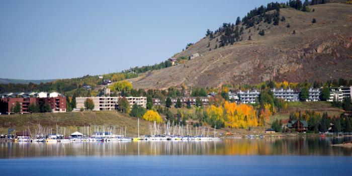
Goose Pasture Tarn. Photo credit: City of Breckenridge
Click the link to read the article on the Summit Daily website (Kit Geary). Here’s an excerpt:
February 4, 2026
A 54-year-old water treatment plant in Breckenridge has reached the end of its life, and preliminary cost estimates put rehabilitating it at $54 million. Breckenridge town staff members presented Breckenridge Town Council with plans for a series of projects to help the Gary Roberts Water Treatment plant reliably meet current demand at a Tuesday, Jan. 27, meeting. The Gary Roberts Water Treatment is located at the Goose Pasture Tarn. A staff memo stated the town first evaluated improvements and rehabilitation options in 2014, but they put those on hold to prioritize Goose Pasture Tarn dam repairs. The memo noted the continued aging of the plant now makes it a critical project. It included photos of the plan demonstrating pitting, corrosion and leaks in the water tanks at the plant…The project is currently proposed to be phased from 2027 to 2029. Staff members said there are no anticipated impacts to residents’ water service. While preliminary cost estimates put the project at $54 million, the budget the town planned for was $50 million. Officials asked staff members what tools were at the town’s disposal to make the project stay within a reasonable budget.
Click the link to read the article on the Sky-Hi News website (Ryan Spencer). Here’s an excerpt:
January 5, 2026
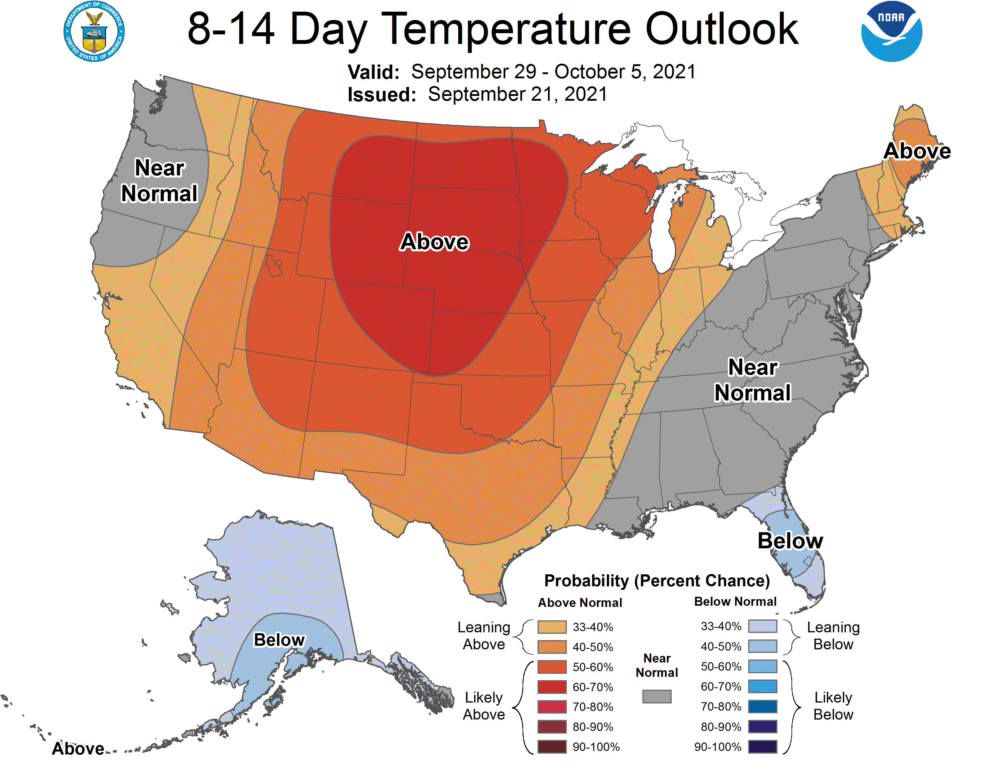
Across Colorado, this past December was among the hottest ever recorded. Both Denver and Grand Junction recorded their second-hottest December on record, according to the National Weather Service. Steamboat Springs, where the period of record dates to 1893, had its hottest December ever, averaging about 30 degrees through the month.
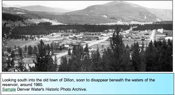
Dillon townsite prior to construction of Dillon Reservoir via Denver Water
In Dillon, where the period of record dates back to 1910, this past December was also the second-warmest on record, with a monthly average temperature about 28 degrees, about one degree cooler than 1980, which was the hottest December…At one weather station in Vail, temperatures averaged about 26 degrees Fahrenheit last month, making the hottest December recorded in the period of record that dates back to 1985. In Aspen, the average monthly temperature in December was 30 degrees, compared to the normal average monthly temperature of about 22 degrees for that month…
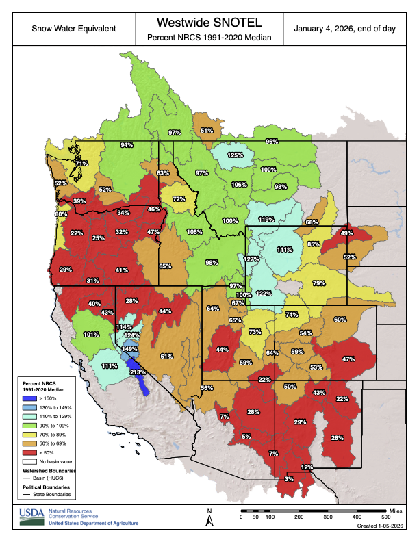
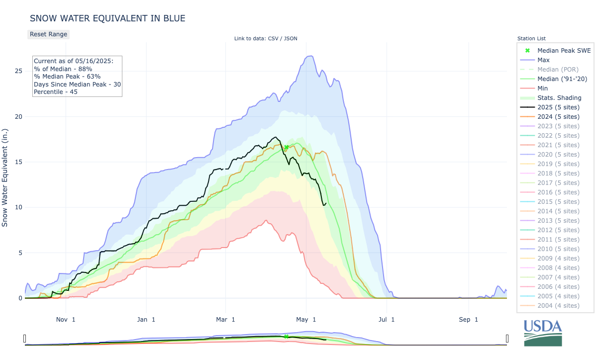
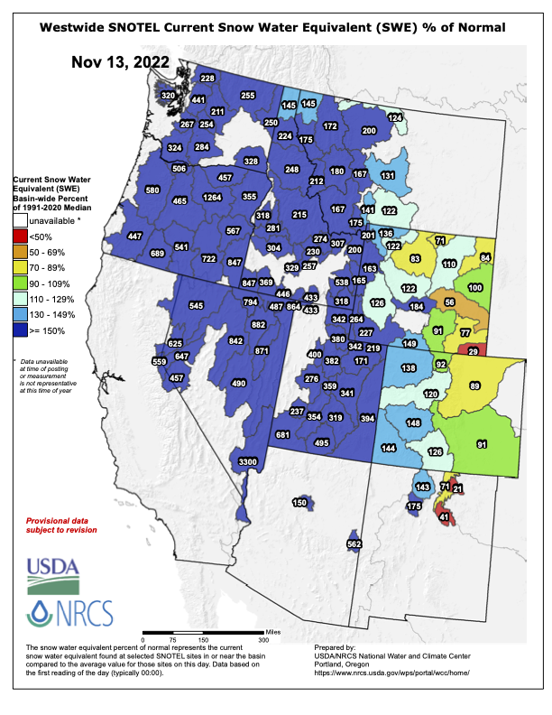
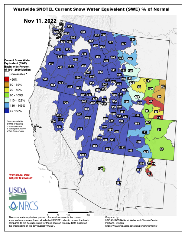
Westwide SNOTEL basin-filled map January 4, 2026.
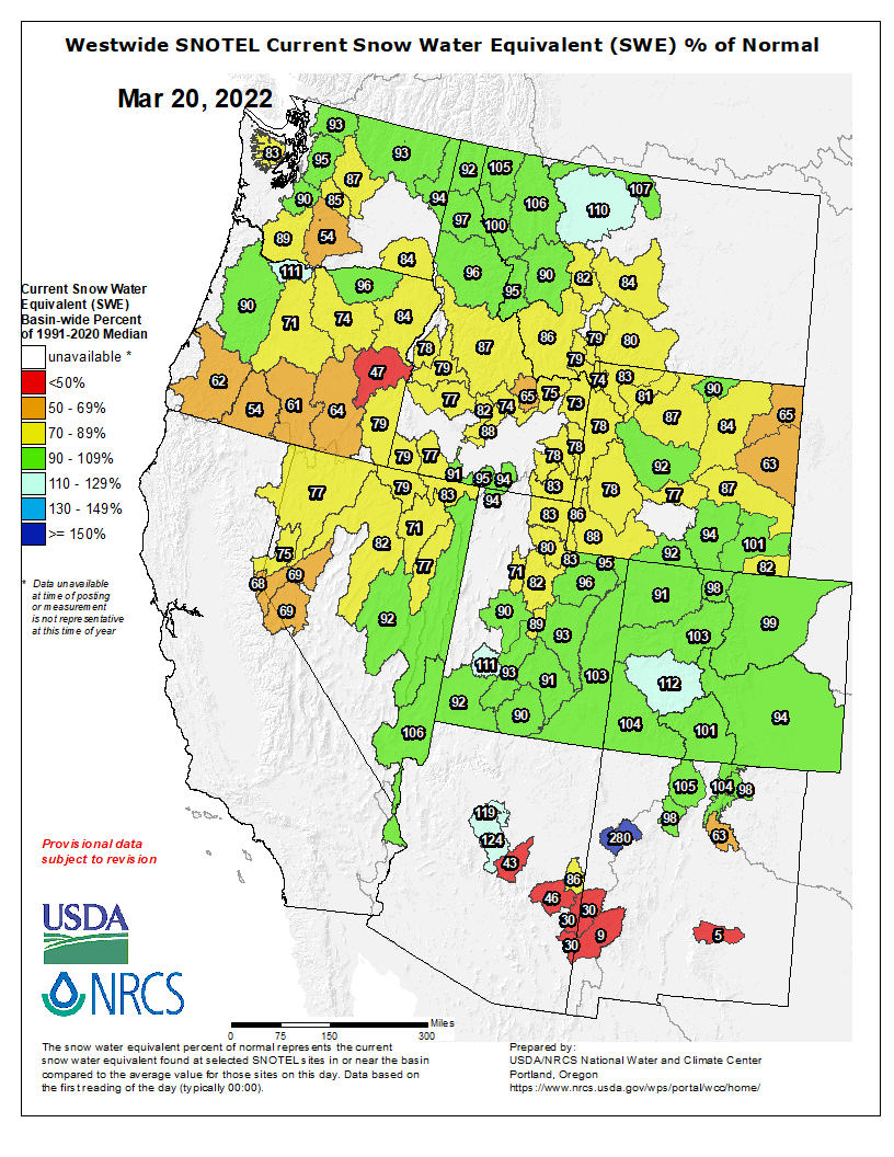
Across the state, the snowpack was also at or near record lows in several river basins, including those where popular ski resorts are located. Statewide, the sat at 59% of the 30-year median as of Friday, ranking in at the 5th percentile, meaning that 95% of years on record had more snow at this time. The Roaring Fork Basin and the Yampa River Basin both ranked in at the 3rd percentile. Meanwhile, the Eagle River Basin and the Colorado-Kremmling to Glenwood Springs Basin both came in at the zeroth percentile, meaning that the snowpack is the worst on record.
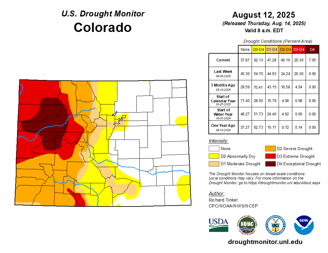
Colorado Drought Monitor map December 30, 2025.
With low amounts of precipitation and hot weather, drought conditions continue to sweep over the Western Slope, according to the most recent U.S. Drought Monitor map. Substantial portions of Eagle and Pitkin counties are now facing exceptional and extreme drought. Extreme drought has also pushed into Grand County, while the rest of Northwestern Colorado is facing moderate to severe drought.
Click the link to read the article on the Summit Daily website (Town of Silverthorne):
November 17, 2025
Starting Jan. 1, 2026, the metered water service rate for a normal rate building from $19.55 per equivalent residential unit per month to $22 per equivalent residential unit per month.
Also effective Jan. 1 2026, the town will increase its water system development fees by $276 per equivalent residential unit. This will bring the one-time fee to connect new development to the town’s water from $9,200 to $9,476.
“That’s really just to keep up with inflation,” Finance Director Laura Kennedy said. “Despite the fact that we are growing as a town, water usage really hasn’t grown as much as we’ve seen the number of units come on.”
Residential storm water management fee will also increase, taking the fee from $7.50 per month to $7.57 per month. The sewer opportunity fee — which is applicable to properties outside of town that receive sewer services from the town or will receive service because of a planned annexation — will increase in 2026 as well from $2,700 to $2,750.
With a newly approved grant of over $30,000 from the Colorado Basin Roundtable, the Blue River Watershed Group will install cameras and measuring devices on the river to report on stream conditions.
A news release stated the group will use a technical consultant to create a webpage with a community-facing geographic information system map to share water quality data, as well as information about how the data affects the Summit County community.
The database will share locations, data types, collection purposes and data quality objectives from each of the Blue River watershed’s collecting entities.
The grant was part of the more than $180,000 of spending the Colorado Basin Roundtable approved in its September meeting. The rest of the money is funding projects around the state.
The Colorado Basin Roundtable has awarded $20,000 to Rivers Edge West and the Desert Rivers Collaborative to support restoration planning and coordination in the Gunnison and Colorado river basins, according to a news release. De Beque received $50,000 for improvements it is making to its 24.4-acre River Park on the Colorado River. Rivers Edge West and the Desert Rivers Collaborative plan to use their money to help identify priority restoration sites, develop a geospatial database and story map, and contribute to regional initiatives including the Grand Valley River Corridor Initiative, supporting health riparian ecosystems in Mesa County, according to the release. De Beque received the $50,000 to support engineering and design work needed for riverbank stabilization. The park is going to include an amphitheater, pavilion, parking areas, boat ramp and arboretum…Other allocations approved by the roundtable are:
$15,000 for the Middle Colorado Watershed Council’s Grand Tunnel Ditch flume replacement project;
$30,600 for the Blue River Watershed Group’s Blue River water quality monitoring dashboard and GIS resources;
$30,000 for the Eagle River Coalition’s Homestake Valley stream crossings project;
$30,000 for the Center for Snow and Avalanche Studies, for dust-on-snow data collection and cosmic ray evaluation, with this funding being contingent on the project receiving similar support from the state’s eight other basin roundtables.
Up until late August, this summer has been particularly dry, both for the Denver region and for the West Slope, the source of half of Denver Water’s supply. And that combination has translated into a heavy workload for the utility’s largest reservoir, the 257,000-acre-foot Dillon Reservoir in Summit County.
Dillon Reservoir in Summit County is Denver Water’s largest reservoir. Photo credit: Denver Water.
A summer largely bereft of the monsoon rains (which bolster our water supply and reduce water use by our water-smart customers) combined with long stretches of days above 90 degrees pushed up demand among the 1.5 million people Denver Water serves.
The dry summer situation also triggered calls for more water from farmers and ranchers who have senior water rights that put them at the front of the line for receiving water from the South Platte River system. Denver Water’s supplies are also constrained on the north side of its system, as ongoing work on the Gross Reservoir Expansion Project requires the utility reduce the amount of water it stores in that reservoir during the project.
Dillon Reservoir provides Denver Water with a supplemental supply to use when the amount of water available from its south system source, the South Platte River, is not enough to meet demands.
That all combined to make Denver Water more heavily reliant on Dillon Reservoir than usual, forcing the utility to push higher volumes from Dillon through the Roberts Tunnel to the Front Range.
“A lot of factors combined to see us lean hard into our Dillon supplies this summer,” said Nathan Elder, manager of supply for Denver Water. “We know this impacts recreation, both what we release into the Blue River below the reservoir and the water levels for the marinas at Dillon Reservoir. We try very hard to maintain good conditions for recreation at Dillon, but this summer posed challenges.”
The Dillon Marina at Dillon Reservoir. Photo credit: Denver Water.
Overall, the amount of water flowing into Dillon was at just 70% of normal in the April-through-July stretch. July alone saw just 48% of typical flows into the reservoir — that’s 20,000 acre-feet below average, about the capacity of Antero Reservoir west of Fairplay.
The situation serves as a reminder for Denver Water customers to stay smart about water use.
Especially amid a hot, dry summer, customers should make sure to follow watering rules and skip irrigation during rainy periods. And they should consider landscape changes that replace thirsty turfgrass with plants that need less water.
Yet, despite relentless dry periods covering July and most of August, Denver Water customers did a good job managing irrigation. They used water at a rate of just about 2% above the five-year average, and just 1.6% above the longer term, 2000-2024 average.
These plants from Resource Central’s Garden In A Box program are water-wise and interesting throughout the year. Photo credit: Denver Water.
But even as Denver Water customers kept demands low by historical standards, the combination of conditions saw water levels in Dillon fall below levels optimal for the marinas at the reservoir by the end of August.
Typically, Denver Water tries to keep the surface of Dillon Reservoir at 9,012 feet in elevation through Labor Day. But this year, levels will fall a few feet below that.
And water volumes flowing out of Dillon into the Blue River — flows important to rafters and anglers — also fell significantly. Since late July, those outflows were about 100 cubic feet per second, about half of normal for this time of year. In August they dropped even further, to 75 cubic feet per second.
The overall picture began to improve slightly in late August, as the state benefited from a cooling trend and bursts of rainfall. The cooler, wetter weather in the metro area cut Denver Water customers’ demand for water in the Denver region, easing the need to pull as much water from Dillon.
Even so, the tough summer means Denver Water will likely enter the new, 12-month water year, which begins Oct. 1, with its reservoirs, including Dillon, at below-average elevations.
That puts the onus on the upcoming winter season to come through with a good snowpack, never a sure thing.
“We’ll hope to see water demands fall in September and then look to a good snowpack in the winter and spring,” Elder said.
“But we’ll be starting from behind. We hope we can make up the gap in reservoir storage with a wet winter and spring. And we’ll need our customers to help us with smart water practices.”
Click the link to read the article on The Denver Post website (Elise Schmelzer). Here’s an excerpt:
August 15, 2025
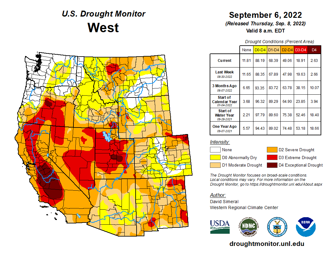
Drought and long, hot summer days are sucking Western Colorado’s rivers dry, parching farm fields and fueling the massive wildfires proliferating across the region. A chunk of northwestern Colorado in the last week plunged into exceptional drought — the most dire category recorded by the U.S. Drought Monitor. The swath of affected land represents 7% of the state and covers most of Garfield and Rio Blanco counties, as well as parts of Moffat, Mesa, Delta, Routt and Pitkin counties…Exceptional drought is expected to occur once every 50 years, [Russ] Schumacher said. So far this summer, the afternoon monsoon rains that provide relief have been largely absent from the Western Slope. The higher-than-normal temperatures and a lack of rain have sapped the rivers in the Western half of Colorado. Streamflows statewide are at only half of the median recorded between 1991 and 2020, according to National Water and Climate Center data. The lack of water has limited fishing and rafting opportunities, reduced agricultural irrigation and threatened river environments…Nearly half of Colorado is experiencing some level of drought, according to new data released Thursday by the U.S. Drought Monitor. More than 1.4 million people live in that drought-impacted area, which encompasses the entire western half of the state, parts of metro Denver and some areas of southern Colorado…
This summer has been one of the driest on record for the state’s critical Colorado River basin, similar to 2018 and 2021, said Calahan of the Colorado River District. Drought in those years made the Colorado River look more like a creek than a river and prompted a 120-mile-long fishing ban on its mainstem…Streamflow in the basin is worst on its western flank and best on its eastern side near the headwaters, he said…The [Colorado River] district is speaking weekly with irrigators across the region to best divvy up the water that remains. Low flows are being supplemented by releases from reservoirs…A lack of water in the Eagle River near Vail prompted local water authorities to warn of a potential coming water shortage. Flows on the river near Avon were about half of normal — and the third-lowest recorded on the stream gauge’s 26-year record, said Siri Roman, the general manager of the Eagle River Water and Sanitation District…Thirteen of the 14 stream gauges with historic data in the Upper San Juan basin were reporting flows below or extremely below normal on Wednesday. The Animas River in Durango was flowing at 153 cubic feet per second — a fraction of the median of 499 cfs for the day across 113 years of data, and close to the historic low for that date of 137 cfs…Several stream gauges in the basin were recording record daily lows, like the San Juan River in Pagosa Springs and on Vallecito Creek…On the opposite side of the state, the Yampa River basin, too, is struggling. The river above Stagecoach Reservoir was flowing at less than half of the 36-year median.
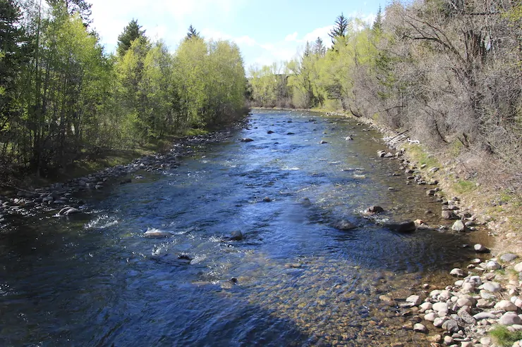
The Blue River flows through Silverthorne on May 22 on its way to the Colorado River. Photo/Allen Best
Click the link to read the article on the Big Pivots website (Allen Best):
May 29, 2025
Even-steven. That was the intent of delegates from the seven basin states in 1922 when they met near Santa Fe to forge a compact governing the Colorado River.
But what exactly did they agree upon? That has become a sticking point in 2025 as states have squared off about rules governing the river in the drought-afflicted and climate-changed 21st century. The negotiations between the states, according to many accounts, have been fraught with tensions. Becky Mitchell, Colorado’s lead negotiator, delivered a peek into that dispute at a forum on May 22 in Silverthorne along the headwaters of the river.
The Colorado River Compact was a quid pro quo. California, in particular, but also Arizona, was ready to see the highs and lows of the rivers smoothed out. They, as well as Nevada, wanted a giant reservoir in Boulder Canyon near the small town of Las Vegas, which then had a population of 2,300. Those Southwestern states couldn’t do it alone, though. They needed the federal government to build the dam later called Hoover. For that, they needed the support of Colorado and the three other upper-basin states.
Colorado, represented by Delph Carpenter, and the three other headwaters states realized that they had best reach a compromise, as they would more slowly develop the rivers. If the doctrine of prior appropriation that they had all adopted within their own states prevailed on the Colorado River, the water would be gone by the time they found need for it.
This was the foundation for Article III of the Colorado River Compact. It apportions 7.5 million acre-feet in perpetuity for the exclusive beneficial consumption by each of the two basins. On top of this 15 million acre-feet, they knew there would be water lost to evaporation, now calculated at 1.5 million acre-feet annually, plus some sort of delivery obligation to Mexico, which later turned out to be 1.5 million acre-feet.
In Santa Fe, delegates had assumed bounteous flows in the river, as had occurred in the years prior to their meeting. And so, embracing that short-term view of history, they believed the river would deliver 20 million acre-feet.
Source: Colorado River Water Conservation Board.
It has not done so routinely. Even when there was lots of water, during the 1990s and even before, as Eric Kuhn and John Fleck explained in their 2019 book, “Science be Dammed,” troubles ahead could be discerned. And by 1993, when the Central Arizona Project began hoisting water to Phoenix and Tucson, the river ceased absolutely to reach the ocean.
Then came the 21st century drought. Those framing the compact understood drought as a temporary affliction, not the multi-decade phenomenon now perplexing the states in the Colorado River Basin.
Nor did they contemplate a warming, drying climate called aridification. Similar to drought in effects, it is rooted in accumulating atmospheric gases. Unlike drought, it has little to no chance of breaking.
Now, faced with creating new rules governing the sharing of this river, delegates from the seven states are at odds in various ways, but perhaps none so much as in their interpretation of compact’s Article D. It says that the upper-division states “will not cause the flow of the river at Lee Ferry to be depleted below an aggregate of 75,000,000 acre-feet for any period of ten consecutive years.”
The lower division states have so far received 75 million acre-feet over every revolving 10-year period. The upper-basin states have not fully developed their apportionment, although Colorado has come close. In the last 25 years, the upper-basin states have been using 3.5 million to 4.5 million acre-feet. The lower-basin states that a decade ago were still using 10 million acre-feet have cut back their use to 7.5 million acre-feet.
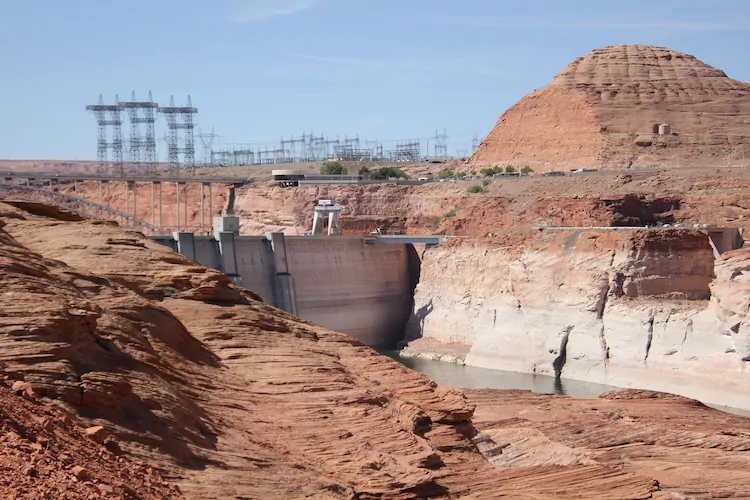
In May 2022, water levels at Glen Canyon Dam were dropping so rapidly as to make relevant discussions about potential loss of hydroelectricity. Photo credit: Allen Best/Big Pivots
Lake Powell serves as a water bank for the upper basin states. The storage in 2022 had declined to 22%, although a good snow winter in 2022-23 restored levels somewhat. Today, the two reservoirs are at a combined 34% of full.
“That means 66% empty,” said Mitchell at the forum along the Blue River in Silverthorne at a “state of the river” forum organized by the Colorado River Water Conservation District.
Mitchell, an engineer by training, has a large on-stage presence. She’s spunky, not one to mince words, sometimes straying into the colloquial. This outspokenness is more evident when she speaks exclusively to a home-town crowd. Silverthorne certainly counted as one.
Shared risk is at the heart of the dispute. Colorado and other upper-basin states want the lower-basin states to accept that the river will not always satisfy all needs.
“How do we handle drought? We know how to do that in the upper basin, and most of the people in this room know that you get less,” said Mitchell, Colorado’s representative on the Upper Colorado River Commission. “That hasn’t been the case in the lower basin.”
The two basins differ in three fundamental ways. One is the pace of development. The lower basin developed quickly. The upper basin still has not used its full allocation. From the upper-basin perspective, that does not mean that the lower-basins states should expect something beyond a 50-50 split.
“The main thing that we got from the compact was the principle of equity and the ability to develop at our own pace,” said Mitchell. “We shouldn’t be punished because we didn’t develop to a certain number. The conversation now, she added, is “what does equity look like right now?”
Another difference is that the upper basin has thousands of individual users. Sure, there are a few big ones, like Denver Water and the other Front Range transmountain water diverters who collectively draw 400,000 to 450,000 acre-feet annually across the Continental Divide. The lower basin has just a handful of diverters, and the diversions are massive.
Also different — as alluded to by Mitchell — is that the lower basin has the big reservoirs lying upstream. The largest is Mead, with a capacity of almost 29 million acre-feet, followed closely by Powell at a little more than 25 million acre-feet. Mead was created expressly to meet needs of irrigators and cities in the desert southwest.
Source: Colorado River Water Conservation Board.
Powell was created essentially to ensure that the upper-basin states could meet their delivery obligations. Mitchell shared a telling statistic: More water has been released from Powell in 8 of the last 10 years than has arrived into it.
Upper-basin states must live within that hydrologic reality, said Mitchell. If it’s a particularly bad snow year in the upper basin, the farms and ranches with junior water rights and even the cities can get shorted. The lower basin states? Not a problem. They always get their water — at least so far. But the two big reservoirs have together lost 50 million acre-feet of stored water.
“We’re negotiating how to move forward in a way different place than we were negotiating 20 years ago,” said Mitchell.
Upper-basin states have managed to deliver the 75 million acre-feet across 10 years that the compact specifies, but what exactly is the obligation? That has long been a gray area.
At a forum two days before Mitchell spoke in Colorado, her counterpart in Arizona, Tom Buschatzke, reiterated at a conference in Tucson that they see the compact spelling out a clear obligation of upper-basin states to deliver 75 million acre-feet plus one-half of the water obligated to Mexico.
What if the water isn’t there? That’s the crux of this dispute as the upper and lower basin states negotiate in advance of a September deadline set by the Bureau of Reclamation.
Denver Water sends diversions from the Ffaser River and other headwater tributaries through the Moffat Tunnel at Winter Park. Photo/Allen Best
In theory, if the situation were dire enough, Colorado could stop all its post-1922 diversions to allow the water to flow downstream. But is that what those gathered in Santa Fe in the shortening days of November 1922 had in mind?
Will lawsuits toss this into the court system for resolution? That process might take decades and, if it ended up at the Supreme Court, it might not yield a nuanced outcome. Mitchell didn’t address that directly, although she did say everybody on the river wants to avoid litigation.
The situation described by Mitchell and other upper-basin proponents is perhaps analogous to a divorce settlement. The settlement may call for a 50-50 split of all earnings between the partners, but what if one becomes destitute and has no money to pool?
Upper-basin states do have reservoirs to help buffer them from short-term droughts. Altogether, however, they don’t come close to matching the capacity of Powell.
Again, from the perspective of upper-basin states, California and Nevada have a sense of entitlement. Not that the upper basin states are angelic, said Mitchell. It’s because they have no choice.
“I say we use three to four million acre-feet less than our apportionment. It varies. You know why? Because hydrology varies. And so we respond to hydrology. It’s all based on snowpack and it’s all gravity. Most of it is gravity dependent. We don’t have those two big reservoirs above us like the lower basin does. We don’t have those reservoirs to equal out the flows or allow us to overuse. We have to live with variable hydrology, and we take cuts every single year.”
Upper-basin states want a willingness in this settlement for agreement that focuses on the water supply, not the demand. “Common sense would tell you, maybe Mother Nature should drive how we operate the system.” That, she said, is the bedrock principle of the proposal from the upper division.
With plentiful snowfall, greater releases from Powell might be possible, said Mitchell, and in times of extreme duress, water from Flaming Gore and perhaps the Blue Mesa and Navajo too. She said there might be room for greater conservation measures in the upper basin states.
But there must be “real work happening down in the lower basin,” she said.
The audience in Silverthorne was comprised of many “rookies” to the water world. Some who might have attended, those more knowledgeable about the negotiations, would have wanted more: What are the deal breakers; what are the red lines, what are the issues they intend to kick down the road?
As the session in Silverthorne neared its end, time remained for one last question, and I asked it:
“I have to wonder about who we have in the White House right now, and how the President might alter the negotiations on the Colorado River. Any thoughts you might be willing to share?
“No!” she barked back without hesitation. “Allen, you know better than that.”
I laughed heartily, and so did many others.
Given what we’ve seen since January, though, I must continue to wonder.
Postscript: Before her remarks in Silverthorne, Becky Mitchell offered the opportunity for an in-depth interview with Big Pivots sometime later in June. I intend to take up that offer.
Delph Carpenter’s original map showing a reservoir at Glen Canyon and one at Black Canyon via Greg Hobbs
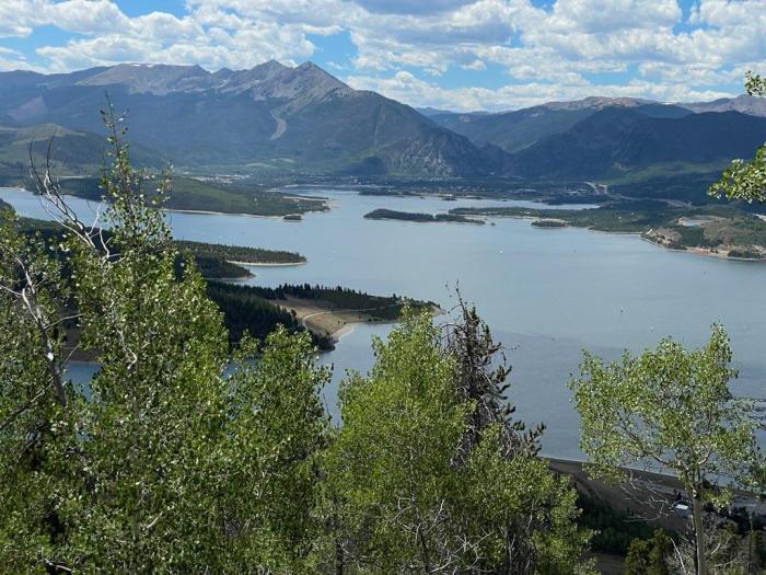
Grays and Torreys, Dillon Reservoir May 2017. Photo credit Greg Hobbs.
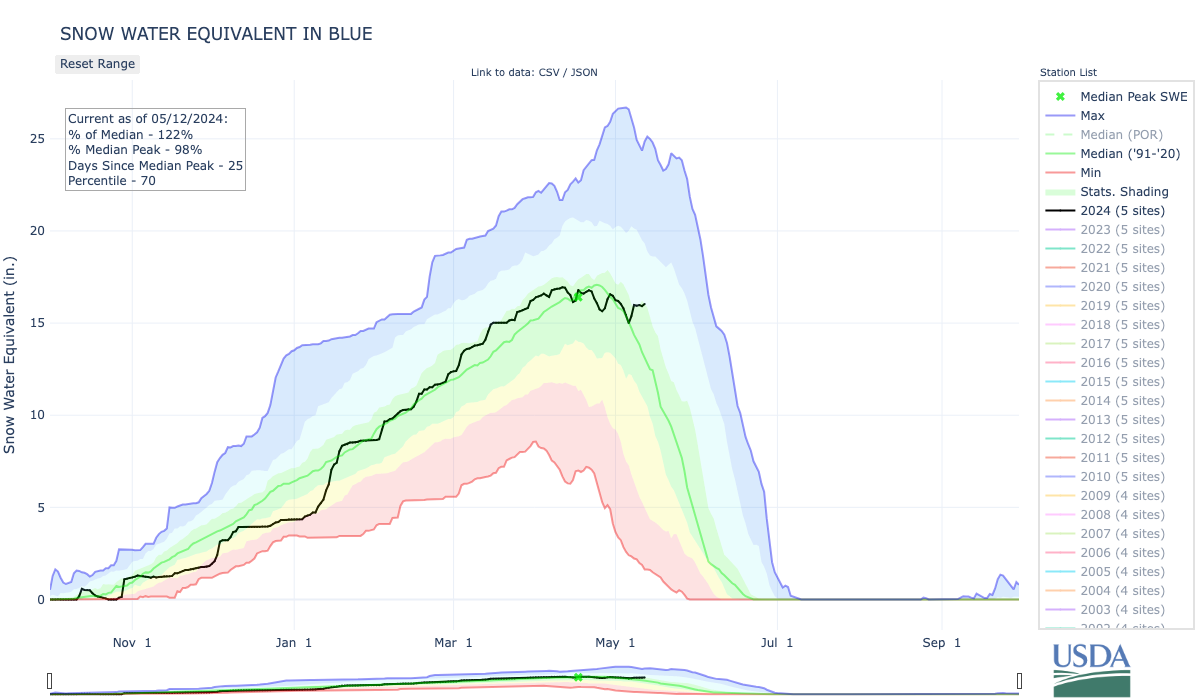
Click the link to read the article on the Summit Daily website (Ryan Spencer). Here’s an excerpt:
May 25, 2025
Both the Dillon Reservoir and the Green Mountain Reservoir are expected to reach capacity this summer, Colorado Division of Water Resources division engineer James Heath said at the State of the River in Silverthorne on Thursday, May 22…An about-normal snowpack in Summit County this winter means both reservoirs are expected to “fill and potentially spill,” Heath said. While the snowpack levels were close to normal, the runoff has been slightly below normal because the county went into last winter with dry soils, he said…
The snowpack in the Colorado River Headwaters Basin peaked April 7, about a week earlier than normal, Heath said. At 89% of the 30-year-median…The Blue River Basin [peaked] April 8, at 108% of the 30-year-median, Heath said…
.Dillon Reservoir should reach an elevation of 9,012 feet by June 18, allowing both the Dillon and Frisco marinas to be fully operational by that time. Outflows…should exceed 500 cubic feet per second — the level ideal for rafting the Blue River — around the third week in June and continue until around the Fourth of July weekend, he said.
Green Mountain Reservoir. Photo credit: Colorado Parks & Wildlife
Due to decreased water flow from Stagecoach Reservoir, Colorado Parks and Wildlife (CPW) will implement a mandatory full-day fishing closure on a 0.6-mile stretch of the Yampa River between the dam at Stagecoach State Park downstream to the lowermost park boundary.
To avoid and minimize fish mortality within this tailwater fishery, a closure will take effect beginning Monday, May 19, until further notice.
“We are trying to be proactive in protecting the outstanding catch-and-release fishery we have downstream of Stagecoach Reservoir,” said Marisa Eley, CPW Steamboat Springs Area Aquatic Biologist. “This closure is an effort to protect the resource by giving the fish a bit of a reprieve as they are prone to increased stressors related to these low-flow conditions.”
When water flows are minimal, fish become concentrated in residual pool habitat and become stressed due to increased competition for food resources. The fish become much easier targets for anglers, an added stressor that can result in increased hooking mortality.
CPW works closely with the Upper Yampa Water Conservancy District (UYWCD), which owns and operates Stagecoach Reservoir, to stay informed on reservoir releases.
“We are grateful for our partnership with UYWCD,” said Stagecoach State Park Manager Craig Preston. “Their dedication to keeping us updated on water flows in and out of the reservoir greatly contributes to protecting this unique fishery for current and future generations.”
“We will continue to closely monitor the inflow at Stagecoach Reservoir,” said Andy Rossi, UYWCD General Manager. “If we see increased inflow, we can respond quickly to adjust outflow and work with CPW to determine if the closure could be lifted.”
Like many rivers and streams in Western Colorado, the Yampa River offers world-class fishing and attracts thousands of anglers every year.
For more information or current fishing conditions at Stagecoach State Park, call 970-736-2436.
For more information about fishing in Colorado, including current fishing conditions and alternative places to fish, visit the CPW website.
Click the link to read the article on the Summit Daily website. Here’s an excerpt:
May 15, 2025
The Colorado River District will hold one of its 11 “State of the River” events in Silverthorne on Thursday, May 22. The event, held in partnership with the Blue River Watershed Group, will be held at the Silverthorne Pavilion from 6 p.m. to 8 p.m., according to the Colorado River District’s website…
Presentations will cover topics including current river conditions and seasonal forecasts, updates on the Colorado River system, local water projects affecting the Blue River in Summit County, updates on the Shoshone River water rights efforts, conservation efforts in the region and updates on recent legislative efforts. Registration is required. To register for the “State of the River” event visit ColoradoRiverDistrict.org/state-of-the-river-meetings-2025
Click the link to read the article on the Summit Daily website (Kyle McCabe). Here’s an excerpt:
May 9, 2025
Snowpack in the Blue River Basin, which encompasses all of Summit County, stood at 90% of the 30-year median as of Friday. The figure shows that Summit is in a good position compared to the state as a whole, which sat at 58% of the median. Aldis Strautins, a service hydrologist with the National Weather Service in Boulder, said that 90% of the median is “within normal ranges.” He added that some lower elevation areas of Summit County, like the 9,350 foot-elevation snow telemetry monitoring site at Summit Ranch, have already melted out or gotten close.
“Some of the higher sites, like your Copper Mountain and Fremont Pass, those are still doing fairly well,” Strautins said. “Still have quite a bit of snowpack up there, which would make sense for this time of year.”
The Dillon Reservoir currently sits at 84% of its capacity, according to the Denver Water website.
Click the link to read the article on the Summit Daily website (Ryan Spencer). Here’s an excerpt:
March 29, 2025
While a federal judge has ordered the Trump Administration to unfreeze federal funds, the National Council of Nonprofits says its continues to receive reports of nonprofits struggling to access federal grant money
A habitat restoration project aimed at restoring Gold Medal fishing status along a stretch of the Blue River that flows through Silverthorne is being impacted by a federal funding freeze. The Blue River Watershed Group — a local nonprofit that received $1.8 million in grant federal funding for the restoration project in December 2023 — told the Silverthorne Town Council earlier this month that the federal government has paused disbursement of those funds.
“Grant funding for this project through the Bureau of Reclamation’s WaterSMART Aquatic Ecosystem Project grant is affected by the recent pauses in federal grant funding,” Blue River Watershed Group executive director Vanessa Logsdon said in a statement Thursday, March 28.
The Blue River Watershed Group has partnered with Trout Unlimited and the town of Silverthorne, which has provided $150,000, on the project. The $1.8 million federal grant is to complete the engineering and design for the habitat restoration project, which focuses on the stretch of the Blue River from the Dillon Reservoir to the Columbine Campground north of Silverthorne. Studies have shown that that stretch of river is impacted by unnatural temperatures from dam releases that can be too warm in the winter and too cold in the summer, disrupting the life cycles of aquatic organisms such as trout. The project aims to get the Blue River back to a more natural cycle and restore the Gold Medal fishing status that stretch of river lost in 2016.
Snowfall in March has helped decrease the likelihood of drought developing this spring in Colorado’s northwest mountains. However, a warm and dry spring could still change the tide heading into summer. The National Weather Service, a division of the National Oceanic and Atmospheric Administration, released its latest seasonal drought outlook on Thursday, March 20. It showed that drought conditions are unlikely to develop in most of northwest Colorado through June…Brad Pugh, a forecaster with the National Oceanic and Atmospheric Administration’s climate prediction center, said these outlooks predominantly take into account the current conditions, climatology temperature and precipitation outlooks over the next three months.
“In northwestern Colorado at this time of year, you know going into the springtime, mountain snowpack is a critical factor,” Pugh said.
As of March 18, much of northwest Colorado was in line with, or just above, normal snowpack. This has continued to improve in the state’s north-central mountains since January. According to OpenSnow, as of Monday the snow totals and percentage of normal on the season so far were as follows:
Winter Park – 315 inches (117%)
Copper Mountain Resort – 303 inches (113%)
Vail Mountain – 292 inches (101%)
Breckenridge Ski Resort – 284 inches (107%)
Steamboat Resort – 279 inches (108%)
Aspen Highlands — 267 inches (88%)
Loveland Ski Area – 261 inches (108%)
Snowmass – 243 inches (83%)
Keystone Resort – 239 inches (107%)
Beaver Creek – 227 inches (108%)
Arapahoe Basin Ski Area – 225 inches (112%)
Aspen Mountain – 210 inches (92%)
Ski Cooper – 206 inches (106%)
Buttermilk – 147 inches (89%)
Colorado Drought Monitor map March 25, 2025.
The latest U.S. Drought Monitor for Colorado reported no drought in many of the northwest counties including Summit, Grand, Routt and Jackson counties as well as the eastern reaches of Eagle and Moffat counties. Heading west, the monitor shows abnormally dry conditions in Pitkin County and the eastern portions of Garfield and Rio Blanco counties. Conditions continue to get progressively drier the further west toward the border.
Mid-February’s weeklong series of storms that dropped 4-to-5 feet of snow in areas of Denver Water’s collection area could be termed a “Sweetheart Surprise,” followed by a dumping of “Presidents Day Powder” that just kept going.
“It was an impressive week of snow with a bullseye right on our collection area,” said Nathan Elder, Denver Water’s manager of water supply. “After a couple dry weeks to start out the year, it was nice to see stormy winter weather return to the mountains.”
Elder said mountain snowpack in the parts of the South Platte and Colorado River basins where Denver Water collects its water jumped significantly due to the storms.
From Feb. 14-21, snowpack in the Upper South Platte River Basin climbed from 84% of normal up to 108%. During the same time period in the Upper Colorado River Basin, the snowpack jumped from 105% of normal up to 120%.
Snow piles up along the banks of Tenmile Creek near Copper Mountain in Summit County on Feb. 19. The creek is one of the main tributaries of Denver Water’s Dillon Reservoir. Photo credit: Denver Water.
However you look at it, all the snow in the second half of February has been great news for our water supply. And there’s an interesting trend happening during the 2024-25 snow season in Colorado: The major storms keep hitting on the holidays.
The February storm cycle started just in time for Valentine’s Day, Feb. 14, continued dumping through Presidents Day, Feb. 17, and then another storm delivered a bonus round of snow Feb. 20-21.
The snow is good news for Denver Water, which relies on mountain snow to supply water to 1.5 million people in the metro area.
Just take a look at the snow totals from the weeklong series of storms that spanned Feb. 14-21, as reported by the ski resorts located in Denver Water’s collection area:
Arapahoe Basin: 43”
Breckenridge: 47”
Copper Mountain: 45”
Keystone: 47”
Winter Park: 62”
A snowboarder enjoys fresh powder at Winter Park in Grand County. The ski resort reported 62” of snow between Feb. 14-21. Photo credit: Winter Park Ski Resort.
It’s been a great winter so far at Winter Park and Copper Mountain, which have seen 257” and 255” of snow respectively as of Feb. 21, making them the two snowiest ski resorts in the state.
Snowpack is a measurement of the amount of water in the snow if it were to melt. In general, about 10 inches of snow melts down to around 1 inch of water here in Colorado.
Elder said what’s been interesting this year is that the majority of snow has fallen right around holidays starting after Halloween, then before Thanksgiving, between Christmas and New Years, and now between Valentine’s Day and Presidents Day.
“We can see the snowpack looks like steps on our charts around all these holidays,” Elder said. “With the recent storms, we saw basically an entire month’s worth of snow in seven days.”
Elder said that having the snowpack above 100% heading into March is a good sign for our water supply in the coming year.
The Fraser River at the bottom of Berthoud Pass is covered in snow. The river is part of the Colorado River Basin where Denver Water captures snow for its water supply. Photo credit: Denver Water.
“March and April are typically our snowiest months of the year in Colorado. Those two months usually provide about one-third of our annual snowpack. That’s because the snow that falls in those months has a higher water content than snow that falls in the beginning and middle of winter,” he said.
Denver Water’s total reservoir supply stands at 82% full as of Feb. 21, which is about average for this time of year. Remember that reservoir levels fall over the winter and then go back up in the spring when the snow melts.
As for what to expect for the rest of the ski season, maybe consider heading to the hills on St. Patrick’s Day or Easter, and who knows possibly even Mother’s Day in May!
The Colorado River District’s State of the River meetings are a spring tradition in Western Colorado, bringing communities together to discuss the most pressing water issues facing our region. These free public events provide valuable insights into river forecasts, local water projects, and key challenges impacting West Slope water users.
Eleven meetings are planned across the Western Slope; see the list below. These events offer an opportunity to hear directly from water experts and better understand the factors shaping the future of our rivers. A complimentary light dinner will be provided, and all events include a Q&A session to address your questions and concerns.
While each program is tailored to reflect local water priorities, key topics at all events will include:
River flow forecasts
Updates on the Colorado River system
Local water projects and priorities
Current challenges facing Western Colorado water users
Shoshone Water Rights Preservation Project updates
If there are specific local issues or projects you would like to see highlighted, please include that information in your registration.
Registration is required, but attendance and dinner are free. We encourage all community members—whether deeply involved in water issues or just beginning to engage—to join us and participate in this important conversation.
Secure your spot today and be part of shaping the future of water in Western Colorado.
Click each event below to register!
Agendas will be posted for each meeting once they are finalized.
Snowpack levels in the Blue River Basin, which includes all of Summit County, are above normal. This winter’s levels are shown in black, last winter’s levels are shown in orange, the 2022-23 winter is shown in purple and the green line shows the 30-year median, or historic norm. U.S. Department of Agriculture/Courtesy illustration
Click the link to read the article on the Summit Daily website. Here’s an excerpt:
Snowpack levels across the entire state are currently below normal. This winter’s levels are shown in black, last winter’s levels are shown in orange, winter 2022-23 is shown in purple and the green line shows the 30-year median, or historic norm. U.S. Department of Agriculture/Courtesy illustration
While statewide snowpack levels are below normal, areas near Summit County are reporting above-normal levels, as indicated by the green and blue dots. U.S. Department of Agriculture/Courtesy illustration
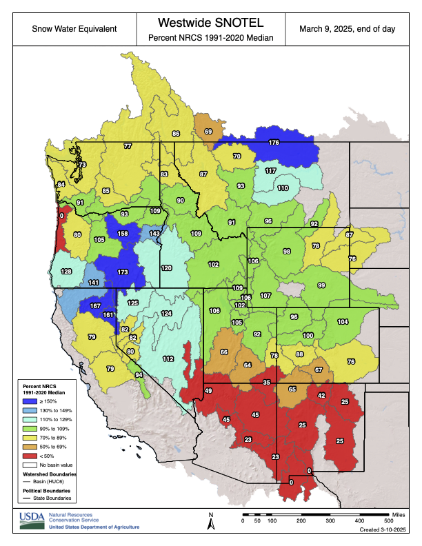
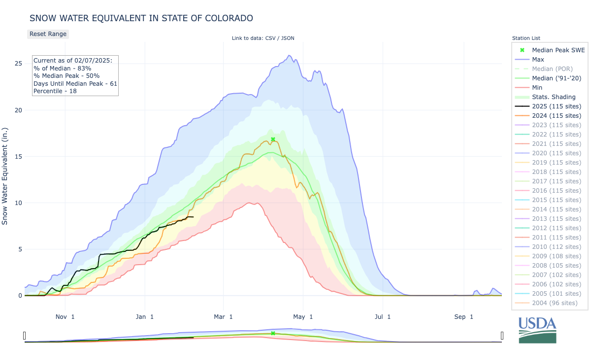
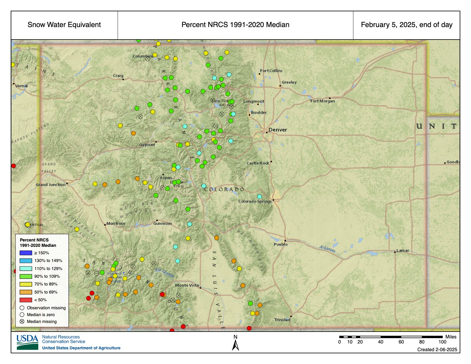
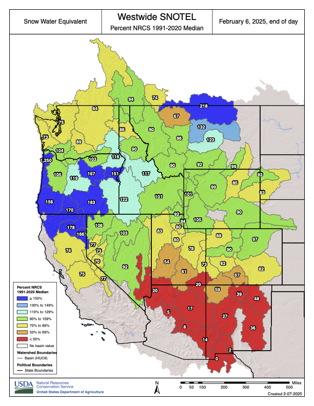
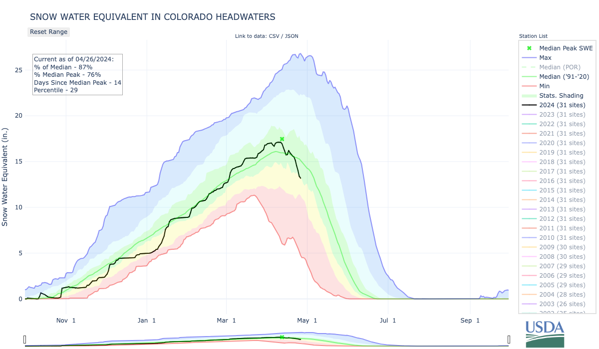
Westwide SNOTEL basin-filled map February 6, 2025 via the NRCS.
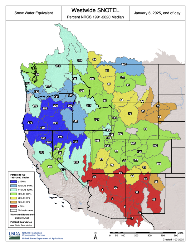
Westwide SNOTEL basin-filled map January 6, 2024 via the NRCS.
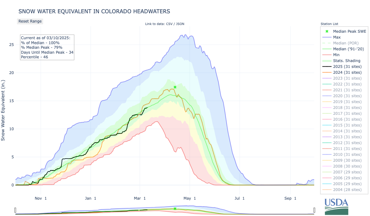
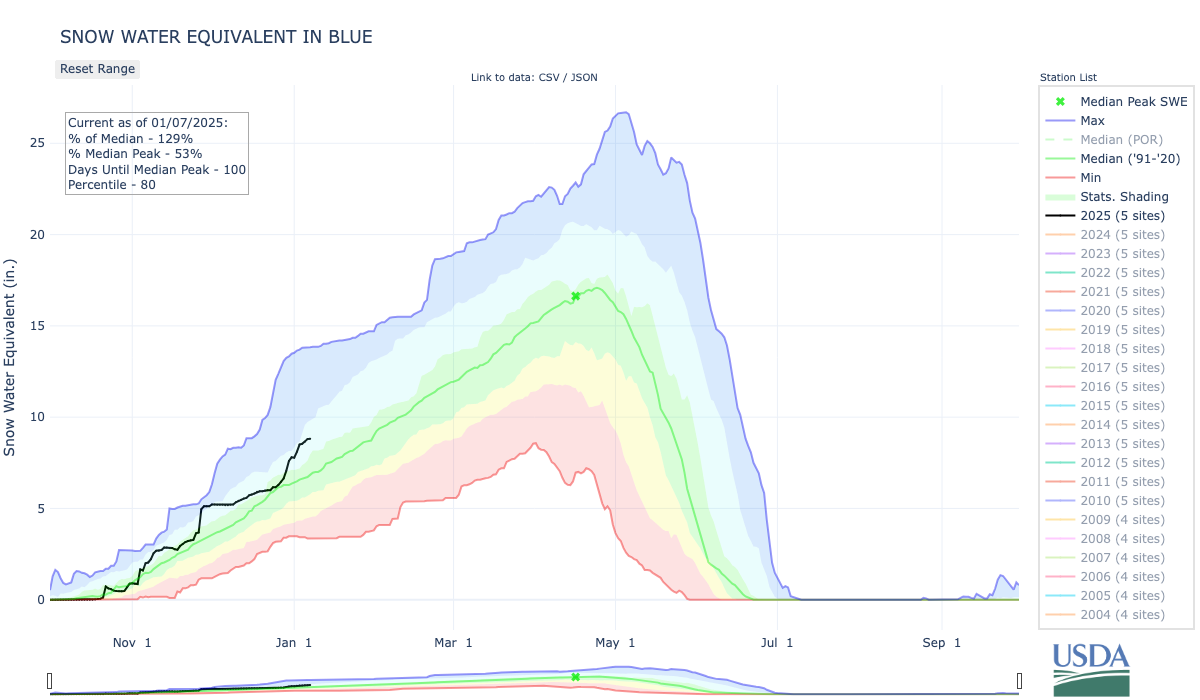
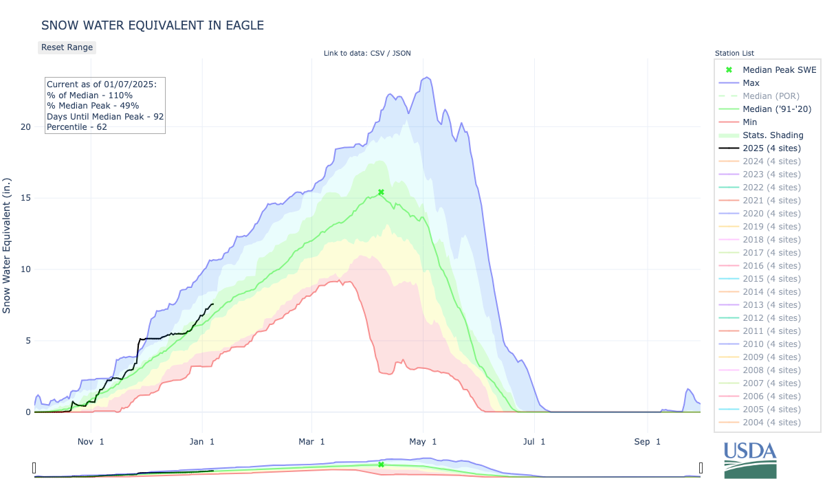
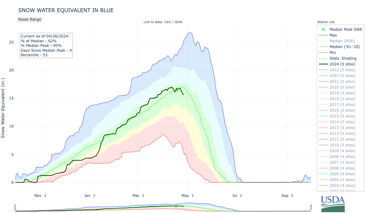
Click the link to read the article on the Summit Daily website (Kit Geary). Here’s an excerpt:
January 5, 2025
Summit and Eagle counties are poised to get a consistent dusting of powder nearly everyday this week heading into next weekend, according to National Weather Service meteorologists. Meteorologist Zach Hiris said there will be a “fairly active pattern across the mountains” on Monday, Jan. 6, and Tuesday, Jan. 7, which is likely bring a few inches of snow to the slopes. He said “a bunch of weak systems” could follow from Wednesday through Saturday and these are slated to bring a couple more inches. Summit’s mountains are anticipated see anywhere from 3-6 inches and its valley areas could see 1-3 inches of snow by Wednesday morning, Hiris said. Wednesday, Thursday and Friday could bring an inch or two each, but it will be more sporadic than the snowfall delivered by Monday and Tuesday’s storms, he said.
Hiris said the Blue River Basin is currently at 129% of its snowpack median.
According to the United States Department of Agriculture, the Colorado Headwaters river basin is currently at 104% of its median snowpack, the Eagle area is at 113% of its median snowpack and the Roaring Fork area is at 109% of its median snowpack.
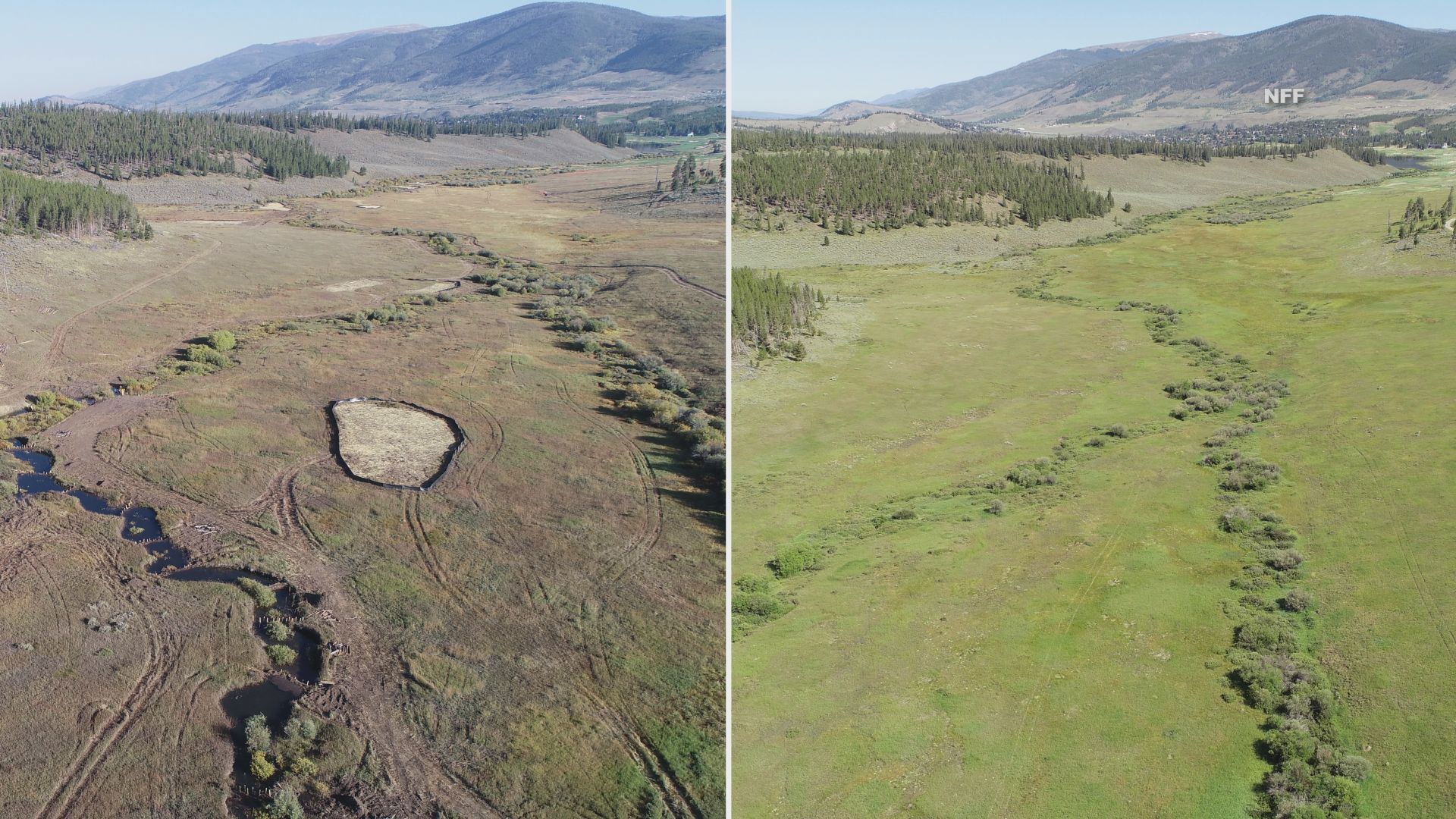
Before and after photos show a drastic change to the landscape. Credit: National Forest Foundation
Click the link to read the article on the 9News.com website (Brianna Clark). Here’s an excerpt:
September 17, 2024
Wetlands play a major role in keeping our water clean. Yet, according to the National Forest Foundation, the U.S. has lost more than half of them in the lower 48 states because of infrastructure development and agricultural practices. The Soda Creek Restoration Project hopes to undo some of that loss in Colorado…The project is part of a larger effort to restore 40 acres of wetlands in the White River National Forest, reestablishing nearly 30 acres while rehabilitating another 12.5 acres. The NFF started the project last month and all the work is being done by hand with the help of volunteers. One of several things they’re doing is creating dams to slow down the water allowing it to spread out over the valley. NFF Colorado River Watershed Program Coordinator Adde Sharp said the historic wetland in Summit County was converted into a cabbage farm more than a hundred years ago, causing the area to dry up and the landscape to change. Sharp said turning the area back into a wetland is a big deal because Soda Creek is upstream of Dillon Reservoir, which provides drinking water to the Denver area.
“Wetlands dramatically improve water quality because they’re like sponges or filters that are filtering out sediment and different contaminants in the water, heavy metals, etc.,” said Sharp. “If you live downstream of a wetland- and we all do, there are wetlands upstream of all of us- this is really improving your water quality.”
Click the link to read the article on the Summit Daily website (Ryan Spencer). Here’s an excerpt:
June 8, 2024
The restoration work is proposed along a section of the Blue River near its confluence with the Colorado River in Kremmling
If a land exchange in Summit and Grand counties is completed, this ¾ mile stretch of the river could be Rosgen’s next project. The Bureau of Land Management approved the Blue Valley of Land Exchange last year. After dismissing public protests against the exchange last month, the federal bureau is now queuing up the final steps required to complete the land swap. The land exchange between the federal government and Blue Valley Ranch, which is owned by billionaire Paul Tudor Jones II, has been decades in the making. It was first proposed in some form in 2001 with the stated purpose of addressing the “checkerboard nature” of ownership in the area.
A map shows the existing public and private parcels, left, as well as how the land ownership would change if the Blue Valley Ranch land exchange goes through. `Bureau of Land Management/Courtesy illustration
As part of the deal, the federal government would convey nine parcels totaling 1,489 acres to Blue Valley Ranch, while the ranch would transfer nine parcels of private land totaling 1,830 acres to public ownership. Blue Valley Ranch has also agreed to provide Summit County with $600,000 for new open space acquisitions as well as to construct a seasonal takeout and rest stop near the Spring Creek River Bridge and another rest stop 3 miles downstream. But Rosgen said what makes the land exchange a “win-win,” in his eyes, is Blue Valley Ranch’s commitment to cover the costs of river restoration work on that ¾ mile stretch, and the creation of the Confluence Recreation Area, which would have more than 2 miles of new walking trails and offer wheel-chair accessible fishing.
Click the link to read the article on the Summit Daily News website (Ryan Spencer). Here’s an excerpt:
May 11, 2024
Dillon Reservoir will “fill and spill” for the second year in a row, Denver Water announced this week. Dillon Reservoir – which is [part of] Denver’s public water supply – is currently 87% full, matching the average for May, according to Denver Water. Natural streamflow into the reservoir is predicted to be 101% of normal this runoff season and, right now, inflow into the reservoir is about 350 cubic feet per second. With the reservoir levels expected to reach an elevation of 9,012 feet by June 12, Denver Water said that it expects both the Dillon and Frisco marinas could be fully operational by that date. As inflows into the reservoir increase over the next week, Denver Water said it will ramp up outflow to the Blue River to between 200 and 400 cubic feet per second. Then, the following week, outflow may be adjusted to accommodate the Colorado Park and Wildlife’s fish survey and will likely remain in the 250 to 400 cubic feet per second range.
But by the end of May or early June, [Kevin] Foley said that he expects the Blue River will be open to commercial rafting, which requires at least 500 cubic feet per second. He expects the season could last three to four weeks, though it could be longer or shorter depending on weather. With a healthy snowpack peak of 119%, Foley said that the conditions for rafting could be pristine this summer. That is enough of a snowpack to fill the Dillon Reservoir and have other rivers in the state flowing too, but it is not so much that it will create too strong of streamflows for commercial rafting, he said.
Click the link to read the article on the Summit Daily website (Robert Tann). Here’s an excerpt:
April 23, 2024
This past winter marked the first in three years to experience an El Niño season. But what impact the pattern had on the Rocky Mountains is harder to tell compared to other parts of the state. In Breckenridge, for example, the majority of winter and early spring netted above-average precipitation, something that would be associated with a La Nina year, said Kenley Bonner, meteorologist for the National Weather Service office in Boulder. November was the only month to see below-normal precipitation, while the rest of the months through March were above normal, Bonner said. Temperature wise, this past winter was warmer than average, according to data collected in Dillon. The same can be said for much of the Western Slope. In Grand Junction, monthly average temperatures have hovered around 4 degrees above normal since November, said Lucas Boyer, meteorologist for the National Weather Service office in Grand Junction…
The same was true for the entirety of the Colorado River Headwaters Basin, which includes some central and northern mountain areas as well as parts of the Western Slope…
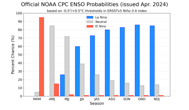
NOAA Climate Prediction Center forecast for each of the three possible ENSO categories for the next 8 overlapping 3-month seasons. Blue bars show the chances of La Niña, gray bars the chances for neutral, and red bars the chances for El Niño. Graph by Michelle L’Heureux.
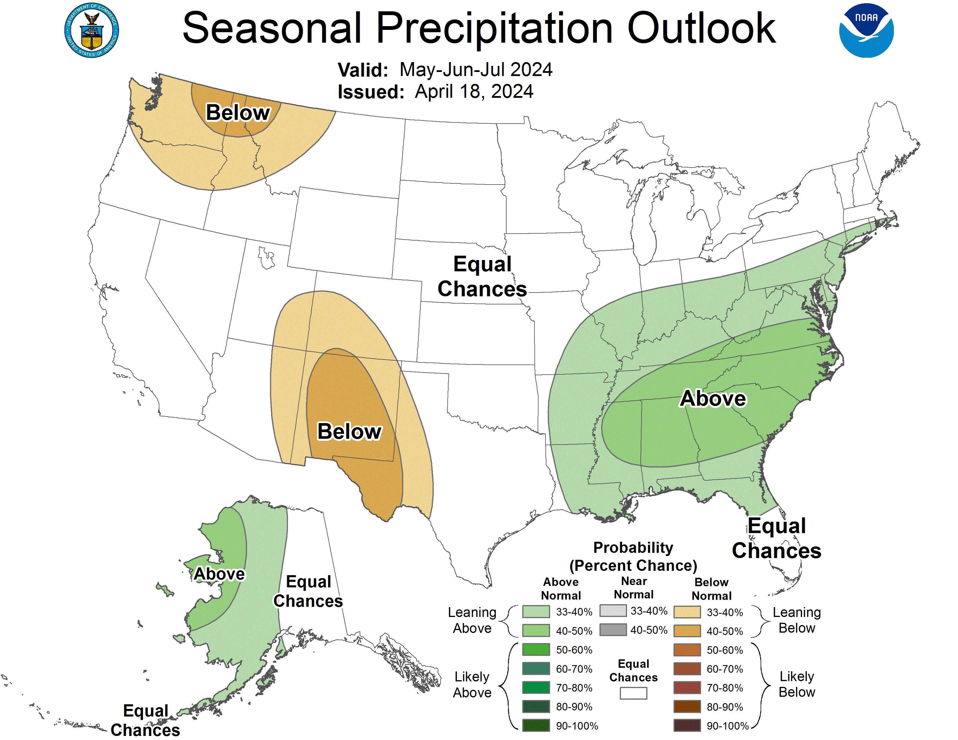
A three-month outlook released by the prediction center on April 11 shows Colorado has between a 33% and 50% chance of experiencing above-normal temperatures for May, June and July in various areas. The southwestern portion of the state also has between a 33% and 40% chance of seeing below-normal precipitation during that period, while the northeastern portion has equal chances of seeing above- or below-normal precipitation.
BRWG has partnered with Trout Unlimited to create an Integrated Water Management Plan (IWMP) for the Blue River Watershed, that will provide a comprehensive roadmap for future water use, restoration projects, and other solutions to the issues that currently threaten the health of the watershed. The IWMP will guide the strategic direction of BRWG for the next several years through ongoing scientific research and resource evaluation, planning of restoration projects and acquiring funds to sustain those projects, implementation of projects that have secured funding as well as evaluating and maintaining completed projects.
Montgomery Reservoir, a source of water for Colorado Springs Utilities, can hold about 5,700 acre-feet of water. As the result of an agreement with West Slope opposers, Colorado Springs will be allowed to enlarge the reservoir to hold an additional 8,100 acre-feet without West Slope opposition. CREDIT: COLORADO SPRINGS UTILITIES
Colorado Springs has agreed to give up water rights tied to reservoirs in the Blue River basin in exchange for the ability to expand Montgomery Reservoir on the east side of the Continental Divide without opposition from Western Slope entities.
Colorado Springs Utilities had been fighting in water court since 2015 to hang on to conditional water rights originally decreed in 1952 and tied to three proposed reservoirs: Lower Blue Reservoir, on Monte Cristo Creek; Spruce Lake Reservoir, on Spruce Creek; and Mayflower Reservoir, which would also have been built on Spruce Creek. Lower Blue Reservoir was decreed for a 50-foot-tall dam and 1,006 acre-feet of water; Spruce Lake Reservoir was decreed for an 80- to 90-foot-tall dam and 1,542 acre-feet; and Mayflower Reservoir, was decreed for a 75- to 85-foot-tall dam and 618 acre-feet.
After negotiations with eight opposers, including the Colorado River Water Conservation District, Summit County and the town of Breckenridge, the parties are set to approve an agreement that would cancel the conditional water rights for Spruce Lake and Mayflower reservoirs. A third potential reservoir, Lower Blue, would keep its 70-year-old rights, but Colorado Springs would transfer the majority of the water stored to Breckenridge and Summit County, and would share the costs of building that reservoir, which would be owned and operated by Breckenridge and Summit County.
In exchange, the Western Slope parties will not oppose Colorado Springs’ plan to enlarge Montgomery Reservoir to hold an additional 8,100 acre-feet of water for a total capacity of about 13,800 acre-feet. That project is expected to enter the permitting phase in 2025. After the permitting and construction of the Montgomery Reservoir expansion, the conditional water rights for Spruce Lake and Mayflower reservoirs would be officially abandoned and the water rights for Lower Blue Reservoir transferred to Summit County and Breckenridge.
“These conditional rights we’re relinquishing in the agreement are for future reservoirs that would be difficult to permit and build for us,” Jennifer Jordan, senior public affairs specialist at Colorado Springs Utilities (CSU), said in an interview with Aspen Journalism. “And we can gain in average years that same yield and perhaps a little bit more by getting the Montgomery Dam enlargement completed.”
A 2015 evaluation of the conditional water rights and proposed reservoirs by Wilson Water Group found several potential environmental and permitting stumbling blocks, including the presence of endangered species and challenging high-Alpine road construction.
CSU also agreed to a volumetric limit of the amount it will be allowed to take through the Hoosier Tunnel after the Montgomery Reservoir expansion: 13,000 acre-feet per year over a 15-year rolling average. CSU currently takes about 8,500 acre-feet per year through the tunnel.
Montgomery Reservoir is part of CSU’s Continental Hoosier System, which takes water from the headwaters of the Blue River between Breckenridge and Alma to Colorado Springs via the Hoosier Tunnel, Montgomery Reservoir and Blue River Pipeline. It is the city’s oldest transmountain diversion project.
Each year, transmountain diversions take about 500,000 acre-feet from the Colorado River basin to the Front Range. Colorado Springs is a large water user that draws from this vast network of tunnels and conveyance systems that move water from the mountainous headwaters on the west side of the Continental Divide to the east side, where the state’s biggest cities are located. Colorado Springs’ largest source of Western Slope water is its Twin Lakes system, which draws from the headwaters of the Roaring Fork River above Aspen.
Proposed reservoirs on the Blue River
Map: Laurine Lassalle – Aspen Journalism Source: Colorado Springs Utilities Created with Datawrapper
CSU to support Shoshone
The Glenwood Springs-based River District was created in 1937 to combat these types of diversions and keep water on the Western Slope. It was one of the entities that opposed CSU’s conditional water rights in its nearly nine-year water court battle, which kicked off when the water provider filed a diligence application. That is the process in which a conditional water-right holder must demonstrate to the water court that it can and will eventually develop the water right, and that in the previous six years, it has done its diligence in seeing a project through.
On Jan. 16, the River District board approved the settlement agreement, which includes a commitment from Colorado Springs that the utility will support the River District’s efforts at securing the Shoshone water right.
The River District is working to purchase water rights from Xcel Energy associated with the Shoshone hydropower plant in Glenwood Canyon. The water rights date to 1902 and are nonconsumptive, meaning the water would stay in the river and flow downstream to the benefit of the environment, endangered fish and other water users on the Western Slope. The Colorado Water Conservation Board approved $20 million toward the $98.5 million purchase last week.
“The settlement provides additional local water supplies to the Blue River Valley and a commitment of support from Colorado Springs Utilities for the Shoshone Water Right Preservation effort, which provides substantial benefits to the health of the entire Colorado River, including important water security, economic and environmental benefits to the West Slope,” River District General Manager Andy Mueller said in a prepared statement. “In addition, the West Slope will benefit from clearly specified limits on the total amount of water Colorado Springs can divert through its Continental-Hoosier transmountain diversion tunnel.”
The agreement was also good news for Breckenridge, which will split the 600 acre-feet of water from Colorado Springs in a future Lower Blue Reservoir equally with Summit County. The reservoir was originally decreed for 1,006 acre-feet, but the agreement now limits the reservoir capacity to 600 acre-feet. Colorado Springs will retain the remaining amount, about 400 acre-feet, which can be stored in Montgomery Reservoir.
Breckenridge Mayor Pro Tem Kelly Owens said Breckenridge will be able to use the stored water in late summer, when flows in the Blue River are at their lowest.
“The way we see it is that we’ve now protected those waters, the snowmelt, and keeping it in the Blue River basin,” Owens said.
According to the agreement, Colorado Springs would pay 50% of the construction costs of a future Lower Blue Reservoir, and Breckenridge and Summit County would each pay 25%.
Colorado Springs City Council is expected to approve the agreement at its Feb. 13 meeting.
This story ran in the Feb. 5 edition of the Summit Daily.
If approved by all seven subject parties, the agreement will settle about nine years of debate and allow Colorado Springs Utilities to expand its Montgomery Reservoir in Park County, between Alma and Hoosier Pass, to increase Colorado Springs’ water supply, officials with the city-owned utility told its board of directors in mid-January.
“The agreement gives more certainty in our Blue River water supply. For the general customer, it brings more reliability for how we go forward and what our future looks like” as Colorado Springs continues to grow, said Abby Ortega, Colorado Springs Utilities’ general manager of infrastructure resources and planning…
The deal too will advance plans to build a new water reservoir at the southern base of Quandary Peak for use by Summit County and the town of Breckenridge. All six Western Slope entities have approved the agreement — Breckenridge, Summit County, the Colorado River Water Conservation District, the Ute Water Conservancy District, the Orchard Mesa Irrigation District and the Grand Valley Water Users Association. The Colorado Springs City Council, which acts as the Utilities Board of Directors, will vote on the proposal Feb. 13.
Colorado Springs Collection System via Colorado College.
A man fishes along Blue River. The federal government Dec. 19, 2023, announced a $1.8 million grant for a habitat restoration on a section of the Blue River. Blue River Watershed Group/Courtesy photo
Click the link to read the article on the Summit Daily website (Ryan Spencer). Here’s an excerpt:
December 25, 2023
A tributary of the Colorado River, Summit County’s Blue River has seen fisheries decline due to unnatural conditions associated with the Dillon Reservoir, which provides water to Denver
The federal government earlier this month announced $1.8 million in grant funding for habitat restoration along a stretch of the Blue River downstream from the Dillon Reservoir in Summit County. The funding will support a local environmental group’s efforts to restore Gold Medal fishing on the Blue River, a status the river lost in 2016, according to Blue River Watershed Group advancement director Vanessa Logsdon.
“We’re incredibly excited,” Logsdon said. “This is one of the largest grants we’ve received, and this project is going to be an expensive project. It’s a large area of the river, and it’s basically bank-to-bank restoration.”
Blue River Watershed Group has partnered with Trout Unlimited to create an Integrated Water Management Plan for the Blue River watershed, Logsdon said. A tributary of the Colorado River, “the Blue River faces quite a few threats and issues because of the dam,” she said. On Dec. 19, the Biden Administration’s Department of the Interior announced $1,857,570 in funding to complete the engineering and design for a habitat restoration project laid out in the management plan. The stretch of river where the work will focus is impacted by its proximity to the outflow from the Dillon Reservoir, according to the Interior Department news release announcing the Bureau of Reclamation WaterSMART grant awards. In the Blue River, the dam has contributed to an unnatural flow regime, below-average water temperatures due to cold-water releases from the bottom of the reservoir, and a lack of natural sediment and nutrient transport, the release states. The Integrated Water Management Plan is the culmination of years of scientific studies and research that aims to provide a roadmap for solving environmental issues on the Blue River, Logsdon said. The plan focuses on the stretch of river from its release at the Dillon Reservoir to Columbine Campground north of Silverthorne, she said.
Dillon Reservoir stores water from the Blue River Basin in Summit County for Denver Water customers on the Front Range. Photo credit: Denver Water.
Click the link to read the article on The Denver Post website (Elise Schmelzer). Here’s an excerpt:
For decades, Dillon Reservoir has been a place where anglers could hook the fish of a lifetime — a 10-pound, 30-inch wild brown trout. But the brown trout population in one of Colorado’s most visible and accessible mountain reservoirs has declined in recent years, prompting state wildlife officials to consider stricter fishing regulations on the reservoir and seasonal closures on nearby waters. It’s unclear exactly what is causing the decline, said Jon Ewert, an aquatic biologist at Colorado Parks and Wildlife. But increased fishing during the pandemic, and after, may be a factor…
Other potential causes include a change in water quality, development along the rivers and streams where the trout spawn, and stress from higher water temperatures caused by drought, Ewert said…
The number of brown trout measuring more than 14 inches long has declined for four consecutive testing years, according to population surveys conducted by Colorado Parks and Wildlife. The agency conducts surveys every two years. In 2014, trout larger than that size made up 62% of all brown trout caught in the survey nets. By 2022, they made up only 33%…The brown trout in the Blue River upstream from the reservoir also have experienced an “obvious and significant decline,” according to a 2019 CPW report…
The proposed rules would require anglers to immediately release brown trout that are longer than 14 inches, with the rule applying to the reservoir, to sections of the Blue River south of the reservoir and to Tenmile Creek. Fishing would be banned entirely from Sept. 1 to Dec. 1 in two places where the trout spawn in the fall: the Blue River between the reservoir and three miles north of Breckenridge, and West Tenmile Creek from Copper Mountain to the reservoir.
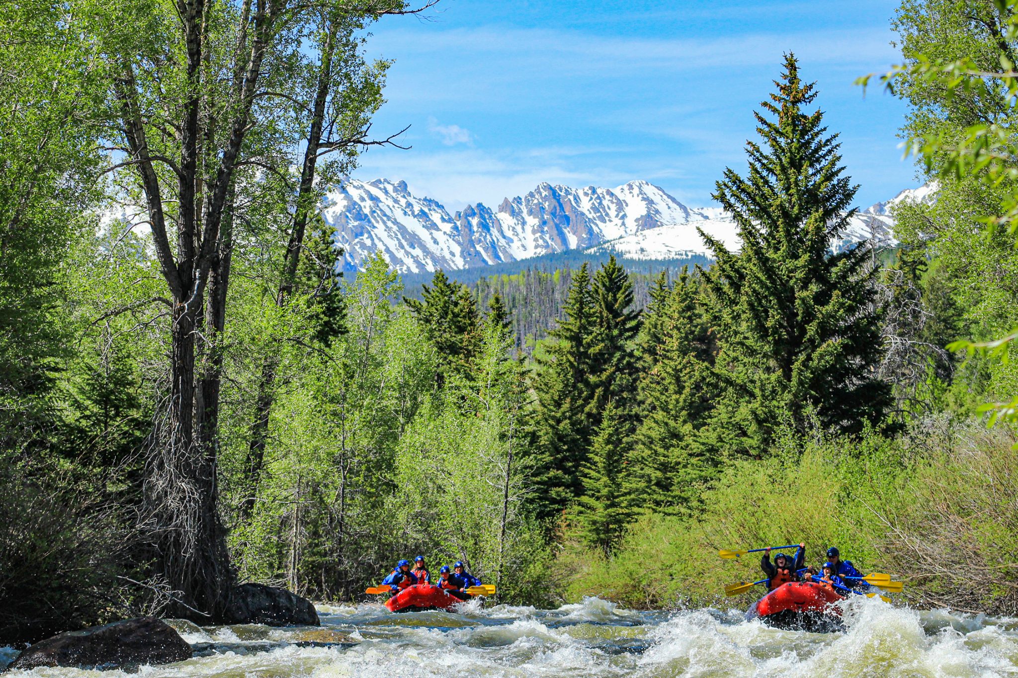
Rafters lift their paddles in the air as they make their way through a series of rapids on the Blue River as the Gore Range rises above the scene. This year is the first weeks-long opportunity to raft down the Blue River since 2019.
Performance Tours Rafting/Courtesy photo
The 23-mile-long pipe that siphons water from Dillon Reservoir to the Front Range has run dry thanks to decreased water demand from the metropolitan areas near Denver.
This has allowed Summit County to keep more than 6,000 acre-feet of water in Dillon Reservoir, and officials with Denver Water, which controls the flows out of the reservoir, say it will help support more recreation on the Lower Blue River.
The outflow to the Blue River currently hovers around 1,050 cubic feet per second. That rate is around 175% of the historic outflow for the last week of June. Last year, outflow was at 56 cubic feet per second, which sits at the historic minimum.
For comparison purposes, a basketball is about one cubic foot. So to put the current flows into perspective, people can imagine 1,050 basketballs flowing past them every second.
Over the next week, the spillway should release flows between 900-1,200 cubic feet per second, and Denver Water forecasts don’t call for the flows dropping below 500 cubic feet per second until mid-July.
As of Monday, June 26, all 10 of Denver Water’s major reservoirs were full, causing free river conditions on the South Platte River.
Multiple swift-water deaths have caused public safety groups to urge caution while recreating on and near rivers. Officials advise folks to never use plastic tubes or vessels that aren’t commercial-grade rafts, and only experienced rafters should attempt to navigate High Country rivers due to their increased flows, natural obstacles and terrain traps.
Denver Water’s collection system via the USACE EIS
LOVELAND, Colorado – The Bureau of Reclamation expects to fill Green Mountain Reservoir in late June, leading to increased flows on the Blue River below Green Mountain Dam and in the Colorado River below the Blue River confluence near Kremmling.
Reclamation will increase Blue River flow below Green Mountain Dam by mid-June. Green Mountain Dam release will increase to approximately 750 cubic feet per second. In addition, Reclamation will discontinue Elliot Creek diversion to reduce spillway releases. Overall, Reclamation anticipates flows in the Blue River below Green Mountain Dam could range from 500 to 1,500 cubic feet per second from mid-June through mid-July.
“Thanks to an abundance of precipitation on the Front Range this spring, cities and irrigators are using less water from transbasin diversions and water managers have prioritized filling east slope reservoirs with water available from rivers on the Front Range,” said Reclamation’s Eastern Colorado Area Manager, Jeffery Rieker. “As a result, many east slope reservoirs have filled, and additional water will remain in the Colorado River.”
Green Mountain Reservoir, a feature of the Colorado-Big Thompson Project, provides stored water for beneficial use within the Colorado River basin upstream of the Gunnison River confluence in Grand Junction, Colorado. Green Mountain Reservoir stores more than 100,000 acre-feet for use by West Slope project beneficiaries. This allocation is commonly referred to as the “Power Pool” and includes the 66,000 acre-foot Historic Users Pool.
Media inquiries or general questions about Reclamation should be directed to Anna Perea, Public Affairs Specialist, at 970-290-1185 or aperea@usbr.gov. If you are deaf, hard of hearing or have a speech disability, please dial 7-1-1 to access telecommunications relay services.
Colorado transmountain diversions via the State Engineer’s office
Click the link to read the article on the Aspen Daily News website (Austin Corona). Here’s an excerpt:
An ongoing water case in Colorado’s Division Five water court in Glenwood Springs could impact a vital source of water for users across the Western Slope. The case developed from a dispute between the Snake River Water District in Summit County and the state’s Division 5 Engineers regarding administration of Green Mountain Reservoir’s Historic User Pool. The case could affect thousands of water users in Colorado’s portion of the Colorado River Basin, including many in the Roaring Fork Valley, who rely on releases from Green Mountain Reservoir. Snake River and the Division 5 Engineers of the Colorado Division of Water Resources disagree on whether Snake River can benefit from water in Green Mountain’s Historic User Pool. Snake River relies on water from the HUP to replace the water it removes from the Snake River system with several wells…
The HUP was created to compensate Western Slope users for water transferred out of the Colorado River Basin to the Front Range. While the HUP itself was only created in 1983, Western Slope water users have been relying on water from Green Mountain since the 1950s. The HUP, along with other allotments of water in the reservoir, were legally designated in order to ensure that Green Mountain would continue as a critical resource for the Western Slope. Snake River is one of thousands of Western Slope water users who rely on the HUP to replace water diverted from the Colorado River and its tributaries.
The Division 5 Engineers challenge Snake River’s ability to benefit from the HUP because Snake River also receives replacement water through an augmentation plan. Augmentation plans are court-approved plans that also replace water diverted by users, but they are not necessarily linked to Green Mountain, and using them is not free. Because Snake River can already replace its diversions during a call with augmentation water, the engineers say it cannot benefit from HUP coverage…Snake River sued the engineers in Colorado’s Division 5 water court in hopes of retaining its HUP benefits. If it loses its HUP coverage, Snake River claims it could cost $800,000 to rely exclusively on its augmentation plan. Snake River argues that coverage from an augmentation plan does not legally disqualify a water user from also being covered by the HUP.
When it comes to supplying water to 1.5 million people, the spring runoff is the most important time of the year for Denver Water.
That’s why having good information about the snowpack is critical. Mountain snow is Denver Water’s primary source of water for its customers.
When the snow that piles up in the mountains over the winter starts to melt, the water flows into rivers and streams that fill storage reservoirs. The spring runoff typically starts at the end of April and wraps up in late June or early July.
But the work to count the snowflakes starts long before that.
“We keep track of the snowpack through measurements on the ground, from the sky and from automated sensors,” said Nathan Elder, water supply manager at Denver Water. “We monitor the snow all winter because it constitutes the majority of our water supply and has major impacts on how we operate.”
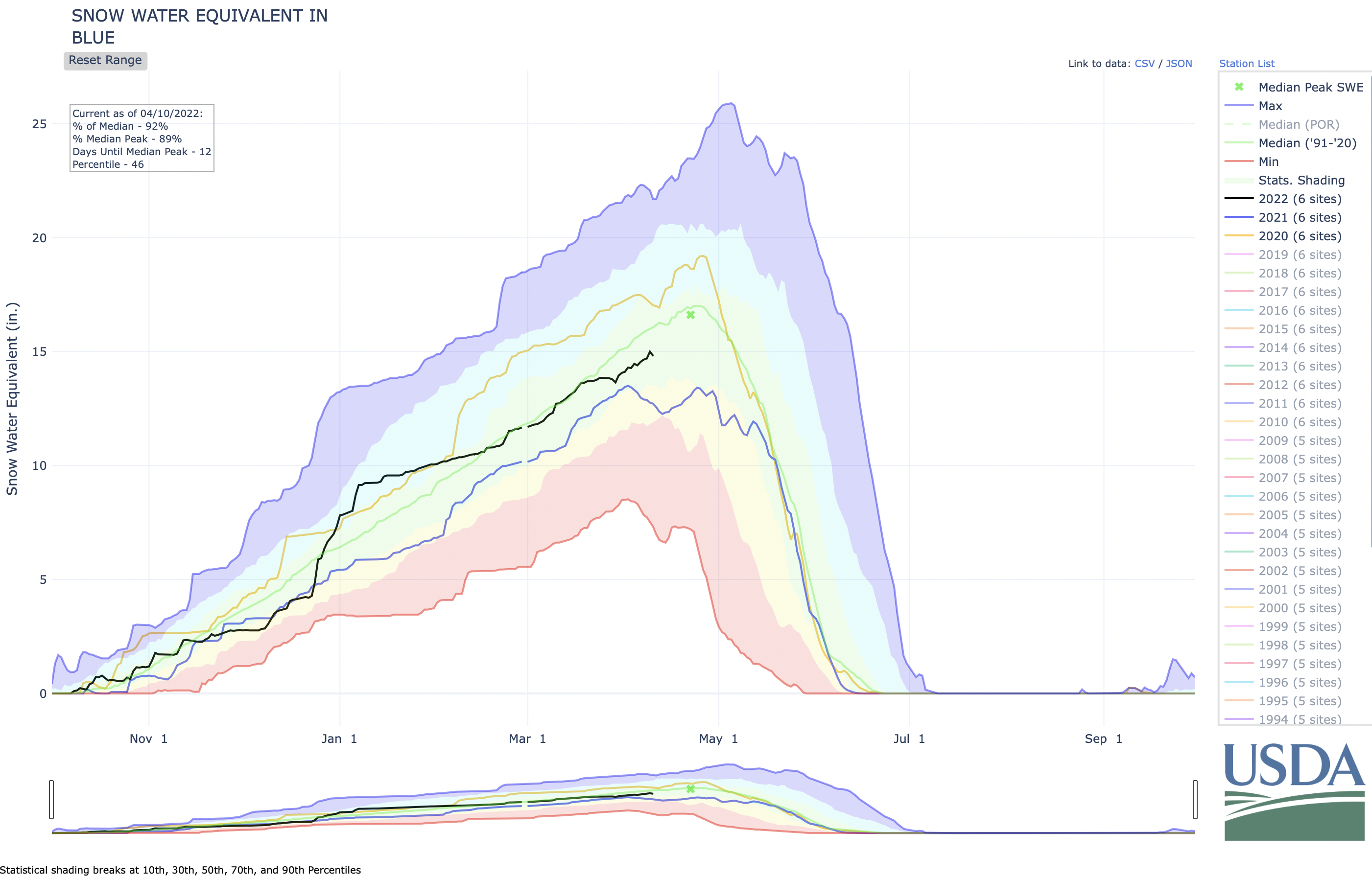
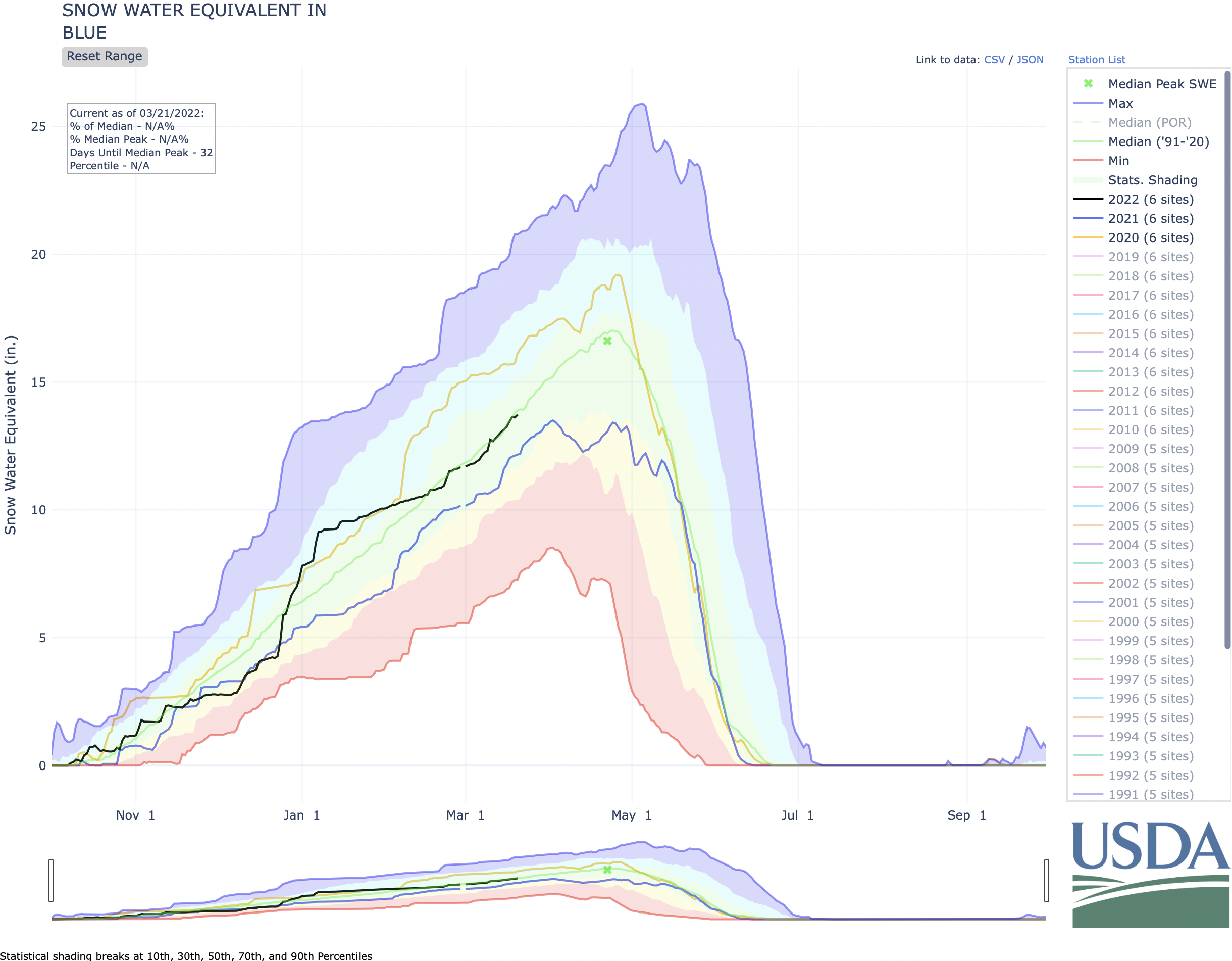
In 2022, the snowpack peaked below average in the areas where Denver Water catches the snowmelt. A below-average snowpack affects the amount of water available to capture and store in the spring.
Denver Water’s collection system via the USACE EIS
“We would like to completely fill our reservoir system every runoff season,” said Elder. “In the years when we don’t hit that mark, it makes following the utility’s annual summer watering rules even more critical for the Denver metro area.”
Watering two days a week should be enough for most landscapes for most of the summer. (Only water a third day, if needed, during periods of extreme heat or dryness.)
Following the summer watering rules will help keep reservoir levels higher, in case next winter’s snowpack is below average.
The Fraser River south of Winter Park on April 29, 2022. The snowpack in the areas where Denver Water captures snowmelt peaked below average for the 2021-2022 winter season. Photo credit: Denver Water.
The snowpack data, reservoir forecasts and customer water use are some of the key factors used to determine if Denver Water might need to impose additional watering restrictions beyond the regular summer watering rules, which run from May 1 through Oct. 1.
Here’s a closer look at the primary ways Denver Water’s planning team keeps track of Colorado’s snowpack.
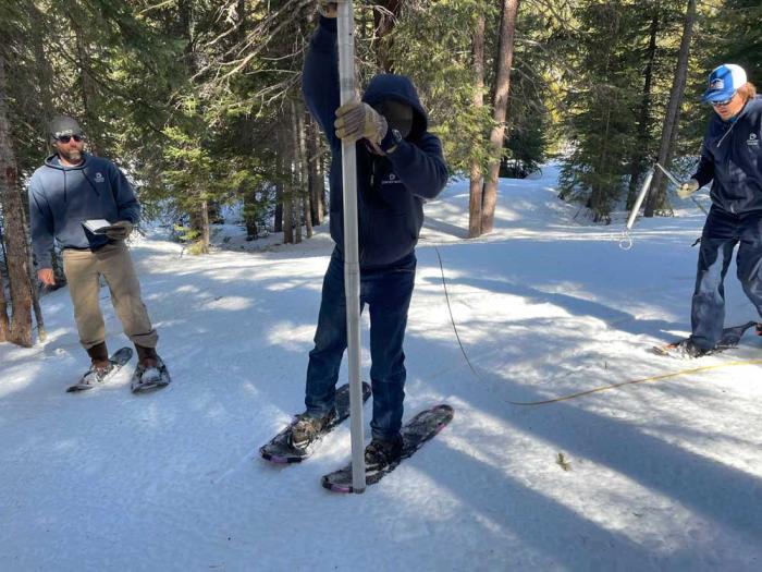
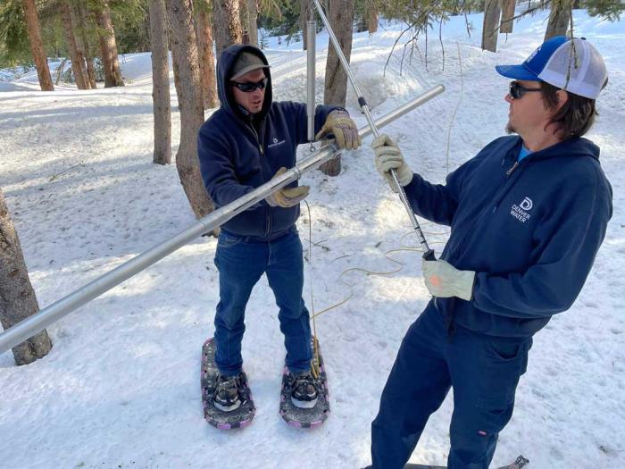
Four times a year from January through April, Denver Water crews strap on boots and snowshoes and sometimes ride snowcats to trek into the forest to measure the snow in Grand, Park and Summit counties, the primary areas where the utility collects its water supply for customers in metro Denver.
Each journey follows a specific, predetermined route called a snow course.
Each snow course has 10 designated stops where workers jab a hollow tube into the snow to capture and weigh a sample of the snowpack.
At each stop, the crew conducts a four-step process:
Collect a sample by dropping the pole into the snow until it hits the ground.
Measure the depth of snow in the tube.
Get the weight of the snow by weighing the snow-filled tube and subtracting the weight of the empty tube.
Calculate the density of the snow using the depth and weight measurements.
Using these measurements, crews calculate the snow water equivalent, or SWE, to determine the water content.
For example, if 10 inches of snow has a density of 10%, the snow water equivalent — the amount of water left behind if those 10 inches of snow melted — is 1 inch of water.
Rob Krueger, facility supervisor for Denver Water, uses a specially designed hollow tube to collect a snow sample near Berthoud Pass. Photo credit: Denver Water.
Denver Water shares the data collected on each snow course with the National Resources Conservation Service, or NRCS. Denver Water is one of 15 agencies that sends people out to collect snow data at 95 locations across Colorado in partnership with the NRCS.
The information helps the agency develop water supply forecasts and monitor snowpack trends over time.
The NRCS’s forecasts are used by water provides, dam operators, farmers, ranchers, recreationists and communities to make important decisions about their water supply.
Denver Water’s Rob Krueger (left) and Adam Clark work out of the utility’s Moffat Collection System office in Winter Park. Here they are weighing a snow sample to calculate how much water it contains. Photo credit: Denver Water.
Silent sentries
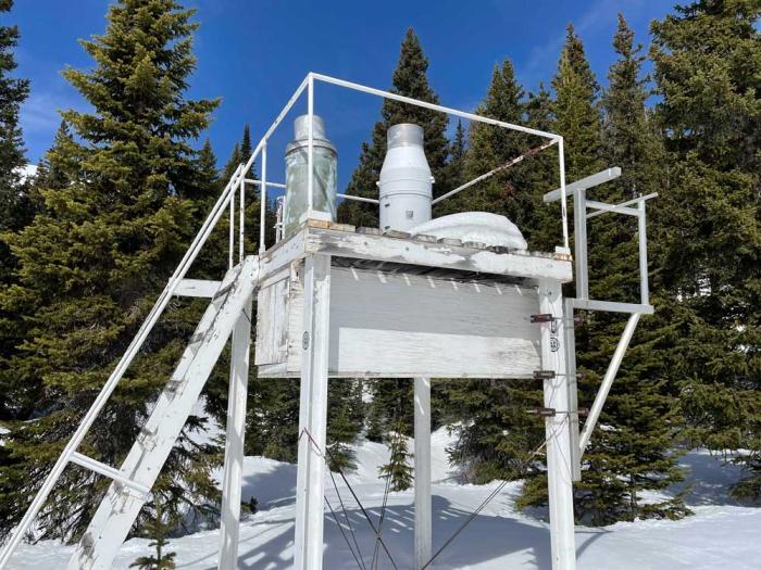
Along with data collected by hand, Denver Water uses information from snow telemetry sites, or SNOTEL, sites during the winter.
SNOTELs, basically automated backcountry weather stations, were first installed in the 1970s and are operated by the NRCS. The federal agency currently has more than 900 SNOTEL sites collecting data in remote, high-elevation mountain watersheds across the western U.S.
At each site, a bladder about the size of a queen-sized waterbed and filled with antifreeze monitors and reports the weight of the snow falling on it, providing information about the water content frozen in the snow. SNOTEL sites send data multiple times per day, although some sensors report hourly.
Denver Water uses information from 13 SNOTELs located in its 4,000 square miles of watershed.
A SNOTEL site on Berthoud Pass in Grand County captures snow measurements throughout the winter. The National Resources Conservation Service manages the SNOTEL sites, which transmit information daily. There are over 900 automated SNOTEL sites across the western U.S. Photo credit: Denver Water.
From the air
Starting in 2019, Denver Water began getting data about the snowpack from the air, using Airborne Snow Observatory planes stuffed with high-tech equipment flying over the snow-covered mountains.
The plane uses beams of light to measure the depth of the snow fields below and capture reflections from the frozen surface. The equipment pings the snow’s surface at up to 10 locations every square meter, and powerful computers crunch reams of data.
The flights provide an assessment of the amount of water frozen in place in the snow across hundreds of square miles that is more accurate than anything Denver Water has ever had before.
“The data we get from the Airborne Snow Observatory flights quantifies all of the snowpack in river basin below, rather than trying to build a picture of the snowpack in basin using just a few selected point measurements we get from the SNOTELs and the snow courses,” said Nathan Elder, Denver Water’s manager of water supply. “Imagine trying to watch a high-definition TV that only has 10 of its thousands of pixels working; you just don’t get the whole picture.”
And in the face of increasingly variable weather patterns related to climate change, having better information and more accurate forecasts of the seasonal runoff will be more important in the future, he said.
The view from an Airborne Snow Observatory plane as it flies over a mountainous region to capture data on the snowpack. Photo credit: Airborne Snow Observatories Inc.
Putting it all together
Elder’s planning team uses data from the snow-measuring methods and combines it with other data such as soil conditions and weather forecasts to determine how much water the winter snowpack will send into Denver Water’s reservoirs.
“Having people hike into the forests to measure the snow by hand is very important for water planners because they give us the ‘boots-on-the-ground’ information we use to verify the data we get from the machines in the SNOTELs and the Airborne Snow Observatory flights,” Elder said.
The forecasts — in turn — help determine how Denver Water will manage the water stored in its reservoirs to meet customer demands in the city and determine if additional water restrictions are needed.
The water supply forecasts are also used to provide information to communities, businesses and other water managers about flooding concerns, water levels for boating on reservoirs, maximizing water rights and how to manage water supplies to benefit the environment.
“Managing water is a very complex business,” Elder said. “The more information and data we can get, the better decisions we can make.”
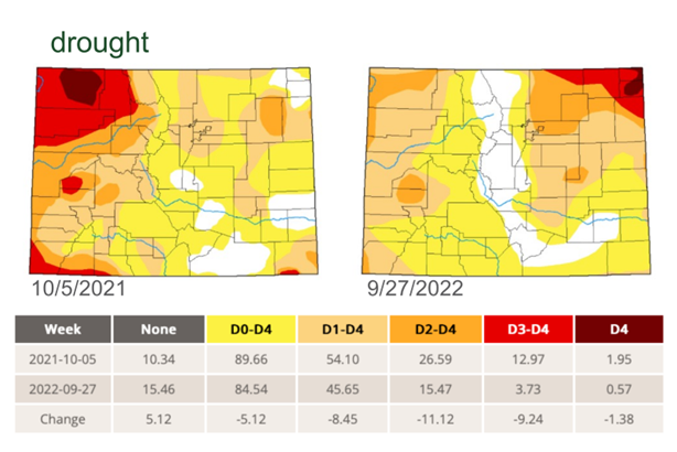
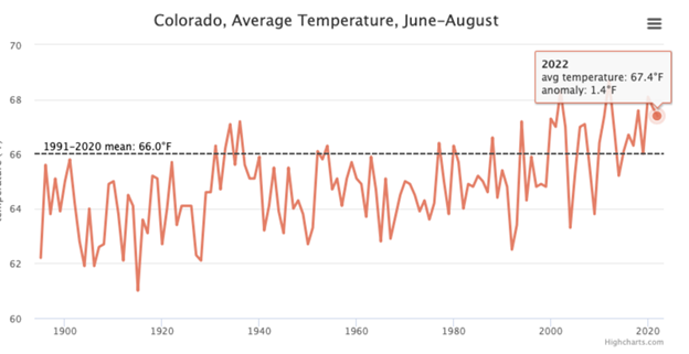
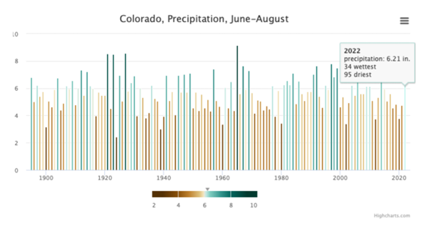
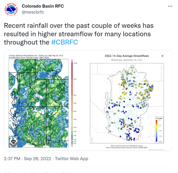
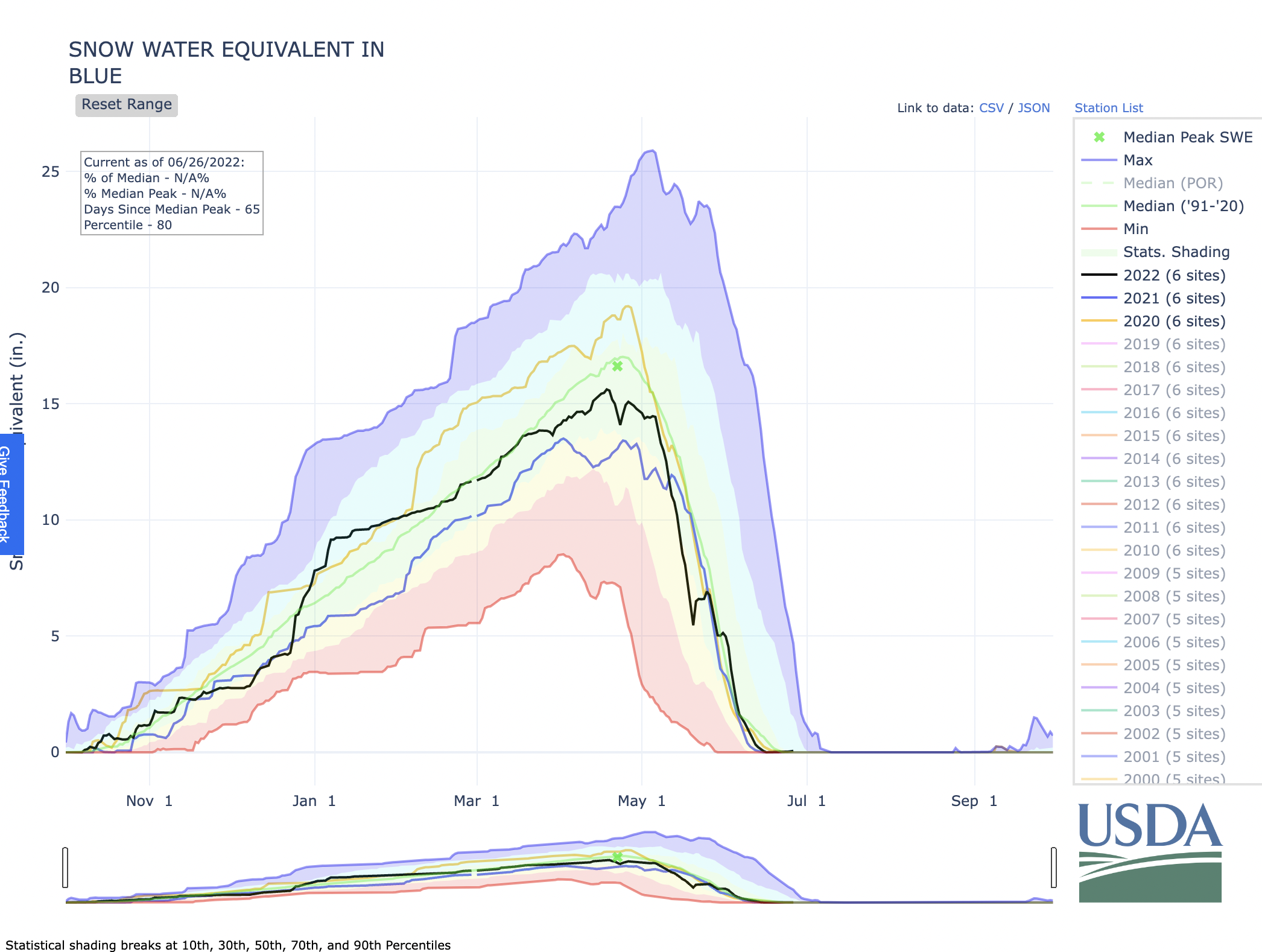
Water Year 2022 started slow, lit up at wintertime, dried up in early spring, leaped back into action in late summer, then got lazy in early fall before one last hurrah.
The erratic spurts over the just-completed “water year,” the 12-month span between Oct. 1 and Sept. 30 that hydrologists use to track water trends, added up to a not-terrible-but-not-great-either result for Denver Water.
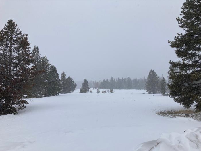
The Blue River, which flows into Dillon Reservoir, Denver Water’s largest reservoir, in April 2022. Photo credit: Denver Water.
The most noticeable events included a very slow start to mountain snowfall through the first three months (bad), a second straight year of healthy summer monsoons in the mountains (good) and a sizable split between the water fortunes of Denver Water’s collection area (the high country and foothills) versus its service area (Denver and parts of five surrounding counties).
In short, it translated into a reasonably good water year in higher elevations and a far drier one for the 1.5 million people the utility serves in Denver and nearby suburbs.
One memorable result? Denver’s first snowfall came Dec. 10 — the latest first snow on record for Denver.
“Every water year is different, and Mother Nature throws new challenges at us almost every time,” said Nathan Elder, Denver Water’s manager of water supply. “But timely rains and good customer practices helped us keep reservoir levels in solid shape and we soldiered through an up-and-down year.”
The very best news appears to be the way a second consecutive year of strong monsoon rains and higher humidity replenished dry soils in the mountains.
Should Colorado enjoy a deeper winter snowpack this year, it would mean more melting snow in the spring could find its way to streams and reservoirs in 2023, rather than vanishing into parched soils as has been the case in recent cycles.
Dice up the numbers in a different way and zoom out from Denver Water and the picture looked better from a statewide perspective, with summer precipitation levels the best since 2015.
Precipitation statewide left much of Colorado in less severe categories of drought than the end of the 2022 water year. Most of Denver Water’s collection system finished the water year out of drought or classified as “abnormally dry,” the lowest classification. Image credit: U.S. Drought Monitor; Colorado Climate Center.
Additionally, soil moisture is at its highest levels in three years, according to climate trackers at Colorado State University and the U.S. Department of Agriculture’s Natural Resources Conservation Service via recent reporting from Marianne Goodland in the Denver Gazette.
While those are positive developments, experts across various agencies agree that Colorado and its water utilities need a string of strong winters, and preferably some wetter/cooler years overall if we’re ever to see longer-term improvements in hydrology.
But in an era of steady climate change that appears to be unlikely. Colorado’s summer of 2022 was the sixth warmest in the 128-year record maintained by state climatologists.
Denver Water’s supply managers faced some tough conditions in the 2022 water year.
Colorado’s summer of 2022 was the sixth warmest in the 128-year record. It was also the second warmest for minimum temperatures, just behind the summer of 2012. Image credit: Colorado Climate Center.
Ongoing work to expand capacity at Gross Reservoir has limited storage in the facility west of Boulder. At the same time, unusually dry conditions on the South Platte River downstream of Denver left farmers calling on water rights dating all the way back to 1871 (just a decade shy of the oldest water rights on the river).
These rights are senior to all of Denver Water’s South Platte River reservoirs and made it difficult to fill those reservoirs. Cheesman Reservoir’s 1889 right is the most senior storage right in Denver Water’s portfolio.
All of that meant more water bypassed Denver Water’s reservoirs to meet those agricultural calls and there was less ability to make up that water by pulling from Gross Reservoir on the north side of the utility’s system. It also meant higher-than-average flows through the Roberts Tunnel to help supplement South Platte supplies.
Colorado’s summer of 2022 was the 34th-wettest summer in the 127-year record, and 0.56 above average. It was the first above-average summer for rainfall since 2015. Image credit: Colorado Climate Center.
But, in a hat tip to customers and Mother Nature, smart irrigation techniques (like turning off systems in rainy periods) and solid summer precipitation in the higher country (and, at times, in metro Denver) helped keep Denver Water’s reservoirs at just below average levels.
In fact, all that combined to close a storage gap. Reservoirs were 5% below average in July. But by the end of September that deficit fell to just 1% below average.
And there was more good news. Another good summer of monsoons kept wildfires at bay, which was a big relief after the devastating water year of 2020, when record-setting late-season fires extended the burn season into October.
The last month of summer keeps getting warmer. This one set a new record for 90-degree days (10), which — along with other factors — make it the fastest-warming month in the Denver area when compared to the previous 30-year block of records that spans 1981 to 2010.
Conditions improved in late September, when late-season moisture boosted streamflows and dampened soils, especially in the high country, bringing a happy ending to the water year.
After another hot start to September, the unseasonably dry and hot weather gave way to helpful rainfall in Colorado and across the Colorado River Basin, seen in these maps from the National Weather Service’s Colorado Basin River Forecast Center. Tweet credit: Colorado Basin RFC.
Some broader context also is in order.
The 2022 Water Year for the wider Colorado River Basin was another poor one. One simple metric captures the status of the basin: The amount of water in the two major reservoirs on the river dropped dramatically, with Lake Mead falling 1.8 million acre-feet from a year ago and Lake Powell falling 1.5 million acre-feet in the same time frame.
Trends in the Colorado River Basin matter a great deal to Denver Water, as the utility gets about 50% of its supplies from the headwaters of the basin.
Westwide SNOTEL basin-filled map November 13, 2022 via the NRCS.
The new 2023 Water Year that began Oct. 1 is off to a good start for Denver Water.
After the nip-and-tuck of the summer months, the utility’s reservoir levels have hit their average mark heading into late fall and winter, just where water managers want to be at the beginning of the snow-accumulation season.
“We hope Mother Nature makes a New Water Year Resolution to provide ample snow and rain fall in the water year of 2023,” said Elder.
It’s he and his team who must now begin planning for the various scenarios winter and spring might bring.
You, too, can make a resolution for the New Water Year: to reduce your water use. Check out Denver Water’s website for rebates and ways to use water efficiently.
Click the link to read the article on the Summit Daily website. Here’s an excerpt:
Thanks to recent snow storms in the mountains, the Blue River watershed remains above the 30-year median, and the Colorado River headwaters have had the best start to the water year since the fall of 2019. According to data from the Natural Resources Conservation Service, the Blue River currently has about 1.9 inches of snow-water equivalent — about half an inch above the median. Snow began to fall in Summit County on Thursday and continued into the weekend, bringing more inches of snow to ski areas and communities in the county.
Over the weekend, OpenSnow reported that about 6 inches fell at Loveland Ski Area, and 5 inches was recorded for Copper Mountain Resort. About 4 inches fell at Arapahoe Basin Ski Area, and another 4 inches fell at Breckenridge Ski Resort. Just over 2 inches fell at Keystone Resort.
Across the headwaters, Natural Resources Conservation Service data shows that the Colorado River is at 129% of the 30-year median. Currently, that is better than the past two water years. Last year, snow water equivalent was at about 1.7 inches, and in 2020, the headwaters had a very slow start, totaling below 1 inch by the beginning of November.
Westwide SNOTEL basin-filled map November 11, 2022 via the NRCS.
As the first installment of the Summit County government’s new County 101 series, community members gathered to hear from local water leaders about the state of the Colorado River drought and how it affects local headwaters. Representatives from the Colorado District, Colorado Division of Water Resources, Blue River Watershed Group and High Country Conservation Center gave presentations about local waters and how community members can understand recent reporting about drought across the river basin…
On Oct. 12, the Biden administration designated at least $500 million from the Inflation Reduction Act to go toward the Upper Colorado River Basin, which includes Colorado, for “investments in conservation and long-term system efficiency,” according to a release from the White House.
Brad Udall: Here’s the latest version of my 4-Panel plot thru Water Year (Oct-Sep) of 2021 of the Colorado River big reservoirs, natural flows, precipitation, and temperature. Data (PRISM) goes back or 1906 (or 1935 for reservoirs.) This updates previous work with @GreatLakesPeck. Credit: Brad Udall via Twitter
“(Drought and climate change are) something here in the headwaters we live with — our hydrology. We see it happening. We see less snow. We see the dry soils that are absorbing what runoff we do have,” said Marielle Cowdin, director of public relations at the Colorado River District. “For every 1 degree Fahrenheit rise in average temperature, stream flow is reduced between 3% to 9%, with most studies actually leaning toward that 9%.”
Like other parts of the Upper Colorado River Basin, the Blue River has faced changes in the past decade as a result of climate. This includes less snowpack for spring runoff, drier soils and warmer summer temperatures.
“It’s my belief that these bigger-picture issues that are brought up and that we’re all facing, they’re coming down the pike,” Troy Wineland, water commissioner for Summit County, said. “And believe me, they’re coming. We’ve got two of the largest reservoirs in the country sitting about 24% capacity. If that’s not the kind of writing on the walls, I don’t know what it is. So outreach and education to me is critical.”
Summit County announced the kickoff of its public series, County 101, with a panel discussion titled “Understanding Colorado’s Water Challenges,” taking place on October 11th at the Summit County Community and Senior Center in Frisco.
“Our goal with County 101 is to keep us connected to our community and help bring more understanding to issues that are important to our residents but often fly under the radar,” said Summit County Commissioner Joshua Blanchard.
The County 101 series will be combination of in-person discussions and online events open to the public.
The first event’s panel discussion includes several experts in water resource management, including the Colorado River Water District, Blue River Watershed Group, and High Country Conservation Center.
“Water is a complex subject involving several agencies and organizations, yet it’s our lifeblood,” said Blanchard. “I’m really looking forward to this panel of experts to help our community understand how our Summit County contributes to and is impacted by the challenge of maintaining this critical resource.”
The community is invited to bring questions for the panel, and refreshments will be provided.
Click the link to read the article on the Summit Daily News website (Eili Wright). Here’s an excerpt:
The southern half of Summit County has been lifted from drought status as of the morning of Sept. 6., according to the U.S. Drought Monitor. The line begins just south of Ute Peak, stretches along Interstate 70 and ends around Chalk Mountain, a Lake County landmark slightly south of the Summit County border. A quick glance at the map shows the boundary between the southern area of the county that is out of drought and the northern half of the county is only “abnormally dry” a slightly curved, vertical line that encapsulates every town south of Silverthorne…
US Drought Monitor Colorado Map September 17, 2013
Summit County was last relieved from a drought in the spring of 2019, ending in the spring of 2020. The last time a drought was lifted in the fall was in 2013…This summer’s monsoonal rains are what changed the tide. Precipitation levels at Hoosier Pass, south of Breckenridge received the “second wettest June through August” on record, [Peter] Goble reported. The difference was the prolonged and spread out nature of this summer’s monsoonal rains, said Rocky Mountain Area Coordination Center wildland fire meteorologist Valerie Meyers. The consistency of the rains gave the county a chance to catch up on moisture from last summer, she added.
Some of the snowmelt flowing in the Blue River as it joins the Colorado River near Kremmling, Colo., will reach the Lower Basin states. Dec. 3, 2019. Credit: Mitch Tobin, the Water Desk
Click the link to read the article on the Summit Daily website (Eliza Noe). Here’s an excerpt:
The plan focuses on four “interconnected action areas,” including resiliency planning, thriving watersheds, robust agriculture and community. It describes 50 “partner actions,” or project ideas that could be supported by Water Plan grants, as well as 50 “agency actions,” to support local projects, conservation and wise-water development. Overall, however, basin roundtables and stakeholders identified more than 1,800 potential future projects statewide, and 321 are in the Colorado Basin with 36 being in Summit County. In total, over $20 billion would be spent on the projects by 2050. Russ Sands, senior program manager of water supply planning for the Colorado Water Conservation Board, said that projects in the database are designated as near-term, midterm or long-term when it comes to getting them done. They’re also not all infrastructure projects. Some may work toward water conservation and others may be educational projects or environmental…
According to the plan, the Colorado Basin — which includes Summit County and the Blue River — faces issues such as competing resources for agriculture, tourism, protection of endangered species and potential for Colorado River Compact administration. The basin encompasses about 6% of the state’s population, and between 2015 and 2050, population is expected to increase 48-88%. Flows are also projected to be variable over the next several decades. Decreased peak flows across the basin create risks for wetland plants and fish habitats. Instream flows and recreational in-channel diversions may not be met if summer flows decrease due to climate change. Each year, water providers in the South Platte and Arkansas Basins export approximately 480,000 acre-feet each year from the Colorado Basin for eastern slope agricultural, municipal and industrial uses. Across the basin, as much as 70% of the river’s water flows out of Colorado…
The pie chart shows how much water each sector uses in Colorado, as well as how much water originating here leaves the state. CREDIT: COURTESY COLORADO WATER PLAN
“(June 30) opens up the 90-day public comment period,” Rebecca Mitchell, director of the Colorado Water Conservation Board, said. “This updated new and improved Water Plan is designed to meet today’s water challenges and builds on the legacy that we have in Colorado of collaborative statewide water planning.
If yes, then you’re familiar with Denver Water’s decadelong campaign, launched a few years after the 2002 drought, that urged customers to reduce the amount of water they used in their everyday lives.
Denver Water’s decadelong Use Only What You Need campaign found humor in conservation. Photo credit: Denver Water.
The occasionally cheeky campaign showcased images like a park bench with only room for one person, water from a broken sprinkler head cascading onto a giant billboard and suggestions for using less water — like showering with a friend.
And it worked. By the time the campaign — created by Denver’s Sukle Advertising & Design — ended in 2015, water use by Denver Water’s customers had dropped 22% compared to usage before the drought.
The “Use Only What You Need” campaign has been recognized repeatedly over the years for its effectiveness and memorability, and on May 17 the Out of Home Advertising Association of America inducted it into the OBIE Hall of Fame, a group dominated by advertising campaigns backed by national and international brand names.
“Denver Water’s signature orange box asking customers to ‘Use Only What You Need’ became advertising legend in the Denver metro area,” said Jim Lochhead, Denver Water CEO/Manager.
“In a light-hearted and at times outrageous way, the campaign led the charge for our conservation programing where we had a critical call to action: Reduce water use by 22%. Eight years after achieving that goal, Use Only What You Need has remained a one-of-a-kind catchphrase that has continued to help Coloradans embrace a culture of conservation, which is so vital in the arid West where water is such a precious resource.”
Tip for using less water? Showering with a friend was part of a conservation campaign that reduced water use among Denver Water customers by 22% compared to usage before 2002. Photo credit: Denver Water.
Out-of-home advertising is visual advertising outside of the home, such as billboards, indoor and outdoor signs, ads on bus shelters or benches, in airports or train stations, and in a stadium or movie theater.
Previous OBIE Hall of Fame winners include the insurance company Geico (2021), entertainment giants The Walt Disney Co. (2007) and Universal Studios (2019), brewer MillerCoors (2018) and technology company Apple Inc. (2005).
Competition for the 2022 Hall of Fame award put Denver Water up against international heavyweights — and household names — Google, Netflix, Procter & Gamble Co., Pepsi and Samsung.
In the 30-year history of the OBIE Hall of Fame awards, Denver Water’s award is only the second time a regional brand has won the judges’ nod. The first was the San Diego Zoo in 1995.
“This is one of the highest creative honors in our industry, and we are immensely proud to be recognized by OAAA and our peers,” said Mike Sukle, owner of Sukle Advertising & Design.
“Creating and managing the campaign for a decade shaped how we approach every campaign we create. It cemented our philosophy that work must be both smart and creative to generate exceptional results. And while mass media including out of home was critical, the campaign spread almost as much through word-of-mouth. Our audience became our media. That’s an important lesson for all brands. And if you can make people like you, they may also listen to you,” he said.
The campaign encouraged customers to take a hard look at how much water they — and their lawns — truly needed. Photo credit: Denver Water.
Anna Bager, president and CEO of the association, called Denver Water’s campaign “truly brilliant and entertaining.”
“Denver Water has achieved legendary out-of-home status with a sustained level of creative excellence over many years. Their commitment to the ‘Use Only What You Need’ headline came to life in a seemingly endless number of creative solutions,” she said.
And while Denver Water’s message that water is precious and should be used wisely hasn’t changed, the utility’s campaign around water has evolved into a simple main message: Water is everything.
Denver Water’s latest campaign focuses on what water brings to our lives under the tagline “Life Is Better With Water.” Image credit: Denver Water.
Using the tagline “Life Is Better With Water,” the utility’s current campaign with Denver advertising agency Pure Brand celebrates the importance of water as a precious resource in our everyday lives and one that plays a vital role in Colorado’s unique lifestyle.
“It’s about elevating the value of water in our daily lives. Together, we all can help create a ripple effect that ensures our Colorado lifestyle continues for generations to come,” said Kathie Dudas, manager of brand and marketing at Denver Water.
Some of the snowmelt flowing in the Blue River as it joins the Colorado River near Kremmling, Colo., will reach the Lower Basin states. Dec. 3, 2019. Credit: Mitch Tobin, the Water Desk
Click the link to read the article on the Summit Daily website (Eliza Noe). Here’s an excerpt:
Data from the National Resources Conservation Service shows that snowpack sensor sites measured zero inches starting on June 17. The 30-year median was just above that level on that date, 0.4 inches, and the median shows a completion of snow melt by June 22.
In recent weeks, this year’s snow-water equivalent levels stayed on par with the median after a late-May snow boosted levels back up from being several inches below. Before that, snow-water equivalent had fallen behind the median.
On May 20, just before the spring snowstorm, the Blue River basin had just 5.5 inches left, almost half of what was charted for the median, 10.2 inches. By May 28, snowmelt had begun to match that of the median again.
Click the link to read the article on the News on Tap website (Todd Hartman):
With the 2021-22 snow season winding down, Denver Water is getting a clearer look at water supplies approaching the irrigation, gardening and summer recreation season.
In fact, as 9News meteorologist Cory Reppenhagen has pointed out, much of Colorado likely hit its peak snowpack in late March, meaning we’ve started the process of spring runoff, when the snowpack begins to melt and flow into streams, rivers and reservoirs.
(Caption: Watch Denver Water crews weigh the snow to find out how much water it contains.)
In Denver Water’s collection system, which includes parts of the South Platte River and Colorado River basins, it’s not fully certain we’ve hit our peak — the point when snowpack reaches its highest point before melting off.
But we’re surely close, as snowpack in Denver Water’s collection system typically peaks around April 20.
What’s it all mean for our water supply? It’s a mixed picture.
Snowpack is a bit below average, but soil moisture has improved compared to last year, meaning more melting snow will find its way to reservoirs and less will disappear into thirsty ground.
Denver Water’s reservoirs are 79% full, on average, which is normal for this period. And runoff is likely to push that number north of 90% when storage peaks midsummer.
A mid-April snowstorm delivered several inches of snow to Colorado’s high country. Photo credit: Denver Water.
“Overall, we’d like the numbers to be higher, but with better soil moisture we expect better runoff than in recent years with similar snowpack,” said Nathan Elder, manager of water supply for Denver Water.
“We have good carry-over storage going into the runoff season because of low winter water use,” he added. “That’s a reflection of good work from our customers in continuing to improve indoor efficiency and water use habits.”
It’s important those good habits extend into the watering season; customers with spring fever should try not to get ahead of things with outdoor irrigation.
Warning! April is too early to turn on hoses, sprinklers and irrigation systems.
A string of snowstorms this year has improved soil moisture in the Denver region. And more storms could still head our way in late April and early May. This time of year, the weather can be unpredictable, and you might think spring has sprung — only to have winter sweep back in for a last goodbye.
And planting ahead of Mother’s Day (May 8 this year) is always a gamble, as the potential overnight freezes still lurk into the early days of the month. Cold temperatures can put an early end to spring seedlings and damage irrigation systems if water inside the piping freezes.
As it stands in mid-April, snowpack is at 88% of average in Denver Water’s Colorado River collection system, and at 74% of average in its South Platte system, though that South Platte figure is affected by a single tracking location with poor snow that has pulled down the broader average; in the wider South Platte River basin, snowpack is currently 90% of normal.
Don’t turn on your sprinklers yet. Late spring snowstorms can easily damage irrigation systems. Photo credit: Denver Water.
And a big wet storm or two, still possible this time of year, would improve the outlook.
Additionally, planned Airborne Snow Observatories (ASO) flights, which measure high elevation snowpack with great precision, will bring additional insight into the snowpack, as well as adjustment to the runoff outlook.
In 2019, flights in the Blue River Basin above Dillon Reservoir revealed more snow than expected at elevations above traditional snow telemetry sites that provide most snowpack data.
“The ASO data gives us the most detailed and accurate insight into snowpack,” said Taylor Winchell, a climate change specialist at Denver Water. “We look forward to seeing what new information that tells us this spring and how it narrows the uncertainty of water supply forecasts.”
According to the latest data from the Natural Resources Conservation Service, the snow water equivalent of the Blue River was at 92% of the median, dipping slightly since Summit County had heavy snowfall in early March. This means that, so far, there are 13.7 inches of snowpack in the area. The 30-year median level for the same date is 14.7 inches, but this week’s expected snowfall is likely to push those levels closer to the median…
The Blue River Basin is still several weeks out from the median peak, which usually hits its crest on or around April 25. By that time, the basin usually has between 16.5 and 17 inches. This time last year — a particularly dry year across the Western Slope — the basin was already at its peak by the end of March. The most snow that had accumulated in 2021 was 13.5 inches, causing a dramatic drop throughout April and May.
Colorado snowpack basin-filled map March 20, 2022 via the NRCS.
Click the link to read a snowpack article on the Summit Daily website (Eliza Noe). Here’s an excerpt:
Last week’s snowfall has finally pushed local river basins to over the average median, a level that water experts have been following for months into this water year, which runs from October through September.
According to data from the National Resource Conservation Service, the Blue River Basin was steadily on par with its median over the last 10 days. Last week, the basin had been almost exactly along the median before dipping very slightly by Sunday, March 20.
Sunday’s most recent data shows that current levels have a snow-water equivalent of 13.7 inches, whereas the 30-year median is 13.9 inches. This puts the Blue River Basin at 99% of the median at this point in the year and 83% of the median’s peak. The median’s peak is set to crest on April 27, so it is possible that future snowfalls in coming weeks could keep the basin’s trajectory on track.
Westwide SNOTEL basin-filled map March 20, 2022 via the NRCS.
Click the link to read “Colorado snowpack 100% of median Friday ahead of next week’s storm” on TheDenverChannel.com website (Blair Miller). Here’s an excerpt:
Colorado’s snowpack sat at 100% of median Friday after this week’s snowstorm and ahead of another storm that will bring snow to the state on Monday, though forecast models are still showing wide variations in how much snow will fall. The snowpack has increased fairly steadily over the past two weeks after a dry period at the end of January and beginning of March. The foothills west of Denver and Boulder saw the most snow in this week’s storm, but other areas of the state saw a few inches as well…
All eight of the state’s river basins were above 90% median snowpack levels as of Friday. The Gunnison basin (112% of median) had the most robust snowpack, followed by the San Miguel, Dolores, Animas and San Juan (104% of median), the Upper Colorado Headwaters (104% of median), Upper Rio Grande (101% of median), and South Platte (101% of median) basins. The Laramie and North Platte (99% of median), Arkansas (96% of median), and Yampa and White (91% of median) basins were all slightly below median levels…
Colorado Drought Monitor map March 15, 2022.
While the snowpack is at 100%, Colorado’s drought remains relatively unchanged again this week. Ninety-two percent of Colorado is experiencing moderate or worse drought. Fifty-seven percent of the state, mostly along the eastern plains, is experiencing severe drought or worse. And about 8% of the state – mostly along the southern border with New Mexico – is experiencing extreme or exceptional drought conditions, according to the U.S. Drought Monitor.
Expanding the reservoir requires raising the dam 131 feet by placing new concrete on the existing structure. Image credit: Denver Water.
Click the link to read the article from Denver Water (Todd Hartman):
After nearly two decades of planning and permitting, Denver Water’s work to expand Gross Reservoir northwest of Denver is set to kick off.
Over the coming weeks, residents living near the reservoir may notice early signs of construction activity, including limited tree removal, more heavy equipment on roadways and shifts in recreation access to the reservoir.
“We want residents and visitors to the area to be aware and informed; we are taking the initial steps on the project, including mobilization of equipment, in the weeks to come,” said Jeff Martin, the program manager for the expansion project.
“We want to be transparent about the work underway and we want to share information proactively while continuing to address questions and respond to concerns our neighbors have shared. Most importantly, we want to ensure everyone’s safety on the roadways.”
A consistent place to get up-to-date information on the expansion project will be through the project website http://grossreservoir.org as well as via a Google My Map.
The public also can contact Denver Water through email, a phone hotline and virtual office hours, as well as by signing up for email updates and following the utility’s social media channels. Those contact details also are available on the project website and at http://denverwater.org.
Denver Water also held public outreach sessions in February for residents living in the vicinity of the project. About 80 neighbors attended to learn more about what to expect as construction ramps up.
Raising the existing Gross Dam and expanding the reservoir will improve water reliability for more than 1.5 million people. Image credit: Denver Water.
Here are some key things to expect in the coming weeks and months. In many cases, specific start dates for work are still being developed. Those will be shared at http://grossreservoir.org as details are finalized.
Improvements to Gross Dam Road. To protect the safety of all drivers, Denver Water is widening the road in various sections to address tight curves as well as improving the intersection at State Highway 72 and Gross Dam Road. Signage and traffic control will be in place to help drivers safely navigate the affected areas.
Improving the intersection of State Highway 72 and Gross Dam Road will improve safety for all drivers. Image credit: Denver Water.
Limited tree removal. Some trees will be removed in areas planned for site development on the south side of the dam, at the future quarry location, in areas along Gross Dam Road and other areas where various construction activities are planned.
Equipment mobilization. Trucks and other heavy equipment will be spotted more frequently on Highway 72 and nearby roads as contractors position materials for upcoming work on roads and near the base of the dam.
Denver Water is committed to ensuring materials are delivered safely to the project site. Image credit: Denver Water.
Recreation changes. Access to recreation areas on the south side of the dam, including Windy Point, Osprey Point and Miramonte Picnic Area, will be closed in mid-March. Public boat launch access will be relocated from Osprey Point to the North Shore peninsula. This Google My Map is a good place to check for up-to-date information on recreation and access.
Access to the North Shore of the reservoir will also be limited temporarily this spring for construction of a temporary parking lot to help accommodate recreation shifts during the expansion project.
Recreation access will change during the expansion project, this Google My Map is a good place to check for up-to-date information. Image credit: Denver Water.
Construction activities will increase as the weather warms.
By this summer, truck trips in the canyon are expected to increase to nearly 20 trips per day and the workforce will grow to roughly 300 people, though a ridesharing program will help reduce traffic impacts. That intensity will drop off again as the weather cools.
“We recognize this project will have disruptions to the community near the project and within Coal Creek Canyon,” Martin said. “We are committed to clear, two-way communication with the public and keeping people fully informed as we move forward on this critical project.”
Since its formation more than 100 years ago, Denver Water has always planned ahead when investing in the system that today supplies clean, safe drinking water every day to a quarter of Colorado’s population.
And with a variety of changes — from regulations to weather patterns — expected in the future, the utility and its 1,000 employees are continuing the work needed to maintain, repair, protect and upgrade its 4,000 square miles of watershed and 3,000 miles of pipe, plus its dams, pump stations and underground storage tanks and more.
Denver Water delivers safe, clean water to 1.5 million people every day, 25% of Colorado’s population. Photo credit: Denver Water.
While the global COVID-19 pandemic has added another layer of complexity, Denver Water has worked to keep rate increases for customers as small as possible.
On Oct. 27, the Denver Board of Water Commissioners adopted new water rates that will effective Jan. 1, 2022, to help pay for critical upgrades and projects to keep this system operating efficiently. How that rate increase will affect individual customer bills will vary depending on where the customer lives in Denver Water’s service area and how much water they use.
For typical single-family residential customers who receive a bill from Denver Water, if they use 104,000 gallons of water in 2022 as they did in 2021, the new rates will increase their monthly bill by a range of about 47 cents to $1.34 depending on where they live.
“Denver Water’s mission is to ensure that we deliver safe, clean water to the people who rely on us every day,” said CEO/Manager Jim Lochhead. “Over the next 10 years, we are forecasting an estimated investment of $2.6 billion into our system to increase its resiliency, reliability and sustainability in the face of changes we are anticipating. From more frequent droughts and wildfires to additional regulations we expect we will be asked to meet — we will be prepared.”
A helicopter collects water from Dillon Reservoir during efforts to contain the Ptarmigan Fire near Silverthorne, Colorado, in late September. Photo credit: John Baker, safety specialist at Denver Water.
A customer’s monthly bill is comprised of a fixed charge, which helps ensure Denver Water has a more stable revenue stream to continue the necessary water system upgrades to ensure reliable water service, and a volume rate for the amount of water used.
The fixed monthly charge — which is tied to the size of the meter — is increasing by 74 cents in 2022 for most single-family residential customers to ensure Denver Water is recovering 20% of its needed revenue from fixed charges.
After the fixed monthly charge, Denver Water’s rate structure has three tiers based on the amount of water used.
“Even with such large efforts in our future, it’s our goal to have slow and steady rate increases with even, annual adjustments that allow our customers to plan ahead and avoid rate shocks,” said Fletcher Davis, rates manager for Denver Water.
To keep water affordable, the first tier, which covers essential indoor water use for bathing, cooking and flushing toilets, is charged at the lowest rate.
The amount of water in this first tier is determined for each customer by averaging their monthly water use as listed on bills dated January through March each year. This is called their average winter consumption.
Water use above the average winter consumption — typically used for outdoor watering — is charged at a higher price. Efficient outdoor water use is charged in the second tier (middle rate), followed by additional outdoor water use in the third tier (highest rate).
Meet customers who used Garden In A Box, a Resource Central program supported by Denver Water, to beautify their landscapes with water-wise plants.
The difference in volume rates for customers who live inside Denver compared to those who live in the suburbs is due to the Denver City Charter, which was changed in 1959 to allow permanent leases of water to suburban water districts based on two conditions: 1) there always would be an adequate supply for the citizens of Denver, and 2) suburban customers pay the full cost of service, plus an additional amount.
Denver Water encourages customers to be efficient with their water use.
Using less water means more water can be kept in the mountain reservoirs, rivers and streams that fish live in, and Coloradans enjoy. And using less water also can lower your monthly water bills, saving money.
“We are continuing our work maintaining and replacing water mains in the street, building a new state-of-the-art treatment plant and water quality laboratory, preparing for the needed expansion of Gross Reservoir and replacing old, customer-owned lead service lines to protect our customers from the risk of lead in drinking water,” Lochhead said.
“At the same time, we use the tools available to us to help pay for the necessary investment in our system and keep our rates as low as possible.”
In addition to rates paid by customers, Denver Water relies on bond sales, cash reserves, hydropower sales and the fees paid when new homes and buildings are connected to the system.
The utility does not make a profit or receive tax dollars. It reinvests money from customer water bills to maintain and upgrade the water system.
Managing water collected from the mountain snow’s spring runoff has plenty of challenges — and will become more complex in the future due to climate change.
“As water planners, we prefer to see predictable weather patterns,” said Nathan Elder, water supply manager at Denver Water. “Unfortunately, every year is different and with climate change we’re seeing more variability and that makes it tougher to manage our water supply.”
That challenge may be most acute during runoff season, that critical — and brief — window of time when snow melts, flows into streams and fills reservoirs. Climate change may lead to changes in runoff timing that, in turn, require more nimble reservoir operations.
What’s happening?
Since the 1960s, average temperatures in Colorado have increased 2.5 degrees, according to the Colorado Water Conservation Board. That change is manifesting in significant ways.
“We’re seeing more swings between wet and dry years, more variation in year-to-year stream runoff and earlier runoff,” said Laurna Kaatz, climate program manager at Denver Water. “We’re also expecting to see more extreme weather events like extreme heat and enhanced drought, but we could also see more intense rainstorms and flooding especially if heavy rain falls on top of a lot of snow.”
Timing is everything
The timing of the snow runoff in Summit County, which is home to Dillon Reservoir, provides an example of how climate change impacts not only water collection but also recreation and flooding.
Rapid snowmelts caused by rain falling on snow could lead to a greater risk of flooding below Dillon Dam.
During a gradual runoff, Denver Water can take steps to minimize the risk of flooding below the dam, however, if there are more instances of warm weather combined with rain falling on snow, large amounts of water can fill Dillon quickly and send water through the dam’s overflow spillway. This scenario can lead to high water levels on the Blue River through Silverthorne.
“We do our best to minimize high flows out of our reservoirs, but if there is a fast runoff, we can only do so much and there’s a greater chance for flooding downstream if there’s a major rain-on-snow event,” Elder said.
Changes in runoff and precipitation also impact when Dillon Reservoir fills — or doesn’t fill — which plays a role in boating season and water levels for the Dillon and Frisco marinas.
The timing of the runoff also impacts Denver Water’s ability to make the most of its water rights.
“Later runoff allows us to use our water rights to match higher customer demand during the summer watering season,” Elder said. “Early runoff means we have to let some water go downstream before we can put it to use on the Front Range. This also impacts how much water we can store for times of drought.”
When Dillon Reservoir is full, water flows down its overflow spillway into the Blue River. Photo credit: Denver Water.
Extreme weather events
Colorado has seen several big swings in weather over the last 20 years, suggesting the kind of uncertainty that may be more pronounced as climate change intensifies and the resulting complexity in managing the snow runoff.
Most recently, the winter of 2017-2018 was exceptionally dry across the state but was followed by above average snow in 2018-2019.
The years 2012 through mid-2013 were another period of drought, followed by record flooding in September 2013. Two wet years followed in 2014 and 2015.
The dramatic weather turnaround in 2002 and 2003 is another example of how extreme weather impacts Denver Water’s water supply and planning.
Those years marked a major period of drought. In 2003, Denver Water was preparing to have water restrictions and Dillon Reservoir was more than half empty and critically low. But in March 2003, the Front Range and central mountains got hit with a major snowstorm that filled Denver Water’s reservoirs.
“A drought could last one year or several and then be followed by big snow years,” Elder said.
“We could get most of our water for the year from one or two big storms, so we have to be prepared for these situations.”
Swings in weather patterns and extreme events could have Denver Water planning for drought conditions with watering restrictions for customers and end up with a surplus of water after a big storm.
Cheesman Reservoir during the 2002 drought. Photo credit: Denver Water.
Planning for climate uncertainty
Denver Water has relied primarily on historical weather patterns and data to plan for how much water it will collect from mountain streams. Now the utility is incorporating climate change into its long-range preparation through scenario planning.
“One component of scenario planning involves creating a variety of potential climate scenarios instead of simply assuming patterns will stay the same over the next 50 to 100 years,” said Jeff Bandy, a water resource manager at Denver Water. “This approach helps us plan for potential changes in climate and evaluate our system’s reliability.”
Denver Water takes data from global climate models and uses the information to create various outcomes on streamflow and precipitation in its water collection system.
The planning team develops scenarios that include variables such as warmer temperatures, more precipitation and shifts in timing of precipitation, all of which result in changes to volume and timing of runoff in Denver Water’s watersheds.
“We evaluate the scenarios and determine if future infrastructure projects or operational changes are needed,” Bandy said.
Denver Water collects water from 4,000 square miles in Colorado’s central mountains and foothills. With such a large area, getting accurate and timely information about weather and streamflow conditions is critical to water supply management.
“We use a lot of different data sources to manage and forecast water supply and a lot of these data sources are based off historical climate data,” Elder said. “With a changing climate, the current data sources are no longer as reliable as they used to be. This makes it more difficult to manage our reservoirs.”
In preparation for more weather extremes and variability, Denver Water has begun investing in new technology to get a more accurate picture of the snowpack above Dillon.
Looking to the south from a plane above Dillon Reservoir in June 2019, during an Airborne Snow Observatory flight to gather data on the snowpack above the reservoir for Denver Water. Photo credit: Quantum Spatial.
“In April 2019 we used NASA’s Airborne Snow Observatory, which uses a plane, to measure snowpack over the mountains in our watershed,” Elder said. “The more we know about the snow, water content and runoff, the better decisions we can make when it comes to managing our water supply for our customers and the communities where our reservoirs are located.”
Nathan Elder, Denver Water’s manager of water supply, tracks a variety of factors to keep tabs on the snowpack and water supply. Photo credit: Denver Water.
What can customers do?
The best way communities can be prepared for the impacts of climate change is to use water wisely.
“Our water supply is vulnerable to climate and our customers play a major role in how we manage our system,” Elder said. “That’s why we always ask our customers to be efficient with their water all year long and even in wet years.”
Water is a limited resource in Colorado so climate change will impact communities on both sides of the Continental Divide.
“Climate change means water change and that’s important to us all,” Kaatz said. “So, it’s our goal at Denver Water to make sure we’re thinking about it and actively preparing for the changes we’re going to experience.”
When environmental projects garner support from the Colorado Basin Roundtable, it’s a sign to the Colorado Department of Natural Resources that they fall in line with the Colorado Water Plan, thus making it easier to obtain grants and other funding. There’s a caveat though: The roundtable only updates its list every five years. If projects want to be added to the list, they must appeal to their representative…
The roundtable’s focus is on the Colorado River Basin, one of nine watersheds in the state and one of the largest, according to the roundtable’s website. The eight counties in the basin that have representatives sitting on the roundtable include Summit, Grand, Routt, Gunnison, Eagle, Pitkin, Garfield and Mesa.
The roundtable completed its own implementation plan in 2015 that outlines specific goals of the Colorado River Basin. Projects must fall in line with both this and the state plan, in addition to one of the roundtable’s six focus areas:
Encourage a high level of basin-wide conservation
Protect and restore healthy streams, rivers, lakes and riparian areas
Assure dependable basin administration
Sustain agriculture
Develop local water-conscious and land-conscious strategies
Secure safe drinking water
“If your project is listed on the basin’s implementation plan, then you have a better probability of obtaining the funding,” [Peggy] Bailey said “…Through their vetting process, (the roundtable) looks at what it does for the basin and if it’s in alignment with the interests of the basin’s implementation plan. Then they will put it on this list and they will also write a letter of endorsement for the project. Then that makes it easier for the project proponents to obtain funding.”
Projects are divided into different tiers. Projects in the first tier are ready to launch, supported by an entity and determined to be of importance to the roundtable. Projects in the second tier are nearly ready to move forward, but still need to be pursued. The third-tier projects have less data, don’t have a clear entity supporting them and need to be fleshed out. Projects in the fourth tier are supported, but need to be tweaked before moving forward.
Projects in the first tier include the Swan River restoration project and the Blue Valley Ranch fishery restoration on the lower Blue River. These projects are already well underway and have organizations securing funding that are responsible for moving them along.
Another project in the pipeline is the second phase of the Blue River integrated water management plan. Backed by the Blue River Watershed Group, this was one that Bailey said she helped push forward when the roundtable was updating its list. Formerly in the second tier, this project moved to the first as the group began collecting data over the summer…
Other projects in the second tier include the Silverthorne Kayak Park, backed by the town of Silverthorne, and cleanup measures in the French Gulch mine drainage, which is backed by the town of Breckenridge and Summit County government.
Bailey pointed out that all of these projects are meant to protect the natural beauty and splendor of not just of Summit County but the entire basin, and that much of the county’s way of living is highly dependent on this single resource.
A nice storm blew through last night. The webcam at Black Mountain Lodge shows a little bit of snow up on the hill. Like earlier dustings, this snow won’t last. We have a sunny week forecast, but temperatures won’t be quite as warm. We should see highs in the 50’s and low 60’s. Not quite snowmaking weather yet, but that time isn’t too far away. Photo credit: Arapahoe Basin Ski Area
As the ski season approaches, everyone wants to know how much snow Summit County will get this year.
Joel Gratz, founding meteorologist of Open Snow, explained that at this point in the year, the only way to have some sort of idea about what the upcoming season will look like is to determine whether it will be an El Nino or a La Nina year and then to look at past weather patterns associated with those climate phenomena. El Nino and La Nina refer to warmer or cooler water temperatures, respectively, in the Pacific Ocean and impact weather worldwide.
“The reason people talk about it now is because El Nino and La Nina is the only factor that we can kind of reliably predict many months in advance,” Gratz said. “All the other things that control storm tracks aren’t able to be predicted more than really a week or two in advance, which is when we’re just tracking each individual storm.”
This year, there’s a 70% to 80% chance that La Nina will arrive this winter, and models are showing that La Nina will be weak to moderate.
So what does this mean for our ski season? Unfortunately, not much.
Gratz explained that the stronger the La Nina or El Nino, the better chance Colorado will get at least average snowfall — if not above average. But a weak La Nina means anything could happen…
Here are the typical outcomes from both El Niño and La Niña for the US. Note each El Niño and La Niña can present differently, these are just the average impacts. Graphic credit: NWS Salt Lake City office
Typically, Gratz said La Nina does well for the Pacific Northwest and northern Rocky Mountains, meaning it’s likely to be wetter than normal in those areas. On the flip side, El Nino often favors the south in terms of precipitation. However, as Colorado is in the middle of North America, correlation between weather and El Nino and La Nina is weaker. Gratz said El Nino often means some bigger storms are seen on the Front Range, but Summit County is often unaffected.
“Many past seasons with a La Nina have done pretty well in the northern mountains where Summit is. Last season was a La Nina, and it was OK but generally below average,” Gratz said…
To complicate things more, Gratz noted that Colorado’s worst season and its best season in the past 30 years both occurred when there was neither a La Nina nor an El Nino. Overall, Gratz said El Nino and La Nina are general concepts that sometimes work at the local level…
The seven- to 10-days out marker is for when meteorologists have their eye on an incoming storm but don’t have many details, Gratz explained. After that, they’re filling in those details, such as snow accumulation ranges, until the storm hits.
While it’s essentially anyone’s guess what the ski season will look like in terms of powder days, the National Weather Service’s two week forecast isn’t promising. Treste Huse, a senior hydrologist for the National Weather Service, said that through the end of the month, above normal temperatures are expected. She added that there is a high chance that the remainder of September will be dry.
Moving into the month of September, rainfall in Summit County is starting to slow down and temperatures have remained high, meaning the Dillon Reservoir is starting to look a little dryer.
The reservoir is currently 91% full after reaching full capacity earlier this summer.
Nathan Elder, manager of water supply for Denver Water, said this is typical of the reservoir’s fill and drawdown cycle but added that the water level took a slightly sharper decline at the start of the month due to increased water needs, as well…
Compared to recent years, Elder said the reservoir has stayed full longer because of above-average precipitation in the Blue River watershed and less demand in the area the reservoir serves. He said the levels did not set any records, though…
Elder said the drawdown of the reservoir typically starts in early to mid-July, but this year’s July was very wet in the Blue River watershed. Dillon Reservoir started to slightly lose storage in mid-July, but in late July and early August, precipitation brought the reservoir back up, keeping it full longer than normal…
Elder also said the Roberts Tunnel, which moves water from the Western Slope to the Front Range, was turned off for a part of August when it would typically be running at 215 cubic feet per second. He said Denver water has not started releasing more water down the Blue River but has been consistently releasing 105 cubic feet per second for the past month…
[Treste] Huse said streamflows were generally above normal throughout the summer, but they have started to come back down again. She said at least half of the streams in Summit County are running normally, but six of them have now dipped below normal.
Looking at the whole summer, Huse said Dillon had more rainfall than it typically does. From May through August, Dillon received 9.08 inches of rainfall, which is 145% of the average amount of 6.25 inches.
The Blue River in Silverthorne on Nov. 28, 2020. The state has designated this section of the river a “gold medal” status based on the size and abundance of trout. Photo credit: John Herrick/Aspen Journalism
FromThe Summit Daily via The Sky-Hi News (Lindsey Toomer):
The Blue River Watershed Group has completed the first phase of its Blue River Integrated Water Management Plan with the help of partner Trout Unlimited. The organizations have been working on the project for a couple of years now to gather information on the health status of the river.
Richard Van Gytenbeek, Colorado River Basin outreach coordinator with Trout Unlimited, said the project is a way to bring all stakeholders relating to Blue River water use together. He said the watershed group taking the lead on this project will ensure it is a continuously evolving document…
Kendra Fuller, executive director of the Blue River Watershed Group, said the first phase of the project was meant to gather information about the current and future uses of the river, looking at what kinds of data has already been collected. She said the second phase — which is currently underway — will mostly be to fill in the gaps of information that couldn’t be found in the first phase. The final phase will be implementing actionable steps to maximize benefits for all Blue River users, as well as protect the water as a resource.
The biggest information gap found in the initial phase is that the watershed group hasn’t determined why there are declining fisheries between the town of Silverthorne and Green Mountain Reservoir. Fuller said the second phase aims to find answers by looking at a comprehensive picture of the health of the river.
Researchers will look at geomorphology — the study of the shape and flow of the river — macroinvertebrates, algae and water temperature to connect all the dots of the river’s ecosystem, Fuller said…
Van Gytenbeek said completing Phase 1 of the plan allowed them to get a good baseline of information to start determining what factors are causing what problems in the river…
Varying ecosystems
When splitting the Blue River into its three reaches, the key issues with each section are clear and unique to each portion of the watershed…
The first reach, which goes from around Hoosier Pass to the Dillon Dam, has seen some water quality issues due to a history of mining in the area. Fuller said while some restoration work has been done, there is still a lot more to do. She said fish surveys show that the fishery in this area isn’t great because of the mining and water-quality issues, and macroinvertebrate communities have been impacted, too.
While the biggest concern in the second reach from Silverthorne to Green Mountain Reservoir is the decline in fisheries, Fuller said this reach is heavily influenced by the Dillon Dam, including how and when water is released. She said this stretch of river used to be classified as a gold medal fishery, but the status was removed in 2016 because there were no longer enough fish to qualify. The loss of the gold medal status affects the river as a tourist attraction for fishing.
Fuller said the primary concern with the third reach of the Blue River, which goes from Green Mountain Reservoir until its confluence with the Colorado River, is high water temperatures. She said it has enough water to support the fish habitat but the temperatures have been exceeding the state’s temperature standards.
Further north, the river also has issues with streamflow changes based on how much water is being released from the Green Mountain Reservoir dam. Fuller said the amount of water released from the dam fluctuates greatly throughout the day and has an impact on the river’s ecosystem downstream, also creating safety issues for recreation if there are huge rises and falls in the water level…
Looking to the future
Another potential issue for Blue River streamflows is the fact that some Front Range water users have more water rights than they are using, Fuller said…
Fuller said it’s inevitable that local rivers will get lower due to a variety of factors like climate change and evolving Front Range water rights. Because of this, it’s essential to make sure our water is properly cared for as the Summit community continues to grow, she said.
Rare earth elements are finding their way into Colorado water supplies, driven by changes in climate, finds a new study published in the journal Environmental Science & Technology.
Rare earth elements are necessary components of many computing and other high-tech devices, like cell phones and hard drives. But there is growing recognition that they can be hazardous in the environment even at low levels of concentration.
“This is of concern because their concentrations are not monitored and there are no water quality standards set for them,” says study author Diane McKnight, who is an INSTAAR Fellow and Engineering professor at the University of Colorado Boulder.
The study is the first to look at how rare earth elements move within a watershed that is rich in minerals. It is also the first to investigate how climate change, by altering stream flow and natural weathering processes, is releasing more rare earth elements into streams.
Sampling water quality in the Snake River. Photo credit: Instaar
Diane McKnight has led her students in investigations of water quality in the Snake River watershed of Colorado since the 1990s. Their main focus has been measuring and observing acid rock drainage. In this process, rocks that include sulfide-based minerals, such as pyrite, oxidize when exposed to air and water. The resulting chemical reaction produces sulfuric acid and dissolved metals like iron, which drain into streams. More acidic water can further dissolve heavy metals, like lead, cadmium, and zinc, and as it turns out can carry rare earth elements as well.
“What really controls the mobility of rare earth elements is pH. Acid literally leaches it out of the rocks,” says first author Garrett Rue, who earned a masters degree studying limnology with McKnight and a subsequent PhD from the University of Colorado Boulder.
Acid rock drainage happens naturally throughout the western United States, with its pyrite-rich geology. But historic mines that disturb large amounts of rocks and soil amp up the process dramatically and cause downstream water pollution.
Within the Snake River watershed, towns impacted by acid mine drainage have been forced to adapt to poor water quality. Some former mining boomtowns, like Silverton, import water from distant sources. Others rely on expensive water treatment plants. All fish in the Snake River are stocked, since the water is too high in zinc for any native fish species to survive. The problem is endemic to the western United States, says Rue: “Upwards of forty percent of the headwaters to major rivers in the West are contaminated by some form of acid mine or rock drainage.”
The Snake River has made a good natural laboratory for investigating both, since the Peru Creek part of the watershed was heavily mined, while the Upper Snake River was not. But Rue and McKnight found that both parts of the watershed are now contributing significant amounts of metals downstream, as climate change has brought longer summers and less snow in the winters. Longer, lower stream flows make it easier for metals to leach into the watershed, and concentrate the metals that would otherwise be diluted by snowmelt.
The same processes that mean more heavy metals are finding their way into streams are also acting on rare earth elements. The researchers found rare earth elements throughout the Snake River. “We documented a concentration range of one to hundreds of micrograms per liter—several orders of magnitude higher than typical for surface waters—with the highest concentrations nearest the headwaters and areas receiving drainage from abandoned mine workings,” says Rue.
They also documented that increases in rare earth elements in the Snake River corresponded to warming summer air temperatures, and that rare earth elements are accumulating in insects living in streams at concentrations comparable to other metals such as lead and cadmium shown to be toxic.
“We’re starting to understand that once rare earth elements get in the water, they tend to stay there,” says Rue. “They aren’t removed by traditional treatment processes either, which has implications for reuse and has led some European cities to designate REEs as an emerging contaminant to drinking water supplies. And considering that the Snake River flows directly into Dillion Reservoir, which is Denver’s largest source of stored water, this could be a concern for the future.”
The researchers suggest that investigating and investing in technologies to recover rare earth elements from natural waters could yield valuable commodities and help address the problems associated with acid rock and mine drainage, which are poised to worsen as the climate shifts.
“Rare earth elements are used to make a lot of products. But most of the supply comes from China. So our government has been looking for sources, but at the same time mining has left an indelible mark on the waters of the West,” says Rue. “If we can harvest some of these materials that are already coming into our environment, it might be worthwhile to treat that water and recover these materials at the same time.”
“This problem is getting worse and we need to deal with it,” adds McKnight. “If we can solve the problem holistically, we can have a valuable resource and also think about climate adaptation.”