Colorado has started preliminary planning for a multiagency drought task force to help cope with what most experts fear will be a summer seriously low on water and high on wildfire risk.
The task force would include agencies focused on water, agriculture and emergency management, among others, according to Emily Adrid, water planning and climate impact specialist at the Colorado Water Conservation Board. Her comments came at a meeting of the state’s Water Monitoring Committee this week. When the task force could launch hasn’t yet been determined.
The last time such a task force was called into action was in the 2020-21 drought, according to the board. If needed, the task force can work with ad hoc groups and the governor’s office to coordinate release of state emergency funds.
Colorado measures its water supplies using a calendar that runs from Oct. 1 through Sept. 30, a period known as the water year.
The first four months of the 2026-27 water year are the warmest in 131 years, said Russ Schumacher, state climatologist at Colorado State University’s Colorado Climate Center.
“This is breaking the record by a huge margin,” Schumacher said.
And there is little if any relief in the spring forecasts.
“We might hope for a miracle this spring,” he said, “but this is not what’s in these forecasts.”
Statewide reservoir storage levels are holding steady above 80%, but streamflow forecasts indicate Colorado is likely to receive just 63% of its normal water flows, and possibly less, according to the Natural Resources Conservation Service in Lakewood.
In response, cities will also coordinate efforts to alert the public to the potential for water and fire emergencies. Their hope is that a unified approach to watering restrictions will reduce water use.
The city of Westminster is among cities gearing up for an ultradry summer. Drew Beckwith, the city’s water resources manager, said getting plans in place early and encouraging everyone to share the same message will be critical this year and next.
“We haven’t had a big drought since 2002,” Beckwith said. “We’re all out of practice.”
Even if major spring snowstorms occur that could lessen water shortages and fire risks, 2026 is still expected to be strikingly dry and warm.
And that is not as worrisome as the prospect of a follow-on drought in 2027, Beckwith said.
“It’s not the one-year drought that is our Achilles’ heel,” he said. “It’s multiple dry years in a row when things get concerning. Since we don’t know what next year’s snowpack is going to look like, we don’t want to not do anything. Instead, we’re saying, ‘Hey, we don’t know what’s going to happen so let’s all get on the same page now.’”
Incorporating instream flow uses into municipal water supply planning efforts can provide numerous public benefits. This article discusses the framework and opportunity for collaborative instream flow protection in municipal water supply operations.
Colorado’s instream flow program is a dynamic approach to protecting the natural environment that encourages practical and creative solutions to evolving environmental concerns. While water rights typically involve diverting water from the stream, the instream flow program protects water in the stream. Environmental values associated with instream flow uses can work synergistically with municipal water supply operations to realize several public benefits, such as improved water quality, riparian health, urban cooling, resiliency, recreational opportunities, and aesthetic value. As illustrated by the examples discussed later in this article, the instream flow program can facilitate cooperative agreements with municipal water providers for shared beneficial use of our state’s most precious resource.
Water Rights and the Prior Appropriation Doctrine in Colorado
The prior appropriation doctrine governs the ownership and use of water and water rights in Colorado. In simple terms, the prior appropriation system is described as “first in time, first in right.” A water user that has demonstrated an intent to put water to beneficial use first has a vested and prior right to use water in that amount against subsequent water users. This system developed out of necessity during the colonial expansion westward and was influenced by Spanish settlers and early miners to allocate water in the arid environment of Colorado, as an alternative to the more common riparian system of water rights based on land ownership abutting water ways.1
The prior appropriation doctrine has been enshrined in the Colorado Constitution. Article XVI, § 5 dedicates water in Colorado as public property for use by the people, subject to appropriation, and § 6 gives the right to appropriate water for beneficial use in priority.2 The 1969 Water Rights Determination and Administration Act (1969 Act) provides the legal framework for surface and tributary ground water distribution and use under the prior appropriation doctrine.3
An appropriation of a water right under the 1969 Act, as originally codified, meant “the diversion of a certain portion of the waters of the state and the application of the same to a beneficial use.”4 Similarly, beneficial uses were limited to diversions of water from the stream system for extractive uses such as domestic or municipal, irrigation, and manufacturing or industrial activities.5 Environmental uses of water, including instream flows, were not initially addressed in the 1969 Act but were later incorporated through amendments.6
Colorado Instream Flow Program
The Colorado Water Conservation Board (CWCB) was first established by the Colorado legislature in 1937 to protect and develop Colorado’s water resources for the benefit of present and future generations.7 It was not until the national environmental movement in the late 1960s, however, that discussions regarding the value of instream flows and role of the CWCB in the protection of such flows began to garner serious attention and focus.8 In 1973, those discussions culminated in the passage of SB 97 to create the Colorado Instream Flow and Natural Lake Level Program.9 SB 97 was unprecedented at the time and amended the 1969 Act to define beneficial use of a water right to include use by the CWCB for protection of stream flows within a specified reach without a diversion of water from the stream.10
Under the instream flow program, the CWCB has exclusive authority to hold a water right for instream flow uses in Colorado and may appropriate water rights or acquire existing water rights for instream flow, provided that it determines that such water rights are necessary to preserve or improve the natural environment to a reasonable degree.11 Since the program’s inception, the CWCB has appropriated nearly 1,700 instream flow rights across 9,700 miles of stream and completed over 35 water acquisition transactions.12
The General Assembly has reinforced and expanded the CWCB’s ability to acquire water rights for instream flow purposes on several occasions.13 Acquiring and changing senior water rights for instream flows in over-appropriated systems can add great value by preserving the priority date, and therefore the availability, of the water for greater instream flow protection.14 Acquisitions can be donated to or purchased by the CWCB, and the statutory language specifically anticipates potential acquisitions from governmental entities, like municipalities.15 Other free-market developments to the Colorado instream flow program enacted by the state legislature over the years include streamlined processes for loans of water rights for instream flow use, instream flow protection for mitigation releases, and stream flow augmentation plans.16 These developments provide additional opportunities for water users, including municipalities, to participate in the program in support of instream flows.
In addition to implementing the instream flow program, the CWCB is tasked with creating the Colorado Water Plan, which addresses the state’s water challenges through collaborative water planning, including expanded opportunities for instream flow protection.17
Case Studies Along the Front Range
The instream flow program provides reasonable protection of the environment for benefit of the public and is emphasized in the Colorado Water Plan as a balanced approach to addressing environmental needs in the face of climate change.18 Similarly, municipal water service providers, acting in the interest of their respective jurisdictions, must often balance water supply with other public interests. Municipal water projects and water supply planning efforts can be designed to address multiple needs and related uncertainties across a jurisdiction, informed by integrated planning efforts. The various public interests typically considered by municipalities may align with instream flow protection in many respects. The Colorado Water Plan includes several policy considerations that highlight this potential overlap between municipal water interests and instream flows.19
Fundamentally, the Colorado Water Plan encourages a holistic, collaborative approach to water management that balances multiple uses and benefits to meet water shortages throughout the state.20As competition for water resources in Colorado becomes more pronounced with increased demands and costs, the benefits of water sharing and collaboration will also likely increase.21 The Colorado Water Plan focuses on thriving watersheds as an action area to support stream health, recreational uses, resiliency, erosion control, and water quality, all of which provide tangible benefits to municipal water service providers.22 Accordingly, more water in the stream system for instream flows can be a natural complement to a municipality seeking to balance growing water demands with related public interests. The following examples demonstrate how instream flow uses can benefit municipal water supply, and vice versa, to realize this balance in a meaningful way.
Boulder Creek Instream Flow Project
The Boulder Creek instream flow project is a long-standing cooperative project that has been operating in Boulder County for almost 35 years. This project has operated successfully due in large part to the partnership between the City of Boulder and the CWCB and their collaboration with neighboring water users in Boulder County to support environmental stream flows and other uses in the creek.
In the early 1990s, Boulder donated a suite of valuable senior water rights to the CWCB to establish a year-round instream flow program on North Boulder and Boulder Creeks.23 The acquisition was memorialized in a series of donation agreements between Boulder and the CWCB pursuant to CRS § 37-92-102(3), following certain legislative amendments throughout the 1980s that clarified and enhanced the CWCB’s acquisition authority for instream flows.24 Boulder and the CWCB, as co-applicants, also received a water court decree to change the use of the donated rights to include instream flow uses for the project.25
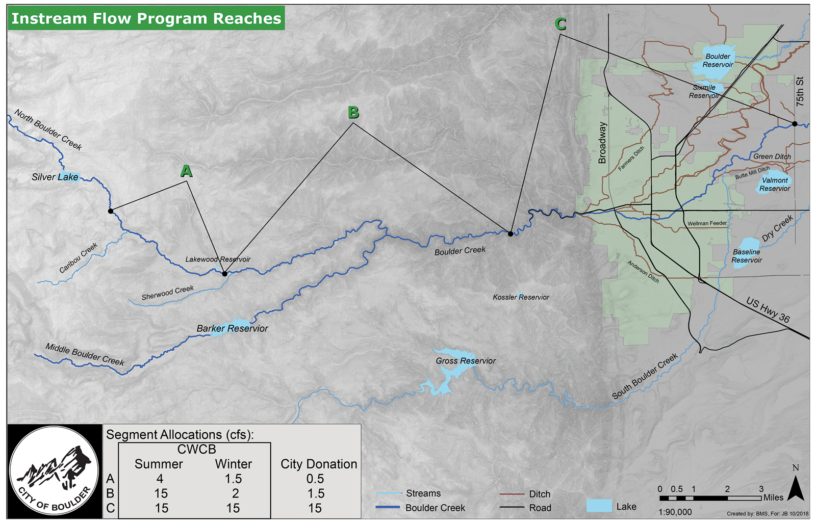
Figure 1. Map depicting locations of instream flow protected reaches along Boulder Creek. Image created by the City of Boulder (Oct. 2018).
The Boulder Creek instream flow project protects three segments from below the Silver Lake Reservoir near the headwaters of North Boulder Creek down to 75th Street in Boulder County (see fig. 1). The donated rights include reservoir releases, bypassed diversions, and changed irrigation ditch shares to support instream flows throughout the year. As part of its donation to the CWCB, Boulder retained the right to use water available under the donated rights (1) for municipal purposes under certain conditions, including drought and emergency conditions in its municipal water supply operations; (2) for municipal purposes anytime they are not needed to meet instream flow amounts; and (3) for beneficial reuse downstream of the protected reaches.26This provides operational flexibility for the city’s municipal water supply while also supporting instream flow uses by the CWCB in most years. Its participation in the Boulder Creek instream flow program has also helped the city address US Forest Service regulatory requirements for bypasses related to its diversions from North Boulder Creek as part of federal permitting for one of its raw water pipelines.27
The City of Boulder has a long-standing environmental ethos that incorporates instream flows into its water supply planning and operations. Boulder’s water supply planning documents from the 1980s identified the goal of supporting instream flows in Boulder Creek to enhance aquatic and riparian ecosystems, reflecting city planners’ prediction that dry-up periods in the creek would become more severe and frequent with increased water demands.28 Subsequent Boulder water supply and land use planning documents have included similar goals focused on balancing instream flows and environmental preservation with municipal water demands and operations, and emphasizing the connection between stream health and reliable drinking water supplies.29
Because the protected stream segments run through the Boulder city limits, and extend both above and below the city, the project benefits water quality, riparian health, and resiliency in the Boulder municipal watershed and water system operations and provides additional environmental benefits to the larger Boulder County community.
Gross Reservoir Environmental Pool Project
The cities of Boulder and Lafayette entered into an intergovernmental agreement in 2010 with Denver Water to establish a 5,000 acre-foot environmental pool in an enlarged Gross Reservoir to augment stream flows in South Boulder Creek.30 Boulder recognized the need to address low flows on South Boulder Creek as a key goal in its planning documents and identified Denver Water’s planned expansion of Gross Reservoir as an opportunity to use upstream storage to establish a robust instream flow program. Lafayette similarly identified Gross Reservoir for potential water storage in its water rights decrees, providing both a water supply and environmental benefit to its operations. The parties proactively agreed to cooperate to mitigate the reservoir expansion’s impacts to aquatic resources in the South Boulder Creek basin by creating and operating the environmental pool.31
Coordinated with municipal water system operations, releases from the environmental pool will allow Boulder and Lafayette to store their decreed water rights for later release to meet specific target flows below Gross Reservoir in South Boulder Creek throughout the year. The segments identified for the target flows include Gross Reservoir to South Boulder Road (Upper Segment, depicted as segments 1 and 2 in fig. 2) and South Boulder Road to the confluence with Boulder Creek (Lower Segment, depicted as segment 3 in fig. 2).32 The agreement also includes provisions to address emergencies such as extended drought or an unexpected problem with water storage, conveyance, or treatment infrastructure to allow for flexibility in operations to meet both target flows and municipal needs.
Boulder’s releases from the environmental pool are protected as instream flows according to a Water Delivery Agreement with the CWCB dated September 9, 2019, and a water court decree entered for Boulder, Lafayette, and the CWCB.33 Water released by Boulder to meet the target flows will be protected for instream flow uses to the extent that such flows do not exceed the amounts that CWCB has determined to be appropriate to preserve the natural environment to a reasonable degree in South Boulder Creek. Boulder’s target flow releases will support CWCB’s existing appropriated instream flow rights up to the specified amounts (see fig. 2). Boulder may then redivert the water downstream of the protected reaches for its municipal uses.
The environmental pool will provide permanent, dedicated storage for water rights owned by Boulder and Lafayette to be released to enhance stream flows in South Boulder Creek prior to downstream uses for municipal purposes by the parties. These operations provide added flexibility, resiliency, and redundancy to the cities’ respective water supply systems. In turn, the enhanced stream flows will benefit 17.3 miles of South Boulder Creek, including Eldorado Canyon State Park, South Boulder Creek Natural Area, and City of Boulder open space lands, and will support native fish populations and riparian and wetland habitats.
Figure 2. Map depicting target flows and reaches for enhanced stream flows on South Boulder Creek. Image created by the City of Boulder (Aug. 7, 2018).
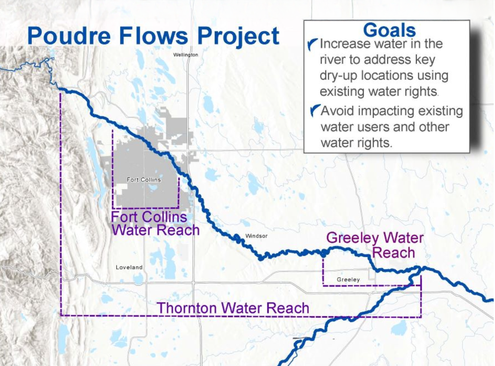
Poudre Flows Project
The Poudre Flows Project is the first stream flow augmentation plan developed pursuant to CRS § 37-92-102(4.5).34 It is a partnership amongst the CWCB; municipalities of Fort Collins, Thornton, and Greeley; Colorado Water Trust; Northern Colorado Water Conservancy District; Cache la Poudre Water Users Association; and Colorado Parks and Wildlife. The project will augment stream flows through a 52-mile reach of the Cache la Poudre River, with an overarching goal to improve river health (see fig. 3).35 The concept was first envisioned as part of the Poudre Runs Through It working group, a collaborative group of diverse partners and stakeholders in the Poudre River.36 The City of Fort Collins planning priorities incorporate similar goals, including to “[p]rotect community water systems in an integrated way to ensure resilient water resources and healthy watersheds.”37
The project anticipates that the CWCB, through agreements with water right owners, including Fort Collins and Greeley, will use previously changed and quantified water rights owned by these municipalities and potentially others to augment stream flows in six segments of the Poudre River spanning from Canyon Gage to the confluence with the South Platte River.38 Besides the instream flow protection of the environment to a reasonable degree, project partners have identified numerous additional benefits such as connectivity for fish passage and decreased temperatures and nutrient concentrations, all while avoiding impacts to existing water rights and operations.39
By integrating water supply planning with a holistic approach to water development and management that provides multiple public benefits, municipalities can become strong partners with the CWCB. Together, they can help protect instream flows and balance growing water demands and future uncertainties with the environmental values that make Colorado a beautiful place to live.
1. See generallyCoffin v. Left Hand Ditch Co., 6 Colo. 443, 447 (Colo. 1882).
2. Colo. Const. Art. XVI, §§ 5–6. See also Colo. River Water Conservation Dist. v. CWCB, 594 P.2d 570, 573 (Colo. 1979) (“The reason and thrust for this provision was to negate any thought that Colorado would follow the riparian doctrine in the acquisition and use of water.”).
9. SB 97, 49th Gen. Assemb., Reg. Sess. (Colo. 1973). See CRS § 37-92-102(3).
10. Bassi, supra note 6 at 398. See also Colo. River Water Conservation Dist., 594 P.2d at 576. SB 97 was carefully drafted to provide environmental protection through the CWCB, as a fiduciary to the public, without inviting riparian rights for adjacent landowners. Id. The Colorado Supreme Court reiterated this important distinction in St. Jude Co. v. Roaring Fork Club, LLC, 351 P. 3d 442 (Colo. 2015), ruling that a diversion from a steam for private instream flows is a “forbidden right” contrary to the prior appropriation doctrine; only the CWCB, with strict limitations identified by the general assembly, can hold an instream flow right for the benefit of the public. Id. at 451.
11. CRS § 37-92-102(3) (The CWCB is “vested with exclusive authority, on behalf of the people of the state of Colorado, to appropriate . . . such waters of natural streams . . . as the board determines may be required for minimum streamflows . . . to preserve the natural environment to a reasonable degree.” The board also may acquire water rights “in such amount as the board determines is appropriate for streamflows . . . to preserve or improve the natural environment to a reasonable degree.”). Legislation enacted in 2002 expanded the Colorado instream flow program to provide that water rights may also be used by the CWCB to improve the natural environment (and not just for preservation purposes). Bassi, supra note 6 at 391.
14. Id. at 406. The Colorado Water Trust was formed in 2001 to support Colorado’s instream flow program by promoting voluntary, market-based efforts to restore stream flows in Colorado’s rivers. The Water Trust has been instrumental in facilitating and streamlining the acquisition of water rights from willing partners for use by the CWCB. Seehttps://coloradowatertrust.org.
16. See generally CRS §§ 37-83-105, 37-92-102(8), 37-92-102(4.5).
17. The Colorado Water Plan was adopted by the CWCB in 2023 as a framework for decision-making to address water challenges and build resiliency in the state. The 2023 Water Plan is an update to the first iteration of the plan released in 2015. Seehttps://cwcb.colorado.gov/colorado-water-plan.
18. SeeSt. Jude Co., 351 P. 3d at 449 (in its use of water for instream flows, the CWCB has a “‘statutory fiduciary duty’ to the people . . . to both protect the environment and appropriate only the minimum amount of water necessary to do so . . . .”).
20. See id. at 217–19, 231, 233 (“All areas of the Water Plan are interconnected, and projects need to consider multi-purpose, multi-benefit solutions.”).
21. See id. at 217 (“Multi-purpose projects better address water supply challenges across municipal, agricultural, environmental, and recreation sectors as they occur.”).
22. See id. at 181, 204–07 (stream health and related environmental benefits can enhance municipal supply or improve the quality of life in urban areas).
23. See Decree, In re Application for Water Rts. of the Colo. Water Conservation Bd. on Behalf of the State of Colo. and Water Rts. of the City of Boulder, No. 90CW193 (Colo. Water Div. 1, Dec. 20, 1993).
30. See Decree, In re Application for Water Rts. of City of Lafayette, City of Boulder, and Colo. Water Conservation Bd. in Boulder Cnty., No. 17CW3212 (Colo. Water Div. 1, Feb. 11, 2021). The author represented the City of Boulder in Case No. 17CW3212 and was involved in prosecuting the case and negotiating the underlying agreement with CWCB.
31. Denver Water’s enlargement of Gross Reservoir is the subject of pending litigation.
32. The target flows and target reaches are based on previously collected data and analysis by Colorado Parks and Wildlife using the R2Cross method, which supported CWCB’s previous instream flow appropriations.
38. See Application, In reApplication for Water Rts. of Cache La Poudre Water Users Ass’n, City of Fort Collins, City of Greeley, Colo. Water Tr., N. Colo. Water Conservancy Dist., City of Thornton and Colo. Water Conservation Bd. in Larimer and Weld Cntys., No. 21CW3056 (Colo. Water Div. 1 Apr. 29, 2021).
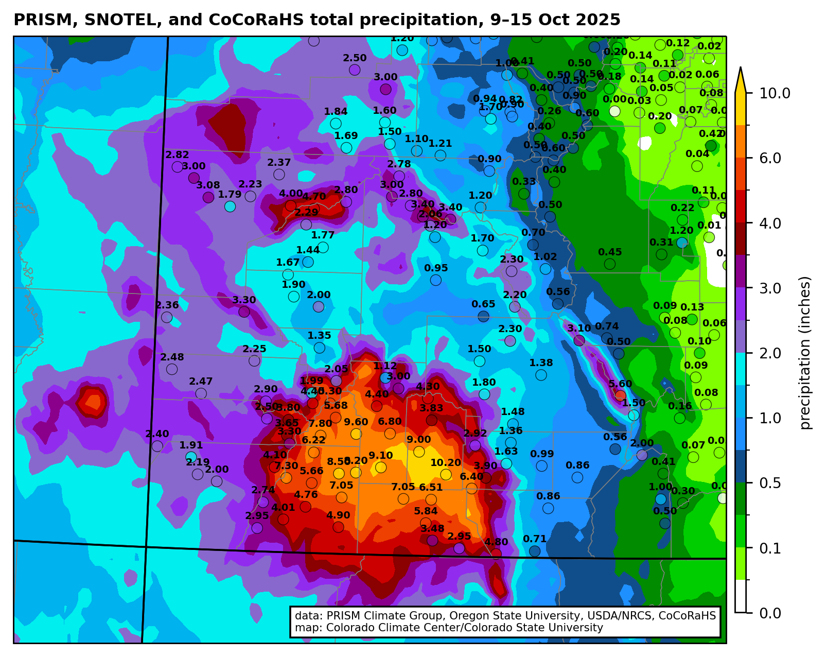
Total precipitation (inches) from 9-15 October 2025 with gridded data from the PRISM Climate Group and observations from the Community Collaborative Rain, Hail, and Snow (CoCoRaHS) network.
On January 6, 2026 Town of Pagosa Springs staff informed the Pagosa Springs Town Council about the town’s ongoing flood recovery funding efforts in the wake of the Federal Emergency Management Agency’s (FEMA’s) denial of the town’s request for $5.7 million to aid cleanup efforts. Development Director James Dickhoff and Projects Manager Kyle Rickert were both on hand to walk the council through various other funding opportunities, with Dickhoff stating, “We are not counting on FEMA money to come through to us” after the denial on Dec. 21, 2025. Dickhoff stated that staff just wanted to inform the council “on where we are at” regarding the town’s relief funding efforts from the October 2025 flooding…
The total project cost of river cleanup and restoration following the October flood event is estimated to be just shy of $6 million, stated Town Manager David Harris in correspondence. Rickert explained that, with the FEMA funding off the table, the town is pursuing several state grants, and possibly a state loan, as well as two other federal funding programs. Dickhoff added that if the town wanted to pursue “the loan opportunity through the Colorado Water Conservation Board (CWCB),” the council would need to put it before the voters in an upcoming spring election to be legally eligible to take out the loan…
Rickert explained that the federal Emergency Watershed Protection had awarded the town about $3.3 million and the Colorado Office of Emergency Management awarded $463,504 in funds. These funds will go toward embankment stabilizations near the Pagosa Springs History Museum and near 6th Street, pedestrian bridge abutment stabilization at Centennial Park, restoring the River Center ponds, as well as Apache Street bridge repairs and log jam removals, all coming with a total project price tag of $4,178,038, the slideshow states…
He added, “The river is an important part of our tourism portfolio and we need to get it cleaned up” and make it safe for those recreating in the river before summer hits. Rickert then informed the council about a Colorado Parks and Wildlife (CPW) Fishing is Fun grant that the town has requested in the amount of $328,603. This grant would go toward dredging the River Center ponds, a headgate replacement at Pond #1 (the east pond), ditch restoration, debris and sediment removal upstream of town limits to the future 1st Street pedestrian bridge, as well as rebuilding rock structures in the same area. Rickert noted that the town was also awarded $15,000 from History Colorado Emergency Grant for its ongoing efforts to stabilize the river bank near the museum…One or possibly two water gauge stations would give the town an estimated two hours of warning time as water levels rise during another flood event, providing historic data as part of the U.S. Geological Survey monitoring system, she noted. This grant application would be due by Jan. 31, so she asked the council to pass a resolution supporting the CWCB river gauge grant, which the council passed unanimously.
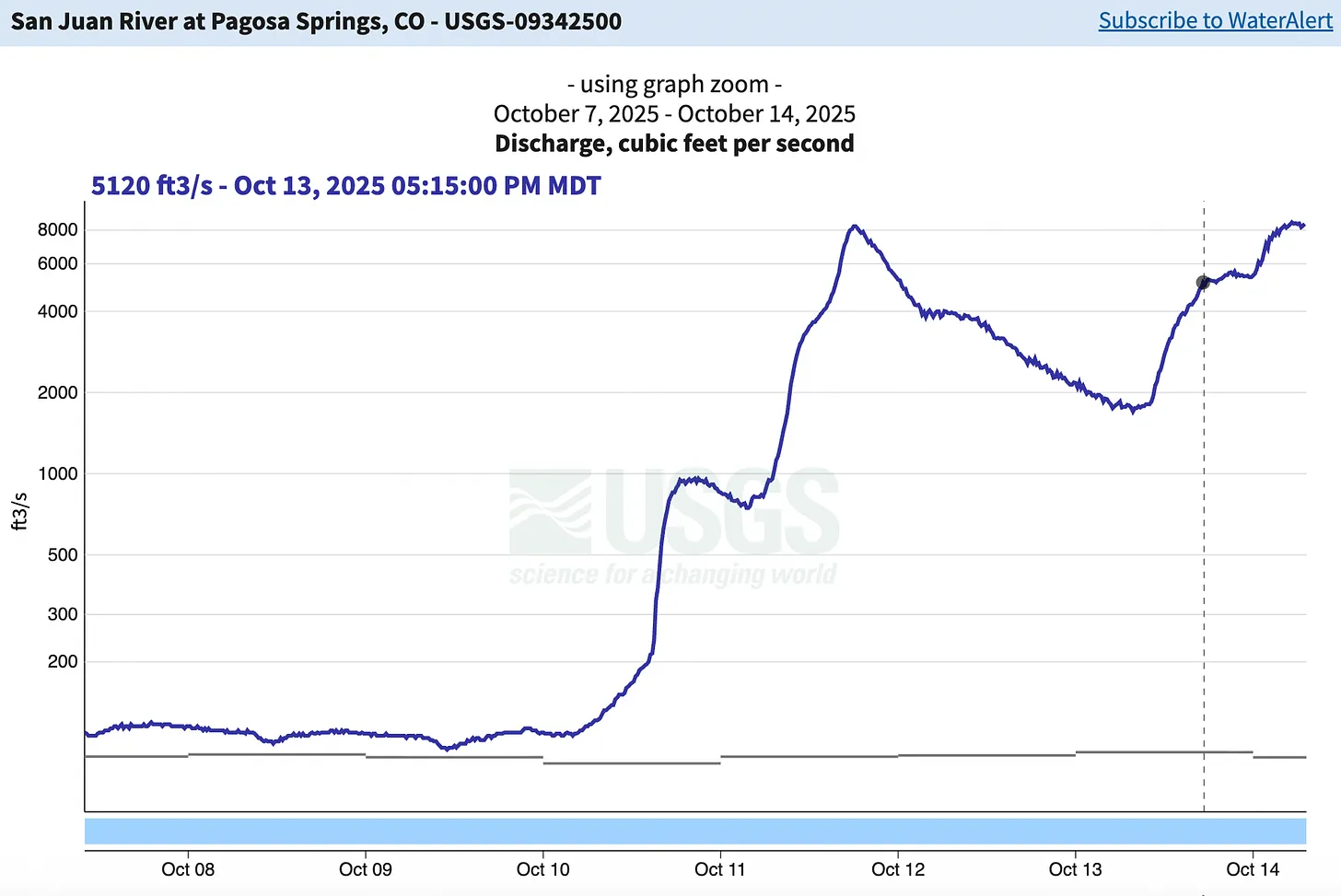
The San Juan River has peaked above 8,000 cfs twice in the last several days, reaching the highest levels seen since the 1927 flood. Source: USGS.
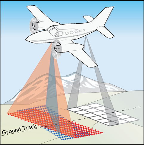
Aerial view of the snowpack in the San Juan Mountains of southwest Colorado on Dec. 3, 2021. Scientists and water managers use a variety of methods to monitor the snowpack, which supplies most of the water flowing in many Western streams and rivers. Photo by Mitch Tobin/The Water Desk.
A controversial recent study highlights an old truth about the American West’s snowpack: it’s difficult to measure—and just as hard to forecast how much of its water will ultimately reach tens of millions of people and vast swaths of farmland.
Water managers have increasingly turned to aircraft that use lasers to gauge the snowpack across entire basins. But the Aug. 15 scientific paper argues for a less expensive strategy: focusing new monitoring efforts on a select number of locations known as “hotspots” that excel at predicting how much water will run off from the snowpack—a frozen reservoir that can change dramatically over short distances.
Snowfall rates vary widely with elevation, and the amount of water locked in falling snowflakes shifts from storm to storm.
On the ground, snow accumulation depends on the wind, the forest canopy overhead, the exposure to the sun and the amount of dust that lands on the snowpack. Even a homeowner armed with a ruler can find very different snow depths depending on where they poke in their backyard.
For water providers, knowing how much water is stored in the snowpack is essential. In much of the West, snowmelt supplies most of the runoff that flows through streams, rivers, reservoirs, irrigation canals and household faucets.
If water managers overestimate the snowpack, their customers can be left high and dry later in the year. But if analysts underestimate streamflows, reservoirs can fill faster than expected—raising the risk of disastrous flooding.
With climate change making the snowpack less reliable and redefining what “normal” means, the pressure on forecasters is intensifying in a rapidly growing region with a well-documented gap between water supply and demand. Even a perfect knowledge of the snowpack’s water content doesn’t guarantee accurate streamflow projections because factors such as soil moisture, groundwater levels and late-season weather cloud the picture.
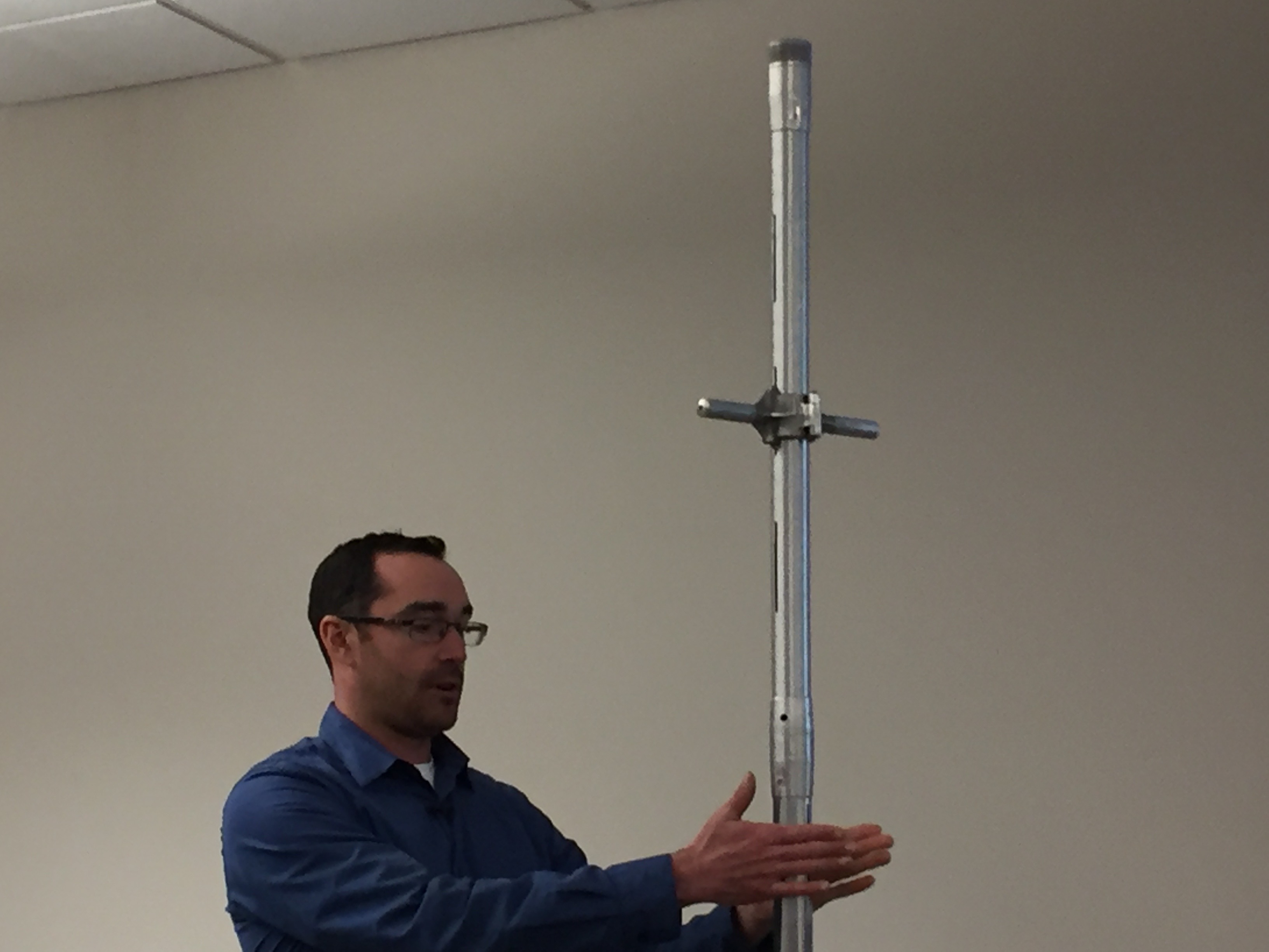
Karl Wetlaufer (NRCS), explaining the use of a Federal Snow Sampler, SnowEx, February 17, 2017.
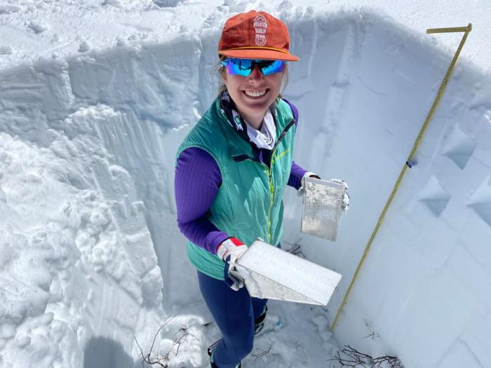
Scientists and water managers, aware of the high stakes, began formally measuring the snowpack to make water forecasts more than a century ago. They selected key locations in the high country, plunged hollow metal tubes into the snow and weighed the extracted cores to calculate the water content—a technique still used extensively today.
During the late 20th century, officials installed hundreds of automated stations across the West’s watersheds as part of the SNOTEL network. These sites use “snow pillows” to measure the weight of the overlying snow and estimate its water content. Forecasters then correlate these long-term snow records with historical streamflows to predict a basin’s water supply.
In the 21st century, airborne snow surveys have expanded rapidly. Aircraft equipped with lidar—a laser-based technology—precisely map the snow depth across entire watersheds while an onboard spectrometer scans the snowpack’s reflectivity. Snow depth is determined by subtracting lidar readings taken when snow is absent from those taken when snow is present. Scientists combine those measurements with estimates and observations of snow density to calculate the water content, known as the snow water equivalent.
Satellites also provide valuable data on the snowpack, especially its extent on the ground, but reliably measuring snow water equivalent from space remains elusive. Clouds and forests can also obscure or complicate a satellite’s view.
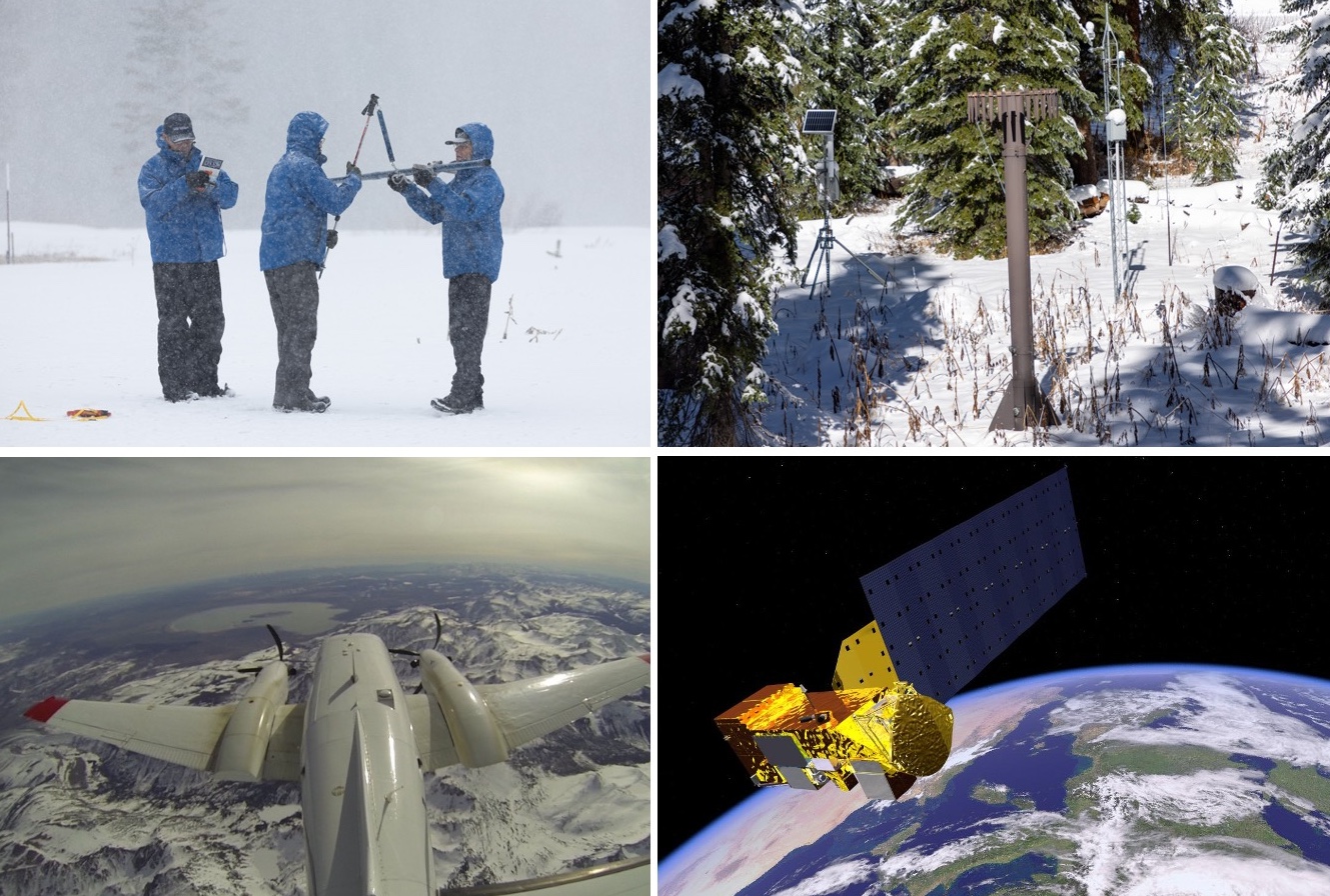
Four ways scientists monitor the snowpack. Clockwise from upper left: a manual snow-course survey (California Department of Water Resources); an automated SNOTEL station (Mitch Tobin/The Water Desk); an illustration of a satellite carrying the MODIS instrument (NASA); and airborne mapping (NASA).
While technologies that estimate an entire watershed’s snowpack are on the rise, the recent hotspots study argues that water forecasters could gain crucial insights by targeting future monitoring at a limited set of locations.
The authors say these 62-acre hotspots not only are strong predictors of how much water will run off in the spring and summer, but also could be more cost-effective than mapping the snowpack across a whole watershed using aircraft. That approach has become more common due to the work of Airborne Snow Observatories, Inc. (ASO), a company that spun out of research at NASA’s Jet Propulsion Laboratory.
“The greatest gains in water supply prediction come from leveraging existing stations and expanding snow measurements to the right places, rather than everywhere,” the authors write in Communications Earth & Environment.
But in the tight-knit world of Western snow science, the paper has sparked pushback from supporters of airborne snow monitoring.
Jeff Deems, a co-founder of ASO, said the paper is a “statistical curiosity” and criticized both its methodology and the conclusions it draws about snowpack monitoring.
“Our datasets have become the gold standard, the benchmark against which others are evaluated,” Deems said.
The Colorado Airborne Snow Measurement (CASM) program produced a strongly worded critique of the study, which used a proxy for the ASO data, rather than actual measurements from aircraft.
“Although this paper is published in a well-known journal, it makes unsupported, misleading and editorialized claims about the cost, value, and performance of airborne lidar for streamflow forecasting,” said the rebuttal from CASM, a group of stakeholders whose planning team includes ASO, water providers, the Colorado Water Conservation Board (CWCB) and other organizations. “The authors make a series of critical logic and analysis errors which when combined with their over-broad conclusions result in a very misleading paper.”
But study co-author Cam Wobus wrote in an email that the paper “might have struck a nerve” because “it showed that wall to wall measurement of snow may not be needed to create more accurate water supply forecasts, which ASO could have perceived as a threat to their business model.”
Despite the sharp differences among snow researchers, experts agree there’s no silver bullet for monitoring the snowpack or predicting streamflows. As warming temperatures and evolving storm patterns continue to transform the snowpack, both old-school methods and newer technologies will be needed to better manage the region’s scarce water resources.
“Snowpack estimation and streamflow forecasting is a vast and unsolved field of research,” the CWCB wrote in response to questions from The Water Desk.
Although CWCB’s logo was included at the bottom of CASM’s rebuttal, the agency said in an email that the document “should not be misconstrued as an official position statement” and that “CWCB has acted as a funding and coordination partner” to CASM.
An airborne survey created this map of snow depth for Colorado’s Maroon Bells on April 9, 2024. Source: ASO.
Searching for snowpack hotspots
The hotspots study set out to test an intuitive idea: in high-elevation watersheds, the snowpack in certain locations can be especially useful for predicting streamflow.
“There are places within drainage basins that, if you train your water-supply forecast on the snow record in those locations, you’ll have a better forecast than if you use the basin average,” said co-author Eric Small, a professor of geological sciences at the University of Colorado Boulder.
“If you think about a drainage basin, there’s going to be places in that drainage basin where there’s not a lot of snow, or there’s not much connection between the snowmelt and the runoff,” Small said. “There’s going to be other places in the basin where there is a lot of snow and a lot of connectivity between the snowmelt and the runoff. So it should not be a surprise that there’s locations within a basin that are more predictive of this seasonal water supply.”
In general, locations with the deepest, most persistent snow are more likely to be hotspots.
“Anyone who’s seen a basin in Colorado and sees the south-facing slopes that are bare of snow and the north-facing slopes that have snow three feet deep in the springtime recognizes that once you take an average across all of that, the stuff on the south-facing slopes isn’t going to matter at all,” said Wobus, a principal at CK Blueshift, LLC, a consulting firm that works on water and climate issues.
“It’s silly to fly an entire basin if 30% of that basin doesn’t have any snow on it, so that’s an easy fix right there,” Wobus said.
While hotspots typically accumulate lots of snow, what’s happening beneath the snowpack is just as important. “The hotspots are locations where there’s both a lot of water, and when it melts, a large fraction of that water would get into the stream,” Small said.
Hotspots tend to have shallow or relatively stable groundwater storage and soil moisture levels that don’t vary year to year.
“The hotspots are places where there’s either enough snow or minimal enough variations in storage that the water is getting to the stream and the water is getting to the stream at the right timescale,” Small said.
Each basin may have numerous hotspots. “The hotspots weren’t unicorns,” Small said. “There were many possible hotspots. We had an objective measure to choose the official hotspot in the paper, but you could have chosen many other locations that were also predictive.”
Once a hotspot is identified, the authors outline several potential ways to tap its predictive power. One option is to add a new SNOTEL station at the site, although that may not be feasible because of the terrain or land protections. Another possibility is to use remote sensing from a plane or a drone. The authors write that one or two flight paths that observe the hotspot could gather data “at a substantially lower cost than more conventional wall-to-wall basin coverage.”
Even recreationists could help gather data from snowpack hotspots. “You could use citizen science to do it. You could send a bunch of backcountry skiers out to your location for fun, give them an app,” Small said. “They’re probably already going there. If you saw where people were skiing, they would probably have mapped out the hotspots already.”
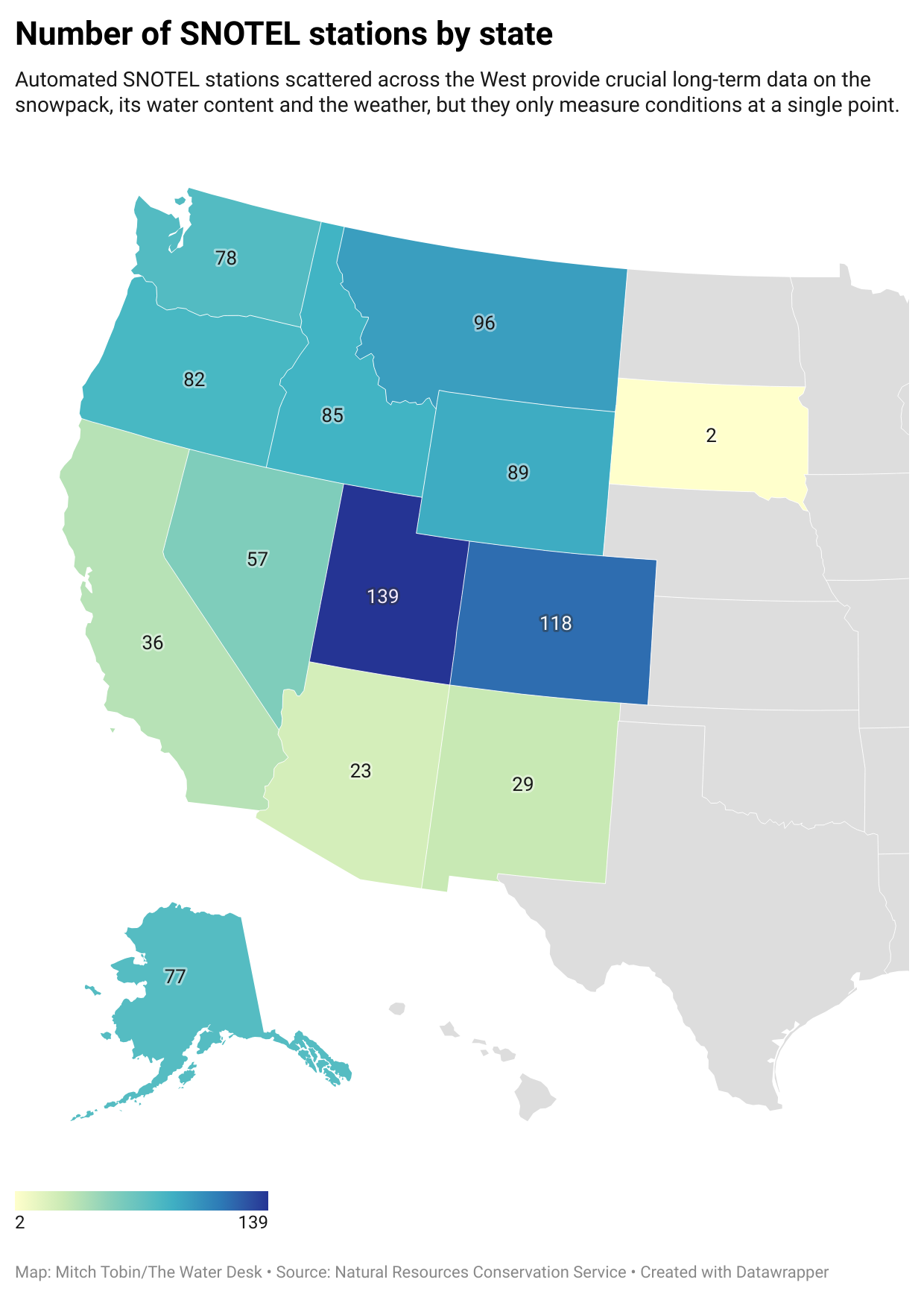
Map: Mitch Tobin/The Water Desk • Source: Natural Resources Conservation Service • Created with Datawrapper
A shortcut, or a statistical trap?
Critics of the hotspots paper agree that some parts of a watershed can carry more predictive weight for streamflows than others.
“It’s not a new concept, and it’s a very seductive one. It’s essentially the premise behind the SNOTEL network,” Deems said.
But to some scientists who dispute the study, hotspots can hide as much as they reveal—and potentially mislead water managers as the West’s climate evolves and as the hydrology of high-country landscapes is reshaped by disturbances, such as the increasing frequency of wildfires.
“Even if they did everything right—found these hotspots—the likelihood of them retaining the same statistical predictive power going forward is essentially nil,” Deems said.
The rebuttals to the paper have challenged both its analysis and the real-world implications the authors infer from their results.
Noah Molotch, a professor of geography at the University of Colorado Boulder and director of the Mountain Hydrology Group at the Institute of Arctic and Alpine Research, said “the study doesn’t accurately portray the direction that water managers have been moving for a couple of decades now.”
“My concern there is that it takes us further down the path of being blind to the spatial patterns that govern water supply and that can lead to surprises for water managers,” Molotch said.
Although the hotspots study has implications for airborne snowpack monitoring, the paper didn’t analyze data gathered by aircraft, which has been collected only in select watersheds and over a shorter time period than the authors examined.
Instead, one of the ways the researchers probed the snowpack in 390 basins in the West was to combine satellite data from 2001 to 2023 with historical weather data. The satellite images, collected by the MODIS instruments aboard two NASA spacecraft, show the fraction of each pixel covered by snow and the reflectivity of the snowpack, among other metrics. Each pixel is a square with 500-meter (1,640-foot) edges.
The authors argue that this type of data serves as a reasonable “proxy” for the basin-wide estimates that could be obtained from prospective satellite missions and current airborne monitoring. Small said five different datasets were examined, and all showed similar results.
But the CASM critique argues that the proxy dataset has “a demonstrated average error of 35% (ranging from 20-60%)” when compared to airborne lidar, and its much coarser resolution further limits its utility.
The paper’s authors “make the assertion that that dataset has been shown to be accurate and, in their language, therefore serves as a reliable proxy for airborne lidar,” Deems said. “That assertion is incorrect, and that undercuts the entire rest of the paper, sadly.”
Deems said the study used the date of snow disappearance to back-calculate how much snow was there while also “blending in an atmospheric model precipitation product, which is highly uncertain.”
By contrast, Deems said, ASO creates “a highly accurate map of snow depth throughout the watershed,” which is then paired with estimates of snow density informed by SNOTEL measurements and hand-dug snow pits. What emerges, he said, is a basin-scale estimate of snow water equivalent that’s within about 1% of the actual volume.
“That’s better than we can measure streamflow,” Deems said.
A video from Colorado’s Northern Water explains how the utility uses ASO data.
Clashes over the merits of datasets are grist for the academic mill, but critics raise a broader concern: the paper takes a retrospective look at snowpack-streamflow relationships in an age of extreme weather and shifting baselines.
Scientists have an awkward name for this pivotal issue: “stationarity.” In simple terms, it’s the assumption that the past is a reliable guide to the future. But just as mutual-fund disclaimers warn that past performance is no guarantee of future returns, climate change is making historical patterns less trustworthy.
Storm tracks are migrating. Warmer temperatures mean more winter rain and less snow. Rising evaporation rates are drying out soils. And both the timing and volume of runoff are in flux as the weather changes and high-elevation wildfires remake watersheds.
The hotspots strategy, according to the CASM rebuttal, “does not test whether those sites remain predictive under shifting climate conditions or extreme events” and “what looks like a hotspot in the historical record may fail under current or future conditions.”
What to do with hotspots?
On a practical level, the hotspots paper argues that snow researchers and water managers could mine these locations for essential data by installing additional SNOTEL stations or using remote sensing. But critics say several big hurdles stand in the way of implementation, many of which are acknowledged in the study.
First, a hotspot with 500-meter edges covers nearly 2.7 million square feet, but the snowpack may vary greatly within that footprint. Where in that area should a new SNOTEL monitoring station go? Cost is another concern. “Installing and maintaining a station is not cheap either—$100,000 easily between gear and personnel time and maintenance,” Deems said.
Second, terrain and land-use rules can make installation impractical or illegal. “In many cases, it’s going to be impossible to put a station there, either because it’s sloped and the snow pillows don’t work on slopes, or because it’s in the wilderness or in avalanche terrain or something like that,” Deems said. Drone flights—another potential monitoring tool—are also prohibited in federal wilderness and face their own logistical challenges.
Third, any new station only generates data going forward. It doesn’t provide the long historical record that water managers need to train their models and make streamflow predictions. “It’s not going to be useful until you probably get about 30 years of data,” Molotch said, “and then let’s think about how much the climate may have changed over those three decades.”
The components in a typical SNOTEL station. Source: Natural Resources Conservation Service.
At its core, the dispute over hotspots reflects a long-standing divide in hydrology. One camp relies on statistically based approaches, such as using a select number of “index” sites to measure the snowpack and predict streamflow based on historical records. Another paradigm favors physically based methods that employ the laws of physics to account for the coming and going of water molecules in a basin, such as using aircraft to map the snowpack.
“Historically, we’ve increasingly been moving toward physically based approaches in hydrology,” Molotch said. “At some point, we may have a complete passing of the baton toward physically based approaches. I don’t know if and when that will be in our future, but I think that that is the way that things are migrating over time.”
Small said that ASO data “will give you the total number of water molecules in a basin” if you accept their snow density model, but that’s only part of the story. To predict streamflow, forecasters must account for other factors, including how much water is lost to the atmosphere when it evaporates, transpires from plants or converts directly from ice to water vapor, a process known as sublimation. Soil moisture and groundwater levels also shape the hydrologic cycle.
“The total volume of water in the snowpack is not hugely predictive of streamflow compared to what you get from the hotspots, and that has to be the case,” Small said. “If you have any variations in the basin from evapotranspiration or soil moisture storage or groundwater storage—that has to be the outcome. And I think we probably should have said that in the first sentence of the paper.”
Using an “all of the above” approach
Denver Water describes the snowpack in the mountains west of the city as the utility’s biggest reservoir. To supply its 1.5 million customers, Denver Water uses a variety of techniques to track the snowpack, including manual measurements, automated SNOTEL stations, ASO flights above key watersheds and satellite data that is blended into reports that Molotch and colleagues generate at the University of Colorado Boulder.
“We take an all of the above approach,” said Taylor Winchell, climate change adaptation program lead at Denver Water. “We think that all of these systems really have their place and are all important in giving us the full picture of the snowpack that we’re hoping to gather to help us make confident decisions.”
Each type of snow monitoring has its benefits and limitations. “They each fill a gap that the other doesn’t,” Winchell said.
The SNOTEL system, for example, can provide hourly or daily readings of the snowpack and offers long historical records, but it only measures conditions at a single point. The stations also tend to sit in mid-elevation clearings that are easy to access, so they don’t necessarily reflect the diversity of the West’s terrain and overlying snowpack.
“We often don’t have measurements at those higher elevations, and it kind of leaves a blind spot in our understanding of the snowpack,” Winchell said.
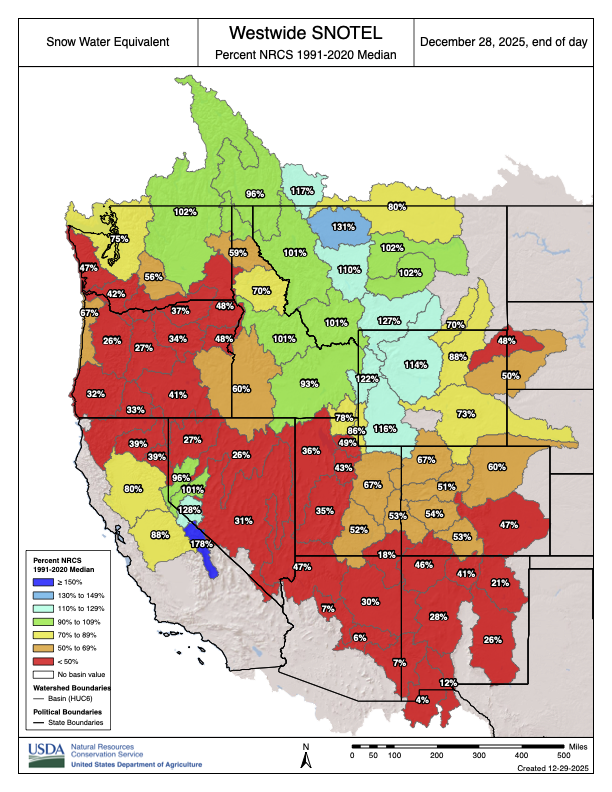
Westwide SNOTEL basin-filled map December 28, 2025.
Like many water providers in the West, Denver Water has been grappling with a growing mismatch between snowpack levels and the amount of water that eventually reaches streams and rivers in the spring and summer.
“We just don’t quite expect the same amount of streamflow production nowadays as we would’ve historically with similar levels of snowpack,” Winchell said, noting the influence of soil moisture levels, evaporation and sublimation. “We can’t go off the same assumptions that we might’ve had in the past, and so every year it creates this kind of new and intensified challenge to understand how the snowpack is going to translate into streamflow.”
Denver Water has used ASO data since 2019 and spent an average of about $200,000 per year on the airborne surveys. That first year, ASO surveyed the watershed around Dillon Reservoir—a linchpin in the utility’s supply that collects runoff west of the Continental Divide so that it can be pumped through a 23-mile tunnel bored beneath the Rocky Mountains and reach the east side of the Divide, where most of Colorado’s population lives.
“With those flights, we saw kind of immediately the high value of this information for our decision-making processes,” Winchell said. ASO found the snowpack was bigger than what Denver Water expected, Winchell said, so the utility “immediately increased outflows from Dillon Reservoir so that we’d be able to capture that snowpack without flooding downstream of the reservoir.”
ASO’s high-resolution data is valuable for Denver Water because it “fills in the gaps between those station measurements,” Winchell said.
In the large watersheds that supply the utility, “you can have storms and snow patterns that are quite different from one side of the watershed to the other, and you might have different diversion systems in each part of that watershed,” Winchell said. “You might have had a forest fire in one part of the watershed that impacts the snowmelt within that sub-watershed. So really being able to have that detailed picture of the full watershed, we do find value in that.”
But the cost of airborne surveys remains a critical issue.
“It’s still been a struggle year over year to get the funding needed even to fly what we see as the baseline number of useful flights,” Winchell said. “There’s still a lot of room for both adding additional flights in watersheds that are already being flown, as well as conducting ASO flights in watersheds throughout the state that don’t currently have ASO flights.”
Costs versus benefits
In Colorado, CASM was formed in part to secure additional funding to expand ASO flights above the state. CASM’s annual budget in 2025 was $4.5 million, with state funding accounting for 52% and the rest from federal, local and other sources.
The U.S. House of Representatives recently passed bipartisan legislation that would reauthorize and update the federal Snow Water Supply Forecasting Program “to incorporate modern technologies, including LiDAR and satellite imagery, to improve the accuracy of snowpack and water-supply predictions,” according to sponsor Jeff Hurd, R-Colo.
Backers of airborne surveys acknowledge that flights aren’t cheap—two flights over a basin can cost a couple of hundred thousand dollars per year—but they say the data can generate far greater benefits. A more precise read on the snowpack can prevent flooding and allow water managers to devote excess supplies to groundwater recharge. Conversely, advance warning of shortages can help avoid disruptions for both agricultural and urban water users.
“The value of these data can be off the charts,” Deems said, with some case studies from California showing a return on investment between 50 and 200 to one.
In the headwaters of Northern California’s Feather River, which supplies the California State Water Project, Deems said ASO’s data improved water management. In 2021, the year before ASO’s flights began, water managers “thought they had a decent snowpack,” Deems said, but they had to dramatically scale back allocations, eventually to zero, “because the water just didn’t show up,” causing significant impacts to farmers and other water users.
“The following year, we started flying in the Feather River,” Deems said. “Our February flight showed that they had half the water they thought they had, so it looked like essentially a repeat of the prior year, except this time they knew about it in February, rather than finding out about it when the water didn’t show up at the stream gauge in July.”
Dillon Reservoir supplies water to Denver and releases water into the Blue River which feeds into the Colorado River.
The future of snowpack monitoring
Looking ahead, the stakes are only growing for snowpack monitoring and streamflow forecasting as the climate warms and the West continues to add new water users.
Despite their varying views, snow experts agree that a diversity of approaches will be needed in the foreseeable future. The hotspots study authors see value in the ASO flights, and backers of airborne surveys would like to see more SNOTEL stations.
“We are first in line to advocate for more observations, especially if they can be in environments that are different than the current set of observations covers,” Deems said.
The question, Wobus said, is “how do we use combinations of advanced monitoring technologies like lidar and satellite observations and things like that in a framework that will help you improve water supply forecasts without having to measure everything?”
“There’s a lot of room to improve the economics of snow monitoring,” Wobus said. “If we’re talking about the difference between flying every basin once a year and getting total coverage at a cost of, let’s say $10 million a year for the state of Colorado, versus adding a few more SNOTEL stations in a few places where you really need it—there’s a lot of real estate in between those two things.”
Left to right, Jack Hannaford, Robert Miller, Chief of the Snow Survey Office for the California Department of Water Resources and helicopter pilot Harry Rodgers conduct the monthly snow survey near Loon Lake reservoir in the Eldorado National Forest in El Dorado County. A helicopter was used to access the remote location in the Sierra Nevada Mountains. Photo taken March 9, 1960. Vince R. Arrant / California Department of Water Resources
When ASO maps the snowpack in an entire basin, its aircraft flies back and forth in a pattern often likened to mowing a lawn. Small and Wobus said that one way to save money would be to do more limited flights and use machine learning—a type of artificial intelligence—to extrapolate the results.
“If you fly one strip and combine that with a machine-learning model, you can get like 98% of the way there, and you can save a whole boatload of money,” Wobus said. “You could just fly a straight line across the state of Colorado and then turn around and fly back and get almost as much information as you’re getting by flying like a lawnmower back and forth across the basin.”
But some backers of airborne mapping are skeptical.
“That would be bringing a lack of confidence back into the system, and that’s a difficult thing to ask a water manager to accept, especially after we’ve shown what’s possible,” Deems said.
Drones have also become part of snow hydrologists’ toolbox. While the hotspots paper argues that using lidar technology mounted on drones would be less costly than flying large aircraft, that approach “does not reflect the logistical and financial realities of operating such a program in Colorado’s mountain environments,” according to CWCB.
“Drone-based lidar systems require extensive permitting, frequent flights due to limited range and battery life, and highly trained operators to meet accuracy standards comparable to crewed aircraft,” CWCB wrote. “No program currently exists with the resources, planning, or data management structure to deploy drone surveys at the basin scale needed for operational water forecasting.”
For many snow hydrologists, the holy grail would be to launch a dedicated satellite that could look down from space and estimate the water content of the snowpack around the planet using, for example, microwave sensors. But that’s literally a heavy lift.
“There’s lots in the works,” Deems said. “But the global solution is pretty elusive, and folks have been trying to do this for decades.”
The technology exists today to measure snow water equivalent with a satellite, “but not everywhere and not all the time,” Molotch said. One major obstacle is that satellite monitoring may not work when the snowpack is wet, which is especially vexing in the warmer, maritime snowpacks near the West Coast.
“Snowpack conditions in the Sierra Nevada of California can be wet at any time of year between storms when the sun’s out and it starts to warm up,” Molotch said. “As the climate warms, we would expect that snow wetness will be increasingly problematic for microwave remote-sensing techniques. But I think on the positive side, if we’re able to make snow water equivalent measurements in some locations, that helps us provide information for models that can fill in the gaps.”
In July, NASA and India’s space agency launched NISAR, a new radar satellite built to track how Earth’s surface is evolving. While not dedicated to monitoring the snowpack, the mission will measure changes in snow, glaciers, sea ice, ice sheets and permafrost. Operating day or night, NISAR’s signals can penetrate clouds, and the satellite will observe nearly the entire Earth’s surface twice every 12 days.
Illustration of the new NISAR satellite. Spacecraft hold promise for measuring the West’s snowpack but face challenges of their own. Source: NASA.
The NISAR mission “introduces a promising avenue for cost-effective, large-scale snow depth and snow water equivalent” estimates, according to a January study in Frontiers in Remote Sensing. A 2024 paper in Geophysical Research Letters concluded that NISAR offers a “promising path toward global snowpack monitoring.” While errors increase in forests with a denser canopy, the 2024 study said the satellite “may be feasible for snowpack monitoring in sparse to moderate forest cover.”
What research and data would deepen understanding of the snowpack in the future?
“Where to begin?” Winchell said with a laugh.
In addition to having more manual measurements, more SNOTEL stations, more ASO flights and even a citizen-science effort, Winchell said better knowledge of snowpack temperatures would be helpful to Denver Water because that “provides a really strong indication of when the snowpack is ready to melt.” Additional soil moisture data could also improve the utility’s forecasts of how the snowpack translates into streamflows.
“The field of snowpack research is just a crucial field with really lots of exciting work ahead, especially as these new, really high-value, high-accuracy datasets are coming into play,” Winchell said. “I think decades into the future we’ll wonder how people really went about managing the snowpack water supplies without this information.”
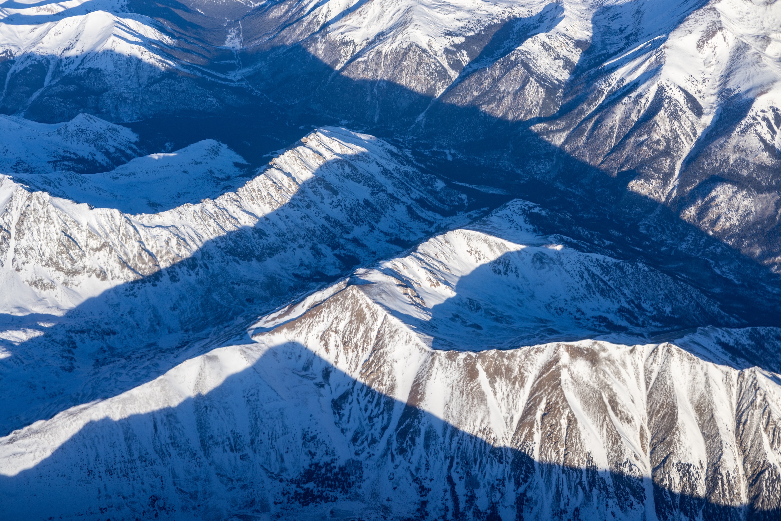
Aerial view of the Rocky Mountain snowpack over central Colorado on Dec. 3, 2024. Photo by Mitch Tobin/The Water Desk.
This story was produced and distributed by The Water Desk at the University of Colorado Boulder’s Center for Environmental Journalism.
Editor’s note: Two of the co-authors of the hotspots paper and one of the critics of the study are affiliated with the University of Colorado Boulder. The Water Desk is also based at the University of Colorado Boulder but operates as an editorially independent journalism initiativeand is solely responsible for its content.
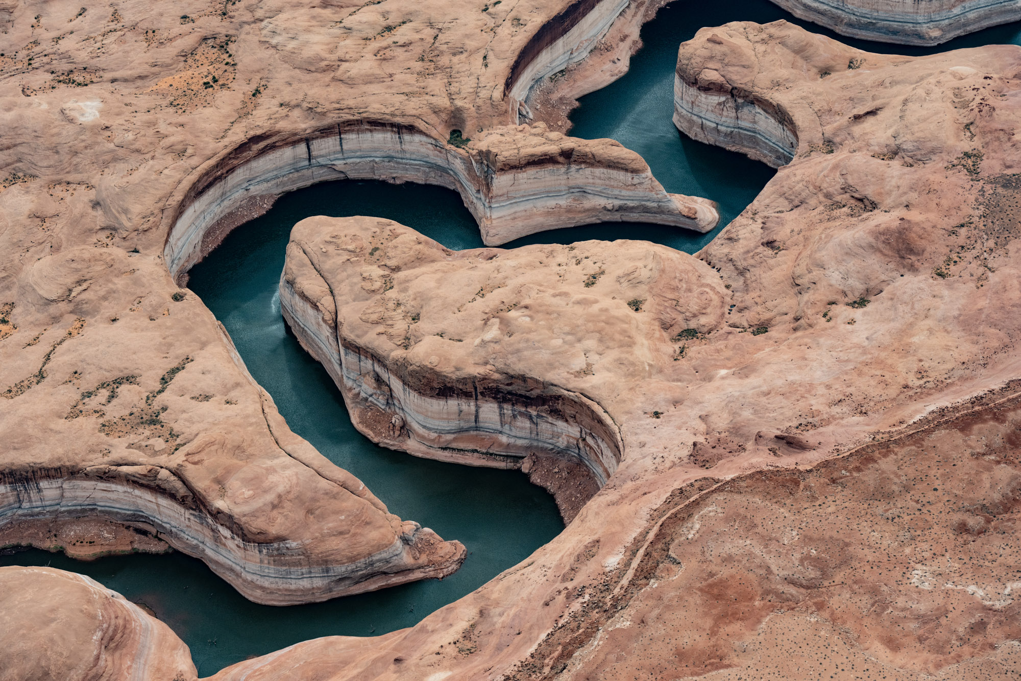
The Colorado River fills Glen Canyon, forming Lake Powell, the nation’s second-largest reservoir. The reservoir could drop to a new record low in 2026 if conditions remain dry in the Southwestern watershed. (Alexander Heilner/The Water Desk with aerial support from LightHawk)
Click the link to read the article on the Inside Climate News website (Wyatt Myskow, Blanca Begert, Jake Bolster):
December 19, 2025
At the Colorado River Water Users Association annual conference in Las Vegas, Colorado River Basin states remain at an impasse over how to cut their water use as Lake Mead and Lake Powell verge on record lows.
The Colorado River Basin is, quite literally, 50 feet away from collapse, and an agreement to save it is nowhere in sight.
Water titans clashed at Caesars Palace in Las Vegas this week, where negotiators from each of the seven Colorado River Basin states outlined what they have done to protect the river—and pointed fingers at each other, demanding more.
Udall/Overpeck 4-panel Figure Colorado River temperature/precipitation/natural flows with trend. Lake Mead and Lake Powell storage. Updated through Water Year 2025. Note the tiny points on the annual data so that you can flyspeck the individual years. Credit: Brad Udall
Talks over how to manage the river after 2026, when current drought mitigation guidelines expire, began two years ago. Federal deadlines have come and gone, and the stakes are higher than ever as climate change and overuse continue to push the river that 40 million people rely on to the edge. Still, the states are refusing to budge.
“It’s now 2025, we’re here in a different hotel a couple years later and the same problems are on the table. In the last two years, we’ve been spinning our wheels,” said JB Hamby, California’s lead negotiator, at the annual Colorado River Water Users Association conference.“Time has been wasted, and like water, that’s a very precious resource.”
The back of Glen Canyon Dam circa 1964, not long after the reservoir had begun filling up. Here the water level is above dead pool, meaning water can be released via the river outlets, but it is below minimum power pool, so water cannot yet enter the penstocks to generate electricity. Bureau of Reclamation photo. Annotations: Jonathan P. Thompson
The Colorado River flows from Wyoming to Mexico, supplying water to seven U.S. states, two Mexican states and 30 tribes. But the bedrock law guiding its management, the 1922 Colorado River Compact, overestimated how much water the river could provide, leading to state allocations that promised more than was ultimately available. The nation’s two largest reservoirs, lakes Mead and Powell, which for decades have met the excess demand driven by overly optimistic allocations, are at the brink. Lake Mead is 33 percent full; Powell is just 28 percent full. If the latter’s water levels drop by an additional 50 feet, the water behind Glen Canyon Dam would be trapped, limiting deliveries to California, Arizona and Nevada, and preventing the dam from generating hydropower.
The federal government’s data indicate that Lake Powell could drop to that level, known as “deadpool,” by the summer of 2027 if significant cuts aren’t made.
Yet, the states remain stuck on the same points that, for years, have prevented any of them from agreeing to reduce their long-term use enough to prevent the collapse of the Colorado River system.
The structural deficit refers to the consumption by Lower Basin states of more water than enters Lake Mead each year. The deficit, which includes losses from evaporation, is estimated at 1.2 million acre-feet a year. (Image: Central Arizona Project circa 2019)
In a proposal to the federal government from March 2024, Arizona, California and Nevada, the three states that make up the Lower Basin, which uses the greatest amount of the river’s water and has historically over-consumed its allotments, put annual cuts of 1.5 million acre feet of water on the table for a post-2026 agreement. [ed. This includes 1.2 MAF for the “Structural Deficit”. The Lower Basin has never been charged for shrink in Lake Mead and in the Colorado River mainstream. USBR said earlier in the Post-2026 guideline negotiations that the LB would have to be charged for shrink going forward.] They want to see any necessary reductions after that, which experts estimate could range from another 2 to 4 million acre-feet per year, divided among all seven states. One acre-foot of water is enough to supply somewhere between two and four households for a year.
The Upper Basin states of Colorado, New Mexico, Utah and Wyoming have proposed taking voluntary reductions. They argue they should not face mandatory cuts because the Upper Basin has never used the full amount of water it was allocated under the 1922 compact, which apportions 7.5 million acre-feet to each basin. Due to climate change and a lack of storage infrastructure, they say they’re already living with cuts while delivering the required water to the Lower Basin.
— Colorado River Water Users Association (@CRWUA_water) December 18, 2025
In closing comments on Thursday, which provided a rare opportunity for the public to hear what have otherwise been behind-closed-doors conversations, negotiators expressed frustration, rehashing the same talking points they have used for years.
“As long as we keep polishing those arguments and repeating them to each other, we are going nowhere,” said John Entsminger, Southern Nevada Water Authority’s general manager, and that state’s negotiator. He added that at this point, the best he could envision was an interim five-year operating plan agreement, not the multi-decadal deal that would be necessary to bring certainty to the region. Even a short-term deal still requires resolving debates about what each state can commit to.
The impasse heightens the risk that the federal government will have to step in to implement a plan to protect its infrastructure. Many fear that a failure to reach state consensus could lead to exorbitantly expensive litigation, delay needed action for years and cause uncertainty throughout the region.
The federal Bureau of Reclamation has told the basins to develop a plan by Feb. 14, 2026, after the states blew past a previous Nov. 11 deadline, so it can include their agreement in the federal government’s environmental analysis of a post-2026 plan to operate Lakes Mead and Powell and oversee their dam releases.
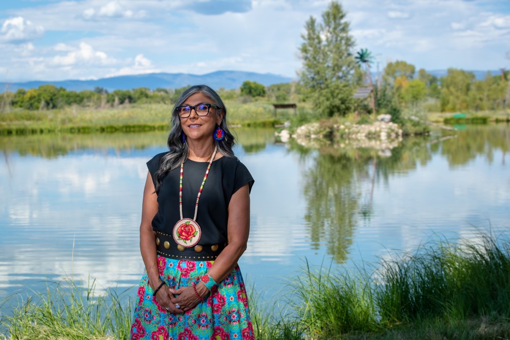
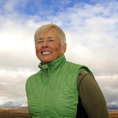
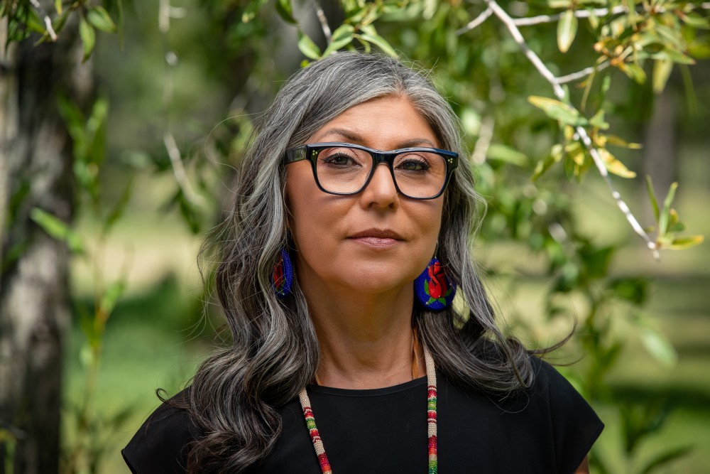
Lorelei Cloud, Vice-chair of the Southern Ute Tribal Council, and Southwest Colorado’s representative of the Colorado Water Conservation Board, which addresses most water issues in Colorado. Photo via Sibley’s Rivers
Lorelei Cloud, chair of the Colorado Water Conservation Board and co-founder of the Indigenous Women’s Leadership Network, cautioned against federal intervention. The federal government has fallen short of its trust responsibility to the tribes by failing to provide water, she said.
”All the people on the ground really need to step up and provide a solution,” she said.
Bill Hasencamp, manager of Colorado River Resources for the Metropolitan Water District of Southern California, said that federal intervention would mean reverting to pre-2007 operating guidelines under which water allocations are determined annually. That would make it harder for Metropolitan, which serves 19 million people across Southern California, to plan for the future.
“We might invest in sources that we don’t need, but also we may have to restrict water deliveries from time to time, as we’ve done in the past,” said Hasencamp. “For us, that’s a fail.”
But Tom Buschatzke, the director of the Arizona Department of Water Resources and the state’s lead negotiator, told Inside Climate News that federal leadership could break the deadlock between the states, a move that Arizona Gov. Katie Hobbs has called for recently.
Buschatzke feels that nothing the Upper Basin has proposed would withstand scrutiny from Arizona legislators, who would have to approve it. Visibly upset, he said the Upper Basin’s claim that they can’t take more cuts is “absurd” and is based on them not getting their “paper” water—a term used to refer to water that exists legally but has never been put to use or proven to currently be available.
“They need mandatory conservation that results in more water being in Lake Powell that can be moved to Lake Mead,” he said.
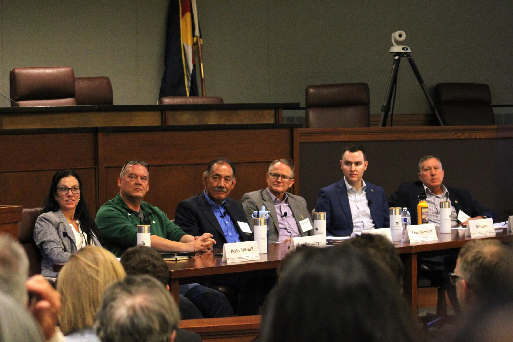
From left, J.B. Hamby, chair of the Colorado River Board of California, Tom Buschatzke, Arizona Department of Water Resources; Becky Mitchell, Colorado representative to the Upper Colorado River Commission at #CRWUA2023. Hamby and Buschatzke acknowledged during this panel at the Colorado River Water Users Association annual conference that the lower basin must own the structural deficit, something the upper basin has been pushing for for years. CREDIT: TOM YULSMAN/WATER DESK, UNIVERSITY OF COLORADO, BOULDER
Upper Basin negotiators counter that it is not their responsibility to cut their use to accommodate Lower Basin users who have long overdrawn the system. “We cannot subsidize overuse,” said Becky Mitchell, Colorado’s negotiator.
Lower Basin water use since 1964. 2025 data provisional, based on USBR projections Oct. 29, 2015.
At one point, the Lower Basin used several million acre-feet more water per year than it was allocated, but it has since reduced its consumption and now uses less than it is legally entitled to. California, the river’s biggest user, touted drastic conservation measures that have reduced water use to its lowest levels since the 1940s, despite booming growth in the state. Lower Basin leaders argue, too, that the region’s biggest cities, farms and economic outputs from the river are within the three states.
Upper Basin officials argue they have the right to grow as the Lower Basin has, and it’s unfair for those four states to sacrifice their future.
— Colorado River Water Users Association (@CRWUA_water) December 17, 2025
Earlier this week, leaders in both basins saw a preview of the federal government’s draft environmental review, which included a range of options for managing Lake Powell and Lake Mead. Some in the Lower Basin expressed concern that the options relied too heavily on them making future cuts. Hamby, California’s negotiator, emphasized that if the basin states eventually reach an agreement, it will determine how the federal government manages the river.
“Ultimately, none of it should matter if we get to a seven-state consensus,” said Hamby, who is also a board member of Southern California’s Imperial Irrigation District, the river’s single-largest water user. “But as part of the [environmental review] process, what we look forward to seeing from California is an equally balanced risk across the basin that motivates people to develop a seven-state consensus.”
Brandon Gebhart, Wyoming’s state engineer and Colorado River negotiator, called the analysis “broad enough to accommodate any seven-state consensus agreement” in an email.
Andrea Travnicek, assistant secretary for water and science at the Interior Department, said the government expects to publish the environmental impact statement in the last week of December or first week of January.
Despite the urgency, conference attendees weren’t surprised that negotiations remain stalled and no deal appeared imminent.
Cynthia Campbell, the director of policy innovation for the Arizona Water Innovation Institute at Arizona State University, said she expects one of two outcomes in the next 18 months, and perhaps both: the system will collapse or there will be litigation.
The public, she said, will then ask what happened, and leaders will have no good answers.
“I came with very low expectations, and they were met,” she said.
The Colorado River Basin spans seven U.S. states and part of Mexico. Lake Powell, upstream from the Grand Canyon, and Lake Mead, near Las Vegas, are the two principal reservoirs in the Colorado River water-supply system. (Bureau of Reclamation)
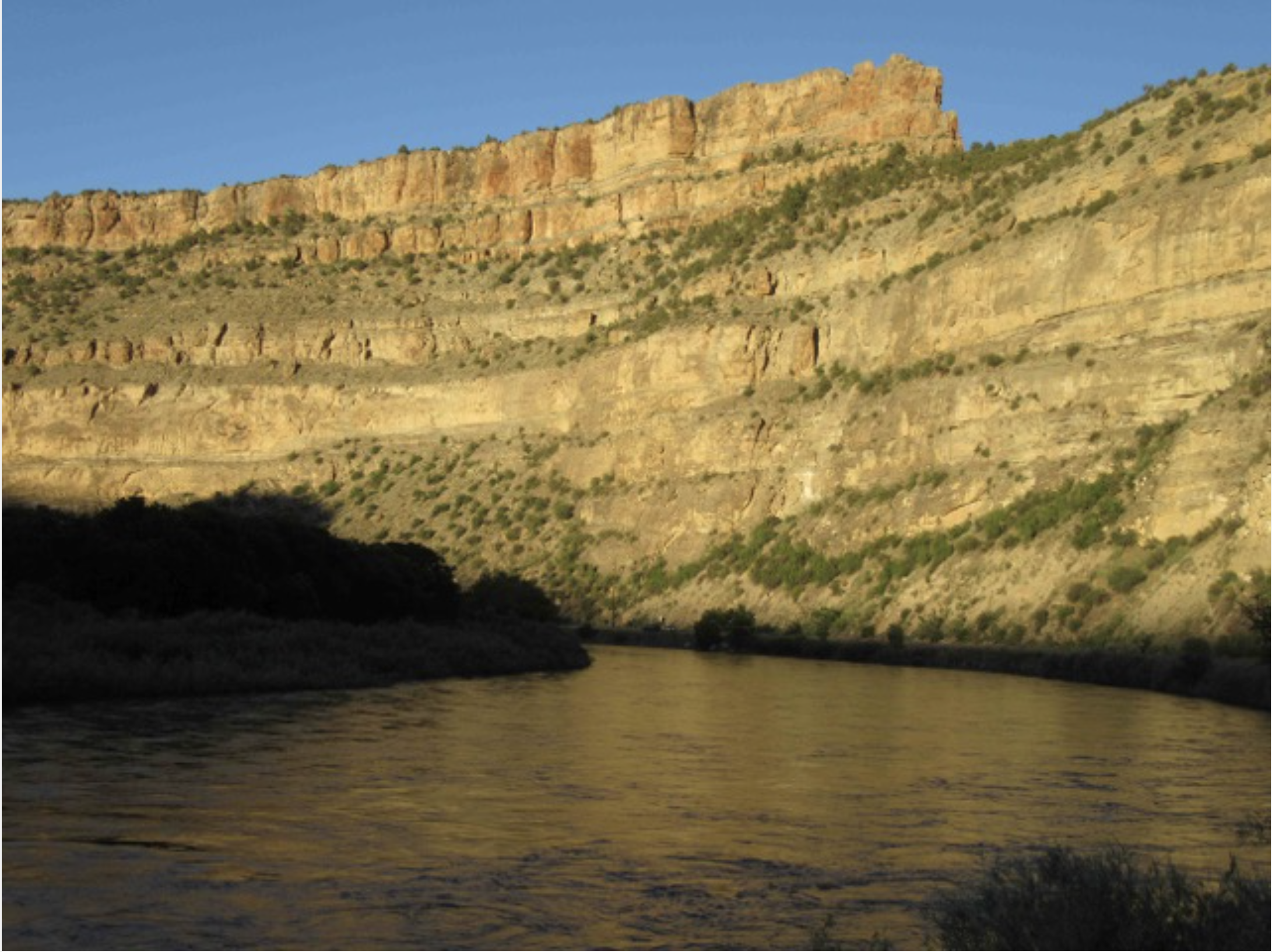
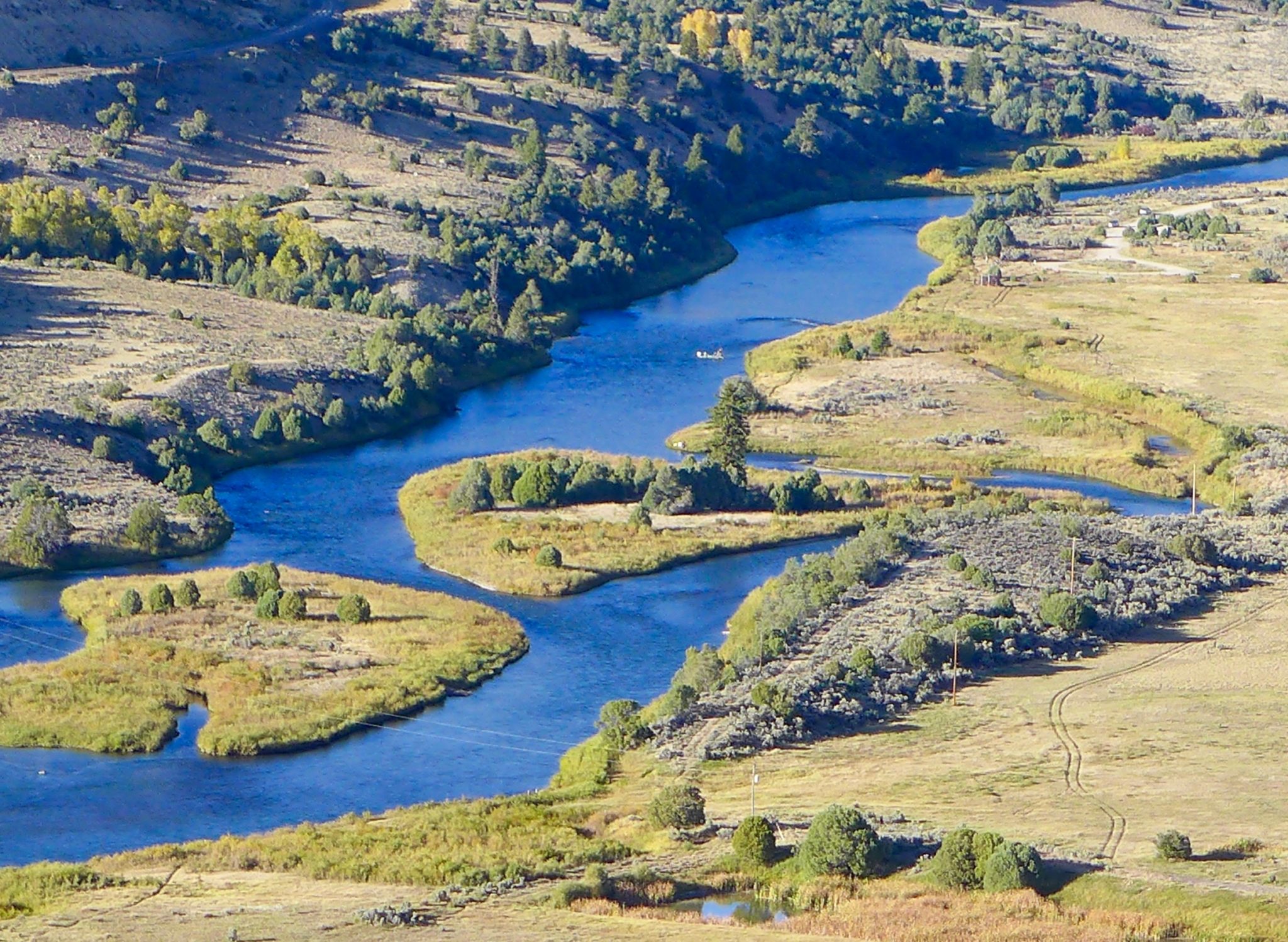
Colorado River “Beginnings”. Photo: Brent Gardner-Smith/Aspen Journalism
December 15, 2025
The effort to permanently protect the historic Shoshone water rights gained additional momentum as two more west slope communities committed funding in their 2026 budgets toward the Colorado River District’s $99 million purchase agreement with Xcel Energy. The Town of Breckenridge has pledged $100,000, and the Town of Gypsum has committed $15,000, underscoring the importance of reliable Colorado River flows for communities from the headwaters to the state line and beyond.
By committing financial support for the Shoshone Water Rights Preservation Project, Breckenridge and Gypsum join a large and growing coalition of Western Slope partners working to safeguard flows that support local economies, healthy rivers, and long-term water security for Colorado.
Breckenridge circa 1913 via Breckenridge Resort
“The Shoshone water rights are a cornerstone of the Colorado River system and a critical part of protecting our quality of life in the high country,” said Breckenridge Mayor Kelly Owens. “Breckenridge is proud to stand with partners across the West Slope and headwaters region to keep water in the river, support our outdoor recreation economy, and protect this vital resource for generations to come.”
Town of Gypsum via Vail.net
“Look, in Gypsum we see it every single day, our local ranches, our jobs, our families all depend on the Eagle and the Colorado running strong and flowing,” said Gypsum Mayor Steve Carver. “Backing Shoshone just makes sense. It gives us some certainty when water gets tight. We’re happy to jump in with everybody else and keep that water right here on the Western Slope.”
The Shoshone Water Rights Preservation Coalition, led by the Colorado River District, now includes 35 local governments, water entities, and regional partners across the Western Slope, as well as support from across the state. Together, these partners have committed over $37.3 million toward the $99 million purchase price, in addition to state and federal investments to protect a critical piece of Colorado’s water security.
“Communities across the West Slope continue to step up together in a powerful way,” said Andy Mueller, general manager of the Colorado River District. “Support from Breckenridge and Gypsum reflects a shared understanding that Shoshone is about more than one community or region. It’s about working together to keep the Colorado River and its tributaries flowing for the environment, agriculture, recreation and local communities across Colorado that rely on this water.”
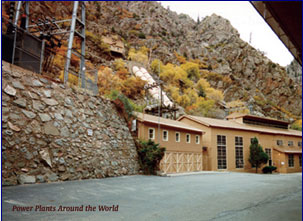
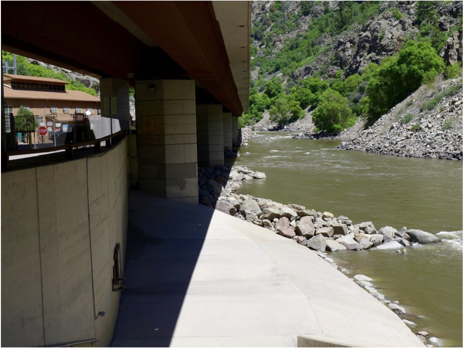
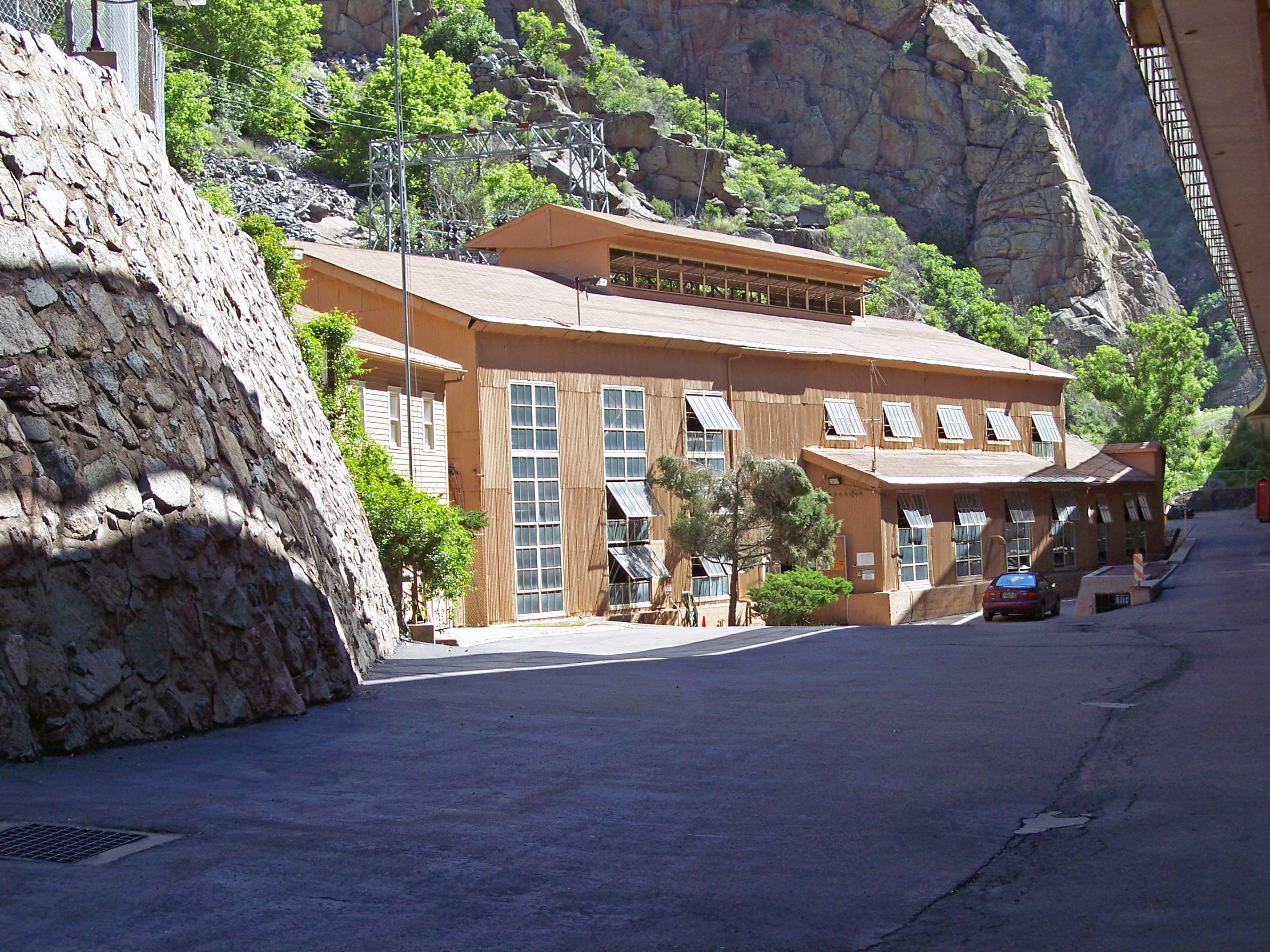
Shoshone Hydroelectric Plant back in the days before I-70 via Aspen Journalism
The Shoshone hydroelectric plant, located in Glenwood Canyon, holds nonconsumptive senior water rights that date back to 1902. These rights are essential for supporting flows in the Colorado River, benefiting agriculture, recreation, rural economies, and water users across the West Slope and beyond.
In December 2023, the Colorado River District entered a purchase and sale agreement with Xcel Energy to acquire and permanently protect the water rights, with plans to negotiate an instream flow agreement with the Colorado Water Conservation Board. This agreement would safeguard future flows, regardless of the Shoshone plant’s operational status.
In January 2025, the Bureau of Reclamation awarded $40 million in federal funding through a program authorized by the Inflation Reduction Act. The River District continues to work with the Bureau and remains optimistic that the project’s broad support and clear public benefit will secure the necessary federal funds to complete this once-in-a-generation investment.
Learn more about the Shoshone Water Rights Preservation Project & Coalition at KeepShoshoneFlowing.org.
The Colorado River Water Conservation District spans 15 Western Slope counties. Colorado River District/Courtesy image
This historical photo shows the penstocks of the Shoshone power plant above the Colorado River. A coalition led by the Colorado River District is seeking to purchase the water rights associated with the plant. Credit: Library of Congress photo
The acceptance of the Shoshone water rights marks a landmark partnership between the State of Colorado and the western slope.
Today, Wednesday, November 19, the Colorado Water Conservation Board (CWCB) voted unanimously to accept the joint offer by the Colorado River District and Public Service Company of Colorado (PSCo) of a perpetual interest in the use of the Shoshone Water Rights for instream flow purposes.
Once confirmed by water court, this acquisition will create the largest environmental water right in the state’s history and permanently protect the historic flow of the Colorado River.
“The importance of today’s vote cannot be overstated as a legacy decision for Colorado water and the western slope. It secures an essential foundation for the health of the Colorado River and the communities it sustains,” said Andy Mueller, General Manager of the Colorado River District. “We continue to be impressed by, and thankful for, the broad coalition of voices that have come together in support of protecting the Shoshone Water Rights. Without them, we would not have been able to meet this historic milestone.”
“Today, the CWCB demonstrated its deep commitment to Colorado’s water security by taking bold, permanent action to protect our namesake river. We are proud to stand with the State and with our many partners across the West Slope in securing these flows for the benefit of all Coloradans,” said Sen. Marc Catlin, president of the Colorado River District Board of Directors. “This agreement strengthens water security for hundreds of communities within our state and represents a proactive, durable solution for the 40 million people who rely on the Colorado River downstream. The Shoshone Water Rights Preservation Project keeps the river as whole as possible, keeping water in its natural basin and safeguarding this lifeline for generations to come.”
The board’s decision today was the final step in the instream flow acquisition process that began with the formal offer in May 2025. Following a contested hearing in September – requested by four Front Range water entities – the Colorado River District and PSCo granted the CWCB additional time to continue deliberations and fully consider the historic proposal and partnership at their November meeting.
35 entities filed for party status in support of the Shoshone Water Rights ISF proposal. These include West Slope towns and counties, water districts, as well as local and regional non-profits. Over 400 positive public comments were also submitted over the summer.
“Today’s decision by the CWCB is a tremendous step forward for the health of the Colorado River and the communities that rely on it,” said Senator Dylan Roberts. “The Shoshone Permanency effort reflects years of collaboration and a shared commitment to protecting our headwaters, and I’m grateful to all the partners who brought us to this point. There is still important work ahead, but this vote positions Colorado to take advantage of the years of effort and protects these flows for generations to come.”
“The Shoshone water rights are a lifeline for western Colorado,” said Mesa County Commissioner Bobbie Daniel. “Our farmers, ranchers, recreation enthusiasts, and energy producers depend on this water, and we are proud to see the CWCB support this project. These flows are the future of our families and communities, and now, more than ever, it is critical that we are doing everything we can to protect them.”
Xcel Energy provided the following statement: “Xcel Energy recognizes the significant collaboration and effort that brought us to today’s decision by the Colorado Water Conservation Board. We appreciate the engagement from all parties throughout this process and look forward to continuing the work ahead. This agreement represents an important step in ensuring reliable, clean energy for the communities we serve while supporting responsible stewardship of Colorado’s water resources.”
In December 2023, the Colorado River District and Public Service Company of Colorado (PSCo), a subsidiary of Xcel Energy, entered into a $99 million Purchase and Sale Agreement (PSA) to acquire the historic Shoshone Water Rights, senior (1902) and junior (1929) non-consumptive rights that stabilize flows on the upper Colorado River. The PSA is the product of decades of work by the statewide Shoshone Water Right Preservation Coalition.
To close the transaction, the PSA requires four conditions: execution of an Instream Flow Agreement with the CWCB (approved today), receipt of a water court decree approving the change of water rights, securing commitment of full project funding ($99 million), and approval from the Colorado Public Utilities Commission. So far, the Shoshone Water Rights Coalition has secured commitments of over $57 million from West Slope entities, the State of Colorado, and the Colorado River District’s Community Funding Partnership. The Bureau of Reclamation awarded the project $40 million through the Inflation Reduction Act Funds in January 2025 – those funds remain under review by the current administration.
Today’s CWCB decision fulfills that critical Instream Flow Agreement requirement, moving the project significantly closer to final completion and the permanent protection of the Shoshone flows. The River District, PSCo, and the CWCB will be initiating the water court process to add instream flow use to the Shoshone water rights. The River District and its full coalition of supporters will also be turning their focus on fully securing the previously awarded federal funds.
Colorado River Basin in Colorado via the Colorado Geological Survey
River District General Manager Andy Mueller speaks to the Colorado Water Conservation Board in front of a packed house Wednesday. The board voted unanimously to accept water rights tied to the Shoshone hydropower plant to benefit the environment. CREDIT: HEATHER SACKETT/ASPEN JOURNALISM
In a historic move Wednesday evening, the state water board voted unanimously to accept water rights tied to the Shoshone hydropower plant, a major step toward securing those flows in perpetuity for the Western Slope.
The Colorado Water Conservation Board said the Shoshone water rights, which are some of the oldest and most powerful on the mainstem of the Colorado River, can be used to benefit the environment.
“The Shoshone acquisition makes a lot of sense to me, and I’m very proud to be a part of the work that everybody’s put into it,” said Mike Camblin, who represents the Yampa, White and Green river basins on the CWCB. “I hope that our children and our grandchildren look back and realize we made the right decision on this.”
The Glenwood Springs-based Colorado River Water Conservation District plans to purchase the Shoshone water rights for $99 million from Xcel Energy, but the district first needed the approval of the CWCB, which is the only entity in the state allowed to hold instream-flow water rights to benefit the environment. Because the water is returned to the river after it runs through the hydroplant’s turbines, downstream cities, irrigators, recreators and the environment all benefit.
River District General Manager Andy Mueller called it a fantastic day in Colorado history.
“I think that was the right decision for the Colorado River and the right decision for our whole state,” Mueller said. “I think the state for generations to come, centuries in the future will benefit from having that water in the Colorado River.”
Importantly, the instream-flow agreement approved by the board says that the Western Slope, along with the CWCB, will retain some control over exercising the rights. The River District and its constituents drew a hard line in the sand regarding this point and said they would walk away from the deal if they had to cede control solely to the CWCB.
Though not totally unprecedented, co-management is a departure from the norm, as the CWCB has never shared management of an instream-flow water right this large or this powerful with another entity.
In attendance at Wednesday’s CWCB meeting in Golden were representatives of ditch companies, elected officials and water managers from across the River District’s 15-county area. Some of the attendees said during their public comments that if the River District didn’t retain some control over the water rights, they would pull their funding and withdraw their support from the Shoshone campaign.
Mesa County Commissioner Bobbie Daniel said the joint-management proposal is a safeguard that ensures that Western Slope interests are not pushed aside. Mesa County has committed $1 million toward the purchase of the water rights.
“The Shoshone call is one of the great stabilizing forces on the river, a heartbeat that has kept our valley farms alive, our communities whole and our economy steady, even in lean years,” Daniel said. “If a joint management is not adopted, Mesa County will withdraw its support for this acquisition. It’s not out of anger or politics, but because anything less would fail the people that we serve.”
The Shoshone hydropower plant in Glenwood Canyon has some of the oldest and most powerful nonconsumptive water rights on the Colorado River. A broad coalition of Western Slope entities support the River District purchasing the rights. CREDIT: HEATHER SACKETT/ASPEN JOURNALISM
Blow to the Front Range
The CWCB’s decision was a blow to Front Range water providers, who objected to the River District’s having a say over how to manage the water rights, even though they supported the overall goal of protecting flows for the environment. Denver Water, Northern Water, Aurora Water and Colorado Springs Utilities argued that the CWCB has exclusive authority over the rights, according to state statute.
Critically, because the Shoshone plant’s water rights — one that dates to 1902 for 1,250 cubic feet per second and another that dates to 1929 for 158 cfs — are senior to many other water users, they have the ability to command the flows of the Colorado River and its tributaries upstream all the way to the headwaters. This means that the owners of the rights can “call out” junior Front Range water providers with younger water rights that take water across the Continental Divide via transmountain diversions and force them to cut back.
The fact that Front Range water providers take about 500,000 acre-feet annually from the headwaters of the Colorado River is a sore spot for many on the Western Slope, who feel the growth of Front Range cities has come at their expense. These transmountain diversions can leave Western Slope streams depleted.
The Shoshone call pulls water west much of the time. But the Front Range parties wanted assurances that during extreme droughts or emergency situations, the call would be “relaxed,” allowing them to take more water to their cities’ millions of customers.
Alex Davis, assistant general manager with Aurora Water, said the CWCB should retain the ability to relax the call as a “backstop” under extremely rare circumstances.
“It is asking that in those emergency situations, the board has the ability to step in and say: We’re going to do what we think is best for the state of Colorado,” Davis said.
The agreement approved by the board lays out a collaborative process to consider a call relaxation, with a stakeholder panel of water managers from both sides of the divide. The specific wording of this agreement was hashed out during Wednesday’s meeting, with lawyers representing the CWCB and River District conferencing to tweak language and make edits.
Colorado Water Conservation Board member representing the Arkansas River basin Greg Felt, left, talks with River District General Manager Andy Mueller Wednesday after the board voted to accept the Shoshone water rights for instream flow purposes. The move represents a major step toward securing those rights in perpetuity for the Western Slope. CREDIT: HEATHER SACKETT/ASPEN JOURNALISM
The CWCB had been set to decide on the Shoshone rights at its meeting in September, but the River District granted an eleventh-hour 60-day extension so they could address issues raised by the board and try to negotiate a consensus with the Front Range parties.
Despite all the detailed arguments laid out by the parties, thousands of pages of technical and legal documents, and hours of testimony and public comment over the September and November CWCB meetings, the board’s scope of decisionmaking remained narrow: Should the CWCB accept a perpetual interest in the Shoshone water rights and will these rights preserve the natural environment to a reasonable degree?
In the end, the board decided yes, and also determined that it did, in fact, have the authority to allow the River District to co-manage the Shoshone water rights alongside it.
“I really think it’s pretty incredible that there’s no objection to the environmental aspects of this flow and the purpose of this water right for environmental purposes,” said CWCB Director Taylor Hawes, who represents the mainstem of the Colorado River where the Shoshone plant is located. “(The River District is) donating that water right. It seems like they should have a say. And while I realize this case is unique, I don’t see anything in the statute or the rules that prohibits us from doing this.”
But the fight to keep Shoshone flowing west is not over for the River District. The CWCB, River District and the water rights’ current owner, Xcel, now plan to file a joint application in water court to make the deal official by adding the instream-flow use to the water rights.
The water court process will decide another contentious issue that is sure to again highlight disagreement between the Western Slope and Front Range as they compete for the state’s dwindling water resources: precisely how much water is associated with the water rights, a number based on the plant’s past use.
“I also very much understand the concerns of both sides of the divide in not wanting the other side to have a windfall,” Hawes said. “That has been kind of the heart of all of this. And I hope we can all trust that the water court’s process will give us a result where we don’t have to worry about that. Everyone’s concerns will be addressed in that process.”
View of Shoshone Hydroelectric Plant construction in Glenwood Canyon (Garfield County) Colorado; shows the Colorado River, the dam, sheds, a footbridge, and the workmen’s camp. Creator: McClure, Louis Charles, 1867-1957. Credit: Denver Public Library Digital Collections
November 19, 2025, Golden, CO – This evening, the Colorado Water Conservation Board (CWCB) voted to approve the long-anticipated Shoshone water rights acquisition, to secure two water rights associated with the Shoshone Power Plant, including one of the state’s most significant Colorado River water rights, for permanent instream flow protection. The vote launches the next phase of the process, including water court, and begins the work of preserving and improving the 2.4-mile reach of the Colorado River between the Shoshone Power Plant Diversion Dam and Tunnel and the Shoshone Power Plant Discharge Outlets.
“Securing one of the state’s most significant Colorado River water rights for permanent instream flow protection is a momentous achievement,” said Lauren Ris, CWCB Director. “This outcome reflects a tremendous amount of work, from extensive technical analysis and stakeholder engagement to thorough regulatory review and legal preparation. This careful evaluation ensures our investment delivers long-term benefits for the river and for Coloradans.”
The agreement passed on a unanimous vote, with two directors recused. The decision follows the Colorado River District’s authorization of an extension from the September hearing to the November Board meeting, allowing additional time for review of the information presented and continued efforts to achieve a negotiated resolution of contested issues.
“I want to thank all the people who have worked so hard to inform this decision for the Board and the diverse range of stakeholders who earnestly engaged,” said Dan Gibbs, Executive Director, Colorado Department of Natural Resources. “Acquiring the Shoshone water rights for instream flow use is a once-in-a-lifetime opportunity to preserve and improve the natural environment of the Colorado River. But I also want to stress that the state is committed to ensuring that the historical use of the water rights is maintained at the status quo and we are committed to participating in any process to settle and resolve these issues for all water users. I am confident in our ability as a state and as a water community to come together in a way that is beneficial to all.”
Over the last two months, the CWCB and the Colorado River District met with Front Range entities and other interested parties to work toward resolving the issues raised at the September hearing. The next step in the process is the filing of an application in water court, for approval of the change of water rights to include instream flow use in a way that will not cause injury to decreed water rights.
This milestone follows significant commitments from the Colorado River District, local partners, and the CWCB, including the State’s $20 million Projects Bill contribution, to secure the long-term future of the Shoshone water rights.
This map shows the 15-mile reach of the Colorado River near Grand Junction, home to four species of endangered fish. Map credit: CWCB
Click the link to read the article on the Big Pivots website (Oliver Skelly):
November 18, 2025
Colorado water transfers rarely come easily. State water law ensures that every last drop of water is accounted for, litigated, and litigated some more.
It is no surprise then that the attempted Shoshone purchase by the Colorado River Water Conservation District has snagged on a couple of thorny legal and policy issues. Whether those issues will prove fatal to the purchase will be taken up at a meeting tomorrow afternoon, Nov. 19, in Golden.
The Shoshone rights
The transferred water rights from Xcel Energy to the Glenwood Springs-based River District have huge implications. Xcel uses the water rights for hydroelectric production at the Shoshone plant in Glenwood Canyon. The hydro plant produces relatively little power. As in real estate, though, location matters entirely.
Xcel’s water rights of 1902 and 1929 are senior to most other water rights upstream of Glenwood Canyon. They are also high-volume water rights, at 1,250 and 158 cubic feet per second, respectively. Additionally, they are entirely non-consumptive, meaning that all water taken out of the river (to spin the turbines) soon returns to the river for downstream use. As such, they have tremendous power to influence flows along the entirety of the Colorado River through Colorado.
If Xcel were to cease making electricity there, junior users upstream could divert more water. Many of those users would be the state’s transmountain diversions, which extend from Rocky Mountain National Park to Independence Pass. They benefit farmers and now mostly cities from Fort Collins to Colorado Springs. Any water that is diverted to the Front Range, however, is water that does not flow westward.
Because of this, both the River District and the Front Range diverters have had their eyes on those water rights for decades. What happens at Shoshone matters greatly both on the Western Slope, where the river naturally flows, and on the Front Range, where some of the river is now diverted.
Will the River District get that water right? It plans to keep the senior, high-volume hydropower water rights but also add an environmental instream flow right to the original decree, a class of water right approved by state legislators in 1973.
The district has already inked a purchase-and-sale agreement with Xcel and has raised $57 million of the $99 million price. It has been promised an additional $40 million from the Bureau of Reclamation, although the Trump administration has now frozen that money.
The Colorado Water Conservation Board (CWCB), a state agency responsible for water policy and funding, plays several major roles. In addition to agreeing to contribute $20 million, the CWCB has the sole authority under state law to own instream flow rights. For this deal to work, the River District also needs the agency’s board approval. That approval would seem to be a given because of the board’s commitment of $20 million to the purchase. But there are complications.
Not so simple
You are likely not shocked that Front Range water providers have not been thrilled with this pending transfer. In June, they asked the CWCB to hold a hearing to express their concerns.
At a September 19th meeting held on the campus of Fort Lewis College in Durango, the two primary parties testifying fell along predictable geographical lines: the Front Range (water providers) and the Western Slope (River District). CWCB staff also presented findings.
The question before the CWCB was a simple one: Does the acquisition “preserve the natural environment to a reasonable degree?” If the answer is yes, the water right is suitable as an instream flow right. By law, the board must consider 11 factors when making this determination. These factors are found in the instream flow law’s implementing regulations and range from whether this transfer will cause injury to other water users, the impact on interstate water compacts, and the cost of the transaction.
At the hearing, a host of messy realities surfaced. The first came after the CWCB staff presentation on the environmental importance of the 2.4-mile instream flow segment (i.e., whether the acquisition would in fact “preserve the natural environment to a reasonable degree”) in Glenwood Canyon.
The Front Range and Western Slope parties then trumpeted the many but competing public benefits afforded by the Shoshone rights: rafting in Glenwood Canyon, orchard irrigation at Palisade, hospitals in Aurora.
Public interest…in Colorado?
Nearly all other Western states have incorporated some form of public interest requirement during water transfers. Although a difficult term to pin down, public interest reviews involve the consideration of public goods, such as healthy rivers or recreational amenities. The presiding bodies, when evaluating transactions, must weigh the private interests against the broader public benefits (or lack thereof).
Colorado has no requirement. In 1995, the Colorado Supreme Court found the public interest theory conflicts with the prior appropriation doctrine. Without any legislative developments or a judicial about-face, that is that.
So, if we don’t have a public interest review, why the parade of testimony?
The most obvious answer is politics. When seeking approval (or denial) from an administrative body, it’s not a bad bet to show pretty pictures and tell compelling stories. But “politics” in this context can also be seen as a sub-in for those public interest principles.
The eighth factor governing the CWCB’s deliberations requires consideration of the “effect of the proposed acquisition on the maximum utilization of the waters of the state.” Maximum utilization and the public interest, although not direct parallels, both share a principle of the “greatest good.”
This backdoor introduction of the public interest gave listeners a glimpse of what the judicially disapproved principle might look like in Colorado water transfers.
Whose right is it, anyway?
That introduction at the hearing spurred perhaps the trickiest legal and policy issue of the day: Who has authority to enforce the instream flow agreement? That is, who can make the legal call instructing other water users to forgo their diversion so that the instream flow right gets its full water allocation. Is that a Western Slope political entity, the River District, or the statewide agency, the CWCB?
And if it is the CWCB, does it have authority to grant its enforcement power to the River District? While the law appears to say yes, the River District can be granted authority, there is enough ambiguity in the 1973 law to perhaps send this to Colorado Supreme Court.
The policy question, however, quickly returned parties to the realm of the public interest.
The Front Range parties, arguably the most averse to any sniff of public interest requirements, ironically now found themselves supporting the idea that the broader public benefits should be under consideration.
They contended that the CWCB should preserve its discretion to use and operate the instream-flow right. That, they said, would be sound public policy. Or if you will, “in the public interest.”
Meanwhile, the River District, as the purchasing party and longstanding practitioners of Colorado water law, understandably wants to get what they are paying for: full control over exercising their water rights. Retaining enforcement powers under the agreement was, in fact, “the one sword that the West Slope” was prepared to fall on.
Filings from both parties on Monday suggest that there is ongoing disagreement on this issue, meaning the CWCB will have a big decision to make.
The Colorado River flows through Glenwood Springs, paralleled by Interstate 70 and the Union Pacific tracks, at sunset in March 2024. Photo credit: Allen Best
Can’t you just compromise?
The next display of messiness came when it was time for the Board to apply the 11 factors.
To those listening, it was quickly apparent that such a contested hearing had not been before these board members before. Few of the directors seemed to understand how each factor was to be applied to the proposal in front of them. Although no fault of the board members, the misalignment between their understanding of their roles and the consequences of the decision to be made felt almost incommensurate.
That unpreparedness may have resulted in the Board’s parting directive to the parties to “compromise”: surely a favorable idea aimed at inspiring creative strategies and good faith negotiating.
But in the adversarial world of Colorado water law, what might result from this directive?
Such directives are common enough in water disputes. Recently, in the case of the Gross Reservoir expansion, a federal court, the 10th Circuit, told Denver Water and Save the Colorado to do the same.
In matters of purely Colorado domain, however, such directives are normally reserved as an outcome of the water court process. Ordering it before litigation seemed premature, perhaps even subversive.
The parties’ reactions were revealing here. The Front Range interests will certainly see it as a tally in their favor because it suggests the River District needs to move away from its hardline position. Perhaps their aversion to the public interest doctrine is not so set in stone, after all.
For the River District, it is hard not to imagine some frustration. This was a contracted-for acquisition under Colorado’s longstanding, private property water rights regime. But here, too, the water is muddy. Recall that the CWCB is providing 20% of the purchase price. What kind of leverage, tacit or otherwise, does that commitment provide?
Nov. 19th hearing
These are all difficult questions, and they are being asked amidst a backdrop of high stakes, interstate Colorado River negotiations. Answering them will be no easy feat, and as the filings on Monday indicate, those questions remain unanswered. Whether it is indeed a “compromise” at the CWCB meeting on Wednesday, Nov. 19, or back to the drawing board for the River District is anyone’s guess. But the uncomfortable positions and contortions on display at the contested hearing gave an insightful glimpse into the messy realities of today and stress tests of the future for Colorado water law.
Oliver Skelly is a 2025 graduate of the University of Colorado Law School, a former river guide, and follower of Western water happenings. He has worked at various law practices around Colorado and is now clerking for a judge on the Western Slope.
Colorado transmountain diversions via the State Engineer’s office
“As a people, we value water,” says Lorelei Cloud. “We know that water is sacred. We also know that water is alive. It has a spirit.” Photo Credit: Hans Hollenbeck
“If we take care of that water, we know that water is going to take care of us,” stated Lorelei Cloud, who has spent a lifetime advocating for water conservation and access. Cloud, a former vice chairman of the Southern Ute tribe, was also the first tribal member on record to serve on the Colorado Water Conservation Board. On Thursday, Nov. 6, The Arts Campus at Willits (TACAW) hosted Cloud and a fellow trustee of The Nature Conservancy (TNC) Colorado, Johnny Le Coq, for a presentation on their respective backgrounds and water conservation work. The event, sponsored by Roaring Fork Conservancy and TNC, was a special installment of the Brooksher Watershed Institute. Lawyer Ramsey Kropf, who has decades of experience in representing Indian water rights cases in the Colorado and Klamath River basins, emceed.
After some brief introductions, Cloud opened the evening by sharing the history of her people. The Roaring Fork Valley is part of ancestral Ute territories. Though the Utes, who referred to themselves as “Nuche,” or “the people,” and called their home the “Shining Mountains,” were seasonally nomadic before the arrival of colonial miners, Cloud shared that her people do not have a traditional migration story as some Indigenous peoples do. What the Nuche have is a creation story that ties them intrinsically to the soaring peaks and waterways of the Colorado Rocky Mountains. Cloud explained that the seasonal nomadic moves of the Nuche were not considered to be migration but normal shifts, demonstrating respect and care for the ecosystems…
“We believe that we are one and the same with nature,” Cloud said, elaborating that other species and even elements like water are akin to souls.
With a newly approved grant of over $30,000 from the Colorado Basin Roundtable, the Blue River Watershed Group will install cameras and measuring devices on the river to report on stream conditions.
A news release stated the group will use a technical consultant to create a webpage with a community-facing geographic information system map to share water quality data, as well as information about how the data affects the Summit County community.
The database will share locations, data types, collection purposes and data quality objectives from each of the Blue River watershed’s collecting entities.
The grant was part of the more than $180,000 of spending the Colorado Basin Roundtable approved in its September meeting. The rest of the money is funding projects around the state.
The Colorado Basin Roundtable has awarded $20,000 to Rivers Edge West and the Desert Rivers Collaborative to support restoration planning and coordination in the Gunnison and Colorado river basins, according to a news release. De Beque received $50,000 for improvements it is making to its 24.4-acre River Park on the Colorado River. Rivers Edge West and the Desert Rivers Collaborative plan to use their money to help identify priority restoration sites, develop a geospatial database and story map, and contribute to regional initiatives including the Grand Valley River Corridor Initiative, supporting health riparian ecosystems in Mesa County, according to the release. De Beque received the $50,000 to support engineering and design work needed for riverbank stabilization. The park is going to include an amphitheater, pavilion, parking areas, boat ramp and arboretum…Other allocations approved by the roundtable are:
$15,000 for the Middle Colorado Watershed Council’s Grand Tunnel Ditch flume replacement project;
$30,600 for the Blue River Watershed Group’s Blue River water quality monitoring dashboard and GIS resources;
$30,000 for the Eagle River Coalition’s Homestake Valley stream crossings project;
$30,000 for the Center for Snow and Avalanche Studies, for dust-on-snow data collection and cosmic ray evaluation, with this funding being contingent on the project receiving similar support from the state’s eight other basin roundtables.
In an era where climate change and overconsumption threaten our waterways, a remarkable act of generosity and foresight has emerged from the Indian Peaks Wilderness area of Colorado. On August 29, 2024, an anonymous donor gifted Jasper Lake, including the parcel of land surrounding it and the senior water rights it stores, to the Colorado Water Trust. This marked the largest water donation in Colorado’s history. This act ensures the protection of 37 miles of Boulder Creek, safeguarding its flow, ecosystems, and recreational value for generations to come. Since 2024, 100 million gallons of water have been restored to the river as a result of this donation, and the annual benefit will continue to accrue to Boulder Creek streamflow indefinitely.A warming climate will continue to put pressure on Boulder Creek, but this source of water will be protected forever.
Over the past 25 years, the Colorado Water Trust has restored 27 billion gallons of water to 814 miles of rivers and streams throughout Colorado. Here is how it works: Much like a land trust can invest in conservation easements to protect property for future generations, the Colorado Water Trust invests in water rights to protect streamflow in our rivers. Water in Colorado is not only the lifeblood of our state and economy, but the right to use it can also be bought and sold. Instead of diverting water out of the river, the Water Trust uses water rights to protect that water in the river.
In the western United States, where water scarcity is an ever-pressing reality and climate change threatens to exacerbate hydrological extremes, the permanent donation of storage water from Jasper Lake to environmental benefit marks a profoundly important milestone. This is not merely a gift of water; it is a precedent-setting, visionary act that fuses water law ingenuity, ecological foresight, and an ethic of stewardship. In an era dominated by competing interests and escalating scarcity, the Jasper Lake donation offers a replicable path forward for other Western states grounded in cooperative frameworks, legal adaptability, and the kind of selfless generosity that serves the public interest.
Jasper Lake Donation
In 1890, nearly a century before Congress designated the Indian Peaks Wilderness as a part of the nation’s Wilderness Preservation system, the Boulder High Line Canal Company constructed Jasper Reservoir. Known to hikers and wilderness visitors as Jasper Lake, the reservoir has been a source of agricultural water in Boulder County and areas east of the mountains since that time. Nestled just east of the Continental Divide, this enclave for cold-water fish, moose, and backpackers doubled in purpose. Irrigation companies and the Colorado Power Company operated the reservoir over the next century.
Since the 1890s, Jasper Lake has been in a series of private ownerships, having been bought and sold multiple times. In recent years, the City of Boulder leased Jasper Lake water from private owners and provided that water to various Boulder County irrigators. During that time, the Colorado Water Trust worked with the owners of Jasper Lake to craft a plan for its use for environmental improvements and public benefit. As these conversations progressed, the owners generously offered Jasper Lake as a donation to the Water Trust.
The Water Trust then sought out a steward for the reservoir with both the capacity and knowledge necessary to manage and maintain the reservoir’s infrastructure. While the Water Trust owns multiple water rights, it focuses its time and energy on transactions that boost streamflow. Finding the right steward—one who would commit to using Jasper Lake water in environmentally-compatible operations—would free the nonprofit from the burden of operating a high-hazard dam while meeting its mission to add water to Colorado’s rivers. Accordingly, the Water Trust sought a partner with a desire to uphold the environmental and community values vital to operating Jasper Lake in a way that complements the mission of the Water Trust. Luckily, the nonprofit found such a willing steward and partner in the Tiefel Family.
The Tiefel Family, long-time residents of Colorado, have a deep-rooted connection to the state’s natural landscapes and water resources. Known for their unwavering commitment to environmental preservation, the Tiefel Family has dedicated themselves to protecting Colorado’s vital water ecosystems. With a passion for ensuring that future generations can enjoy the natural beauty of Boulder Creek and its surrounding areas, the Tiefel Family established 37-Mile LLC. Named after the length of protected streamflow from Jasper Lake through the wilderness and down Boulder Canyon, 37-Mile LLC is a testament to its mission of safeguarding the region’s water resources from development pressures while promoting sustainable agricultural and irrigation practices.
“Our stewardship of Jasper Reservoir aligns with our broader vision of environmental conservation and community enrichment,” said Doug Tiefel of 37-Mile LLC. “The family is honored to partner with the Colorado Water Trust to ensure that the reservoir’s water continues to benefit the local ecosystems and communities, reinforcing our legacy of environmental responsibility.”
Jasper Reservoir/Boulder Creek. Credit: Colorado Water Trust
With the support of the Tiefel Family and 37-Mile LLC, the Colorado Water Trust entered into an arrangement that benefits all involved. After the Water Trust accepted the reservoir donation, 37-Mile LLC entered into a purchase agreement to acquire the reservoir subject to a public access easement and a set of restrictive covenants that permanently protect public access to the reservoir and ensure that water released from Jasper Lake will continue to provide environmental benefits well into the future. As an additional benefit, once the water has traveled through Boulder Canyon and to the plains, agricultural producers can then use the water downstream.
The Jasper Lake water donation is truly exceptional in its structure and intent. The reservoir is ideally positioned at high elevation with a long carriage distance, benefiting stream flow in a highly visible and environmentally conscious area like Boulder Creek. The ability for a secondary use downstream for agricultural benefit further enhances its value. Most environmental water transfers have historically involved direct flow rights—typically less reliable and subject to seasonal variability. What makes Jasper Lake unique is that it involves the donation of storage water, which is highly reliable and valuable. Unlike junior water rights that may or may not be available in a dry year, this donation ensures actual wet water in the stream, when and where it is needed.
Through a uniquely cooperative agreement involving the Water Trust, a generous donor, a family with strong farming and ranching ties to the region, and planning support from the City of Boulder, this donation not only protects two critical components—agricultural heritage and instream ecological health—but also creates a new archetype for interagency collaboration. The result is a permanent, flexible, and legally sound environmental asset that will benefit both the creek and downstream users in perpetuity.
This project involving Jasper Lake and its water rights represents a new concept in water management, one that the Water Trust hopes to replicate many times in the future. It proves out the potential for the prior appropriation system to rise to meet environmental challenges without the application of an administrative public trust regulatory layer. The biggest challenge is financial. These are market-based transactions and so the Water Trust must either accept donations or be prepared to make competitive offers to be able to acquire permanent public access, remove development potential, and safeguard environmental benefits.
How the Water Trust was Formed; Colorado Water Law 101
Some of the best legal minds in Colorado and the West meticulously brewed the initial notion for a nonprofit trust that would utilize water rights for environmental benefit. The Water Trust was founded in 2001 by water rights scholar David Getches and now-retired water attorneys Michael Browning and David Robbins. Browning, who was the first chair of the board credits the initial concept being introduced by fellow law colleague Larry McDonnell, who was also on the faculty at the University of Colorado Law School. With early guidance from David Harrison, the Water Trust has grown from a fledgling nonprofit to a respected water rights innovator, facilitating over sixty transactions that have restored millions of gallons to rivers and streams across Colorado.
The Water Trust emerged from the recognition that the prior appropriation doctrine, often seen as rigid and zero-sum, could be creatively applied to benefit rivers. The Water Trust set out to proactively secure senior water rights for instream flows in collaboration with the Colorado Water Conservation Board (CWCB), a state agency that holds the exclusive authority to place water to the beneficial use of instream flow in the State of Colorado as a way to preemptively address concerns about the future of the doctrine. Colorado has been a pure prior appropriation state since even before the 1873 Centennial State ensconced the practice in its constitution. Known as the “Colorado Doctrine,” a set of laws that the Territorial legislature passed in the 1860s established that:
The state’s surface waters and groundwaters constitute a public resource for beneficial use by public agencies, private persons and entities;
A water right is a right to use a portion of the public’s water supply;
Water rights owners may build facilities on the lands of others to divert, extract, or move water from a stream or aquifer to its place of use;
Water rights owners may use streams and aquifers for the transportation and storage of water.
The Water Trust operates squarely within the strict prior appropriation structure that the Colorado Doctrine established. In some western states, such as California, the public trust doctrine has been recognized to create an affirmative duty of state government to act as legal guardian for natural resource assets, including streams and rivers. Colorado, however, has remained a pure prior appropriation state since the 1800s.
The creation of the CWCB instream flow program in 1973 was an environmental era attempt to address streamflow issues without creating an exception to prior appropriation. As the federal government legislated into law environmental measures including the Clean Air Act and the Clean Water Act, the State of Colorado ensured that water right administration and the practice of prior appropriation would remain untouched by federal environmental measures. However, the initial CWCB instream flow program was not effective enough in protecting streamflow. At the outset, the CWCB’s instream flow program could only appropriate junior water rights and acquire senior water rights at minimum stream flow rates “necessary to preserve the environment to a reasonable degree,” which were often insufficient for genuine environmental protection. This shifted in 2002 when the legislature enabled the CWCB to acquire senior water rights and change their use to instream flow in water court, achieving more reliable priorities and stream flow rates “to improve the environment to a reasonable degree.”
Still, by the turn of the Century, the CWCB had acquired only a handful of senior water rights for instream flow use, and consequently, not all Coloradans found the state instream flow program to be satisfactory. Citizen-led groups had proposed multiple ballot initiatives, but each had failed to recognize one form or another of public trust in Colorado. Michael Browning explained that the Water Trust’s formation in 2001 was partly a response to concerns surrounding the public trust doctrine and its potential impact on established water rights in Colorado. The founders of the Water Trust aimed to acquire senior water rights voluntarily and work with the CWCB to convert them to instream flow use, preserving their priority dates. The founders understood that acquiring senior priorities for instream flow water rights was key to both meeting environmental priorities and safeguarding the prior appropriation system in an era where many people value sustainability and recreation equally with consumptive water use.
Key early strategies involved acquiring agricultural water rights and partnering with the CWCB for holding and applying them to instream flow use. Browning described the initial concept of purchasing existing water rights for agriculture and converting them to instream flows. The founders sought input from environmental and agricultural groups to ensure they wouldn’t be seen as a threat and engaged with the CWCB to navigate the politics of instream flows. Over time, the Water Trust strategy has expanded to include acquisition of reservoir rights like Jasper Lake and exploring ancillary uses such as downstream agricultural application, with environmental benefits accruing on a stream reach but no instream flow use per se.
It has always been crucial for the Water Trust to be perceived as working within the prior appropriation water rights system and not as a radical group trying to undermine it. From the outset, the Water Trust has committed to voluntary transactions and working through water courts. The initial board consisted of water engineers and lawyers, with an effort to include representatives from agriculture. Browning noted that there were initial fears from some in the water community, but the board’s credibility helped alleviate opposition. Over time, the Water Trust has grown from a small, Denver-based nonprofit to an influential statewide organization, with staff in the Upper Arkansas Basin and southwest Colorado, establishing roots in the communities where it has the greatest impact.
The first Water Trust acquisition of the Moser Water Rights on Boulder Creek near the Blue River was instructive. A retiring ranching couple wanted to protect their land under conservation easements, but then discovered they could also protect their senior water rights to benefit the environment. Their senior water rights gained a dual-purpose when the Mosers’ collaborated with the Water Trust: CWCB-facilitated instream flow for the creek, and downstream augmentation supply for the Colorado River District, stored in Wolford Mountain Reservoir. The initial funding for the first water right purchase was primarily private, with the water right costing around $15,000. A significant turning point was the involvement of the Walton Family Foundation, which provided substantial grants allowing the Water Trust to grow and hire staff, including Amy Beattie as its first full-time executive director. Linda Bassi, Chief of the Instream Flow program for the CWCB, was also a key supporter, recognizing the opportunity to enhance the seniority of instream flow rights. The Water Trust developed a partnership with the CWCB—the Water Trust would work with water right owners to purchase water rights and develop streamflow restoration projects, and the CWCB would hold and operate the acquired water for instream flows.
Case studies such as the Little Cimarron River transfer further highlight the Water Trust’s innovative model. In that project, water rights were split to allow both early-season irrigation by the landowner and late-season instream flow use by the CWCB, satisfying both agricultural and environmental needs without the typical winner-takes-all approach. This was the first “split-season” use of water for both irrigation and instream flow approved in Colorado water court. Nuanced arrangements like this have allowed the Water Trust to earn the confidence of landowners, water users, and government entities alike.
How the Water Trust has Adapted; Water Law 201
Under the Prior Appropriation Doctrine, water rights are governed by “first in time, first in right.” While this doctrine has often been characterized as overly rigid, seasoned attorneys—such as the late Colorado Supreme Court Justice Greg Hobbs and others—have long shown how water rights can be changed for new uses while maintaining senior priority. As Hobbs is purported to have said, and as board members and staff attorney for the Water Trust have expressed: We’ve done this forever for our clients… now let’s do it for our rivers.
Colorado law permits changes of use to be decreed by its water court, provided there’s no injury to other vested and decreed water rights. Changing a water right requires limiting the use to historical consumption and diversion patterns in time, place, and amount. The change process is cumbersome, often requiring tens of thousands of dollars in legal and engineering fees in addition to multiple years to usher a water court application from start to finish. However, the end result is essential for water users who need a reliable supply, because the seniority, or date of appropriation assigned to a water right originally, is maintained throughout the change of use process. Historically, an overwhelming proportion of these transfers have involved shifting water from agriculture to municipal or industrial uses. In recent years, and thanks in part to the fortitude of the Water Trust and the CWCB, instream flow rights transfers have grown to become 1% of water right changes statewide. While the shift is small, it has transformed rivers like the Little Cimarron and the Alamosa, adding flowing water back into riverbeds that were once unseasonably dry. It signals that environmental uses are not second-class claims but essential components of modern water management.
The Jasper Lake donation exemplifies this principle. The donor, instead of selling the valuable storage water on an open market, permanently gifted it for environmental use—a use now recognized and legally protected under Colorado law. And it was not only the generous donor who has supported their local stream system—37-Mile LLC as the buyer agreed to a set of strict covenants, essentially stripping the Jasper Lake water right of its development potential. This donation operates within the same legal framework as the early consumptive use transfers, including the Moser and Little Cimarron water rights, proving that environmental values can thrive without rewriting the rulebook.
Borrowing from Land Conservation Practices to Save Rivers
The water from Jasper Lake is not just turned loose; it is released into Jasper Creek, from which point it flows down 37 miles of Middle Boulder Creek and Boulder Creek before the Tiefel Family diverts it back out of the stream system for irrigation use. Unlike many Water Trust projects, there is no CWCB instream flow use of the water. Instead, the Water Trust ensured that the water would remain in Boulder Creek by choosing to partner with 37-Mile and requiring, as a condition of their partnership and sale, that 37-Mile would agree never to redivert the water until it reaches that 37-mile point, in addition to several other restrictions.
The restrictions that the Water Trust imposed include restrictive covenants and a public access easement—legal constructs adopted from land use law. Applying these principles, the property and water rights are permanently tied to ecological and public uses, while still respecting historical agricultural use for the Jasper Lake water. This flexibility was a key component that made the donation viable and attractive, and avoiding water court for a change of use enabled the participants to save on costs and time. The protections that the Water Trust tied permanently to Jasper Lake, the parcel of land surrounding it, and the water rights stored in it include the following:
An easement allowing the public to access Jasper Lake and the parcel of land surrounding it. Colorado law limits the liability of landowners who hold title to inholdings on public lands provided there is signage, which was key to the ability of 37-Mile to take on this responsibility;
Jasper Lake water must be stored until at least August 15 of each year, which provides the public with an opportunity to enjoy the beauty of its waters;
The owner of the Jasper Lake water right must take water deliveries beginning on or after August 15 of each year, which ensures that flows in the Boulder Creek drainage are boosted after snowmelt, when fish and the environment need it most;
The owner of Jasper Lake must take steps to avoid abandonment of the water right;
The owner of Jasper Lake must allow Colorado Parks and Wildlife to stock the lake with fish; and
Finally, if the owner of Jasper Court ever goes to water court, they must consult with the CWCB regarding the possible addition of instream flow use to the water right.
The covenant model ensures that the ecological intent of the donation is locked in perpetuity, regardless of future ownership changes. This legal durability is critical in an age of shifting climate variability and volatile hydrology. Moreover, the Jasper Lake donation includes an engineering-informed management plan that allows for strategic releases during critical low-flow periods, providing adaptive benefits for aquatic species, riparian vegetation, and downstream users. It is this combination of legal permanence and operational flexibility that makes the model so powerful.
Why Storage Matters: True Volume, True Impact
Storage rights, especially those high in the drainage area like Jasper Lake, offer great flexibility in release and can be timed to supplement flows when needed most. The long carriage distance of Jasper’s releases down Boulder Creek allows for significant stream flow restoration. Storage water can be released during dry seasons when streamflow is lowest, directly improving water quality, mitigating temperature spikes, and sustaining aquatic life. As the old adage goes, “The solution to pollution is dilution.” More water in the stream doesn’t just benefit fish and bugs; it improves drinking water quality for downstream communities and strengthens overall watershed health.
This is a crucial point: while senior direct flow rights can sometimes provide benefit when left in the stream, they often do so inconsistently. Stored water, by contrast, provides discretely measurable volumes that can be scheduled and managed. This transformed the Jasper Lake donation from a gesture to a guaranteed outcome. Drinking water providers, such as those in the Boulder and Denver metro areas, depend on baseflows to keep treatment costs low. High-quality source water means fewer chemicals and less energy to meet Safe Drinking Water Act standards. In this way, streamflow restoration becomes an upstream investment in downstream public health.
Perhaps most importantly, leaving water in the river should be understood not as a passive default, but as an affirmative beneficial use. Traditionally, beneficial use has been defined through diversion—water being taken out of the river for agriculture, industry, or municipal supply. But Colorado law now affirms that instream flows can meet the beneficial use standard when they are legally protected and used to preserve the natural environment. This conceptual shift is profound. It re-centers the health of the river itself as a priority, recognizing that a flowing stream provides ecological services, supports recreation economies, enhances water quality and sustains life throughout the basin.
Why Permanence Matters: Creative and Collaborative Solutions
What makes the Jasper Lake donation especially promising is its emphasis on collaboration. Governments, nonprofits, agricultural stakeholders and local communities worked in unison to ensure the project’s success. Each party brought their priorities to the table—agricultural heritage, legal acumen, ecological resilience—and emerged with a better outcome than any could have achieved alone.
There are few other legal mechanisms in Colorado to protect water for the environment: RISIDS (Recovery Implementation for Endangered Species), Wild & Scenic River designation (with only one such stretch in Colorado), or narrowly focused instream flow rights used by the CWCB. The Jasper Lake project expands this limited toolbox, showing that partnerships and legal creativity can yield conservation outcomes without requiring federal mandates.
Another instructive comparison is the Water Trust’s work on the Yampa River system, where cooperative agreements among the CWCB, environmental organizations, and agricultural users have led to temporary instream flow leases and beneficial use deliveries to preserve flows during dry years. These leases, though helpful, are inherently limited by duration and uncertainty. That uncertainty is, at least to some extent, mitigated by the existence of the Yampa River Fund, an endowed and locally-managed fund that pays for water leasing and sponsors other work to improve the Yampa River and its tributaries. Jasper Lake moves even beyond that, embedding conservation in perpetuity.
A Model for the West
Twenty-nine states operate under some form of the prior appropriation doctrine. The Jasper Lake donation stands as a model that others can emulate. Michael Browning said he still sees great opportunities for similar initiatives in other western states, especially those in the Colorado River Basin, emphasizing the role of nonprofits in adapting the water rights system to recognize environmental and recreational values. By demonstrating that private rights can be permanently converted to public goods—without litigation, without legislative overhaul, and without harming other users—this project charts a replicable path forward.
While unique in the seven states of the Colorado River Basin, the Water Trust is not alone. The Oregon Water Trust, founded in 1994, and the Washington Water Trust, founded in 1998, are similar organizations. There is an Arizona Water Trust that primarily focuses on land donations that may include water rights. Montana, New Mexico, and Utah have all explored instream flow programs, but few have integrated storage donations. In the Upper Snake Basin of Idaho, a pilot effort to lease stored water for environmental flows is promising, but still temporary. Jasper Lake shows that permanent storage donations are possible, legal, and immensely beneficial. Especially in the seven basin states, the Colorado Water Trust serves as a useful model and tool for others to replicate.
Lessons Learned
Perhaps the most profound lesson from Jasper Lake is the value of permanence. One-time leases and short-term mitigation projects are common, but they do not provide the stability or reliability that rivers need. Permanency ensures predictability. It signals to ecosystems and economies alike that someone is planning for the long term.
Moreover, the donation sets a precedent that stored water can and should be used for instream benefit—and that such uses are not just legally viable but deeply beneficial to the broader hydrological system. As we consider future projects, the importance of true volume, collaborative administration, and permanence cannot be overstated.
Another key takeaway is the importance of patience. Water transactions require time—not just to navigate the legal and engineering hurdles, but to build the trust among stakeholders that makes such projects durable. Funders, partners, and policymakers must embrace this long view. Water transactions require the same patience and investment mindset we bring to ski areas, resorts, transportation, reservoirs or other large infrastructure projects. But the payoff—cleaner rivers, healthier ecosystems, and stronger communities—is well worth it.
Gratitude and Foresight
As Michael Browning said, “Progress is possible with goodwill and a shared need.” The Jasper Lake donation is more than a gift. It is a template, a catalyst, and a moral benchmark. It shows that with legal creativity, trust among partners, and courageous donors, we can build a more resilient and ecologically rich future.
As the West grapples with aridification and changing demands, projects like Jasper Lake shine like beacons. They show us what is possible when we work together and think beyond ourselves. None of this would be possible without the extraordinary foresight and generosity of the donor. In a market where water rights fetch increasingly high prices, the choice to donate—permanently, and without reservation—is not only rare but deeply courageous. It reflects an ethic of care that transcends personal gain and speaks to a commitment of legacy, community, and the natural world.
The success of the Colorado Water Trust also reflects gratitude for the legislative frameworks that made it possible. Colorado’s instream flow program, the CWCB’s administrative role, and the legal structure built into prior appropriation water law all played essential roles. The Jasper Lake project didn’t require new laws; it simply needed the right vision and the will to collaborate. All it required was to Just Add Water.
Jasper Lake is truly a remarkable and historic gift.
Kate Ryan is a water lawyer who joined Colorado Water Trust in 2018 and was appointed as Executive Director in 2023. Her past clients included farmers, ranchers, municipalities, landowners, and the CWCB. Before going to Berkeley Law she obtained a master’s degree in geography at the University of Colorado. Kate does her work at the Colorado Water Trust in order to support that which she holds most dear–our incredible state and the people within, the beautiful rivers and mountains we explore, and a future for her kids where they can experience a continuation of it all.
Matt Moseley is a communication strategist, author, speaker and world-record adventure swimmer. He is the principal and CEO of the Ignition Strategy Group, which specializes in high-stakes communications and issue management. As the author of three books and is the subject of two documentaries, he uses his swimming around the world to bring raise awareness about water issues. He is the co-chair of the Southwest River Council for American Rivers and is a member of the Advisory Board for the Center for Leadership at the University of Colorado at Boulder. He lives in Boulder with his wife Kristin, a water rights attorney and their two children.
A rainstorm moves across Weld County on July 16, 2025. Cloud seeding technology could add more rain to farm fields in the area. Colorado officials said it will be the first time warm-weather cloud seeding is deployed in the state. Lucas Boland/KUNC
Click the link to read the article on the KUNC website (Alex Hager):
October 10, 2025
This story is part of ongoing coverage of water in the West, produced by KUNC in Colorado and supported by the Walton Family Foundation. KUNC is solely responsible for its editorial coverage.
A technology to increase rainfall is coming to Colorado for the first time.
A Florida-based company is setting up cloud seeding equipment to add water to some fields in Weld County. The company behind the project — and the state agency that permits it — hope that this rollout of what’s known as warm-weather cloud seeding is the beginning of a larger trend.
Andrew Rickert, weather modification program manager with the Colorado Water Conservation Board, called this cloud seeding project a “trial run.”
“We’ll see how the locals like it,” he said. “If they’re getting more rainfall and getting more crops, I can see this definitely catching on and spreading around the state, especially in these times of drought.”
Rickert said the technology can increase annual rainfall by 15 percent to 17 percent.
While the work to boost rainfall is new, according to Rickert, Colorado has run cold-weather cloud seeding technology for years. By adding snow in the state’s mountains, that work is aimed at increasing the amount of water in rivers during the spring melt. It is funded by the state and is only possible when temperatures are below freezing.
Warm-weather cloud seeding uses technology that originated in the 1950s and has been deployed in countries such as China, Jordan and Oman, as well as the state of Texas. It does not use chemicals or aircraft, like some forms of cold-weather cloud seeding. Instead, it sends out an electrical charge from the ground that can cause small, naturally-occuring particles to ascend into clouds and make water condense and fall as rain.
Rain falls in Summit County, Colorado on August 26, 2025. Colorado officials and the Florida-based company installing the cloud seeding equipment hope this Weld County trial run will be the beginning of more rain enhancement around the state. Alex Hager/KUNC
Some programs to add more snow have received backlash related to their use of silver iodide, which experts say has been proven safe through decades of testing. Randy Seidl, CEO of Rain Enhancement Technologies, said warm-weather cloud seeding does not use any chemicals and may be quicker to catch on.
“We’re hoping to show some success and then expand,” Seidl said.
The demo program run by Seidl’s company would be different from snow cloud seeding programs in Colorado, which are generally funded and operated by a branch of the state government.
“We’ve never had anything like this where a company comes in fully funded, just to demonstrate their technology and hope it catches on in the future,” Rickert said.
These new rain enhancement operations will target an area below Colo. Highway 14 and above County Road 16 ½ , and between Weld County Road 55 and Weld County Road 63.
Despite the fact that the cloud seeding will be run by a private company, operations will still be strictly regulated by the state, which is in the process of issuing permits for Rain Enhancement Technologies.
That includes a provision meant to prevent cloud seeding from making flooding worse if there’s a big storm on the way.
“We automatically turn down, turn off our device right away,” Seidl said. “So if there’s going to be excessive rain, we can’t make it worse.”
1. Ionization emits negative ions with electrical charge to create cloud condensation nuclei, which stimulates growth of water droplets 2. The system is powered by a solar panel array, which uses minimal energy to operate 3. Ionization is an existing technology with proven significant rainfall generation results over lengthy trial periods 4. It serves many with minimal costs and minimal environmental impact
There’s a dirt lot in Pueblo that edges right up to the Arkansas River at the spot where a dam used to be.
For about a year, Joe Cervi, spokesperson for Pueblo Water, drove his truck down a broken road, opened a sliding iron gate, rolled down a gravelly path past two small reservoirs and a set of defunct railroad tracks, parked at the edge of that dirt lot, and ate his lunch.
Waterworks Park, which officially opened in May, took just under seven years and $11 million to bring it from idea to the ribbon cutting. The project turned a once-dangerous swimming hole — the old dam had been the site of several drownings — into a quarter-mile-long, family-friendly park that rivals any mountain town’s riverside recreation.
Pueblo has a brutal history with its backyard river. For over a century the river was purely used for industry and agriculture, demonstrating the irony of a city built for access to waterways that residents will rarely use.
The city also sits at a geographic junction, where the land flattens and the river’s major uses glide from recreation to irrigation. But this awkward point on the map appears too far east to make it onto CPW’s fishing brochures, too far west to be purely agricultural.
The effort to remake the Arkansas as a center of community loosely began about 50 years ago, in earnest about 30 years ago.
Pueblo levee Arkansas River.
In the late 1970s a group of artists took to the levee by night and kicked off what would be a decades-long and Guiness World Record-setting mural project, creating something of a tourism draw — or at least something for local artists to do in town — that continues to this day.
Pueblo River Walk at Night, credit: John Wark
In the 1990s, the Historic Arkansas Riverwalk of Pueblo Foundation started collecting money from a 20-year, $12.85 million bond passed by voters to lay infrastructure for 32 acres of walkable canals that wind beneath the city’s downtown streets. That project is ongoing, with a new boathouse expected sometime between December and June 2026.
But Waterworks Park is a whole new beast. It’s the first project that actually gets people in the river. Before the park was completed, boaters couldn’t navigate that section without exiting and walking around the dam, and fish couldn’t navigate that section at all.
Cervi grew up in Pueblo and visited the river as a teen for “just something to do,” he said. The same way that loitering in a parking lot or kicking rocks down the sidewalk is “just something to do.”
But now, with the Riverwalk and the levee murals well established, and Waterworks Park officially open to the public, there’s a lot more to do on the river than just … something.
“It’s so transformational,” Cervi said, looking upstream from one of the new bridges. “It’s just cool. I think I just want people to know that Pueblo can have nice things too.”
The hub of Colorado
While walking the park, Cervi toggled between logistical — “about a quarter-mile long, 11.5 acres, cost $11 million dollars,” he said almost immediately upon exiting his truck — and contemplative. This is his project, this is his city, after all.
“The river is why Pueblo is Pueblo,” he said. “The reason why settlers settled here is the confluence of Fountain Creek and the Arkansas River. That’s why it became the hub.”
It was the confluence of the creek and the Ark that birthed the city in the mid-1800s and it was the confluence of the creek and the Ark that almost killed it a century later.
The calls started around 6:30 p.m. on June 2, 1921, when a cloudburst unleashed over the river 10 miles west of town. Another storm, 30 miles to the north, caused Fountain Creek to swell simultaneously.
By 1:30 a.m., floodwaters from the two waterways met in Pueblo and surged onto the power plant property causing the lights in downtown Pueblo to flicker on and off, while logs jammed under bridges and flushed water into the streets. At 2:15 a.m., agricultural lands west of town were said to be underwater, by 3 a.m. reports came of livestock floating down the river.
A home that was ripped from its foundations and floated onto Main Street during the 1921 flood in Pueblo. (Courtesy Pueblo City-County Library District)
Downtown Pueblo and the surrounding farms were destroyed. More than 57,000 acres of ag land were flooded, and close to 5,000 acres became fully unusable. Passengers on the Missouri Pacific and the Denver and Rio Grande Western trains were swept into the river, Estimates of how many people died vary between about 80-120, though a report by the U.S. Department of the Interior conducted in 1922 states that “the exact extent of losses to life and property will never be known.”
In the immediate aftermath of the flood, the city rerouted the Arkansas to push it up against the bluff where it runs today, built the concrete levees now covered by murals, and established the Pueblo Conservancy District, an eight-person elected board that still works to protect downtown from the threat of floods.
These days it’s Fountain Creek — which absorbs runoff from Colorado Springs — that the District is concerned by. The “creek” might be a bit of a misnomer, according to Corinne Koehler, board member and former president of the Pueblo Conservancy District. “It’s a river now,” she said plainly. “But that’s for another story.”
A photograph titled “Searching for Bodies” taken the morning after the flood of 1921 in Pueblo. (Courtesy Pueblo City-County Library District)
While most people focus on the buildings, businesses and lives lost in the flood, it would continue to haunt the city’s political decisions and economic standing for decades, eventually push Pueblo from a railway hub in a prime location to an afterthought filled in by heavy industry.
At that time, Rollins Pass, which climbed the Rockies outside of Denver to connect the Front Range to northwestern Colorado was one of the most dangerous rail passes in the world — cattle died of cold, passengers would be stranded for days, and, despite its name, the pass was routinely impassable during the winter months.
The idea for a tunnel beneath Rollins Pass had been proposed three times by the 1920s, and was officially voted down by Coloradans in 1919, with dissent coming primarily from Pueblo, El Paso, and Las Animas counties, which all benefited from railroad lines traveling through southern Colorado.
After the flood, a special legislative session convened to discuss how to prevent future overflows. A bill was proposed to create the Pueblo Conservancy District and, seizing the opportunity to further their tunnel interests, legislators from Denver and the northern districts tacked on the Moffat Tunnel Improvement District.
Supporters of the tunnel argued that a water diversion tunnel could prevent similar overflows on the Front Range, and a $9 million bond for a combination tunnel was approved.
At the same time, efforts by nearly every town between Denver and Salt Lake City to draw new railways, residents and tourists to the northwestern corner of the state began to pull attention from the southern Colorado cities.
“In the early 1800s, there was a chance that Pueblo was going to be Denver,” Cervi said. “It was the hub of Colorado — it had steel, it had water, it had rail, it had everything. It’s hard to say why people do what they do.”
“It’s in times of disaster, you make these deals,” Koehler said. “We had no choice.”
Working on water time
While crossing one of two new bridges, a man stopped Cervi to ask him about parking. They’re working on it, Cervi told the man, but not everyone wants people to back their cars right up to the river. So far, access is one of the only negative pieces of feedback they’ve received, Cervi said.
Gary Lacy, an engineer on the project and founder of Recreation Engineering and Planning, concurred in fewer words: “The access and parking is driving me freaking nuts.”
“Well I think this is the pride of Pueblo,” the man on the bridge told Cervi. “Just look at it, I mean, it’s amazing.”
“It’s amazing what $11 million will buy you,” Cervi responded.
“Hey, I think that’s a deal,” the man said.
To fund the park Pueblo Water took out a $9.75 million loan from the Colorado Water Conservation Board. They tried looking for grants and partnerships, but didn’t want to wait around while costs went up.
“At the end of the day if you want something done you’ve just got to finance it,” Cervi said. “So we took out a loan and started digging.”
In order to construct the $11 million Waterworks Park in Pueblo, engineers damed half of the river to dry up the side where construction was taking place, then switched sides. (Screenshot from construction video, courtesy Pueblo Water)
On the east end of the new island, a black bench faces downstream. Carved into the backrest is a dedication to Pueblo Waterworks Executive Director Seth Clayton.
“It was his vision, he’s the one who said we can’t wait for grants. Because when you wait, costs go up,” Cervi said. “So if we want to get it done let’s just get it done. Pueblo Water is the kind of organization that gets shit done.”
Pueblo Water has been operating in some form since 1874. But Pueblo Water in its current form, with its current ability to get shit done, has existed since 1954 when a new city charter was written to fix a slapdash governing document written in 1911 that had been “amended so many times it was clearly a different document,” according to a letter submitted to Pueblo Water in 1997.
The charter committee consisted of 21 elected representatives, including four local drug store owners, two men from the Southern Colorado Power Company, two union representatives, a city council member, a housewife, a lawyer and a fireman. They were given 60 days to write the new charter.
The 89-page document merged two water districts into Pueblo Water and established a five-person water board, known officially as the Board of Water Works of Pueblo, Colorado.
The charter writers were unambiguous about the board’s independence. “The (City) Council shall have no jurisdiction or control, but shall adopt all ordinances requested by said board,” the charter says.
“Pueblo Water was in the position to obtain the loan and do the park because of our board,” Cervi said. “They said let’s just do it. It’s as simple as wanting to get it done.”
It’s hard to parse how much of Cervi’s Nike-tinged “just do it” attitude comes from his six years of experience with Pueblo Water, and how much is inherent to the native Puebloan, whose great-uncle, Gene Cervi, owned the Rocky Mountain Journal and passed on the motto “you can love me or you can hate me, but you’re going to read me” to a young Cervi.
In either case, Cervi is quick to credit not just the five-person board serving staggered six-year terms, but the board members before them and before them.
“We don’t just decide, OK what are we going to fix this year?” Cervi said. “They decided 10 years ago what we’re going to fix this year.”
Waterworks Park notwithstanding, of course. But even that investment was built on the work of boards past, he said. Pueblo Water was in a position to ask for a loan because of their financial stability, something that 71 years of independent governance set them up for.
“People want something immediate, sometimes they want change for change’s sake,” Cervi said. “You can’t do that in water.”
Give an inch, take a quarter-mile
One change that Pueblo Water did make at a moment’s notice was adding a standing wave to the edge of the park.
“They’d be like, how about a beach? How about a surf wave? How about a party island?” said Lacy. “I’d be like, don’t say that to us unless you mean it.”
They meant it.
In the 1980s, while working for the City of Boulder, Lacy helped engineer the Boulder Creek corridor, removing five dams and adding parks and biking trails along its banks.
“That, I think, is what really started it,” Lacy said.
In the ’90s, Golden grabbed Lacy to clean up and construct paths along Clear Creek, the downtown flow that runs from roughly Loveland Pass straight into the mouth of the Coors factory on the east end of town.
While the Boulder project was partly a public safety effort, Golden saw its creek as an economic opportunity for recreation and tourism.
“Salida and all these places afterward saw that and said: ‘We want that in our town,’” Lacy said.
Lacy and his company are now responsible for more than 100 dam removals and in-stream parks all over the U.S. and Canada, including the Scout Wave in Salida which helped boost riverside visitationfrom around 9,000 people in 2023 to at least 20,000 during high flows last year.
From the hips down, river surfing feels the same as ocean surfing, according to Roo Smith, a Boulder-based videographer who grew up surfing off the Washington coast.
“I’m feeling the edges of my board, I’m feeling the fins, I’m feeling the speed of the water zooming beneath me, everything is the same,” Smith said.
“But up here,” Smith said, pointing to his shoulders, “You’re not moving. So normally when people are starting, they’ll get on a wave and feel their feet getting rocked backwards, so they’ll lean forward and fall.”
Smith found his way to river surfing while attending Colorado College in 2017. He and a friend brought their boards to a roiling little ripple built as a whitewater park on a stretch of the Ark near downtown Pueblo.
It didn’t take immediately. Or, as Smith put it, “IT WAS SO FRUSTRATING.”
The board was too small, the wave was too small. “I was like, I want this to work, I know it should work, and it just isn’t working,” Smith said. So he came back with a buoyant stand-up paddleboard that he rented from the college recreation department.
Smith keeps videos of those early rides on his phone. In one, he settles into the wave, then abruptly grabs the board’s thick rail with his hands and kicks up into a headstand. Then he plants his feet, crouches low, and keeps surfing.
Someone yelps from behind the camera. “Yeah Roo!” they shout.
“Colorado surfers, they’re insane,” Cervi said. “They check the water flow to see if they can catch a wave, even in the winter, and if they can, they will.”
“It’s insane,” he repeated.
When Smith was getting started, he’d check a website called endlesswaves.net to find surfable river waves.
“I remember we went to this one wave, I think it was called Larry’s wave, in that really dirty part of Denver,” Smith said. (It’s called Dave’s Wave and it’s in Commerce City, he later corrected.)
“It started snowing, and we’re all in 2 mm wetsuits which are not nearly warm enough to be in a river in Colorado, in February, so we’re all freezing, and it’s snowing, or maybe hailing, but we surfed it. It was really fun.”
If Roo is a little hazy on the details from his early adventures, he’s clear-eyed about the potential for the sport.
It’s an exceptionally positive group of people, he said. All of the good things about surfing culture, without the territorial baggage.
“I haven’t seen any negativity surrounding the sport, which is really refreshing, coming from other sports where it’s like don’t share the powder spot, don’t share where the secret wave is,” Smith said. “Everyone’s like, here’s the pin to the new wave, come surf it!”
Cervi is hopeful that Pueblo’s new wave, and the park as a whole, will end up on more people’s maps.
“People talk down on Pueblo all the time because they can, and if you’ve never been off I-25 you might, because that’s all you’ve seen of it,” he said. “But it’s like the old adage, ‘you can’t call my sister ugly. Only I can call my sister ugly.’ This is my town, you know?” he laughed. “I get to say what’s good and bad for Pueblo. And this is definitely good for Pueblo.”
Sitting with his lunch at what was then a construction site, Cervi was fascinated by the details of building the new park. He’d watch the cranes place thousands of individual boulders, one at a time. “They’d sit there with and just turn them like, 1 inch, 3 inches. Then tilt them.”
Working on this project gave him a greater appreciation for his backyard river, and despite the occasional complaint about a lack of parking or permanent restrooms, he sees its potential to change Pueblo’s relationship to its river, even if it has to happen an inch or three at a time.
View of Shoshone Hydroelectric Plant construction in Glenwood Canyon (Garfield County) Colorado; shows the Colorado River, the dam, sheds, a footbridge, and the workmen’s camp. Creator: McClure, Louis Charles, 1867-1957. Credit: Denver Public Library Digital Collections
Click the link to read the article on the Aspen Times website (Ali Longwell). Here’s an excerpt:
September 20, 2025
The battle over one of the Colorado River’s oldest, non-consumptive water rights continued this week during a 14-hour Colorado Water Conservation Board hearing over whether the rights could be used for the environment. The Colorado River District is seeking to acquire the Shoshone water rights — tied to a hydropower plant on the Colorado River in Glenwood Canyon — from Xcel Energy for $99 million. The River District, a governmental entity representing 15 Western Slope counties, is proposing to add an instream flow agreement to the acquisition, which would allow a certain amount of water to remain in the river for environmental benefits. While the state’s water board — the only entity that can hold an instream flow water right in Colorado — was set to decide on the proposal this week, this was pushed to November after the parties agreed to take more time to reach a consensus on the proposal.
“The exercise of the Shoshone water rights impacts almost every Coloradan,”said Davis Wert, an attorney speaking on behalf of Northern Water.
Northern Water is contesting the instream flow agreement alongside Denver Water, Aurora Water, and Colorado SpringsUtilities. These providers rely on transmountain diversions from the Colorado River basin to supply water to their customers…While the hearing did include some back and forth, the entities west and east of the Continental Divide agreed on a few things during the hearing. First, adding an instream flow agreement to the Shoshone right will preserve and improve the natural environment. Second, they want to maintain the status quo on the Colorado River…Michael Gustafson, in-house counsel for Colorado Springs Utilities, said the provider did not oppose the change of the senior Shoshone water right for instream flow purposes “to provide for permanency of the historic Shoshone call and maintenance of the historical Colorado River flow regime…
With that, however, there were a few sticking points during the hearing: who should manage the instream flow agreement — and have the authority to make decisions on Shoshone calls — and how much water has historically been granted as part of the right. The historic flow regime has been highly contested between the parties but will ultimately be determined in the Colorado Water Court proceedings that will conclude the River District’s acquisition. Wert acknowledged this as the Front Range entities presented a historic use analysis that contrasted the preliminary analysis obtained by the River District…The Colorado River District’s proposed instream flow agreement includes a “co-management strategy,” while the contesting Front Range providers want the sole management authority to reside with the Colorado Water Conservation Board.
From left, Hollie Velasquez Horvath, regional vice president for state affairs and community relations for Xcel, Kathy Chandler-Henry, president of the Colorado River Water Conservation District and Eagle County commissioner and Andy Mueller, general manager of the River District, at the kickoff event Tuesday [December 19, 2023] for the Shoshone Water Right Preservation Campaign in Glenwood Springs. The River District has inked a nearly-$100-million deal to acquire the water rights tied to the Shoshone hydropower plant in Glenwood Canyon. CREDIT: HEATHER SACKETT/ASPEN JOURNALISM
Over two days of hearings, Colorado water managers laid out their arguments related to one of the most powerful water rights on the Colorado River and who should have the authority to control it.
The Colorado River Water Conservation District plans to buy the water rights associated with the Shoshone hydropower plant in Glenwood Canyon from Xcel Energy and use the water for environmental purposes. To do so, it must secure the support of the Colorado Water Conservation Board. The CWCB is the only entity allowed to own instream-flow water rights, which are designed to keep a minimum amount of water in rivers to benefit the environment.
The CWCB heard more than 14 hours of testimony Wednesday and Thursday from the River District and its supporters, as well as the four big Front Range water providers — Northern Water, Denver Water, Aurora Water and Colorado Springs Utilities. All the parties agree that the water rights would benefit the environment.
But the Front Range parties object to certain aspects of the River District’s proposal that they say could harm their interests. They said this is not a water grab for more; their goal is to protect what they already have.
“Colorado Springs Utilities is not looking to gain additional water by the conversion of the Shoshone water rights for use as an instream flow,” said Tyler Benton, a senior water resource engineer with CSU. “Quite simply, Colorado Springs Utilities cannot afford to lose existing water supplies as our city continues to grow.”
The CWCB was supposed to have voted Thursday on whether to accept the senior water rights, which are for 1,408 cubic feet per second and date to 1902, for instream-flow purposes, but the River District on Tuesday granted a last-minute 60-day extension. The board is now scheduled to decide at its regular meeting in November.
Adding this instream-flow right would ensure that water keeps flowing west even when the 116-year-old plant — which is often down for repairs and is vulnerable to wildfire and mudslides in the steep canyon — is not operating, an occurrence that has become more frequent in recent years.
Critically, because the plant’s water rights are senior to many other water users, Shoshone has the ability to command the flows of the Colorado River and its tributaries upstream all the way to the headwaters. This means it can “call out” junior Front Range water providers with younger water rights who take water across the Continental Divide via transmountain diversions and force them to cut back. And because the water is returned to the river after it runs through the plant’s turbines, downstream cities, irrigators, recreators and the environment on the Western Slope all benefit.
Over two days of debate in a meeting room on the campus of Fort Lewis College, the parties went deep into the weeds of complicated technical aspects of the River District’s proposal, including the historic use of the water rights, the interplay of upstream reservoirs, detailed external agreements among the parties, state Senate documents and hydrologic modeling.
But these were all proxy arguments for the underlying implicit questions posed to the state water board: Who is most deserving of the state’s dwindling water supply and who should control it: the Western Slope or the Front Range?
The River District is pushing for co-management of the water rights with the CWCB. It would be a departure from the norm, as the CWCB has never shared management of an instream-flow water right this large or this important with another entity.
“Choosing not to accept these rights now or choosing to impose a condition that involves the lack of co-management of these rights with us means that you have chosen the opposers over the West Slope,” River District General Manager Andy Mueller told board members Wednesday. “It actually is a decision to side with one side of the divide.”
That Front Range water providers take about 500,000 acre-feet annually from the headwaters of the Colorado River is a sore spot for many on the Western Slope, who feel the growth of Front Range cities has come at their expense. These transmountain diversions can leave Western Slope streams depleted.
The board heard from a wide coalition of Western Slope supporters, including irrigators, water providers, elected officials, environmental advocates and recreation groups about how the Shoshone flows are critical to their rural communities, economies and culture. They also heard from Front Range water providers who reminded the board that their cities are an economic engine and home to some of the state’s best hospitals, institutions of higher education, biggest employers and important industries.
The Shoshone hydropower plant in Glenwood Canyon has one of the biggest and oldest nonconsumptive water rights on the Colorado River. The River District plans to buy it from Xcel Energy and add an instream flow water right, but it needs the cooperation of the state water board. CREDIT: HEATHER SACKETT/ASPEN JOURNALISM
Call authority
One of the most contentious issues that remains unresolved between the Western Slope and Front Range is who gets to control the Shoshone call and when the call is “relaxed.” Under existing but rarely used agreements, the Shoshone call can be reduced during times of severe drought, allowing the Front Range to continue taking water. According to the River District’s proposed draft instream flow agreement, the CWCB and River District would have to jointly agree in writing to reduce the call.
The River District and members of the coalition drew a line in the sand on this issue: The Western Slope must have some authority over the exercise of the Shoshone water rights. If control rests solely with the CWCB — meaning the Denver-based staff could control the call without input from the Western Slope which would be purchasing the rights at great expense — it would be a deal-breaker.
“That is the one sword that the West Slope is prepared to fall on,” Mueller said. “It would be a clearly undesirable outcome, from our perspective, not to have that partnership with the CWCB. I think we would be forced to walk away from the instream-flow process.”
Mueller added that if the deal falls apart, the River District would find another way to secure the Shoshone water rights for the Western Slope.
“Do I have other ideas? Do we have other mechanisms that we would then pursue to guarantee the perpetual Shoshone rights?” he said. “Yes, we do. None of them are as collaborative. None of them are as beneficial to the state as a whole.”
The parties also disagree on another major point: precisely how much water is associated with the water rights. But the issue is outside the purview of the CWCB and will be hashed out in a later water court process if the state agrees to move forward with the proposal.
The Front Range parties believe the River District’s preliminary estimate of the hydro plant’s historic water use is inflated and would be an expansion of the water right. Past use of the water right is important because it helps set a limit for future use. The amount pulled from and returned to the river must stay the same as it historically has been because that is what downstream water users have come to rely on.
Kyle Whitaker, water rights manager for Northern Water, said that if the River District insists on co-management of the call, it could make for an ugly water court process that has a chilling effect on cooperation among the parties.
“The most important issue for Northern Water is for the CWCB to retain the full discretion of the exercise of the Shoshone water rights for instream-flow purposes,” Whitaker said. “I can assure you that if any level of discretion on the exercise of the rights is not retained by the CWCB, it will force all the entities involved to drive towards a significantly lower historic-use quantification. We have to protect our systems.”
Board members implored the River District and Front Range parties to use the 60-day extension to come to an agreement over the call authority issue. CWCB Chair Lorelei Cloud asked Mueller if he could bring everybody from both sides together for a win-win agreement that protects the entire state.
“We can’t have another divide within the state of Colorado,” Cloud said. “And so I’m asking: Are you capable and willing to do that by November?”
Mueller promised the River District and Western Slope coalition would do everything in their power to reach an agreement. The River District granted the two-month extension, in part, so that the parties could attempt to negotiate a resolution. But ultimately, Mueller said, it’s not up to him.
“We have been engaged in very good faith efforts, and we have been putting offers on the table and listening to the needs of the Front Range and trying to create solutions for them,” he said. “But can I guarantee you that we will be responsible for getting all of those parties to agree? I can’t say that because I have no actual control or ability over the Front Range to make that happen.”
After the largest and most competitive Water Plan Grant cycle to date, the Colorado Water Conservation Board has voted to recommend nearly $25 million in funding to support 56 projects across the state. These investments will strengthen water infrastructure, enhance watershed resilience and empower communities across Colorado to collaboratively plan for a more sustainable water future.
“This was by far the most competitive Water Plan Grant cycle we’ve ever had,” said Lauren Ris, CWCB Director. “We received more than double the number of applications compared to the last grant cycle and were amazed by the inpouring of incredible proposals. Our grants team worked tirelessly to narrow it down to the most impactful projects that will make a real difference for Colorado.
The projects, approved during the September Board meeting in Durango, reflect some of the most urgent water challenges facing Colorado today— from supporting robust agriculture amid persistent drought conditions, to protecting water systems and communities from post-wildfire impacts, to advancing needed water storage.
For example, in the Agriculture category, the Frozen Assets project led by American Rivers explores an innovative winter sheet ice strategy in the Rio Grande Basin to recharge groundwater, support farming, and enhance wildlife habitat. Irrigators spread water across fields in winter, mimicking natural freeze-thaw cycles that sustain aquifers to boost early-season soil moisture and create habitat for migratory birds. The grant supports efforts to better quantify and understand the impacts and benefits of this practice.
And in the Watershed Health and Recreation category, the Bear Creek Wildfire Ready Action Plan will develop a proactive strategy to protect water infrastructure and communities from post-fire hazards. Through hazard mapping, stakeholder collaboration and community outreach, the plan will identify priority mitigation projects and improve pre- and post-wildfire preparedness.
Grants also spanned the remaining Water Plan Grant categories: Water Storage & Supply, Conservation & Land Use, and Engagement & Innovation. The projects funded are diverse and impactful—from building new water storage to support long-term water sustainability in Weld County, to improving water efficiency and climate resilience across school campuses, to inspiring water stewardship through an interactive, tree-ring-inspired Colorado River exhibit in Mesa County.
These grants are made possible thanks to funds raised from Colorado sports betting, a unique model for community investment. In 2019, Coloradans prioritized water security by approving Proposition DD, which allocated sports betting revenue to the Water Plan Implementation Cash Fund. In 2024, voters doubled down by passing Proposition JJ, unlocking more funds for Colorado’s critical water work. This collaboration with the Division of Gaming is a win-win, turning recreational dollars into long-term water solutions.
“The overwhelming demand for Water Plan Grants this year clearly shows how critical this program is for Colorado,” said Dan Gibbs, Executive Director, Department of Natural Resources. “These grants are helping communities across the state take action towards addressing Colorado’s water challenges. I can’t wait to see how these projects benefit our environment, watersheds and agricultural communities.
This historical photo shows the penstocks of the Shoshone power plant above the Colorado River. A coalition led by the Colorado River District is seeking to purchase the water rights associated with the plant. Credit: Library of Congress photo
State water officials debated a controversial proposal to use two powerful Colorado River water rights to help the environment, weighing competing interests from Front Range and Western Slope water managers.
Almost 100 water professionals gathered in Durango this week for a 14-hour hearing focused on the water rights tied to the Shoshone Power Plant, owned by an Xcel Energy subsidiary. Members of the Colorado Water Conservation Board were originally set to make their final decision on the proposal this week, but an eleventh-hour extension pushed their deadline to November.
Board members peppered presenters with questions during the hearing, weighing thorny issues like who has final authority to manage the environmental water right and how much water is involved.
Their decision could make a historic contribution to the state’s environmental water rights program and impact how Colorado River water will flow around the state long into the future.
“It’s pretty hard to anticipate all of the ways that ‘in perpetuity’ may play out,” said Greg Felt, who represents the Arkansas River on the board. “Building in representation for flexibility … is not a bad idea for an acquisition like this.”
The Shoshone Power Plant, next to Interstate 70 east of Glenwood Springs, has used Colorado River water to generate electricity for over a century.
Graphic credit: Laurine Lassalle/Aspen Journalism
In May, the Colorado River District, representing 15 counties on the Western Slope, shared a proposal to add another use to the water rights: keeping water in the Colorado River channel to help the aquatic environment.
The change requires approval from the Colorado Water Conservation Board, which runs the state’s environmental water rights program, and other entities like water court and the state’s Public Utilities Commission.
The Colorado River District wants to add the environmental use as part of a larger plan to maintain the “status quo” flow of water past the power plant, regardless of how long the power plant remains in operation.
Western Slope communities, farms, ranches, endangered species programs and recreational industries have become dependent on those flows over the decades.
“What we’re presenting here today is an offer of a historic partnership,” Andy Mueller, Colorado River District general manager, said. “We believe that this sets the state up for a truly collaborative future on the Colorado River.”
But any change to Shoshone’s water rights could have ripple effects that would affect over 10,000 upstream water rights, including those held by Front Range water groups, like Denver Water, Northern Water, Colorado Springs Utilities and Aurora Water.
These water managers and providers are responsible for delivering reliable water to millions of people, businesses, farms and ranches across the Front Range.
They raised concerns in the hearings about how their water supply could be impacted by the Western Slope’s proposal.
For board member John McClow, who represents the Gunnison-Uncompahgre River, one key question came down to authority.
“I just want to make sure we have adequate legal justification for doing what you suggest we should do,” McClow told CWCB staff during the hearing.
When the Colorado River is too low to meet Shoshone’s needs, its owner, Public Service of Colorado, a subsidiary of Xcel Energy, can call on upstream water users with lower priority water rights to cut back on using their water so that Shoshone has enough.
Whoever manages this “call” impacts thousands of upstream users, including Front Range providers.
Under the proposal, the Colorado River District will own the water rights. The district has an agreement with Xcel to buy the rights for about $99 million.
Generally, the Colorado Water Conservation Board is supposed to be the sole manager of environmental water rights under state law.
The Colorado River District says it should have a say, giving examples of other agreements with similar arrangements between the water board and water rights owners.
Northern Water said the state should have exclusive authority. This is the most important issue for the conservation district, Kyle Whitaker, water rights manager for Northern Water, said Thursday.
If the state agency hands over any amount of control, then the district would push for the water court to approve a smaller amount of water available to Shoshone. That would send less water to Western Slope communities.
If the River District controlled the environmental right, they could conceivably max out the amount of water passing by the power plant year-round, which would impact upstream water rights.
“We have to protect our systems under all future potentialities,” Whitaker said. “This will have a chilling effect on collaboration and cooperation amongst all involved and is likely to result in an outcome that is not only less desirable but also less beneficial to the Colorado River.”
The River District has said it plans to maintain these flows without changing how other water users are impacted.
For board members, this question of authority is just one of many sticky legal and management issues they have to weigh as they make a decision about the Shoshone water rights while tasked with representing the interests of the entire state.
“As far as I’ve been able to understand it, I agree with you about what the statute and the rules say we may do,” Felt told CWCB staff. “I believe we’re here to determine what we should do.”
Funding for water in Colorado is seeing a surge, despite the state budget crisis, with cash from sports betting hitting a new high this year.
The gaming initiative brought in $37 million for the fiscal year that ended June 30, according to the Colorado Division of Gaming. That represents a nearly 21% increase from last year, when tax revenue came in at $30.4 million. But water projects statewide still are at risk as the legislature gears up for a special session next week to close a new $1 billion gap in Colorado’s budget.
Approved by voters in 2019, the sports betting tax is used to fund Colorado’s Water Plan.
Back then, early legislative forecasts for revenues that might flow from the program topped out at $29 million.
But the program has grown in popularity and lawmakers have, in recent years, expanded the amount of revenue from the gaming tax that can flow to water programs and also removed a tax break for free bets.
The Colorado Water Plan is run by the Colorado Water Conservation Board, the state’s lead water planning agency.
In addition to sports betting cash, the CWCB is financed using income derived from severance taxes, the state’s general fund, and other sources.
The agency sends millions of dollars across the state each year to help pay for water-saving programs for cities and farms, habitat restoration programs, storage projects, land use planning, irrigation system repairs and the purchase of environmental water supplies for water-short streams.
On Aug. 21, Gov. Jared Polis will convene a special session during which lawmakers will look for ways to fill a roughly $1 billion budget shortfall triggered by new federal tax cuts, which have an impact on Colorado’s tax collections as well.
The sports betting tax program, by law, can’t be tapped by lawmakers next week to fill budget holes. But how the CWCB and water programs financed through other unprotected funds will fare as budgets are trimmed isn’t clear.
Millions of dollars for water projects have already been committed this year, including $20 million in cash the CWCB set aside to help pay for the purchase of the historic Shoshone water rights on the Colorado River.
The CWCB did not respond to an interview request to discuss potential impacts on water projects due to the budget crisis. It said via email that it did not anticipate any impacts to its fiscal year 2026 budget. The fiscal year began July 1.
House Speaker Julie McCluskie, a Democrat from Dillon, said the financial outlook is bleak for all state agencies, including the CWCB.
“We are still too early in the process to determine exactly what water-related funding is at risk. However, this GOP-caused $1 billion hole in our budget will require some tough decisions, and nearly everything is on the table,” McCluskie said via email.
The points and counterpoints are in: Colorado’s water heavyweights have laid out their arguments about the future of a powerful Colorado River water right ahead of a state hearing in mid-September.
A Western Slope coalition led by the Colorado River District and Front Range groups — Aurora Water, Colorado Springs Utilities, Denver Water and Northern Water — are debating a potential change to water rights tied to the Shoshone Power Plant in Glenwood Canyon. The influential water rights, owned by an Xcel Energy subsidiary, impact how water flows across the state.
The Western Slope wants to add an environmental use to the water rights, which currently allow Xcel to use the water for hydropower, mining, milling, manufacturing and other purposes. It’s part of the coalition’s broad plan to keep the Colorado River’s “status quo” flows at Shoshone Power Plant long into the future.
Front Range water managers and providers are concerned that their water supplies could be impacted, especially if the Colorado River District is overestimating the amount of water that should head west toward Shoshone, near Glenwood Springs, rather than east to growing Front Range cities.
Each side has insinuated that the other is swaying its estimate of past water use to send more water to their part of the state.
Graphic credit: Laurine Lassalle/Aspen Journalism
“We do not contest the environmental benefits. Protecting flows in Glenwood Canyon is valuable,” said Aurora Water in a rebuttal statement filed Friday. “Aurora’s participation in this hearing is not about securing any sort of ‘windfall,’ as some have wrongly alleged. That claim is baseless and pure projection. Our sole position is that Shoshone should be preserved as it has historically operated — no more, no less.”
Thirteen entities submitted rebuttal statements, totaling 367 pages,[to] the Colorado Water Conservation Board. It’s part of the state’s multistep review process in advance of the hearing at the board’s next meeting, Sept. 16-18.
For western Colorado communities, the Shoshone water rights impact their economies, quality of life and environments. Shoshone’s water rights are old enough that they have priority over other, more recent water rights in dry periods under state law. Over the past century, these communities have grown up relying on the power plant to send water westward — toward their farm diversions and rafting corridors — as it generates electricity.
For Front Range communities, the stakes are similar. Water providers rely on water from western Colorado to support growing cities, industries and farms. And in some cases, their water rights come in second to Shoshone’s under the “first in time, first in right” water administration system.
With high stakes on either side, Fresh Water News is breaking down some of the key questions in the debate.
What is an instream flow right?
An instream flow right is meant to help preserve the natural environment. In 1973, Colorado lawmakers allowed a state agency, the Colorado Water Conservation Board, to use water rights to keep water in rivers, streams and natural lakes through the Instream Flow Program.
At the time, Coloradans were concerned about stretches of streams that dried up when mountain runoff slowed while demand from humans — cities, farms and industries — continued. Shallower, slower streamflows impact habitat and food sources for native species while sometimes creating better habitat for their competitors.
The program aims to keep water in streams and natural lakes to reduce these impacts. Since 1973, the state has appropriated instream flow rights on nearly 1,700 stream segments covering more than 9,700 miles. In Shoshone’s case, the instream flow right would apply to a 2.4-mile stretch of the Colorado River between the point where Shoshone takes water out of the river and the point where it releases that water back into the river channel.
What’s this state-led process?
The state-led process will determine whether the water rights attached to the Shoshone Power Plant can be used to protect instream flows.
Colorado lawmakers designated the Colorado Water Conservation Board, a state water policy agency, as the sole entity that can own and operate instream flow rights. The agency’s board of directors is reviewing testimony, environmental analyses, and other materials as part of a standard, 120-day review process for proposed instream flow rights. The board is scheduled to make its final determination at its September meeting.
The Colorado River District kicked off the review period in May when it formally proposed adding an instream flow right to Shoshone’s water rights. Under the district’s proposal, the district would own the title to Shoshone’s water rights, but the state would manage it in perpetuity.
After the hearing, the proposed Shoshone environmental water right would also need to go through a water court process.
What is this “historical use” debate about?
In order to legally change Shoshone’s water rights to include environmental use, state officials need to know how much water has been used under Shoshone’s water rights in the past.
Shoshone’s 1905 water right allows the power plant to divert up to 1,250 cubic feet per second of water. A second, more recent, water right allows the plant to divert 158 cfs. But the amount of water that is actually used to generate power at Shoshone fluctuates or has paused because of facility maintenance.
Calculating past use is complicated. BBA Water Consultants, hired by the Colorado River District, looked at Shoshone’s operations from 1975 through 2003. The plant’s 29-year average historical use was 844,644 acre-feet, according to the consultants’ preliminary analysis.
They excluded years after 2003 because Shoshone had significant outages totaling 1,466 days over 19 years compared with 89 days during the study period.
Some Front Range water users say this estimate is too high or that more recent years should have been included.
Aurora Water said the Western Slope group used “cherry-picked data” and the historical use was closer to 538,204 acre-feet, a 36% difference.
Are there other disagreements?
In short, yes. The oft-repeated refrain in water deals is “the devil’s in the details.”
Colorado Springs Utilities raised concerns in its rebuttal about adding an environmental use to Shoshone’s more recent, or junior, water right, which currently allows water to be used for manufacturing and power generation. The Colorado River District’s plan would expand the junior right and potentially cause a water-administration ripple effect that would impact the utility’s water supplies.
Denver Water was concerned about historical use. It and Aurora Water also took issue with how the environmental water right would be owned and managed under the Colorado River District’s proposal. State lawmakers gave the CWCB exclusive authority to hold and use instream flow rights, but the River District’s plan encroaches on that authority by saying the district will hold the title, but the state agency will manage the right.
Northern Water shared many of these concerns, requesting that the state delay its decision.
For its part, the Colorado River District said everyone agrees on the main issue — adding an environmental use to the Shoshone water rights — but that the objectors “misstate the law” and are trying to distort the parameters of the state’s upcoming decision.
The district says the water court decides how much water is at stake, saying the water providers should leave “historical use” up to the court. It has also suggested the state stay neutral on the historical use amount.
This historical photo shows the penstocks of the Shoshone power plant above the Colorado River. A coalition led by the Colorado River District is seeking to purchase the water rights associated with the plant. Credit: Library of Congress photo
After weeks of hot, dry and windy weather across western Colorado, Gunnison County Commissioners received a water-issues update on Tuesday that was filled with “sobering” news. In addition to details about Gunnison County’s worsening drought conditions, commissioners heard from representatives of the Colorado Water Conservation Board (CWCB) that the U.S. Bureau of Reclamation is once again considering emergency releases from Blue Mesa Reservoir to bolster falling water levels in Lake Powell [in 2026, h/t Sue Serling].
West Drought Monitor map August 12, 2025.
According to drought.gov, approximately 50% of Gunnison County is in “extreme” drought, compared to just 5% one month ago. Conditions in most of the remainder of the county are rated as “severe.” Precipitation for most of the county has been between 25% and 50% of normal for the past 30 days, with little immediate relief in sight.
CWCB representative Amy Ostdiek told commissioners she believes emergency releases will come from elsewhere in the Upper Basin this year, but couldn’t rule out the possibility that Blue Mesa would be included…If current conditions persist, Lake Powell is projected to fall below the critical elevation of 3,525 feet above sea level in the spring of 2026. This would be the second time that has occurred since the reservoir filled in 1980. The other time happened in 2021, precipitating emergency releases from Blue Mesa Reservoir and Flaming Gorge and Navajo reservoirs totaling 180,000 acre-feet. An acre-foot is the volume of water that would cover one acre a foot deep.
As of Aug. 10, Blue Mesa was 61% full and is projected to end the year at 51% of its storage capacity — without any additional releases. Taylor Reservoir is forecasted to be at 65% of average capacity at the end of 2025. The threshold of 3,525 feet at Lake Powell was agreed to in the Upper Basin Drought Response Operations Agreement as the trigger point for possible releases. The purpose is to prevent Lake Powell from dropping below 3,490 feet, known as “dead pool” — the point at which the Glen Canyon Dam can no longer generate electricity. Up to 5 million people across six western states depend on hydroelectric power from the dam. Emergency releases in 2021 were controversial. Critics argued that federal authorities did not properly consult with Upper Basin water users prior to the decision and failed to account for impacts to local economies and communities. Further, many objected on the grounds that water managers had no way of measuring whether the extra water in fact reached Lake Powell.
The Middle Colorado Watershed Council (MCWC), in partnership with Garfield County and state and federal funders, broke ground on the Roan Creek Fish Barrier Project on Tuesday, August 5. This long-anticipated conservation infrastructure project has been five years in the making and aligns directly with MCWC’s Integrated Water Management Plan (IWMP), a framework that dovetails with the larger Colorado Water Plan.
Located in a remote stretch of Roan Creek in western Garfield County, the project will construct a permanent fish barrier to protect one of Colorado’s most unique native fish assemblages—including a rare genetic strain of Colorado River cutthroat trout, as well as bluehead sucker, Paiute sculpin and speckled dace. These species are increasingly rare across the Colorado River Basin, with cutthroat trout occupying just one percent of their historic range.
The project is primarily funded through the Bureau of Reclamation’s WaterSMART Program, under the Infrastructure Investment and Jobs Act (IIJA). Additional support comes from the Colorado Water Conservation Board (CWCB), Colorado Parks and Wildlife (CPW) , the Colorado River District’s Community Funding Partnership and the Trout and Salmon Foundation. In total, the project represents a $1,034,995 investment in watershed health and habitat.
“This is a win-win for both water users and native fish,” said Garfield County Commissioner Perry Will, who served more than 40 years with CPW, including as a state wildlife officer and supervisor. “Garfield County is proud to support this project as a Category A partner, helping leverage the funding and collaboration it took to get here. The cutthroat trout in Roan Creek represent an incredibly unique genetic lineage—adapted to survive even in 80-degree waters. Keeping nonnative species like brook and rainbow trout out of this system is essential to preserving that rare genetic makeup and ensuring these fish continue to thrive.”
The project will also replace outdated irrigation infrastructure, eliminate push-up dams and install a modern concrete diversion with a headgate, fish screen and flow-measuring device —improving efficiency for water users while benefiting stream function and aquatic habitat.
Early funding from the Bureau of Land Management (BLM) supported the 90-percent design phase, completed in 2021 by Wright Water Engineers with guidance from BLM liaison and fisheries biologist Thomas Fresques.
“The construction of the fish passage barrier on Roan Creek marks a major step toward protecting and sustaining its unique native fishery,” said Assistant Area Wildlife Manager Albert Romero. “For more than 15 years, CPW and partners—including the BLM, local landowners and many others—have worked extensively throughout the drainage to conserve this vital resource.”
The Roan Creek Fish Barrier is the result of strong collaboration across local, state and federal partners. Garfield County played a key role as the Category A partner for Bureau of Reclamation funding, helping to secure vital federal support. The Middle Colorado Watershed Council continues to lead grant administration and stakeholder coordination. Wright Water Engineers serves in the project management role, and Kissner General Contractors, Inc. is constructing the structure.
“The Roan Creek Fish Barrier project is a great example of how targeted, local investments and partnerships can complete projects that support multiple benefits,” said Melissa Wills, Community Funding Partnership Program Manager at the Colorado River District. “Upgrading this infrastructure brings lasting benefits to both native ecosystems and the agricultural community. Through our Accelerator Grant Program, the River District is proud to have helped secure significant state and federal funding and to be part of the collaborative effort that made this project possible.”
The Shoshone hydro plant in Glenwood Canyon. The Shoshone hydropower plant in Glenwood Canyon. The CWCB will hold a hearing on the water rights associated with the plant in September. Credit: Heather Sackett/Aspen Journalism
Front Range asked for Colorado Water Conservation Board neutrality on historic use of Shoshone water rights
In an effort to head off concerns about the state’s role in a major Western Slope water deal, a Western Slope water district has offered up a compromise proposal to Front Range water providers.
In order to defuse what Colorado River Water Conservation District General Manager Andy Mueller called “an ugly contested hearing before the CWCB,” the River District is proposing that the state water board take a neutral position on the exact amount of water tied to the Shoshone hydropower plant water rights and let a water court determine a final number.
“Although we believe this would be an unusual process, the River District believes it would address the primary concern (i.e., avoiding the state agency’s formal endorsement of the River District’s preliminary historical use analysis) that we heard expressed by your representatives at the May 21, 2025 CWCB meeting regarding the Shoshone instream flow proposal,” Mueller wrote in an email to officials from the Front Range Water Council.
The River District worked with CWCB staff to draft the proposal, but it may not go far enough to address Front Range concerns.
The River District, which represents 15 counties on the Western Slope, is planning to purchase some of the oldest and largest non-consumptive water rights on the Colorado River from Xcel Energy for nearly $100 million. The water rights, which are tied to the Shoshone hydropower plant in Glenwood Canyon, are essential for downstream ecosystems, cities, endangered fish, and agricultural and recreational water users. As part of the deal, the River District is seeking to add an instream flow water right to benefit the environment to the hydropower water rights.
The effort has seen broad support across the Western Slope. The River District has raised $57 million toward the purchase from at least 26 local and regional partners. The project was awarded a $40 million Inflation Reduction Act grant in the waning days of the Biden administration, but those funds have been frozen by the Trump administration.
“These water rights are foundational to the Colorado River,” said Amy Moyer, chief of strategy at the River District. “It’s the number one project for the Western Slope. It’s the top priority to move forward.”
Critically, because its water rights are senior to many other water users — they date to 1902 — Shoshone can force upstream water users to cut back. The Shoshone call has the ability to command the flows of the Colorado River and its tributaries upstream all the way to the headwaters.
The twin turbines of Xcel Energy’s Shoshone hydroelectric power plant in Glenwood Canyon can generate 15 megawatts. The River District is proposing that the CWCB remain neutral on the issue of the plant’s historic water use. Credit: Heather Sackett/Aspen Journalism
Putting a precise amount on how much water the plant has historically used is a main point of contention between the River District and the Front Range Water Council, a group that includes some of Colorado’s biggest municipal water providers: Denver Water, Colorado Springs Utilities, Aurora Water and Northern Water. These entities take water that would normally flow west, and bring it to farms and cities on the east side of the Continental Divide through what are called transmountain diversions. About 500,000 acre-feet of water annually is taken from the headwaters of the Colorado River and its tributaries to the Front Range.
Estimates by the River District put the Shoshone hydro plant’s average annual use at 844,644 acre-feet using the period between 1975 and 2003 — before natural hazards in the narrow canyon began knocking the plant offline regularly in recent years.
But Front Range Water Council members say this estimate is flawed and could be an expansion of the historical use of the water right. They have requested a hearing at the September CWCB meeting to hash out their concerns.
“The preliminary analysis that has been presented appears to expand historic use and creates potential injury,” Abby Ortega, general manager of infrastructure and resource planning at Colorado Springs Utilities told the CWCB at its May meeting.
Determining past use of the Shoshone water rights is important because it will help set a limit for future use. While changing the use of a water right is allowed by going through the water court process, enlarging it is not. The amount pulled from and returned to the river must stay the same as it historically has been.
As part of the River District’s deal to buy the water rights, the CWCB — which is the only entity in the state allowed to hold an instream flow water right — must officially accept the water right and then sign on as a co-applicant in the water court change case.
But Front Range water providers said that doing so would amount to an endorsement of the River District’s historical use estimate, which would mean taking a side in the Front Range versus Western Slope disagreement.
“If you agree to accept the right and as I understand it, the instream flow agreement, you’re agreeing to be a co-applicant, which risks you accepting their analysis,” said Alexandra Davis, an assistant general manager with Aurora Water, at the CWCB’s May meeting.
Some members of the Front Range Water Council have asked that the CWCB remain neutral during the water court change case. In May 9 and June 9 letters to the CWCB from Marshall Brown, general manager of Aurora Water, he said the CWCB shouldrefrain from endorsing any specific methodology or volume of water.
“… [T]he CWCB should remain neutral in the water court proceedings and defer to the court’s determination of the appropriate methodology and volumetric quantification,” the May 9 letter reads.
The River District’s offer does just that: It proposes that the CWCB should not take a position regarding the determination of historical use of the Shoshone water rights.
“We heard the issues that are most front and center from these entities,” Moyer said. “And so we are trying to find a path forward that works for everyone.”
But even if Front Range Water Council members are in favor of the proposal, it is unlikely to result in a cancellation of the hearing. CWCB Executive Director Lauren Ris said in an email that under the board’s rules, they are required to hold a hearing. And Jeff Stahla, public information officer at Northern Water, said they will still be asking for the hearing to proceed.
Spokespeople from Colorado Springs Utilities, Aurora Water and Denver Water all declined to comment on the River District’s proposal because it was marked as confidential.
Some members of the Front Range Water Council have concerns beyond CWCB neutrality that could be addressed at the September hearing.
In a May 14 letter to the CWCB, Denver Water’s CEO Alan Salazar said the water provider also wants to carry over some provisions from existing agreements like the Shoshone Outage Protocol. This agreement has an exception in cases of extreme drought that allows Denver Water to keep taking water if its reservoirs fall below certain levels and streamflows are low. Denver Water added that by omitting the last two decades of Shoshone water use, the River District’s study period is skewed, and that using an upstream stream gauge to measure historical use is improper.
The hearing is scheduled for the next CWCB board meeting Sept. 16-18. The board can approve or disapprove the acquisition of the water rights, or make changes to the proposal and adopt the amended proposal. The board is required to take action at the September hearing unless the River District approves an extension. Pre-hearing statements are due by Aug. 4.
CWCB board members Brad Wind, who is general manager of Northern Water, and Greg Johnson, manager of resource planning at Denver Water, recused themselves from the July 17 CWCB board meeting discussion of the Shoshone water rights and plan to recuse themselves from future Shoshone discussions and decisions.
Map of the Colorado River drainage basin, created using USGS data. By Shannon1 Creative Commons Attribution-Share Alike 4.0
Water runs down a spillway at the Shoshone hydro plant in Glenwood Canyon. Rockfalls, fires and mudslides in recent years have caused frequent shutdowns of plant operations. Credit: Heather Sackett/Aspen Journalism
{The Colorado Water Conservation Board] unanimously agreed Tuesday to hear out Front Range water operators’ concerns about a Western Slope plan to purchase historic Colorado River water rights.
The Colorado River Water Conservation District, which represents 15 Western Slope counties, negotiated a $99 million deal to purchase water rights tied to the century-old Shoshone Power Plant, owned by a subsidiary of Xcel Energy.
The River District and the Front Range groups — Aurora Water, Denver Water, Colorado Springs Utilities and Northern Water — all want to maintain the historical flows past Shoshone to provide predictable water supplies long into the future. They mainly disagree about the amount of water involved. Front Range providers say, if the number is too high, it could hamper their ability to provide water to millions of people.
In June, the Front Range water managers asked the Colorado Water Conservation Board to hold a hearing to air concerns. That hearing will be held during the board’s meeting, Sept. 16-18.
“We look forward to the hearing, and we appreciate the effort and the time that you and the staff have put into this effort,” Andy Mueller, the River District’s general manager, said during the board meeting Tuesday. “[We] look forward to finishing this in September.”
The decision Tuesday also opened up a seven-day period, ending July 9, for others to ask to join the September hearing. The board will share updates with the public on its website.
The hearing is part of a larger [CWCB Instream and water court] process to decide whether Shoshone Power Plant’s water rights can become an environmental water right, called an instream flow right. These rights aim to keep water in rivers to help aquatic ecosystems.
Photo: 1950 “Public Service Dam” (Shoshone Dam) in Colorado River near Glenwood Springs Colorado.
In this case, the environmental water right would focus on a 2.4-mile stretch between Shoshone’s intake dam, which takes water out of the Colorado River, and the end of its penstocks, which return all of Shoshone’s water to the river. The power plant is tucked into Glenwood Canyon along Interstate 70 a few miles east of Glenwood Springs.
At times, the power plant sucks nearly all of the Colorado River’s flow — depending on the amount of water in the river above the dam — through its turbines before returning it to the river channel. When this happens, the 2.4-mile stretch immediately below the dam is reduced to a narrow channel of water.
The environmental flow right would allow water managers to keep more water in that stretch of the river to help fish and other aquatic species. If approved, it would be the largest, most influential instream flow right in the state’s portfolio. The Colorado water board has until Sept. 18 to make its decision.
The Colorado River District wants to purchase the water rights as part of a larger plan to permanently shore up water supplies for Western Slope communities, which have long worried that Shoshone’s flows could change if Xcel decided to shut down the power plant or sell the water rights.
The district has a purchase agreement with Xcel Energy to buy the rights and lease the water back to Xcel to generate electricity. One of the terms of the deal is getting the instream flow use approved by the state.
The Front Range water providers and water managers want to prevent any changes to Shoshone’s water rights from harming their water supplies.
Shoshone’s water rights are like the bottom blocks in a game of Jenga: change to the rights could cause ripple effects statewide, in part, because of their age, location and amount of water.
Shoshone’s oldest water right can impact up to 10,600 other upstream water rights because of the plant’s geographic location, according to the Colorado Division of Water Resources. Those junior water users include Front Range water managers, like Denver Water and Northern Water, that send water to millions of people.
Colorado transmountain diversions via the State Engineer’s office
The Front Range water operators want to resolve their concerns about the historical flows through Shoshone during the instream flow approval process this summer.
The Colorado River District says their questions can be resolved during the subsequent water court proceedings, where opposing parties will have another opportunity to voice their concerns and make sure their water supplies aren’t negatively impacted.
“We are deeply concerned that the Front Range entities requesting this contested hearing are asking the CWCB to encroach on the jurisdiction of water court,” the district said in a prepared statement Tuesday.
Shoshone Falls hydroelectric generation station via USGenWeb
Click the link to read the article on The Denver Post website. (Elise Schmelzer). Here’s an excerpt:
July 2, 2025
Four major Front Range water providers — Denver Water, Aurora Water, Colorado Springs Utilities and Northern Water — will present their concerns about the purchase of the Shoshone Power Plant water rights by the Colorado River District during a hearing in September before the Colorado Water Conservation Board. The board during a special meeting Tuesday decided to hold the hearing to hash out the urban utilities’ concerns about how much water should be allocated to the right. The board must decide by September whether to approve the new use of the water right proposed by the district…The Colorado River District, a taxpayer-funded agency that works to protect Western Slope water, in 2023 announced a $99 million deal to buy the water rights from Xcel Energy, which owns the power plant. The purchase — a decades-long effort by the district — will ensure that water will continue to flow west past the plant tucked into Glenwood Canyon and downstream to the towns, farms and others who rely on the Colorado River even if the century-old power plant were decommissioned.
Each of the Front Range utilities have said they do not oppose the purchase itself. They do, however, question the river district’s calculations of how much water has been used historically under the rights. Under Colorado water law, that number will determine how much water must flow through the plant in the future. The district’s calculations are too high, the four utilities argue, and would leave them with less water from the Colorado River for their own uses. The river district has repeatedly said it plans to maintain the status quo and will not use more water than has been used in the past. Disputes about the amount of water historically used under a water right should be settled in water court, the district’s general manager Andy Mueller said Tuesday in a statement.
“We are deeply concerned that the Front Range entities requesting this contested hearing are asking the CWCB to encroach on the jurisdiction of water court,” Mueller said. “… We believe maintaining public trust relies on following the right path and avoiding political intrusion.”
Colorado transmountain diversions via the State Engineer’s office
Four major Front Range water agencies have requested a state hearing to fully air their objections to a Western Slope plan to purchase historic, coveted Colorado River water rights.
The Colorado River Water Conservation District, which represents 15 Western Slope counties, is leading the effort to purchase the $99 million water rights tied to the century-old Shoshone Power Plant, owned by a subsidiary of Xcel Energy. The district wants to buy the rights to protect historical water resources for Western Slope communities long into the future.
Aurora Water, Denver Water, Colorado Springs Utilities and Northern Water also want to maintain the historical flows past Shoshone which provides stability for their water supplies. They just disagree over the numbers, namely how much water is included in the deal. If the number is too high, it could throw a wrench in their water systems.
The state’s water board, the Colorado Water Conservation Board, will decide during a special meeting Tuesday whether to grant the hearing requests.
“If, as the River District asserts, the status quo will be maintained, this acquisition can be a win-win for both the Front Range and the West Slope,” wrote Marshall Brown, general manager of Aurora Water in a letter on June 9. “However … we have significant concerns.”
The Colorado River District already has passed a few hurdles in its years long effort to purchase the powerful water rights for Shoshone, located just east of Glenwood Springs.
It has a purchase agreement with Xcel Energy. A diverse array of Western Slope cities, agricultural groups, the Colorado legislature and others have promised millions of dollars toward the asking price.
Democratic and Republican Congressional representatives from Colorado have spoken in support of the purchase. U.S. Rep. Jeff Hurd, a Republican from Grand Junction, asked Secretary of the Interior Doug Burgum to release the funds in a committee meeting this month.
120 days to decide
The district is moving on with its next step: working with the state to use the water rights to help protect the environment. This is where the concerns over historical flows come in.
The River District wants Shoshone’s rights to be used to keep water in the Colorado River near the power plant in Glenwood Canyon to benefit aquatic ecosystems when the power plant isn’t generating electricity.
The additional environmental use would secure the flow of water past the power plant, even if the plant goes out of commission — maintaining the status quo flows permanently. That water could otherwise be used further upstream.
The Colorado Water Conservation Board, faces a September deadline to decide whether to approve this new environmental use, called an instream flow right.
The four Front Range water managers were the only entities to submit notices within that 20-day window.
They want to recalculate how much water has been used at Shoshone in past decades before the matter goes to water court, where opposing parties will have another opportunity to voice their concerns and make sure their water supplies aren’t negatively impacted.
Collectively, the four agencies help deliver water to over 3 million people along the Front Range cities and northeastern plains.
In its letter, Aurora Water said the river district’s estimate could overstate historic use by up to 300,000 acre-feet. One acre-foot roughly equals the annual water use of two to three households. The utility did not respond in time for publication.
Northern Water is concerned about its ability to fill Green Mountain Reservoir in Summit County, which depends in part on downstream water rights, like Shoshone’s. The reservoir delivers water to the Western Slope, including to a 15-mile stretch of the Colorado River that provides vital habitat for endangered and threatened fish.
Colorado Springs Utilities’ letter said a too-high estimate could cut into the amount of water the provider can divert from the Blue River and the Homestake Water Project, which directs water from the Western Slope to the Eastern Slope.
Denver Water cited similar concerns, saying the proposal, as is, will change the “status quo” in ways that would harm the utility’s ability to provide water to over 1.5 million people during severe or prolonged drought.
Colorado Springs and Denver Water declined to comment further, referring to their written letters.
If the Colorado Water Conservation Board approves the hearing request, people will have until July 9 to ask to join the hearing process, said Rob Viehl, chief of the Stream and Lake Protection Section at the Colorado Water Conservation Board. The board will share updates with the public on its website and decide the date of the hearing during its meeting Tuesday.
Shoshone hydroelectric generation plant Glenwood Canyon via the Colorado River DistrictShoshone Falls hydroelectric generation station via USGenWebThe blown-out penstock in 2007 at the Shoshone plant. Photo credit: Brent Gardner-Smith/Aspen JournalismXcel truck at Shoshone plant. Photo credit: Brent Gardner-Smith/Aspen JournalismThe penstocks feeding the Shoshone hydropower plant on the Colorado River in Glenwood Canyon. Photo credit: Brent Gardner-Smith/Aspen JournalismThe Shoshone plant and boat ramp on the Colorado River. Photo credit: Brent Gardner-Smith/Aspen JournalismThe Shoshone hydro plant in Glenwood Canyon, captured here in June 2018, uses water diverted from the Colorado River to make power, and it controls a key water right on the Western Slope. Photo credit: Brent Gardner-Smith/Aspen JournalismShoshone Hydroelectric plant. Photo credit: The Colorado River DistrictThis historical photo shows the penstocks of the Shoshone power plant above the Colorado River. A coalition led by the Colorado River District is seeking to purchase the water rights associated with the plant. Credit: Library of Congress photoPhoto: 1950 “Public Service Dam” (Shoshone Dam) in Colorado River near Glenwood Springs Colorado.View of Shoshone Hydroelectric Plant construction in Glenwood Canyon (Garfield County) Colorado; shows the Colorado River, the dam, sheds, a footbridge, and the workmen’s camp. Creator: McClure, Louis Charles, 1867-1957. Credit: Denver Public Library Digital CollectionsThe twin turbines of Xcel Energy’s Shoshone hydroelectric power plant in Glenwood Canyon can generate 15 megawatts. The plant was down for about a year and a half, according to the Colorado Division of Water Resources. Credit: Heather Sackett/Aspen JournalismWater runs down a spillway at the Shoshone hydro plant in Glenwood Canyon. Rockfalls, fires and mudslides in recent years have caused frequent shutdowns of plant operations. Credit: Heather Sackett/Aspen JournalismThe Shoshone hydro plant in Glenwood Canyon. The River District has made a deal with Xcel Energy to buy the water rights associated with the plant to keep water flowing on the Western Slope. Credit: Heather Sackett/Aspen Journalism
The Airborne Snow Observatories plane prepares for takeoff at the Eagle County Regional Airport in April 2023. Photo credit: Mark Schwab, Airborne Snow Observatories Inc.
If you want to know about the snow, the sky is the limit when it comes to collecting data about the mountain snowpack.
That’s why Denver Water, the Colorado Water Conservation Board and other water providers across the state are investing in a high-tech program to measure snowpack using lasers from a plane.
And in mid-May, Colorado Gov. Jared Polis signed a bill to formally incorporate the program into the Colorado Water Conservation Board. The board’s mission is to conserve, develop, protect and manage Colorado’s water for present and future generations.
Monitoring the mountain snowpack is critical for Denver Water because once the snow melts, it becomes the water supply for the 1.5 million people the utility serves in Denver and surrounding suburbs.
Traditionally, Denver Water has tracked the snowpack by sending crews to collect and measure snow samples on the ground and monitoring data from automated backcountry weather stations called SNOTELs.
In 2019, to help improve water supply forecasts, Denver Water began working with Airborne Snow Observatories Inc., or ASO for short, to gain a fuller picture of the snowpack. The company uses advanced technology developed at NASA to measure the snowpack that’s built up across entire watersheds.
“Getting this high-tech information about the snowpack from ASO before the snow starts to melt improves the accuracy of our spring runoff and water supply forecasts for the coming year,” said Nathan Elder, Denver Water’s manager of water supply.
“Having the ASO information in the spring helps us manage our water resources and gives us a better idea of if we’ll need to have watering restrictions for our customers in the summer. The data also gives us a very good idea of how the spring runoff in the rivers could impact aquatic habitat and recreation.”
Space age tech
ASO planes fly with two key pieces of technology and equipment onboard: a lidar and an imaging spectrometer.
The ASO plane uses lidar (the front laser beam under the wings) to measure the depth of the snow. The spectrometer (the rear beam near the tail) measures the amount of solar energy that is reflected by the snowpack. Image credit: Airborne Snow Observatories.
The spectrometer measures how much solar energy is reflected by the snow. This information is used to help determine how fast the snowpack will melt.
Lidar, which stands for light detection and ranging, uses beams of light to measure distance. To determine snow depth, the plane flies over a watershed in the summer and uses lidar to scan the earth’s surface when it’s free of snow.
Then in the spring, when the landscape is covered with snow, the ASO team flies over the same territory again and measures the distance from the plane to the snow surface below. By comparing the differences in elevation, the ASO team can accurately calculate the depth of the snow.
Digging it old school
To supplement the data collected from the plane, ASO also incorporates three “old-school” sources of data. It uses information collected by automated weather stations called SNOTELs, from snow samples collected and measured by crews at predetermined locations in watersheds, and data from samples collected by the ASO team or partners from snow pits dug in the same watersheds the plane flies over.
Denver Water crews use a special tube [Federal Sampler] to gather snow samples near Winter Park as part of pre-set snow courses. ASO uses these ground measurements to supplement data collected from the planes to determine how much water is in a watershed. Photo credit: Denver Water.
This ground-based data helps to verify the airborne snow-depth measurements. The ground data also provides snow density information, which is used to calculate the volume of water in the snowpack, called the snow water equivalent, or SWE.
“We’re able to use the traditional methods in combination with our next generation technology to measure the mountain snowpack to an accuracy that has never before been possible,” said Jeffrey Deems, ASO’s co-founder.
Cara Piske, an ASO operations scientist, collects a sample of snow from a pit dug in Mayflower Gulch near Copper Mountain in Summit County. The sample is weighed to determine its density, which is used to calculate the amount of water frozen in the snow, called the snow water equivalent. Photo credit: Denver Water.
Deems said the data from the ASO flights is incredibly valuable because the plane can accurately measure the snow across an entire watershed and at high elevations that don’t have automated weather stations and are inaccessible to people.
ASO snow depth measurements in the Blue River Basin above Dillon Reservoir in April 2021. Photo credit: Jeffrey Deems, Airborne Snow Observatories.
In 2023, ASO flew over eight regions in Colorado (including Denver Water’s watersheds in the Upper South Platte, Blue, Fraser and South Boulder Creek river basins.)
During the first set of flights in April, which aimed to capture the peak snowpack, the ASO team calculated that there was 108,000 acre-feet of water packed into the snow in the Upper South Platte Basin, 175,000 acre-feet of water in the Blue River Basin which feeds into Dillon Reservoir, and 104,000 acre-feet of water in Denver Water’s Moffat Collection System located in the Fraser River Basin.
A second round of flights were conducted in late May and early June to capture any new snow and to see how fast the snow melted.
Elder said the ASO snowpack estimates in 2023 turned out to be a very strong prediction of the actual streamflow during that year’s spring runoff.
The ASO plane flew over the Blue River Basin in Summit County in early May. Scanning the entire watershed takes three to six hours. Photo credit: Kat McNeal, Airborne Snow Observatories.
“Having ASO really helps reduce uncertainty and improve decision making for our water planning, and each flight uncovers new insight into the snowpack that is otherwise unmeasurable,” Elder said. “Our first charge is to ensure we have an adequate water supply for our customers, and the sooner we can make that determination the better.”
Having the additional data helps water planners because traditional snowmelt forecasts can have significant errors or wide ranges, which makes it more challenging to manage water supplies.
Building a statewide program
Recognizing the value of building a statewide ASO effort, in 2021, Denver Water helped coordinate and develop the Colorado Airborne Snow Measurement program or CASM.
The CASM program includes agricultural and municipal water providers such as Denver Water, as well as environmental groups and nonprofits with support from the Colorado Water Conservation Board and federal agencies.
In 2025, Colorado Gov. Jared Polis signed H.B. 1115 into law, which formally integrated the CASM program into the Colorado Water Conservation Board. The bill created a dedicated staff member to administer the program to help coordinate ASO flights, distribute data and manage funding statewide.
ASO flew over eight regions in 2023 as part of the Colorado Airborne Snow Measurement, or CASM, program. Two rounds of flights were conducted in April, May and June. Image credit: CASM.
“Having accurate water supply data helps all water users,” said Taylor Winchell, climate adaptation specialist at Denver Water. “Our goal with CASM has always been to create a sustainable statewide program, and this new legislation is a major step in making that goal a reality.”
The Colorado Water Conservation Board will formally coordinate CASM’s planning team, which includes Denver Water, Colorado River District, San Luis Valley Water Conservancy District, Northern Water, St. Vrain & Left Hand Water Conservancy District, Upper Gunnison Water Conservancy District, and the Dolores Water Conservancy District, along with ASO and LRE Water.
Benefits today and tomorrow
Winchell said one of the big benefits of the ASO flights is that the data is available within a few days of collecting it, so water managers have a better estimate of how much water supply they’ll have for the coming year — and when to expect the water to end up in mountain streams.
The other benefit is having a wealth of high-quality data covering thousands of square miles to monitor the effects of climate change.
“As our snowpack changes with the changing climate, being better able to measure that snowpack becomes more important as more snow falls as rain, as the timing of the spring melt changes and as snow falls at ever-higher elevations because of warming,” Winchell said.
“We can’t rely as much on historical snowpack datasets to understand the new snowpack reality.”
ASO, which also conducts data collection flights in California, Wyoming, Oregon and internationally, also continues to develop its technology and modeling to help water providers get the information they need.
“We’re really proud of what we’re doing,” Deems said. “We love the snow and feel like we’re making a difference in helping our society better understand our mountain snowpack reservoir.”
Members of the ASO team, (left to right) Jeffrey Deems, Kate Burchenal and Cara Piske, teamed up with Denver Water’s Taylor Winchell (in the black jacket) to dig a snow pit in Summit County. Photo credit: Denver Water.
Lorelei Cloud, Vice-chair of the Southern Ute Tribal Council, and Southwest Colorado’s representative of the Colorado Water Conservation Board, which addresses most water issues in Colorado. Photo via Sibley’s Rivers
The Colorado Water Conservation Board, Colorado’s top water policy agency, has a new leader: Southern Ute tribal member Lorelei Cloud.
The 15-member board sets water policy within the state, funds water projects statewide and works on issues related to watershed protection, stream restoration, flood mitigation and drought planning. On May 21, board members elected Cloud to serve a one-year term as chair, making her the first Indigenous person to hold the position since the board was formed in 1937.
Cloud said her new role gives Indigenous people a long-sought seat at the table where water decisions are made.
“This is history,” Cloud said during the meeting. “What a moment. What a great moment for the state of Colorado.”
In 2023, Gov. Jared Polis appointed Cloud for a three-year term, making her the first known tribal member to hold a seat on the board. Cloud also served as the board’s vice chair for a year starting in May 2024.
Part of the Colorado Water Conservation Board’s purpose is to protect Colorado’s water interests in dealings with other states, like the water sharing agreements among seven states in the Colorado River Basin.
She represents the San Miguel-Dolores-San Juan basin in southwestern Colorado, which is part of the larger Colorado River Basin, a key water source for about 40 million people across the West.
The Colorado River Basin’s water supply has been strained by over two decades of prolonged drought, rising temperatures and an unyielding demand for water.
The rules that govern how water is stored and released from the basin’s reservoirs are set to expire in 2026, leaving officials with the difficult task of negotiating a new set of management rules that will last for years to come.
The seven basin states have been at odds over how water should be managed in the basin’s driest possible conditions. Tribal officials have been working to ensure their priorities are considered in the high-stakes negotiations.
“This moment isn’t just about me or about the Indigenous people — it’s about all of the people in this room,” Cloud said, adding that the board is “making decisions that aren’t just about today. It’s about our future.”
Decision-makers in the Colorado River Basin have a history of excluding tribal nations that dates back to the 1922 Colorado River Compact.
The compact laid the foundation for how water is shared between the Upper Basin — Colorado, New Mexico, Wyoming and Utah — and the Lower Basin — Arizona, California and Nevada. The agreement includes one line about tribal water, and tribal nations were not involved in the negotiations.
Native America in the Colorado River Basin. Credit: USBR
Tribal water is a key issue in the basin: The 30 basin tribes have recognized rights to over 25% of the Colorado River’s average flow.
Cloud said her new role is “part of the reconciliation that we’ve all been waiting for as Indigenous people.”
“Having an Indigenous person in a position that makes water management decisions — it’s a seat at the table that we’ve been wanting for such a long time, and it’s finally here,” Cloud said. “It’s a joyous moment.”
Cloud has twice served as vice chairman of the Southern Ute Tribal Council. She has also held leadership positions in The Nature Conservancy Colorado, the Indigenous Women’s Leadership Network, the Ten Tribes Partnership, and the Water and Tribes Initiative.
As board chair, Cloud will run the meetings, ensure fair voting and represent the board as spokesperson when needed. She will continue to represent the southwestern basin, which reaches 10 counties and includes cities like Cortez, Durango and Telluride.
The Southern Ute Indian Tribe and the Ute Mountain Ute Tribe — the two federally recognized tribes with reservation land in Colorado — are also located in the southwestern basin.
“I’ve been lucky to witness Chair Cloud’s rise as a leader in the Colorado water community,” said Dan Gibbs, Department of Natural Resources executive director. “No one is more deserving or better positioned to chair the CWCB in this critical moment.”
At its May Board meeting in Steamboat Springs this week, the Colorado Water Conservation Board (CWCB) elected Lorelei Cloud as Chair and Barbara Vasquez as Vice Chair.
“It’s a privilege to serve as the CWCB Director under the leadership of these two exceptional women,” said CWCB Director Lauren Ris. “I’m honored to support them as they step into these roles—and proud that this moment marks history. Chair Cloud is the first Indigenous person to lead Colorado’s state water board, and it’s powerful to see three women at the center of these important conversations.”
Lorelei Cloud. Photo credit: Allen Best/Big Pivots
Lorelei Cloud of the Southern Ute Reservation has served as CWCB Vice Chair for the past year and now succeeds Nathan Coombs as Chair. She represents the San Miguel–Dolores–San Juan drainage basin. Cloud also brings a wealth of experience in energy, water and leadership roles across the state and region. She is actively involved with the Water and Tribes Initiative, the Indigenous Women’s Leadership Network and has served on the Southern Ute Tribal Council as the Treasurer and Vice Chairman.
“Having an Indigenous person in a position to make decisions about water, having a seat at the table, is something we’ve been working toward for a long time,” said Chair Cloud. “This is a joyous moment. Colorado has always been a trailblazer, and this isn’t just about me—it’s about all of us. We’re here together, making decisions as a team, and I’m honored to be a part of this group.”
Barbara Vasquez. Photo credit: CWCB
Barbara Vasquez of Cowdrey, Colorado, will serve as Vice Chair. She represents the North Platte drainage basin and brings extensive experience in public land resource management and water issues. Vasquez has served on the Bureau of Land Management’s Northwest Colorado Resource Advisory Council and has been a representative on the North Platte Basin Roundtable since 2006.
“I look forward to supporting Chair Cloud and continuing to strengthen our partnerships across the state over the next year,” said Vice Chair Vasquez. “I’m committed to ensuring that the voices of rural communities and local water users are heard as we navigate the complex challenges ahead.”
“I couldn’t be more honored and excited to have Lorelei Cloud serving as the Chair of the Colorado Water Conservation Board and Barbara Vasquez as Vice Chair” said Dan Gibbs, Executive Director, Department of Natural Resources. “I’ve been lucky to witness Chair Cloud’s rise as a leader in the Colorado water community. No one is more deserving or better positioned to Chair the CWCB in this critical moment. Combined with Vice Chair Vasquez we are very fortunate to have CWCB members who are excellent representatives engaged in Colorado water policy.”
Cloud, Vasquez, and outgoing Chair Nathan Coombs were all appointed to the CWCB in March 2023 and have now each held leadership roles on the Board. Board Chair appointments are for one-year terms. The 15-member Board includes nine representatives from each major Colorado river basin as well as the Denver metropolitan area. Members are appointed by the Governor and confirmed by the Colorado State Senate. Collectively, they bring expertise in water resource management, engineering, law, finance, agriculture and more.
This historical photo shows the penstocks of the Shoshone power plant above the Colorado River. A coalition led by the Colorado River District is seeking to purchase the water rights associated with the plant. Credit: Library of Congress photo
Denver, Aurora, Colorado Springs and Northern Water voiced opposition Wednesday to the Western Slope’s proposal to spend $99 million to buy historic water rights on the Colorado River.
The Colorado River Water Conservation District has been working for years to buy the water rights tied to Shoshone Power Plant, a small, easy-to-miss hydropower plant off Interstate 70 east of Glenwood Springs. The highly coveted water rights are some of the largest and oldest on the Colorado River in Colorado.
The Front Range providers are concerned that any change to the water rights could impact water supplies for millions of people in cities, farmers, industrial users and more. The Front Range providers publicly voiced their concerns, some for the first time, at a meeting of the Colorado Water Conservation Board, a state water policy agency.
The proposed purchase taps into a decades-old water conflict in Colorado: Most of the state’s water flows west of the Continental Divide; most of the population lives to the east; and water users are left to battle over how to share it.
“If this proposal were to go forward as presented in the application, it could harm our ability to provide water for essential use during severe or prolonged drought. I think it’s important for the board to understand that,” Jessica Brody, an attorney for Denver Water, told the 15-member board Wednesday.
Denver Water, the oldest and largest water provider in Colorado, delivers water to 1.5 million residents in the Denver area.
The Colorado River District, which represents 15 Colorado counties west of the Continental Divide, wants to keep the status quo permanently to support river-dependent Western Slope economies without harming other water users, district officials said.
The overstressed and drought-plagued river is a vital water source for about 40 million people across the West and northern Mexico.
“That right is so important to keeping the Colorado River alive,” Andy Mueller, Colorado River District general manager, said during the meeting’s public comment period. “This is a right that will save this river from now into eternity … and that’s why this is so important.”
Over 70 people, nearly twice the usual audience, attended the four-hour Shoshone discussion Wednesday, which involved 561 pages of documents, over 20 speakers and a public comment period.
The Western Slope aims to make history
The water rights in question, owned by Public Service Company of Colorado, a subsidiary of Xcel, are some of the most powerful on the Colorado River in Colorado.
Using the rights, the utility can take water out of the river, send it through hydropower turbines, and spit it back into the river about 2.4 miles downstream.
One right is old, dating back to 1905, which means it can cut off water to younger — or junior — upstream water users to ensure it gets its share of the river in times of shortage. Some of those junior water rights are owned by Denver Water, Aurora, Colorado Springs Utilities and Northern Water.
The rights are also tied to numerous, carefully negotiated agreements that dictate how water flows across both western and eastern Colorado.
Bicycling the Colorado National Monument, Grand Valley in the distance via Colorado.com
Over time, Western Slope communities have come to rely on Shoshone’s rights to pull water to their area to benefit farmers, ranchers, river companies, communities and more.
The Colorado River District wants to buy the rights to ensure that westward flow of water will continue even if Xcel shuts down Shoshone (which the utility has said, repeatedly, it has no plans to do).
They’ve gathered millions of dollars from a broad coalition of communities, irrigators and other water users. The state of Colorado plans to give $20 million to help fund the effort.
Supporters sent over 50 letters to the Colorado Water Conservation Board before Wednesday’s meeting.
“I wanted to just convey the excitement that the river district and our 30 partners have, here on the West Slope, to really do something that is available once in a generation,” Mueller said.
The Front Range water providers all said they, too, wanted to maintain those status quo flows. They just don’t want to see any changes to the timing, amount or location of where they get their supplies.
Under the district’s proposal, the state would be able to use Shoshone’s senior water rights to keep water in the Colorado River for ecosystem health when the power plant isn’t in use.
The Colorado Water Conservation Board is tasked with deciding whether it will accept the district’s proposal for an environmental use. The meeting Wednesday triggered a 120-day decision making process.
“Any change to the rights will have impacts both intended and unintended, and it is important for the board to understand those impacts to avoid harm to existing water users,” Brody said.
The water provider plans to contest the Colorado River District’s plan within that 120-day period.
How much water is at stake?
The Front Range providers voiced another concern: The River District’s proposal could be inflating Shoshone’s past water use.
Water rights come with upper limits on how much water can be used. It’s a key part of how water is managed in Colorado: Setting a limit ensures one person isn’t using too much water to the detriment of other users.
For those who have a stake in Shoshone’s water rights — which includes much of Colorado — it’s a number to fight over.
The River District did an initial historical analysis, which calculated that Shoshone used 844,644 acre-feet on average per year between 1975 and 2003. One acre-foot of water supplies two to three households for a year.
Denver Water said the analysis ignored the last 20 years of Shoshone operations. Colorado Springs, Northern Water and Aurora questioned the district’s math. Northern was the first provider to do so publicly in August.
“We think the instream flow is expanded from its original historic use by up to 36%,” said Alex Davis, Aurora Water’s assistant general manager of water supply and demand.
She requested the board do its own study of Shoshone’s historical water use instead of accepting the River District’s analysis — which would mean the state agency would side with one side of the state, the Western Slope, against the other, Davis said.
The River District emphasized that its analysis was preliminary. The final analysis will be decided during a multiyear water court process, which is the next step if the state decides to accept the instream flow application.
Water court can be contentious and costly, Davis said.
“This could be incredibly divisive if we have to battle it out in water court, and we don’t want to do that,” Davis said.
Governor Jared Polis signs HB-1115 in Dillon, CO. Photo: CWCB
From email from the Colorado Water Conservation Board (Katie Weeman):
May 15, 2025 –Yesterday, Governor Jared Polis signed two critical pieces of legislation that will enhance Colorado’s water management and conservation efforts.
“Water is the basis of life in Colorado. Securing our water future is important for our economy, environment and every Colorado family. With these new laws, we will have a better understanding of Colorado’s water resources, invest in efforts to secure our water, and plan for the future, ensuring Colorado’s access to clean water for generations to come,” said Governor Polis.
House Bill 25-1115: Advancing Water Supply Measurement & Forecasting: House Bill 25-1115 launches a new statewide effort to improve water supply measurement and forecasting across Colorado. The bill authorizes the Colorado Water Conservation Board (CWCB) to establish a comprehensive program to collect and share data on snowpack levels—providing essential information to navigate Colorado’s water future amid a changing climate.
The new effort includes a dedicated full-time employee to manage the program, which will focus on: Collecting and disseminating snowpack data, the primary indicator of Colorado’s annual water supply; investigating advanced technologies for snow measurement and water supply forecasting, including airborne and remote sensing tools; and gathering additional water supply data to help water managers, farmers and policymakers make more informed decisions.
Snowpack functions as Colorado’s largest natural reservoir, feeding streams, rivers and reservoirs throughout the year. And with snow levels becoming increasingly variable, better data and forecasting are essential for water planning that supports agriculture, environmental needs and a growing population.
“In Colorado’s challenging water landscape, we need all the tools in the toolkit,” said Lauren Ris, CWCB Director. “Using new technologies to get a clearer picture of our snowpack water supply is a critical step toward sustaining our water resources for future generations.”
The legislation follows years of collaboration between the CWCB and the Colorado Airborne Snow Measurement group, as well as feedback from water leaders across the state. Water managers have consistently voiced the need for a more coordinated, cost-effective approach to snowpack data collection that allows for more timely and reliable water forecasting.
Senate Bill 25-283: Securing Funding for Critical Water Projects: In addition to HB25-1115, Governor Polis also signed Senate Bill 25-283, the CWCB Projects Bill, which allocates approximately $67 million for water projects across Colorado. This annual legislation funds a wide range of initiatives aimed at enhancing water infrastructure and planning efforts statewide.
The 2025–26 funding includes $2 million for the innovative water forecasting initiatives mentioned above, as well as: $1.4 million for a statewide turf analysis; $29 million for Water Plan Grant funding; $6 million for South Fork focus zone irrigated acreage retirement; $5 million to continue Colorado watershed restoration and Wildfire Ready Watershed programs and more. These investments are designed to support the diverse water needs of Colorado’s communities, agriculture and environment, ensuring a resilient water future for all Coloradans.
“High-quality water data and strategic investment in water infrastructure are both essential to preparing for Colorado’s future,” said Dan Gibbs, Executive Director of the Department of Natural Resources. “Together, these bills represent a major step forward—modernizing how we forecast water supplies while also funding critical projects that strengthen our communities, support agriculture and protect our rivers and streams. We’re grateful for the broad bipartisan support that made these efforts possible.”
Snow Water Equivalent measurements as determined by ASO flights over the Upper Rio Grande (March 23), left, and Conejos River (April 28). Credit: Airborne Snow Observatory
There’s more snowmelt to come. At least from the eyes of ASO surveys and those measurements across the Upper Rio Grande Basin.
ASO flights – Airborne Snow Observatory – that were conducted in May show a higher level of snow runoff and corresponding water than earlier spring forecasts from the Natural Resources Conservation Service (NRCS) and National Weather Service. The surveys were conducted by Airborne Snow Observatories, Inc., and along with forecasts from NRCS and NWS, are used by the state to forecast a water season for local irrigators and to help Colorado determine the amount of water to deliver downstream for Rio Grande Compact purposes.
“This year it appears that between the pattern of snow accumulation and the early start to the melt season, the runoff forecasts reliant only on the SNOTEL observations have been lower than our snow and runoff estimates that incorporate the full-basin observations of the snowpack,” said Jeffrey Deems, co-founder and chief technology officer of Airborne Snow Observatories, in an email this week to Alamosa Citizen.
“There is of course plenty of runoff season left,” he said, “and always the potential for spring and summer rain (or snow), so how the season unfolds remains to be seen.”
The company was just completing its second flight over the Rio Grande at Del Norte the week of May 12 and had conducted two flights over the Conejos. Its turnaround time on measurements is about 72 hours, and Deems is confident the latest surveys will confirm earlier ones – that there’s more runoff in the high country than the SNOTEL sites could determine.
Gauging station near Mogote on the Conejos River. Credit: The Citizen
“In the Rio Grande basin, and especially in the Conejos watershed, the sparse SNOTEL network does not reflect the diversity of terrain and snow environments, and therefore can miss important changes in snowpack volume,” Deems said.
“This year it appears that between the pattern of snow accumulation and the early start to the melt season, the runoff forecasts reliant only on the SNOTEL observations have been lower than our snow and runoff estimates that incorporate the full-basin observations of the snowpack.”
State water division engineer Craig Cotten noted the differences in the ASO measurements compared to the NRCS and NWS when briefing members of the Rio Grande Basin Roundtable at their May meeting. The ASO flights were showing “significantly higher” levels of moisture than the other two sources and the state was “trying to figure out what’s going on with that and why their forecasts are so much higher.”
“We have been discussing our forecasts with the DNR and local water district folks in the Rio Grande and Conejos basins,” Deems said. “In contrast to the NRCS and NWS, our forecast model is informed by our airborne snow surveys which measure the snow water volume over the entire watershed(s), as opposed to only relying on the sparse network of SNOTEL stations that provide an index of snow conditions.”
Water managers through the years have complained of inaccurate readings of snow and there has been a push by the San Luis Valley Conservancy District and Rio Grande Water Conservation District to add more SNOTEL stations to fill in particular areas around Creede and Conejos County.
“Our forecasts start from an accurate snow water volume, and then forecast melt and runoff based on forecasts of future weather, “ Deems said of ASO data. “The NWS forecasts do something similar, but start from a simplified snowpack estimate derived from SNOTEL station measurements of precipitation. The NRCS forecasts use the SNOTEL snow measurements in comparison to a 30-year record as a statistical predictor of dry-season runoff volume.”
In a year when the month of February brought record high temperatures that caused an early melt to a light snow season, and then above-normal precipitation in April and snow in the high country and 1.5 inches of rain in early May, and the early spring predictions of a “dry year” look premature from the air.
“As it stands now, our forecasts are in line with the amount of snow water volume we have measured over our two flights in the Conejos,” Deems said. The next forecast updates from the ASO flight will be available in the coming week, data the state and local manager will be anxious to review.
Rio Grande and Pecos River basins. Map credit: By Kmusser – Own work, Elevation data from SRTM, drainage basin from GTOPO [1], U.S. stream from the National Atlas [2], all other features from Vector Map., CC BY-SA 3.0, https://commons.wikimedia.org/w/index.php?curid=11218868
Six of the seven state representatives who will shape the next chapter of Colorado River rules speak on a panel at the University of Colorado, Boulder on Jun. 6, 2024. The same group is opting not to speak at this year’s conference. Alex Hager/KUNC
Click the link to read the article on the KUNC website (Alex Hager):
May 11, 2025
This story is part of ongoing coverage of the Colorado River, produced by KUNC in Colorado and supported by the Walton Family Foundation. KUNC is solely responsible for its editorial coverage.
As tense negotiations about the future of the Colorado River are stuck at a standstill, the people in charge are retreating further into the shadows.
A group of negotiators – one from each of the seven states that use Colorado River water – will not be speaking at a major water law conference in June. Those representatives have appeared together on a panel at the conference for the last few years, and rarely appear together in public otherwise.
“The unwillingness to answer the public’s questions suggests that negotiations aren’t going well,” said John Fleck, who teaches water policy at the University of New Mexico. “I think it misses an important obligation in democratic governance of a river that serves 40 million people.”
The event, the Getches-Wilkinson Conference at the University of Colorado, Boulder, is typically one of two times each year that the negotiators appear together in public. In recent iterations of the same conference, they all spoke on one panel. Occasionally, a state representative has fallen ill or sent a deputy in their stead.
They seemed starkly divided at the other annual appearance, too. In December, they opted to split into two separate panels at the Colorado River Water Users Association conference in Las Vegas.
Water policymakers from (left to right) Utah, New Mexico, Colorado and Wyoming speak on a panel at the Colorado River Water Users Association conference in Las Vegas on December 5, 2024. The two rival factions of states chose to appear on two separate panels then, and have opted to avoid speaking entirely in June. Alex Hager/KUNC
People with knowledge of the situation confirmed to KUNC that state leaders told conference organizers they did not want to speak publicly. There is currently no seven-state panel on the published conference agenda.
JB Hamby, California’s top water negotiator, said he would attend the conference but not speak, and he was “100%” sure the other top officials wouldn’t be speaking. Representatives from Arizona, Colorado and New Mexico confirmed their states’ Colorado River negotiators would not be speaking.
Unlike many government processes, Colorado River policymakers work in a space that does not involve a mandate for public access. Their meetings are often held behind closed doors, are not listed publicly and do not yield minutes or records that can be viewed by the public.
“You need to listen to and have spaces to discuss with the people who are going to be impacted by your decisions,” Fleck said. “That’s not happening now, and that’s really disturbing.”
Those water policymakers are stuck in a standoff about how to use less water from the shrinking Colorado River. Negotiators seem to agree with the broad concept that the farms, businesses and 40 million people of the Colorado River basin need to cut back on water use as the river gets smaller due to climate change. They don’t, however, agree on who should cut back.
Talks so far have largely stayed divided along a decades-old fault line. On one side is the Upper Basin – which consists of Colorado, Utah, Wyoming and New Mexico. The other side, the Lower Basin, is made up of California, Arizona and Nevada.
The Lower Basin has volunteered relatively modest cuts in proposals for how to manage the river after the current rules expire in 2026. The Upper Basin has not volunteered any cuts, insisting that its states are already forced to use less water due to climate change and a longstanding legal requirement to send a fixed amount of water to those Lower Basin states.
“I am fully focused on the negotiations for post-2026 operations of Lake Powell and Lake Mead,” Becky Mitchell, Colorado’s top negotiator, wrote in an email to KUNC. “As the Getches-Wilkinson conference drew nearer, it was unclear where we would be in that process, and I wanted to be cognizant of the sensitivity of the work. Time is of the essence, and these critical negotiations have my full attention at this time.”
The states have dug their heels in on those positions for months now, and their willingness to talk about the status of their closed-door attempts to break the deadlock has only gone down over time.
Reporters’ requests to state water authorities that once yielded interviews with top policymakers are now often met with written statements that tend to be short on detail.
Glen Canyon Dam holds back the waters of Lake Powell near Page, Arizona on Sunday, Feb. 2, 2025. Lake Powell, has approached dangerously low levels in recent years as policymakers have struggled to come up with a long-term management plan for the water it stores. Photo credit: Spenser Heaps/Utah News Dispatch
“I have a lot of respect for the people who are doing these negotiations,” Fleck said. “They’re trying to solve really hard problems, and I respect the idea that they need some space to do that, but not showing up in public at all is granting them more space than I’m willing to grant them.”
Joanna Allhands, an opinion writer at the Arizona Republic who has written about the Colorado River’s “bankruptcy of leadership,” said more transparency from water policymakers “would be smart as a matter of self preservation.”
“Whatever the decision is made,” she said, “Whatever alternative gets chosen, if people feel like they’ve been left out, guess where we’re headed? We’re going to the Supreme Court.”
Colorado River negotiators have said that they want to avoid taking this issue to the Supreme Court, but have made little recent progress to steer talks away from that outcome.
Colorado River “Beginnings”. Photo: Brent Gardner-Smith/Aspen Journalism
Click the link to read the article on the Aspen Times website (Robert Tann). Here’s an excerpt:
Perched above the Dillon Reservoir on the side of a mountain road in Summit County, Gov. Jared Polis on Thursday signed into law three bills aimed at bolstering the state’s water infrastructure. The measures come amid the backdrop of chronic drought and increased water demand in the West which have made finding a path towards water sustainability more urgent. Speaking amid on-and-off snow flurries and bouts of sunshine, Polis said the bills signed on Thursday will help “build a sustainable, livable future” by “securing our water for the state of Colorado.”
State voters’ decision to approve a tax on sports betting in 2019 has provided a critical funding source for water projects, delivering as much as $30 million a year for infrastructure and conservation efforts. House Bill 1311 takes that a step further by eliminating a tax exemption for revenue generated from free sports bets…
A view of the popular Pumphouse campground, boat put-in and the upper Colorado River. Photo credit: Brent Gardner-Smith/Aspen Journalism
Finding solutions to funding woes
While taxes on sports betting have helped shore up state spending on water projects, its other key funding stream risks running dry…Under Senate Bill 40, the state will commission a nine-member task force within the Department of Natural Resources to study the future of severance tax revenue and come up with solutions to better fund the state’s water needs. The task force will be required to submit a final report to the legislature in July 2026, with lawmakers hoping to turn those ideas into policy.
Grays and Torreys, Dillon Reservoir May 2017. Photo credit Greg Hobbs.
Dusk falls on Lake Powell near Bullfrog Marina on July 15, 2024. A new letter from water policy experts gives negotiators some recommendations on how to sustainably manage the Colorado River in the future. Alex Hager/KUNC
Click the link to read the article on the KUNC website (Alex Hager):
May 3, 2025
This story is part of ongoing coverage of the Colorado River, produced by KUNC in Colorado and supported by the Walton Family Foundation. KUNC is solely responsible for its editorial coverage.
The seven states that use the Colorado River are deadlocked about how to share it in the future. The current rules for dividing its shrinking supplies expire in 2026. State leaders are under pressure to propose a new sharing agreement urgently, so they can finish environmental paperwork before that deadline.
Right now, they don’t appear close to an agreement, so a group of prominent Colorado River experts co-signed a letter outlining seven things they want to see in the next set of rules.
The letter gives a clear, concise list of recommendations for ways to keep taps flowing while protecting tribes and the environment. Whether the states will listen is another matter entirely.
‘Shared pain’
The letter, written by a group of academics and retired policymakers, makes no bones about it: states need to find a collective solution to their collective problem. And some of them might not be happy.
State leaders have been reluctant to volunteer cutbacks, and have largely stayed divided along a decades-old fault line. On one side, the Upper Basin – which consists of Colorado, Utah, Wyoming and New Mexico. The other side, the Lower Basin, is made up of California, Arizona and Nevada.
The recent letter is interesting in part because it’s co-authored by people from both sides of the Colorado River debate. Eric Kuhn led an agency that defends Western Colorado’s water. Kathryn Sorensen led Phoenix’s water department.
The letter was also written by Anne Castle, who has worked in federal water policy positions, and Jack Schmidt, a water researcher at Utah State University. Co-authors John Fleck and Katherine Tara research water policy at the University of New Mexico.
The authors write that states need to engage in some level of “shared pain,” meaning cutbacks to the amount of water that flows to farms, homes, and businesses.
“‘Shared’,” the letter writes, “Does not mean equal, either in amount, triggers, or duration.”
Water from the Colorado River flows through the East Highline Canal on its way to farms in the Imperial Valley on June 20, 2023. The Colorado River’s single largest user has taken federal money through incentive programs to cut back on water use. Alex Hager/KUNC
The Lower Basin states have already proposed relatively modest cutbacks, and the Upper Basin seems to be digging in its heels on the idea that they should not have to give up any water at all.
This letter pushes back on that stance.
“There’s lots of wonderful legal arguments about why it shouldn’t be me that needs to use less water,” Anne Castle, one of the letter’s authors, told KUNC. “But in order to have a viable and politically viable agreement, everybody has to do a share.”
Other recommendations
In addition to calling for states to put their heads together, the authors also warned against leaning too hard on federal checks as a way to conserve water. Money from the federal government has been a key part of avoiding catastrophe on the Colorado River in recent years. Hundreds of millions of dollars have gone to big water users, often farmers, as an incentive to use less water.
Those funds have come under threat during President Donald Trump’s second term. The letter says new rules for the Colorado River “cannot assume that federal taxpayers will reimburse Western water users over the long term to forgo the use of water that does not exist.”
The letter goes on to advocate for groups that can sometimes be an afterthought in Western water policy. It essentially re-ups an earlier call from a group of tribes in the Colorado River basin, which are asking for a bigger seat at the table after more than a century of exclusion. It also pushes for new rules to be more flexible, which would make it easier to protect river ecosystems. That mirrors similar comments from a group of nonprofits.
The shortest and final recommendation in the letter says that any new Colorado River rules have to make sure there’s enough water to keep people safe and healthy.
“There must be absolute protection of domestic water deliveries for public health and safety,” it reads.
In short, it’s asking to make sure that a worst-case-scenario doesn’t see drinking water reserves go dry, while agriculture and other industries keep their faucets flowing.
“I don’t think that would happen,” Castle said. “I think the market would intervene and take care of this situation.”
The reaction
KUNC reached out to top water negotiators in Arizona and Colorado for this story. Their answers fell in line with oft-repeated talking points from each basin.
A spokesman for the Arizona Department of Water Resources wrote that its director, Tom Buschatzke, “agreed with the authors that ‘every state and sector of the economy must contribute to the solution to this imbalance.’”
Water policymakers from (left to right) Utah, New Mexico, Colorado and Wyoming speak on a panel at the Colorado River Water Users Association conference in Las Vegas on December 5, 2024. The Upper Basin states have been reluctant to volunteer cutbacks ahead of the next set of river-sharing rules. Alex Hager/KUNC
Colorado’s top water official, Becky Mitchell, wrote that the recommendations overlooked climate change’s impact on Upper Basin water supplies, and that states already take “mandatory and uncompensated” cuts.
“Colorado water users do not enjoy a guaranteed delivery of the full amount of their water rights each year,” she wrote.
Jennifer Gimbel, Colorado’s former top water official, did not contribute to the letter and also took issue with the suggestion that both basins could afford to make cutbacks.
“Are the authors of the paper thinking that federal law should be enacted to override state law?” Gimbel wrote to KUNC in an email. “Are they thinking that users in the Upper Basin, who they say should not rely on federal compensation, should just give up their livelihoods voluntarily or be compensated by the state legislatures? I don’t know because they don’t say.”
From email from the Arkansas River Compact Administration (Kevin Salter):
April 28, 2025
The Arkansas River Compact Administration (“ARCA”) Administration & Legal Committee will meet at the time noted above via virtual and phone conference call to consider a modified Joint Funding Agreement (JFA) between ARCA and United States Geological Survey (USGS) that will cover the Operations and Maintenance (O&M) for cameras to be installed on the Arkansas River at Las Animas, CO USGS gage. USGS will cover the installation costs and the O&M for the remainder of the year in which they are installed. O&M costs beyond the installation year will be ARCA’s responsibility. The O&M costs would have been $4000 for the current year. Attached are three documents from USGS related to modifying the JFA.
ADMINISTRATIVE & LEGAL COMMITTEE AGENDA
1. Approval of agenda………………………………………… Lauren Ris
2. Modified ARCA-USGS JFA…………………………….. Kevin Salter
3. ARCA budget considerations………………………. Andrew Rickert
4. Recommendation on modified ARCA-USGS JFA….. Lauren Ris
5. Adjournment…………………………………………………. Lauren Ris
Following the Administration & Legal Committee meeting, the Arkansas River Compact Administration will have a Special Meeting to consider the same matter.
ARCA SPECIAL MEETING AGENDA
1. Call to order & roll call …………………………………… Jim Rizzuto
2. Approval of agenda……………………………………….. Jim Rizzuto
Meetings of the Administration are open to the public and operated in compliance with the Federal Americans with Disabilities Act. If you wish to participate in the Special Meeting you may do so by using the link and/or one of the phone numbers listed below:
1. Use Zoom information below to access both meetings, online via this link (ARCA Special Meeting will be recorded):
Lake Powell at Wahweap Marina as seen in December 2021. Dwindling streamflows and falling reservoir levels have made it more likely that what some experts call a Colorado River Compact “tripwire” will be hit in 2027. Credit: Heather Sackett/Aspen Journalism
When Colorado convened a working group on water speculation, its members shared stories of times in which they’d seen or thought they might have seen investment water speculation occurring — when water rights are purchased with a primary purpose of profiting from the future sale or lease of that water as demand drives up its price. On the list was the notion that buyers with no real interest in agriculture would buy agricultural land and water rights with the primary intention of enrolling in a program that pays water rights holders not to use that water.
The concern, essentially, was that programs that compensate farmers for fallowing fields like the Upper Colorado River Basin’s System Conservation Pilot Program, and nonprofits that fundraise to keep water in streams weren’t sufficiently guarded against abuse, particularly when it comes to an increasingly constrained Colorado River system.
“The impacts of drought and the risks that drought causes in the Colorado River Basin, just by way of example, attract money to the concept that money can be made from taking water out of production — conservation,” says Peter Fleming, general counsel for the Colorado River District.
“Where do you draw the line in that?” Fleming asks. “Which one is a good, socially recognized benefit that the state as a whole should support versus which one is bad because it encourages speculation in water resources, and it makes things more difficult for others, and it has adverse secondary impacts in the local economies when you take water out of production?”
A few guardrails exist to make real conservation efforts — those that serve the common good — clear. But questions remain on whether those protections can really stop investment water speculation before speculation occurs.
Little Cimarron Ranch, where a first-of-its-kind agreement allows water rights to go to irrigation in the spring and summer, and to instream flows to support river health in the summer and fall. Photo courtesy of Mirr Ranch Group
Streamflows for the Public Good
In 1973, Colorado lawmakers legally recognized instream flows, in which water is allocated to the river to maintain flows and habitat as a “beneficial use” in parallel with industries, cities and agriculture. That 1973 legislation tried to prevent speculators from prospectively appropriating instream flows and locking up the state’s water by taking measures like limiting who can operate instream flows to a single state agency, the Colorado Water Conservation Board.
“There is government oversight for specifically this reason — to prevent speculation,” says Josh Boissevain, staff attorney with the Colorado Water Trust, a nonprofit that works to secure water for streams. “Instream flow is a decreed use, so using that water for instream flow is not speculation at all, even though it’s left in the river.”
When water rights owners work with the water trust to use their water to restore flows, it takes a lot of paperwork and a close look at the web of other users affected. The process can be tedious and time-consuming, and the profits marginal.
“Nobody is doing that for the money,” Boissevain says. “They do it because they care.”
Some loopholes have been closed. For example, a 1994 change to Colorado’s water law prevents conditional water rights holders, who hold onto water rights for unbuilt projects or potential future uses, from transferring those rights to instream flows. That law blocks speculators from selling conditional water rights to the CWCB for a profit.
Shoshone Hydroelectric Plant back in the days before I-70 via Aspen Journalism
Having a perfected water right — one that is fully established and has been put to beneficial use — converted to instream flows is fine, Fleming says. The Colorado River District participates in those programs and is working to buy a water right currently used to generate 15 megawatts at Xcel Energy’s aging Shoshone hydroelectric power plant. The River District aims to convert that hydropower right to an instream flow right to ensure that this water continues to flow from the headwaters down through boating hotspots in Glenwood Canyon, regardless of the 115-year-old power plant’s future.
But Fleming, who worked on a 2021 report that reviewed Colorado’s legal sideboards on speculation, remains concerned that the lines are not clearly enough drawn between those recognizable benefits to the state and local economies, and the place where speculators could start counting on those efforts and “conserving” to make a profit. At a certain scale, the effects of taking water off farm fields could ripple out beyond bare fields to farm supply stores and gas stations, as well as the local job market in rural communities.
Perhaps the most frightening possibility that could result from profiteering is that water rights bought and steered from use in Colorado will somehow be sold to thirsty fields or towns in Arizona or Nevada. But even if both buyer and seller are willing, specific language in interstate compacts and existing law complicates the likelihood of selling water from one state to a buyer in a different state.
Meanwhile, conservation groups are also concerned about speculators cornering them out of the increasingly expensive water rights market, Boissevain says. To adapt to the current water market, the Colorado Water Trust is exploring a new acquisition model with Qualified Ventures, a consulting company based in Washington, D.C. Through this new approach, the water trust would buy land with water rights through financing from lenders. A conservation easement would protect the land as agricultural, and the tax rebate from that status would partially repay the loan. The water trust would reassess how to profitably farm that land while sharing the water rights between agriculture and environmental flows. Then the land could be sold, potentially at a reduced price, perhaps to a first-generation farmer.
“It’s another way to keep ag in production and keep water on the land,” Boissevain says. “It’s another step up in the competition against people that might try and buy [irrigated farms] for speculation or maybe even development.”
Confluence of the Cimmaron and Gunnison rivers. Photo: Brent Gardner-Smith/Aspen Journalism
The results might resemble a project on the Little Cimmaron River near Gunnison, where the Colorado Water Trust purchased 5.8 cubic feet per second of flow in the McKinley Ditch to return water to a river that was nearly dry in late summer months. The water trust partnered with a land trust to buy the water rights and land, put a conservation easement on the land, then sell the land and water rights to a private landowner. In a first-of-its-kind agreement, the water rights can go to irrigation in the spring and summer, and to the CWCB for instream flow in the late summer and fall when the river needs it most. In a very dry year, all of the water can be left in the stream protected, and in a wet year, all of it can be diverted for agriculture.
This map shows the 15-mile reach of the Colorado River near Grand Junction, home to four species of endangered fish. Map credit: CWCB
Environmental groups contend that for the environment to thrive, the entire river system needs this kind of adaptability, particularly as Colorado River Basin states renegotiate operations for Lake Powell and Lake Mead ahead of the current guidelines’ expiration in 2026.
“We want to see better, more realistic management of the Colorado River that accounts for climate change and … drastic shifts in hydrology,” says Matt Rice, Southwest regional director with American Rivers. “It’s all about creating, from our perspective, more flexibility in the system to avoid emergency action after emergency action because we’re collectively afraid to make hard decisions when we need to.”
With an eye on the prospect of a compact call or other crisis, WaterCard, a Colorado-based company, aims to leverage private market dynamics to promote water conservation in the Colorado River system. It also provides an avenue for companies and individuals to offset their water footprint.
It works like this: A person can buy a WaterCard, which gives them conservation credits linked to a quantifiable amount of water conserved on a Colorado farm or ranch. It’s like an offset. The WaterCard buyer also receives an NFT digital token as proof of purchase.
In the field, WaterCard funds are used to compensate farmers and ranchers who sign up for the program and voluntarily reduce water usage by fallowing fields for a season, decreasing irrigation, or transitioning to drought-resistant crops.
To demonstrate the concept, WaterCard founder James Eklund, who is also a working water attorney and rancher, is fallowing 66 acres of grass-alfalfa hay at his family ranch in western Colorado’s Plateau Valley. Introducing a market-based mechanism for water conservation in a headwaters state does not equate to speculation, Eklund says, because buyers are only purchasing credits tied to conserved water, not the underlying water rights themselves.
“This approach aligns fully with the anti-speculation doctrine, which I strongly support. That doctrine prohibits buying a water right, leaving it unused, and flipping it for profit — that’s speculation,” he says.
WaterCard’s model is designed to work within the Upper Colorado River Commission’s System Conservation Pilot Program (SCPP) and, Eklund hopes, eventually within a demand management framework. SCPP was designed to explore solutions to low flows in the Upper Colorado River Basin by granting funding to irrigators who voluntarily apply to conserve water for the season. If a demand management program is developed, conserved water could serve as a “savings account” in Lake Powell, helping Colorado meet future obligations to send water to downstream states under the Colorado River Compact.
By piggybacking off of the SCPP, WaterCard benefits from the SCPP’s efforts to verify conservation efforts. Therefore, producers enrolled in WaterCard must also have a project enrolled in the SCPP. WaterCard will simply boost the amount of funding those irrigators receive for conservation efforts, making SCPP participation more appealing. As of early 2025, however, it’s unclear whether the SCPP will continue. Eklund argues that this model allows private entities and individuals to play a meaningful role in preventing water crises, one $3.50 WaterCard — representing 500 gallons of water saved — at a time.
Farmers and ranchers who participate can diversify revenue sources while continuing to farm and ranch. Eklund contends that current SCPP payments are insufficient and rejects the notion that fair compensation would cause agricultural producers to abandon their livelihoods.
“That idea is insulting,” he says. However, if farmers and ranchers can derive a higher dollar value for conserved water through a market-based system, he says, that’s not speculation, that’s “market-based capitalism.”
Independent journalist Elizabeth Miller has written about environmental issues around the American West for publications including The Washington Post, Scientific American, Outside, Backpacker and The Drake.
Map of the Colorado River drainage basin, created using USGS data. By Shannon1 Creative Commons Attribution-Share Alike 4.0
If a river running through your town is overused and underloved, it might be in line for a first-of-its-kind statewide restoration program, designed to assess and improve a river’s health, its recreational assets, and its safety.
In March, Great Outdoors Colorado and the Colorado Water Conservation Board approved a combined $417,000 in seed money to launch the program, according to Emily Olsen, regional vice president of Trout Unlimited. The fish advocacy group is helping lead the initiative, known as Colorado Rivermap, along with the U.S. Bureau of Land Management.
The project will launch this year with the selection of a technical team to identify the river segments that are most in need of help, according to Doug Vilsack, Colorado state director for the BLM.
“This is getting the big thinkers together and using the seed funding to see which reaches of rivers need our attention and how much funding we will need,” Vilsack said.
They’ll be looking for parks and river access points that are rundown and in need of repair and restoration. They’re on the hunt for stretches of river that have no access points, and those that have been used so heavily that streambanks are eroding.
Once the inventory is complete, the mapping group will turn to advocacy groups and agencies like Great Outdoors Colorado to ask for funding to make the improvements.
Colorado Rivermap has received letters of support from several local governments and counties, including Chaffee and Grand counties. And Olsen said local communities that want to be involved will be key to making sure there is main-street involvement in the work.
“We are going to think hard about where we can add value and find things local communities can support,” she said.
Other backers that will provide funding for the initiative include the Foundation for America’s Public Lands, Colorado Parks and Wildlife, and American Whitewater, Olsen said.
Colorado has eight major river basins. The waterways are a backbone of the state’s thriving tourist economy. (Colorado Water Conservation Board)
Colorado is known for its scenic waterways and is home to eight major river basins, from the South Platte on the Front Range, to the Yampa River Basin in the northwestern corner of the state, to the headwaters of the Colorado River, in Grand County.
The rivers help lure millions of tourists to the state, intent on rafting and fishing in their waters and camping along their shores.
In 2023 the state saw record-high visits, with tourist numbers hitting 93.3 million and visitors spending $28.3 billion, according to reports by visitor research firm Longwoods International.
But the state’s soaring popularity has also begun to wear on its iconic streams. The waterways, Vilsack said, “will be in tougher shape if we don’t do this.”
The initial survey of the rivers comes as Colorado launches a statewide recreation strategy, said Chris Yuan-Farrell, programs director for Great Outdoors Colorado.
“We are planning what we need for outdoor recreation, habitat and natural resources health. Rivers are obviously a big component of this,” Yuan-Ferrell said.
Initial steps include formation of the technical and mapping team. Olsen said they also plan to dramatically expand the team to include state and federal governments and private businesses with a stake in Colorado’s recreation economy. Vilsack said they expect this work to be completed within two years.
Anyone interested in the project can contact Olsen at emily.olsen@tu.org.
The CWCB Climate & Water Workshops serve as an opportunity for state and local partners to touch base and strategize on water and climate adaptation issues in Colorado.
The workshops will feature:
Presentations from agency partners on their climate and water-related resources, tools, and funding opportunities
An interactive table-top exercise that will help reveal gaps that might exist when planning for water and climate resilience
An opportunity to provide input on CWCB’s forthcoming Climate Impacts Report, which builds on the 2024 Climate Change in Colorado Report (External link)by exploring the impacts, exposures, and vulnerabilities Colorado communities might face to different climate hazards (wildfire, drought, flooding, extreme heat, etc.)
Please join us for these public workshops to learn more about available climate and water-related resources within the state and take this opportunity to provide input on CWCB’s Climate Impacts Report. Register to attend the workshops by filling out this Google Form(External link). Registration closes on Friday, March 28!
Colorado Governor Jared Polis announced this week three new representatives will be joining the Colorado Water Conservation Board (CWCB): Taylor Hawes, Greg Johnson and Mike Camblin.
The 15-memberBoard includes nine representatives from each major Colorado river basin as well as the Denver metro area who are appointed by the Governor and then must be confirmed by the Colorado State Senate. The Board also includes six state officials including Colorado Water Conservation Director Lauren Ris, Colorado Department of Natural Resources Executive Director Dan Gibbs, Colorado Commissioner of Agriculture Kate Greenberg, State Engineer and Director Colorado Division of Water Resources Jason Ullmann, Director Colorado Parks and Wildlife Jeff Davis and Colorado Attorney General Phil Weiser. Board members have experience and expertise in water resource management, water project financing, engineering, water law, farming, ranching and more.
“We are thrilled to welcome these new members to our Board. Each of them brings invaluable expertise—from collaborative water management to policy and planning to on-the-ground perspective in agriculture,” said Lauren Ris, CWCB Director. “Their diverse backgrounds will strengthen our work to create a sustainable water future for Colorado, and I look forward to the insight and leadership they will bring.”
New Colorado Water Conservation Board Members include:
Taylor Hawes, Colorado River Program director for the Nature Conservancy.
Taylor Hawes of Silverthorne, Colorado, who joins the Board as a representative of the Colorado Basin. Hawes serves as the Colorado River Program Director for The Nature Conservancy, leading efforts to balance the needs of people and nature. With nearly three decades of experience in water law, policy and planning, she has worked extensively with diverse stakeholders, including state and federal agencies, conservation groups and major water users. She previously served as Associate Counsel for the Colorado River Water Conservation District, held board appointments with the Colorado River District and Water Education Colorado, as well as leadership roles on the Colorado Interbasin Compact Committee, the Colorado River Basin Water Supply and Demand Study and other collaborative initiatives.
Greg Johnson via his LinkedIn page.
Greg Johnson of Denver, Colorado, who joins the Board as a representative of the City and County of Denver. Johnson is the Manager of Water Resource Planning at Denver Water, overseeing various planning and policy efforts, including climate resilience and reuse programs. He previously served as Chief of the Interstate, Federal, and Water Information Section at the CWCB, where he managed Colorado’s interests in interstate water compacts, endangered species programs and agricultural policy. With experience in both public and private sectors, including CWCB’s Water Supply Planning Section and consulting roles, Johnson brings expertise in statewide water planning, negotiations and policy implementation.
Mike and Donna Camblin. Photo credit: CamblinLivestock.com
Mike Camblin of Maybell, Colorado, who joins the Board as a representative of the Yampa-White Basin. A lifelong rancher and business owner, Camblin operates Camblin Livestock, where he focuses on sustainable grazing and conservation practices. He has served in leadership roles with the Yampa-White-Green Basin Roundtable, Moffat County Land Use Board, Colorado Cattlemen’s Association and multiple conservation and agricultural boards. Recognized for his commitment to land and water stewardship, Camblin has received awards from the Colorado State Land Board, The Nature Conservancy and the Colorado Department of Agriculture.
Hawes, Johnson, and Camblin join the CWCB following the completion of terms for Paul Bruchez (Colorado River), Jessica Brody (Denver) and Jackie Brown (Yampa/White). The CWCB thanks these outgoing members for their dedicated service.
“We are honored to welcome these new Board members to the Colorado Water Conservation Board,” said Dan Gibbs, Executive Director, Department of Natural Resources. “As Colorado faces growing water demands, climate pressures, and the need for innovative solutions, their expertise will be critical in shaping policies that protect our water resources and secure a sustainable future for all Coloradans.”
Republican House members recite the Pledge of Allegiance as Colorado lawmakers returned to the Capitol January 8, 23025, for opening day at the General Assembly. Photo credit: Fresh Water News
Colorado lawmakers, worried that a key source of money for water projects is too easily tapped for other programs, want to create a special task force to examine ways to stabilize and boost funding for things like new water pipelines and conservation programs.
Under Senate Bill 40, a nine-member panel would examine new options to replace severance tax money that is collected on nonrenewable resources, such as oil and gas and some minerals, and is highly variable. A portion of the revenue is used to help Colorado address looming water shortages.
According to state forecasts, by 2050 those shortages could be as high as 740,000 acre-feet of water, under a worst-case planning scenario, or much lower if growth slows and climate change impacts are less than expected. One acre-foot of water equals nearly 326,000 gallons, enough water to serve at least two urban homes for one year.
Like other Western states, Colorado is racing to shore up aging water systems and make existing supplies stretch further as drought and rising temperatures shrink water supplies.
The bill comes as lawmakers wrestle with how to cut $1.2 billion from a state purse hurt by slowing growth and revenue caps.
The measure, sponsored by Sen. Dylan Roberts, D-Frisco, Sen. Cleave Simpson, R-Alamosa, Rep. Karen McCormick, D-Longmont, and Rep. Matthew Martinez, D-Monte Vista, is stalled in the Senate appropriations committee until the legislature completes its budget work, Roberts said.
Roberts said the current budget crisis and previous fiscal storms have resulted in severance tax revenue being tapped to help resolve budget shortfalls in nonwater programs, a situation that hits hard at the state’s ongoing efforts to ensure there is enough water to go around.
“The joint budget committee has swept severance taxes in the past. Not too often, but I worry that it will become a common practice. I and my cosponsors want to get the best minds together on how we better plan for the future,” he said.
Lawmakers plan a new tax force to find ways to replace the state’s reliance on severance taxes. Credit: Colorado Legislative Council
The Colorado Water Conservation Board is the state’s primary water planning agency, and helps fund an array of water projects and planning initiatives. Its revenues come from interest on loans, money from the state’s general operating fund, sports betting tax revenues, and severance tax revenues, among other sources.
Late last year, Gov. Jared Polis proposed a budget that largely shielded water programs from major cuts, but it is lawmakers who will make the final decision on how the state’s budget will be balanced this year.
The severance tax has generated $412 million for the CWCB over the past 10 years, according to Kirk Russell, the CWCB’s finance section chief. Most of that goes into a revolving loan fund that helps finance such things as irrigation ditch repairs and pipelines. It isn’t typically used to finance the water agency’s operating budget.
But he said the severance tax fund experiences “a great deal of variability” from year to year.
A bright spot in the funding picture, according to Roberts, is the growth in revenue collected from gambling on sports. According to the Colorado Division of Gaming, sports betting has generated $98 million in revenue since May 2020, when sports betting became legal in Colorado. The majority of that money is now used to help fund the Colorado Water Plan.
Roberts said lawmakers are open to considering a range of options to stabilize water funding, and he said there may be potential to expand the revenue generated by sports betting. In January, the program hit a new high, generating $4.4 million. The previous high occurred in January 2024, when $4.1 million was generated, according to the Division of Gaming.
If the bipartisan task force measure is approved, members would be selected this summer and a final report would be due back to lawmakers by July 15, 2026.
View of Shoshone Hydroelectric Plant construction in Glenwood Canyon (Garfield County) Colorado; shows the Colorado River, the dam, sheds, a footbridge, and the workmen’s camp. Creator: McClure, Louis Charles, 1867-1957. Credit: Denver Public Library Digital Collections
January 17, 2025—The Bureau of Reclamation announced this week nearly $177 million in funding for water projects in the Upper Rio Grande and Upper Colorado River basins in Colorado. These funds—awarded from Bucket 2 Environmental Drought Mitigation (B2E) and Inflation Reduction Act programs—will help Colorado better address the impacts to our water supplies and aquatic ecosystems from a hotter, drier future. The Colorado Water Conservation Board (CWCB) shares the excitement of all the organizations receiving funding—the awards are a testament to their hard work. The CWCB is proud to have supported several of the awardees with matching funds and technical assistance while developing their applications.
“We are thrilled to see this funding go towards these critical projects in Colorado. We are particularly proud to have played a role in assisting these projects in securing funding through CWCB’s grant programs including our Federal Technical Assistance Grant Program, Projects Bill Grants Program and Wildfire Ready Watershed Grants Program,” said Lauren Ris, CWCB Director. “By building upon the capacity of our local partners, we provide resources and guidance to navigate complex federal funding processes.”
The funded projects span a diverse range of initiatives that deliver impactful outcomes for Colorado communities. CWCB funding supported applications for:
Upper Rio Grande Basin Drought Resiliency Activities: CWCB provided a $195,000 Local Capacity Grant to the Rio Grande Headwaters Restoration Foundation, which helped secure a $24.9 million IRA award through the Bureau of Reclamation’s “Other Basins” Program. These projects are essential to addressing the long-term drought and water security in the basin.
Addressing Drought Mitigation in Southwest Colorado: CWCB provided a $156,706 Local Capacity Grant to the San Juan Resource Conservation and Development Council (in partnership with Southwestern Water Conservation District) which helped secure up to $25.6 million in B2E funding to enhance drought resilience and habitat restoration efforts in southwest Colorado.
Orchard Mesa Irrigation District Conveyance Upgrades for 15-Mile Reach Flow Enhancement: CWCB provided a $73,250 Local Capacity Grant to Farmers Conservation Alliance (in partnership with Orchard Mesa Irrigation District) which helped secure up to $10.5 million in B2E funding to modernize irrigation systems and improve water efficiency.
Shoshone Water Rights Preservation Project: CWCB provided a $20 million Projects Bill Grant to the Colorado River Water Conservation District which helped secure up to $40 million in B2E funding to acquire the Shoshone water right.
Drought Resiliency on Western Colorado Conserved Lands: CWCB provided a $434,130 Local Capacity Grant to the Colorado River Water Conservation District (in partnership with Shavano Conservation District) which helped secure up to $4.6 million in B2E funding to address drought challenges in western Colorado.
Forest Resiliency in the Headwaters of the Colorado: CWCB provided a $93,850 Wildfire Ready Watersheds Grant to Grand County which supported the development of the “Grand County Wildfire Ready Action Plan,” which helped secure up to $32.6 million in multistate B2E funding for wildfire mitigation efforts.
CWCB is committed to continuing to be a partner of communities statewide so that they are best positioned to secure federal funding and implement lasting solutions for Colorado water challenges. The 2024 Federal Technical Assistance Grant cycle is completed, and more information about 2025 applications will be announced this Spring.
Above image shows a Parshall flume measurement structure, with additional telemetry to collect and transmit data, off the Bear River in South Routt County. Photo credit: CWCB
From email from the CWCB:
November 15, 2024
The Colorado Water Conservation Board and the Colorado Division of Water Resources are excited to announce $7 million in funding for Colorado water users within the Upper Colorado River Basin in need of a device to measure their water diversions.
The Upper Colorado River Commission approved the $7 million for Colorado on October 28. The funding comes from the Commission’s federal Bipartisan Infrastructure Law (BIL) Spend Plan. In total, the BIL provides $8.3 billion to the Bureau of Reclamation for western water infrastructure.
The funding comes at a time when the Colorado Division of Water Resources is working on implementing new water measurement rules in the Colorado River, including Divisions 4, 5, 6 and 7. Rules for Division 6, which includes the Yampa, White, and Green River basins, were signed on January 16, 2024. DWR is currently in the rulemaking process for Division 7, which includes the San Juan and upper Dolores River Basins. Division 4 covers the Gunnison River basin, San Miguel River basin, lower Dolores River basin, and the Little Dolores River basin. Division 5 covers the mainstem of the Colorado River.
The new rules provide clarity on what an acceptable water measurement device is and where they are needed. While Colorado statute gives the State and Division Engineers authority to require water users to install measuring devices, it does not include specifics on what are considered acceptable measuring methods.
“Accurate measurement of diversions is critical to protect Colorado’s entitlement to water, including under the Colorado River Compact, and to ensure we are maximizing the beneficial use of the public’s water resource,” said Jason Ullmann, State Engineer. “We appreciate this funding from the UCRC to help Colorado water users with the costs of installing a measurement device.”
The Colorado Water Conservation Board will manage the $7 million program and will hire an engineering consultant to assist with the administration. Details about program eligibility and applications will be announced in 2025.
“This new program is a testament to CWCB’s mission to conserve, develop, protect, and manage Colorado’s water resources for both present and future generations,”said Lauren Ris, CWCB Director. “Colorado is a longstanding leader in water measurement and administration, and we aim to extend these benefits to as many West Slope users as possible, ensuring sustainable water management for years to come.”
CWCB expects to roll out a competitive application process that will allow water users in the Upper Colorado River Basin who are in need of measurement devices, such as flumes and weirs, to apply for funding over the next several years.
Ralph Parshall squats next to the flume he designed at the Bellevue Hydrology Lab using water from the Cache la Poudre River. 1946. Photo Credit: Water Resource Archive, Colorado State University, via Legacy Water News.
As a young girl growing up on the Southern Ute Indian Reservation, Lorelei Cloud learned the value of water in life lessons every week outside her uncle’s home.
“I lived with my grandparents in an old adobe home they had remodeled. We didn’t have any running water and so we always hauled water to our house,” says Cloud, Vice Chairman of the Southern Ute Indian Tribe in southwest Colorado.
“Every Sunday, my uncle would come and pick up my sister and me. We would fill up our water jugs from the garden hose outside his house and take it back to our house. That was our water for the week.”
On the occasions when her family’s supply didn’t last, Cloud’s grandmother would collect water from a nearby ditch and boil it for safe use – tiding them over until the next trip to her uncle’s.
Those early memories – of water scarcity, not abundance – have helped shape Cloud’s work today as a state leader in water conservation, and as a champion for Tribal voices in water decision-making in Colorado.
Native America in the Colorado River Basin. Credit: USBR
Native American Tribes hold some of the most senior water rights in the Colorado River Basin and have thousands of years of knowledge about water management.
But they have been historically excluded from decisions around allocations and management of the river and water resources. And on many Reservations, including the Southern Ute, access to clean, safe drinking water is still far from universal.
“When we pray, we always pray about water,” Cloud says of her Tribe’s traditions. “We pray it’s always going to be there to take care of our people.”
Lorelei Cloud grew up without running water in her home. Every week, she and her sister would fill up water jugs from her uncle’s home for the family and haul them back to her family’s house. Photo Credit: Hans Hollenbeck
For Cloud, action follows prayer. In 2023, she was named to the Colorado Water Conservation Board, becoming its first Indigenous member. She also chairs the Indigenous Women’s Leadership Network, which aims to create a bigger platform for Indigenous women working on water and natural resource issues.
And she has served as chair of the Ten Tribes Partnership, a coalition of Tribes in the Upper and Lower Colorado River Basin seeking a greater voice for Indigenous communities in management of the river.
“Traditionally, as a people, we value water. We know that water is sacred. We also know that water is alive. It has a spirit just like all living things have a spirit,” Cloud says.
“As a people, we value water,” says Lorelei Cloud. “We know that water is sacred. We also know that water is alive. It has a spirit.” Photo Credit: Hans Hollenbeck
“We’ve never taken more than what we could use. What we couldn’t use, we always gave back. That belief in respecting nature is always at the center of my thought process and my decision-making.”
Bringing more voices to the table when making water management decisions leads to better solutions, Cloud says. That’s critically important in the Colorado River Basin, which provides water to 40 million people in seven states, even as climate change and drought are ushering in an uncertain water future.
In 2023, Lorelei Cloud became the first Indigenous person named to the Colorado Water Conservation Board. Photo Credit: Hans Hollenbeck
“Being that first Indigenous person on the water conservation board, it really helped open my eyes on how other people make the decisions about water use within the state of Colorado,” Cloud says.
“I have a greater understanding and respect for all of the water users in Colorado because they are very conscious about how water is being used and how water is being allocated.”
In turn, Cloud says she hopes non-Tribal water users in Colorado are gaining a better understanding of the unique water challenges facing Indigenous people.
The Southern Ute Indian Tribe has its own water treatment facility. But dozens of families in more remote areas lack universal access to clean water. Water hauling services can cost hundreds of dollars.
“Tribal residents have to make the decisions if they can flush their toilets, if they have the water to wash their dishes, if they can take showers, on a daily basis,” she says. “Other people in the basin don’t have to make those decisions. They don’t consciously think about paying for the water before they use it.”
Cloud understands the significance of her status as the first Indigenous member of Colorado’s water board. Every meeting, every conversation she joins helps normalize Tribal involvement in water decision making.
“Bridging those gaps, highlighting inequities that exist – it’s all part of changing how the world views Tribes and Tribal water rights,” she says. “Having Tribes in all of those conversations is really, really important. We are the senior water right holders. We are the first inhabitants of this continent. We are the first conservationists.”
She believes Indigenous women bring a particularly unique, important – and overlooked – perspective to discussions in the future of water in the Colorado River Basin.
“Indigenous women are naturally in leadership roles in conservation, because we tap into the generational knowledge and intuition and experience that can help solve complex environmental challenges,” she says.
“Women have always been the caretakers. When they go out and gather water for their home, they need to know how much water is available. They need to know the quality of the water that’s available. So they understand the connection between water demand and water supply.”
Cloud cites her grandmother – Sunshine Cloud Smith – as the most influential and inspiring person in her own life. Cloud calls her grandmother “a rebel for her time” who lied about her age to leave the reservation to go to school at 16. She also joined the Army and later became a member of the Southern Ute Tribal Council and led Head Start programs to benefit Tribal children.
Cloud remembers her grandmother taking her to a bridge crossing the Pine River, on the Reservation, for water ceremonies.
“My grandmother was the glue in my family,” she says. “She would pray and make offerings to the spirit so that we would have rain for the season and have water. Since then, the Pine River has always been a place where I can go and pray and leave offerings for the spirits.”
Today, Cloud sees it as her “personal duty” to help elevate Indigenous women to leadership roles on water issues.
“I’m not a gatekeeper in my knowledge. I always want to share my knowledge with other women.”
Lake Powell has been about a quarter-full. The snowpack looks strong now, but it’s anybody’s guess whether there will be enough runoff come April and May to substantially augment the reservoir. May 2022 photo/Allen Best
Click the link to read the article on the Big Pivots website (Allen Best):
October 24, 2024
Colorado River Basin states have scaled back their demands on the river. But agreement about solutions proportionate to the challenge remains distant as the 2025 deadline nears.
The story so far: Andy Mueller, the manager of the Colorado River District, the lead water policy body for 15 counties on the Western Slope of Colorado, used his organization’s annual seminar this year to call for the state to begin planning for potential curtailments of diversions. The river has delivered far less water in the 21st century than was assumed by delegates of the seven basin states when they drew up the Colorado River Compact in 1922. Might higher flows resume? Very unlikely, given what we know about climate change. See Part Iof the series and Part II.
“Having a state plan for compact curtailment has been on the table for what seems like forever, likely 2005 to 2007,” said Ken Neubecker. Now semi-retired, he has been carefully watching Colorado River affairs for several decades and has represented several organizations at different times.
Why hasn’t Colorado moved forward with this planning? When I called him to glean his insights, Neubecker shared that he believes it’s because such planning encounters a legal and political minefield.
“It’s not as simple as pre-1922 rights are protected and post-1922 rights are going to be subject to curtailment based on the existing prior appropriation system.”
Denver Water’s Moffat Tunnel diversion from the Fraser River to Boulder Creek. Most of water diverted to Colorado’s Front Range cities from Western Slope rivers and creeks have legal rights junior to the Colorado River compact. Photo/Allen Best
Front Range municipal water providers and many of Colorado’s agriculture diversions are post-1922 compact. And so are some agricultural rights on the Western Slope.
“I think everybody thinks that well, we’re on the slow-moving train and the cliff is getting closer but it’s not close enough – and there are other things that we can do to slow the train down.”
Taylor Hawes, Colorado River Program director for the Nature Conservancy via Water Education Colorado.
Taylor Hawes, who has been monitoring Colorado River affairs for 27 years, now on behalf of The Nature Conservancy, suspects that Colorado doesn’t want to show its legal hand or even admit the potential need to curtail water use in Colorado. She contends that planning will ultimately provide far more value.
“The first rule you learn in working with water is that users want certainty. Planning is something we do in every aspect of our lives, and planning is typically considered smart. It need not be scary,” she told Big Pivots. “We have all learned to plan for the worst and hope for the best.”
Colorado can start by creating a task force or some other extension of the state engineer’s office to begin exploring the mechanisms and pathways that will deliver the certainty.
“We don’t have to have all the answers now,” Hawes said. “And just because you start the process for exploring the mechanism to administer compact compliance rules doesn’t mean you implement them. It will give people an understanding of what to expect, how the state is thinking about it.”
Rio Grande near Monte Vista. Meeting Colorado’s commitments that are specified in the compact governing the Rio Grande requires constant juggling of diversions. Photo/Allen Best
Compacts have forced Colorado to curtail diversions in three other river basins: the Arkansas, Republican and Rio Grande. The Rio Grande offers a graphic example of curtailment of water use as necessary to meet compact obligations on a week-by-week basis.
The Republican River case is a more drawn-out process with a longer timeline and a 2030 deadline. In both places, farmers are being paid to remove their land from irrigation. The Colorado General Assembly this year awarded $30 million each to the two basins to bolster funding for compensation.
A study commissioned by the Nature Conservancy that involved interviews with water managers and others in those river basins had this takeaway message: “the longer (that) actions are delayed to address compact compliance, the less ability local water users have to tailor compliance-related measures to local conditions and needs and reduce their adverse impacts.”
In the Arkansas Basin, Colorado had to pay $30 million and water available to irrigators was reduced by one third.
“That’s the first lesson in how not to do compact compliance: do not wait to be sued because (then you lose) the flexibility to do stuff the right way,” said one unidentified water manager along the Arkansas River.
Neubecker points to another basin, the South Platte. Even in 1967, Colorado legislation recognized a connection between water drawn from wells along the river and flows within the river. The 2002 drought forced the issue, causing Hal Simpson, then the state engineer, to curtail well pumping, creating much anguish.
Ken Neubecker via LinkedIn
Creating a curtailment plan won’t be easy, Neubecker warns. “It could easily take 10 years. ’Look how long it took to create the Colorado Water Plan. It took a couple years and then we had an update five years later. And that was easy compared to this.”
All available evidence suggests the Colorado River Basin states are nowhere near agreement.
In August, Tom Wilmoth provided a perspective from Arizona in a guest opinion published by The Hill under the title of “Time is running out to solve the Colorado River crisis.” As an attorney he has worked for both the Arizona water agency and the Bureau of Reclamation before helping form a law firm in 2008.
“It has taken 24 years for the problem to crystalize, but less than 24 months remain to develop a solution,” he wrote. “Yet there appears to be little urgency in today’s discussion among the Colorado River Basin’s key players.”
Wilmoth said ”Deferring hard conversations today increases the risk of litigation later.” He, like all others, sees a reasonable chance it would end up before the Supreme Court – with the risk of the justices appointing a special master to adjudicate the conflict. “Its recent tendency has been to appoint individuals lacking in subject matter expertise, a troubling prospect given the complex issues at play.”
The area around Yuma, Ariz., and California’s Imperial Valley provide roughly 95% of the vegetables available at grocery stores in the United States during winter months. February 2017 photo/Allen Best
Monitoring the conversations from Southwest Colorado, Rod Proffitt sees Mueller trying to prepare people in the River District for the challenges ahead.
“I think he has tried to scare people. He is trying to get them prepared to make some sacrifices, and limiting growth is a sacrifice.”
A semi-retired water attorney, Proffitt is also a director of Big Pivots, a 501-c-3 non-profit.
Make no mistake, says Proffitt, more cuts in use must be made – and they need to be shared, both in the lower basin and in the upper basin. What those cuts need to be, he isn’t sure. Nor do they necessarily need to be the same.
For example, he can imagine cuts that are triggered by lowering reservoir levels. At a certain point, lower basins must reduce their use by X amount and upper basin states by Y amount.
The federal government has mostly offered carrots to the states to reduce consumption, a recognition of the river’s average 12.4 million acre-feet flows, far short of the flows assumed by the compact. It also has sticks, particularly regarding lower-basin use, but has mostly avoided using its authority. Instead, the lower-basin has reduced use voluntarily, if aided by the federal subsidies.
The Inflation Reduction Act and the Bipartisan Infrastructure Act, have yielded a river of money for projects in the West that broadly seek to improve resiliency in the face of drought and climate change. The seeds have been planted in many places. For example, a recent round of funding produced up to $233 million for the Gila River Indian Community in Arizona for water conservation efforts.
The federal government has also offered incentives to reduce consumption in the upper basin. The System Conservation Pilot Program ran from 2015 to 2018. The 2024 program was funded with $30 million through the Inflation Reduction Act and had hopes for conserving about 66,400 acre-feet.
The federal government, through the Bureau of Reclamation, has clear authority to declared water shortages in the lower basin. It has warned that three million acre-feet less water must be used. The lower-basin argues that the upper basin should share in some of this burden.
Grand Junction has a maze of irrigation canals but the municipal water utility gets water from a creek that flows from the Grand Mesa. Some diversions in Colordo are pre-compact, but many others occurred after 1922. This is a scene from Grand Junction. Photo/Allen Best
Should the federal government get out the stick?
“Nobody wants to apply vinegar this close to the November election,” said James Eklund when we talked in late September about the stalemate on the river.
Eklund has had a long association with the Colorado River. His own family homesteaded on the Western Slope near Colbran in the 1880s and the ranch is still in the family. He lives in Denver, though, and was an assistant attorney in the state attorney general’s office in 2009, when I wrote my first story. He later directed the Colorado Water Conservation Board, the lead agency for state policy.
For the last few years Eklund has been on his own, more or less, a water attorney now working for Sherman and Howard, a leading Denver firm, while trying to represent clients with diverse agriculture water rights.
“Litigation is a failure,” he said when I asked him about Mueller’s remarks in Grand Junction. He contends the upper basin must come to the table with more ideas about how to solve the structural imbalance between supplies and demands than it has so far. And this, he said, will involves some pain.
Creating compact curtailment will involve rule-making, though, and that will take time and effort. Echoing Denver Water’s position, he says it will divert Colorado from the more important and immediate work of helping negotiate solutions.
Eklund suspects an ulterior motive of the River District: to get the state to play its cards on what curtailment could look like so that it can begin jockeying for position.
On the other hand, he believes cutbacks should be premised on two bedrock principles: voluntary and compensated. But Eklund also says that if the situation becomes desperate enough, water will continue to find its way to cities. “The Front Range is not going to bend its knee to alfalfa plants. It’s not going to do it.”
And then, Colorado’s Constitution allows municipalities to take water. It requires compensation.
The Bureau of Reclamation has said the same thing in the lower basin. Las Vegas and other cities will not be allowed to dry up.
The Bureau of Reclamation has said that Las Vegas and other cities will not be cut off from water in the Colordo River. . Photo/Allen Best
But what if compact curtailment means making the hard decision about who doesn’t get water and does not get compensated – people like the farmers near Fort Morgan who, in 2002, had to cease pumping water?
Neubecker characterizes the position of Colorado as one of conflict avoidance. Look at where it got Neville Chamberlain, the British prime minster, in his negotiations with Hitler.
What Colorado must do is prepare for the worst-case scenario. “It’s a doomsday plan,” Neubecker says of compact curtailment. “Make the plan, involve all the people who are going to be effected by the plan, and put it on the shelf – but not too far back on the shelf, just in case you need it”
For now, water levels in the two big reservoirs are holding more or less steady.
Another winter like 2002 could trigger renewed clanging of alarm bells.
John Fleck at Morelos Dam, at start of pulse flow, used 4/4/14 as my new twitter avatar
In New Mexico, Fleck, the author, who also monitors Colorado River matters at his Inkstain blog, rejects the metaphor of the Titanic or the idea that conflict is inevitable. In 2002, California was still using 5.1 million acre-feet from the Colorado River, both for agriculture and to supply the metropolitan areas of Southern California. This was well above the state’s apportionment of 4.4 million acre-feet. “The rhetoric was that it will be a disaster to California’s economy” to return to the allocated flows.
California eventually did cut back and it has done just fine. “Everybody would prefer not to do the adaptation, but they have done it just fine. We see that over and over again in community responses to drought in the Western United States,” he said.
Lake Powell currently has filled to 40% of capacity, a marked improvement from February 2023, when the reservoir had fallen to 22% of capacity. Mead is at 36% of capacity. The situation is not as tense as it was two years ago. That could change in the blink of another hot, dry runoff like that in 2002.
Figure 2. Graph showing reservoir storage between 1 January 2023 and 15 October 2024, highlighting the amount of reservoir recovery during each snowmelt season and the amount of reservoir drawdown during intervening periods. Credit: Jack Schmidt/Center for Colorado River Studies
A powerful sprinkler capable of pumping more than 2,500 gallons of water per minute irrigates a farm field in the San Luis Valley June 6, 2019. Credit: Jerd Smith via Water Education Colorado
You’ve heard the news: Farmers and ranchers use roughly 80% of the water in Colorado and much of the American West.
So doesn’t it make sense that if growers and producers could just cut a bit of that, say 10%, we could wipe out all our water shortages? We probably couldn’t water our lawns with wild abandon, but still, wouldn’t that simple move let everyone relax on these high-stress water issues?
Not exactly. To do so would require drying up thousands of acres of productive irrigated lands, causing major disruptions to rural farm economies and the agriculture industry, while wiping out vast swaths of open space and habitat that rely on the industry’s sprawling, intricate irrigation ditches, experts said.
Take a look at the numbers in Colorado. The state produces more than 13.5 million acre-feet of water every year, but only about 40% of that stays here, according to the Colorado Water Plan. The rest flows downhill to satisfy the needs of other states across the country.
Of the 5.34 million acre-feet that is used here at home, 4.84 million is used by ranchers and farmers to grow cows, lamb, pigs, corn, peaches, onions, alfalfa and a rich list of other items that produce the food we eat here in Colorado, the U.S. and internationally.
All told, the agriculture industry is one of the largest in the state, and includes 36,000 farms employing 195,000 people, according to the Colorado Department of Agriculture, and generates $47 billion annually in economic activity.
But here is the hard part. Thanks to crumbling infrastructure, chronic drought and climate-driven reductions in streamflows, the industry is already facing annual water shortages of hundreds of thousands of acre-feet. That number could soar as stream flows continue to shrink and populations continue to grow, according to the water plan.
An acre-foot equals enough water to serve two to four urban households, or a half acre of corn.
“Already, statewide there are irrigated crop producers who don’t receive water in some years,” said Daniel Mooney, a Colorado State University agricultural economist.
“If we had to cut another 10%, those people who are already at the margins would be impacted. I would say we can’t afford to do that.”
Out in the fields, just as cities are trying to cut water use inside and out, ranchers and growers are trying to cut back as well because they don’t have as much as they once did.
That too is challenging, according to Greg Peterson, executive director of the Colorado Agricultural Water Alliance.
These hay bales stand ready to be collected on a ranch outside of Carbondale. Upper Colorado River Basin officials are working on a memorandum of understanding with the U.S. Bureau of Reclamation so water saved as part of conservation programs can be tracked and stored in Lake Powell. Credit: Heather Sackett/Aspen Journalism
Despite years of work, the transition from farming and ranching in water-rich Colorado, to water-short Colorado is still evolving.
Peterson cites one crop experiment, where a new type of grass, or forage, was grown to replace alfalfa, a water guzzler.
Twenty farmers in the pilot program switched crops, saving an acre-foot of water per acre of land. Initially, they got $200 a ton for the new grass crop. Today, that same crop is selling for $90 a ton.
“We flooded the market,” Peterson said. “So now we need to look at hiring a marketer to find new markets. Changing what they grow might be the easiest thing to do.”
Finding funding to create new lines of production and new markets is also needed, Peterson said.
In the quest to help farmers stretch existing water supplies, the state and the federal government have spent millions of dollars helping pay for lining irrigation ditches and piping water underground, among other things. But that doesn’t create new water.
Delta County farmer Paul Kehmeier stands atop a diversion structure that was built as part of a project to improve irrigation infrastructure completed between 2014 and 2019. Kehmeier served as manager for the ditch-improvement project, which was 90% funded by the Bureau of Reclamation and serves 10 Delta County farms with water diverted from Surface Creek, a tributary of the Gunnison River. Lining and piping ditches, the primary methods used to prevent salt and selenium from leaching into the water supply, are critical to the protection of endangered fish in the Gunnison and Colorado river basins. Photo credit: Natalie Keltner-McNeil/Aspen Journalism
Colorado has lost roughly 32% of irrigated lands since 1997, according to the National Agricultural Statistics Service. New state policies designed to make it easier and more lucrative to share water between agricultural producers and cities through long-term, temporary leases, rather than having the water permanently removed, have done little to slow the loss of irrigated agriculture, according to Jim Yahn, manager of the North Sterling Irrigation Company in the northeastern corner of the state.
Such deals often require a trip to Colorado’s special water courts, where the legal right to use the water must be changed from agricultural to industrial or municipal use.
“We can recoup money from leasing,” Yahn said. “But it’s whether you want to take the step. It’s scary because when you go into water court, you never know how a judge might rule.”
Yahn was referring to the amount of water associated with water rights. If growers haven’t tracked their water use annually and lack adequate records, a judge could determine that there is less water associated with that water right than originally believed.
Perry Cabot, a Grand Junction-based agricultural research scientist, has been studying farm water use for decades, testing new ways to help growers stretch water supplies and examining leasing programs that pay growers well and slake the thirst of city dwellers and industry.
Leasing water almost always means drying up land, even if only on a temporary basis. Alfalfa, Cabot said, is one of the few crops that tolerates fallowing well, but it has to be done carefully.
“It is not unrealistic to expect a 10% reduction in use (in a growing season). But that means less hay,” he said.
Milkweed, sweet peas, and a plethora of other flora billow from Farmer’s Ditch in the North Fork Valley of western Colorado. Jonathan P. Thompson photo.
But then what do cows eat in the winter, Cabot asked. “They are not going to go to Florida. So then do you sell them and buy them back next year (when you have the water to grow hay again). No.”
Agriculture experts say the simplest and most destructive way to cut agricultural water use enough to make up for looming shortages would be to continue drying up large swaths of farm and ranch lands that are already struggling.
“Is it possible? Yes.” irrigator Jim Yahn said. “But is that more important than growing food and supporting local economies? And it’s not just food. What about the open spaces and habitat that our irrigation systems create?”
Sept. 20, at a Grand Junction water conference sponsored by the Colorado River District, Bob Sakata was handing out T-shirts that say “Without the farmer you would be hungry, naked and sober.” Sakata is agricultural water policy adviser to the Colorado Department of Agriculture.
He’s been thinking about ways to keep farmers whole even as water supplies shrink, including paying farmers for the benefits their open spaces and lush habitats provide all Coloradans.
And he warned against taking the cost of agricultural water cuts lightly. “We’ve lost 1 million irrigated acres in this state,” he said. “That is scary.”
More by Jerd Smith. Jerd Smith is editor of Fresh Water News. She can be reached at 720-398-6474, via email at jerd@wateredco.org or @jerd_smith.
These hay bales stand ready to be collected on a ranch outside of Carbondale. Upper Colorado River Basin officials are working on a memorandum of understanding with the U.S. Bureau of Reclamation so water saved as part of conservation programs can be tracked and stored in Lake Powell. Credit: Heather Sackett/Aspen Journalism
Colorado River water managers are moving forward with a plan to track and get credit for conserved water.
The Upper Colorado River Commission on Monday voted unanimously to move ahead with the creation of a memorandum of understanding with the U.S. Bureau of Reclamation that would provide accounting and credit to the Upper Basin states (Colorado, New Mexico, Utah and Wyoming) for water saved through conservation programs. It would also identify qualifying criteria for water conservation projects. A draft of the MOU is expected by the end of September.
The states and the bureau would conduct this provisional accounting of water saved in Lake Powell and other Upper Basin reservoirs through 2026.
“The provisional accounting is exactly that,” said UCRC Executive Director Chuck Cullom. “It is not an operational guide for Reclamation; it is a means for folks to understand how much water would be available in that account upon the implementation of a formal agreement or credit program.”
Credit for the stored water could be formalized in one of two ways: as part of the post-2026 guidelines for reservoir operations, which the seven Colorado River basin states are in the midst of negotiating, or by implementing the demand management storage agreement, which was part of the 2019 Drought Contingency Plan.
For the past two years, some Upper Basin water users have been participating in a federally funded program known as the System Conservation Pilot Program, where they are paid to voluntarily use less water. The program is projected to save about 101,000 acre-feet of water at a cost of $45 million.
Despite one of the stated intentions of SCPP being to protect critical reservoir levels, the program does not track the conserved water to see how much of it ultimately ended up in Lake Powell. This lack of accounting has been one of the criticisms of the program, with some water users saying water conserved in the Upper Basin was simply being sent downstream to enable what they say is overuse by the Lower Basin states (Arizona, California and Nevada). The MOU would be a step toward remedying that.
“If we’re reducing demand and using taxpayer money to do it, then we have to make sure that it’s meaningful,” said Anne Castle, UCRC chair and the body’s federal representative. “It needs to provide benefit to the states that created that conserved water. That’s particularly important right now when the basin states are in difficult discussions about how to allocate the reductions in use that we all know are needed in the future.”
Upper Basin states are interested in “getting credit” for stored water because it could protect them in the event of a compact call. As the effects of demand, drought and climate change push the Upper Basin closer to not being able to deliver the required amount of water to the Lower Basin under the terms of the 1922 Colorado River Compact, water managers have been grappling with the idea of an insurance pool in Lake Powell. From 2019 to 2022, the state of Colorado explored the contentious concept of demand management, which would pay water users to temporarily cut back and store the conserved water in Lake Powell. Water could be released from this pool instead of shutting off cities and irrigators.
There is urgency to figure out how the Upper Basin states can track, measure and get credit for conserved water because there will soon be more opportunities for water conservation programs. This fall, the Bureau of Reclamation plans to announce funding for what officials are calling “Bucket 2 Water Conservation” projects. These are projects that would achieve verifiable, multiyear reductions in use or demand for water supplies.
The Colorado River near the state line in western Colorado. Representatives from the seven basin states that use the river are negotiating how future cuts will be shared in dry years. Credit: Heather Sackett/Aspen Journalism
Seven-state negotiations
Commissioners also gave an update on those difficult discussions with the seven basin states on how the river will be managed after 2026. Representatives from the UCRC, as well as from California, Nevada and Arizona, are in the midst of figuring out how the nation’s two largest reservoirs will be operated after 2026 and which water users will be cut by how much in dry years.
In their proposal to the Bureau of Reclamation, the Lower Basin states demanded that the Upper Basin share in future cuts when reservoir levels dip. But Upper Basin commissioners stood by the counterproposal they offered in March, called the Upper Basin Alternative, which does not include mandatory cuts for Upper Basin water users.
“The upper division states continue to stand behind the alternative that we submitted and know that it provides a reasonable alternative for sustainable operations of Lake Powell and Lake Mead,” said Colorado Commissioner Becky Mitchell.
Although the Upper Basin’s proposal does not commit to sharing in cuts when reservoir levels fall, it does offer “parallel activities,” which would include voluntary, temporary and compensated reductions in use (as the SCPP does), which are separate from the post-2026 guidelines process.
“We’re moving forward with our parallel actions like we have committed to do,” said Utah Commissioner Gene Shawcroft. “I think that’s significant.”
Although the Upper Basin and Lower Basin states have competing proposals, Upper Basin commissioners said Monday they are still committed to finding a consensus with their Lower Basin counterparts.
Yampa River downtown with low flows. Photo credit: Colorado Water Trust
From email from the Colorado Water Trust (Blake Mamich, Katie Weeman and Holly Kirkpatrick):
(August 2, 2024) – On July 29, Colorado Water Trust (the Water Trust) began boosting flows in the Upper Yampa River with the initial order of 1,000 acre-feet of water (326 million gallons) at a rate of up 10 cfs for instream flow use by the Colorado Water Conservation Board (CWCB). This weekend the flow rate of the releases will increase to up to 45 cfs. The Water Trust is able to release this water out of Stagecoach Reservoir thanks to a ten-year, Temporary Lease for Instream Flow Use Water Delivery Agreement (ISF Lease) with the CWCB and has the contractual opportunity to purchase up to 5,000 acre-feet of water in 2024 if and when the Upper Yampa River needs additional flow. This project, in partnership with the Upper Yampa Water Conservancy District (UYWCD), the CWCB, and the City of Steamboat Springs (City) aims to support a healthy Yampa River, the fish and wildlife that depend on it, as well as the municipal, industrial, agricultural, and recreational uses on the river.
Why this project is needed: Nearly every year, no matter the snowpack and monsoon conditions, the Upper Yampa River’s flows start to dip below healthy levels in the summer and/or fall. These low flows and high temperature conditions on the river create unhealthy environments for fish species and can force the City to institute recreational closures on the Upper Yampa which closes the river to all human interaction and harms local businesses conducting tubing and fly-fishing activities.
How the partnerships work: This is a truly collaborative cross-industry effort between local, state, and federal agencies. Since 2012, Colorado Water Trust has led the effort to contract for water out of Stagecoach Reservoir to purchase and lease water to restore the Upper Yampa if and when the river experienced low flows. Because stored water must be released for a beneficial use, the mechanisms for releasing water to protect the health of the river are complex. Throughout the years, this project has become increasingly collaborative, resulting in a flexible ten-year contract with UYWCD and culminating in the second execution and operation of a ten-year ISF Lease with the CWCB. In the summer and fall, Colorado Water Trust coordinates and leads weekly meetings to report on implementation, discuss input and observations, and address questions from the community. Attendees include representatives from the CWCB, the City, Colorado River Water Conservation District, Friends of the Yampa, Yampa River Fund, the Upper Colorado Endangered Fish Recovery Program, Routt County, UYWCD, and Tri-State Generation and Transmission and local business representatives. During the coordination meetings, attendees provide real-time and on-the-ground observations, critical standards and thresholds are discussed, and pivotal questions are raised and deliberated. Once it is determined that the Upper Yampa needs boosted flows, Colorado Water Trust goes to work in executing our existing ten-year water supply contract with UYWCD and fundraising for the cost of the water.
How the funding works: It is a different compilation every year, but in 2024 we have major support from the CWCB’s Instream Flow program, as well as support from the Yampa River Fund, an anonymous donor in Steamboat Springs, and the Colorado River Water Conservation District.
What’s the impact: Since 2012, Colorado Water Trust has restored nearly 21,000 acre-feet of water to the Upper Yampa (5.88 billion gallons). We anticipate 2024 may be our biggest year yet. We aim to purchase and release up to 5,000 (1.6 billion gallons) of water from Stagecoach Reservoir to the Upper Yampa when it needs boosted flows. This can lower temperatures and protect fish and can hold off recreational closures for the benefit of the local economies and people tied to the river.
Yampa River downtown. Photo credit: Colorado Water Trust
According to a report titled Evaluating the Economic Contribution of Boatable Opportunities on the Yampa River written by Hattie Johnson with American Whitewater and Rachel Bash with Lynker Technologies, “In the example shown here, the extra 30 days of flows over 85 cfs in Steamboat Springs provide the region with about $500,000 of economic contribution.” This is a conservative estimate for Colorado Water Trust’s 2022 purchases and releases on the Yampa River. It is based on reports from rafting and fishing participants and was intended to be a tool that could easily be updated when more data is collected.
How the Upper Yampa is fairing this year: After a relatively cool spring, hot temperatures and dry conditions are taking their toll. Stream temperatures are rising and flows are dropping quickly. This was not unexpected as mid to late July is often when the river starts to need added flows.
QUOTE FROM COLORADO WATER TRUST
”It’s becoming apparent that in almost any year, wet, dry or average, the Upper Yampa River can benefit from additional flow in the late summer and fall months. That’s why it was an easy decision to make this year an operational year for the Instream Flow Lease with the CWCB. This lease was signed in 2022 and the legislation hat allowed it was adopted in 2020, so it’s exciting to use this contemporary tool for streamflow restoration for the first time.” Blake Mamich, Colorado Water Trust.
QUOTE FROM UYWCD
“Recent years have proven that our river system is changing in response to new climate realities,” said Andy Rossi, General Manager for the Upper Yampa Water Conservancy District. “Our partnership with the Colorado Water Trust and the use of CWCB’s Instream Flow Lease will be critical to protecting our river ecosystems and the communities that depend on them for years to come.”
QUOTE FROM CWCB
“The Colorado Water Conservation Board is proud to support continued partnership with the Colorado Water Trust,” said Lauren Ris, CWCB Director. “This important Instream Flow agreement on the Upper Yampa means we are not only addressing immediate ecological needs but also investing in the long-term health and resilience of the river for future generations.”
Stagecoarch Reservoir outflow June 23, 2019. Photo credit: Scott Hummer