A drying #GreatSaltLake is spewing toxic dust. It could cost #Utah billions — Leia Larsen (Grist.org)

Dust event from thunderstorm Great Salt Lake. Photo credit: Kevin Perry/University of Utah

Click the link to read the article on the Grist website (Leia Larsen):

December 1, 2025

Instead of waiting for more data, a new report lays out the case for action.

This coverage is made possible through a partnership between Grist and The Salt Lake Tribune, a nonprofit newsroom in Utah.

The dust blowing from the dry bed of the Great Salt Lake is creating a serious public health threat that policymakers and the scientific community are not taking seriously enough, two environmental nonprofits warn in a recent report.

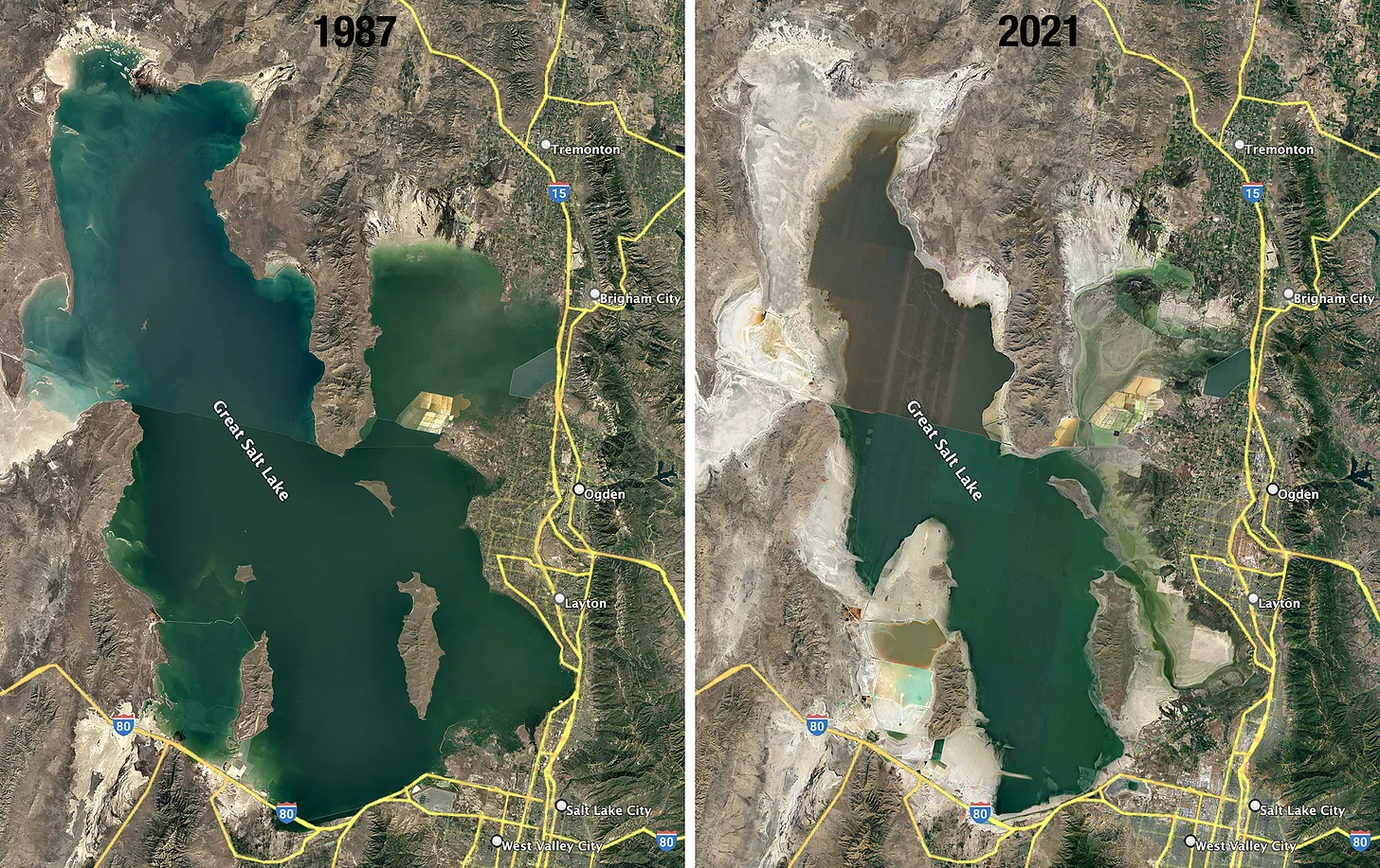
The Great Salt Lake hit a record-low elevation in 2022 and teetered on the brink of ecological collapse. It put millions of migrating birds at risk, along with multimillion-dollar lake-based industries such as brine shrimp harvesting, mineral extraction, and tourism. The lake only recovered after a few winters with above-average snowfall, but it sits dangerously close to sinking to another record-breaking low.

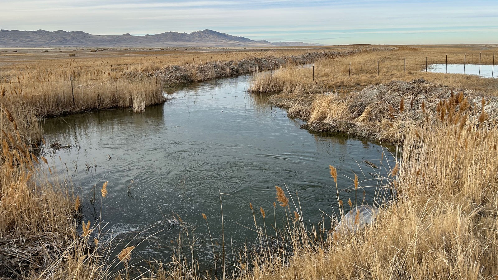
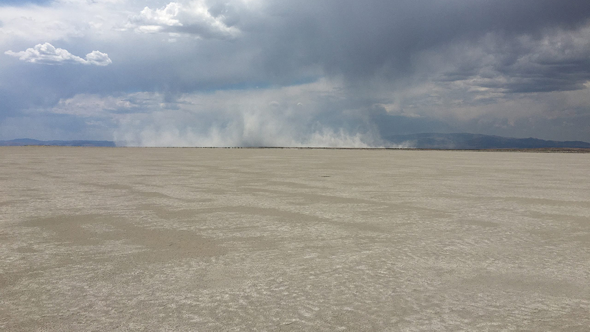
Around 800 square miles of lake bed sit exposed, baking and eroding into a massive threat to public health. Dust storms large and small have become a regular occurrence on the Wasatch Front, the urban region where most Utahns live.

The report from the Utah Physicians for a Healthy Environment and the Utah Rivers Council argues that Utah’s “baby steps” approach to address the dust fall short of what’s needed to avert a long-term public health crisis. Failing to address those concerns, they say, could saddle the state with billions of dollars in cleanup costs. “We should not wait until we have all the data before we act,” said Brian Moench, president of Utah Physicians for a Healthy Environment, in an interview. “The overall message of this report is that the health hazard so far has been under-analyzed by the scientific community.”

Click the image to download the report.

After reviewing the report, however, two scientists who regularly study the Great Salt Lake argued the nonprofits’ findings rely on assumptions and not documented evidence.

The report warns that while much of the dust discussion and new state-funded dust monitoring network focus on coarse particulates, called PM10, Utahns should also be concerned about tiny particulates 0.1 microns or smaller called “ultrafines.” The near-invisible pollutants can penetrate a person’s lungs, bloodstream, placenta, and brain.

The lake’s dust could also carry toxins like heavy metals, pesticides and PFAS, or “forever chemicals,” Moench cautioned, because of the region’s history of mining, agriculture, and manufacturing.

“Great Salt Lake dust is more toxic than other sources of Great Basin dust,” Moench said. “It’s almost certain that virtually everyone living on the Wasatch Front has contamination of all their critical organs with microscopic pollution particles.”

If the lake persists at its record-low elevation of 4,188 feet above sea level, the report found, dust mitigation could cost between $3.4 billion and $11 billion over 20 years depending on the methods used.

The nonprofits looked to Owens Lake in California to develop their estimates. Officials there used a variety of methods to control dust blowing from the dried-up lake, like planting vegetation, piping water for shallow flooding, and dumping loads of gravel.

Exposed shoreline of the Great Salt Lake in Utah (USA). The lake’s level has dropped over the past three decades, creating an enormous public health threat from windblown dust disrupting a continental migratory flyway. Photo by Brian Richter

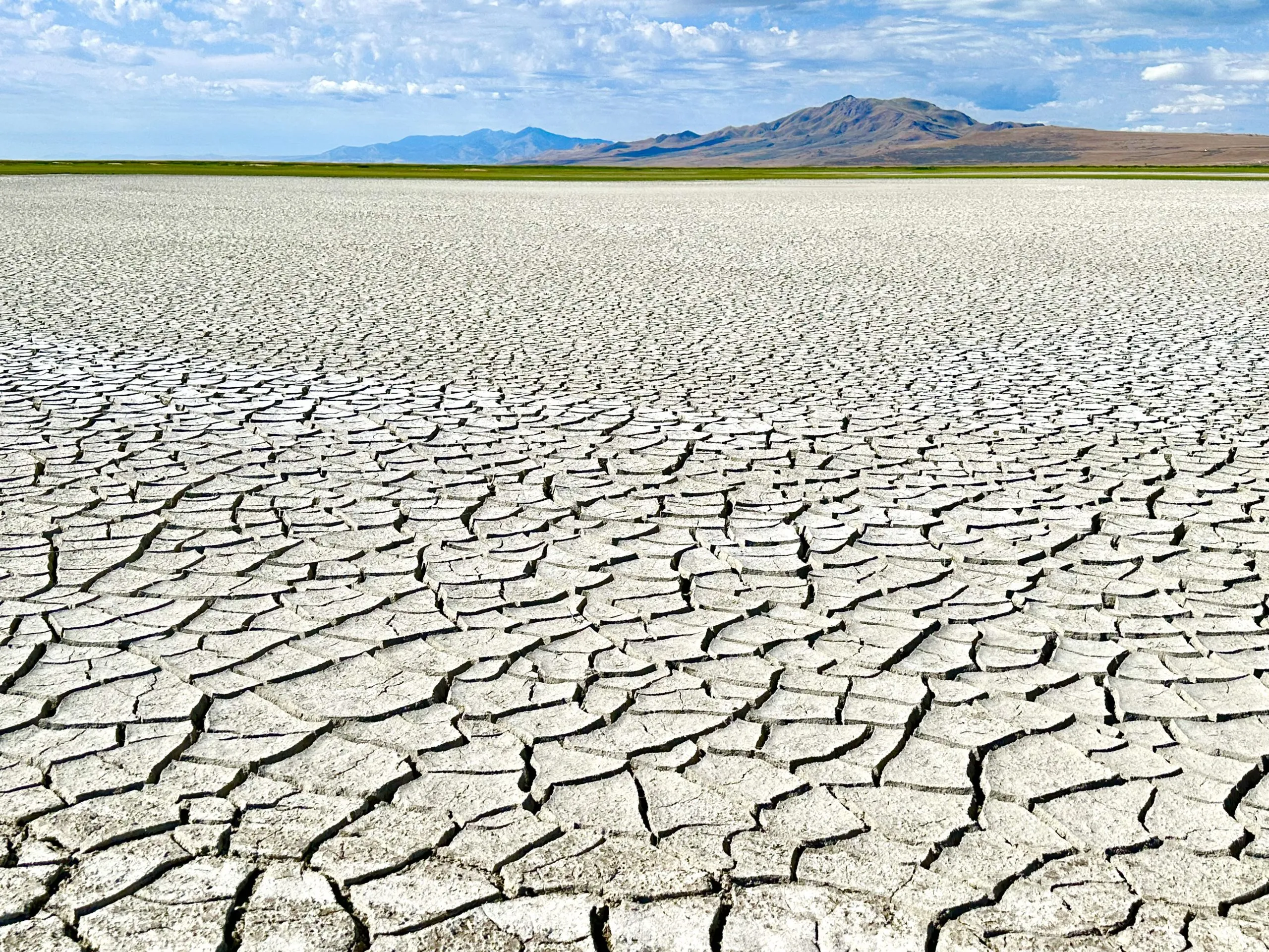
The Great Salt Lake needs to rise to 4,198 feet to reach a minimum healthy elevation, according to state resource managers. It currently sits at 4,191.3 feet in the south arm and 4,190.8 feet in the north arm.

The lake’s decline is almost entirely human-caused, as cities, farmers, and industries siphon away water from its tributary rivers. Climate change is also fueling the problem by taking a toll on Utah’s snowpack and streams. Warmer summers also accelerate the lake’s rate of evaporation.

The two nonprofits behind the report, Utah Physicians and the Utah Rivers Council, pushed back at recent solutions for cleaning up the toxic dust offered up by policymakers and researchers. Their report panned a proposal by the state’s Speaker of the House, Mike Schultz, a Republican, to build berms around dust hot spots so salty water can rebuild a protective crust. It also knocked a proposal to tap groundwater deep beneath the lake bedand use it to help keep the playa wet.

“Costly engineered stopgaps like these appear to be the foundation of the state’s short-sighted leadership on the Great Salt Lake,” the groups wrote in their report, “which could trigger a serious exodus out of Utah among wealthier households and younger populations.”

Bill Johnson, a professor of geology and geophysics at the University of Utah who led research on the aquifer below the lake, said he agreed with the report’s primary message that refilling the Great Salt Lake should be the state’s priority, rather than managing it as a long-term and expensive source of pollution.

“We don’t want this to become just about dust management, and we forget about the lake,” Johnson said. “I don’t think anybody’s proposing that at this point.”

It took decades of unsustainable water consumption for the Great Salt Lake to shrink to its current state, Johnson noted, and it will likely take decades for it to refill.

Kevin Perry, an atmospheric scientist at the University of Utah and one of the top researchers studying the Great Salt Lake’s dust, said Utah Physicians and Utah Rivers Council asked him to provide feedback on their report in the spring.

“It’s a much more balanced version of the document than what I saw last March,” he said of the report. “It’s still alarmist.”

Perry agreed with the report’s findings that many unknowns linger about what the lake bed dust contains, and what Utahns are potentially inhaling when it becomes airborne. He said he remains skeptical that ultrafine particulates are a concern with lake bed dust. Those pollutants are typically formed through high-heat combustion sources like diesel engines.

“In the report, they just threw it all at the wall and said it has to be there,” Perry said. “I kept trying to encourage them to limit their discussion to the things we have actually documented.”

The report’s chapter outlining cost estimates for dust mitigation, however, largely aligned with Perry’s own research. Fighting back dust over the long term comes with an astronomical price tag, he said, along with the risk of leaving permanent scars from gravel beds or irrigation lines on the landscape.

“Yes, we can mitigate the dust using engineered solutions,” Perry said, “but we really don’t want to go down that path if we don’t have to.”

Sunset from the western shore of Antelope Island State Park, Great Salt Lake, Utah, United States.. Sunset viewed from White Rock Bay, on the western shore of Antelope Island. Carrington Island is visible in the distance. By Ccmdav – Own work, Public Domain, https://commons.wikimedia.org/w/index.php?curid=2032320

Big Tech invades #Nevada’s power grid (and desert): Data Center Watch; President Trump Ticker; Messing with Maps — Jonathan P. Thompson (LandDesk.org)

Click the link to read the article on The Land Desk website (Jonathan P. Thompson):

September 23, 2025

🤖 Data Center Watch 👾

Last week, Jeff Brigger, an executive with NV Energy, Nevada’s largest utility — and a Berkshire Hathaway subsidiary — told a gathering in Las Vegas that tech firms are asking the utility to supply up to 22,000 megawatts of electricity to support planned data centers.

That is an insanely enormous amount of generation capacity. It’s about two-and-a-half times NV Energy’s current peak demand of 9,000 MW, according to a Las Vegas Review-Journal story. It’s enough to power about 11 million homes. And it’s equivalent to the generating capacity of five Palo Verde generating stations, the nation’s largest nuclear power plant.

Brigger noted, correctly, that these are “unprecedented times” before going on to say that the utility is “excited to serve this load.” I bet they are. Not only does it mean selling a hell of a lot more of their product, but it will also require investing in new infrastructure in a massive way, for which they can then recover the costs, with a profit, from all of their ratepayers. Warren Buffet’s about to get even richer — so long as power line-sparked wildfires don’t drain his utilities of all their cash.

To its credit, NV Energy has largely moved away from coal generation, shutting down its heavily polluting Reid Gardner plant near Moapa and replacing it with battery storage and solar. It is in the process of shutting down its North Valmy coal plant, too, but instead of tearing it down, the utility will convert it to run on natural gas, adding to its already substantial fleet of the fossil fuel-burning facilities. It’s likely that a portion of that requested 22,000 MW will come from new methane-fired plants.

But a great deal of the new capacity will also come from solar power. NV Energy is currently constructing the $4.2-billion Greenlink West transmission line between Las Vegas and Reno. And it is seeking Bureau of Land Management approval for its Greenlink North line that will run along Highway 50, also known as the Loneliest Road in America. These lines will open up hundreds of square miles of public land to utility-scale solar development, with most or all of the power going to data centers in the Reno and Las Vegas areas.

Proposed path of the Greenlink North transmission project. Credit: BLM

Look, I’d much rather see a solar or wind facility than a coal or natural gas plant. No matter how you figure it, the environmental and human health toll from burning fossil fuels is far greater than solar or wind power. A solar plant doesn’t spew sulfur dioxide and mercury and arsenic into the air (and bodies of those nearby); nor will it explode catastrophically, as a natural gas pipeline did this week in southern Wyoming, damaging a freight train and sending up flames visible from Colorado. Coal mining and natural gas extraction often occurs on public lands, damaging the ecosystem, fragmenting wildlife habitat, and polluting the water.

So it’s one thing when a new giant solar installation leads to a fossil fuel generator being retired. Yet the Big Data Center Buildup’s energy needs are so high that utilities end up deferring coal and gas plant retirements, building more gas plants, and carpeting public lands with solar. As the Center for Biological Diversity’s Patrick Donnelly put it in an email: “Turns out the destruction of the desert for renewable energy isn’t about displacing fossil fuels, it’s about feeding the big tech machine.”

Of course, at this point it’s anyone’s guess whether those solar and wind installations are ultimately built. While some are already under development in Nevada along the Greenlink West line, the Greenlink North line has yet to garner BLM approval. And since it is intended to carry primarily solar-generated electrons, it could face added scrutiny from the Trump administration. Meanwhile, Trump’s “Big Beautiful Bill” wiped out federal tax credits for solar and wind, making new developments less feasible.

It’s somewhat surprising that data centers continue to flock to the Las Vegas area given the water constraints. Nevada has butted up against the limits of its 300,000 acre-feet (down to 279,000 under current restrictions) Colorado River allotment for years. That has forced the Southern Nevada Water Authority to crack down on water consumption by banning new lawns, limiting pool sizes, and putting a moratorium on commercial and industrial evaporative cooling systems like those used by many data centers in arid regions.

As long as the moratorium stays in place — a Nevada lawmaker unsuccessfully tried to ban the ban this year — it will force new data centers in the Vegas-area to use less water-intensive, but more energy-intensive, cooling methods1. Still, the Las Vegas data centers that began operating prior to the 2023 ban use a lot of water: more than 716 million gallons, or about 2,200 acre-feet2, in 2024, according to Las Vegas Valley Water data obtained and reported by the Review-Journal.

It’s a bit overwhelming, especially since it all came on so fast. I looked back through the news and noticed that just five years ago talk about data centers’ energy and water use was confined to a few cryptocurrency miners setting up shop in rural Washington to take advantage of cheap hydropower. While the impact was big locally, it wasn’t yet throwing utilities’ long-term plans into disarray. But here we are.

Stopping the Big Data Center Buildup may not be possible. But there are ways to mitigate the impacts, and the Great Basin Water Network has some good ideas for doing so.

***

In other data center news, the Doña Ana County commissioners voted 4-1 to approve tax incentives for Project Jupiter, a proposed $165 billion data center campus in Santa Teresa in the southeastern corner of New Mexico. Once again it’s a situation in which the community and region need the economic benefits and diversity the campus offered, but which is also short on water. As such, it sparked both opposition and support.

New Mexico journalist Heath Haussamen has the most in-depth rundown in a series of stories at haussamen.com.


🤯 Trump Ticker 😱

You may wonder why a place would try to lure, welcome, or even allow data centers into their communities, given their hefty resource consumption.

Sometimes they don’t: Tucson’s city council recently rejected a proposed data center after local residents raised concerns about water and power use and a lack of transparency. (The developers re-upped their proposal for a site outside the city, but opponents aren’t backing down).

The answer, as is often the case, is for the economic shot in the arm they offer. These sprawling facilities each create hundreds of construction jobs, which offer relatively high wages (even if they are short lived). Then they need employees to operate the centers (although not nearly as many). And they pay property taxes.

Right now, Las Vegas and Nevada as a whole seem to need a little help, given that they are one of the nation’s biggest victims of Trumponomics. Visitor volume to Las Vegas was down 11% in June and 12% in July compared to the same months in 2024, with hotel occupancy rates also taking a big hit. The state has lost 600 federal government jobs since Trump took office. And it has shed a whopping 7,300 construction jobs since January. Ouch.

On a similar note, Wyoming’s mining and logging sector shed about 1,000 jobs since January, a 6% drop. That’s surprising, given that this includes coal and uranium miners and oil and gas workers, who are supposed to be the main beneficiaries of Trump’s “energy dominance” agenda. Go figure.

🗺️ Messing with Maps 🧭

Here’s one more from the USGS’s Guidebook of the western United States: Part E – The Denver & Rio Grande Western route, published in 1922. This map shows a segment of the Wasatch Front in Utah. I’ve also included a Google Earth image of the same area now. It’s remarkable to me because back then Salt Lake City was a small city that stood on its own; now it’s surrounded by a sea of sprawl. Salt Lake was a bit bigger then (or rather, the lake level was higher than it was when the Google Earth image was made; when the map was made in 1909 it was 4,203 feet, now it’s about 13 feet lower). And Bingham Canyon still was a canyon, with little towns in it, rather than the gaping hole known as the Bingham Canyon copper mine.

Joint Study Details Surface Water Movement, Measurement Need Across #GreatSaltLake Ecosystem — #Utah State University

Near the Great Salt Lake. Photo credit: Eryn Turney

Click the link to read the release on the Utah State University website (Audra Sorensen):

September 18, 2025

SALT LAKE CITY — Researchers at Utah State University just completed a joint study with the Utah Division of Water Rights to better understand surface water movement and measurement near Great Salt Lake.

The critical study comes as efforts are underway by the Great Salt Lake Watershed Enhancement Trust, Office of the Great Salt Lake Commissioner and other agencies to increase flows to benefit the lake’s diverse objectives including lake level, habitat and salinity.

By speaking with local water managers, USU researchers were able to gather key information about how surface water moves throughout the Great Salt Lake ecosystem, inclusive of Great Salt Lake’s peripheral wetlands and its water body, as well as document existing measurement infrastructure, which was previously unavailable in one location.

This study builds upon a report released by the same team in 2024 which looked at measurement gaps in the Great Salt Lake basin.

“This information was not included in the first report because we realized we needed extra time to understand the important nuances of the whole lake ecosystem connectivity,” said Eileen Lukens, a Utah Water Research Laboratory researcher on the project.

Measurement of the water flowing to the Great Salt Lake commonly relies on four gages upstream of Great Salt Lake’s peripheral wetland complexes with little measurement below those points prior to 2024, according to USU researcher Eryn Turney. This unique study involved a three-season field campaign in which the USU team visited sites at the last measurable points of inflow to Great Salt Lake.

“We realized that there was a gap in our understanding of how water moves not only to Great Salt Lake’s ecosystem as a whole, but also between distinctive portions of the ecosystem like the wetlands and water body,” Turney said. “We wanted to understand the interconnection of these areas and how increased measurement could facilitate future water delivery.”

With this in mind, USU researchers were able to identify locations where additional measurement infrastructure is needed to aid in lake-oriented objectives as well as develop diagrams to identify potential pathways for water delivery to areas of Great Salt Lake’s ecosystem.

“This study is an important step forward in understanding how water moves through the Great Salt Lake ecosystem,” said Division of Water Rights Deputy State Engineer Blake Bingham. “By identifying where additional measurement is needed, we can make better-informed decisions that support management objectives of the lake and water distribution across the basin. Collaboration like this between state agencies and our research partners strengthens our ability to administer and distribute water rights with greater confidence and transparency.”

Lukens added that their work is a part of a larger whole made up of many lake stakeholders with projects underway that contribute to tracking and managing water.

“The United States Geological Survey, Division of Water Rights and other agencies made huge efforts this past year while our study was underway to address some of the measurement gaps around the lake.” Lukens said. “Although there are still more gaps to address, we are a lot closer to understanding inflow to Great Salt Lake now.”

The full report entitled “Evaluating Surface Water Movement and Measurement near Great Salt Lake” and its associated resources have been published and made available on HydroShare.

Citation

Turney, E., E. Lukens, S. Null, B. Neilson (2025). Evaluating Surface Water Movement and Measurement near Great Salt Lake, HydroSharehttps://doi.org/10.4211/hs.4dff7b44bc574fb29beaa6ee56adbddd

Sunset from the western shore of Antelope Island State Park, Great Salt Lake, Utah, United States.. Sunset viewed from White Rock Bay, on the western shore of Antelope Island. Carrington Island is visible in the distance. By Ccmdav – Own work, Public Domain, https://commons.wikimedia.org/w/index.php?curid=2032320

#Utah Governor Cox issues drought executive order, urges Utahns to conserve water — Katie McKellar (UtahNewsDispatch.com)

Glen Canyon Dam holds back the waters of Lake Powell near Page, Arizona on Sunday, Feb. 2, 2025. Photo credit: Spenser Heaps/Utah News Dispatch

Click the link to read the article on the Utah News-Dispatch website (Katie McKellar):

April 24, 2025

With Utah facing a drier year, Gov. Spencer Cox issued an executive order declaring a state of emergency in 17 counties due to drought conditions. 

The counties covered by the order include southern and rural areas of Washington, Iron, San Juan, Kane, Juab, Emery, Grand, Beaver, Garfield, Piute, Millard, Tooele, Uintah, Carbon, Sevier, Sanpete and Wayne counties. 

West Drought Monitor map April 22, 2205.

The governor’s executive order comes after the Drought Response Committee recently recommended he act due to drought conditions. 

“We’ve been monitoring drought conditions closely, and unfortunately, our streamflow forecasts are low, particularly in southern Utah,” Cox said in a prepared statement. “I urge all Utahns to be extremely mindful of their water use and find every possible way to conserve. Water conservation is critical for Utah’s future.”

Cox’s emergency declaration also comes after he told reporters last week he was working on issuing one due to worsening drought conditions in southern Utah, which has seen a weak snowpack this winter. 

Though the governor said last week it’s been a “pretty normal year for most of the state,” there are some areas that are worse off than others. 

Currently, severe drought covers 42% of the state, and 4% is in extreme drought, according to the state’s website

This year, Utah’s snowpack peaked at 14.3 inches on March 23, which is equal to the state’s typical annual peak, according to state officials. However, southwestern Utah’s snowpack was only about 44% of normal. Plus, winter temperatures were 2 degrees Fahrenheit higher than normal. 

The state’s reservoir storage levels are at 84% of capacity, “which will help the state weather drought,” the governor’s office said in a news release. “However, drought is unpredictable, and taking proactive measures to prepare is critical.”

Cox’s order reflects the U.S. Department of Agriculture’s disaster classifications, which are informed by the U.S. Drought Monitor and NRCS’s water supply report.

“The state partners closely with federal agencies to share critical water supply and drought updates,” Joel Ferry, executive director for the Utah Department of Natural Resources, said in a  statement. “Proactive planning is essential. We ask all Utahns across all sectors to use less water to help stretch the water supply.”

It’s been almost exactly three years since the governor declared a drought declaration. The last time he did so was April 22, 2022, when 65% of the state was in extreme drought, and more than 99% of the state was experiencing at least severe drought conditions. 

As part of his order, Cox urged Utahns to watch their water use, both inside and outside their homes. 

Water-saving tips listed by SlowTheFlow.org include: 

  • Wait to water your lawn until temperatures are in the mid-70s for several consecutive days, and check the Weekly Lawn Watering Guide for other tips on how to optimize water use.
  • Fix leaks.
  • Run full loads for dishwashers and washing machines.
  • Turn off the faucet while brushing your teeth, shaving, soaping up, doing dishes or rinsing vegetables.
  • Shorten your shower time by at least one minute.
  • Participate in water-saving programs like water-smart landscaping, toilet replacement, and smart sprinkler controllers.
Utah Rivers map via Geology.com

Feds unfreeze $50M grant for #GreatSaltLake projects ahead of uncertain #runoff: Lake should get a boost again this year, conservation experts say — The Deseret News

Figure 1. A bridge where the Bear River used to flow into Great Salt Lake. Photo: EcoFlight.

Click the link to read the article on The Deseret News website (Carter Williams). Here’s an excerpt:

March 26, 2025

Water levels at the Great Salt Lake’s southern arm remain a foot below where they were this time last year as the gap between it and its northern arm shrinks. The state agency tasked with managing the massive body of water is hopeful for a good spring runoff from a “remarkably average” snowpack collection season that’s nearing an end.

“We are sitting … better than I would have expected (with) where we were a month ago,” Great Salt Lake Commissioner Brian Steed said as he provided an update on lake conditions to reporters on Tuesday. “We’ve just had … a ‘miracle’ March, and we’re happy to have that ‘miracle March’ and get water levels back up where they need to be.”

The Great Salt Lake’s southern arm is now up to 4,193.3 feet in elevation, per U.S. Geological Survey data; its northern arm is at 4,192.4 feet in elevation. While the southern arm is a foot below its level this time last year, the northern arm is up about 1½ feet because more water has flowed into it since last year. It’s expected to receive a boost from the basin’s snowpack, which is up to 18.6 inches of snow-water equivalent, about 95% of its annual median average, according to the Natural Resources Conservation Service. At least one more storm is projected later this week, while long-range outlooks also favor a wet start to April, which could elevate the basin to its third straight above-normal season.

The conservation service estimates the lake will rise another 0.5 to 1.5 feet this spring, but several variables could factor into how much…On the other hand, the lake could also receive another boost from controlled releases. Utah’s reservoir system remains 82% full — about a percentage point higher than last year and well above normal before the spring snowmelt — which means there’s less water needed from spring runoff to refill the system.

Report details the state’s ‘meaningful’ progress getting more water to the #GreatSaltLake —  Kyle Dunphey (#Utah News Dispatch) #aridification

The shores of the Great Salt Lake near Syracuse are pictured on Tuesday, May 21, 2024. (Photo by Spenser Heaps for Utah News Dispatch)

Click the link to read the article on the Utah News-Dispatch website (Kyle Dunphey):

January 15, 2025

For the last several years, Utah’s lawmakers and environmental officials have made getting water to the Great Salt Lake a priority, through policies like letting the state lease water rights from farmers, or installing new equipment to measure water flows. 

Now, a new report details the progress and impacts some of those policies are having, calling the work done so far “meaningful.” 

On Tuesday, the Great Salt Lake Strike Team issued its 2025 data and insights summary, released just in time for lawmakers to review for the upcoming General Legislative Session, which starts next week.

The Great Salt Lake hit a historic low in 2022, bottoming out at 4,188.5 feet. Lawmakers and state officials prioritized the lake that following legislative session — then the winters of 2023 and 2024 brought above-average snowfall, causing the lake levels to rebound slightly. On Wednesday, both the north and south arms hovered around 4,192 feet, still several feet below the “ecologically healthy” level of 4,198 feet. 

Formed in 2023, the Great Salt Lake Strike Team is made up of researchers from the University of Utah and Utah State University, working with officials from the Utah departments of Natural Resources, Agriculture and Food, Environmental Quality and more. 

The data-heavy 28-page report released this week outlines everything from the economic benefit of the Great Salt Lake, to locations of the dust “hotspots” on the dry lakebed that pose a health risk to the Wasatch Front, to models for future scenarios, and more.

The shores of the Great Salt Lake near Antelope Island are pictured on Tuesday, May 21, 2024. (Photo by Spenser Heaps for Utah News Dispatch)

The report also details some of the progress made in the last year that delivered more water to the lake. Consider this:

  • More than 288,000 acre-feet of water has been approved to flow to the lake, through users either leasing or donating their water right to the state. That’s enough water to fill both Jordanelle and Rockport reservoirs, although the report notes that’s just what’s been approved, and doesn’t represent the actual amount of water that’s been delivered. 
  • The Legislature is spending $1 million in one-time funds and $1 million in annual funds to install measurement infrastructure so the Utah Division of Water Rights can see exactly how much water is flowing to the lake. An additional $3 million from the U.S. Bureau of Reclamation and U.S. Geological Survey is also going toward measurement equipment. 
  • In addition to funding for water monitoring, state and federal governments have thrown nearly $100 million at the lake for various projects, including $50 million from the U.S. Bureau of Reclamation for conservation; $5.4 million from the state for wetland conservation; $22 million from the state for Great Salt Lake water infrastructure projects; $15 million from the state to the Great Salt Lake Commissioner’s Office to help lease water; and $1.5 million to start a state-funded study exploring ways to deliver more water from Utah Lake to the Great Salt Lake.
  • Compass Minerals and Morton Salt, which both operate on the lake, donated a total of 255,298 acre-feet of water to the state. Compass Minerals is also relinquishing about 65,000 acres of leased land to the state for conservation purposes. 
  • Lawmakers in 2024 passed a number of bills to help the lake, including tightened regulations and taxes on mineral extraction, allowing agricultural water users to sell leased water and restricting the use of overhead sprinklers for new government construction in the Great Salt Lake Basin. 
  • There have also been some environmental wins. Brine shrimp populations are rebounding, with a 50% increase in egg numbers compared to last year. American white pelicans returned to their nesting sites on the lake. And the state removed 15,600 acres of phragmites, an invasive plant.

The report notes that the state has made “meaningful progress.” And while it clarifies that the report is purely data-focused and doesn’t make policy recommendations, it does lay out “potential policy levers.” 

An American avocet is pictured at the Great Salt Lake near Antelope Island on Tuesday, May 21, 2024. (Photo by Spenser Heaps for Utah News Dispatch)

That includes greater incentives for water leasing. The state made several new options available for water right holders, including letting farmers lease water for a portion of the year, water banking (which gives water users more flexibility over leasing agreements) and applications allowing users to quantify water saved through optimization projects. 

But according to the report, the state hasn’t yet received any applications for these three programs. 

The Utah Legislature also recently subsidized the installation of secondary water meters, so water districts know how much they’re using — those meters are often associated with water savings. The report recommends water districts in the Great Salt Lake Basin donate or lease that saved water for the lake. 

“All indications demonstrate that delivering more water to the lake is a far more cost-effective solution than managing the impacts of a lake at a perpetually low level,” said Brian Steed, the co-chair of the strike team and Great Salt Lake Commissioner. “We can invest time and financial resources now or pay much later. Fortunately, we have great data and a balanced and workable plan to succeed.”

Sunset from the western shore of Antelope Island State Park, Great Salt Lake, Utah, United States.. Sunset viewed from White Rock Bay, on the western shore of Antelope Island. Carrington Island is visible in the distance. By Ccmdav – Own work, Public Domain, https://commons.wikimedia.org/w/index.php?curid=2032320

Saving the #GreatSaltLake by Rebalancing Its Water Budget — Brian Richter (SustainableWaters.org)

Exposed shoreline of the Great Salt Lake in Utah (USA). The lake’s level has dropped 14 feet (4.2 meters) over the past three decades, creating an enormous public health threat from windblown dust, placing global seafood production at risk, and disrupting a continental migratory flyway. Photo by Brian Richter

Click the link to read the article on the Sustainable Waters website (Brian Richter):

January 8, 2025

In recent years I’ve had the great fortune to be able to work with some amazing teams of researchers to explore the causes of water scarcity across many geographies, including the Colorado River, the Rio Grande, the Western US, and around the globe. Importantly, we’ve gone beyond just documenting the problems or threats caused by water shortages and have offered effective, proven solutions for sustainably rebalancing over-drafted water budgets. Our studies have looked at ways of conserving water in irrigated agriculture through crop shifting and other on-farm strategies as well as ways to conserve water in cities and industries.

Our just-published study of the Great Salt Lake in Utah (USA) was one of the most fascinating and enjoyable projects I’ve been involved with. I learned a great deal from our research!

I came to appreciate the hydrologic hyper-sensitivity of endorheic (lacking outflow) lakes. The Great Salt Lake is the largest saline lake in North America and the eighth largest in the world. Other big ones include the Aral Sea in Kazakhstan and Uzbekistan and Lake Urmia in Iran. All of these lakes teeter on a delicate balance between river inflows and evaporative losses from the lakes. The Great Salt Lake began to slip into long-term deficit way back in the mid-1800s when Mormon settlers from the eastern US began to capture the inflowing water from tributary rivers to expand their irrigated farms. The ensuing slow shrinkage of the lake was briefly interrupted by huge snowfalls in the 1980s and 1990s, but climate warming began to accelerate the lake’s demise since 2000. The lake dropped 14 feet (4.2 meters) and lost two-thirds of its volume during the past three decades.

The primary cause of the lake’s decline is the diversion of nearly two-thirds of the inflowing water for use in cities, industries, and irrigated farming. Farms are by far the biggest anthropogenic water consumer, accounting for 71% of water consumption, and 80% of this farm water goes to irrigated cattle-feed crops (alfalfa and grass hay). Credit: Brian Richter
Credit: Brian Richter/Sustainable Waters

The outsized contribution of irrigated cattle-feed crops to water shortages is repeated in most other river basins in the western US, and in many other water-scarce regions of our planet. As I’ve said in previous blogs, farmers and ranchers grow these crops for a simple business reason: our beef and dairy demands create a price for these crops that is quite attractive to farmers. In the past two decades, dairy consumption in the US has risen by 12%, driven mostly by increased demand for yogurt (+220%) and cheese (+28%).

In our paper, we took a close look at a variety of ways to rebalance the Great Salt Lake’s water budget by reducing production of these cattle-feed crops, along with urban and industrial water conservation. We concluded that saving the Great Salt Lake will require an overall reduction of consumptive water use by 35%; a reduction of 15% is needed to stabilize the lake to keep it from declining further, and another 20% will be needed to replenish the lake to an ecologically safe level.

Saving the Great Salt Lake will come with an eye-popping price tag: it will take at least $100 million per year for a decade to get the lake back to a safe level. However, when you put that cost in perspective, it translates to about $29 per Utah resident per year, or far less than 1% of the state’s annual budgets.

The challenges of water scarcity are growing rapidly with climate warming in many regions of the globe. Given that nearly 90% of all “blue” water (from rivers, lakes, aquifers) consumed in the world goes to irrigated agriculture, resolving water scarcity and keeping pace with climate change is going to necessarily require not just unprecedented levels of urban water conservation but also a massive transformation of what we grow on farms, and how we grow it. Because these agricultural changes commonly elicit fierce political resistance and high costs, political leaders are loathe to touch it. However, illustrative success stories are emerging around the world, demonstrating that with proper consideration of farmer needs, values, and cultures, and with financial compensation and technical support to ease difficult transitions, we can meet these challenges.

It begins by acknowledging the nature and size of the challenge, and demanding bold leadership from our decision makers. We can only run from water shortages and climate change for so long before truly disastrous consequences befall us.

Sunset from the western shore of Antelope Island State Park, Great Salt Lake, Utah, United States.. Sunset viewed from White Rock Bay, on the western shore of Antelope Island. Carrington Island is visible in the distance. By Ccmdav – Own work, Public Domain, https://commons.wikimedia.org/w/index.php?curid=2032320

Hay is sucking the Great Salt Lake dry: New study finds cattle-feed irrigation is primary culprits in water body’s shrinkage — Jonathan P. Thompson (LandDesk.org) #aridification

Click the link to read the article on the Land Desk website (Jonathan P. Thompson):

January 7, 2025

🥵 Aridification Watch 🐫

Detail from an 1852 map of the Great Salt Lake by J.W. Gunnison and Charles Preuss.

About 18,000 years ago, Lake Bonneville spread across about 20,000 square miles of what is now northwestern Utah. It was some 1,000 feet deep in places during its maximum extent, was fed by snowmelt and runoff from the mountains, and discharged into the Snake River in Idaho. Over the millennia, climate change shrunk the lake, leaving behind the Great Salt Lake and vast salt flats — shimmering plains of light and ghosts of that ancient water body.

In 1847, upon seeing the remnants of Lake Bonneville, Brigham Young declared it the “right place” for the nascent Church of Jesus Christ of Latter Day Saints to set up its base. Perhaps that was simply because he and his followers were tired of traveling, or maybe he sensed the more-than-passing resemblance to the Dead Sea in the Judeo-Christian holy lands. In any event, the new settlers eventually introduced large-scale agriculture, a rapidly growing population, and industry to the valley — all of which consumed water that would otherwise run into the lake — and eventually the Great Salt Lake began shrinking yet again. In 2022 it reached a record low level, covering just 860 square miles, compared to 2,500 back in the late 1980s.

The Great Salt Lake in 1987 and in 2021. The water dropped so low that Antelope Island ceased being an island. Source: Google Earth.

One culprit is the climate change-exacerbated mega-drought that has dragged on for over two decades. The other is the same infliction that plagues nearly every other Western water body: overconsumption. And a new, detailed accounting of consumption on the lake’s feeder streams finds that the biggest consumer is agriculture, and the crops responsible for guzzling the most water are cattle feed crops such as alfalfa and grass hay.

Though it’s not surprising, it’s always a bit of a downer to be reminded that my Chunky Monkey, green-chile cheeseburger, and yogurt habits are contributing to the depletion of not just the Colorado River, but also the Great Salt Lake.

Source: “Reducing Irrigation of Livestock Feed is Essential to Saving Great Salt Lake” by Brian Richter, et al.

The new study, “Reducing irrigation of livestock feed is essential to saving Great Salt Lake,” by Brian D. Richter, Kat F. Fowler, et al, and published in Environmental Challenges, builds upon other works, including “Emergency measures needed to rescue Great Salt Lake from ongoing collapse,” by Benjamin W. Abbot et al. The titles say it all: The largest saline lake in the Western hemisphere, which nourishes a rich ecosystem, is a major stop along the Pacific Flyway, and supports some 9,000 jobs and $2.5 billion in economic output each year, is in serious trouble.

And rescuing it, the authors say, will “require a massive transformation of agricultural production in the basin, particularly in cattle-feed production. Failure to implement the agricultural adjustments needed to arrest the decades-long decline of the lake will lead to serious and escalating threats to regional-scale public health, a continental-scale migratory flyway, and global-scale shocks in seafood production.”

The new study’s findings include:

  • “The lake’s shrinkage is attributable to anthropogenic consumption of 62% of river water that would have otherwise reached and replenished the lake.”
  • The Great Salt Lake reached its highest level in more than a century in 1987, following a series of extremely wet winters, but has been dropping by about four inches per year on average since then. From 1989 to 2022, the lake lost 10.2 million acre-feet and the surface level dropped 14 feet.
  • Lake shrinkage is bad for human health because it mobilizes dust containing toxic heavy metals such as arsenic, copper, lead, zinc, cadmium, mercury and other metals, many of them from mining runoff.
  • Great Salt Lake is the world’s largest supplier of brine shrimp eggs, a key food source for the aquaculture industry. As the lake shrinks, salinity increases, stressing the brine shrimp and lower production.
  • The lake is a crucial nexus within Pacific Flyway, and the birds eat brine shrimp and brine flies. Wilson’s Phalaropes and Eared Grebes are threatened by the decline of GSL, and they could be listed under the Endangered Species Act, which could impact industry around the lake.
  • Aggregate water consumption from both anthropogenic and environmental (riparian evapotranspiration and lake evaporation) sources exceeded lake inputs from river inflows and direct precipitation by 309,664 acre-feet per year on average from 1989-2022.
  • Irrigated farms now cover 791 square miles within the basin, with 70% of the acreage dedicated to growing cattle feed crops. There’s also public land grazing leases, which cover more than half of the 21,000-square-mile Great Salt Lake basin and provide additional forage for about 10% of all cattle in the basin.
  • The 2022 U.S. Agricultural Census counted nearly 1 million cattle within the basin; about 70% were beef and 30% dairy.
  • Alfalfa farms within GSL basin produce an average of 3.7 tons per acre, for a total of 951,889 tons per year, or a little over half of all the alfalfa grown in Utah.
  • Alfalfa water use per year is estimated at 617,034 acre-feet and other hay use 291,695 acre-feet, for a grand total of more than 900,000 acre-feet (or about 57% of all anthropogenic uses in the basin).
  • About 38% of the cattle feed grown in the basin stays in the basin, with about 25% exported to the Snake River basin in Idaho, and 13% going to California, the nation’s leading milk producer. An estimated 17% is exported internationally, primarily to China and the Middle East.
  • Cattle feed crops in the basin produced an estimated $162 million in cash receipts in 2021, or about .07% of Utah’s GDP. But alfalfa prices jumped about 85% between 2000 and 2021, mainly driven by rising demand from dairy as Americans eat more yogurt and cheese. That makes alfalfa a more lucrative crop for its growers, and ceasing production would have an outsized local impact.

Currently the lake is suffering from an annual water deficit of about 310,000 acre-feet. But researchers believe the strains of climate change will keep driving the deficit higher, and point to the need to bring the lake back up from its diminished levels. Some are pushing for up to 1 million acre-feet in consumption cuts per year, but Richter and company are suggesting a more politically palatable 650,000 acre-feet per year. Still, that’s a boatload of water.

So how to get there? Once again the obvious solution — stop growing alfalfa — is also the most contentious, and far more complicated than it appears. The economic impact would be devastating locally, and would also change the communities’ cultures. Farmers tend to hold the most senior water rights, meaning they legally can continue to use that whatever however they please. And paying farmers to fallow that much land would not only be prohibitively expensive, but also would create other problems, such as dust and noxious weed proliferation.

The authors present a range of less drastic, but still ambitious — and painful — options, including:

  • They found they could reduce crop water consumption by 91,500 acre-feet per year by replacing alfalfa with winter wheat. Split-season irrigation, or reducing the number of cuttings from three to one, could save another 477,130 acre-feet (but would reduce alfalfa and hay production by 61%).
  • Combining split-season irrigation and partial fallowing could achieve the 650,000 acre-feet target, but it would cost $76 million per year for foregone alfalfa production plus $21 million for reduced grass hay production.
  • If the municipal and industrial and mineral extraction sectors cut consumption by 20%, it could reduce the deficit by about 110,000 acre-feet, leaving agriculture to pick up the remaining 550,000 acre-feet through the above strategies.
  • Temporary leasing of agricultural water rights would cost as much as $423 million annually, but would give farmers more flexibility over what they do with the land (and it would only be temporary).

“Ultimately the debate about whether to save the GSL will be about cultural issues, not economics or food security,” the authors conclude. “The potential solutions outlined here implicate lifestyle changes for as many as 20,000 farmers and ranchers in the basin. In this respect the GSL serves as a microcosm of the socio-cultural changes facing many river basin communities in the increasingly water-scarce wester U.S. and around the globe.”

Think like a watershed: Interdisciplinary thinkers look to tackle dust-on-snow

Jonathan P. Thompson

November 5, 2024

🥵 Aridification Watch 🐫

Read full story

Momentum Gaining on Important Water Work to Benefit Birds and People in the West — Audubon #BirdsNeedWater

American White Pelican. Photo: Elizabeth Yicheng Shen/Audubon Photography Awards

Click the link to read the article on the Audubon website (Karyn Stockdale):

December 22, 2023

**Este artículo se puede encontrar en español**

This year was marked by incredible progress in terms of Audubon’s priorities for water conservation in the West, and yet, we have so much more to do for the birds and people who rely on clean and reliable water. In my lifetime, North America has lost more than 3 billion birds—a catastrophe reaching a tipping point. If we act now, we can reverse this trend and protect people and birds in the arid West. And while daunting, we are making an impact.

Sometimes we hesitate to celebrate or call an achievement a “win” because the work is so massive and ongoing, with climate change and drought still present, and the threats facing the rivers, lakes, and wetlands—and the essential habitats they provide to birds—are growing. Adding more water into the Colorado River, Rio Grande or Great Salt Lake can feel tiny compared to what they need, or what they once were, or could be. But we are seeing birds respond. These victories add up and show decision-makers that new solutions can work, especially when scaled up. Thanks to our supporters and partners, we’ve directed and secured more conservation funding from federal and state governments to these iconic watersheds, we’ve changed public policies and water management where it was outdated and no longer serving today’s needs, and we continue to push for better outcomes for precious water resources in the West.

Much of the work we do is often behind the scenes because of complex technical and legal requirements (such as water transactions to benefit Great Salt Lake or modeling to determine optimal timing for bird surveys). Because of this, it can be challenging to capture the impact we’re making. On top of that, this work can be politically messy—even while we maintain great relationships with many legislators, government officials, and partners.

Despite the challenges, the momentum continues to build in our work around the West and in Washington, D.C.

In 2023 alone, we:

The range of Audubon’s work is vast: from implementing innovation and market-based solutions, to mobilizing science partners that address knowledge gaps for priority birds, and to thought leadership in water policies and management decisions. Here’s a high-level view of that work:

Great Salt Lake Watershed Enhancement Trust in its first year   

At Great Salt Lake, Audubon, along with The Nature Conservancy, has been co-leading the Great Salt Lake Watershed Enhancement Trust (aka the Trust)—a key effort among many solutions needed in protecting and enhancing the water quantity and water quality for the lake and its wetlands. These are some of the most critical habitats for birds in North America. The Trust, working with the State of Utah’s Divisions of Forestry, Fire and State Lands and Wildlife Resources, have facilitated, provided transaction costs, and contributed funding to water transactions for more than 50,000 acre-feet of water for Great Salt Lake. The bulk of this water was donated or partially donated, including what is believed to be the largest-ever permanent water donation of water to Great Salt Lakefrom the Church of Jesus Christ of Latter-day Saints.

The wetlands surrounding Great Salt Lake provide crucial habitat for millions of migratory birds, recreational opportunities, and many other public benefits including protecting water quality. 

The Trust also awarded $8.5 million in grants for the restoration and protection of approximately 13,000 acres of wetlands surrounding the Great Salt Lake ecosystem to benefit the lake’s hydrology, with the projects bringing more than $6.5 million in matching contributions.

This year is just the beginning, as we’ll secure more water for Great Salt Lake in 2024 and beyond. In the face of climate change, unpredictable drought, and increasing water demands, the Trust, and many other interested parties will need to work collaboratively to bring more water to the lake.

Intermountain West Shorebird Surveys after a 30-year hiatus 

Understanding how migrating shorebirds are responding to habitat changes as saline lakes face the threat of desiccation due to climate change and water diversions has been an essential driver for our work with partners in the regional Intermountain West Shorebird Surveys. Now with three seasons under our belt (Fall 2022, Spring 2023, and Fall 2023), Audubon and Point Blue Conservation Science aim to fill data gaps for at least 30 species of shorebirds and their vulnerable habitats in an area bounded on the West by the Sierra Nevada Mountains and on the East by the Rocky Mountains. Conditions have dramatically changed since the last major effort like this was undertaken over 30 years ago, and the need for updated information is more important than ever. We teamed up with the U.S. Fish and Wildlife Service, several Tribes, 11 state wildlife agencies, 35 Audubon chapters, hundreds of volunteers, private landowners, and many other non-profit organizations to count shorebirds in their peak migration windows at 200 sites across the West—and we will do so through 2025—to inform shorebird conservation.

In the time since we’ve kicked off this enormous survey effort, extremes of “weather whiplash” have made for interesting results. For instance, August 2022 was the peak of this mega-drought; Spring 2023 had record-breaking runoff; August 2023 had the West Coast’s Tropical Storm Hilary. We’ve also seen surprising statistics so far, including a record-breaking maximum count of shorebirds at the Salton Sea. The previous max count was 105,000 and the most recent survey counted over 250,000 shorebirds.

We aim to fill more data gaps, but more resources and collaborations are needed to ensure a robust understanding of these species needs. From American Avocet to Wilson’s Phalarope to Snowy Plovers, many species that rely on saline lakes throughout their lifecycle are benefitting from capable partnerships like this, increasing our shared knowledge and allowing for more focused management and protection of their unique habitat needs. 

Colorado River “Beginnings”. Photo: Brent Gardner-Smith/Aspen Journalism

Colorado River at a pivotal moment to reduce water use while including the needs of birds

The lifeblood of the American West received a lifeline this year with an above average winter—but the decades-long overuse problems remain. We know that it may take a decade or more of above average winters to restore the main Colorado River reservoirs to pre-2000 levels. The overall trend is that the available water in the Colorado River is declining, even while the United States and Mexico, Tribes, state governments, cities within the basin, and farmers are doing more than ever to ensure available water supply for subsequent years.

We know that to save the Colorado River, we need to use less water. And as the U.S. Bureau of Reclamation continues long-term and short-term planning on the Colorado River, it’s important to remember that while the Colorado River is unpredictable, planning for that future can help all of us in the long run. These plans need to also consider the enormous third-party impacts of reducing water uses in the Colorado River. Thank you to the Audubon network members who sent more than 31,000 comments to the Bureau of Reclamation in 2023 in favor of better outcomes for people, birds, and the environment.

Western yellow-billed cuckoo at Montezuma Well, Arizona. Photo Courtesy of Gary Botello via the National Park Service

Wrapping up 2023 and looking ahead to next year

We remind ourselves that birds are not only essential components to a healthy ecosystem, birds are daily reminders of our interconnections. This year, a tagged Western Yellow-billed Cuckoo, a federally threatened bird, taught us a little bit of humility and awe when it passed through at least six protected areas on its international journey south. For these riparian-dependent birds, overuse and over-allocation of water in a drought and climate stressed region has led to a precipitous decline in their population. This one migrating bird had the power to remind us that the water work we’ve prioritized and progress we are making matters.

As we move in to 2024, Audubon will continue to advocate for a more secure future for water in the West. Our livelihoods, our environment, and the well-being of future generations require that we continue this hard work now in hopes of preventing catastrophes later. And for migrating birds, keeping the water needed for the network of conserved, restored, and undeveloped habitat across the Southwest adds up today and towards long-lasting solutions. While the work is important, vast, and sometimes uncertain, we remain dedicated and even hopeful that our work and the work of our partners will result in better outcomes for people and birds.

Created by Imgur user Fejetlenfej , a geographer and GIS analyst with a ‘lifelong passion for beautiful maps,’ it highlights the massive expanse of river basins across the country – in particular, those which feed the Mississippi River, in pink.