Arizona: Three Exciting Desal Concepts

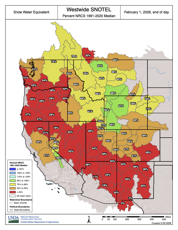
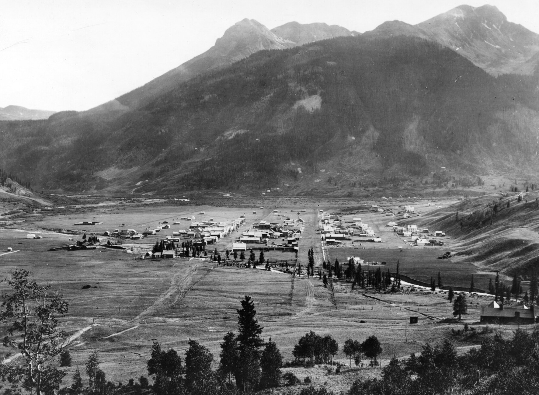
by Robert Marcos, photojournalist, Grand Junction Colorado

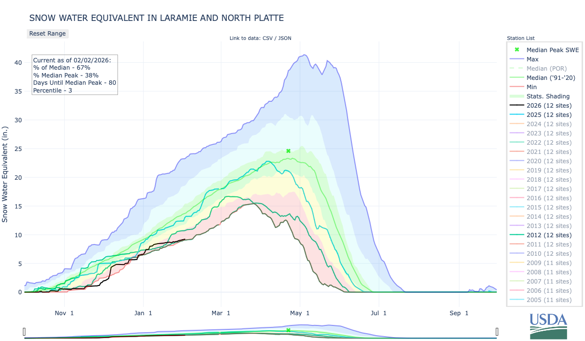
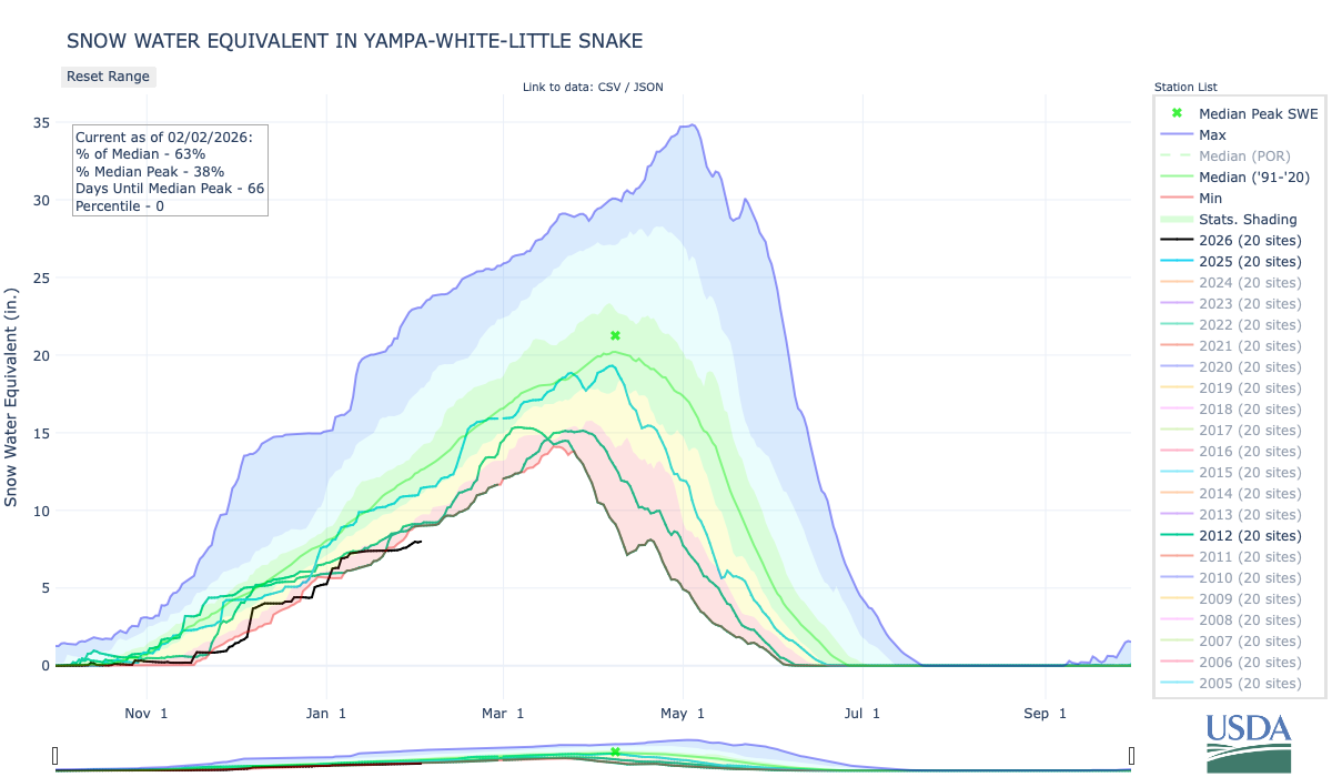
The Arizona Water Infrastructure Finance Authority (WIFA) has welcomed proposals from project teams on diverse strategies like ocean desalination, surface water importation, wastewater reclamation, and novel technologies to develop new renewable sources that bolster the state’s long-term water security amid growing shortages. The effort by WIFA come as the state faces additional cutbacks in its Colorado River supplies and its existing sources of groundwater are stressed to the limit.1

Concept 1: Reactivating the Yuma Desalting Plant

Persistent Colorado River shortages since the 2000s have prompted Arizona stakeholders, including the Central Arizona Project (CAP) and ADWR, to evaluate the Yuma Desalting Plant operation as a supply augmentation tool. Legislative proposals like Sen. Martha McSally’s 2020 bill sought to mandate repairs and restart, though dismissed as unfeasible due to $160-450 million in upgrades plus $25-40 million annual operations.2

As of 2025, the plant remains in “ready reserve” with ongoing evaluations of tech upgrades and alternatives like well-field pumping to protect the Ciénega de Santa Clara wetland in Mexico, which relies on untreated drainage flows. Environmental groups oppose reactivation, citing $670+ million costs for partial operation and habitat risks, while Bureau officials prioritize conservation over YDP use.3

Concept 2: Building a New Desal plant in Puerto Penasco

Arizona has shifted away from the original IDE Technologies proposal for a Sea of Cortez desalination plant near Puerto Peñasco, Sonora, which faced transparency issues and was not exclusively pursued. Instead, the Water Infrastructure Finance Authority advanced four alternative proposals in November 2025 for further feasibility analysis.4

One of those alternative proposals has a water exchange as a core mechanism: desalinated water output supplies Mexican users (e.g., local communities or agriculture), which would free an equivalent volume of Mexico’s Colorado River allocation for Arizona diversion northward via the Central Arizona Project canal to Phoenix and Tucson. This aligns with broader WIFA-approved initiatives from partners like EPCOR and Acciona-Fengate, which propose similar Gulf of California or Baja plants producing 150,000–500,000 acre-feet by 2031–2034 in “equal-for-equal” swaps, avoiding long-distance Arizona pipelines. Challenges include high costs ($3,000+ per acre-foot), U.S.-Mexico approvals, environmental compliance for brine discharge, and contract risks in surplus years, but it leverages proven global tech to onshore supplies without Upper Basin conflicts.5

Concept 3: Investing in a new desal plant in Southern California

Arizona has explored offering to invest state funds, through its water financing authority, in a large new seawater desalination plant on or near the Southern California coast, with the core idea that Arizona would help underwrite construction and then receive a contractual share of the plant’s output. In turn, that desalinated water would be used within California to free up an equivalent portion of California’s Colorado River allocation, which Arizona would then take upstream via the Colorado River and Central Arizona Project canal, effectively turning ocean water into an additional Colorado River supply for Arizona through an interstate exchange mechanism.6

Putting land into the public’s hands: And other bits and pieces — Jonathan P. Thompson (LandDesk.org)

Fields, trees, and the Abajos. North of Dove Creek, Abajo Mountains in the distance. Photo credit: Jonathan P. Thompson/The Land Desk

Click the link to read the article on The Land Desk website (Jonathan P. Thompson):

January 30, 2026

Updated to get the graphics right.

🌵 Public Lands 🌲

If you’ve ever floated the Gunnison River in western Colorado through the Dominguez-Escalante National Conservation Area between Delta and Grand Junction, you’ve probably noticed that the land on either side of the stream alternates between public parcels and private ranch land. If the Bureau of Land Management has its way, some 4,000 acres of that private land will soon be entering the public domain, according to reporting from the Grand Junction Daily Sentinel. That’s right, the agency is putting more lovely land into the public’s hands. 

The parcels were formerly operated as a ranch by Dick Miller. After he died, the Conservation Fund purchased the land from Miller’s son for an undisclosed amount in order to sell it to the BLM. The associated BLM grazing leases will reportedly be transferred back to the BLM, but it isn’t clear whether they’ll be made available for grazing again.


The BLM is also looking to put a lot of public land into oil and gas companies’ hands. The agency is seeking public input on proposals to lease 74 parcels covering 33,530 acres in New Mexico, and 271 oil and gas parcels totaling 357,358 acres in Wyoming

The New Mexico parcels are mostly in the Permian Basin, but do include tracts in the San Juan Basin located north and northeast of Chaco Culture National Historical Park (but not within the ten-mile buffer zone, which remains in place — for now). 

The Wyoming parcels are concentrated in the southern part of the state between Rawlins and Green River, the central part of the state, and the Powder River Basin.

🦫 Wildlife Watch 🦅

Wolves in the West have had a rough go of it ever since white settlers showed up in the 1800s and proceeded to slaughter them en masse. And while they’ve been able to recover somewhat in the Northern Rockies, thanks in part to endangered species protections and reintroduction efforts, the move to bring them back to Colorado and the Southwest has hit obstacles — and tragedy, including:

  • Another reintroduced wolf has died in Colorado, reports the Colorado Sun’s Tracy Ross, bringing the total number of wolf fatalities since the start of reintroduction to 11. The cause of death has not been determined.
  • Meanwhile, Colorado Parks and Wildlife has paused new wolf reintroductions because it hasn’t been able to find another state or tribal nation to provide the animals.
  • Utah Department of Agriculture officials killed three wolves in the northern part of the state on Jan. 9. While wolves are protected by the Endangered Species Act in most of the state, they were delisted in one small section along the Wyoming border when protections were lifted for the Northern Rockies population. Now, apparently, the state will kill any wolves that wander into that area, just because they can, and to prevent them from going into the protected zone. That’s despite the fact that the three animals had not killed or stalked any livestock. “I have not heard any of my neighbors, and we haven’t had the experience ourselves that we’ve had actual issues with our cattle and wolves,” area livestock owner Launie Evans told KSL.
  • And in more sad news: “Taylor,” the Mexican gray wolf that wandered out of southern New Mexico and into the Mt. Taylor region, was found dead on I-40 near Grants. Taylor first roamed onto Mt. Taylor early last year, apparently not realizing that the feds don’t allow wolves to cross I-40. Wildlife officials captured him and deported him back to the southland, but he was persistent, and simply turned around and headed north again. He was removed again in November, but couldn’t stay away from Mt. Taylor. This time, on his return journey, he was struck by a vehicle.

    “Taylor’s death is a heartbreaking reminder that highways like I-40 are not just lines on a map, they are lethal barriers for wildlife,” said Claire Musser, executive director of the Grand Canyon Wolf Recovery Project, in a statement. “Abolishing I-40 as a management boundary is long overdue. If we are serious about recovery, we must allow wolves to move freely across suitable habitats and invest in wildlife crossings and landscape-scale connectivity so highways no longer function as death traps.”
  • And, finally, CPW’s latest map of wolf activity is out (at the top of this section), and it shows that wolves have been wandering into new parts of the state. Folks in the Silverton area might just be seeing some soon. If you think you see one, but aren’t sure if it’s a wolf or coyote, this little guide from CPW might help:


Longread: On wolves, wildness, and hope in trying times: How Ol Big Foot’s story restored a shard of optimism — Jonathan P. Thompson


⛏️ Mining Monitor ⛏️

Public Citizen just released an accounting of some of the ways the Trump administration is subsidizing global mining corporations and their operations on public lands — and the ways in which executives made off like bandits as a result. It’s worth reading the whole report, but here are just a small sampling of highlights:

  • $8.8 million: Amount 13 mining corporations, including Rio Tinto, Resolution Copper, South32, Lithium Americas, and Ambler Metals, spent on lobbying in 2025.
  • $3.5 million: Amount Lithium America paid Interior Department official Karen Budd-Falen’s husband for water rights for its Thacker Pass mine in Nevada. The federal government also took a 5% stake in the company and the mine as a condition of preserving a Biden-era loan.
  • $400 million: Amount the U.S. Defense Department paid for a stake in Las Vegas-based MP Materials, which owns the Mountain Pass rare earths mine in California. The Pentagon also loaned the company $150 million.

The Bureau of Land Management approved the Grassy Mountain gold and silver mine on 469 acres of public land in Malheur County, Oregon. The action allows Paramount Gold Nevada to develop an underground mine, an onsite mill, and “associated storage” (which I’m taking to mean they’ll be able to dispose of toxic mill tailings on public land mining claims).

📖 Reading (and watching) Room 🧐

Here’s a great piece by Leah Sottile, who has written authoritatively on right-wing movements and more, on the plague of hypocrisy going around right now.


The Truth Does Not Change According to Our Ability to Stomach It: 67. Hypocrisy On the whiplash of this chaotic moment — Leah Sottile


The Border Chronicle is indispensable reading these days and, well, always. This piece, titled Border Patrol Nation, is an important look at the violent history of the Border Patrol.

*

And you really should be reading Wayne Hare’s writing over at the Civil Conversations Project.


📸 Parting Shot 🎞️

Speaking of hypocrisy: I’m sure most of you have heard Trump administration officials saying that federal ICE and/or CPB agents shot Alex Pretti because he brought a gun to a protest. The photos below were all captured at the May 2014 Recapture rally in Blanding, Utah. Quite a few of the attendees — who were on hand to protest “federal overreach” — were armed. None of them were shot. Just sayin’.

Folks exercising the right to bear arms at Recapture Canyon to protest federal overreach. Photo credit: Jonathan P. Thompson

Musical Sendoff

Broken treaties with the Utes paved the way for #Colorado’s 1870s San Juan silver rush: Thousands flocked to boomtowns like #Ouray and #Silverton as Colorado neared statehood — Chase Woodruff (ColoradoNewsline.com)

Silverton, Colorado is pictured in this William Henry Jackson photograph dated between 1876 and 1880. (Courtesy of Denver Public Library Digital Collections, X-1717)

Click the link to read the article on the Colorado Newsline website (Chase Woodruff):

January 30, 2026

In the years leading up to Colorado statehood, nearly all of the territory’s western half still belonged to the Ute people, who had inhabited the northern Colorado Plateau for centuries.

An 1868 treaty between the U.S. government and six bands of the Ute tribe reserved nearly all of the western half of the Colorado Territory for their “absolute and undisturbed use and occupation,” and stated that “no persons … shall ever be permitted to pass over, settle upon, or reside in the territory described.”

The agreement lasted just four years.

Ouray and subchiefs, 1873. Ute Indians and agents in Washington, DC after conclusion of the 1873 Brunot Agreement. Front row, left to right: Guero, Chipeta, Ouray, and Piah; second row: Uriah M. Curtis, James B. Thompson, Charles Adams, and Otto Mears; back row: Washington, Susan (Ouray’s sister), Johnson, Jack, and John. Photo credit: Colorado Encyclopedia

By 1872 prospectors for gold and silver in the San Juan Mountains were routinely trespassing on Ute lands, and the following year the federal government — under pressure from territorial leaders demanding access to the region’s “large bodies of mineral and agricultural resources” — pushed the Utes to cede a 3.7-million-acre area surrounding the San Juans in what was known as the Brunot Agreement.

So began the Colorado Territory’s next major mining boom, and the first to be concerned principally with silver — the extraction and minting of which would dominate the soon-to-be state’s economy and politics for the next several decades.

By 1876, fortune seekers could reach the San Juans by taking the Denver and Rio Grande Railroad to Cañon City, and from there traveling on grueling mountain toll roads to mining settlements like Ouray, Silverton and Lake City. In late January 1876, the Silver World of Lake City advised that despite “the unusual quantity of snow,” the wagon road that passed through Saguache was manageable with sleighs, but the more southerly route through Del Norte was “almost impassable.”

(Courtesy of the Colorado Historic Newspapers Collection, Colorado State Library)

The silver rush had helped revive the fortunes of southern Colorado, turning towns like Pueblo and Cañon City, where residents had long felt ignored by the territory’s northern establishment, into important transportation and commercial hubs serving the remote San Juan mining district.

Other Front Range towns, including Colorado Springs, regretted “the outflow of men consequent upon the San Juan and other mining excitements.” A gold rush to the Black Hills of the Dakota Territory was also underway at the time — another treaty-breaking incursion into Native American lands, which would soon lead to a war with the Lakota people and the Battle of Little Bighorn later in 1876.

The San Juan mines, wrote the Silver World, required “earnest, energetic men … who can submit to the deprivation of the luxuries of a higher civilization.” The paper’s weekly editions from the winter of 1876 contained few reports of serious crime, though the threat of “snowslides,” frostbite and mountain lions were often mentioned.

But by then the region’s boomtowns were beginning to evolve from rough-and-ready mining camps into something more established — incorporating municipal governments, forming school districts and issuing bonds for the construction of new wagon roads and other public improvements. Ordinances approved by Lake City’s new board of trustees included a schedule of fines levied for misdemeanors, published in the Silver World on Jan. 15.

“Read the ordinances which appear in this issue,” the paper’s editors advised, “and save yourself the possibility of being fined or getting in the ‘jug.’”

Public intoxication or animal cruelty could cost an offender up to $50, while the penalty for impersonating a police officer or “immoderately” riding or driving horses on town streets could run up to $100. To “quarrel in a boisterous manner” was considered a breach of the peace and carried a fine of between $5 and $25.

Arriving in Denver for the meeting of the territorial Legislature in January, Rep. Reuben J. McNutt of Silverton had brought a petition from his fellow settlers for the creation of a new county encompassing the western San Juan boomtowns. The Legislature soon passed House Bill No. 1, and Gov. John Routt signed it into law on Jan. 31, officially creating the new San Juan County, from which the present-day counties of Ouray, San Miguel and Dolores would later be carved out.

Alongside these administrative necessities, some inhabitants of the remote mining towns aimed for the cultural betterment of settlements like Lake City, where the Silver World reported billiards were still the “principal amusement.” The Lake City Dramatic Club staged its first theater production on Feb. 2, 1876, performing George Melville Baker’s “Among the Breakers,” and the cast of amateurs won a rave review from the local paper.

“The universal testimony of all who witnessed it was that it would have been difficult for professionals to have surpassed it,” declared the Silver World. “The play was in all respect (was) well mounted and in no instance were there any of those hitches so common in entertainments of this nature, and which tend alike to embarrass the performers and distract the attention of the audience.”

The gradual dispossession of Ute lands in western Colorado would not end with the Brunot Agreement and the rush to the San Juans. The so-called northern or White River Utes were expelled from Colorado beginning in 1880, and today reside on the Uinta and Ouray Indian Reservation in Utah. Three other bands of the tribe grouped together as the southern Utes — the Capote, Mouache, and Weenuche — agreed in 1878 to cede all but a small portion of their lands in far southwest Colorado along the New Mexico border.

The southern Utes later split into the Southern Ute Indian Tribe, consisting of the Capote and Mouache bands, and Ute Mountain Ute Tribe, made up of the Weenuche band. Today, the Southern Ute and the Ute Mountain Ute are the only two federally-recognized tribes within Colorado’s borders.

Federal land and Indian reservations in Colorado

#Utah Governor Spencer Cox vows to fill Great Salt Lake by 2034 — News 4 Utah

Sunset from the western shore of Antelope Island State Park, Great Salt Lake, Utah, United States.. Sunset viewed from White Rock Bay, on the western shore of Antelope Island. Carrington Island is visible in the distance. By Ccmdav – Own work, Public Domain, https://commons.wikimedia.org/w/index.php?curid=2032320

Click the link to read the article on the News 4 Utah website:

January 27, 2026

Utah Gov. Spencer Cox has proposed a plan to fill the Great Salt Lake by 2034, aiming to restore the lake that currently supports approximately 7,000 jobs…

Brian Steed, the Great Salt Lake Commissioner, highlighted efforts to conserve water among local residents and the agricultural community. “I think we have a lot of work to do to get there obviously we all work for the governor and I’m really happy to set that as our metric and we’re going to strive really hard to make that goal,” said Steed. He noted that the goal is not just about filling the lake but also about encouraging sustainable water use practices in the surrounding communities.

Steed indicated that strategic plans have been in place for years to identify areas where water can be shared with the Great Salt Lake. This includes working with local agriculture to promote efficient water usage that benefits both farmers and lake levels.

Utah Rivers map via Geology.com