The controversy surrounding Glen Canyon Dam’s River Outlet Works (ROW) centers on a critical design vulnerability: the dam may soon be unable to reliably release water if Lake Powell drops below the minimum power pool (3,490 feet). 1
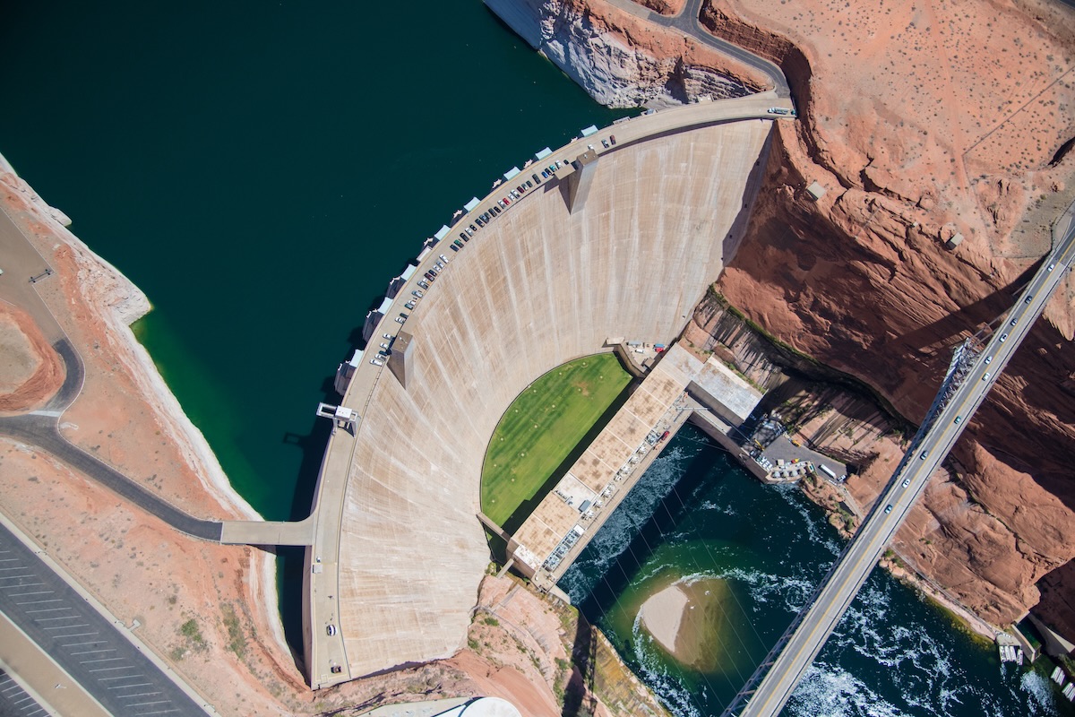
Aerial photo of the Glen Canyon Dam near Page, Arizona. Photo by Alexander Heilner/The Water Desk, with aerial support by LightHawk.
While the dam usually releases water through high-elevation penstocks to generate hydropower, the ROW—four 8-foot-wide steel pipes—is theonly way to move water once levels drop too low for the turbines. Recent inspections by the Bureau of Reclamation revealed significant damage to these pipes, including cavitation—a process where high-velocity water creates vapor bubbles that implode, eroding the steel.2
Reliability Gap: The ROW was designed for temporary use (e.g., flood control), not for the continuous, long-term operation that a “dead pool” scenario would require. A March 2024 memo from the Bureau of Reclamation warned that they should not be relied upon as the sole means of sustained water delivery.3
Legal & Economic Threat: If the ROW fails or its capacity is restricted to prevent further damage, the Upper Basin states may be unable to meet their legal obligation to deliver water to 30 million people in the Lower Basin (Arizona, Nevada, California).4
Safety Buffer: Due to the damage, the Bureau recently determined they can only safely operate the ROW at levels at least 24 feet above dead pool (3,370 feet), effectively raising the “failure point” of the dam’s plumbing.5
Proposed Fixes: Environmental groups, such as the Utah Rivers Council, advocate for drilling new, lower-level bypass tunnels around the dam to ensure water can flow even at riverbed levels. However, these modifications are costly and could take over a decade to implement.6
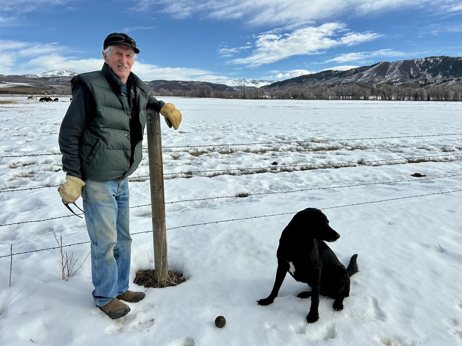
Meadows in north Routt County, Colorado, were bare in spots on Feb. 9 after a slow start to this winter’s snowpack. Scott Franz/KUNC
Click the link to read the article on the KUNC website (Scott Franz):
February 13, 2026
This story is part of ongoing coverage of the Colorado River, produced by KUNC in Colorado and supported by the Walton Family Foundation. KUNC is solely responsible for its editorial coverage.
Jay Fetcher and other ranchers in northwest Colorado measure snowpack each winter using their barbed wire stock fences.
A healthy level is called a three wire winter, when the snow piles up past the third wire above the ground. But on Feb. 9, the region was experiencing a zero wire winter.
“We just have no snow, and I have never seen it, in my 75 years here, I have never seen this,” Fetcher said Monday as he navigated patches of mud on his ranch in the Elk River valley north of Steamboat Springs.
Jay Fetcher poses on his ranch in northwest Colorado on Feb. 9. Low snowpack is adding pressure to negotiations on how to conserve the dwindling Colorado River. Scott Franz/KUNC
Many of the hills and meadows surrounding his ranch were brown and bare. The thermostat on Fetcher’s truck read 50 degrees, and the last patch of snow was melting fast off the roof of a barn.
This year, Fetcher’s ranch is on the frontlines of record-low snowpack across the West that is adding a sense of urgency among seven states to finalize a plan for how to conserve the dwindling Colorado River.
The snow in the nearby Zirkel wilderness melts into the Elk River and irrigates Fetcher’s fields before the water eventually joins the Colorado River and flows to millions of people downstream.
But things have been changing near Fetcher’s ranch over the past decade, and it could have implications for states competing for the water supply.
Since 1951, the Fetchers have tracked how long the snow stays on their meadows by marking the date in a little red journal. The data shows the snow is melting sooner in the valley.
“In the past 10 years, the snow leaving the meadow has moved up by 12 days,” he said. “This winter is a real indication of climate change, with bare meadows in the middle of February. I mean, what date am I going to write down for (when) snow left the meadow this year? Did it ever come?”
Jay Fetcher walks through a barn door on his ranch in Routt County, Colorado. Scott Franz/KUNC
The dwindling water supply in the Colorado River basin is driving intense negotiations among the seven states over how to share it in the future. Some forecasts predict water levels at Lake Powell could get so low this year that its dam would stop producing electricity. States have until Saturday to come to an agreement and the pressure has been building.
If they don’t, they might end up fighting each other in the Supreme Court.
Downstream states, including California and Arizona, say Colorado and states in the upper basin should pitch in with mandatory water restrictions during dry years.
But leaders in the Rocky Mountains are digging in.
They say ranchers and cities are already enacting conservation plans, and more cuts should not be forced on them.
“If we don’t choose how to live within the river’s limits, the river will choose it for us, and she will not be gentle,” Becky Mitchell, Colorado’s top river negotiator, said in a speech to a water conference in January. “Operations (of the river’s reservoirs) must be supply based, not demand based, not entitlement justified, and not built on a hope that the next big year will save us.”
Negotiators in the lower basin are calling for compromise. J.B. Hamby is California’s water negotiator.
“It’s going to take everyone chipping in and making the necessary (water) reductions to balance the supply with the demand we have moving forward,” he said during a speech last month.
The Yampa River in downtown Steamboat Springs was mostly ice free on Feb. 9 as temperatures rose above 50 degrees. Scott Franz/KUNC
Sitting on a patio on his ranch in northwest Colorado, Fetcher said Monday he’s not confident the lower and upper basins will resolve their differences anytime soon.
He said he’s willing to donate some water he doesn’t use each year downstream to California, but under current regulations, he would risk losing his water rights under a ‘use it or lose it’ system.
“I know that we will be able to irrigate these meadows just fine, because of our water rights, because of where we are, because of the ranch being on the Elk River. So from a personal standpoint, I’m okay with it,” he said. “The challenging question is, what happens with the lower basin? They’re just going to have to think about how to get by with less water and not have so many golf courses out there.”
The deadline for the seven states to agree on a long-term plan for how to conserve the Colorado River is Saturday.
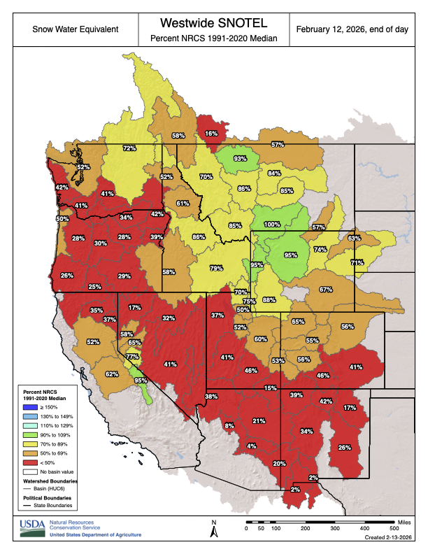
Westwide SNOTEL basin-filled map February 12, 2026.
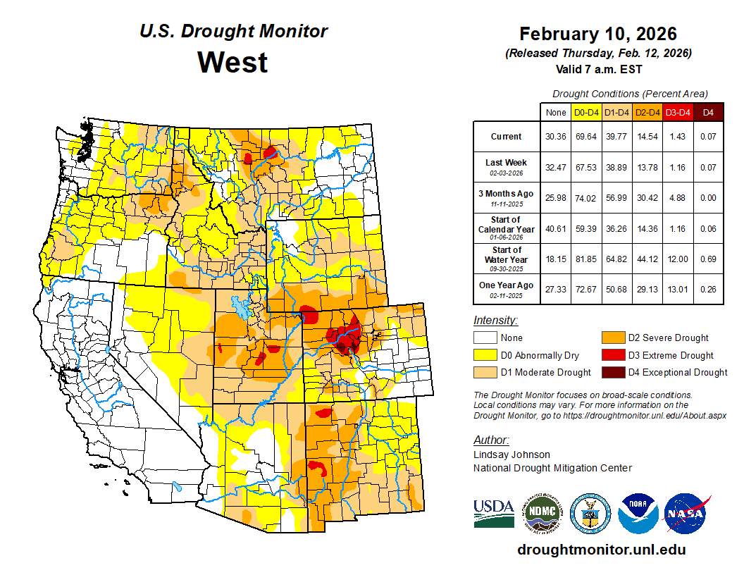
The Lower 48 states and Alaska only saw degradations this week. There was a strong east-to-west temperature gradient again this week, with below-normal temperatures across much of the East and above-normal temperatures across the West. Another week of localized precipitation that missed large portions of the country led to expanding precipitation deficits. Degradations were also scattered across the West, from the Pacific Northwest into the northern and central Rockies, including portions of Oregon, Idaho, Montana, Wyoming and western Colorado. Although some mountain snow fell, critically low snowpack with snow-water equivalent levels below the 15th percentile continues to dominate much of the region and support ongoing drought expansion. Across the High Plains and into the western Midwest, one-class degradations followed another mostly dry week. In the Northeast, despite colder-than-normal temperatures, a continued lack of meaningful precipitation contributed to worsening conditions in parts of Pennsylvania and southern New England. Degradations were also seeing across the South, from the eastern southern Plains of Oklahoma and Texas eastward into the Lower Mississippi Valley and the western Carolinas. Despite scattered precipitation in some locations, short- to mid-term precipitation deficits continue to grow, with drying soils and low streamflows supporting intensification. In southern Georgia and Florida, fire danger continues to rise, with parts of Florida reporting Keetch-Byram Drought Index values between 500 and 700.
In Hawaii, strong trade winds brought heavy precipitation and wind to the windward slopes of Molokai, Maui and the Big Island, where 4 to 10 inches of rain fell at lower elevations and snow at higher elevations, supporting one-class improvements in those areas…
The High Plains saw little to no meaningful precipitation this week, with most of the region receiving less than 25 percent of normal and many locations at or below 5 percent of normal precipitation. Any snowfall was light and offered minimal liquid-equivalent benefit. In eastern Wyoming and eastern Colorado, precipitation deficits continue to deepen with soil moisture percentiles declining, and recent above-normal temperatures led to drying where snow cover is limited. This led to expansion of moderate (D1) and severe drought (D2) across parts of eastern Wyoming and Colorado into the southwest South Dakota, the Nebraska Panhandle and the western Nebraska Sandhills. Similarly, growing short- to medium-term precipitation deficits, below-normal soil moisture percentiles and elevated evaporative demand led to the introduction of extreme drought (D3) to Nebraska’s Panhandle. Eastern Nebraska also saw the expansion of abnormal dryness (D0) as the lack of precipitation has led to drying conditions. Across Kansas, degradations occurred primarily in the northwest, south and along the Missouri border in eastern Kansas following another dry week which, like the rest of the region, added to the growing precipitation deficits and drying soil moisture…
Colorado Drought Monitor one week change map ending February 10, 2026.
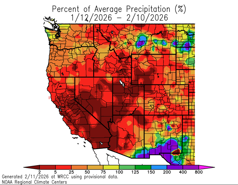
Precipitation across the West this week was light and uneven. Most low-elevation areas in California, Nevada, Arizona, Utah and western Colorado received little to no measurable liquid precipitation, with seven-day totals generally below 0.25 to 0.50 inches. Mountain snow did fall in portions of the northern Rockies and Pacific Northwest, but accumulations were locally light and patchy. Snowpack and Snow Water Equivalent (SWE) percentiles remain well below normal at many SNOTEL sites: much of Oregon, Washington, Idaho, Montana, Wyoming and western Colorado show SWE values in the lowest 15th percentile, with numerous locations in the single digits for this time of year.
Temperatures were above normal across broad areas of the interior West, especially in the Great Basin, central and eastern Wyoming, and northern Colorado, where daytime highs ran 5 to 15 degrees above average at times. These warmer temperatures limited snow accumulation in some basins and contributed to surface drying where snow cover was sparse or absent.
Across the Pacific Northwest, isolated precipitation helped maintain existing conditions in parts of western Washington, Oregon and northern California. However, low SWE percentiles and expanding short- to mid-term precipitation deficits led to the expansion of abnormal dryness (D0) and localized moderate drought (D1) in Washington. Despite seeing precipitation this week, areas of Montana still saw degradations where short- to mid-term precipitation deficits, low soil moisture percentiles and poor snowpack continue to be of concern. Across Utah, Nevada and western Colorado, persistent 2 to 4 month precipitation deficits combined with declining soil moisture and very low SWE percentiles (snow drought) led to further degradations. Many SNOTEL sites in the central Rockies and Great Basin continue to report levels below the 10th percentile for snowpack, with Colorado experiencing its worst snowpack-to-date on record, according to Denver Water and 9NEWS…
Drought conditions across the South continued to deteriorate this week, as much of the region received little to no meaningful precipitation. Most areas recorded below 50 percent of normal rainfall, with many locations under 25 percent of normal. Portions of middle and northeastern Tennessee received 0.5 to 1 inch of precipitation, but amounts were insufficient to offset ongoing 30- to 90-day precipitation deficits. Degradations occurred across the southern Plains into the Lower Mississippi Valley as short- to mid-term precipitation deficits continue to grow across Louisiana, Arkansas and portions of Texas and Oklahoma, with many areas 2 to 6 inches below normal over the past few months. Soil moisture percentiles remain below normal across much of the region and are particularly low in central Louisiana, southern Arkansas and parts of western Oklahoma and South Texas. Streamflows in several basins continue to run below seasonal averages, with some gauges in low percentiles following weeks of limited recharge.
In Deep South Texas, long-term dryness continues to intensify. From August 14, 2025, through February 10, 2026, Rio Grande City ranks as the fifth warmest and third driest on record dating back to 1928, while McCook ranks as the second warmest and sixth driest since 1942 according to NWS and NOAA. A nearby Texas Mesonet site near Hebbronville recorded just 3.81 inches over the past 180 days, and another Mesonet site along the Starr and Jim Hogg County line recorded 11.5 inches, with only 0.33 inches falling during December and January combined. Persistent six-month precipitation deficits and continued warmth reinforced long-term hydrologic stress across the lower Rio Grande Valley…
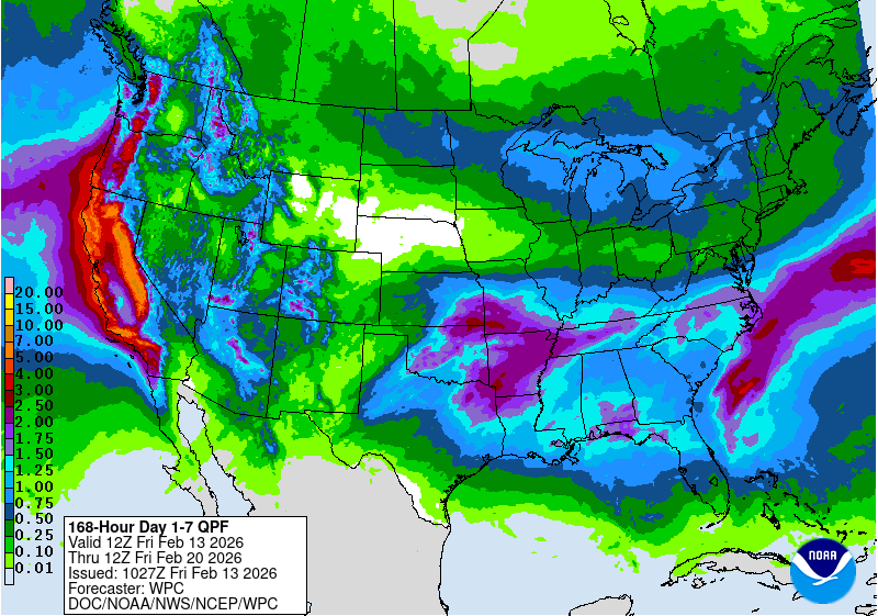
Looking Ahead
Over the next five to seven days (Feb. 12–17), a widespread and active precipitation pattern is forecast across much of the western and southern U.S. The heaviest totals are expected from eastern Texas into Arkansas, where widespread amounts of 3 to 5 inches are forecast, with locally higher totals possible. Additional areas of 1 to 3 inches are expected across much of the lower Mississippi Valley, central Gulf Coast, and into portions of the Southeast. Farther west, widespread precipitation is forecast across California, the Great Basin, and into the central and northern Rockies, where liquid-equivalent totals of 1 to 3 inches are expected, with locally higher amounts in favored terrain. Lighter but still meaningful precipitation is forecast across portions of the Midwest and into parts of the Mid-Atlantic and Northeast. In contrast, much of the northern Plains is expected to remain relatively dry during this period.
The Climate Prediction Center’s 6-10 day temperature outlook (Feb. 17–21) favors above-normal temperatures across much of the central and eastern U.S., including the Plains, Midwest, Ohio Valley and Southeast. The strongest probabilities for above-normal temperatures are centered over the central Plains and lower Mississippi Valley. In contrast, below-normal temperatures are favored across much of the West Coast and portions of the Great Basin. Alaska favors below-normal temperatures across much of the mainland, while Hawaii is favored to see above-normal temperatures.
The CPC 6-10 day precipitation outlook (Feb. 17–21) favors above-normal precipitation across much of the western United States, including California, the Great Basin, and the northern and central Rockies. Above-normal precipitation is also favored across parts of the northern Plains and Upper Midwest. In contrast, below-normal precipitation is favored across the southern tier from southern Texas eastward across the Gulf Coast and into Florida. Much of the central United States, including portions of the Tennessee and Ohio Valleys, is favored to see near-normal precipitation during this period.
US Drought Monitor one week change map ending February 10, 2026.
Biologist David Inouye spent part of his Tuesday afternoon harvesting Jerusalem artichokes from his garden in the 1,400-person town of Paonia in western Colorado.
“It’s been so warm and dry here that my garden’s ready to plant,” Inouye said. “I was actually thinking about maybe planting some spinach or peas this week.”
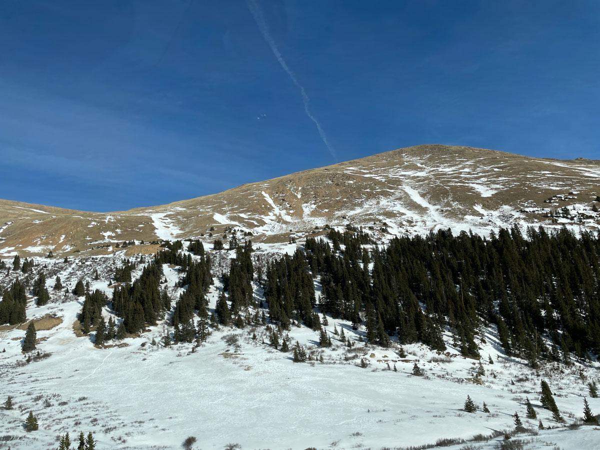
Even with current snowstorms, Colorado’s snowpack this year is, frankly, horrible. The entire state has been in a snow drought with a record-low snowpack. The signs are everywhere: Skiers see it when they hit the slopes. Water providers keep an eye on their reservoir levels and talk about summer watering restrictions. Wildland fire experts gauge fire risk this summer and push people to remove flammable brush from their properties.
Two weeks ago, Inouye skied up to the Rocky Mountain Biological Laboratory near Gothic, where he and other scientists have been conducting research for over 50 years, and saw exposed dirt patches at 9,500 feet of elevation — areas that would normally be buried by snow. Bees, wildflowers, marmots and more could all be affected by this season’s thin, weak snowpack.
Snow showers in this week’s forecast offer a dose of relief, but they won’t be enough to get the state out of a tough, dry year. The Colorado Sun sought out experts from around the state to see what’s going on — and what we need to watch for looking ahead.
Colorado’s winter has been unseasonably warm with so few snowstorms that the mountain snowpack is the lowest it’s been since 1987.
Climatologists are scouring data from high-elevation federal weather stations, called SNOTEL stations, to gauge what this year’s water supply is going to look like. Stations were built over the years until, by 1987, there were enough to provide a comprehensive look at statewide snowpack.
As a headwaters state, snowmelt from Colorado’s mountains runs in all directions to provide water to communities in 19 downstream states before it reaches the Pacific Ocean and Gulf of Mexico.
This year is not quite as bad as two terrible winters in recent memory: 1976-77 and 1980-81. But some smaller watersheds in the state have been dry enough to break even those records, according to state climatologists at Colorado State University’s Colorado Climate Center who analyzed hand-gathered measurements that date back to 1940.
What has really set this water year apart is how warm it’s been, according to the climate center. Colorado just had the third warmest November and the warmest December in over 130 years of records.
Colorado is over 60% of the way through its snow season, which means there’s still some time to avoid a historically bad, record-breaking year statewide. But the chance of getting a normal snowpack becomes slimmer every day, said Peter Goble, assistant state climatologist at the climate center.
The winter storms this week will help, he said. But even if Colorado had a repeat of 2019 — an above-average snow year — from February through April, its snowpack would still be just below normal.
“We have not yet had a year when we were running really low at this point and then just had a magical second half of the snow season and got all the way back,” Goble said.
Visitation is down at ski resorts
The poor snow year has already taken a toll on ski resorts and local economies.
Vail Resorts last month told investors that visitation to its 37 North American ski areas was down 20% through Jan. 4 compared with the previous season. Company CEO Rob Katz pointed to “one of the worst early-season snowfalls in the Western U.S. in over 30 years” — with snowfall at the company’s Rocky Mountain ski areas in Colorado and Utah down 60% from 30-year averages — as the main reason behind the decline.
The company’s Beaver Creek, Breckenridge, Crested Butte Mountain Resort, Keystone and Vail ski areas account for more than a quarter of resort visitation in Colorado, the most trafficked ski state in the country. Vail Resorts is among several resort operators across the state that are cutting hours for workers as visitation ebbs and the lack of snow limits open terrain.
Colorado Ski Country has indicated its 20 members are seeing visitation declines in the “sizable double digits.”
Sales tax reports and end-of-season visitor counts are not due for a few months but several mountain communities are reporting lodging occupancy declines for the season around 10% as the snow-starved season limps further into February.
Meanwhile, the historic drought across the West has led to resort closures. In Oregon, Hoodoo, Mount Ashland and Mount Hood Skibowl have suspended operations as they wait for snow and Willamette Pass ski area is closed for two days midweek.
The thin snowpack left Colorado’s backcountry slopes with low avalanche danger in the middle of the winter, and that’s unusual, Ethan Greene, director of the Colorado Avalanche Information Center, said.
Since Nov. 1, CAIC has counted 31 people caught in avalanchesresulting in three injuries and no fatalities. That compares to 28 people caught in avalanches through mid-February in the 2024-25 season, resulting in three injuries and zero deaths. In the same span of the 2023-24 winter, CAIC tallied 47 people caught in avalanches, with three injuries and two deaths.
For winter sports enthusiasts, more dry days won’t be a great outcome, Greene said. More storms increase avalanche danger, but they also improve riding conditions.
This week’s winter storms bumped the danger level in northern Colorado to moderate and considerable levels Wednesday, up from a low danger rating Tuesday, based on the center’s avalanche danger map.
“We have a very thin and very weak snowpack,” Greene said. “It’s not posing a lot of danger right now, but if we go into a really active weather pattern that could change pretty substantially.”
City water also increasingly in doubt
Near-term droughts are a golden opportunity for Colorado water agencies to tap their long-standing signs declaring the need for more reservoir storage.
The water provider’s reservoirs are at 60% of capacity, which is lower than the city wants to see for this time of year, particularly with a record-low snowpack, Aurora Water spokesperson Shonnie Cline said. The region would have to get all of its normal snowfall — plus another 50% — over the next two months to get back to average.
The city council will soon decide whether it will declare deeper drought restrictions for this summer, she said. Restrictions aren’t out of the question for another big Front Range water provider, Denver Water, which serves 1.5 million people in Denver and surrounding suburbs.
Denver Water draws 90% of its water supply from the mountain snowpack in the Colorado River and South Platte basins. The snowpack near its water diversion tunnels and pipelines in these basins was 55% and 42% respectively as of Monday.
Northern Water, which serves community water agencies and ditches for 1.1 million people and 615,000 acres, said reservoir storage levels for its Colorado-Big Thompson Project are higher than in previous looming snowpack droughts.
That project “was built for years just like this one — where a low water supply threatened the ability of the farms and cities in our region to produce the economic benefits expected,” Northern Water spokesperson Jeff Stahla said. “What that means is that we have enough water in storage right now to ensure crops get out of the ground and cities can produce the materials needed for this upcoming high-demand season.”
Northern Water has also been in talks for months with members who had bought into a $2.7 billion, two-reservoir and pipeline plan to add storage along the Poudre and South Platte rivers. Some communities have signaled they will drop out because of the massive project’s rising costs, while Northern Water has pointed to communities that stayed in because they need supply for future growth and stability.
The dozen-plus community water agencies receiving Northern Water this year, though, will have to consider drought savings measures.
“We anticipate that communities within our boundaries will likely put in place policies to ensure we don’t waste any water and can ensure that we use the stored water for as long as possible,” Stahla said.
On Thursday, Northern Water’s board will hear a proposal to tap into an additional pool of water, called the administrative pool, that wasn’t used last year. The board will have to consider the possibility that this year’s drought might last longer than one season as it considers how much to draw from reserves, Stahla said.
A deep drought from 2000 to 2002 cut into their reservoir storage and supplies, depleting it so much that it took seven years to recover, he said.
“We recognize that we should be thinking about many variables as we look to release water for 2026,” Stahla said.
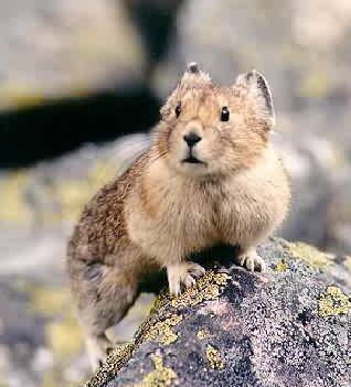
It could get too cold for the pikas
The low snowpack could have impacts on critters in the high country.
“Pikas depend on snowpack to insulate them from cold winter temperatures at high elevations, so the low snowpack could potentially make it harder for them to survive the winter,” said Megan Mueller, a conservation biologist with nonprofit Rocky Mountain Wild.
Through the Colorado Pika Project, a partnership between the nonprofit and the Denver Zoo, community scientists collect data in Colorado’s mountains in the summer to help scientists better understand the pika population and how it is being impacted by climate change.
Because the surveys take place in the summer, Mueller said it’s not yet clear what consequences this year’s dry weather will have on pikas. But existing research shows pika populations have gone extinct at sites where winter snowpack was insufficient for insulating them from the extreme cold.
Volunteers seeking to help scientists better understand the impact of this year’s snowpack on Colorado’s pikas can sign up online to join the Pika Patrol.
Ground squirrels, marmots, chipmunks, bears and other mountain mammals might have to use more energy to stay warm in their habitats without that snowy insulation. Burning energy faster could mean some will starve or emerge from hibernation earlier, according to Inouye with the Rocky Mountain Biological Center.
And just like mammals, insects and plants struggle in warm, dry winters.
Colorado has about 1,000 species of native bees, many of which spend winter underground and depend on the snowpack’s insulation.
Inouye has been watching how wildflowers, like aspen sunflowers and larkspurs, bloom in different conditions since 1973. Flowers start to bloom as soon as snow melts. With a thin snowpack, that melt could happen in mid-April, especially on sunnier, south-facing slopes. Wildflowers will start to bloom early and could be stunted by hard freezes that can typically appear through early June.
An early, sparse bloom affects pollen resources, which are key for bumblebees and migrating hummingbirds as they nurture larval bees or lay eggs, Inouye said.
“It’ll certainly be a very early season for the blooming of the wildflowers,” he added. “That’s typically associated with lower numbers of flowers.”
Fire managers fear early start to fire season, severe wildfires
This year’s low snowpack has wildfire managers fearing an early start to fire season and severe fires as the temperatures rise, especially along the Front Range.
“We haven’t seen anything quite like this in 30 years,” the state fire division’s planning section Chief Rocco Snart said.
The lack of snowpack this year reminds Snart of the conditions that led to the “horrific fire seasons” in 2000, 2002 and 2012.
“They were in the same realm as where we’re at today. But now we’re worse than those,” he said.
n those years, more than a dozen notable wildfires ignited amid extremely dry conditions. Hundreds of thousands of acres burned across the state and hundreds of homes were destroyed. In 2000, two human-caused fires destroyed 80 homes on the Front Range, while another fire sparked by lightning scorched 23,607 in Mesa Verde National Park, according to the National Weather Service.
In 2002, six massive fires sparked across the state, including the arson-caused Hayman fire that charred more than 137,000 acres across five Front Range counties and became the largest wildfire in Colorado history at the time. Five firefighters died and more than 600 structures were destroyed.
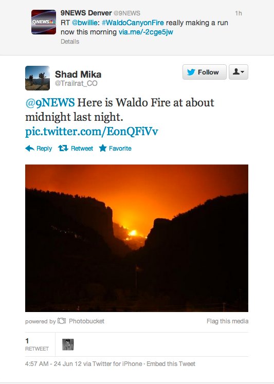
Waldo Canyon Fire
And in 2012, six massive wildfires rapidly spread amid extreme drought. Among them was the Waldo Canyon fire, which scorched 18,000 acres near Colorado Springs and destroyed 346 structures. Two people died.
If Colorado doesn’t start to see more precipitation soon, Snart said he fears wildfires will begin igniting much earlier than previous years, in March or April, and be fueled by winds. Vegetation will be dry as no new growth will have sprouted by then.
Snart sees wildfire risk along the Front Range as “especially problematic” because it picks up down-sloping winds from the mountains which are a “prime driver” of early season fires.
Fire risk is also very high along parched lower elevations of the Western Slope, he said.
Residents can take advantage of the warmer weather and start mitigating areas around their homes and being cautious of any activity that could cause sparks, especially on windy days, Snart said.
Jared Gardner apologizes for the interrupting beeps from his tractor’s GPS system as he makes his way across the family’s 3,500-acre farm near Rocky Ford. But he explains that it’s a different technology — the data on his smartphone — that grabs his attention multiple times each day as he considers the fate of the fields where he cultivates alfalfa, corn, sorghum and a mix of watermelons, cantaloupes and pumpkins.
Snowpack numbers, harvested from SNOTEL sites, influence planting in this agricultural corridor of the Lower Arkansas Valley. Snowpack determines runoff, which determines the flows of the Arkansas River, which determines what to grow and what to avoid.
When Gardner Farms plots out a two-year plan for crop rotation, it begins with a best-case scenario of conditions, untethered to limitations of drought. Closer to planting time, lower water estimates may steer operations to a Plan B, which might mean trimming back acreage for the thirstiest crops.
“My brother and I are probably on Plan C or D already, looking at this snowpack,” Gardner said. “It would take a small miracle to turn this thing around in a fashion that you’d say I have an ample supply of water. So for us, the first thing I do is pull corn back, to grow something with the yields that you need to break even in this marketplace. There’s not a lot of wiggle room for failure.”
A little more than an hour east on U.S. 50 near Lamar, Dale Mauch pays less attention to the snowpack numbers than the long-range weather forecasts, which he checks two or three times a day to gauge the fortunes of his 4,000 acres of hay, corn, wheat, oats and sorghum.
“The transition is supposed to be coming, but it may not be here till May, which could be too late for this year’s snowpack,” Mauch said, noting that his planting plans remain uncertain amid some forecasts that predict up to four feet of snow over the next few weeks.
Colorado Drought Monitor February 10, 2026.
“The silver lining for us down here by Lamar is we’ve had some storms with pretty good moisture,” he added. “So as far as being dry, we’re not in that bad of shape. We’re in better shape than the mountains right now.”
Overall, experts say the outlook for farmers — and ranchers, whose livestock rely on the same snowpack — leans away from optimism.
“It’s pretty grim,” said Kristen Boysen, managing director of the state Agriculture Department’s Office of Drought and Climate Resilience. “Producers are definitely bracing for the worst, but I don’t think anyone has changed their plans yet.”
Final decisions on what crops to plant, the size of cattle herds based on available water, and where to find extra grazing pastures or hay supplies all need to be made at most farms and ranches within a month, Boysen said. Even if agriculture sees snow over the mountains in the next few weeks, she added, the growing season may already be compromised.
“Across the state, we’ve seen so little moisture, so the soil is really dry,” Boysen said. “So any runoff we get from the mountains will just get sucked up so fast by the soil. And I think peak runoff will be very early. I think they’re crossing their fingers that it rains on their farm.”
Back in Rocky Ford, Gardner remains hopeful that a cold front forecast for the coming days might generate moisture to fulfill a farmer’s innate optimism. But even a foot or so of snow in the mountains probably won’t translate, in the long run, to much relief.
“Unless we just get an epic blizzard in the mountains, that sort of snow is kind of a Band-Aid for a bullet hole right now,” Gardner said. “And Colorado knows that. I think everyone in Colorado understands what a lack of snowpack means to the state, whether you ski on it, or irrigate with it, or just want to drink it.”
Colorado Sun reporters Olivia Prentzel, Michael Booth, Kevin Simpson and Jason Blevins also contributed to this report.
Synopsis: A transition from La Niña to ENSO-neutral is expected in February-April 2026(60% chance), with ENSO-neutral likely persisting through the Northern Hemispheresummer (56% chance in June-August 2026).
La Niña continued in January 2026, with below-average sea surface temperatures (SSTs) observed in the east-central equatorial Pacific Ocean. The latest weekly Niño-3.4 index value was -0.9°C, with the westernmost (Niño-4) and easternmost (Niño-1+2) indices at -0.4°C and 0.0°C, respectively. The equatorial subsurface temperature index (average from 180°-100°W) significantly increased, reflecting the strengthening and expansion of above-average subsurface temperatures across the Pacific Ocean. Atmospheric anomalies weakened due to subseasonal variability, but still reflected aspects of La Niña. Low-level westerly wind anomalies were present over the western equatorial Pacific, and upper-level westerly wind anomalies continued across the east-central equatorial Pacific. Suppressed convection was weakly evident near the Date Line and over the equatorial Maritime Continent, with enhanced convection located off the equator. The traditional and equatorial Southern Oscillation indices were positive. Collectively, the coupled ocean-atmosphere system remained consistent with La Niña.
The North American Multi-Model Ensemble (NMME) average, including the NCEP CFSv2, favor the onset of ENSO-neutral in February-April 2026. The team consensus also reflects this outcome, with ENSO-neutral persisting through the Northern Hemisphere summer 2026. For the late summer and beyond, there is a 50-60% chance of El Niño forming, though model uncertainty remains considerable and forecasts made this time of year tend to have lower accuracy. In summary, a transition from La Niña to ENSO-neutral is expected in February-April 2026 (60% chance), with ENSO-neutral likely persisting through the Northern Hemisphere summer (56% chance in June-August 2026.