Soil-moisture system will yield information for farmers, foresters and forecasters — Christopher Outcalt (#Colorado State University)

Helen Silver has helped lead a statewide effort to improve soil-moisture monitoring and to make data widely available. She is co-director of the Integrated Rocky Mountain-region Innovation Center for Healthy Soils. Photography: Matthew Staver.

Click the link to read the article on the Colorado State University website (Christopher Outcalt):

February 10, 2026

Key takeaways

  • CSU scientists have installed dozens of new soil moisture monitoring sensors across the state, increasing capacity by 60%, and have received additional funding to install more sensors this year.
  • Researchers have also launched a new web-based platform that allows anyone to view both historical and real-time statewide soil moisture data.
  • Interest in soil moisture is skyrocketing, and the data is useful to farmers, foresters, scientists, water managers, weather forecasters and others.

Colorado State University is leading an effort to track a critical but unseen resource in Colorado: water stored in soil. This statewide effort to enhance soil moisture monitoring is producing important insights that can help everyone from farmers to weather forecasters better predict water supplies, understand the risk of wildfire and assess the impacts of drought. 

“Soil moisture is one of the most under-monitored natural resources, yet it is a foundational driver of ecosystem services and risk management,” said Helen Silver, co-director of CSU’s Integrated Rocky Mountain-region Innovation Center for Healthy Soils, or IN-RICHES, which is helping to lead the work. “Because soil moisture data are both scarce and difficult to access, this project addresses both challenges by expanding monitoring infrastructure while making the resulting information openly available and usable for land managers, policymakers and researchers.”

In Colorado, estimates suggest that the amount of water stored in soils is more than twice the amount that flows on the surface. As the Western U.S. faces growing challenges with water availability due to drought, climate variability and competing demands, there is heightened interest in better understanding and monitoring this critical resource. The work is being done in collaboration with the Colorado Climate Center and the CSU’s Department of Computer Sciences.

Historically, soil moisture monitoring in Colorado has been concentrated in high-elevation mountains, with croplands and forests underrepresented. This imbalance has limited the ability of land managers and others to fully understand soil-water dynamics across areas where water scarcity, wildfire risk and agricultural drought are most acute.

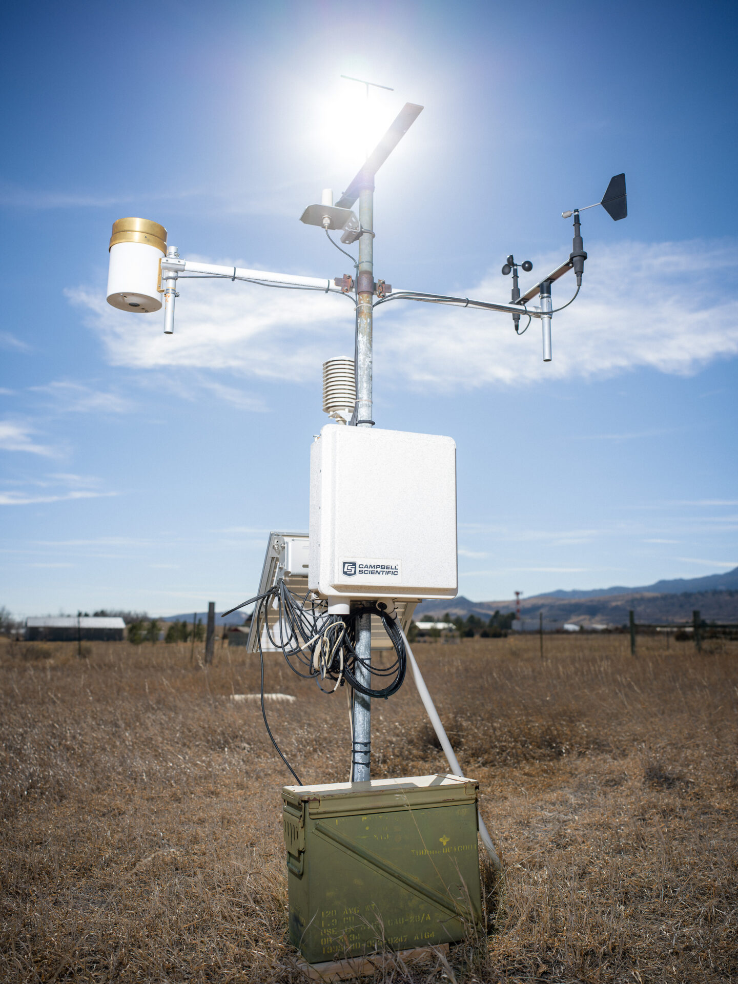
Aimed at filling this critical gap, the federal government allocated $1.45 million to CSU in spring 2023 to lead an expansion of the number of in-ground sensors, create a publicly available platform to increase access and expand other precipitation monitoring efforts. From May to October, a team of researchers installed 64 additional sensors at underrepresented sites across the state, expanding Colorado’s monitoring capacity by roughly 60%. This project was known as the Colorado Open Soil Moisture Monitoring Network. CSU recently received additional funding from the state’s Colorado Water Plan Grant Program to install another 15 sensors this year. 

In addition to installing new sensors, CSU has launched Quench, a web-based monitoring platform that collects real-time soil moisture data from multiple networks into a single location.

An above-ground apparatus is connected to below-ground moisture sensors that help scientists understand the amount of water stored in soils. Photo credit: Colorado State University

Beneficial collaboration

There are several entities monitoring soil moisture in Colorado, including the U.S. Department of Agriculture’s Natural Resources Conservation Service, which operates snow telemetry, or SNOTEL, sites; the Roaring Fork Observation Network, supported by the nonprofit Aspen Global Change Institute; and the CSU-run Colorado Agricultural Meteorological Network, which operates automated weather stations capable of tracking soil moisture. 

Quench is the first centralized tool for viewing all available soil moisture data, including historic data, in Colorado. 

“The integration of soil moisture data into a single platform is a monumental advancement,” said Megan Machmuller, IN-RICHES co-director and a research scientist in CSU’s Soil and Crop Sciences Department. “This publicly accessible tool will streamline comparisons across the state, providing critical insights for managing water resources and proactively addressing risks.”

Expanding the soil moisture network and launching Quench involved input from dozens of water managers, farmers and ranchers, researchers, and state and local officials. Elise Osenga, who works for the University of Colorado in partnership with the National Oceanic and Atmospheric Administration’s National Integrated Drought Information System, said she appreciated the collaboration. “There’s so much interest in soil moisture, especially in the Western U.S., because of recent intense droughts,” Osenga said. “But a lot of people aren’t really sure where to find that information.” 

She added, “This work is beneficial not just for the information itself, but also as a model of collaboration; CSU did a great job of reaching out to different groups to develop this platform.” 

Eric Schroder, a soil scientist with the U.S. Forest Service, is looking forward to sharing Quench with Forest Service personnel in Colorado. “The ability to easily access real-time soil moisture data from multiple partner networks and explore historical trends to see how conditions are changing over time will support and improve our ongoing management of USFS lands in Colorado,” Schroder said. 

Schroder emphasized that the Forest Service relies on soil moisture data to support disaster preparedness and to inform ongoing land and water management operations, including fire prediction, controlled burn operations, drought forecasting, landslide risk, flood risk, reforestation initiatives and timber management. 

In addition to installing new sensors, the CSU team plans to continue to upgrade Quench, eventually integrating satellite-based soil moisture data and other features. 


Helen Silver | Co-director of IN-RICHES

Soil science • Soil water dynamics • Drought and water resilience • Soil data systems

Helen Silver is an environmental policy expert focused on soil health, water and sustainable food systems in the Rocky Mountain West, bridging science, law and data to support farmers, land managers and climate resilience efforts.


Arrange an interview

The Quench Open Knowledge Platform brings data collected from in-situ soil moisture sensing stations across a range of monitoring networks into one easy-to-use platform. Users can view current conditions, compare trends across regions, and access satellite-derived soil moisture data.

With no end in sight to dry days and high #wildfire risk, #Colorado eyes multiagency task force — Jerd Smith (Fresh Water News) #drought #aridification

West Drought Monitor map February 24, 2026.

Click the link to read the article on the Water Education website (Jerd Smith):

February 26, 2026

Colorado has started preliminary planning for a multiagency drought task force to help cope with what most experts fear will be a summer seriously low on water and high on wildfire risk.

The task force would include agencies focused on water, agriculture and emergency management, among others, according to Emily Adrid, water planning and climate impact specialist at the Colorado Water Conservation Board. Her comments came at a meeting of the state’s Water Monitoring Committee this week. When the task force could launch hasn’t yet been determined.

The last time such a task force was called into action was in the 2020-21 drought, according to the board. If needed, the task force can work with ad hoc groups and the governor’s office to coordinate release of state emergency funds.

The news comes as Colorado continues to struggle with a deeply dry and warm winter and forecasts showing the trend continuing this spring.

Colorado measures its water supplies using a calendar that runs from Oct. 1 through Sept. 30, a period known as the water year.

The first four months of the 2026-27 water year are the warmest in 131 years, said Russ Schumacher, state climatologist at Colorado State University’s Colorado Climate Center.

“This is breaking the record by a huge margin,” Schumacher said.

And there is little if any relief in the spring forecasts.

“We might hope for a miracle this spring,” he said, “but this is not what’s in these forecasts.”

Statewide reservoir storage levels are holding steady above 80%, but streamflow forecasts indicate Colorado is likely to receive just 63% of its normal water flows, and possibly less, according to the Natural Resources Conservation Service in Lakewood.

In response, cities will also coordinate efforts to alert the public to the potential for water and fire emergencies. Their hope is that a unified approach to watering restrictions will reduce water use.

The city of Westminster is among cities gearing up for an ultradry summer. Drew Beckwith, the city’s water resources manager, said getting plans in place early and encouraging everyone to share the same message will be critical this year and next.

“We haven’t had a big drought since 2002,” Beckwith said. “We’re all out of practice.”

Even if major spring snowstorms occur that could lessen water shortages and fire risks, 2026 is still expected to be strikingly dry and warm.

And that is not as worrisome as the prospect of a follow-on drought in 2027, Beckwith said.

“It’s not the one-year drought that is our Achilles’ heel,” he said. “It’s multiple dry years in a row when things get concerning. Since we don’t know what next year’s snowpack is going to look like, we don’t want to not do anything. Instead, we’re saying, ‘Hey, we don’t know what’s going to happen so let’s all get on the same page now.’”

More by Jerd Smith

The pine beetles are back. Here’s why—and what you can do about it — Yvaine Ye (CU Boulder Today)

A moutain pine beetle chewing on a tree. (Credit: Colorado State Forest Service)

Click the link to read the article on the CU Boulder Today website (Yvaine Ye):

January 28, 2026

Colorado’s warm and dry winters have tipped the balance in a long-running ecological tug-of-war.

The mountain pine beetles, native insects to the Centennial State, have recently exploded in numbers in the Front Range after a decade of relatively low populations. The mild winter temperatures have allowed more beetle larvae to survive, while the lack of water has weakened pine trees’ natural defenses against the bugs. 

Already, thousands of pine trees along the U.S. 285 and I-70 corridors are turning brown. The devastation prompted Gov. Jared Polis to sign an executive order in December to slow the spread of the beetles. 

“A very high level of tree mortality, especially among ponderosa pines, is likely to continue for the next decade,” the order warned

But the insects are not the antagonists of the story, said Samuel Ramsey, assistant professor in the Department of Ecology and Evolutionary Biology and the BioFrontiers Institute. 

Samuel Ramsey looking at a beehive in his lab. (Credit: Patrick Campbell/CU Boulder)

“They are doing exactly what evolution has primed them to do, and they are just able to do it to the maximum because of the ways that climactic contexts have shifted.  That is our fault,” he said.

The impact extends beyond tree loss. For the Front Range, a densely populated region already under persistent wildfire threat, dead trees can exacerbate risk. 

To unpack what’s behind the outbreak and what may come next, CU Boulder Today sat down with Ramsey to chat about its causes, the outlook for Colorado’s forests and steps people can take to limit the damage.

The Mountain pine beetles are native to Colorado. Why are they causing problems now?

As the climate has shifted, it has knocked the beetles out of their normal balance with the trees.  Because the weather has been warm for longer stretches of time, these beetles are able to produce an additional generation of babies, in addition to the dozens of offspring they usually produce.

An adult mountain pine beetle. (Credit: Colorado State Forest Service)

How do the pine beetles attack trees?

The mountain pine beetles are smaller than a grain of rice. When a single pine beetle attacks a tree, it actually can’t do much damage.  So, when a pine beetle locates a tree, it will release a smell that tells all the pine beetles in the area to come and attack it. When 1,000 pine beetles all attack the same tree, some get through and lay eggs in the tree. Once inside, the beetles will gum up the tree’s vascular system, cutting off its water and nutrient supply. 

Do trees have a defense mechanism for keeping beetles out?

They did in the original climactic circumstances, such as secreting sap to push out the beetles. But when there isn’t enough water, they can only produce a small amount of sap, and that is not enough to fend off thousands of beetles that just keep coming at them.

With the warm weather, pine beetles are also maturing faster. That means the trees are starting their battle against the beetles earlier than they had planned. The trees are also fighting later into the season because of the additional generation of beetles.  

How bad will this round of the outbreak be?

I’m not a prognosticator, so I cannot tell you that this is going to be a terrible year. But the data is pointing in the direction. In the past, when we have had the same set of circumstances, we have had a banner year for mountain pine beetles. It is estimated that out of more than 4 million acres of pine forests across the state, more than 80% were damaged by the beetles between 1996 and 2013.

This winter has been really warm. That means that more pine beetles are going to survive the winter. So starting this year, their population will be large enough to likely overcome the defense of a lot of these trees. We could have dead stands of pine trees just sitting there ready to welcome the next wildfire.  

Are mountain pine beetle outbreaks unique to Colorado?

The mountain pine beetles are distributed in many parts of North America, but Colorado kind of has a perfect storm of circumstances. We have these issues with a warmer winter. Really high winds can help these pine beetles move farther distances when they’re flying. In addition, the wind can drive wildfires. Together, those factors make the risks here especially high. 

Are there any actions individuals can take to reduce the damage?

There are ways that we can lean into our agency here.

If you have a pine tree in your yard, you need to make sure that it has adequate water by watering it and reducing competition for water from other plants around it.  

If you are getting firewood, get it and burn it locally. It’s a really, really bad idea to move firewood, because you could inadvertently help spread the beetles.  

If you’re seeing mountain pine beetles in your area, and you haven’t seen that before, contact your local forest service office. 

The pheromone packets people used in the past might not be the best solution, because they won’t stop an infestation, and sometimes they can make the problem worse by drawing more beetles to an area than would’ve arrived otherwise.

As the climate continues to warm, these sorts of ecological issues are going to happen more often. So we need to make sure that instead of only treating the symptoms of climate change, we are reducing the amount of carbon that is going into the atmosphere. 

d
Mountain Pine Beetle kill via USGS.

Accelerated Global Warming Could Lock Earth Into a Hothouse Future: Scientists say warming is increasing faster than at any time in at least 3 million years. There is no guide for what comes next — Bob Berwyn (InsideClimateNews.org)

Climate tipping points are key thresholds in Earth systems like oceans, ice sheets, and forests, where warming can push the climate into a new state. Once crossed, these changes can be hard to reverse and can start a chain reaction that affects ecosystems, weather extremes and the global climate. Credit: ESA

By Bob Berwyn

February 11, 2026

This article originally appeared on Inside Climate News, a nonprofit, non-partisan news organization that covers climate, energy and the environment. Sign up for their newsletter here.

If you think of Earth’s climate system as a backyard swing that’s been gently swaying for millennia, then human-caused global warming is like a sudden shove strong enough to disrupt the usual arc and buckle the chains.

And if humans keep heating the planet with greenhouse gas pollution, the climate swing could lock Earth into a hothouse trajectory, as parts of the system feed on their own momentum, even if emissions are reduced later, an international team of scientists warned Wednesday in a new paper published in the journal One Earth. 

Their analysis covers 16 key Earth systems, including oceans, ice sheets and forests, that are likely to destabilize if the planet continues to warm. If large parts of the Amazon rainforest and tropical coral reefs die, they absorb less carbon dioxide, triggering a dangerous chain reaction of warming.

If Earth’s climate starts on a hothouse trajectory, it would represent a “global tipping point” as the heating sustains itself even if greenhouse gas emissions drop, said lead author William Ripple, a distinguished professor of ecology at Oregon State University and a leading researcher on climate tipping points.

In the backyard, that’s the moment when the push is so hard that the swing hesitates at the top, just long enough to show that the ride may not be under control anymore and the chains are being tested.

“What typically took thousands of years is now happening in decades,” Ripple said, adding that human-caused warming is already nudging the climate system out of 11,000 years of relative stability with good conditions for farming and societal development.

Earth could be entering a period of unprecedented climate change on a one-way trajectory, in which processes such as ice-sheet collapse can continue even if the average global temperature is stabilized, he said.

In a new paper, William Ripple, an ecologist and climate researcher at Oregon State University, warns that human-caused warming could put Earth on a hothouse trajectory. Credit: Courtesy of William Ripple

Recent observations suggest that the climate may be responding more strongly than some models predicted, Ripple added. “We are concerned that policymakers and the public may not yet be aware of these recent developments.”

In late January, another group of leading climate scientists urged policymakers to adopt a climate goal of limiting human-caused warming to 1 degree Celsius above the pre-fossil fuel era, which is more ambitious than the 1.5 to 2 degrees Celsius target set in the Paris Agreement. They’ve also recently reported that Earth is losing its reflective sheen, which amplifies warming, and that key ocean currents are changing in ways that destabilize the entire global climate system. 

But it’s not clear if the scientific warnings are making a difference in “a post-truth era in which too many people prefer pleasant lies over unpleasant truths,” said Reinhard Steurer, a professor of climate policy and governance at the University of Natural Resources and Life Sciences in Vienna who studies how climate science and policy interact. He said that new studies outlining disastrous scenarios are unlikely to have much impact in the current political climate, but that researchers should keep speaking out, and not surrender to “techno illusions or hopium.”

The authors of the new paper stressed that a self-sustaining hothouse trajectory is not the same as a Hothouse Earth state, which would be when the global climate rebalances at a much hotter average temperature.

No Good Analog Climates

Instead of offering a single new climate forecast, the paper synthesizes decades of research revealing how different parts of the climate system influence one another. When one part of the system is destabilized, they wrote, it can amplify stress in others, pushing the planet along a self-reinforcing warming pathway. 

Earth has had hothouse climates in the ancient geological past. But the authors of the new paper said there may not be a parallel to what’s happening now, at least not during the past 3 million years, co-author Johan Rockström, co-director of the Potsdam Institute for Climate Impact Research, said via email. 

“The reason is that our starting point is a WARM state. So, we are going from WARM to HOT,” he wrote. This may mean “getting stuck” at a global mean surface temperature of 4 to 6 degrees Celsius above pre-industrial levels, he added. 

That amount of warming goes beyond current expectations and would devastate ecosystems and communities globally. Many other current climate projections suggest that, under current policies, warming would level off somewhere between 2.7 and 3 degrees Celsius.

Human-caused warming is happening much faster than any other warming documented in the paleoclimate record, and it’s also unprecedented because it’s driven by a single dominant force, Rockström added: human greenhouse gas emissions. Under these conditions, research has documented that Earth is already losing some of the natural buffers that dampened climate swings in recent millennia.

“We now see worrying signs that the Earth system is losing resilience,” Rockström said. Recent extremes, he added, are a sign that the climate system “may respond more strongly to the same amount of warming than it did before.”

The authors wrote that the magnitude and pace of recent climate extremes “have surprised scientists, raising questions about how well current climate projections capture risk.”

One warning sign is the recent acceleration of warming, from about 0.18 degrees Celsius per decade from 1970 to 2014, to about 0.26 degrees Celsius in the last decade; another is the reduced carbon uptake in tropical, temperate and boreal forests. And, Rockström added, “Earth is getting darker, due to multiple factors,” including melting ice, tree lines moving closer to the poles in the Northern and Southern hemispheres and changing cloud patterns due to increased evaporation and moisture in the atmosphere.

The recent acceleration of warming was also noted recently by climate scientist James Hansen, a former NASA researcher who has accurately projected the planet’s global warming trajectory for several decades.

In a climate bulletin published last week, Hansen wrote that a current shift toward a warm tropical Pacific Ocean phase could push Earth to a new temperature record this year or next, potentially surpassing 2 degrees Celsius above the pre-fossil-fuel era benchmark sometime in the 2030s.

“Don’t be too pessimistic as the evidence for high climate sensitivity grows,” Hansen wrote in his Feb. 6 update. “Realistic understanding of the climate situation, and public recognition of that, is the essential first step toward successfully addressing climate change.” 

The science shows that climate stability is no longer guaranteed, Rockström said. Choices made this decade, he said, could shape the Earth System for generations.

Desperate in failing #ColoradoRiver negotiations, #Wyoming water officials pitch conservation bill at home: Historically bad snow and water conditions raise stakes for ColoradoRiver basin states as feds prepare to intervene — Dustin Bleizeffer (WyoFile.com) #COriver #aridification #GreenRiver #NorthPlatteRiver

Evening light hits the bluffs above the Green River at Fontenelle Reservoir in June 2021. (Ryan Dorgan/WyoFile)

Click the link to read the article on the WyoFile website (Dustin Bleizeffer):

February 18, 2026

Historically bad snow and water conditions raise stakes for Colorado River basin states as feds prepare to intervene.

Wyoming water officials are desperately hoping to avoid a federal intervention into the high-stakes deadlock among Colorado River stakeholders seeking a compromise on shared water appropriation cuts.

Wyoming and the six other Colorado River basin states blew through another deadline Saturday to come to an agreement, raising the possibility that the U.S. Bureau of Reclamation will dictate a new drought response plan — a situation that could dash cooperation and spawn intense legal entanglements, observers say.

Making matters worse is an intense “snow drought” so far this winter that’s compounding a “mega drought” across much of the seven-state basin region that’s lingered for more than two decades. It’s so dry that federal water managers warn Lake Powell — for the first time in 63 years — could drop 50 feet, low enough to no longer produce hydroelectric power at the Glen Canyon dam, according to the Bureau’s latest projections

The intense situation was a topic of discussion Tuesday as a legislative committee considered a bill — Senate File 84, “Voluntary water conservation program.” The Wyoming State Engineer’s Office hopes it will give the state some negotiating leverage and protection over the state’s share of Colorado River-bound water.

Jim Magagna, the executive vice president of the Wyoming Stock Growers Association, speaks at a September 2025 Wyoming Game and Fish Commission meeting in Lander. (Mike Koshmrl/WyoFile)

“Our governor traveled back and met with other governors in D.C. and gave a somewhat favorable report,” Wyoming Stock Growers Association Executive Vice President Jim Magagna told the Senate Agriculture, State and Public Lands and Water Resources Committee. “The day after that, the state engineer in Arizona announced that they’re willing to go to court and fight to the death to get the water they think they’re entitled to from the upper basin, [which includes Wyoming].

“I would love to be able to sit here and tell you this is totally unnecessary,” Magagna said, adding he’s in favor of the bill. “Unfortunately, the scenario we’re facing in the Colorado River today is that we do believe that the state needs to show some good faith in attempting to address some of those water issues.”

The committee also heard from representatives of Wyoming’s prolific trona and soda ash producers, who rely on water that is subject to the Colorado River Compact

“We have 2,300 employees at risk in southwest Wyoming if we don’t find a solution,” Jody Levin told the committee, speaking on behalf of the trona industry and the Wyoming Mining Association.

Divvying up shrinking water

Water forecasts were already so dire in January that the Wyoming State Engineer’s Office warned that Colorado River water managers will likely call for a significant drawdown of Flaming Gorge Reservoir this spring. The reservoir, straddling the Wyoming-Utah border, is one of the primary backups in the upper Colorado River system to ensure operational water levels at Lake Powell.

Flaming Gorge’s function as a backup is merely one piece of a complex Drought Response Operations Agreement among Colorado River stakeholders, and it expires later this year. Renewing the DROA, along with other binding agreements that dictate appropriations throughout the river system, requires determining how to share a shrinking water resource that serves 40 million people from the Cowboy State to Mexico. Though Wyoming and other Colorado River stakeholders say they prefer their own compromise over a federal one, they have yet to strike a deal — despite years of negotiations.

The Bureau of Reclamation in January published its own draft environmental impact statement for a new plan, and last week the agency hinted that time is running out for a compromise among states.

The Blacks Fork, a tributary to the Green River, near its confluence at Flaming Gorge Reservoir in May 2018. (Ryan Dorgan/WyoFile)

“The basin’s poor hydrologic outlook highlights the necessity for collaboration as the Basin States, in collaboration with Reclamation, work on developing the next set of operating guidelines for the Colorado River system,” Acting Bureau of Reclamation Commissioner Scott Cameron said in a prepared statement Friday. 

Gov. Mark Gordon, along with fellow Colorado River upper basin states’ Govs. Jared Polis, Michelle Lujan Grisham and Spencer Cox, issued a joint statement Friday ahead of the unmet deadline. 

“Upper basin water users live within the means of the river by adapting our uses every year based on available supplies,” the governors said. “We continue pursuing a seven-state consensus, which would provide greater opportunity to pursue federal funding supporting conservation efforts and innovative water-saving technologies across the basin.”

The Platte River is formed in western Nebraska east of the city of North Platte, Nebraska by the confluence of the North Platte and the South Platte Rivers, which both arise from snowmelt in the eastern Rockies east of the Continental Divide. Map via Wikimedia.

Though not part of the Colorado River system, the North Platte River,  stretching from south-central to eastern Wyoming, is also parched. The State Engineer’s Office issued a “priority administration” order earlier this month, requiring junior rights water holders along the river system to immediately cease diverting water. The order could remain in effect through April.

Water conservation bill

Senate File 84 cleared the Senate Agriculture Committee Tuesday [February 17, 2026] unanimously, with strong support from stakeholders beholden to the Colorado River Compact and some doubters.

It would enshrine a water conservation strategy that’s already been tested for several years in the state. It would allow ranchers and other Colorado River system users in Wyoming to voluntarily use less water without losing their appropriation rights, according to the bill. 

“It helps avoid mandatory and uncompensated water use reductions, whether by court order or curtailment, to satisfy compact obligations,” State Engineer Brandon Gebhart said. “It provides a tool for Wyoming to be part of a compromise to address historic drought that has plagued the Colorado River Basin for the last 25 years.”

Kemmerer Republican Sen. Laura Pearson said she has doubts about the practical water conservation claims related to the strategy. For instance, if an irrigator foregoes flooding a field and allows their water to stay in the stream, that means less recharge for aquifers.

“That means there’s less groundwater,” she said.

Wyoming rivers map via Geology.com

The #ColoradoRiver rift abides: States’ stalemate persists as #LakePowell races toward de facto deadpool — Jonathan P. Thompson (High Country News) #COriver #aridification

Welcome to the Landline, a monthly newsletter from High Country News about land, water, wildlife, climate and conservation in the Western United States. Screenshot from the High Country News website.

Click the link to read the article on the High Country News website (Jonathan P. Thompson):

February 26, 2026

This is an installment of the Landline, a monthly newsletter from High Country News about land, water, wildlife, climate and conservation in the Western United States. Sign up to get it in your inbox.

When I was growing up in southwestern Colorado along the banks of a tributary to a Colorado River tributary, I was immersed not only in the quirks of water law, but also in Western water culture — the peculiar mores and customs that come from constantly looming scarcity. One oft-repeated maxim, usually used to justify building a new dam or encouraging inefficient irrigation practices, was: If we don’t use the water, it will just flow downstream to California — where it would presumably be used to water golf courses, fill LA’s swimming pools and serve other nefarious West Coast purposes.

I’m sure the idea arose partly from the animosity — and envy — the Interior West has long harbored toward its largest and wealthiest coastal neighbor. But I also think it comes from our idiosyncratic laws governing water use and the way they pit the headwaters communities against their downstream neighbors.

Whatever its origin, the sentiment endures and in fact has only grown stronger as the river and its reservoirs reach critically diminished levels, while the seven states that rely on them fail to agree on how to manage the issue going forward. Maybe the maxim needs an update. The big question today is: How much of the Colorado River’s water should be allowed to flow downstream to California, Arizona and Nevada?

How did we get here?

Western water law is based on the prior appropriation doctrine, which gives the first entity to make “beneficial use” of water the right to keep on using that amount, even if that means that upstream “junior” users’ spigots will get shut off. By the early 1900s, a rapidly growing California was enthusiastically diverting the Colorado River, with huge irrigation districts gobbling up the senior water rights. Less-populous Colorado, Wyoming and Utah were forced to watch in increasing dismay as downstream users gained control over larger and larger shares of “their” river.

Upper Basin States vs. Lower Basin circa 1925 via CSU Water Resources Archives

To appease these headwaters states — and to garner their support for huge dams and other water projects on the lower river — the seven Colorado River Basin states hammered out the Colorado River Compact of 1922. It divided the states into an Upper Basin (Colorado, Wyoming, Utah and New Mexico) and a Lower Basin (Arizona, California and Nevada), with the dividing line at Lees Ferry, Arizona. It aimed to share the river’s water equally between them, giving each basin the exclusive use of 7.5 million acre-feet (MAF) of water per year.

Climate change causes turbulence

The compact was far from perfect, but the concept of dividing the water equally generally held up, even if the reality didn’t always follow suit: The Upper Basin states have always used far less than their allotted amount (around 4 MAF), while the Lower Basin for years has consumed far more than its share (as much as 11 million MAF). That wasn’t a problem as long as the river had enough water to go around. But for the last 26 years, it hasn’t.

Udall/Overpeck 4-panel Figure Colorado River temperature/precipitation/natural flows with trend. Lake Mead and Lake Powell storage. Updated through Water Year 2025. Note the tiny points on the annual data so that you can flyspeck the individual years. Credit: Brad Udall

Since around the turn of the century, warming temperatures and abnormally dry years have severely diminished the headwaters states’ snowpack, thereby shrinking the river. The annual “natural flow” at Lees Ferry, or the estimated amount of water the river would hold without any upstream diversions or human consumption, has been about 12 MAF on average since 2000, dropping below 6 MAF in 2002, or just over half of what the Lower Basin alone consumed at the time.

The meager flows simply do not jibe with the numbers in the compact. And that makes it virtually impossible for the Upper Basin to comply with the compact’s “non-depletion clause,” which dictates that the Upper Basin “will not cause the flow of the river at Lee Ferry to be depleted below an aggregate of 75,000,000 acre feet for any period of ten consecutive years.” There are different interpretations of this provision, but it appears to say the Upper Basin states has no option but to allow the water to flow down to California — even if it means they come up short themselves.

The back of Glen Canyon Dam circa 1964, not long after the reservoir had begun filling up. Here the water level is above dead pool, meaning water can be released via the river outlets, but it is below minimum power pool, so water cannot yet enter the penstocks to generate electricity. Bureau of Reclamation photo. Annotations: Jonathan P. Thompson

Glen Canyon Dam and Lake Powell were supposed to make things easier by acting as an Upper Basin savings account that could be drawn from during dry years. But withdrawals have greatly exceeded deposits more often than not in recent decades, leaving Lake Powell at about one-third of its full storage capacity and bringing its surface level critically close to hitting minimum power pool, the point at which water can no longer be released through the hydroelectric turbines.

When this happens — possibly as early as this fall, according to current federal forecasts — the dam will stop generating hydropower for Southwestern utilities. It will also force all releases to go through the outlets lower in the dam, which were not engineered for such sustained use. This would compromise the outlets and possibly the dam itself, and Bureau of Reclamation engineers have strongly warned against it, meaning that minimum power pool becomes the de facto deadpool.

If current climate trends continue, the only way to avoid reaching minimum power pool — aside from re-engineering the dam on a very short timeframe — is either to substantially increase flows into Lake Powell by curtailing Upper Basin water use and draining upstream reservoirs, or else significantly reduce releases from Glen Canyon Dam, forcing the Lower Basin — and the river through the Grand Canyon and its endangered native fish — to take major cuts.

On a day in late May [2022] when wildfire smoke obscured the throat of an ancient volcano called Shiprock in the distance, I visited the Ute Mountain Ute farming and ranching operation in the southwestern corner of Colorado. Photo credit: Allen Best/Big Pivots

The solution is simple; consensus is not

In 2022, the Interior Department told the seven states to broker a plan to balance demand with diminishing supplies by cutting overall consumptive use by 2 million to 4 million acre-feet per year. So far, however, the states have failed to reach consensus.

The Lower Basin states, which have maxed out their allotment and then some, have taken some cuts already and have agreed to accept more, if the Upper Basin agrees to mandatory, verifiable cuts of its own. Meanwhile, the Lower Basin wants to see some version of the non-depletion provision remain in place.

Upper Basin negotiators argue that they haven’t even come close to using all of the water they’re entitled to, and besides, they don’t use nearly as much as the Lower Basin does anyway. So why should they be forced to reduce even more? Furthermore, Upper Basin water users, especially those with junior water rights, are already struggling with drastic reductions during dry years because the region lacks large reservoirs for storing water, meaning their water use is dictated by the rivers’ flows. In 2021, for example, many southwestern Colorado farms had their ditches cut off as early as June, forcing them to sit the season out, while the Ute Mountain Ute Tribe received only about 10% of its allocation. 

It’s also simpler logistically to reduce consumption in the Lower Basin, where huge water users are served by a handful of very large diversions, such as the Central Arizona Project canal, which carries water to Phoenix and Tucson; the All-American Canal, which serves the Imperial Irrigation District (and its gigantic alfalfa fields)  — the largest single water user on the entire river — and the California Aqueduct,  which serves Los Angeles and other cities, all of which are fed by Lake Mead and other reservoirs. The Upper Basin, on the other hand, pulls water from the river and its tributaries via hundreds of much smaller diversions. Achieving meaningful cuts would require shutting off thousands of irrigation ditches to thousands of small water users under uncertain authority.

The Upper Basin negotiators have suggested a “supply driven” plan that would base releases from Lake Powell on the amount of water in the river and the reservoir, thereby honoring the spirit — if not the actual figures — of the Colorado River Compact. While Lower Basin negotiators have expressed interest in the idea, the two sides have yet to agree on details, such as the percentage of flows that would be released or whether a non-depletion minimum-flow requirement would remain in place.

Deadpool doesn’t care about deals or deadlines

In the end, the river basin’s climate and hydrology are likely to decide the issue. As Lake Powell inevitably sinks this summer, the BuRec will probably drain upstream reservoirs — Flaming Gorge, Blue Mesa and Navajo — to delay its decline. But when the reservoir drops to minimum power pool, dam operators must decide whether to release water through the river outlets and hope they don’t fail, or else shift Glen Canyon Dam to a “run-of-the-river” operation, which would keep the reservoir level from falling further by making releases equal to reservoir inflows minus evaporation and seepage. The relatively scant outflows from the dam would cause Lake Mead’s levels to plummet, forcing the Lower Basin states to accept potentially calamitous cuts. The Central Arizona Project, one of the basin’s most junior rights holders, would almost certainly lose some of its water, imperiling all the cities and farms that rely on it.

If the diminished releases were to persist for several months or more, it would likely put the Upper Basin in violation of the non-depletion clause, triggering litigation from downstream users, and throwing the entire watershed back in time to the anxious and combative pre-compact days.

The end of a boat ramp in Antelope Canyon was high above the water of Lake Powell in May 2022, Photo/Allen Best

I used to wonder why folks worried so about Colorado’s water running downstream to California, as if letting it go were some sort of sin. I can understand not wanting to lose the water that originates in your state, but to prefer wasting it or locking it up in reservoirs to sharing it didn’t seem right. After all, every drop that Colorado sends to California and Arizona is another drop that stays in the river for that much longer, benefiting fish and the other critters and boaters that rely on its waters.

I suspect that the most egregious flaw of the Colorado River Compact wasn’t that it overestimated the amount of water in the river, but that it pitted one group of states, tribes and other water users against another, rather than creating a framework in which they could all work together for the benefit of the entire watershed. Maybe it’s time to scrap the compact altogether and, while we’re at it, do away with the whole prior appropriations doctrine on the Colorado River — starting over again from scratch, in other words.

After all, as the climate keeps getting warmer and drier, there will be less and less water to argue about. If there’s nothing left to send downstream, the Colorado River Compact will soon be worth less than the paper it’s printed on.

The Colorado River Compact, signed in 1922. Public domain