Parallels between today’s conditions and the conditions that forced the Ancestral Puebloans to migrate

By Robert Marcos

For decades people believed that the Anasazi, (later renamed the Ancestral Puebloans), had vanished suddenly and under mysterious circumstances. But over the years a host of scientific disciplines has produced evidence that has largely resolved that mystery. Scientists shifted from viewing the Ancestral Puebloans’ departure as a “mysterious disappearance” to a deliberate migration triggered by a combination of environmental and social factors.

Ancient stone ruins surrounded by desert vegetation under a blue sky.

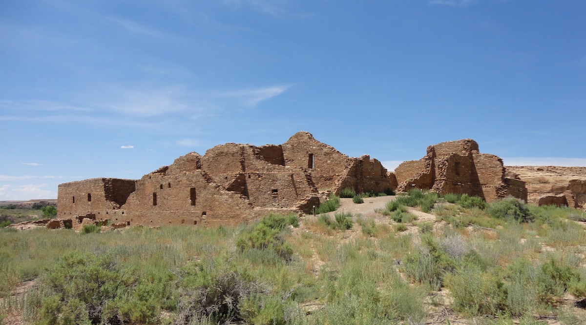
The Ancestral Puebloan great house, Pueblo del Arroyo, in Chaco Culture National Historical Park, New Mexico. Photo by Rationalobserver.

Types of evidence produced by recent studies

Prolonged megadroughts like the “Great Drought” (1276–1299) coincide with widespread abandonment of large Four Corners settlements and severe maize shortfalls.1

Tree rings and other proxies show multi‑year to multi‑decadal droughts during the broader Medieval Climate Anomaly (roughly AD 800–1300).2

Environmental degradation including deforestation and topsoil erosion around major centers like Chaco and Mesa Verde, reducing fuel and soil productivity.3

Deer bones decline and turkey bones increase after about AD 1150, suggesting overhunting of wild game and heavier reliance on domestic turkeys that competed with people for maize.4

Hydrologic stress and extreme variability: Ancestral Puebloan societies were highly dependent on winter snowpack and limited runoff; summer rains were unreliable and often arrived as intense, erosive storms.In earlier droughts (AD 150–950), people were already resorting to melting cave ice for drinking water, indicating that marginal sources became critical during dry spells.5

Climate stress resulted in conflict, and the migration of Numic‑speaking groups onto the Colorado Plateau, and rapid changes in religious and political systems.6

Crop failures undermined rain‑making rituals and institutions, social cohesion and the legitimacy of leadership likely eroded, encouraging relocation.7

In short, highly climate‑sensitive dry land agriculture, local deforestation and soil loss, and repeated multi‑year droughts combined with social pressures, all combined to make life untenable in the Mesa Verde and Chaco Canyon regions.8

Conditions in today’s American Southwest are strikingly similar.

The environmental conditions in today’s American Southwest continue to be characterized by a high-desert environment, which is defined by extreme aridity, and unpredictable precipitation patterns. In many ways this mirrors the volatile climate that challenged the Ancestral Puebloans. Much like the late 13th century—a period marked by the infamous “Great Drought”—the modern region experiences significant moisture deficits and high evaporation rates.

Farmers today contend with a bimodal precipitation cycle: winter snowpack provides the primary source of groundwater and spring runoff, while intense, localized monsoon storms in late summer offer brief but erosive bursts of rain. These erratic shifts between prolonged dry spells and sudden deluges force a reliance on micro-climates and elevation-specific planting, as the short growing season is often bracketed by late spring frosts and early autumn freezes.

Soil conditions that consist largely of alkaline, nutrient-poor substrates, are highly susceptible to erosion. In areas like the Colorado Plateau, the soil is often a mixture of sandy loams and heavy clays that lack the organic matter found in more temperate zones. These soils are prone to crusting and salinity buildup, which can inhibit seedling emergence and water infiltration.

Just as the Ancestral Puebloans utilized check dams and lithic mulching (using stones to preserve soil moisture), modern land managers must navigate these “thin” soils that offer little buffer against environmental stress. The persistence of lithic soils and wind-blown loess ensures that any successful cultivation requires sophisticated water-harvesting techniques to prevent the precious topsoil from being stripped away by the elements.

#Colorado is debating whether to incentivize data centers. Western Slope leaders ask: What about water? — The #GlenwoodSprings Post Independent

State Highway 133 crosses the Crystal River several times as it flows downstream to its confluence with the Roaring Fork River in Carbondale. Some proponents of a federal Wild & Scenic designation are pushing for a quick timeline while others want a more cautious approach. CREDIT: HEATHER SACKETT/ASPEN JOURNALISM

Click the link to read the article on the Glenwood Springs Post Independent website (Robert Tann). Here’s an excerpt:

February 27, 2026

Colorado lawmakers are asking themselves: Can they bring more data centers to the state while ensuring the power-hungry facilities don’t burden ratepayers and the environment? Dueling bills in the legislature both claim to have the answer. One would push Colorado to join the ranks of many other states that offer tax breaks to incentivize data centers — the backbone of today’s technology landscape. The other would impose more stringent regulations on the industry to protect consumers and the environment from potential harm.  As the debate unfolds, some Western Slope leaders are raising concerns over what the push for data centers could mean for their communities’ most valuable resource — water…

Researchers say a large-scale data center can use up to 5 million gallons of water per day to cool down its systems. That’s enough water to serve a town of between 10,000 and 50,000 people daily, according to reporting by the Washington Post.  If Colorado chooses to entice more of the thirsty facilities to set up shop, largely in metro areas, Western Slope leaders say that could mean more water being diverted from mountain communities in an era of severe drought…“We’ve struggled for a couple generations with the water of the Western Slope, which is where the water is in Colorado, moving eastward,” said Eagle County Commissioner Matt Scherr. “This is setting up even more fights with our Front Range friends than I think is necessary.” 

This year’s record-low snowpackgrowing drought concerns and unresolved Colorado River negotiations further punctuate that point, said Kristin Green, a water policy adviser for the Northwest Colorado Council of Governments Water Quality/Quantity Committee.

“Any kind of water use needs to be heavily scrutinized because of the dire straits we are in,” Green said. 

In which my colleagues and I share thoughts on the future of #ColoradoRiver governance — John Fleck (InkStain.net) #COriver #aridification

Colorado River “Beginnings” where the snow accumulates. Photo: Brent Gardner-Smith/Aspen Journalism

Click the link to read the article on the InkStain website (John Fleck):

February 27, 2026

It is hard to know where to begin. The Department of the Interior’s Post-2026 Colorado River draft environmental impact statement, and the deep questions it raises, is an “everything including the kitchen sink” sort of process.

But at its root, the question it raises is simple: Tell us what you’re going to do.

It is easiest to quote the Draft EIS itself on the central question: “In critically dry periods, all alternatives have unacceptable performance.” Roger that. Tell us what you’re going to do.

In the short run, with a meager snowpack and no clear explanation of how federal and state managers are going to operate the reservoir system, the basin’s dams and diversions now, we have no clear picture of what will happen in 2026. Tell us what you’re going to do.

Some specifics

The ad-hoc collective that Allen Best dubbed “the Traveling Wilburys of the Colorado River” – Anne Castle, Eric Kuhn, Jack Schmidt, Kathryn Sorensen, Rin Tara, and me – took yet another stab at offering our suggestions in comments we submitted yesterday to Interior’s P26 EIS process.

I’ve been mentally largely elsewhere lately, finishing up the book and managing my health (I’m doing great! Thanks for asking!), so I mostly show up at the last minute on these things to dub my vocals, but my friends are very kind and inclusive, and they do good work. In particular, stuff like this full of both useful NEPA-speak and also substance:

As I said: Tell us what you’re going to do.

As I said: Tell us what you’re going to do.

This one’s on you, Secretary Burgum. We do offer suggestions, but if you don’t like ours, then tell us your alternative: Tell us what you’re going to do.

This one has seemed for a long time like a no-brainer to me:

Really?

This one’s on my Upper Basin leaders: Really?

Again, Secretary Burgum: Tell us what you’re going to do.

The colossal failure of the Colorado River Basin leadership is on display in this simple sentence from the draft EIS: “In critically dry periods, all alternatives have unacceptable performance.” [ed. emphasis mine]

You’ve spent the last few years telling us what you can’t do. It’s on you now: Tell us what you’re going to do.

(Lots more in the full comments, it’s a useful primer on the current state of play.)

Map of the Colorado River drainage basin, created using USGS data. By Shannon1 Creative Commons Attribution-Share Alike 4.0