October 3, 2023 — Colorado Governor Jared Polis announced the appointment of Rebecca Mitchell, the State of Colorado’s Commissioner to the Upper Colorado River Commission, as Director of Compact Negotiations of the Interbasin Compact Committee (IBCC).
As IBCC Director, Commissioner Mitchell will directly link input from the Basin Roundtables and IBCC to the interstate Colorado River negotiations. She will also continue to engage with the Colorado Water Conservation Board (CWCB) through bimonthly IBCC Director’s Reports and Colorado River updates at CWCB meetings.
In this role, Commissioner Mitchell will chair the IBCC, a 27-member committee that includes representatives from the nine Basin Roundtables, Colorado Senate and House Agriculture Committee representatives, and six Governor appointees from geographically diverse parts of the state.
Commissioner Mitchell’s new role will strengthen and integrate water policy discussions happening across the state, the Colorado River Basin, and the American West.
“I am grateful for the opportunity,” said Commissioner Rebecca Mitchell. “As Colorado’s representative on Colorado River matters, this will provide a clear conduit for input and communication. It’s an important link for Coloradans—and it’s an important link for me, so I can continue to represent the entire state on the interstate stage.”
The Department of Natural Resources Executive Director, Dan Gibbs, will step down as the current IBCC Director. “Becky will be an amazing IBCC Director,” Director Gibbs said. “I am confident that she will bring a relationship-oriented approach to the IBCC just as she did as CWCB Director, while also bringing the IBCC’s feedback into our interstate Colorado River discussions.”
Basin roundtable boundaries
The IBCC was created in 2005 as directed by the Colorado Water for the 21st Century Act. Since then, the IBCC has provided an important, diverse, and balanced forum for policy input across Colorado and has helped shape numerous state planning initiatives through a focused discourse on the major policy challenges within and across the state and the nine Basin Roundtables. Its members provide expertise in water-related environmental, recreational, local governmental, industrial, and agricultural policy matters and it serves as a venue for consensus-building.
A double rainbow arches over the Painted Wall in Black Canyon at Gunnison National Park.
Photo Credit: Dave Showalter
From email from Reclamation (Erik Knight):
Releases from the Aspinall Unit will be decreased from 1400 cfs to 1050 cfs on Wednesday, October 4th. Releases are being decreased in response to declining inflow forecasts for the Aspinall Unit.
Flows in the lower Gunnison River are currently above the baseflow target of 1050 cfs. River flows are expected to remain above the baseflow target for the foreseeable future.
Pursuant to the Aspinall Unit Operations Record of Decision (ROD), the baseflow target in the lower Gunnison River, as measured at the Whitewater gage, will be 1050 cfs for October through December.
Currently, Gunnison Tunnel diversions are 700 cfs and flows in the Gunnison River through the Black Canyon are around 700 cfs. After this release change Gunnison Tunnel diversions will still be 700 cfs and flows in the Gunnison River through the Black Canyon will be near 350 cfs. River flows will increase next week as part of a flow request for the trout fishery survey in the Gunnison Gorge. Current flow information is obtained from provisional data that may undergo revision subsequent to review.
Early analyses show global warmth surged far above previous records in September — even further than what scientists said seemed like astonishing increases in July and August. The planet’s average temperature shattered the previous September record by more than half a degree Celsius (0.9 degrees Fahrenheit), which is the largest monthly margin ever observed. Temperatures around the world last month were at levels closer to normal for July according to separate data analyses by European and Japanese climate scientists. September’s average temperature was about 0.88 degrees Celsius (1.6 degrees Fahrenheit) above 1991-2020 levels — or about 1.7 degrees Celsius (3.2 degrees Fahrenheit) above normal from before industrialization and the widespread use of fossil fuels.
Click the link to read the article on the USBR website (Chelsea Kennedy):
Sep 28, 2023
WASHINGTON – Reclamation is awarding $11 million in federal funding to 15 projects to support the advancement of the use of snow monitoring technologies for water supply forecasting.
Reclamation’s Research and Development Office sought proposals for projects that demonstrate and/or deploy technologies in emerging snow monitoring, deploy existing snow monitoring technologies in underserved areas, or improve the use of snow monitoring data to enhance water supply forecasts.
Projects awarded include $11 million in federal funding and $6.2 million in cost share funding, totaling over $17 million in investment for snow monitoring.
Projects awarded funding include:
Applied Research Team, Inc.: Mapping Snow Water Equivalent with Weather Radar.
Colorado River Authority of Utah: Flakes, Flights, and Forecasts: Snowpack Measurement Enhancements in the Uinta Mountain Headwaters
Colorado State University:
Integrating field, remote sensing, and physics-based models to improve water supply forecasts in wildfire-impacted basins in the Western United States.
Demonstration and evaluation of a Cosmic Ray Neutron Rover as an emerging snow monitoring technology.
Hydroinnova LLC: Cosmic-ray snow gauges for monitoring snow water equivalent.
Montana State University: Emerging UAV gamma-ray and LiDAR snow observations for improved water supply modeling in the Missouri headwaters.
Mountain Hydrology LLC: Airborne Snow Surveys for Water Supply Forecasting in the Wind River Range, WY.
Northern Colorado Water Conservancy District: Watersheds through Adapting Blended SWE and Snow Albedo Products
The Desert Research Institute: Developing a Cooperative Snow Temperature Survey.
The University of Colorado:
Does integration of airborne lidar with existing snow monitoring technologies improve water supply forecasts in the western United States?
Snow water equivalent data fusion for the Western U.S. to support water resources management.
Truckee-Carson Irrigation District: Airborne Snow Observatory Driven Forecasting in the Truckee-Carson Basins.
University of Arizona: Improving Water Supply Forecasting in the Colorado Basin with 40+ years of Gridded Snowpack Data.
University of Oklahoma: Improving the skill of reservoir inflow forecasts over the Colorado River basin using high-resolution snow monitoring data and Explainable Artificial Intelligence models.
University of Wyoming: Seasonal Snow Water Supply Forecast guided by the Climatic Oscillation using the Non-Gaussian Information Metrics for the Inland Basins.
For more information on each project visit the program website. Reclamation’s Snow Water Supply Forecast Program aims to enhance snow monitoring and advance emerging technologies in snow monitoring for the benefit of water supply forecasting. The program activities stand to build climate change resilience by enabling improved water management.
Fraser River at gage below Winter Park ski area. Photo credit: Colorado Water Trust
Here’s the release from the Colorado Water Trust (Tony LaGreca and Mike Holmes):
Granby, Co., (Sept 18, 2023) – On September 18, 2023, the Grand County Irrigated Land Company (GCILC) started releasing water from Meadow Creek Reservoir to boost instream flows in the Upper Fraser River. Releases from the reservoir will be picked up by the Moffat Collection system and in exchange Denver Water will reduce diversions at the Jim Creek collection point. This will boost flows in the Upper Fraser River through the Town of Winter Park and on downstream. This project is part of a one-year agreement between GCILC and Colorado Water Trust (the Water Trust). Both parties hope it can be the first year of a longer-term solution to low flows of the Fraser River.
The added flow from the project, estimated at 3 cfs (cubic feet per second), is intended to support river health during times of low flow. The Water Trust analysis shows that flows in the reach of the Fraser River from Crooked Creek to the Town of Winter Park are regularly below the 8 cfs necessary to preserve the natural environment; and that low flows are most common in September.
To implement this project GCILC and the Water Trust obtained approval for a Water Conservation Program from the Colorado River District. This program allows GCILC to release the stored water for an environmental benefit without impacting the use records associated with those storage rights. GCILC worked with the Learning By Doing group to decide which stream reach would benefit from the project and with Denver Water to move the water through the Moffat collection system to the Upper Fraser.
“Historically the Upper Fraser River near Winter Park has seen low flows, particularly in August and September when resident trout are starting their fall spawning migration. Boosting flows at this time can help those fish have successful spawning runs and keep this valuable recreational fishery healthy. We are fortunate to have an excellent partner in GCILC and we look forward to working with them long into the future to keep the Fraser River flowing strong,” Tony LaGreca, Project Manager, Colorado Water Trust.
“By partnering with the Water Trust, GCILC hopes the releases of water from Meadow Creek Reservoir will, in a small way, help to mitigate the impacts to the watershed from the trans mountain diversions, and beconsistent with the Colorado River Cooperative Agreement,” Mike Holmes, Grand County Irrigated Land Company.
Under state statute, Water Conservation Programs can operate in 5 years out of a 10-year period. This is the first year of operation for this project. The parties plan on evaluating the success of this first year of operation before applying for future years of operation.
This is a true, broad collaboration between a local irrigation company (GCILC), a statewide Colorado nonprofit (The Water Trust), and international and national companies providing the funding to help make it all possible (The Coca-Cola Company and Swire Coca-Cola). Thanks to the financial support of the two companies, the Water Trust will reimburse the GCILC for the environmental flow releases.
ABOUT COLORADO WATER TRUST: Colorado Water Trust is a private, nonprofit organization that restores water to Colorado’s rivers by developing and implementing voluntary, water sharing agreements. Since 2001, the Water Trust has restored nearly 21 billion gallons of water to 600 miles of Colorado’s rivers and streams.
ABOUT THE COCA-COLA COMPANY: The Coca-Cola Company (NYSE: KO) is a total beverage company with products sold in more than 200 countries and territories. Our company’s purpose is to refresh the world and make a difference. We sell multiple billion-dollar brands across several beverage categories worldwide. Our portfolio of sparkling soft drink brands includes Coca-Cola, Sprite and Fanta. Our water, sports, coffee and tea brands include Dasani, Smartwater, vitaminwater, Topo Chico, BODYARMOR, Powerade, Costa, Georgia, Gold Peak and Ayataka. Our juice, value-added dairy and plant-based beverage brands include Minute Maid, Simply, Innocent, Del Valle, Fairlife and AdeS. We’re constantly transforming our portfolio, from reducing sugar in our drinks to bringing innovative new products to market. We seek to positively impact people’s lives, communities and the planet through water replenishment, packaging recycling, sustainable sourcing practices and carbon emissions reductions across our value chain. Together with our bottling partners, we employ more than 700,000 people, helping bring economic opportunity to local communities worldwide. Learn more at http://www.coca- colacompany.com and follow us on Instagram, Facebook and LinkedIn.
ABOUT SWIRE COCA-COLA: With revenues of $3 billion, Swire Coca-Cola, produces, sells and distributes Coca-Cola and other beverages in 13 states across the American West. The company’s territory includes parts of Arizona, California, Colorado, Idaho, Kansas, Nebraska, Nevada, New Mexico, Oregon, South Dakota, Utah, Washington, and Wyoming. Employing more than 7,200 associates the company’s headquarters is in Draper, Utah.
Meadow Creek Reservoir. Photo credit: Colorado Water Trust
Confluence of the Little Colorado River and the Colorado River. Climate change is affecting western streams by diminishing snowpack and accelerating evaporation. The Colorado River’s flows and reservoirs are being impacted by climate change, and environmental groups are concerned about the status of the native fish in the river. Photo credit: DMY at Hebrew Wikipedia [Public domain]
Colorado River officials plan to expand a conservation program next year that pays farmers and ranchers to use less water. But questions remain about some of the proposed ideas and the program’s overall efficacy.
The state initially launched the System Conservation Pilot Program in 2015 as a part of a multistate effort to conserve water from the Colorado River, which provides water for millions of residents throughout seven states as well as Mexico. The effort was designed to see if conservation efforts could stabilize the water levels in critical reservoirs along the river, like Lake Powell.
While there have been some challenges, the project is set to expand in 2024, Colorado Water Conservation Board Director Lauren Ris said during the National Community Reinvestment Coalition’s Just Economy conference in Denver on Sept. 27.
Some of the changes the CWCB is planning to implement include making it easier for farmers and ranchers to apply for the federally-funded program, creating a transparent pricing mechanism, and encouraging participants to recommend new technology solutions.
These new efforts could help preserve water resources for about 40 million people across multiple states in the Southwest as they face population increases and the need to build more housing. And Colorado is in a unique position to drive that change because of its status as a headwater state, Ris said.
“We really rely on water from mother nature. We don’t have the ability to draw water from somewhere else,” she added.
An unparalleled challenge
When the conservation pilot program began in 2015, concerns about the Colorado River’s declining water levels, largely due to human-caused climate change, were already well established. More than a decade of declining snowfall in the Rocky Mountains created record low water levels in Lake Powell and Lake Mead, which are two of the nation’s largest reservoirs. They also provide water and hydroelectric power to millions of Americans.
To address the issue, Colorado spent about $8.5 million to conserve 47,200 acre-feet of water between 2015 and 2018, according to data shared about the pilot program during the CWCB’s board meeting on Sept. 21. That’s roughly $180 per acre-foot. One acre-foot can support up to two households for a year.
But then the program went dark until 2022 when water levels in the Colorado River reached historic lows. The federal government initially asked several Western states including Colorado to reduce their water consumption by up to 4 million acre-feet per year before deciding to allow the states to work out their own agreement.
From left, New Mexico Community Capital’s Jeff Atencio, Central Arizona Water Conservation Board’s Ylenia Aguilar, Colorado Water Conservation Board’s Lauren Ris, and CPR’s Michael Sakas prepare for a panel on the Colorado River at the National Community Reinvestment Coalition’s Just Economy conference in Denver on Sept. 27, 2023. (Robert Davis for Colorado Newsline)
By June 2022, the four … Upper Basin states — Colorado, New Mexico, Utah and Wyoming—had put together a five-point water conservation plan. The first point of the plan was to restart the SCPP.
In December, the federal government reauthorized the program and allocated up to $125 million from the Inflation Reduction Act for the Upper Basin states to spend on water conservation efforts between 2023 and 2026.
As of this month, the SCPP has supported 64 projects across the Upper Basin states and conserved about 38,000 acre-feet of water, Amy Ostidek, the water conservation board’s interstate, federal, and water section chief, said during the Sept. 21 meeting. Twenty-two of those projects were in Colorado and they conserved a total of roughly 2,500 acre-feet of water.
Conserving the future
But the program’s re-launch wasn’t as smooth as many had hoped, Ostidek lamented.
“Getting things kicked-off in December just wasn’t tenable for water users trying to make decisions about their operations,” Ostidek said. “And, frankly, that put all of us in a crunch to do things very quickly, and maybe not as well as they could have been done if we had more time.”
To address these issues, the SCPP will open applications for the 2024 program starting in October. Ris said this will help provide some “operational certainty” for water users.
Another aspect that will be revised is the pricing mechanism. This year’s SCPP is paying ranchers and farmers about $150 per acre-foot of water saved, which was based on the median payments allocated under the pilot program, The Colorado Sun reported. However, ranchers and farmers have been getting paid nearly $394 per acre-foot on average.
The program is also looking to incorporate more technology to address data and efficiency gaps in the system. Some target areas include creating drought-resilience tools and implementing conservation strategies that address the needs of rural communities along the lower Colorado River Basin, like in northern Arizona.
“At the end of the day, the people who are most impacted by these decisions are often the most vulnerable members of our communities and the most underserved,” Central Arizona Water Conservation Board member Ylenia Aguilar said.
Chatfield Reservoir is among those statewide that are reaching highs not seen in three years. Credit: Mitch Tobin, Water Desk, LightHawk aerial photography
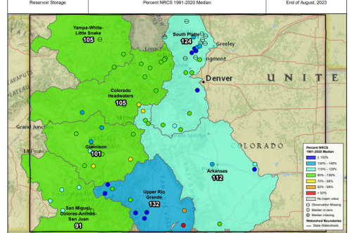
Thanks to an exceptional year of deep winter snows and frequent summer rains, Colorado’s drought-stricken reservoirs have reached a three-year high, with the statewide average standing at 102% of normal, up from 78% at this time last year.
“Statewide [reservoir levels] increased to above normal for the first time in three years,” said Karl Wetlaufer, a hydrologist and assistant snow survey supervisor for the Natural Resources Conservation Service (NRCS) in Lakewood. “We’ve seen really significant increases in every individual river basin as well as statewide.”
Wetlaufer’s comments came last week at a meeting of the state’s Water Availability Task Force, which monitors rain and snow, weather forecasts, and stream and soil conditions statewide. Wetlaufer is a member of the task force.
The numbers don’t mean all the state’s reservoirs are full, but that their “fullness” at this time is above average for this time of year. Reservoirs are tracked in each of Colorado’s eight major river basins, with the South Platte and Arkansas basins seeing the biggest gains, Wetlaufer said.
Colorado derives the majority of its drinking and farm water supplies from mountain snows that are collected in reservoirs, and as a result, reservoir levels are closely watched.
Colorado reservoirs have reached their highest levels in three years, with the statewide average reaching 102% of normal, according to the Natural Resources Conservation Service.
Hydrologists track water throughout a period of time known as the water year, which begins Oct. 1 and ends Sept. 30.
Water year 2023 has given Colorado and other Western states a major reprieve from a 22-plus-year drought cycle that is considered the worst in more than 1,200 years. Precipitation registered at 108% of normal.
The year “has been wetter than average for a lot of areas around the state,” said Becky Bolinger, assistant state climatologist at Colorado State University’s Climate Center who is also a member of the task force.
This year is giving the whole state a much-needed leg up on moisture going into the winter.
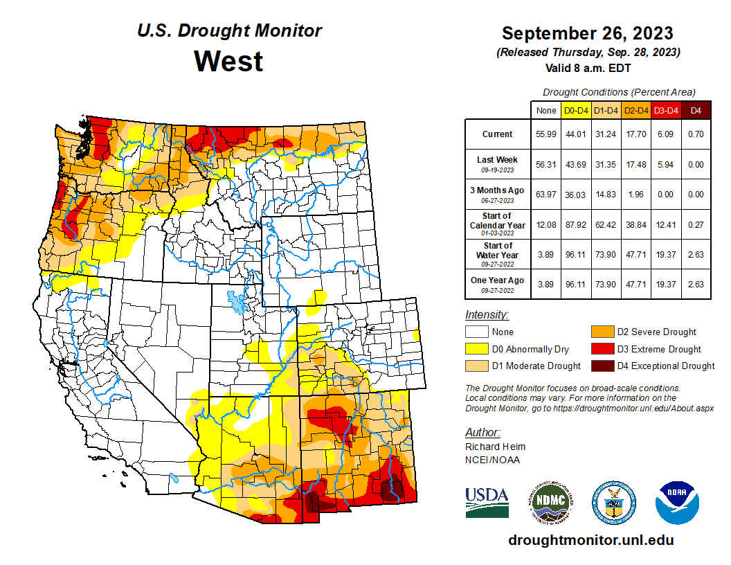
West Drought Monitor map September 26, 2023.
This doesn’t mean that the megadrought is over, though for a two-week period in July, the state was actually drought free, Bolinger said. But since then low levels of drought have returned to the southwest and south-central part of the state, including the San Luis Valley, where Alamosa had its driest summer on record, receiving just 4.32 inches of rain, down from a norm of 7.5 to 8 inches.
Looking ahead, the water picture remains healthy. An El Niño weather pattern that is expected to arrive shortly and continue into the winter and next spring will bring with it wet snows for much of Colorado, with the exception of the northwest mountains.
That same weather pattern means the danger of ultra-dry conditions returning in the next six months is slim, Bolinger said.
“Overall I am not seeing any indicators over the next six months that things are going to turn bad, but in the next year a lot will change. The area I will probably watch is the northern mountains. That is an area that could be at risk for developing drought,” she said.
Still water utilities, coming off a summer when rains kept lawn sprinklers turned down and helped bolster those reservoir levels, are pleased with the situation.
“The South Platte Basin has had a really good summer which translates into lower demand on our system,” said Swithin Dick, water resources administrator for the Centennial Water and Sanitation District in Highlands Ranch. “It’s looking good going into the winter.”
Grand opening of the Gunnison Tunnel in Colorado 1909. Photo credit USBR.
From email from Reclamation (Erik Knight):
Releases from the Aspinall Unit will be decreased from 1750 cfs to 1400 cfs on Monday, October 2nd. Releases are being decreased in response to a reduction in diversions at the Gunnison Tunnel.
Flows in the lower Gunnison River are currently above the baseflow target of 1050 cfs. River flows are expected to remain above the baseflow target for the foreseeable future.
Pursuant to the Aspinall Unit Operations Record of Decision (ROD), the baseflow target in the lower Gunnison River, as measured at the Whitewater gage, will be 1050 cfs for October through December.
Currently, Gunnison Tunnel diversions are 1050 cfs and flows in the Gunnison River through the Black Canyon are around 700 cfs. After this release change Gunnison Tunnel diversions will be 700 cfs and flows in the Gunnison River through the Black Canyon will still be near 700 cfs. Current flow information is obtained from provisional data that may undergo revision subsequent to review.
Xcel Energy building in downtown Denver. Photo credit: Allen Best/Big Pivots
Click the link to read the article on the Big Pivots website (Allen Best):
A lot of money, of course, and a lot of new transmission in and around metropolitan Denver. What else is there in this package?
What an exciting time for Colorado.
We’re reinventing energy at a brisk pace that puts us in the front tier of states engaged — and also guiding — this necessary and critical transition.
And now we have specifics of what our largest electrical utility, Xcel Energy, with 1.6 million customers, prefers to do in meeting expanding demands for electricity while complying with a raft of state laws adopted beginning in 2019.
“This plan is transformational,” says Xcel in its filing from Monday night with the Colorado Public Utilities Commission. Yep.
You can download the report, “Our Energy Future: Destination 2030” Or go to the PUC e-files in proceeding 21A-0141E and look for Public 2021 ERP & DCEP.. There are several dozen related documents in the docket.
You’ve probably read the about this in the Denver Post or elsewhere. Lots of statistics. The most important one in 184 pages of statistics is this:
Xcel expects to be at 80% to 85% emissions-free energy by 2030. That not just a reduction as compared to 2005 levels. The law adopted in 2019 required it to achieve 80% reduction. This plan, if adopted and executed, goes higher. This is more than reduction. It goes roughly 10% higher.
The company says it can deliver this with a rate impact of about 2.25% annually. This compares with the projected rate of inflation of 2.3% during the remainder of the 2020s.
Too much? Well, Xcel does look out after its own financial interests. Robert Kenney, the president of Xcel’s Colorado division, made the case for reward for capital invested in an exchange Tuesday night with self-appointed and dedicated Xcel watchdog Leslie Glustrom at Empower Hour.
“I do believe we have seen the investor-owned utilities (around the country) spur innovation for nascent technologies into maturity,” said Kenney, who before his arrival in Colorado in June 2022 spent seven years with PG&E in California and, before that, as a PUC commissioner in Missouri for six years.
Xcel is moving boldly with the $14 billion in energy investments identified in this plan, but it may not even be the most impressive feat in Colorado. Holy Cross still says it expects to be at 100% emissions-free energy by 2030. And Tri-State, too long the epitome of a drag-your-feet G&T, is not terribly far behind — if it can keep its members. But that’s another story.
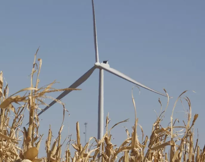
Xcel was reluctant to go forward with its first major wind farm, completed in 2004, but now has much wind — and will add far more in the next few yeas. Photo near Cheyenne Wells, Allen Best
Keep in mind, this is not just fuel switching. It’s also fuel expansion. We will need double or triple the electricity as we electrify buildings and transportation. We’ve barely begun.
This is on top of population expansion within metro Denver, the primary market for Xcel Energy. Xcel projects increased demand (called load, in the terminology of electrical providers) at 300 megawatts by 2026.
Xcel’s report notes that the population growth in the Denver metro area has consistently outpaced the national rate in every decade since the 1930s.
That said, much in Xcel’s preferred plan was unsurprising. It lays out a broad program for 6,545 megawatts of new renewable projects, broken down in this way:
3,400 megawatts for wind;
1,100 megawatts of solar;
1,400 megawatts of solar combined with storage;
19 megawatts of biomass (forest trees at a plant in Hayden);
600 megawatts of standalone storage.
And to think, aside from the 340-megawatt Cabin Creek pumped-storage hydro at Georgetown, Colorado’s largest battery storage facility last winter was still only 5 megawatt-hours (at the Holy Cross project between Glenwood Springs and Basalt).
This year, Xcel has added 225 megawatts of battery storage to Front Range locations. That was the result of a 2016 resource plan. These things do take time.
Xcel said it proposes six times more storage as compared to its contemplation earlier in this process — a result directly of incentives provided by the Inflation Reduction Act of 2022.
That federal package also delivers other benefits. It will, says Xcel, bring “billions of dollars in federal support to Colorado.” It estimates $10 billion in IRA benefits to customers.
Big investment in transmission
Transmission figures prominently in this plan.
PUC commissioners last fall approved the Power Pathway Project, a $1.7 billion string of high-voltage transmission lines looping 560 miles from near the Pawnee power plant at Brush and around the eastern plains and back to the Front Range. Construction began in June.
Xcel says its “existing transmission system is capable of reliably serving our customers today, but the energy transition cannot be accomplished with only minor changes to the transmission system.”
This plan proposes an additional $2.82 billion in transmission investments.
Part of that is the May Valley-Longhorn extension from the May Valley substation north of Lamar to Baca County, in the state’s southeastern corner. The 50-mile extension, called Longhorn — as most everything is called in the Springfield area — would cost $252 million. It figures prominently in Xcel’s plans because, as this report explains, Xcel finds the wind to be of low cost and its characteristics complementary to wind in other locations.
“Wind generation in the southeast portion of Colorado exhibits materially different generation patterns and will thus be a useful improvement to our system in adding geographic diversity to our overall renewable generation portfolio.”
Or, to paraphrase what I heard from locals in a visit there last week: the wind always blows in Baca County. They can describe the different winds with the expertise that a wine connoisseur might apply to various vintages.
Xcel says the Longhorn transmission extension will deliver 1,206 megawatts of wind. It also says that this wind will save the company – and hence consumers – a great deal of money: $282 million.
That deserves a wow!
However, if that Baca County wind were excluded, there would be more solar and storage.
The San Luis Valley also stands to get transmission upgrades. Appendix Q in the filings says this:
“The area has rough, remote, and challenging geography and weather, significant permitting issues due to a patch work of state and federal land use designations (conservation easements, U.S. Forest Service-managed land, National Park Service managed lands, and multiple state-protected areas).”
Electrical deliveries arrive almost entirely via three transmission lines crossing Poncha Pass. The valley residents are served by both Xcel and by Tri-State members. Both utilities have tried to create solutions since a 1998 study identified the problems. Some Band-Aids have helped.
Xcel proposes to spend $176 million to improve the situation in the San Luis Valley. Additional transmission would also open the door to development of new solar.
Most surprising to me — likely because I do not read the filings on the PUC dockets religiously – is how much Xcel believes it needs to spend in metro Denver: $2.146 billion.
It justifies the expense with this explanation.
“The company’s analysis shows that a new phase of the transition is emerging – reliably managing power transmission within and around the metropolitan area,” says the report. (Page 33).
“Delivery of remote resources is still an important consideration of transmission planning, as evidenced by the critical role that the CPP (Colorado Power Pathway) plays in enabling the preferred plan. However, as the company moves toward a grid powered primarily by renewable resources, and less reliant on legacy urban power plants, transmission investments are increasingly focused on enhancing the capacity and resiliency of the entire transmission grid —including those parts of the grid located closest to our customers’ homes and businesses.”
Why so much money for transmission upgrades in metro Denver? In part, says Xcel, it’s because of the lack of bids for resources within the metro area. The report and an accompanying appendix do not discuss reasons why the company failed to get those close-in resources.
That takes us to natural gas —and the related issue of how well Xcel can meet peak demands caused by extreme weather. The environmental community has been insistent that Xcel needs to reduce or eliminate its investment in natural gas generation. Xcel has maintained that natural gas must remain part of the equation, at least in this planning period, because alternatives have not yet been firmed up.
The company proposes to have 628 megawatts of capacity. This, it says, will solve the “reliability and resiliency variables” of a hot period in the summer of 2028.
In short, Xcel has to prepare for hot summers and cold winters. The base case is a hot spell in July 2022 and Winter Storm Uri of 2021. At both times, renewables underperformed. (I might have thought reference cases to a much hotter time of the future would have been used, but maybe I’m missing something).
What enables Xcel to meet the peak demands for cooling or heating? It could add on even more proven storage, altogether 3,700 megawatts worth, and over 13,000 megawatts of renewables, but at a cost of $5.4 billion more than this plan.
Instead, Xcel sees natural gas being the answer. The company emphasizes modeling that shows the new 400 megawatts of natural gas-created electricity will be needed only 5% of the time. Most of the time, they will sit idle. But, when needed, some can ramp up in a matter of 2 to 10 minutes, others as long as 30 minutes. This compares with coal plants, which mostly took 18 hours to ramp up.
Xcel is proposing a reserve margin of 18%. That’s how much capacity it plans on top of what it thinks it needs. All utilities have some reserve margins.
Game changers in next few years?
Storage is a major component of this part of this Xcel pivot and energy transition story altogether.
“The availability of cost-competitive utility-scale storage is reducing, but not eliminating, the need for new carbon emitting capacity resources – namely in inclement weather and during long-duration high-load situations,” says Xcel.
Will we get a break-through that will change the narrative?
Xcel plans a demonstration project at Pueblo that it expects to get underway in late 2024 to test the efficacy of a new storage technology called iron-rust that the developers believe can store energy for up to 100 hours. Along with its partner, Form Energy, it received a $20 million grant in April from the Breakthrough Energy Catalyst. This week, Xcel announced a grant of up to $70 million from the U.S. Department of Energy. Both grants are to be split between the Pueblo project and a parallel project in Minnesota.
If this proves out, does this change the ball game, largely eliminating the need for natural gas?
Xcel nods at this question, pointing to modeling results that “Highlighting the need for further advancements in technology and a more diverse portfolio of resources may be needed to help economically reach our clean energy goals in the future.”
It also talks about using fuels other than natural gas – think hydrogen and ammonia and biogas —in these plans.
This natural gas component will be the most hotly disputed element of the Xcel plan—as it has been for the last two years.
Also raising my eyebrows in this 120-day report:
New technologies
A recent Colorado law sought to nudge utilities into accelerating new technology. The rule-making by the PUC in regard to this Section 123 provision specified that the resources must be “new, innovative, and not commercialized technology, and provide unique, scalable and beneficiation attributes as to future costs, emissions, reduction, or reliability benefits.” “Wind, solar or lithium-ion based battery storage,” concluded the PUC, do not qualify.
Xcel solicited bids and got a variety of proposals, including:
a plant in the San Luis Valley that could burn a variety of clean fuels including hydrogen and ammonia;
a hydrogen fuel cell project near Brush that would use salt-storage caverns to deliver 10-hour storage;
a 5-megawatt geothermal power plant in Weld County that would mine the 135 degree C (275 degrees F) non-potable water found deep underground.
Xcel found all of these proposals from bidders wanting for one reason or another. However, that’s not a solid no in all the cases, the company added.
Xcel Energy proposes a small biomass at Hayden, site of the current Hayden Generating Station. It says skill sets can transition relatively easily. Photo/Allen Best
Biomass at Hayden
The company proposes a 19-megawatt biomass plant at Hayden, burning dead trees from northwest Colorado to produce electricity. Colorado has an existing biomass plant at Gypsum, which is a little smaller, 11.5 megawatts, in capacity. It burns wood from as far away as the Blue River Valley between Silverthorne and Kremmling.
Workforce transition
The company points out that it has closed 18 generating units across its service territory during the last 15 years without any forced workforce reductions.
It says it will leverage natural attrition and worker retirements, and the remaining workers will be “up-skilled to operate and maintain the new clean energy assets or, if they choose, relocated and or transited and reskilled into another job.”
For example, it says, workers at the Hayden coal-burning plant have 80% of the skills, on average, needed to operate and maintain a biomass unit. The company says it will work with the biomass unit vendor, Colorado Northwestern Community College, and others to identify the additional training needed.
Pueblo solicitation
As part of its plans for Pueblo, where the Comanche 3 coal-burning plant is scheduled for retirement by 2031, Xcel plans to solicit bids that will fill out what the company needs in that final segment of 2028-2030.
The projects need to help out Pueblo County economically, even though Xcel has already committed to paying taxes on Comanche 3 in lieu of its operation until 2040.
Will it be nuclear? Xcel has not ruled out nuclear, but neither does it see nuclear as an option for 2030.
Xcel Energy Colorado’s CEO Kenney, in his remarks at Empower Hour, said the company sees small modular reactors and related technology under development as having promise.” But, he added, “It is unlikely such technologies will be trued up on a timeline to replace Comanche 3. But it will absolutely be a technology that we will continue to explore.”
Social cost of carbon
The planning considerations for this are so much more complex than those of the past. Decisions must be filtered through the social cost of carbon and also the social cost of methane. There are considerations about disproportionately impacted communities. And, as noted above, we have “just transition” as a consideration.
The simile of a triathlon race
Such documents are not ordinarily noted for their literary flourishes, and this one is no exception. But it must be noticed that aa simile found on page 62 is worth calling out:
“Getting to this point is like training to get to the starting line of a triathlon. We are excited, we have a support team at the ready, we understand the challenges, and we are looking forward to taking them on with a good plan in place. But that does not mean that implementation and execution of the plan will be easy, and unknown challenges lie ahead given the breadth of generation and transmission development contemplated by this plan.”
Colorado Green, located between Springfield and Lamar, was Colorado’s first, large wind farm. Photo/Allen Best
At the Board of County Commisioners work session earlier that day, County Attorney Todd Weaver explained that Archuleta County was approached by a coali- tion of counties about contributing $1,000 for the conservation of the Rio Grande trout, Rio Grande chub and Rio Grande sucker in the Rio Grande watershed. He noted that the coalition represents local interests in efforts to enhance the environment for these fish with the goal of preventing them from becoming threatened or endangered, which Weaver stated would trigger a variety of requirements and restrictions.
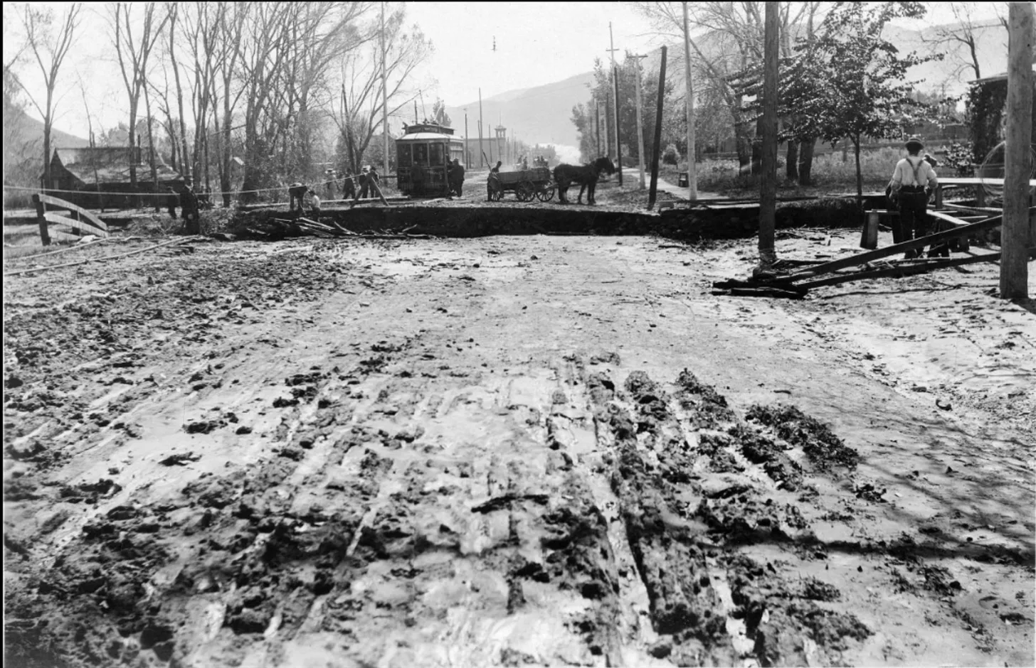
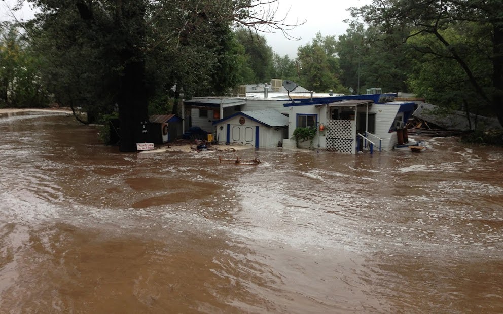
Flood damage wrought by Junction Creek in October 1911. This is looking south down Main Avenue from around the current location of Durango High School.
Click the link to read the article on The Land Desk website (Jonathan P. Thompson):
At around four a.m. on October 6, 1911, Navajo Methodist Mission Superintendent J.N. Simmons woke up to find himself and the mission near Farmington, New Mexico, surrounded by water. It wasn’t a total surprise. He and two other staffers—Frank B. Tice and Walter Weston—had received the flood alarm the previous day, but had chosen to stay, certain that the San Juan River’s waters would never reach them, and if they did, the brand new, three-story cement-block mission building, watched over by God, would provide an unsinkable refuge. They were wrong.1.
The rain began in the San Juan Mountains late on the morning of October 4, 1911. It came down gently at first, slowly gaining intensity over the course of the day. By evening the tropical storm was a torrent, dropping two inches of precipitation on Durango in just 12 hours, nearly twice what the town normally gets during all of October. Weather watchers in Gladstone, above Silverton, recorded eight inches of rain on October 5—a virtual high country hurricane.
Design for the whitewater park at Smelter Rapids via the City of Durango
Once-gurgling streams jumped from their banks and twisted steel railroad tracks into contorted sculpture, decimated roads and bridges, and demolished barns. Junction Creek tore out the Main Avenue and railroad bridges before adding its load to the Animas, which carried an estimated 25,000 cubic feet per second of water as it ran through town. It’s an almost incomprehensible volume. A good spring runoff these days might lift the waters to 6,000 cfs, high enough for the river to leave its banks and spread across the floor of the Animas Valley, and to turn Smelter Rapid into a churning hellhole for rafters.
The water unmoored the railroad bridge near Durango’s fish hatchery and carried it downstream, despite the fact that two full coal cars had been parked on the bridge to provide ballast. The river jumped its channel and headed onto 15th street, creating a five-foot-deep river that today would go right through a Burger King. further downriver the waters washed away 100 tons of toxic slag from the Durango smelter, and carried away several homes from Santa Rita, on the opposite shore.
The Animas River rushing beneath the Main Avenue bridge in Durango, Oct. 1911. Note the partially submerged house located about where the VFW is now and the water crossing Main near where Burger King is currently located. Photo credit Center of Southwest Studies, Fort Lewis College.
Sixty miles east of Durango, in Pagosa Springs, the upper San Juan River swept away more than 20 structures and destroyed the town water plant, hospital, and jail. Its power plant “was wiped out of existence, nothing left but the water wheel.” The Bayfield Blade called Arboles, a village near the junction of the San Juan and Piedra Rivers, “a thing of the past.” That was a bit of hyperbole, but maybe also prophetic: the community survived that flood, but was later buried under the waters of Navajo Reservoir. Further east the Rio Grande grew even grander and threatened to carry parts of Española, Bernalillo, and Albuquerque down to the Gulf of Mexico.
Over in Dolores, Colorado, the river peaked out at 10,000 cfs, more than 20% greater than the second highest peak hit in 1949. The raging river of sorrow ripped out railroad tracks, washed out roads, and inundated the town under four feet of water and four inches of mud, carrying away houses and the boardwalk. My great grandfather, John Malcolm Nelson, had come down from Ouray in early October to look at buying land in the Ute Strip — and he did, down at Sunnyside Mesa. But his trip back north was delayed by the fact that every bridge and road in the region was washed out.
In Farmington the seething monsters of the upper San Juan and the Animas joined forces, spilling over the banks and onto the flats on either side of the river, where the Navajo mission sat. Simmons and his fellow staffers sent the children to higher ground at about midnight as a precaution, equipping each with a blanket and loaf of bread. Then they went to bed, not realizing their own mistake until they awoke four hours later.
Somehow, Weston was able to quickly escape on horseback (he may have snuck out earlier). Tice chose to stick around, heading for the top floor of the structure. Simmons ran out and climbed atop an outhouse, apparently in order to launch himself onto a horse. Simmons missed the horse and ended up in the water, instead, carried rapidly downstream alongside dead animals, haystacks, and pieces of people’s homes.
Tice, it seemed, was the only survivor, and as the sun came up, onlookers gathered on the opposite shore. They watched Tice climb from the second story to the third, finally climbing onto the roof with his dog. It seemed safe enough; the water stopped rising after it inundated the third story. Little did he know, the waters were slowly dissolving the building underneath him, and it, the roof, the dog, and finally Tice were all swallowed up by the current.
The Shiprock Indian School campus was covered with water five feet deep, washing away several adobe buildings, and the fairgrounds, prettied up for the annual fair, were covered with a torrent of muddy water. Every bridge in San Juan County, Utah, where a miniature oil boom was on, was torn loose and carried away by the angry torrent; 150,000 cubic feet of water shot past the little town of Mexican Hat every second, according to a 2001 USGS paleo-flood hydrology investigation. That’s about 100 times the volume of water in the river during a typical March or April, a popular time to raft that section. It took out the then-new Goodridge bridge — some 39 feet above the river’s normal surface — tore through the Goosenecks, backed up in Grand Gulch, deposited trees on sandstone benches high above where the river normally flows, and finally combined with the raging Colorado River to create a liquid leviathan of unknown volume that wreaked more havoc through the Grand Canyon and beyond.
***
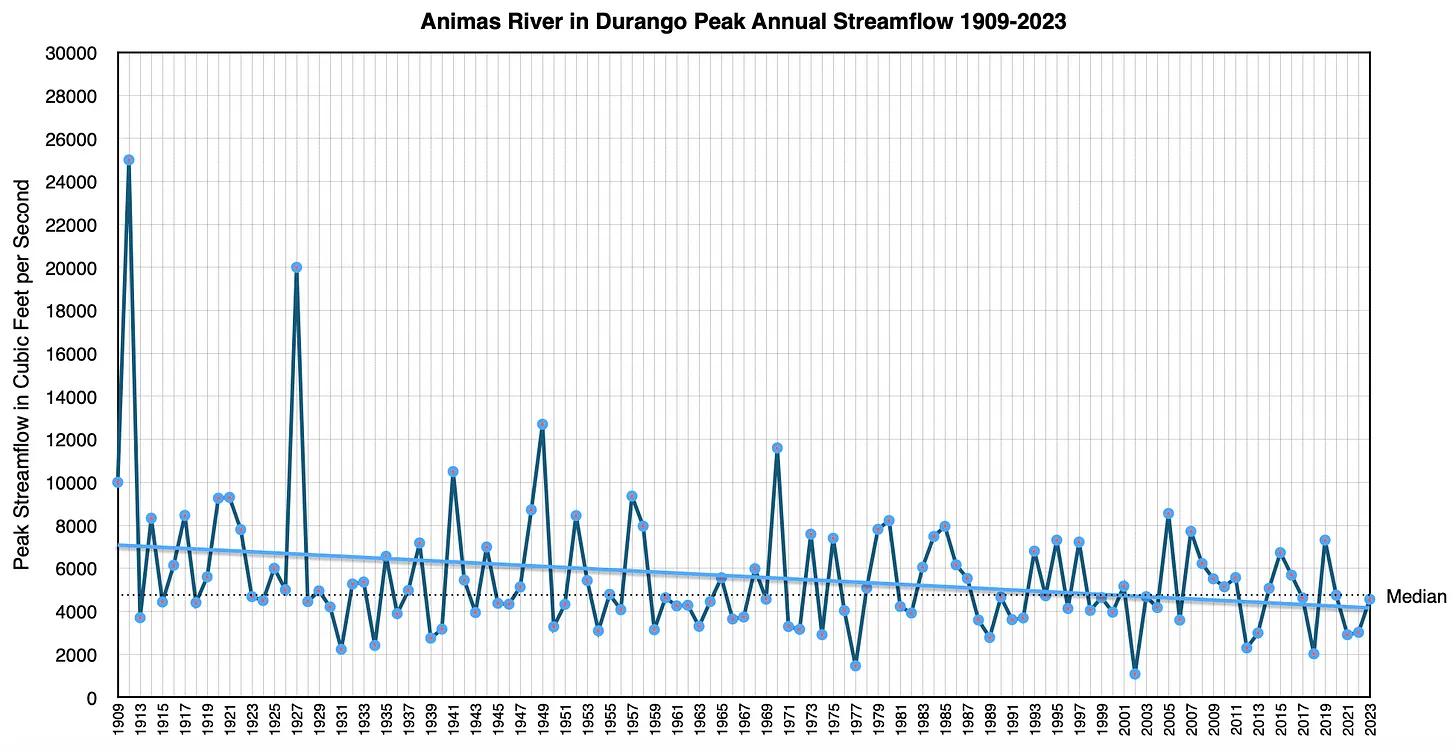
The 1911 event is typically considered to be the Four Corners Country’s biggest flood, based on streamflow estimates, anecdotal accounts, and the damage wrought. Since then it has been rivaled only by the June 1927 flood, when the Animas River in Durango reached 20,000 cubic feet per second; and in 1949 and 1970 when the high-water mark was about 12,000 cfs and 11,600 cfs, respectively. That might make 1911 seem like a freak event — a once-in-a-millennium confluence of factors. Combine that with the fact that the river’s annual peak streamflows have trended downward over the last century or so, and a 1911 repeat seems less and less likely.
But these waters are muddied, so to speak, by the relatively short timeline and limited geographical scope we’re working with. Many streams didn’t have gages on them at the time, and even those that were present weren’t always accurate (most of the 1911 figures are estimates, not actual measurements). Even though most of the “old-timers” said it was the biggest flood they’d ever seen or heard of in these parts, we have to remember that they tended to be white guys, and white settler-colonists had only been in the area for four decades or so. Not that memories of weather events are ever all that reliable.
A swollen San Juan River nearly wiped Montezuma Creek and Bluff City, Utah, off the map back in 1884 (the 1911 flood wreaked less destruction). Yet there were virtually no stream gages, so the magnitude of that earlier event is hard to quantify and, besides, maybe the later flood was less destructive because there were fewer homes and infrastructure in the flood’s path by then.
Also, when one looks beyond the San Juan Basin watershed, one finds streamflows that far exceed those of October 1911. On the USGS stream gage on the Green River in Green River, Utah, the 1911 flood (which was at the beginning of the 1912 water year, by the way) ranks as just the 5th largest flow since 1895. And 1911 places fourth overall on the Rio Grande at Otowi Bridge, outdone by 1920, 1941, and 1904.
We can extend the timeline dramatically by turning to paleoflood hydrology, which is sort of like dendrochronology, except instead of looking at tree rings to understand past climate, it uses geological evidence — slackwater lines, debris — to reconstruct the magnitude and frequency of past floods. I skimmed the available literature, including this Bureau of Reclamation survey of studies, and here’s what stood out:
The 1911 flood was likely the largest on the Animas River over the last several hundred years or more. On the San Juan River near Bluff, researchers found no evidence of floods higher than the 1911 debris, indicating it “may represent the largest flood on the San Juan River for a much longer time period than 1880-2001.” In any event, 1911 was larger than the 1884 flood, even in Bluff.
On the Colorado River at Lees Ferry the 1884 flood was most likely the largest during white settler-colonial times, with an estimated flow of about 300,000 cubic feet per second (there were no gages there, yet), which would have provided quite the ride through the Grand Canyon. Some researchers believe an 1862 flood had a flow of about 400,000 cfs. Holy big water, Batman!
Extend the timeline further and the ride gets even wilder: A 1994 USGS paleoflood study found evidence of a 500,000 cfs flood at Lees Ferry between 350 and 750 A.D.; and a 2018 reconnaissance found slackwater deposits indicating a flow of 700,000 cfs. I’m sure it provided quite the scene for Puebloan observers looking down from the canyon rim. If you happened to be in the canyon at that time? Yikes.
From: “A 4500 Year Record of Large Floods on the Colorado River in the Grand Canyon, Arizona,” by Jim O’Connor et al.
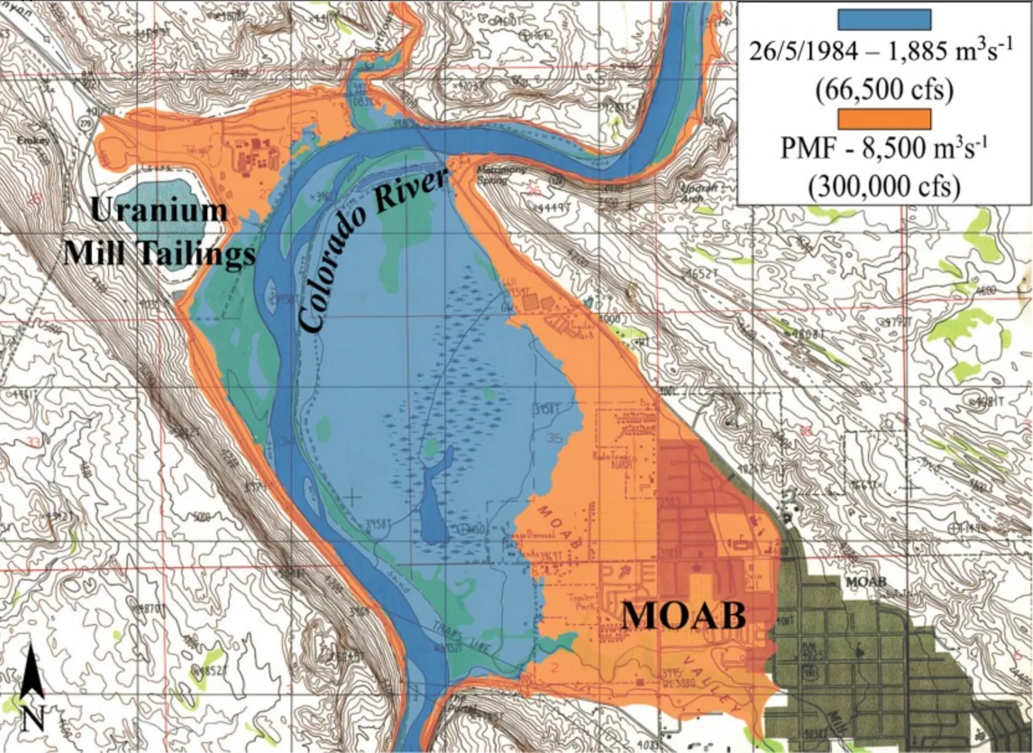
A study of floods on the Colorado near Moab found that, as is the case on the Animas River, there were a lot of large floods between the 1880s and 1930s, but peak streamflows have followed a decreasing trend ever since. One study suggested this resulted from: land-use changes, particularly a severe reduction in grazing after 1932; greater regulation of the river by upstream dams and so forth; greater upstream water consumption; and a decrease in intense, large flood-producing storms.
The Colorado River near Moab has experienced 44 floods during the last two millennia with flows ranging from 63,500 cfs to 325,000 cfs. (For context, the 1983 runoff, which threatened Glen Canyon Dam, reached 62,000 cfs on this stretch of river and in 1984 it hit 70,300). Most of those floods occurred during the last 500 years.
From “A 2000 year natural record of magnitudes and frequencies for the largest Upper Colorado River floods near Moab, Utah” by Greenbaum et al.
Warming temperatures, like those resulting from human-wreaked, fossil fuel burning-exacerbated climate change, can increase the intensity of storms and the amount of precipitation. That could, potentially, lead to bigger floods. So even though climate change has mostly manifested as drought in the Four Corners Country, it could also have the effect of putting a 1911-like storm on steroids. And with El Niño brewing in the Pacific, we might see some whopper storms sooner rather than later. Or not. Either way, though, it seems silly to assume the 1911 flood won’t repeat someday. Maybe next time it will be even worse.
That 1911 storm dissipated over the next couple of days, leaving a bright sun to illuminate the river valleys, newly scoured of the roads, houses, bridges, railroad tracks, and other detritus that humans had littered the valleys with over the previous decades. But the folks of the San Juan Basin soon went to work rebuilding — quite often in exactly the same spots that had flooded so catastrophically.
I used to see that as a combination of foolishness, hubris, obliviousness, and stubbornness all woven into a tapestry of denial. Surely they couldn’t have believed a flood of that magnitude would never occur again.
Looking from Main Avenue in Durango (or thereabouts) toward the Day House. The Animas Brewing Co. now stands about where the right, foreground house is.
And yet, now that I’ve fallen victim to a flood, or at least my home has, I finally get it. What do I know about their circumstances? Maybe they had invested everything they owned into this little plot of land and a home, and they have nowhere else to go. Maybe they are just so wedded to this particular place that they figure it’s worth the risk to build in a 100-year flood plain. Maybe they were just tenacious bastards shaking their fist at the sky in defiance.
What I do know is that if and when there is a repeat of the 1911 flood, or that whopper that sent 700,000 cfs into the Grand Canyon, it will leave some serious destruction in its wake.
The 1911 flood wrecked a lot of infrastructure, but the human death toll was much smaller than one might have expected. Among the handful of fatalities was Frank B. Tice, of the Navajo Methodist Mission, whose body was found 20 miles downstream from where he was swept away.
But there was something else, too. On an island in the San Juan River, somewhere between Farmington and Shiprock, a man huddled next to a small fire, cooking apples that he had snagged as they bobbed past. After falling in the water he had grabbed ahold of some debris, and it had carried him for miles until he finally reached the island, cold, wet and hungry but, maybe miraculously, alive. It was J.N. Simmons, of the Navajo mission.1
A 1998 paleo-flood investigation determined the measurement was in error and it was more likely that about four inches fell across a wider area. In any event, the author of the report does not dispute the magnitude of the flood that resulted.
San Juan River Basin. Graphic credit Wikipedia.Dolores River watershed
Green River Basin
Map of the Rio Grande watershed. Graphic credit: WikiMediaMap of the Colorado River drainage basin, created using USGS data. By Shannon1 Creative Commons Attribution-Share Alike 4.0
According to the findings of a new study, AMPs were detected in cloud water samples from mountain summits in Japan, which confirms that they play a key role in rapid cloud formation. Credit: Hiroshi Okochi from Waseda University
Researchers from Japan examine the presence of microplastics in cloud water and their contribution to climate change
Plastic waste that accumulates on land eventually ends up in the ocean as microplastics. However, it is now speculated that microplastics are also present in the atmosphere, contained in clouds. In a new study, researchers analyzed cloud water samples from high-altitude mountains in Japan to ascertain the amount of microplastics in them. They also shed light on how these airborne particles influence cloud formation and their negative impact on the climate.
Plastic particles less than 5 mm in size are called “microplastics.” These tiny bits of plastic are often found in industrial effluents, or form from the degradation of bulkier plastic waste. Research shows that large amounts of microplastics are ingested or inhaled by humans and animals alike and have been detected in multiple organs such as lung, heart, blood, placenta, and feces. Ten million tons of these plastic bits end up in the ocean, released with the ocean spray, and find their way into the atmosphere. This implies that microplastics may have become an essential component of clouds, contaminating nearly everything we eat and drink via “plastic rainfall.” While most studies on microplastics have focused on aquatic ecosystems, few have looked into their impact on cloud formation and climate change as “airborne particles.”
In a new study led by Hiroshi Okochi, Professor at Waseda University, a group of Japanese researchers has explored the path of airborne microplastics (AMPs) as they circulate in the biosphere, adversely impacting human health, and the climate. Their study was recently published in the journal Environmental Chemistry Letters with contributions from co-authors Yize Wang from Waseda University and Yasuhiro Niida from PerkinElmer Japan Co. Ltd. “Microplastics in the free troposphere are transported and contribute to global pollution. If the issue of ‘plastic air pollution’ is not addressed proactively, climate change and ecological risks may become a reality, causing irreversible and serious environmental damage in the future,” explains Okochi.
To investigate the role of these tiny plastic particles in the troposphere and the atmospheric boundary layer, the team collected cloud water from the summit of Mount (Mt.) Fuji, south-eastern foothills of Mt. Fuji (Tarobo), and the summit of Mt. Oyama – regions at altitudes ranging between 1300-3776 meters. Using advanced imaging techniques like attenuated total reflection imaging and micro-Fourier transform infrared spectroscopy (µFTIR ATR imaging), the researchers determined the presence of microplastics in the cloud water, and examined their physical and chemical properties.
They identified nine different types of polymers and one type of rubber in the AMPs detected. Notably, most of the polypropylene that was detected in the samples was degraded and had carbonyl (C=O) and/or hydroxyl (OH) groups. The Feret diameters of these AMPs ranged between 7.1 – 94.6 µm, the smallest seen in the free troposphere. Moreover, the presence of hydrophilic (water loving) polymers in the cloud water was abundant, suggesting that they were removed as “cloud condensation nuclei.” These findings confirm that AMPs play a key role in rapid cloud formation, which may eventually affect the overall climate.
Accumulation of AMPs in the atmosphere, especially in the polar regions, could lead to significant changes in the ecological balance of the planet, leading to severe loss of biodiversity. Okochi concludes by saying “AMPs are degraded much faster in the upper atmosphere than on the ground due to strong ultraviolet radiation, and this degradation releases greenhouse gases and contributes to global warming. As a result, the findings of this study can be used to account for the effects of AMPs in future global warming projections.”
1. Graduate School of Creative Science and Engineering, Waseda University 2. Faculty of Bioresources and Environmental Science, Ishikawa Prefectural University 3. Graduate School of Biomedical Sciences, Tokushima University 4. Faculty of Science and Engineering, Toyo University 5. Graduate School of Humanities and Sustainable System Sciences, Osaka Prefecture University 6. Meteorological Research Institute 7. Graduate School for Integrated Sciences for Life, Hiroshima University 8. PerkinElmer Japan Co. Ltd., Kanagawa, Japan
Rusty crayfish. Photo credit: Colorado Parks & Wildlife
Click the link to read the release on the Colorado Parks & Wildlife website (Rachael Gonzales):
GRAND LAKE, Colo. – Colorado Parks and Wildlife announces the discovery of rusty crayfish in Lake Granby, south of Grand Lake, Colorado.
Multiple crayfish were found at Lake Granby during routine Aquatic Nuisance Species (ANS) sampling by CPW’s ANS Sampling and Monitoring team near Sunset Point campground, on Aug. 17. Samples were collected by the tam, preliminary species identification was performed at CPW’s ANS laboratory and suspect specimens were sent to Pisces Molecular in Boulder for genetics testing, where the samples were confirmed to be rusty crayfish on Aug. 31.
CPW’s ANS Sampling and Monitoring team and area aquatic biologists set multiple crayfish traps around Lake Granby and other waters in close proximity to determine the extent of the rusty crayfish population in the area during the week of Sept. 11. Sampling traps were left overnight before being collected. Crayfish traps collected from the surrounding lakes did not contain crayfish; however, two traps from Lake Granby did contain rusty crayfish. A trap was set below the dam on the Colorado River in addition to the lakes. No crayfish were found in this trap upon removal.
“While this is not the first time we have found rusty crayfish west of the divide here in Colorado, it is the first detection in the Upper Colorado River basin,” said Robert Walters, CPW’s Invasive Species Program Manager. “While finding any invasive species is detrimental to our state’s aquatic ecosystems, finding rusty crayfish in Lake Granby, which feeds into the Colorado River, poses an even greater threat to the entire Colorado River Basin.”
Rusty crayfish were first discovered in Yampa River and Catamount Reservoir in 2009.They are a larger, more aggressive freshwater crayfish, native to the Ohio River Basin. The rusty patches on either side of their body can sometimes identify them. They are believed to have been illegally introduced to Colorado by anglers as bait.
The public is reminded by following these simple steps, they can prevent the introduction and spread of invasive species in Colorado.
Use only bait that is legal in Colorado! Never bring in live aquatic bait from another state.
Do not throw unused bait of any kind, back in the water alive.
Clean, Drain, and Dry your gear and water craft before heading to the next body of water.
Do not dispose of pets or unwanted aquarium plants or animals in natural systems.
“When you follow these simple steps, you’re not just protecting the lake or river you’re recreating in, you’re protecting every water body in Colorado,” said Walters.
Crayfish of any species are not native west of the continental divide. CPW reminds the public the live transportation of all crayfish from waters west of the Continental Divide is prohibited. All crayfish caught west of the Continental Divide must be immediately killed (by removing the head from the thorax) and taken into possession, or immediately returned to the water from which they were taken. To learn more about the rusty crayfish and what the public can do to prevent the spread, visit our website.
ANS Sampling and Monitoring team members separating and identifying crayfish from Lake Granby during trapping efforts the week of Sept. 11. Photo credit: Colorado Parks & Wildlife
Empty crayfish traps used in trapping efforts at multiple sites at Lake Granby, and additional bodies of water nearby. Photo credit: Colorado Parks & Wildlife
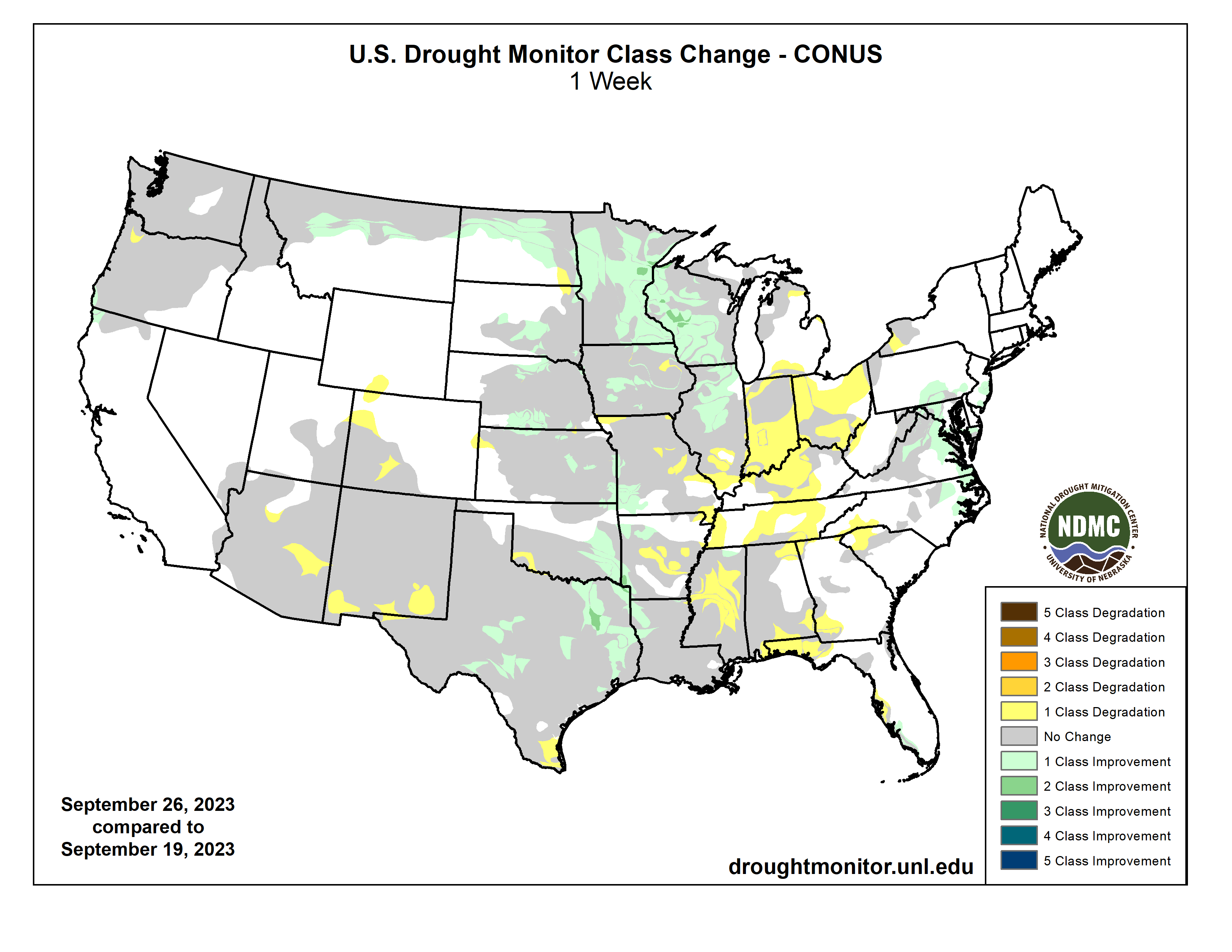
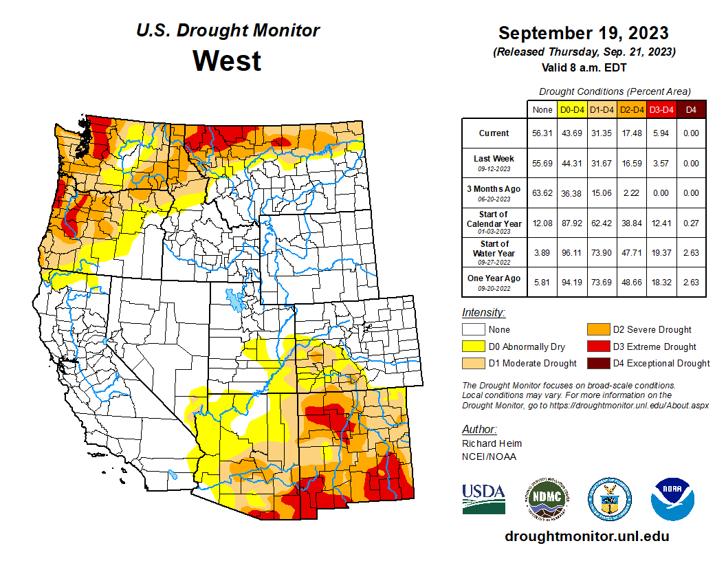
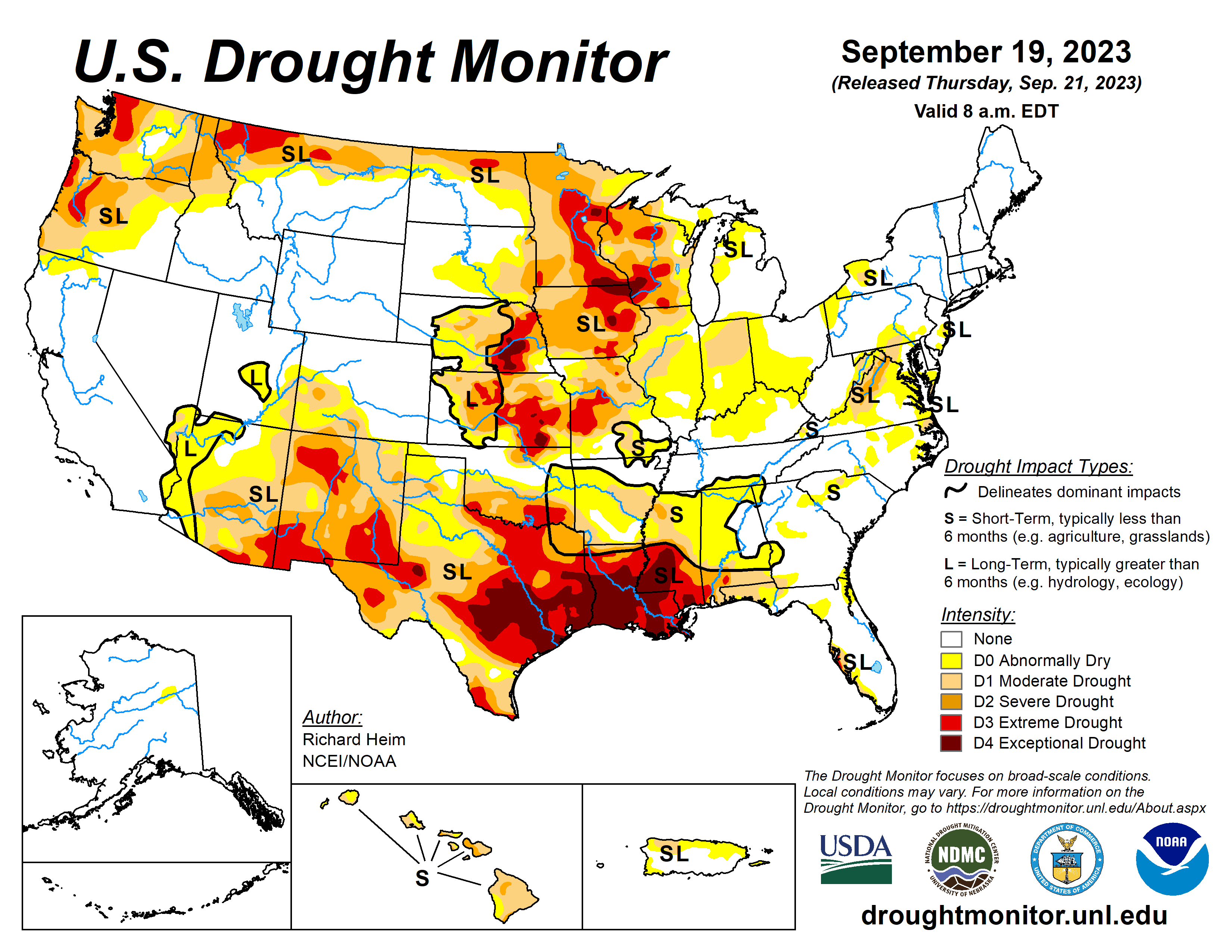
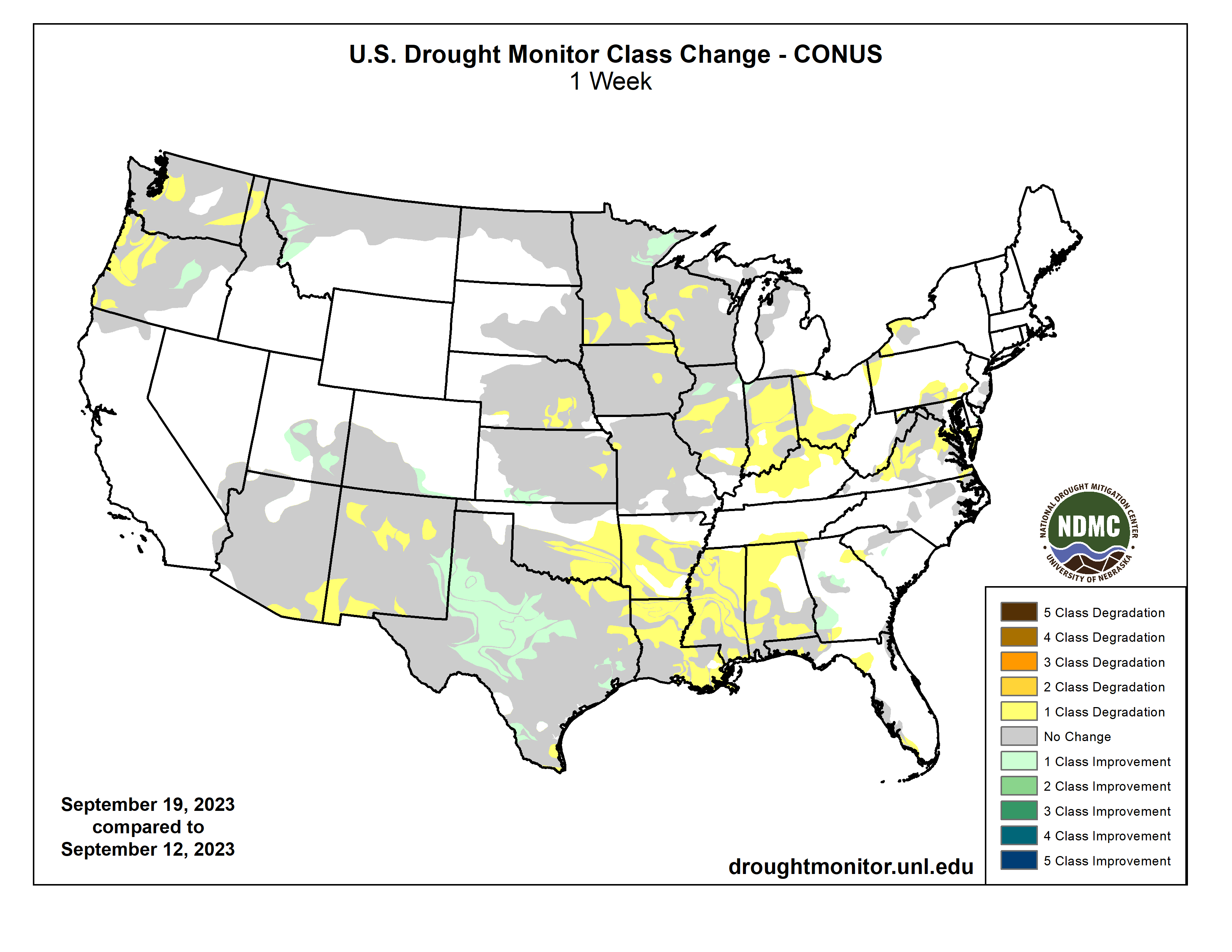
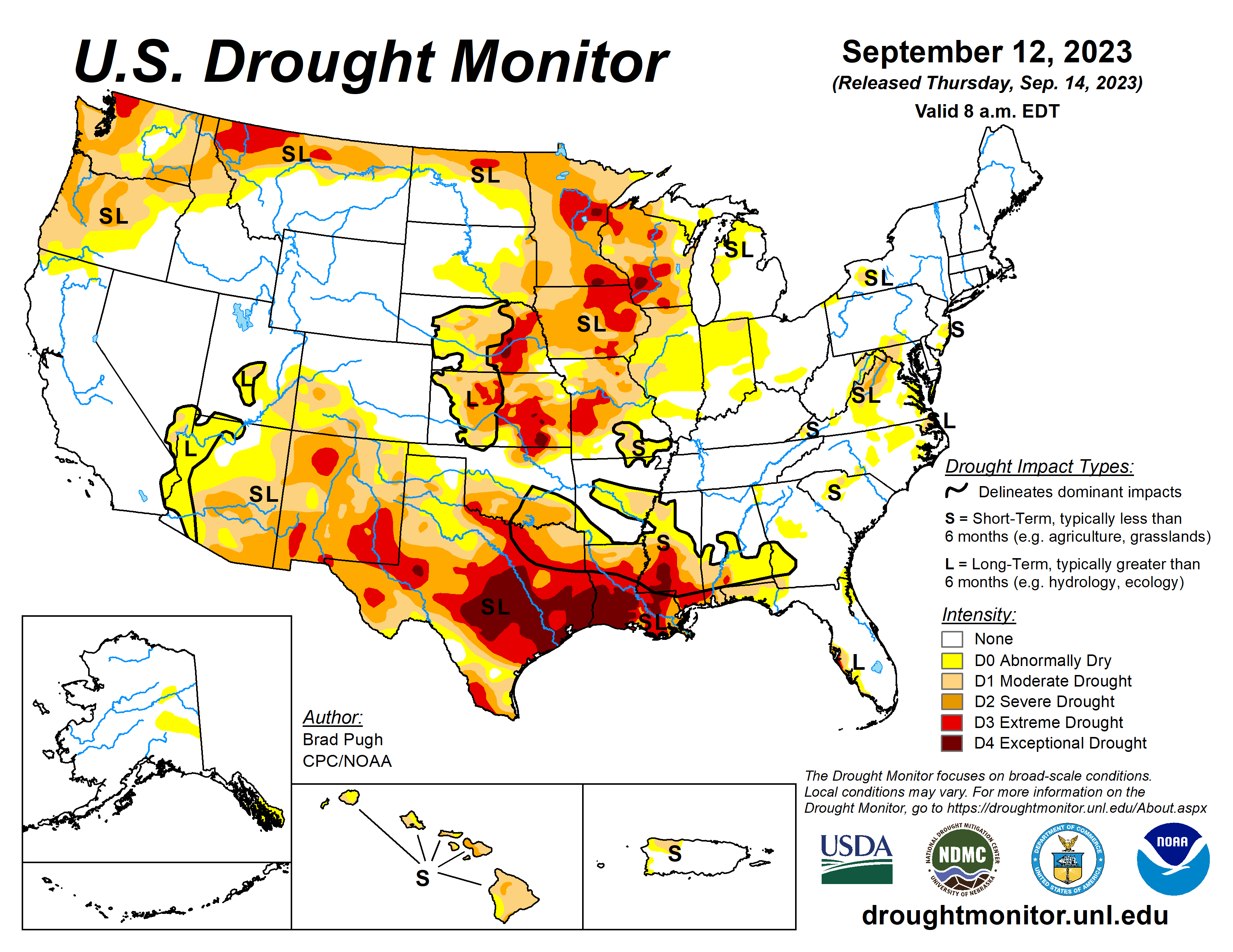
The upper-level circulation over the contiguous U.S. (CONUS) during this U.S. Drought Monitor (USDM) week (September 20-26) consisted of an upper-level ridge of high pressure, that extended from the southern Plains to Hudson Bay, and a low-pressure trough over the eastern Pacific. The trough sent weather systems spinning across the CONUS, with their fronts and surface low pressure systems generating areas of rain across the Pacific Northwest, northern Rockies, and Great Plains to the Mississippi Valley. Meanwhile, Tropical Storm Ophelia moved up the East Coast, spreading rain from North Carolina to southern New England. These areas were wetter than normal for the week. Some of the rain was locally heavy, with over 5 inches reported in places. Much of the rain fell over severely dry areas, which resulted in contraction or reduction in the intensity of drought in parts of the Great Plains, Upper Mississippi Valley, and Mid-Atlantic states. It was drier than normal across the rest of the West, large parts of the central to southern Plains, and most of the country between the Mississippi Valley and Appalachians. The continued dry conditions from the Ohio Valley to central Gulf of Mexico Coast resulted in expansion or intensification of drought and abnormal dryness in these areas. Temperatures averaged warmer than normal beneath the ridge across the Plains, Mississippi Valley, and Great Lakes. The week was cooler than normal in the West and across the East Coast states…
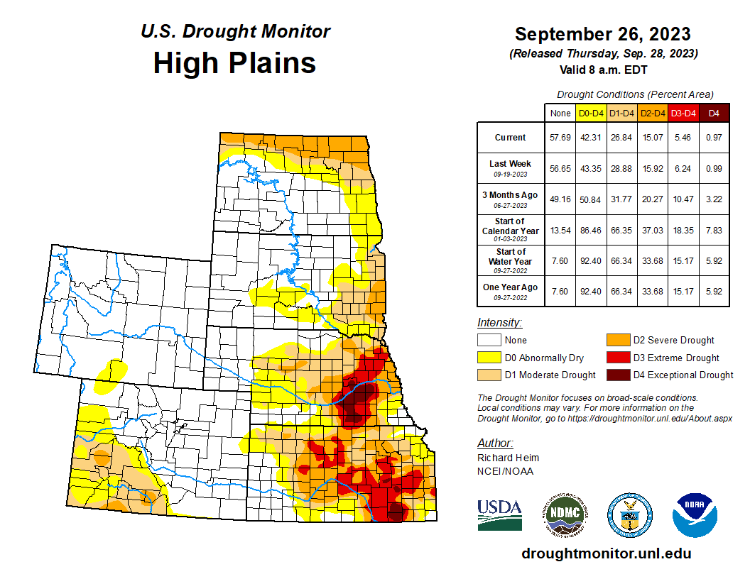
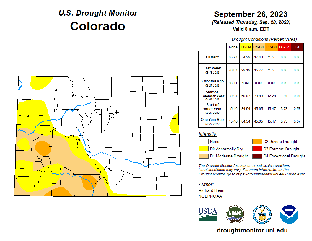
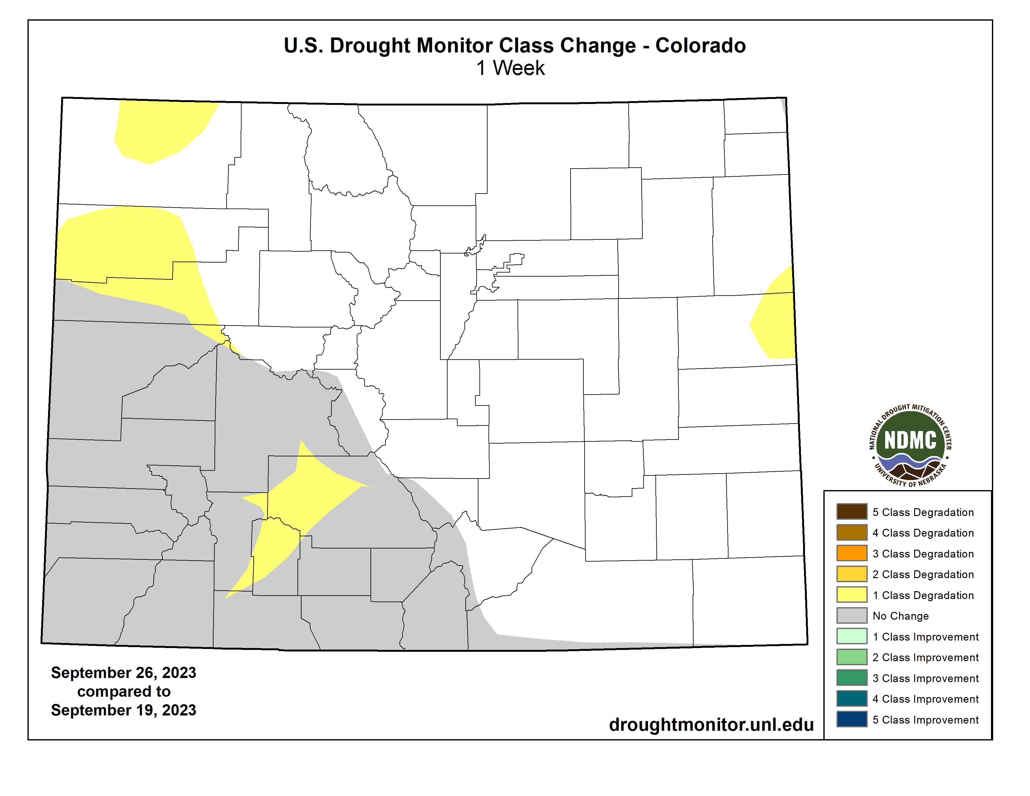
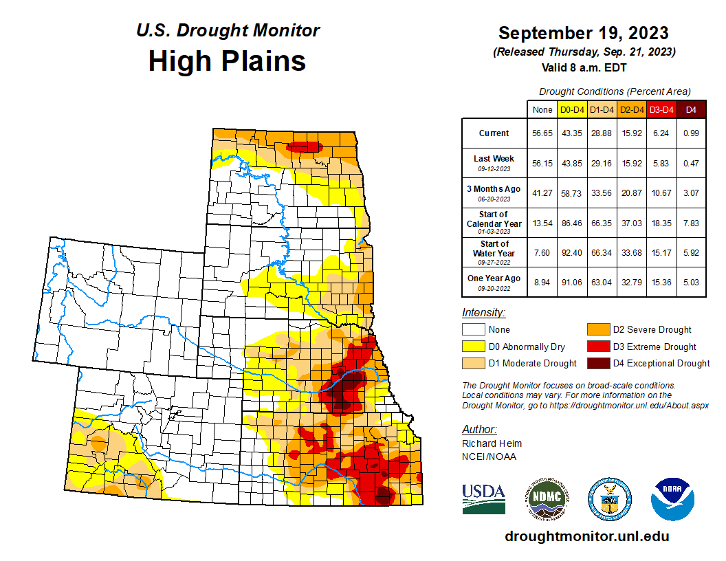
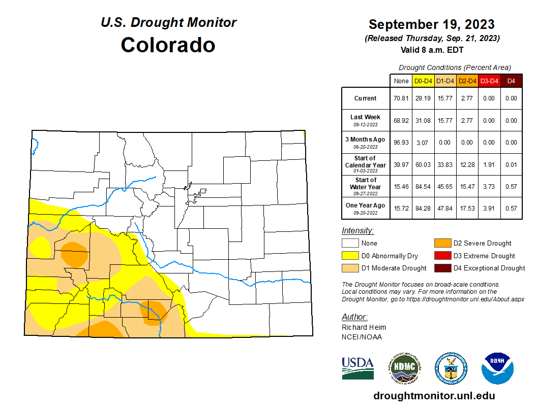
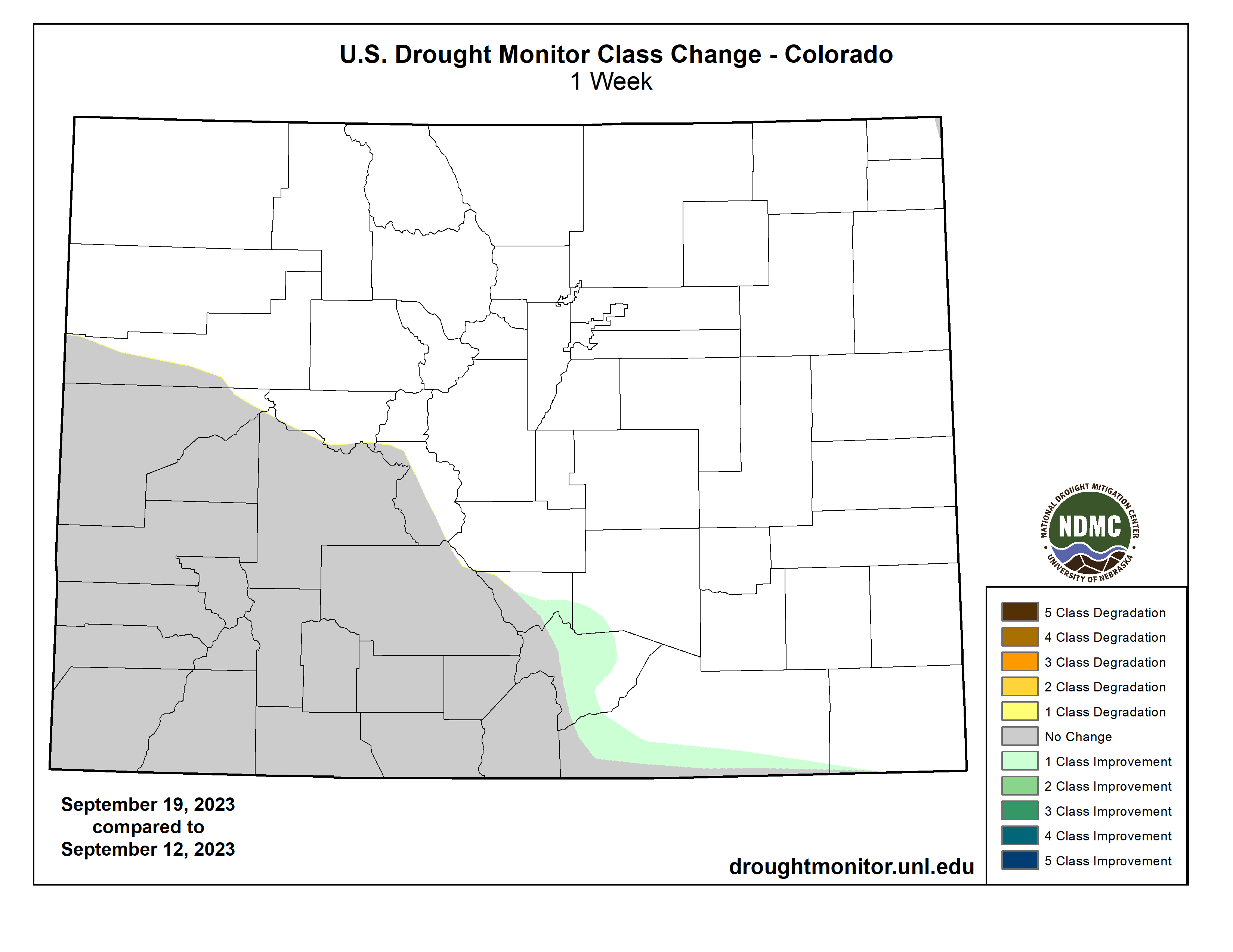
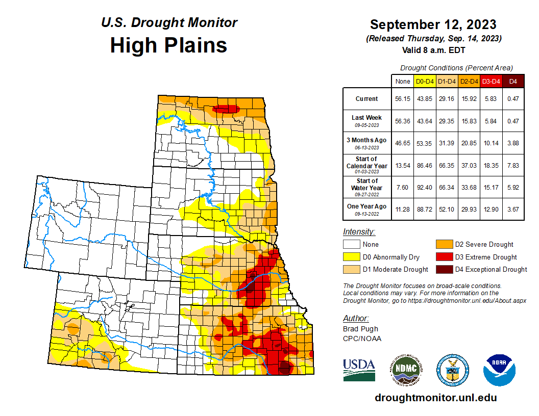
Northern and eastern parts of the High Plains region received half an inch to over 2 inches of rain this week, while Colorado and parts of Wyoming and Kansas received little to no rain. D0-D4 contracted in Nebraska, D0-D3 were reduced in Kansas and North Dakota, and D0-D2 shrank in South Dakota. On the other hand, abnormal dryness returned to Wyoming and abnormal dryness and moderate drought expanded in Colorado. Two-thirds (67%) of the topsoil in Kansas was still short or very short of moisture, according to USDA statistics…
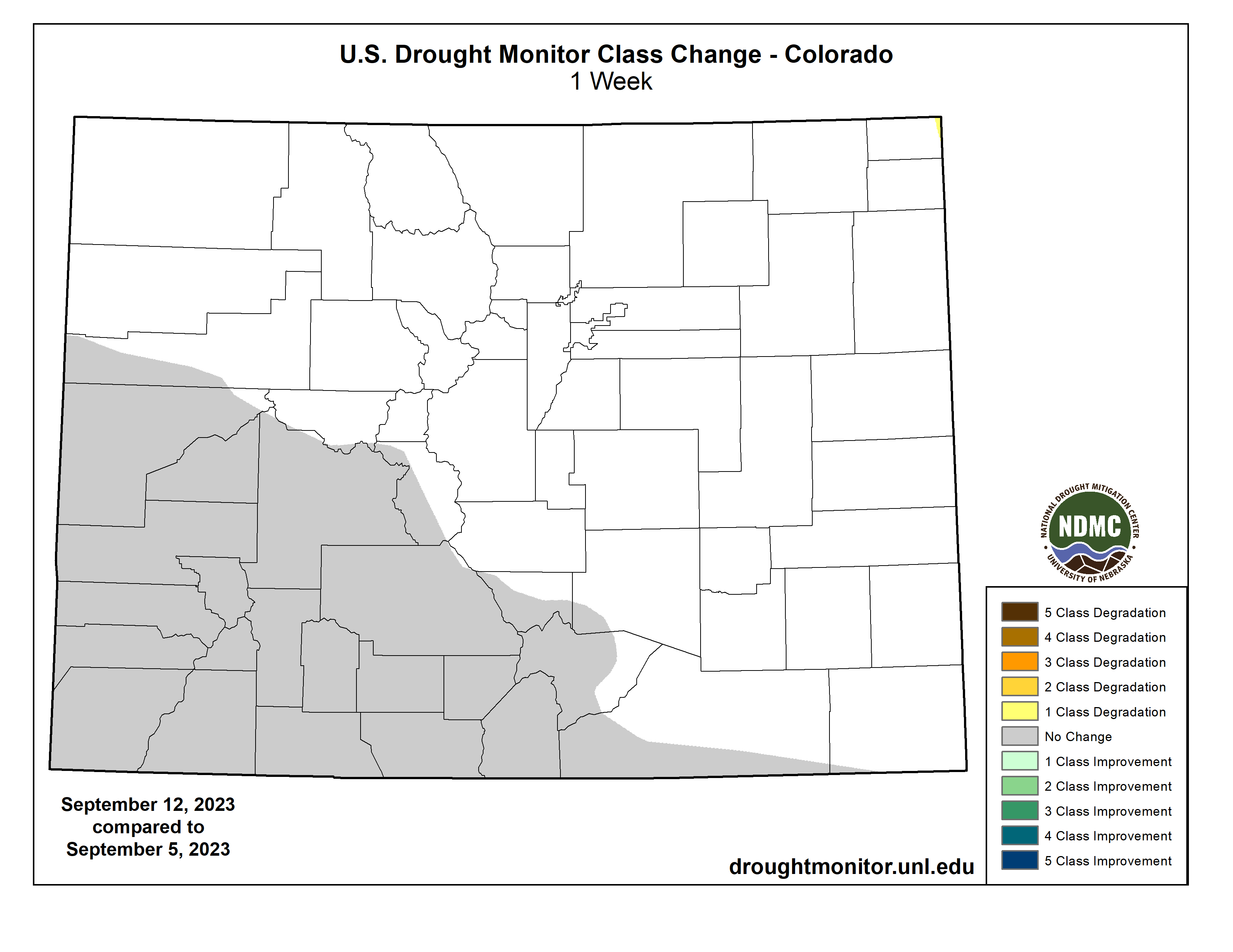
Colorado Drought Monitor one week change map ending September 26, 2023.
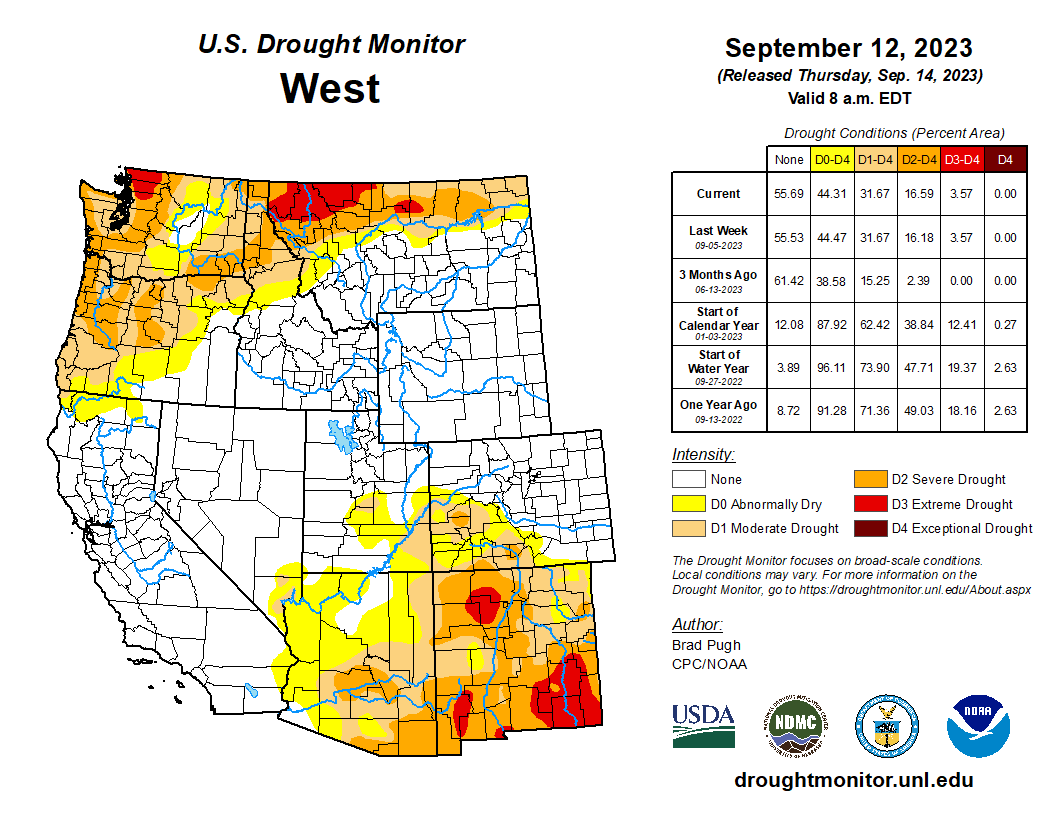
The southerly flow ahead of the eastern Pacific trough created an atmospheric river event that resulted in half an inch to 2 inches of precipitation across coastal areas from northern California to Washington. While the precipitation was helpful, it did not make up for deficits that have built up over the last several months; parts of Washington are still 10 inches or more below normal over the last 6 months. Severe drought was eliminated over southwest coastal Oregon where rainfall totals exceeded 3 inches and the total for the month was above normal. Much of Montana and parts of the northern Rockies received widespread 1 to 3 inches of precipitation; this resulted in contraction of D0-D2 in Montana. The rest of the West region received little to no precipitation. Abnormal dryness and severe drought expanded in Arizona, and extreme to exceptional drought expanded in southern New Mexico. USDA statistics indicated that three-fourths or more of the topsoil moisture was short or very short in Washington (82%), New Mexico (78%), Montana (77%), and Oregon (74%)…
Bands of heavy rain fell across eastern Oklahoma, western Arkansas, and the ArkLaTex, with amounts over 5 inches recorded. Amounts of half an inch to 2 inches extended outward from this central band. But the western half of Texas and Oklahoma, and much of Mississippi and Tennessee received little to no rain. Hydrological impacts were severe in parts of the South region, with Falcon International Reservoir in south Texas near record-low levels, comparable to the levels reached during the droughts of 2002 and 1956 (during the Great Plains 1950s Drought). Temperatures were warmer than normal across most of the region, with anomalies reaching 8 to 12 degrees above normal over Texas. Moderate to exceptional drought expanded in Mississippi, extreme drought expanded in southwest Oklahoma and southern Texas, and abnormal dryness and some moderate drought spread across parts of Tennessee. Abnormal dryness and moderate to exceptional drought were trimmed in parts of Oklahoma, Texas, and Louisiana, with 2-category changes occurring in places. Arkansas had contraction of drought in the west and expansion or intensification in the central to eastern parts. The lack of precipitation and persistently hot temperatures during the last several months in the South have severely dried out soils. According to September 24 U.S. Department of Agriculture (USDA) statistics, 80% of the topsoil moisture in Louisiana was short or very short (dry or very dry). The statistics were 75% for Mississippi, 66% for Texas, 63% for Oklahoma, 62% for Arkansas, and 38% for Tennessee…
Looking Ahead
In the two days since the Tuesday valid time of this USDM, the atmospheric river continued in the Pacific Northwest and rain has fallen across parts of the Midwest, Texas, and Florida. For September 28-October 3, a slow-moving weather system will drop 1 to locally 2 inches of rain across the Ohio Valley and parts of the Upper Mississippi Valley, while a Pacific weather system will move across the northwestern CONUS, spreading 1 to 2 inches of precipitation across the Pacific Northwest and Montana, with heavier amounts (up to 4 inches or more expected) in coastal areas of Washington and Oregon. The Florida peninsula is forecast to get 2 to 4 inches of rain, while the Gulf Coast, Rio Grande Valley, and Mid-Atlantic states can expect an inch or less. The Southwest, New England, Carolina Piedmont, and most of New York and the southern Plains to Iowa are predicted to receive little to no precipitation. Temperatures are progged to be above normal from the Plains to Northeast and near to below normal across the Southeast and West.
For much of the next 2 weeks, the atmospheric circulation will consist of an upper-level trough over the western CONUS and a ridge over the Mississippi Valley. The trough/ridge system will slowly shift east during the period. The Climate Prediction Center’s (CPC) 6-10 Day Outlook (valid October 3-7) and 8-14 Day Outlook (valid October 5-11) favor a fairly stable pattern of warmer-than-normal temperatures from the Plains to East Coast and cooler-than-normal temperatures over the West and over the southeastern half of Alaska. The outlook is for above-normal precipitation over the Plains, Upper Mississippi Valley, northern half of the West, and most of Alaska. Odds favor below-normal precipitation over the Northeast and Appalachian Mountain chain, extending into the Ohio Valley and to the central Gulf Coast, as well as in the Alaska panhandle.
US Drought Monitor one week change map ending September 26, 2023.
Click the link to read the report on the University of Wyoming website (Drew E. Bennett, Max Lewis, Hallie Mahowald, Matt Collins, Travis Brammer, Hilary Byerly Flint, Lucas Thorsness, Weston Eaton, Kristiana Hansen, Mark Burbach, and Elizabeth Koebele). Here’s the executive summary:
The Colorado River Basin is in crisis. There is no longer enough water for all of those who depend on it. The agricultural sector is the largest water user in the Colorado River Basin, meaning that farmers and ranchers are central to both the impacts of and solutions to water shortages. Their involvement will be key to developing effective policy solutions to today’s water crisis.
We surveyed 1,020 agricultural water users throughout six states in the Colorado River Basin to understand their perspectives on the present crisis, their current water conservation practices, and their preferences for strategies to address water shortages going forward. Agricultural water users were primarily concerned about how the current situation could impact water policy, constrain irrigators’ own water use, and constrain other agricultural water users. We also conducted qualitative research to capture preferences for local approaches to managing water and provide additional context on dynamics in the Colorado River Basin, including interviews with 12 agricultural producers and water experts and a focus group with 10 agricultural water users in Colorado.
Perhaps unsurprisingly, we found agricultural water users are already responding to water shortages. Roughly 70% of surveyed agricultural water users have already adopted one or more water conservation practices or adaptation strategies. Importantly, many would consider adopting additional practices. Despite this, few respondents participated in or were aware of formal programs to support water conservation. One exception, however, was the Natural Resources Conservation Service’s Environmental Quality Incentives Program (EQIP). A third of respondents currently or previously participated in EQIP and an additional 37% were aware of the program. Information gathered from interviews and the focus group identified multiple burdens to participation in EQIP and similar programs, and several participants thought the benefits were not worth the effort. These insights suggest an opportunity for revisiting how formal programs meant to incentivize water conservation connect with water users.
Most survey respondents were unlikely to adopt water conservation practices as part of formal demand management or system conservation programs to address water shortages. Only one of eight practices included in the survey – enhancing water delivery systems – had a majority of respondents state that they were likely to adopt the practice. The remaining seven practices had a considerably lower likelihood of adoption. Respondents were also generally opposed to water transfers as a solution to shortages. Opposition was strongest to permanent transfers broadly, as well as to temporary transfers from agricultural to non-agricultural uses. Only temporary transfers from agricultural water users to other agricultural water users had less than 50% opposition. Major barriers to supporting water transfers included concerns about losing water rights, even in temporary transfer arrangements, as well as insufficient financial compensation. Addressing these concerns will be critical to increase participation of agricultural water users in demand management or system conservation. Still, although support for temporary water transfers and demand management practices was low, even equivalently low participation (e.g., 10% to 20%) could help address water shortages as part of a portfolio of strategies for the Colorado River Basin.
We also documented an overwhelming preference for local approaches to managing water shortages and a trust gap with non-local agencies. This was evidenced by respondents’ preference for the local management of formal programs, such as some of the demand management and system conservation programs under consideration, as well as for the administration of funding for water conservation and other programs. Qualitative research participants communicated that strategies to address water shortages must account for the diversity of local contexts across the Colorado River Basin. These strategies could therefore be best implemented at the local level through existing delivery infrastructure and by managers with track records of success. State and federal water managers and agencies involved in program delivery should emphasize building trust with agricultural water users and gaining knowledge about unique features of local contexts. Simply providing additional funding for formal water conservation programs may be inadequate to meet the diversity of challenges across an area of 246,000 square miles. Developing opportunities for dialogue and listening can help foster relationships and improve trust among key stakeholders.
Given the importance of agriculture as the primary water user in the Colorado River Basin, proactively engaging agricultural communities will be critical to successfully managing water shortages. Understanding the perspectives and preferences of agricultural water users, as documented in this report, can help guide the development of solutions that work for producers and other users in the Basin.
Updated Colorado River 4-Panel plot thru Water Year 2022 showing reservoirs, flows, temperatures and precipitation. All trends are in the wrong direction. Since original 2017 plot, conditions have deteriorated significantly. Brad Udall via Twitter: https://twitter.com/bradudall/status/1593316262041436160
Click the link to read the article on the NOAA website:
NOAA’s National Integrated Drought Information System (NIDIS) has announced approximately $2 million in funding for projects to support tribal drought resilience as part of President Biden’s Investing in America agenda. This investment will help tribal nations address current and future drought risk on tribal lands across the Western U.S. while informing decision-making and strengthening tribal drought resilience in a changing climate.
Proposals may request funding of up to $700,000 total to be disseminated in the first year and expended over three years in the form of cooperative agreements. A total of 3–5 projects may be funded depending on the project budget requested.
Applications should be developed by or in full partnership with tribal nations to fund the implementation of activities that address current and future drought risk in the context of a changing climate on tribal lands across the Western U.S.
Competition activities could include but are not limited to conducting drought vulnerability assessments; developing drought plans and communication plans; and identifying primary drought impacts, optimal drought indicators, and/or triggers. Additional activities could include improving drought monitoring; developing drought dashboards with relevant drought data and real-time information; and demonstrating the application of drought data and information to enhance decision-making.
If the primary applicant is not a tribal government, full partnership with a tribal nation can be demonstrated by including at least one full investigator representing a federally recognized tribe on the project, and indicating through the budget and budget justification how funds are being disseminated to the tribal nation.
“NOAA’s Climate Program Office and the National Integrated Drought Information System take the responsibility to engage with tribal partners very seriously, and this funding opportunity is an example of that commitment,” said Wayne Higgins, Ph.D., director of the Climate Program Office. “With climate change impacts further stressing the water supply in the West, it is imperative that we work together to take on the drought challenges in our tribal communities.”
Important Dates:
Letters of Intent (LOI) are due on Thursday, November 2, 2023 by 11:59 p.m. ET.
The deadline for application submission is Thursday, February 15, 2024 by 11:59 p.m. ET.
Letters of Intent or applications received after the above deadlines will not be reviewed or considered.
NIDIS will also be hosting two informational webinars:
The Colorado River is a source of irrigation, hydropower and drinking water for 40 million people in seven Western states. Source: The Water Desk via the Water Education Foundation
Water commissioners from Colorado, Utah, New Mexico, Wyoming are focusing on water demand management in the future of a conservation pilot program. The Upper Colorado River Commission met for a special meeting on Sept. 21 and heard an update regarding the System Conservation Pilot Program (SCPP)…Ultimately, the water commissioners unanimously voted to support narrowing the program in 2024 to focus on water demand management and tools for innovation and local drought resiliency. There was also emphasis during the meeting on improving upon what was learned in 2023…
Collum reviewed three options the commission had on the table for 2024. The first option was to have no program in 2024, but no commissioners spoke in favor of that option. The second option was to maximize water conservation.
Option three, unanimously favored by the commissioners, was presented during the meeting as: “Narrow the 2024 SCPP to explore Demand Management (DM) Studies and Support Innovation & Local Resiliency – implement recommended SCPP improvements AND narrow project criteria towards remaining DM questions and supporting innovation & local resiliency resulting in water conservation.”
[…]
Updated Colorado River 4-Panel plot thru Water Year 2022 showing reservoirs, flows, temperatures and precipitation. All trends are in the wrong direction. Since original 2017 plot, conditions have deteriorated significantly. Brad Udall via Twitter: https://twitter.com/bradudall/status/1593316262041436160
“…I think when we specifically look at the change in hydrology (and) the definite need for the cuts to happen where the cuts are needed in the lower basin,” Mitchell said. “I really want to think about resiliency on the home front and the thing that we do being focused on building security for our own states and our own water users. And so I think when we look at the implementation with the recommended improvements and the narrow project criteria that are focused on supporting innovation and local resiliency that results in water conservation.” — Becky Mitchell
John Echohawk. Photo credit: Allen Best/Big Pivots
Click the link to read the article on the Big Pivots website (Allen Best):
Eulogists gathered at the University of Colorado in Boulder remembered the visions, passions, and well-grounded mentoring by the law professor who knew how to use words and make a difference
Charles Wilkinson arrived in Boulder during 1971 as a young staff attorney for the Native American Rights Fund. In 1975 he left Boulder to teach in Oregon, but then returned for good in 1984 and, according to his eulogists at a memorial on Saturday, created a lasting legacy on the human and physical landscape of the West.
He did so with his words, said Terry Tempest Williams, paraphrasing what she heard Wilkinson tell his own law school students many years ago.
This was on a field trip to Utah’s Canyonlands, such field trips being a crucial part of Wilkinson’s instruction, she explained.
“It felt like family, so much more than a class,” she recalled. “He told his students beneath the stars along the San Juan River, ‘As an attorney, all you have are your words,’ he said. ‘Remember that what you say and how you say it will become truths. Your words may begin as aspirational, but if you back up your word with ground-truthing the beauty and brokenness of the land, the waters and the people you represent, those words will become law, horizon-bidden truths that will come to you from the land itself if you listen and live with an open heart.”
Williams, explained that she had consulted her journal from that trip, which reminded her that his words had felt dangerous She asked for clarification.
“He looked at me. ‘As a writer, you surely know this,’ he said. I didn’t. And then he said, ‘If you say something and know where your words are rooted, and the words will become alive and become true. Aspirational words have the potential to become facts of the future.’ He paused. ‘We just have to make certain the words we choose come from the depth of an ethic of place.’”
The lesson she drew was that there can “be a straight shot from writing to real-world results.” “That,” she added, “changed everything for me as a writer.”
Wilkinson died at the age of 81 in early June, just days before the annual Western water conference sponsored by the academic institution that partly bears his name: the Getches-Wilkinson Law Center for Natural Resources, Energy and the Environment. This year might have been special for him had he lived as there was a lengthy afternoon panel with representatives of many of the tribes in the Colorado River Basin.
John Echohawk and David Getches had founded the Native American Rights Fund in Boulder in 1970. They had some success, but “nobody knew anything about us, and Charles really picked up on that and decided he needed to go into teaching and writing and scholarship,” said Echohawk (seen in the photo above) in his eulogy.
In that, he succeeded. Returning to Boulder, Wilkinson became affiliated with the law school in 1987. In time, Wilkinson and Getches put the University of Colorado Law School on the map as “basically the greatest law school in the West when it comes to federal Indian law. That is the reputation of this law school,” said Echohawk during the sunshine-swathed memorial held outside the architecturally-commanding four-story CU Law School building.
“Our friendship spanned 50 years,” said Echohawk. When I would think about trying to draw tribal leaders together to develop consensus about building a political agenda for Indian country or planning education or institutes focusing on specific topic areas important to tribes, I would call Charles to see his advice. When we talked, he would listen for a while and suggest what we had to do. He was always spot on. He was always supportive and somehow made time to be an essential part of the many meetings we held across Indian country and Washington D.C.”
Wilkinson, said Echohawk, “always knew how to laugh and joke and appreciate life.”
All 11 of the speakers told stories or shared observations about Wilkinson’s boundless enthusiasms, including the outdoors. He taught Echohawk how to flyfish. His enthusiasm could be traced to a love for Samuel Taylor Coleridge’s “Rime of the Ancient Mariner.”
“You have to pay attention to nature, every piece,” he had instructed.
This enthusiasm extended to his family. One of his sons told about Wilkinson’s efforts to get another son into an elite summer camp designed for high school basketball stars. Wilkinson succeeded and then traveled to New York so he could watch the proceedings courtside. That was not something parents normally did. He did that with most everything.
“My dad was very good at being a dad,” said his son Seth. “He was emphatically present with us.”
Those enthusiasms continued into his more advanced years. Sarah Krakoff, a professor at the CU Law School and former director of the law school’s American Indian Law Clinic, told of meeting him as he walked up the law school steps a decade ago. She asked him how he was doing.
“Life just keeps getting better and better,” he replied. “But only up to a point.”
Colorado Attorney General Phil Wieser, a former l dean of the law school, reported that as a law professor he only once got a 6.0, the highest course evaluation possible, from his students. It was for a course he co-taught with Wilkinson.
“All the students knew that he cared deeply about them,” Weiser explained.” He respected them. He empowered them. And that’s something I will carry with me.”
It was not, he went on to say, just in the classroom. “Charles made everyone feel important. Charles cared about everyone and people loved working with Charles, and that is something else that will stay with me. His presence and his ability to be present were truly exceptional. “
And Wilkinson could be determined. Weiser said he was there as Wilkinson lobbied Mike Conners, then an undersecretary in the Interior Department, for designation of the Bears Ears National Monument in Utah. “He was persistent, and he was going to win.” He also credited Wilkinson with leading the fundraising effort for the law school building, a very challenging task. Students — not just law students — voted to raise their own fees to pay for the building built to the highest green-building standards of the time.
Wilkinson’s optimism was a theme noted by many speakers. “Charles Wilkinson was an unwavering optimist,” declared Lolita Buckner Inniss, the current dean of the University of Colorado Law School. “ He never tempered his enthusiasm in any way.”
Several identified a link to the late writer Wallace Stegner who taught at Stanford University when Wilkinson graduated from law school there in 1966.
“One cannot be pessimistic about the West. This is the native home of hope,” wrote Stegner in one of his most celebrated essays. “ When it fully learns that cooperation, not rugged individualism, is the quality that most characterizes and preserves it, then it will have achieved itself and outlived its origins. Then it has a chance to create a society to match its scenery.”
Said Weiser, “Light in time of darkness is precious. It always matters. Charles, through his optimisms, through his humbleness, through his romantic spirit and aspirational spirit for a better West, for a better humanity, made us better.”
Updated Colorado River 4-Panel plot thru Water Year 2022 showing reservoirs, flows, temperatures and precipitation. All trends are in the wrong direction. Since original 2017 plot, conditions have deteriorated significantly. Brad Udall via Twitter: https://twitter.com/bradudall/status/1593316262041436160
Click the link to read the article on The Denver Post website (Elise Schmelzer). Here’s an excerpt:
Federal land managers have proposed blocking future oil and gas development on more than a million acres of Colorado’s Western Slope as they reshape how they handle energy development in the face of a drying and warming West. The Bureau of Land Management’s draft management plan for a swath of land between the Utah border and Eagle would close 1.6 million acres to potential oil and gas leasing. If approved, the plan would forestall the drilling of hundreds of future wells.
“What we’re seeing here is a draft management plan that is really reflecting the changing economy of the region, which is becoming less dependent on oil and gas extraction,” said Erin Riccio, advocacy director for the Carbondale-based Wilderness Workshop…
The management plan would drastically reduce the percentage of land available for leasing — from 85% of the area to 20%. It would block roughly 599 new oil and gas wells over the next 20 years, according to the BLM. Currently, 125,400 acres in the area already are closed to oil and gas leasing. If the BLM enacts its proposed plan — called “Alternative E” based on its review of multiple possibilities — an additional 1.4 million acres would be closed…
There was another option considered by the BLM, labeled Alternative F, that would close even more land to oil and gas leasing. That plan would block about 95% of the Western Slope area at issue to leasing, leaving only 104,100 acres open to development. Alternative F would add protections for habitats of endangered species such as the humpback chub, a river fish, as well as for recreation areas, the Dolores River corridor, watersheds for municipal water supplies and habitats for trout, birds and bighorns. The plan would block the creation of about 779 wells, the BLM estimated.
Wyoming angler Jeff Streeter’s shadow casts over the shallow flow of the Encampment River, a tributary to the North Platte River, July 21, 2021. (Dustin Bleizeffer/WyoFile)
Click the link to read the article on the WyoFile website (Anne MacKinnon):
Climate change poses challenges for Wyoming water law, seen these days on the Grand Encampment River southwest of Saratoga.
The Encampment River valley is like many small, irrigated valleys in Wyoming. It was once the home of a few pioneer ranches that built a network of ditches, but the ranches have been divided up, the river has moved over time, and people have kept irrigating using the old ditches, sometimes with a little jerry-rigging. The Encampment valley is also narrow, with usually more than enough water, so state water officials haven’t had to “regulate” to keep water use in line with water rights.
Enter the Sinclair Refinery near Rawlins, Carbon County’s biggest employer. Its workforce includes people from the Encampment valley, located some 40 miles away. In just the last year and a half, the oil company that took over the refinery bought a ranch on the Grand Encampment River.
The attraction: the old water rights on the ranch. The goal: to bolster the refinery’s water supply in the face of climate change.
Two years out of the last six, the Upper North Platte Basin has seen climate change in low snowpack. It has meant that in spring, the refinery couldn’t legally use its own 100-year-old water rights. Refinery managers had to arrange for temporary use of older water rights from elsewhere. Buying the Encampment ranch offers the new refinery’s owners, called HF Sinclair, a more permanent solution for those low snow-pack years.
That has some neighbors worried. Now, how water works in the Encampment valley — which lands are irrigated or not, when and through what ditch — must be examined.
It might seem neighboring irrigators wouldn’t care if a ranch won’t use its water rights in some years. But in a classic Wyoming spot like the Encampment valley, where the water rights and ditches and the irrigation practices and the water table and the water runoff from irrigation are interwoven, the refinery’s water use could disrupt the current pattern.
The HollyFrontier Sinclair refinery in Sinclair, Wyoming as seen in July 2011. (James St. John/FlickrCC)
HF Sinclair’s plan will test the capacity of Wyoming water law to serve both the refinery and the Encampment irrigation community in the era of climate change. Will water officials’ decisions start to unravel the fabric of the community, as some fear, or will it leave that fabric substantially intact?
Map of the North Platte River drainage basin, a tributary of the Platte River, in the central US. Made using USGS National Map and NASA SRTM data. By Shannon1 – Own work, CC BY-SA 4.0, https://commons.wikimedia.org/w/index.php?curid=79266632
Most climate change headlines in Wyoming have focused on the Colorado River Basin, but the Upper North Platte River Basin — embracing both the Sinclair refinery on the North Platte and the Encampment River, a North Platte tributary upstream — has also gotten steadily hotter in the last 20 years.
HF Sinclair’s proposal to move water rights from one location to another — in response to the impending climate crisis — is a prospect that has long alarmed Wyoming irrigators. The fear is that “drying up” a ranch can damage local economies. Such moves were once mostly illegal in Wyoming, and many irrigators believe they still are. But 50 years ago in another national crisis — rising energy prices, creating demand for power plants in Wyoming — the state changed its law to allow such moves if they meet strict standards. There must, for instance, be proof of how much water was consumed at the original spot — no more can be consumed at the new spot, and the amount of water that used to return to the stream from the original irrigation must be left in the stream at that point.
Notably, HF Sinclair is not proposing to dry up its ranch with any such permanent move of water rights. Only in low snowpack years would the refinery activate a new arrangement — a proposed “exchange.” The plan is that in those years the refinery would legally get to use its rights on the North Platte despite low flows, while it would not irrigate its Encampment ranch at all in spring or summer. That would allow Encampment water unused at the ranch to flow down the North Platte to Pathfinder Reservoir as “makeup” water, as required by the Wyoming water exchange law.
HF Sinclair also says it will invest in the interconnected headgate and ditch system on the Encampment to make sure that when the ranch does not tap the Encampment River at all for a year, neighbors still get water for their rights.
There is heavy pressure for an uncomplicated review of HF Sinclair’s plan. The company does not hesitate to underline the implications for sustaining local jobs. To get approval, the company has hired a phalanx of high-powered law and technical people, including a former Wyoming State Engineer.
But leading irrigators on the Encampment have asked state officials for a thorough review — they don’t, however, want the cost and trouble of hiring lawyers and engineers to fall on them. The Wyoming Stock Growers, meanwhile, this summer called for public meetings on water changes as a review of Sinclair’s plans got underway.
Neighbors don’t have grounds to complain if a ranch just decides not to irrigate in a few years. But because HF Sinclair is proposing a legal change, the ranch neighbors have brought concerns to the state water officials who must decide whether to approve the exchange.
To get that approval, HF Sinclair must take two steps: first clean up the water rights on the ranch, and then get the exchange petition granted.
Cleanups are standard in places like the Encampment River, since actual use of old water rights in Wyoming often changes over decades, as streams move a little and ditches fall into disuse. Often old water rights must be identified and nailed down to the current use, at the expense of the right-holder. Sometimes, cleanups get complicated. The strict standards of Wyoming’s water-moves law can apply, if change over time includes water moving some distance.
HF Sinclair is asking for a simple cleanup, which could avoid that scrutiny. The company has filed documents to show that only relatively insignificant changes in irrigation have taken place in over a century of ranch operations — nothing that should invoke the scrutiny required for serious movements of water rights.
There are, of course, all kinds of questions that could arise in HF Sinclair’s cleanup: How much of the ranch’s Encampment River rights have actually been used, where and from what headgates? Does the groundwater level in low-lying lands mean that water consumption there can’t really be stopped, and maybe fields there haven’t required much irrigation water? Has enough irrigation water been used on other ranch fields to provide the proposed “makeup” water for the exchange?
How intensely to review HF Sinclair’s cleanup is a decision for the state Board of Control (the State Engineer and the superintendents of Wyoming’s four geographical water divisions). Then HG Sinclair’s separate request for an exchange – a transaction expressly encouraged by state law – goes to the State Engineer alone to decide.
It will take months or years to see how Wyoming’s water rights review process plays out in this case. And the practical impact may finally depend on how many low snowpack years the future holds for the North Platte Basin. But ultimately, what happens on the Encampment will say a lot about how the state’s water law system will handle the pressures on water that are brought by climate change.
Yampa River Basin via Wikimedia.
Relatively smooth approval of an exchange on the Encampment could encourage towns and industries in Wyoming’s Green and Little Snake River basins to seek their own exchanges. For them, exchanges could be a solution to water supply shutdowns threatened by climate change on the Colorado River. In recent years the State Engineer’s Office has suggested that exchanges could be useful for that purpose, using reservoirs as makeup water.
On the Encampment, HF Sinclair’s experts include former State Engineer Pat Tyrrell, former Division I Water Superintendent Brian Pugsley, and veteran water lawyer Dave Palmerlee.
The facts on the ground may well be such that the refinery’s proposal would easily survive any tough scrutiny. But the way the consultants have couched the requests makes it appear they’re betting they won’t trigger that kind of review, so they get approval — and relatively quickly.
The Encampment community’s fear of local damage has brought an audience to the normally unnoticed Board of Control meetings, however.
Nearby ranchers would like to see Sinclair offer a signed contract for the investment in headgates and ditches to secure access to all neighbors’ water rights. They don’t want to contend with Sinclair’s experts in formal hearings or appeals. But they do want a very careful state review.
If we needed any more motivation to help save our ailing rivers, it should have come with the findings of a recent study, which revealed that “Nowhere is the biodiversity crisis more acute than in freshwater ecosystems.”
Rivers, lakes and inland wetlands cover 1% of the Earth but provide homes for 10% of all its species, including one-third of all vertebrates. And many of those species are imperiled — some 27% of the nearly 30,000 freshwater species so far assessed by the IUCN Red List. This includes nearly one-third of all freshwater fish.
How did things get so bad? For some species it’s a single action — like building a dam. But for most, it’s a confluence of factors — an accumulation of harm — that builds for years or decades.
A high desert thunderstorm lights up the sky behind Glen Canyon Dam — Photo USBR
1. Dam Obstructions
One of the single largest threats to river biodiversity comes from dams, which provide humans with electricity, water reserves and other benefits but come with ecological costs. The loss of free-flowing rivers divides watersheds into unconnected fragments and changes water flow, quality and temperature. It also blocks the transport of sediment, and can obstruct the movement of animals, including migratory fish — and the species like freshwater mussels — which depend on those fish.
In the United States, dam-building has imperiled Atlantic salmon on the East Coast as well as many runs of the West Coast’s five salmon species. But the ripple effects can extend to aquatic insects, birds and riparian plants.
If we needed any more motivation to help save our ailing rivers, it should have come with the findings of a recent study, which revealed that “Nowhere is the biodiversity crisis more acute than in freshwater ecosystems.”
Rivers, lakes and inland wetlands cover 1% of the Earth but provide homes for 10% of all its species, including one-third of all vertebrates. And many of those species are imperiled — some 27% of the nearly 30,000 freshwater species so far assessed by the IUCN Red List. This includes nearly one-third of all freshwater fish.
How did things get so bad? For some species it’s a single action — like building a dam. But for most, it’s a confluence of factors — an accumulation of harm — that builds for years or decades.
The Cuyahoga River on fire in 1952. The river caught fire at least 13 times and helped spur an avalanche of water pollution control activities such as the Clean Water Act. Photo via the Environmental Protection Agency
2. Pollution
What happens on land doesn’t stay on land.
The Clean Water Act, passed 50 years ago, has done a lot to improve the water quality of rivers in the United States, as have similar regulations around the world. But we still have a long way to go.
Some waterways remain a dumping ground for toxic chemicals, even decades after those threats were identified. Others face new threats from pharmaceuticals that pass through water treatment facilities (after passing through our bladders) and accumulate in the bodies of aquatic animals. Fish full of antidepressants is no joking matter. Neither are PFAS, so-called “forever chemicals,” that end up in rivers — and aquatic animals — after leaching from industrial sites, military bases or incinerators.
The nutrients we use on farms and livestock operations also wash into rivers and streams. That runoff, full of nitrogen and phosphorus, fuels an overgrowth of algae which deprive the waters of oxygen, driving away or killing marine life in so-called “dead zones.” The situation is likely to get worse as climate change fuels stronger storms and warmer waters.
Beef cattle on a feedlot in the Texas Panhandle. Photo credit: Wikimedia
3. Grazing
Waste from animal feedlots pollutes rivers, but cattle that graze on millions of acres of public and private lands across the American West — and in many other nations — are a threat, too.
The livestock can overgraze and trample riparian areas, leading to the loss of plants, an increase in erosion and reduced stability of streambanks. A loss of vegetation along banks increases water temperature — a detriment to cold-water fish. And the sediment — and sometimes waste-fill runoff — threatens water quality and fish, including native trout.
Updated Colorado River 4-Panel plot thru Water Year 2022 showing reservoirs, flows, temperatures and precipitation. All trends are in the wrong direction. Since original 2017 plot, conditions have deteriorated significantly. Brad Udall via Twitter: https://twitter.com/bradudall/status/1593316262041436160
4. Climate Change
The effects of climate warming are already being felt around the world, with rivers drying up in the United States, China, Germany, France and many other nations over the past few months.
That’s only going to get worse: In the United States, where projections show western mountains will experience a significant loss of snowpack in the next 35 to 60 years. Less snow and an earlier snowmelt will alter river flows and groundwater, which will affect numerous plants and animals across the region.
Some of those same species are already suffering from other harms from human development. Salmon, for example, that have been cut off from cold-water upstream habitat by dams are now further imperiled as low water flows heat up the rivers to temperatures that endangered the fish.
A view of Foothills Mobile Home Park, which suffered a total loss during the September 2013 flood in Lyons. (Courtesy of town of Lyons)
Heavy rainstorms supercharged by climate change can also cause flooding that sweeps sediment, chemicals and other harmful runoff into rivers and creeks. These storms can cause municipal sewage systems to be overwhelmed and discharge untreated water into rivers.
Warming temperatures can also exacerbate droughts, limiting water for drinking, irrigation and maintaining healthy flows in rivers and streams to support wildlife.
Magpie river. Credit Boreal-River via The Conservation Alliance
5. Not Enough Protections
We may love our rivers, but we simply don’t afford them enough protection. Laws and regulations offer piecemeal measures, and funding for river-conservation programs remains elusive. Efforts to establish legal “personhood” for rivers haven’t gained much traction and some of our existing tools haven’t been utilized effectively.
In the United States, far less than one-half of 1% of the country’s river miles have been protected under the Wild and Scenic Rivers Act, established in 1968. The law can help protect rivers and their banks from new dams and mining claims, and often from logging and roadbuildling. New legislative efforts in Congress to expand the program, including the River Democracy Act, have yet to move forward. Other nations have proposed their own new laws, but whether they’ll pass — or do enough — remains to be seen.
Of course, the risks to waterways are as varied as the ecosystems themselves. To find out more about threats to our rivers — and ways to protect and restore them — check out this selection of stories from our archives:
Mrs. Gulch’s Maximilian sunflowers September 24, 2023. Helianthus maximiliani is a North American species of sunflower known by the common name Maximilian sunflower. Helianthus maximiliani is native to the Great Plains in central North America, and naturalized in the eastern and western parts of the continent. It is now found from British Columbia to Maine, south to the Carolinas, Chihuahua, and California. The plant thrives in a number of ecosystems, particularly across the plains in central Canada and the United States. It is also cultivated as an ornamental
A burnt sign on Larimer County Road 103 near Chambers Lake. The fire started in the area near Cameron Peak, which it is named after. The fire burned over 200,000 acres during its three-month run. Photo courtesy of Kate Stahla via the University of Northern Colorado
Click the link to read the article on the Fort Collins Coloradoan (Mile Blumhardt). Here’s an excerpt:
Recent flights over Colorado’s historic Cameron Peak and East Troublesome fire burn scars revealed a troubling observation: Three years after the state’s largest wildfires scorched nearly 400,000 acres, nearly half of those acres are still so severely burned that little to no regrowth has taken place. That has caused concern among a cadre of local researchers from federal and state governmental agencies, Colorado State University, conservation groups and private industry studying the vast scar from 2020.
Sarah Beck, Arapaho and Roosevelt National Forests fire recovery coordinator, said more precise aerial mapping of the scar will be forthcoming, but for now, large areas of the burn scar are not seeing expected revegetation recovery.
“These patches of high burn severity are so large there is a real possibility of recovery taking 50 years or longer,” she said. “It’s really concerning. I don’t think we have seen this in North America. I think this is a new condition in complexity.”
[…]
With the enormity and complexity of post-fire impacts still looming three years later to human safety, critical water supplies, recreational facilities and fish and wildlife, the U.S. Forest Service has begun a new approach. In August, it announced a partnership with the nonprofit conservation organization American Forests to develop a longer-term reforestation strategy for the burn scars. The planning will continue to be developed collaboratively with input from community-connected partners, research institutions and local and state agencies.
“The problem is really big, and it is not something we have the capacity to tackle alone,” Beck said.
A burnt sign on Larimer County Road 103 near Chambers Lake. The fire started in the area near Cameron Peak, which it is named after. The fire burned over 200,000 acres during its three-month run. Photo courtesy of Kate Stahla via the University of Northern Colorado
Smoke billows from the Cameron Peak Fire. Photo by Karina PuikkonenBeaver wetland in the Cameron Peak Fire perimeter. Photo: Evan Barrientos/Audubon RockiesThe Cameron Peak fire soon after it started on Aug. 13, 2020. By Sept. 11, the fire had grown to more than 102,000 acres (now >200,000 acres) and was not expected to be considered out until Oct. 31. Photo credit: InciWeb via The Colorado SunEvacuees leave Granby as the East Troublesome Fire burns in the distance, Oct. 22, 2020. (Chase Woodruff/Colorado Newsline)The East Troublesome Fire burns north of Granby on Oct. 22, 2020. (Chase Woodruff/Colorado Newsline)Lands in Northern Water’s collection system scarred by East Troublesome Fire. October 2020. Credit: Northern WaterEast Troublesome Fire. Photo credit: Northern WaterSmoke from the East Troublesome fire looms over Granby Reservoir. Photo credit: Evan Wise via Water for ColoradoBent lodgepole pine in some areas revealed intensity of the wind. Photo/National Park Service via Big PivotsLand scarred in Rocky Mountain National Park from the East Troublesome Fire, October 2020. Credit: Northern Water via Water Education ColoradoLittle that was live remained standing in this area along Colorado Highway 25, north of Windy Gap Reservoir, after the East Troublesome Fire. Agricultural and municipal water users will see broad, lingering effects of the fire. Photo credit: Aspen JournalismThis house north of Windy Gap Reservoir was among the 589 private structures burned in the East Troublesome Creek Fire. Water managers worry soil damage by the fire will cause sediment to clog irrigation ditches and municipal water infrastructure alike. Photo credit: Aspen JournalismStark scenes like this were abundant for those who traveled through the East Troublesome burn area on Christmas Day. Photo/Allen BestThe East Troublesome Fire burns near the Farr Pump Plant on Lake Granby October 2020. Credit: Northern WaterThe East Troublesome Fire burns in Grand County in October 2020. Credit: Northern WaterThe East Troublesome Fire in Grand County burned down to the shore of Willow Creek Reservoir, one of the lakes in Northern Water’s collection system in Grand County. Dec. 13, 2020. Credit: Jerd SmithA view from the highway of the massive East Troublesome wildfire smoke cloud near Rocky Mountain National Park in Colorado on October 16, 2020. Photo credit: InciwebMany homes along Highway 34 and west of Granby Reservoir were spared, perhaps the result of the luck of winds. Photo/Allen BestEast Troublesome Fire. Photo credit: Brad White via The Mountain Town NewsThe East Troublesome fire as it tore through the Trail Creek Estates subdivision on Oct. 21, 2020. (Brian White, Grand Fire Protection District)East Troublesome Fire October 21, 2020 via Wildfire Today.The East Troublesome fire as seen from Cottonwood Pass looking north on the evening of Wednesday, Oct 21, 2020. (Andrew Lussie via InciWeb via The Colorado Sun)
These sprinkler guns irrigate fields outside of Carbondale. The Upper Colorado River Commission voted on Thursday to continue a federally funded program in 2024 that pays water users to cut back. CREDIT: HEATHER SACKETT/ASPEN JOURNALISM
Colorado River managers on Thursday [September 21, 2023] decided to continue a water conservation program designed to protect critical elevations in the nation’s two largest reservoirs.
The Upper Colorado River Commission decided unanimously to continue the federally funded System Conservation Program in 2024 — but with a narrower scope that explores demand management concepts and supports innovation and local drought resiliency on a longer-term basis. This was the third of three options that commissioners had regarding SCP and whether they would continue it next year. The other options, which commissioners rejected, were to not do a program in 2024 or to maximize the program, with a focus on increasing the amount of water conserved.
Becky Mitchell, Colorado’s commissioner to the UCRC, said she could support doing system conservation again since it will now be focused on water security and innovative conservation for upper basin water users.
“We have an opportunity to do better this time around and learn from last year’s experience and do it in a way that’s responsive to the input that we heard across the upper basin,” Mitchell said. “Option 3 has modified the program in a way that with that prioritization of projects that support innovation of water conservation and development of drought-resiliency tools, it’s something that I can support.”
The System Conservation Program is paying water users in the four upper basin states — Colorado, New Mexico, Wyoming and Utah — to voluntarily cut back with $125 million from the Inflation Reduction Act. According to UCRC officials, nearly $16.1 million was spent on system conservation in 2023. Nearly $1 million of that went to 22 project participants in Colorado, resulting in a water savings of about 2,517 acre-feet. (An acre-foot is the amount of water needed to cover an acre of land to a depth of 1 foot and can supply one or two families a year).
Project participants in Colorado are being paid an average of about $394 for every acre-foot of water they conserve in 2023. Officials say the average price per acre-foot across the upper basin is $422. Although water users from all sectors can participate, all of the projects in Colorado this year involved agricultural water users on the Western Slope.
System conservation was first tried in the upper basin from 2015 to 2018 and saved an estimated 47,000 acre-feet, at a cost of about $8.6 million. Last year, the UCRC announced it would restart a system conservation program as part of its 5-Point Plan, aimed at protecting critical elevations in Lake Powell and Lake Mead, which have fallen to record-low levels in recent years because of overuse, drought and climate change.
Updated Colorado River 4-Panel plot thru Water Year 2022 showing reservoirs, flows, temperatures and precipitation. All trends are in the wrong direction. Since original 2017 plot, conditions have deteriorated significantly. Brad Udall via Twitter: https://twitter.com/bradudall/status/1593316262041436160
The program for 2024 is being rolled out sooner than the one for 2023 was, giving irrigators more time to plan for next season, which could lead to more interest and enrollment. UCRC Executive Director Chuck Cullom gave commissioners a timeline proposal: an announcement of the 2024 program Oct. 2; request for proposals issued Oct. 10; project applications due Dec. 11, followed by a nearly two-month review period of applications by the U.S. Bureau of Reclamation, the upper basin states and UCRC’s consultant. Contracts are slated to be executed by March 15.
“We believe that this draft timeline would significantly address the shortcomings that we had identified in the lessons learned report and provide the improvements in the application and review process for a more successful program in 2024,” Cullom said.
The 2024 program’s focus on studying demand management addresses an often-heard criticism of SCP: Any water conserved in a system conservation program is not guaranteed to make it to Lake Powell and could just be picked up by the next downstream user. Conceptually, system conservation and demand management are the same: paying irrigators on a temporary and voluntary basis to conserve water.
But there’s an important legal difference. If water conservation is done under the umbrella of an official demand management program, that water can be “shepherded” to a special 500,000-acre-foot pool in Lake Powell.
The 2019 Drought Contingency Plan created the possibility of this demand management pool for the upper basin states to protect against a compact call. Although Colorado studied the issue extensively from 2019 to 2021, including with nine workgroups, the upper basin states have so far not implemented a demand management program to take advantage of this pool in Lake Powell.
Cullom said the third option will also implement recommendations for improvements that came from interviews with program participants, nongovernmental organizations, tribes and water managers across the upper basin. These include a more transparent and upfront pricing process; more education and outreach to water users; and more information about project applications in Colorado and opportunity to provide comment.
Missouri Heights resident Cassie Cerise pets her dog Dinah on her ranch outside of Carbondale. Cerise enrolled the field behind her in the Upper Colorado River Commission’s System Conservation Program in 2023, getting paid to not irrigate it.
CREDIT: HEATHER SACKETT/ASPEN JOURNALISM
Local concerns
During the 2023 project approval process, the Glenwood Springs-based Colorado River Water Conservation District — whose mission is to lead in the protection, conservation, use and development of water on the Western Slope — and the Durango-based Southwestern Water Conservation District voiced concerns about a lack of transparency.
Mitchell had also promised the districts that they could participate in the review and approval process for applications, thereby securing a measure of local control. But she later walked back that commitment, saying the UCRC had sole authority in the approval process.
Information about project specifics is still scant, with much of the information about the exact location of projects, how much participants are being paid, names of participating ditches, and information about water rights such as priority dates and decreed amounts of water in the contracts blacked out.
Mitchell has publicly stated that this second round of the SCP reboot would be more transparent, at least in Colorado, but has not said exactly how.
Paying water users to irrigate less continues to be controversial on the Western Slope, with fears that these temporary and voluntary programs could lead to a permanent “buy and dry” situation that would negatively impact rural farming and ranching communities. Water managers have repeatedly said that large amounts of water cannot be saved through system conservation in the upper basin and that cuts are needed from the lower basin — California, Nevada and Arizona — to bring the Colorado River system back into balance.
At an August meeting of the Water Resources and Agriculture Review Committee of the Colorado legislature, Sen. Dylan Roberts, a Democrat whose District 8 spans several Western Slope counties, including Routt, Garfield, Eagle and Summit, asked Mitchell and Cullom if Colorado would engage in system conservation prior to the lower basin implementing substantial and permanent reductions in water use.
Mitchell replied that system conservation is done with the goal of learning what lessons can be gleaned about Colorado’s water resilience and to offer flexible tools for irrigators, not to enable continued overuse in the lower basin.
“We need to ask ourselves: Is it good for Colorado?” she said. “We realized that there was only so much we could do. People wanted to do something, but they wanted it for Colorado.”
Raymond Langstaff irrigates his fields outside of Rifle in May 2022. A water conservation program that pays irrigators to use less water from the Colorado River (SCPP) will be offered by the upper basin states starting in October 2023. CREDIT: HEATHER SACKETT/ASPEN JOURNALISM
From email from the Colorado Water Conservation Board (Katie Weeman):
September 21, 2023 (Denver, CO) – the Upper Colorado River Commissioners voted to implement the System Conservation Pilot Program (SCPP) for the 2024 Water Year. SCPP provides Upper Basin water users with the opportunity to participate in temporary, voluntary, and compensated water conservation. SCPP simultaneously allows the Upper Colorado River Commission (UCRC) and Upper Division States to learn from the piloted conservation efforts, expanding knowledge on aspects like monitoring, measurement, and local benefits or impacts. For water users, it provides opportunities to develop tools to build resilience and adapt to long-term drought.
The revamped SCPP integrates input from Upper Basin water users. Changes include:
An earlier application window, beginning in October 2023, to provide operational certainty for applicants.
A transparent pricing mechanism to provide clarity to applicants.
Increased education and outreach to ensure water users are fully informed.
Expanded information about project applications in Colorado with the opportunity to provide comment.
Prioritization of projects that support innovative water conservation and development of drought resiliency tools.
“We learned a lot about SCPP last year, so this year’s revamp integrates a lot of input from Colorado water users,” said Becky Mitchell, Colorado River Commissioner for the State of Colorado. “SCPP should—and can—work in a way that makes sense for Colorado. The pilot program can provide flexibility for Coloradans who want or need to explore innovative conservation projects. As we continue to learn together and do what we can to be part of the solution, I continue to push for reductions where it matters most: in the Lower Division States.”
“There is no silver bullet for drought resiliency in Colorado,” said Lauren Ris, Director of the Colorado Water Conservation Board. “SCPP is one tool in the State’s toolkit that we can all learn from. It can fund innovation, letting water users try something new, because they have that financial certainty. And, because it’s totally voluntary, temporary, and compensated, SCPP lets Coloradans choose for themselves.”
At the September 21 UCRC meeting, Commissioner Mitchell strongly advocated for SCPP reforms that would be responsive to Colorado water users’ input. More information on the revamped SCPP process will be available in the coming weeks. The Congressional reauthorization for SCPP expires in Fall 2024.
Browns Canyon National Monument protects a stunning section of Colorado’s upper Arkansas River Valley. The area is a beacon to white water rafters and anglers looking to test their skills at catching brown and rainbow trout. Photo by Bob Wick / @BLMNational
The San Juan River, below Navajo Reservoir. Photo: Brent Gardner-Smith/Aspen Journalism
From email from Reclamation (Susan Novak Behery):
September 21, 2023
Due to forecast sufficient flows in the critical habitat reach of the San Juan River, the Bureau of Reclamation has scheduled a decrease in the release from Navajo Dam from 850 cubic feet per second (cfs) to 800 cfs for Friday September 22nd, at 4:00 AM.
Reclamation continues to release project water to fulfill a project water release request by the Jicarilla Apache Nation’s subcontractors, The Nature Conservancy and the New Mexico Interstate Stream Commission, in addition to the normally scheduled release required to maintain the minimum downstream target baseflow.
Releases are made for the authorized purposes of the Navajo Unit, and to attempt to maintain a target base flow through the endangered fish critical habitat reach of the San Juan River (Farmington to Lake Powell). The San Juan River Basin Recovery Implementation Program recommends a target base flow of between 500 cfs and 1,000 cfs through the critical habitat area. The target base flow is calculated as the weekly average of gaged flows throughout the critical habitat area from Farmington to Lake Powell.
Click the link to read the article on the Denver Water website (Jay Adams):
What a difference a year makes for the front of Arapahoe County’s Administration Building in Littleton.
Since the 1970s, the west side of the building had been covered by a 3-acre field of unused, water-intensive Kentucky bluegrass.
Recognizing the need to set a positive example regarding water conservation for the long term, in August 2022 the Arapahoe County Commissioners launched a plan to seed the field with a mix of prairie grasses in an effort to transform the bland expanse of bluegrass into a more natural ColoradoScape that will use less water.
The project is part of Arapahoe County’s broader sustainability initiative that includes reducing water consumption indoors and outdoors.
One year later, all the planning has paid off and the grasses are flourishing.
Arapahoe County’s Administration Building in Littleton has a new ColoradoScape with its prairie grass field on the west side of the building. The transformation is a part of the county’s sustainability efforts to reduce water consumption. Photo credit: Denver Water.
“We’re very pleased with how the grasses have come in and are thriving,” said Lisa VanderHeyden, senior project manager of facilities and fleet at Arapahoe County. “We were lucky and got a nice boost from Mother Nature with all the rain in May and June, which really helped the grasses grow in their first season.”
The old field was chosen for landscape transformation because it was considered to have “nonfunctional grass,” which is grass that requires frequent watering from an irrigation system but is not used for activities or events.
The old Kentucky bluegrass field as seen before the transformation in 2022. The field required extensive watering to stay green and was considered nonfunctional grass because it was not used for activities or events. Photo credit: Arapahoe County.
The new field contains a mix of grasses with varying heights and textures. It resembles what the field looked like before people settled the area and started irrigating the land.
It typically takes about three years to fully establish a native grass area, in which the grasses fill in and squeeze out the weeds. Once established, the grass should be able to survive solely on the moisture provided by Mother Nature.
This is how Arapahoe County’s ColoradoScape is going. See how it started.
Arapahoe County’s staff will actively manage the field and the county anticipates saving approximately 1.5 million gallons of water per season due to the switch from the bluegrass.
“The field will have a very natural look and, like other prairie grass fields in the area, the colors will change depending on the amount of precipitation throughout the year,” VanderHeyden said.
The field, seen here in August 2023 after it was mowed for the first time. The field, which will be mowed once a year, has a mix of native prairie grass seeds including blue grama, buffalo grass, sideoats grama, western wheatgrass, green needlegrass and sand dropseed. Photo credit: Denver Water.
Changing landscapes across the Southwest
The building is in Denver Water’s service area and is a great example of a greater push across the Southwest to reduce the amount of nonfunctional grass and help boost the struggling Colorado River, where Denver Water gets half of its water supply.
“We’ve been really impressed with Arapahoe County’s efforts to examine their nonfunctional grass areas and make water-saving changes,” said Austin Krcmarik, water efficiency planner at Denver Water.
The landscape transformation in front of Arapahoe County’s Administration Building includes a garden that features low-water-use plants designed to do well in Colorado’s semi-arid climate. Photo credit: Denver Water.
“For decades, Kentucky bluegrass has been the default landscaping option for many government buildings and now we’re seeing a shift to more natural looking, water-saving ColoradoScapes.”
So, how do you start a new prairie grass field? Hear Arapahoe County officials discuss the project:
Creating a long-term plan
Krcmarik and Arapahoe County agree that there are a number of steps to take when doing large landscape transformation projects:
Consult with the growing number of landscape experts who support water-saving transformations.
Work with landscapers who are willing to research what will work best and commit to support the transformation beyond the initial implementation.
Get the full support of management.
Think the project through, from start to finish and consider long-term maintenance.
Mature trees remain in front of the building. Arapahoe County has experimented with different types of irrigation techniques to ensure they stay healthy as irrigation to the field is reduced. Photo credit: Denver Water.
Inform the public about the reasons behind the landscape change.
Develop a plan for how to prepare the site for new seeds and plants.
Upgrade and/or modify irrigation systems to protect mature trees if the new landscape will use less water.
Develop a plan to manage weeds during the early years.
Choose plants that can survive without irrigation after establishment.
Denver Water and Arapahoe County are part of the Colorado Native Grass Working Group, which includes dozens of other cities, landscape and water professionals to put together a guide on best practices for installing low-water grass landscapes. You can check out their resources and sign up for their email list at coloradonativegrass.org.
Signs point out the challenges weeds present during landscape transformation. Grasses typically take around three years to become fully established and squeeze out the weeds. Photo credit: Denver Water.
State support
The turf replacement project was awarded a grant from the Colorado Water Conservation Board for supporting the Colorado Water Plan’s goal of encouraging municipalities to reduce water use through landscape change.
“It’s been great working with Denver Water, and we appreciate their support and also the grant from the CWCB,” said Anders Nelson, Arapahoe County public information officer.
“While this is a relatively small field, we hope to learn from our work, share and improve the processes and continue to look for other opportunities to reduce our water consumption here in Arapahoe County.”
Mrs. Gulch’s landscape September 14, 2023. Note the freshly mowed Blue gramma area at center left.
Potential Water Delivery Routes. Since this water will be exported from the San Luis Valley, the water will be fully reusable. In addition to being a renewable water supply, this is an important component of the RWR water supply and delivery plan. Reuse allows first-use water to be used to extinction, which means that this water, after first use, can be reused multiple times. Graphic credit: Renewable Water Resources
Click the link to read the article on the Colorado Politics website (Marianne Goodland). Here’s an excerpt:
A Douglas County commissioner recommended individuals who contributed to his campaign to sit on a new water commission that would be tasked with ensuring sufficient future water supply for the county. The individuals included two principals of a water development firm that has been trying to get buy-in for a proposal to pipe water from the San Luis Valley into Douglas County, a move that has been met with stiff opposition from governments in the valley.
Douglas County commissioners, from left: George Teal, Lora Thomas and Abe Laydon. Courtesy Douglas County
Douglas County’s commissioners met earlier this week to begin deciding who they would put on the new 11-member water commission, which will include three representatives of each district and two at-large members. The nominees were among those who submitted applications for the water commission, a list that has been kept confidential.
During Monday’s discussion, Commissioner George Teal announced his eight picks for members: Three for his district, three for another district, plus two at-large members. Five of his picks have made substantial contributions to his political campaigns, including two principals from Renewable Water Resources, the firm that pitched moving water from San Luis Valley’s groundwater to Douglas County…On Aug. 13, 2021, Renewable Water Resources principals, their spouses and friends contributed to pay down Teal’s 2020 campaign debt. The contributions totaled $16,000. Among the funders were Tonner and John Kim, both RWR principals, and Craig Broughton, an associate of Tonner’s. All three are on Teal’s list for the water commission. He also named Castle Pines City Councilman Roger Hudson, who is deputy chief of staff for the House Minority caucus at the state Capitol and who also made several contributions to Teal’s campaign for the 2020 election. Teal also recommended Harold Smethills, who doesn’t live in Douglas County but owns property in Sterling Ranch. Smethills has also contributed to Teal’s campaign. In a previous discussion, Teal had proposed allowing people who don’t live in the county but own property there to apply for the water commission.
Several Pacific weather systems moved through the jet-stream flow during this U.S. Drought Monitor (USDM) week (September 13-19). The upper-level circulation still consisted of an upper-level ridge over the western contiguous U.S. (CONUS), but it was weakened by the traversing Pacific weather systems. The ridge kept most of the western U.S. dry with warmer-than-normal temperatures from northern California to Montana. Cold fronts and surface low-pressure systems, that accompanied the weather systems, brought rain to the Southwest, southern Plains, Southeast, and Northeast. Heavy rain fell across western to central Texas, improving drought conditions. The rain in the East fell mostly on non-drought areas. The fronts kept temperatures cooler than normal from the Southwest to most of the southern Plains and across much of the country from the Mississippi River to East Coast – only the Gulf of Mexico coast and New England had a warmer-than-normal week. In addition to getting rain from frontal systems, parts of New England were soaked by the remnants of Hurricane Lee over the weekend. The northern Plains and parts of the central Plains, the Great Lakes, and the Mississippi and Ohio Valleys had a drier-than-normal week. The dryness this week was a continuation of dry conditions that have lasted for several months – in some cases for years – across parts of the country and that have dried out soils across more than half of the CONUS. According to U.S. Department of Agriculture statistics, 58% of the nation’s topsoil moisture and 59% of the subsoil moisture was dry or very dry. For topsoil moisture, based on data going back to 2015, this amount is second only to the drought of 2022, which peaked at 68%. The continued dry conditions resulted in expansion or intensification of drought and abnormal dryness across parts of the Mississippi and Ohio Valleys, Mid-Atlantic states, and Pacific Northwest…
Half an inch to locally 2 inches of rain fell over western and southern parts of the High Plains region, mostly in Colorado, southern Kansas, and parts of Nebraska. But most of Wyoming, the Dakotas, Nebraska, and Kansas were dry this week. The rain trimmed D0 in southern Colorado and contracted D0-D1 in southwestern Kansas. D0 and D3 expanded in eastern Kansas. D0 expanded in parts of southwest Nebraska, but the compounded effects of excessive summer heat and overall dryness over the last 1 to 2 years resulted in expansion of D3 and D4 in parts of southeast Nebraska. Sporadic summer showers have not had much of an impact on the multi-year drought, with low soil moisture continuing and stressed vegetation as seen on satellite-based indicators. A farmer/rancher in Nuckolls County, Nebraska reported stock ponds had never gone dry in his 65 years living in the county until this summer and his crops were all burned up. Reports like this are typical across the region. According to USDA statistics, 50% or more of the topsoil moisture was short or very short in Kansas (68%), Nebraska (60%), North Dakota (51%), and South Dakota (50%), and 50% or more of the subsoil moisture was dry or very dry in Kansas (75%), Nebraska (65%), and North and South Dakota (52% each). Half (50%) of the pasture and rangeland in Kansas was in poor to very poor condition…
Colorado Drought Monitor one week change map ending September 19, 2023.
Half an inch to locally 2+ inches of rain fell over parts of Arizona, New Mexico, and Utah, but most of the West received no rain this week. High evapotranspiration due to persistently hot temperatures, low streamflow and soil moisture, and lack of precipitation over 1-month to 12-month time scales resulted in the expansion of D2 and D3 in northwest Washington, expansion of D2 in eastern Washington and the Idaho panhandle, and expansion of D1 and D2 and the introduction of D3 in western Oregon. Rain from weather systems in past weeks, especially the remnants of Hurricane Hilary, resulted in contraction of D1 in central Oregon, D0 and D1 in Utah, and D0 to D3 in western Montana. While parts of New Mexico received rain this week, other parts were dry. The weather system that dumped rain on Texas also soaked east-central New Mexico, so drought contracted there. But prolonged dryness resulted in expansion of D1 and D2 in central to northeast New Mexico and D3 in northwest and southern parts of the state, as well as D3 expansion in adjacent southeast Arizona. According to USDA reports, more than two-thirds of the topsoil was short or very short of moisture in New Mexico (87%), Washington (83%), Montana (82%), and Oregon (74%), and more than two-thirds of the subsoil moisture was short or very short in New Mexico (87%), Montana (79%), Washington (78%), and Oregon (75%). Half or more of the pasture and rangeland was in poor or very poor condition in Washington (65%) and Arizona (57%)…
A large part of Texas received over 2 inches of rain this week. These areas included western to central Texas and parts of the Southeast and Far South. Over 5 inches of rain was reported at stations near Lubbock, Austin, Houston, and Galveston Bay, with the CoCoRaHS station at Nassau Bay 0.9ENE reporting 9.57 inches. The rain resulted in the contraction of D1-D4 in western to central Texas and in the southeast and far south sections of the state. Areas of half an inch to 2 inches of rain occurred over parts of western and southern Oklahoma. But most of Arkansas and Mississippi, parts of Louisiana and eastern Oklahoma, and much of the Rio Grande Valley were dry this week. The compound effects of the excessive heat and dryness of the summer and early fall prompted expansion of abnormal dryness and moderate to exceptional drought in Mississippi, Louisiana, northeastern Texas, and southeast Oklahoma, with abnormal dryness and moderate drought expanding in Arkansas and eastern Oklahoma. The high evapotranspiration and lack of rain has dried out soils and resulted in impacts that include low or dry streams and cattle ponds, desiccated pasture and cropland, and stressed vegetation dropping leaves. Reports include: hay and grasses are short and insufficient for cattle; soils are so dry that the ground is as hard as concrete. Reports like this are typical across the region. According to USDA reports, topsoil moisture is short or very short across 80% of Louisiana, 74% of Mississippi, 72% of Oklahoma, 69% of Arkansas, and 59% of Texas. The subsoil moisture statistics are: 87% Louisiana, 73% Oklahoma and Texas, 67% Mississippi, and 55% Arkansas. Over 60% of the pasture and rangeland is in poor to very poor condition in Texas (71%) and Louisiana (68%), and over 40% in Oklahoma (49%) and Mississippi (41%)…
Looking Ahead
In the two days since the valid time of this USDM, rain has fallen across parts of the West, parts of the Plains to Mississippi Valley, and parts of Florida. For September 21-26, a strong weather system will slowly move out of the Rockies into the Plains and spread heavy rain across much of the Plains to Mississippi Valley, while a low-pressure system moves along the East Coast, spreading heavy rain to coastal areas, and a third Pacific weather system brings rain to coastal areas from northern California to Washington. Weekly precipitation totals could range from 1 to locally 5 inches or more in these regions. Other parts of the Far West, the Four Corners states, much of the Southeast, and the Appalachians to eastern Great Lakes are expected to receive little to no precipitation. Temperatures are expected to be warmer than normal across parts of the Plains to the Mississippi River Valley and Great Lakes.
The Climate Prediction Center’s (CPC) 6-10 Day Outlook (valid September 26-30) favors above-normal precipitation from northern California to North Dakota and across much of the Southeast, with below-normal precipitation centered over Colorado and extending from Missouri to the Great Lakes and New England. Odds favor near normal precipitation for Alaska. The outlook is for below-normal temperatures over southwest Alaska and the Far West in the CONUS, and above-normal temperatures from the Rockies to Appalachians and over northeast Alaska.
The temperature pattern favored in CPC’s 8-14 Day Outlook (valid September 28-October 4) is a continuation of that in the 6-10 Day Outlook, with cooler-than-normal temperatures extending to the Rocky Mountains and the warmer-than-normal area extending to the East Coast. The area favored for above-normal precipitation extends across the Great Plains, while the below-normal area extends to the Lower Mississippi Valley. Odds favor above-normal precipitation for most of Alaska.
US Drought Monitor one week change map ending September 19, 2023.
The San Juan River near Navajo Dam, New Mexico, Aug. 23, 2015. Photo credit: Phil Slattery Wikimedia Commons
From email from Reclamation (Susan Novak Behery):
September 19, 2023
Due to the forecast for the coming week indicating sufficient flows in the critical habitat reach of the San Juan River, the Bureau of Reclamation has scheduled a decrease in the release from Navajo Dam from 900 cubic feet per second (cfs) to 850 cfs for Wednesday September 20th, at 4:00 AM.
Reclamation continues to release project water to fulfill a project water release request by the Jicarilla Apache Nation’s subcontractors, The Nature Conservancy and the New Mexico Interstate Stream Commission, in addition to the normally scheduled release required to maintain the minimum downstream target baseflow.
Releases are made for the authorized purposes of the Navajo Unit, and to attempt to maintain a target base flow through the endangered fish critical habitat reach of the San Juan River (Farmington to Lake Powell). The San Juan River Basin Recovery Implementation Program recommends a target base flow of between 500 cfs and 1,000 cfs through the critical habitat area. The target base flow is calculated as the weekly average of gaged flows throughout the critical habitat area from Farmington to Lake Powell.
In May of 2009, three concurrent venues each showed different artwork, photo essays and educational material about ditches.
Exhibits and featured events at the Boulder Public Library drew crowds of curious Coloradans, while visitors to the Dairy Center for the Arts enjoyed eclectic displays inspired by local water scenes. Various bits of sculpture lined Boulder Creek near the headgates of the Boulder and Left Hand Ditch.
Special programs included tours, storytelling, films, and a symposium of expert speakers. Here, you can revisit parts of the Ditch Project with our comprehensive archive of images, podcasts, and movie clips.
New content will be added here sporadically. Check back here for more updates.
The Forest Service is awarding more than $1 billion nationwide in grants to plant trees in cities, tackle climate change and make green spaces more accessible to less wealthy neighborhoods. Nearly $70 million will go to more than 30 projects in the Mountain West, which include expanding urban orchards in Nevada, improving tree canopies in Colorado and adding education programs in New Mexico. The goal is to help communities that do not have easy access to parks and forests, and are more vulnerable to the urban heat island effect. These areas have historically been overlooked when it comes to adding green spaces, and as a result, residents face increased energy bills, bad air quality and a greater risk of sickness and death…
“You’re focusing on places and welcoming people who might not have felt at home in the fancy neighborhoods with the big trees and making sure that people know that they deserve that, too,” [Xochitl] Torres Small said when announcing the funding. “That there is an opportunity for a cooler place for their kids to enjoy in a park nearby shaded by the trees.”
It’s all part of the agency’s Urban and Community Forestry Program. It received more than 800 applications requesting more than $6 billion in funding – showcasing the desire to grow more trees in urban areas. The grants are funded by the federal Inflation Reduction Act. Colorado and New Mexico received the most grant money in our region – more than $20 million each to fund green spaces projects. Nevada was not far behind with nearly $16 million, whileIdaho, Utah and Wyoming received less than $6 million each.
Torres Small said representatives are already knocking on people’s doors to ask if they want to plant a tree.
Denver skyline, view is west from City Park. Photo credit The City of Denver.
Arkansas Valley Conduit map via the Southeastern Colorado Water Conservancy District (Chris Woodka) June 2021.
Click the link to read the article on the Reclamation website (Anna Perea and Darryl Asher):
President Biden’s Bipartisan Infrastructure Law supporting major water infrastructure project to provide clean, reliable drinking water to 39 communities in southeastern Colorado
Sep 15, 2023
LOVELAND, Colo. – The Bureau of Reclamation has awarded a contract for the second segment of trunkline of the Arkansas Valley Conduit to Pate Construction Co., Inc. for $27,216,950.00. This contract, partially funded by President Biden’s Bipartisan Infrastructure Law, funds construction of Boone Reach 2, which includes a 5.4 mile stretch of water pipeline and 7.4 miles of fiber conduit. Construction will follow Colorado State Highway 96 from North Avondale to Boone, Colorado.
President Biden’s Investing in America agenda represents the largest investment in climate resilience in the nation’s history and is providing much-needed resources to enhance Western communities’ resilience to drought and climate change. Through the Bipartisan Infrastructure Law, Reclamation is investing a total of $8.3 billion over five years for water infrastructure projects, including water purification and reuse, water storage and conveyance, desalination and dam safety. An overall $160 million has been allocated so far from the Law to complete the Arkansas Valley Conduit project.
This is a major infrastructure project that, upon completion, will provide reliable municipal and industrial water to 39 communities in southeastern Colorado. The pipeline will bring water from Pueblo Reservoir to Bent, Crowley, Kiowa, Otero, Prowers, and Pueblo counties. It is projected to serve up to 50,000 people in the future; equivalent to 7,500 acre-feet of water per year.
“We’re looking forward to this next project milestone,” said Jeff Rieker, Eastern Colorado area manager. “Today’s contract award allows the project to maintain the momentum we’ve built over the past year and helps us achieve the ultimate goal of bringing clean and reliable water supplies to the people of southeastern Colorado.”
“The Arkansas Valley Conduit is vitally important to the people of the Lower Arkansas Valley, so it is very rewarding to see the Bureau of Reclamation moving ahead,” said Bill Long, president of the Southeastern Colorado Water Conservancy District, local sponsors of the Arkansas Valley Conduit. “The Southeastern District also is working to complete this project as quickly as possible to provide a better quality of water for the people of the valley.”
Work on the first segment of trunk line began in spring of 2023 with completion anticipated in 2024. Reclamation expects work on the second segment, Boone Reach 2, to begin in late 2023 with completion slated for late summer 2025.
As the Arkansas Valley Conduit project moves forward, under existing agreements, Reclamation plans to construct the trunkline, water tanks, and related components, while the Southeastern Colorado Water Conservancy District coordinates with communities to fund and build the project’s water delivery pipelines. Eventually, the Arkansas Valley Conduit will connect 39 water systems along the 103-mile route to Lamar, Colorado.
The project will use Pueblo Water’s existing infrastructure to treat and deliver Arkansas Valley Conduit water from Pueblo Reservoir to a connection point east of the city of Pueblo along U.S. Highway 50. The project will use water from either the Fryingpan-Arkansas Project or from a participant’s water portfolio, but not from Pueblo Water’s resources.
Congress authorized Arkansas Valley Conduit in the original Fryingpan-Arkansas Project legislation in 1962 (Public Law 87-590). This project does not increase Fryingpan-Arkansas Project water diversions from the western slope of Colorado; rather, it is intended to improve drinking water quality.
Currently, many people in the areas that will be served by the Arkansas Valley Conduit rely on groundwater supplies that contain naturally occurring radionuclides, such as radium and uranium, or use shallow wells that contain harmful microorganisms and pollutants. Alternatives for these communities consist of expensive options such as reverse-osmosis, ion exchange, filtration, and bottled water.
If you have questions or need more information, please contact Anna Perea, public affairs specialist at the Bureau of Reclamation’s Eastern Colorado Area Office, at (970) 290-1185 or aperea@usbr.gov. If you are deaf, hard of hearing or have a speech disability, please dial 7-1-1 to access telecommunications relay services.
Pueblo Dam. Photo courtesy of Colorado Parks and Wildlife
The clerk of the Supreme Court granted an extension for parties to submit arguments against a settlement proposal in the decade-long lawsuit over Rio Grande water.
U.S. 8th Circuit Judge Michael Melloy – overseeing the case as a special master – gave the nod in early July to a plan proposed jointly by attorneys from New Mexico, Texas and Colorado to settle the dispute.
The federal government argued for Melloy to toss the settlement, saying that issues about the administration of the terms would violate their status as a party to the lawsuit and would impose new burdens on federal agencies.
Melloy’s 123-page report recommended the Supreme Court accept the lawsuit over the U.S. Department of Justice’s objections.
In a Sept. 5 letter to the court, Solicitor General Elizabeth Prelogar requested the date for arguments taking exception to the special master’s report to be pushed back to Oct. 6. Then other parties have a chance to reply in December, with one final round of arguments in January.
All parties agreed with the schedule changes according to the letter.
What happens next depends on the high’s court’s opinion of any objections to the special master’s report – which would most likely come after all arguments are filed in early January.
The long history and new settlement
This leg of the dispute started in 2013 when Texas sued New Mexico in the U.S. Supreme Court, in the case officially called Original No. 141 Texas v. New Mexico and Colorado . Texas alleged groundwater pumping from farming and other uses below Elephant Butte Reservoir shorted Texas of its fair share of Rio Grande water.
The river was split by the 1938 Rio Grande Compact signed by Colorado, New Mexico and Texas.
Texas’ lawsuit was an escalation of decades of lawsuits in different layer of court, which intensified as the megadrought’s grasp on New Mexico’s water supplies has intensified in the last 30 years.
In 2019, the U.S. Supreme Court allowed the federal government to join as a party. The federal government’s argument’s mirrored Texas’ claims, saying New Mexico’s pumping threatened a U.S. treaty with Mexico and contracts with irrigation districts in southern New Mexico and far west Texas.
In 2022, after pivoting between settlement talks and heading back to trial, the state’s presented an eleventh-hour settlement proposal, which laid out how the Rio Grande would be split below Elephant Butte Dam. New Mexico would receive 57% of water, and Texas would receive 43% (all excluding Mexico’s share). A new index based off of the drought period from 1951-1978 would factor in groundwater pumping. The agreement lays out penalties if deliveries are above or below the agreed amount.
It also would require establishing the El Paso Gage, just past the Texas-New Mexico state line.
Rio Grande and Pecos River basins. Map credit: By Kmusser – Own work, Elevation data from SRTM, drainage basin from GTOPO [1], U.S. stream from the National Atlas [2], all other features from Vector Map., CC BY-SA 3.0, https://commons.wikimedia.org/w/index.php?curid=11218868
Over the course of two decades, David Cooper, a senior research scientist emeritus of wetland and riparian ecology at Colorado State University, returned to Rocky Mountain National Park’s Kawuneeche Valley to map a visual timeline of the ecological collapse occurring before his eyes.
Bypass structure Grand River Ditch July 2016. Photo credit: Greg Hobbs
Cooper’s research team found that the 86-year-old Grand Ditch—a 15-mile water diversion that siphons 20,000 acre-feet of water per year from the Colorado River and transports it to the arid Eastern Plains—had dried out the valley floor, making it difficult for riparian trees and shrubs to grow. Swelling elk and moose populations were overgrazing the remaining vegetation, leaving an already dwindling beaver population with few building materials for their dams. The area’s beaver population was critical to keeping the ecosystem healthy. Without beavers’ careful stewardship, their ponds drained, decreasing the amount of surface water in the area by 95% and dramatically altering the hydrology of the valley, according to Cooper.
It’s a reality that plays out across Colorado and the West. Riparian areas—the lands along the edges of rivers and streams—and wetlands, have been degrading for decades due to mining pollution; overgrazing; flow alterations from dams, diversions and roads; and historical and present-day farming and timber management practices. Approximately 61% of smaller streams and 97% of major rivers in Colorado have experienced floodplain alterations, rendering them partially or wholly nonfunctional, according to a 2017 analysis for the Center for American Progress.
David Cooper talks with members of the Kawuneeche Valley Ecosystem Restoration Collaborative during a tour of the valley in July 2022. Photo by Eric Brown, courtesy of Northern Water
Cooper’s decades-long research helped inform the creation of the Kawuneeche Valley Ecosystem Restoration Collaborative, which is working to restore four riparian areas within the valley by protecting vegetation and mimicking beaver activity in hopes of luring nature’s master river engineers back to their historical homes. The project, which is primarily using low-tech, process-based restoration methods, is one of dozens of such projects occurring across the state—bolstered by a recent influx of state and federal funding.
Process-based restoration, of which low-tech, process-based restoration is a subset, targets the root causes of ecosystem change with a goal of restoring a river’s natural processes.
Research shows that connected floodplains and healthy riparian areas provide valuable ecosystem services such as capturing sediment as it heads downstream; filtering out pollutants; storing more water on the landscape to increase vegetative growth and biodiversity; and moderating soil moisture, streamflows and temperatures throughout the year. All of this combines to make the watershed more resilient to floods, wildfire and drought.
But research surrounding low-tech, process-based restoration is fairly limited, especially as it relates to how projects might impact downstream water availability and the timing of flows.
Because of this, in part, the process for getting restoration projects approved in Colorado has been somewhat opaque and challenging for practitioners to navigate, prompting state lawmakers to draft a bill last session that sought to clarify the process in order to scale up efforts across the state. The final bill was amended by those who were concerned with how the projects might impact priority water rights, so work continues to determine whether more restoration projects can be better facilitated with policy that makes them easier to permit while still protecting water rights.
Scientists and restoration experts are pushing forward with projects, given the scope of riparian degradation and the strain climate change and population growth continue to have on water resources and the ecosystems that support them.
Beaver mimicry as restoration
Jackie Corday, a land and water conservation attorney based in Montrose, has been an enthusiastic proponent of low-tech, process-based restoration since 2018, when she first saw the impact that these low-tech projects could have. “I could see the difference. It just made sense,” Corday says.
While working at Colorado Parks and Wildlife as a water resource manager, she began to research the benefits—and potential legal barriers—for scaling up those types of restoration projects.
“You can do it the fast way and come in with a big excavator and try to reset the elevation to what it would have been,” Corday says. “But that’s very expensive. It’s like $600,000 to $1 million a mile, and there are thousands of miles. It’s not even a possible approach [on its own].” By comparison, low-tech, process-based approaches can be cheaper and faster, at $50,000 to $100,000 per mile.
“Also, the science was showing that [a high-tech approach] wasn’t necessarily always bringing back the [ecosystem] that you were hoping for,” she adds.
“What these researchers were showing was that, well, there’s actually a better way to do this. You mimic beaver.”
A beaver dam on the Gunnison River. Photo: Brent Gardner-Smith/Aspen Journalism
Beaver dams have been shown to retain sediment and nutrients, as well as heavy metals, which can improve water quality.
Construction of Beaver Dam analogue Photo courtesy of the Rio Grande Headwaters Restoration Project.
An example of a low-tech, process-based method would be to install posts vertically into a creek bed to catch wood and debris floating downstream, mimicking natural log jams. This can jumpstart a beaver’s home. In other cases, structures that mimic a beaver dam, called a beaver dam analog, are installed in the stream to slow the flow of water to allow it to pool and rehydrate the soil.
While low-tech, process-based restoration is seemingly growing in popularity, it’s not always the right tool. Sometimes, higher-tech engineering is needed, such as after major flooding events, below dams that alter flows, or when a river’s natural processes have been strained to the breaking point, rendering them unable to self heal, according to a design manual created by Joe Wheaton, an assistant professor of fluvial geomorphology at Utah State University.
Low-tech, process-based restoration also may not be appropriate near housing developments or busy roads, where there is the potential for flooding and infrastructure damage, according to Corday.
“So we have to look farther up the watershed in the public lands and the private lands, the big ranches where there is space for the river to be natural again and to reconnect with its floodplain,” Corday says.
Legislation to pave the way for minor stream restoration projects
In 2019, Corday helped create Colorado’s Healthy Headwaters group, which included conservationists, academics, NGOs, state and federal agencies, and water stakeholders, to come up with policies and strategies to scale up riparian restoration projects throughout the state. The group influenced legislation that was introduced by state lawmakers in April 2023 as SB 23-270. But amendments reduced the bill to include only “minor” restoration projects—and removed language related to low-tech, process-based restoration projects.
“Those [low-tech, process-based] projects were the least understood and raised the most concerns for water users,” says Kelly Romero-Heaney, the state’s assistant director for water policy with the Colorado Department of Natural Resources. “And so that’s why we ended up having to amend coverage for those projects.”
The bill, which was signed into law on June 5, clarifies that minor stream alterations such as bank stabilization or restructuring a channel after it’s been damaged by wildfire or flood are presumed to not impact water rights users.
“The key [in the final bill] is there can only be an incidental amount of flooding or pooling with those structures and they can’t exceed the ordinary high water mark, so they can’t push water outside of the natural channel,” says Romero-Heaney.
For minor restoration projects defined in the bill, a person or group does not need to go to water court, obtain water rights or get a plan of augmentation, according to Romero-Heaney. Projects established before August 2023 are also “grandfathered in” meaning they are presumed to not impact water rights and can move forward.
Those who sought to amend or defeat the bill included various agricultural groups, cities, water districts, and some environmental groups.
“Their concerns are that their water rights may be injured by a stream restoration project that changes the timing in flow or increases evapotranspiration associated with the growth of trees and shrubs along the river corridor,” says Romero-Heaney, who also sits on Gov. Jared Polis’ policy team as a special advisor on water policy. “What we hear a lot is it might be ‘death by 1,000 cuts.’”
Tyler Garrett, the director of government relations for Rocky Mountain Farmers Union—a group that represents 17,000 farmers and ranchers across Colorado, New Mexico and Wyoming—told state lawmakers that his main concerns with the original bill were related to what recourse a person could seek if their water rights were impacted by a restoration project, and the amount of time they had to file a complaint or lawsuit.
“The geomorphic changes may not even be completed during this two-year window and injury may not be realized,” he said during the bill committee hearing this spring. “We also need to ensure the water right holders have time to collect the proper data and build a proper suit when they are injured.”
Romero-Heaney says it will take time for the Department of Natural Resources to interpret the new law in order to provide guidance to existing project managers and other entities interested in restoration
In the meantime, Corday says the Colorado Healthy Headwaters group is continuing to have conversations on how to streamline the process for restoration projects in the hopes of potentially introducing another bill next legislative session to expand the existing law’s scope.
Romero-Heaney is excited to participate and help coordinate field trips for members of the water community to see process-based projects in action.
She hopes the conversations help bridge the divide between the ecological community and the water attorneys who work on protecting water rights portfolios.
Colorado River Kawuneeche Valley May 19, 2023.
Progress in the Kawuneeche Valley
Back at Rocky Mountain National Park, the Kawuneeche Valley Ecosystem Restoration Collaborative—which includes the National Park Service, Northern Water, the U.S. Forest Service, the Colorado River District, The Nature Conservancy, Grand County, and the Town of Grand Lake—is installing beaver-like structures within Beaver Creek to slow streamflows, catch sediment, and promote vegetative growth farther from the banks.
Members of the Kawuneeche Valley Ecosystem Restoration Collaborative walk along an abandoned irrigation ditch during a tour of the valley in July 2022. Photo by Eric Brown, courtesy of Northern Water
“We’re really looking to improve the habitat, kind of the Field of Dreams approach, where if we improve the habitat in the area, then hopefully beavers will come back on their own,” says Kimberly Mihelich, a water protection specialist with Northern Water, a water conservancy district that serves eight counties in Northeastern Colorado.
The group—funded by the Rocky Mountain Conservancy, The Nature Conservancy, Northern Water, and the Colorado Water Conservation Board—isn’t looking to re-introduce beavers into the ecosystem since the environment wouldn’t be able to support them given the lack of vegetation available for them to build dams. But beavers have started to show interest.
In summer 2021, the group stumbled upon something they hadn’t seen in nearly two decades—an active beaver dam. The beaver home was nestled within a 35-acre, fenced-in restoration area in the valley that had been installed a decade ago to keep moose and elk from overbrowsing the willow trees. The fences have gaps in the bottom so small animals such as beavers can slip through.
“We were like, ‘Oh my gosh, these fences work!’” Mihelich says. “There was so, so much excitement.”
“[The beaver dam] did get washed away in some of the spring runoff,” she quickly adds. “But it was really exciting to show that if the habitat is there, beavers in the area might make it home.” This isn’t unusual: Beaver dams are often damaged during large floods, but the beaver are able to rebuild if the environment can support them.
This summer, the team installed more fence enclosures to keep moose and elk from overgrazing the restoration areas and continued using herbicides to kill off invasive plants.
Mihelich says Northern Water is involved in restoring the riparian areas because it’s a way to improve drinking water quality. The Colorado River, which winds through the Kawuneeche Valley, is part of a storage system that includes Grand Lake, Shadow Mountain Reservoir and Granby Reservoir on the Western Slope. The system has struggled with poor water quality due to increases in fine sediment loading, debris and nutrients, all of which impair water quality and can clog up water infrastructure. The system has also been impacted by recent wildfires, which are increasing in frequency and intensity due to climate change.
But restoring the riparian zones and changing the hydrology of the valley will take time, says Koren Nydick, the resource stewardship manager for Rocky Mountain National Park, especially since the damage has spanned decades.
And efforts to replace natural processes aren’t always as effective as the real thing, she adds. “We aren’t beavers. We can’t do it all,” she says. “The hope is that they come in and do it better than we could ever do it.”
Fresh Water News is an independent, nonpartisan news initiative of Water Education Colorado. WEco is funded by multiple donors. Our editorial policy and donor list can be viewed at wateredco.org.
More by Moe ClarkMoe K. Clark is an independent journalist based in Denver. She covers topics related to the criminal justice system, environmental issues and housing/homelessness.
American beaver, he was happily sitting back and munching on something. and munching, and munching. By Steve from washington, dc, usa – American Beaver, CC BY-SA 2.0, https://commons.wikimedia.org/w/index.php?curid=3963858
Solar energy will be an integral part of a more sustainable future, but with current technology, generating the amount of power needed in Colorado alone would require using roughly the land area of Denver.
That’s a lot of space – and potential disturbance to ecosystems, especially when you consider that in the past, energy companies have typically first graded the land and then put gravel or short, easy-to-mow turf grass beneath their solar panels.
Agrivoltaics – the dual use of land for both solar installations and agriculture – offers an alternative way to generate renewable solar energy. Now, two Colorado State University researchers are proposing taking this a step further through what’s known as “ecovoltaics,” which co-prioritizes energy production and ecosystem services during the design and management phases of solar development.
“It’s important to talk about the sustainability of the solar industry so it doesn’t make the same environmental oversights as oil and gas,” said Matt Sturchio, a Ph.D. student in Biology and the Graduate Degree Program in Ecology. “With ecovoltaics, we hope to encourage an ecologically informed approach to solar array design and operation.”
“It will take a lot of solar panels and a lot of land to produce the electricity our society needs,” Knapp said. “As a land-grant institution, we see ourselves as stewards of the land, and it’s our job to offer sustainable solutions about how to use land wisely.”
Solar panels create unique microenvironments
Students study with solar panels. Photo credit: Colorado State University
While agrivoltaics is a step in the right direction, Sturchio said in many applications, it still prioritizes producing the most electricity possible in a given land area. This allows for the use of land beneath solar panels but overlooks opportunities to manipulate array designs in ways that might benefit the plants and animals beneath, especially in water limited ecosystems like the grasslands of Colorado.
With ecovoltaic designs, solar energy production and preserving the landscape go hand-in-hand.
The ecovoltaic concept is partly informed by the researchers’ current work at Jack’s Solar Garden in Longmont, which is the largest commercially active site for agrivoltaics research in the U.S.
Here, the CSU team studies how solar panels affect sunlight patterns and redistribute rainfall to create microenvironments that influence grassland ecosystem processes. These microenvironments promote diversity within solar installations and are a cornerstone of the ecovoltaics concept.
“What we’re trying to do is show the potential impacts of solar energy on our land, and how we can mitigate and potentially leverage them to reach desired outcomes,” he said.
And perhaps most importantly, these approaches can be used to restore severely degraded or abandoned agricultural lands – which are prime candidates for large solar installations.
“Ecovoltaic approaches could help restore and even enhance biodiversity in these places, while providing much-needed clean energy,” Sturchio said.
“It’s a climate solution”
Solar panels and natural grasses. Photo credit: Colorado State University
Sturchio and Knapp will continue their research at a new facility in the plains east of CSU’s campus in Fort Collins.
Here, solar panels will be installed in a native grassland environment – offering new insights about how they impact the ecology of places that are known to be harsh and dry, and where conditions are expected to become more volatile as climate change worsens in the future.
“Building our own research solar arrays will allow us to discover better ways to use this amazing energy source and will help us determine what we can do to make sure large-scale solar installations have less of a negative impact,” Knapp said. “We will study the impacts of placing solar panels farther apart, changing their orientations, and orienting panels vertically during rainstorms – there are many potential options.”
Sturchio said he’s hopeful that energy companies will use some of these principles as they build future installations.
“This research is really important because it’s a land use solution for a climate solution,” he said.
Illustration of Thylacinus cynocephalus from John Gould’s The Mammals of Australia. This genus, also known as the Tasmanian tiger, was hunted to extinction by humans. (Image credit: Henry Constantine Richter and John Gould/Public domain)
A new analysis of mass extinction at the genus level, from researchers at Stanford and the National Autonomous University of Mexico, finds a “mutilation of the tree of life” with massive potential harms to human society.
The passenger pigeon. The Tasmanian tiger. The Baiji, or Yangtze river dolphin. These rank among the best-known recent victims of what many scientists have declared the sixth mass extinction, as human actions are wiping out vertebrate animal species hundreds of times faster than they would otherwise disappear.
Yet, a recent analysis from Stanford University and the National Autonomous University of Mexico, published this week in the Proceedings of the National Academy of Sciences, shows the crisis may run even deeper. Each of the three species above was also the last member of its genus, the higher category into which taxonomists sort species. And they aren’t alone.
Up to now, public and scientific interest has focused on extinctions of species. But in their new study, Gerardo Ceballos, senior researcher at the Institute of Ecology at the National Autonomous University of Mexico, and Paul Ehrlich, Bing Professor of Population Studies, Emeritus, in the Stanford School of Humanities and Sciences, have found that entire genera (the plural of “genus”) are vanishing as well, in what they call a “mutilation of the tree of life.”
“In the long term, we’re putting a big dent in the evolution of life on the planet,” Ceballos said. “But also, in this century, what we’re doing to the tree of life will cause a lot of suffering for humanity.”
“What we’re losing are our only known living companions in the entire universe,” said Ehrlich, who is also a senior fellow, emeritus, by courtesy, at the Stanford Woods Institute for the Environment.
A ‘biological annihilation’
Information on species’ conservation statuses from the International Union for the Conservation of Nature, Birdlife International, and other databases has improved in recent years, which allowed Ceballos and Ehrlich to assess extinction at the genus level. Drawing from those sources, the duo examined 5,400 genera of land-dwelling vertebrate animals, encompassing 34,600 species.
Seventy-three genera of land-dwelling vertebrates, Ceballos and Ehrlich found, have gone extinct since 1500 AD. Birds suffered the heaviest losses with 44 genus extinctions, followed in order by mammals, amphibians, and reptiles.
Based on the historic genus extinction rate among mammals – estimated for the authors by Anthony Barnosky, professor emeritus of integrative biology at UC Berkeley – the current rate of vertebrate genus extinction exceeds that of the last million years by 35 times. This means that, without human influence, Earth would likely have lost only two genera during that time. In five centuries, human actions have triggered a surge of genus extinctions that would otherwise have taken 18,000 years to accumulate – what the paper calls a “biological annihilation.”
“As scientists, we have to be careful not to be alarmist,” Ceballos acknowledged – but the gravity of the findings in this case, he explained, called for more powerful language than usual. “We would be unethical not to explain the magnitude of the problem, since we and other scientists are alarmed.”
Next-level loss, next-level consequences
On many levels, genus extinctions hit harder than species extinctions.
When a species dies out, Ceballos explained, other species in its genus can often fill at least part of its role in the ecosystem. And because those species carry much of their extinct cousin’s genetic material, they also retain much of its evolutionary potential. Pictured in terms of the tree of life, if a single “twig” (a species) falls off, nearby twigs can branch out relatively quickly, filling the gap much as the original twig would have. In this case, the diversity of species on the planet remains more or less stable.
But when entire “branches” (genera) fall off, it leaves a huge hole in the canopy – a loss of biodiversity that can take tens of millions of years to “regrow” through the evolutionary process of speciation. Humanity cannot wait that long for its life-support systems to recover, Ceballos said, given how much the stability of our civilization hinges on the services Earth’s biodiversity provides.
Take the increasing prevalence of Lyme disease: white-footed mice, the primary carriers of the disease, used to compete with passenger pigeons for foods, like acorns. With the pigeons gone and predators like wolves and cougars on the decline, mouse populations have boomed – and with them, human cases of Lyme disease.
This example involves the disappearance of just one genus. A mass extinction of genera could mean a proportional explosion of disasters for humanity.
It also means a loss of knowledge. Ceballos and Ehrlich point to the gastric brooding frog, also the final member of an extinct genus. Females would swallow their own fertilized eggs and raise tadpoles in their stomachs, while “turning off” their stomach acid. These frogs might have provided a model for studying human diseases like acid reflux, which can raise the risk of esophageal cancer – but now they’re gone.
Loss of genera could also exacerbate the worsening climate crisis. “Climate disruption is accelerating extinction, and extinction is interacting with the climate, because the nature of the plants, animals, and microbes on the planet is one of the big determinants of what kind of climate we have,” Ehrlich pointed out.
A crucial, and still absent, response
To prevent further extinctions and resulting societal crises, Ceballos and Ehrlich are calling for immediate political, economic, and social action on unprecedented scales.
Increased conservation efforts should prioritize the tropics, they noted, since tropical regions have the highest concentration of both genus extinctions and genera with only one remaining species. The pair also called for increased public awareness of the extinction crisis, especially given how deeply it intersects with the more-publicized climate crisis.
“The size and growth of the human population, the increasing scale of its consumption, and the fact that the consumption is very inequitable are all major parts of the problem,” the authors said.
“The idea that you can continue those things and save biodiversity is insane,” Ehrlich added. “It’s like sitting on a limb and sawing it off at the same time.”
Paul Ehrlich is also president of the Center for Conservation Biology at Stanford.
When President Joe Biden restored the original boundaries of both Grand Staircase-Escalante and Bears Ears national monuments in 2021, public-land lovers felt they had achieved a lasting victory.
Biden’s action reversed the Trump administration’s shrinkage of these protected areas in southern Utah, and once again put those spectacular canyons off-limits to mining and energy development. The victory was confirmed in August, when a federal court dismissed Utah’s lawsuit attempting to overturn Biden’s action.
But in some ways, the crucial work of preserving these places has just begun. The proclamations establishing and restoring the two national monuments are lofty documents that make the case for wielding the Antiquities Act to protect the landscapes in question. But the real test is always what happens on the ground.
We have a clearer picture of that now, because this August, the BLM released its draft resource management plan and environmental impact statement for Grand Staircase-Escalante National Monument. The public has until Nov. 9 to make its wishes known.
The local environmental community sees the agency’s “preferred” alternative, which “emphasizes the protection and maintenance of intact and resilient landscapes …” as a vast improvement over the status quo. Though it’s less restrictive than one of the other four alternatives, this approach would significantly limit grazing, motorized vehicle use, and target shooting across the monument.
State and local politicians who subscribe to the Sagebrush Rebel ideology have been attempting to dismantle the national monument ever since then-President Bill Clinton established it in 1996. Neither Congress nor even the George W. Bush administration would accede to their demands, but over the years the monument has been starved of funds, lost valuable staff and its management has been influenced by the local culture, which is generally hostile to federal land management.
Then two decades after Grand Staircase-Escalante was established, Republican Utah Sen. Orrin Hatch convinced President Donald Trump to drastically shrink it. The legality of the move was questionable at best: The Antiquities Act gives the president the power to establish national monuments, but not to rescind or dismantle them. The Trump administration’s management plan also gutted protections for what remained — especially relating to grazing.
The livestock industry has long claimed that the national monument’s grazing rules would destroy local ranching. Yet Clinton’s proclamation clearly stated that grazing would continue under the existing BLM rules. In fact, the national monument helped a handful of ranchers who were ready to get out of the marginal business of running cows in inhospitable — yet beautiful and sensitive — terrain. The ranchers struck a deal to retire their grazing permits along the Escalante River and some of its tributaries in exchange for a generous cash payout from the nonprofit Grand Canyon Trust.
Even after the buyout, more than 95% of the monument remained open to livestock, and the number of cattle — or animal unit months — permitted on the monument is about the same now as it was in 1996. Today, though, fewer cattle run on nearly every permitted grazing allotment. It is clear that the livestock operators themselves are the ones limiting the number of cattle.
But here’s the problem: Biden’s restoration of the monument did not repeal the Trump-era plan that opened up retired grazing allotments. Now the public has an opportunity to do that.
The agency’s “preferred” alternative — which the document is quick to point out is merely a starting point for discussions — would divide the monument into four management areas, with different levels of development and access in each. Grazing allotments not currently under permit would be permanently closed to livestock. New range improvements would be limited or prohibited. And off-road vehicles would be banned from the Primitive Area and selected other areas and limited to designated routes in the rest of the monument.
Jonathan Thompson
It’s a lot less than most conservationists were looking for. It would leave 85% of the monument open to tens of thousands of grazing cattle trampling fragile cryptobiotic soils. But Scott Berry, board president of the Grand Staircase Escalante Partners, a nonprofit founded to protect and preserve the monument, urges the environmental community to get behind the plan.
“Political forces in Utah are going to do everything in their power to prevent the new plan from being adopted,” he said, “which would leave the Trump (plan) the controlling authority.”
Jonathan Thompson is a contributor to writersontherange.org, an independent nonprofit dedicated to spurring lively conversation about the West. His newsletter The Land Desk covers the region.
A snowboarder prepares to ride into Montezuma Bowl at Arapahoe Basin Ski Area. Photo by John Arnold
Click the link to read the article on the Summit Daily News website (Cody Jones). Here’s an excerpt:
Arapahoe Basin Ski Area has seen its first “real” snow of the season with rain storms producing snow showers in areas above 10,000 feet throughout the morning on Friday, Sept. 15. The snow comes after A-Basin and Summit County’s other ski areas saw a dusting of snow on Monday, Sept. 11. The first real snowstorm of the season points to the promise of more snow on the way and the beginning of snowmaking season at A-Basin.
Click the link to read the article on the Colorado Politics website (Marianne Goodland). Here’s an excerpt:
The U.S. Board on Geographic Names put a period on the dispute between two tribal groups on the new name for Colorado’s Mount Evans, selecting Mount Blue Sky on Friday. The vote was 15-1, with three abstentions. Last November, Colorado’s Geographic Naming Advisory Board unanimously recommended approving the change to Mount Blue Sky, a name supported by the Southern Cheyenne and Arapaho tribes of Oklahoma. The recommendation went to Gov. Jared Polis, who forwarded it to the federal naming board.
But a request from a tribal government for a “government-to-government consultation” regarding the renaming abruptly halted the federal board’s vote in March. The vote has been held up for the past six months because of objections from the Northern Cheyenne of Lame Deer, Montana, the only original Colorado tribe, which is vehemently against the Mount Blue Sky name. The phrase “blue sky” is part of the sacred Tribal Arrow Ceremony and, thus, the Northern Cheyenne believe it would be “sacrilegious” for it to be spoken in common language, the tribe argued. Northern Cheyenne tribal leaders have, instead, long advocated to rename Colorado’s most famous peak to “Mount Cheyenne-Arapaho.”
[…]
“This renaming was the result of a thoughtful process, led by local communities and Tribes, and I’m grateful to everyone who contributed,” added U.S. Sen. Michael Bennet. “As we work to address the wrongs done to the Cheyenne & Arapaho Tribes, and to Native people across the country, this is a strong first step.”
At considerable risk, Arapaho and Cheyenne Indians traveled to Denver in September 1864 to seek an understanding of peace. Front row, on left, John Wynkoop, the commander at Fort Lyon, in southeastern Colorado, and Silas Soule. Behind Wynkoop was Black Kettle. Photo via The Mountain Town News
“Mount Soule” was the first name change submission, intended to honor Capt. Silas Soule, the whistleblower whose missives to Washington D.C. resulted in a federal investigation of the 1864 Sand Creek massacre, where 230 peaceful Cheyenne women, children and elders were slaughtered by Colorado troops under the command of Col. John Chivington.
Synopsis: El Niño is anticipated to continue through the Northern Hemisphere winter (with greater than 95% chance through January – March 2024).
In August, sea surface temperatures (SSTs) were above average across the equatorial Pacific Ocean, with strengthening in the central and east-central Pacific. All of the latest weekly Niño indices were in excess of +1.0ºC: Niño-4 was +1.1ºC, Niño-3.4 was +1.6ºC, Niño-3 was +2.2ºC, and Niño1+2 was +2.9ºC. Area-averaged subsurface temperatures anomalies increased compared to July in association with anomalous warmth in the central and eastern equatorial Pacific Ocean. Tropical atmospheric anomalies were also consistent with El Niño. Over the east-central Pacific, low-level winds were anomalously westerly, while upper-level winds were anomalously easterly. Convection was slightly enhanced around the International Date Line, stretching into the eastern Pacific, just north of the equator. Convection was mostly suppressed around Indonesia. The equatorial Southern Oscillation Index (SOI) and the traditional station-based SOI were both significantly negative. Collectively, the coupled ocean-atmosphere system reflected El Niño.
The most recent IRI plume indicates El Niño will persist through the Northern Hemisphere winter 2023-24. Despite nearly the same ensemble mean amplitude as last month, the shorter forecast horizon means that the odds of at least a “strong” El Niño (>= 1.5C for the November-January seasonal average in Niño-3.4) have increased to 71%. However, a strong El Niño does not necessarily equate to strong impacts locally, with the odds of related climate anomalies often lower than the chances of El Niño itself (e.g., CPC’s seasonal outlooks). In summary, El Niño is anticipated to continue through the Northern Hemisphere winter (with greater than 95% chance through January – March 2024).
Albuquerque’s Rio Grande, drying September 3, 2023. Photo credit: John Fleck/InkStain
Click the link to read the article on the InkStain website (John Fleck):
There’s so much going on in this picture.
The buildings on the horizon, downtown Albuquerque, are a couple of miles away – foreshortened by the camera’s zoom. It’s a modest downtown, which grew up in that spot 140 years ago because the real estate entrepreneurs collaborating with the newly arrived Athchison, Topeka, and Santa Fe Railway were able to get the land cheap. The spot where Albuquerque’s downtown sits today was basically a swamp.
If you look closely in the picture above, you can see a bit of water, a languid meander across the sand beds of a rapidly shrinking river. When I went out this morning (Sunday, Sept. 3, 2023) the Rio Grande through the Albuquerque reach was still “connected”, in the words of the river managers. But barely. The river that is central to this community’s creation story is about to go dry.
THE FORMALISMS OF A DYING RIVER
In the parking lot by the old Barelas Bridge this morning, I ran into one of the members of the RiverEyes team, a young person of my acquaintance who bicycles through the riverside woods, checking at regularly spaced access points to see if the river is still connected. The operation is part of the staggeringly complex social-hydrological-institutional apparatus around this stretch of the river.
The RiverEyes observations feed into the elaborate effort to stave off the extinction of a fish called the Rio Grande silvery minnow (Hybognathus amarus), which survives only in a couple hundred miles of the Rio Grande through central New Mexico. And in hatcheries. We’ve been doing RiverEyes-like monitoring since 1996. River drying is common south of town, but last year was the first time we needed to monitor here, through Albuquerque. This is the second.
On Friday, there were 30.6 miles of dry channel in the San Acacia Reach 75 miles downstream from Albuquerque. There were 3.6 dry miles in the Isleta Reach, 20 miles downstream from Albuquerque. Sampling in one of the wet parts of the San Acacia reach found 615 juvenile silvery minnows and 14 adults.
Here, we count fish.
THE “DEATH” OF “A LIVING RIVER”?
Some years ago, a consulting firm ran a series of interviews and focus groups among Albuquerque residents to try to better understand their attitudes toward the Rio Grande. They found that residents viewed water issues – their supply – as a major concern. The river, not so much.
The Rio Grande, in fact, was kind of an embarrassment to local residents, the consultant found – small and struggling, not what a “real” river is supposed to look like.
Though, to be fair, even with lots of water, the Rio Grande here looks nothing like what a “real” river is supposed to look like. In a more natural state, before we built a city here, the Rio Grande wandered a broad flood plain, five miles wide in places. The narrow 600-foot channel you see in the picture at the top is a 20th century creation, begun in the 1930s with levees, expanded in 1959 in a project the U.S. Bureau of Reclamation called “channel rectification” meant to turn a meandering river into a more efficient water delivery canal.
In response, the flood control works created ideal habitat for the development of the cottonwoods you see flanking the river, and the magnificent gallery forest we call the “bosque” grew alongside the river for most of its 200-ish miles through central New Mexico.
I’m hunting for a good jetty jack photo for the book. This isn’t it. Photo credit: John Fleck/InkStain
Riding this morning with a friend on a twisting path through the bosque, looking for spots to get out to the river channel to see for ourselves, we had to periodically stop and carefully navigate through “Kellner jetty jacks”, big metal contraptions installed in the ’50s as part of the “rectification” effort. Their job was to slow water and hold sediment and enhance the narrowing of the river channel. In so doing, the trapped sediments made ideal seed beds for the opportunistic cottonwoods. They also can be gnarly if you’re cycling, with cables that can snag a pedal, and sharp edges that can cut out a chunk of flesh if you’re not careful.
They also are a reminder of how profoundly unnatural this lovely natural-seeming park, which I so love, really is.
In the circles in which I spend my time, there’s a lot of talk about how to maintain a “living river” here, which is an interesting conceptual framework. Maybe it means simply continuous flowing water? But the whole system is so completely hydrologically (and therefore ecologically) altered by human interventions that we quickly end up down a deep and confusing conceptual rabbit hole when we try to think too hard about what “natural” and “living river” might mean. The terms might help us think well about desired future conditions. But they also can mislead.
THE PART ABOUT HOW IT’S GOING DRY
Weirdly, the Rio Grande is going dry this year through Albuquerque for the second time in the last four years because of a lack of plumbing. El Vado Dam on the Rio Chama, a tributary, is under repairs. Normally we’d store water from the spring runoff, using it to stretch out the river’s flows into the dry months of late summer and early fall. If we’d had El Vado storage this year, I’m told, the river would have been still flowing in the spot where I was standing to take the picture at the top of the post.
Without El Vado storage, the river here will likely dry through the lower end of the Albuquerque reach early next week. The RiverEyes team is on it. They’ll let us know.
Aerial view of Navajo Dam and Reservoir. Photo credit: USBR
From email from Reclamation (Susan Novak Behery):
Reclamation will be releasing additional water over the next two weeks to fulfill a request by the Jicarilla Apache Nation’s subcontractors, The Nature Conservancy and the New Mexico Interstate Stream Commission.
The release will be increased to 900 cubic feet per second (cfs) on Saturday, September 16th , at 4:00 AM. The release may vary slightly as weather and river flows dry out next week, but should remain near this elevated level through 4:00 AM on September 27th.
Widespread precipitation amounts of 0.5 to 2 inches (locally more) were observed across much of the Great Plains, Upper Mississippi Valley, and East. Improvements were made to areas that received the heaviest amounts. In the wake of a cold front, 7-day (September 5 to 11) temperatures averaged near to slightly below normal for the Northern Great Plains and Upper Midwest. Farther to the south, above-normal temperatures continued across the southern Great Plains and western Gulf Coast. Since early August, persistent excessive heat coupled with a lack of adequate rainfall led to a rapid onset and intensification of drought from Texas eastward to the Lower Mississippi Valley and parts of the Southeast. Monsoon rainfall began to decrease throughout the Four Corners region and Southwest during early September, while seasonal dryness prevailed along the West Coast…
Heavy rainfall (1.5 to 3 inches, locally more) prompted a 1-category improvement to southwestern Kansas along with parts of Nebraska. Also, NDMC’s drought blends were a factor in these improvements. Conversely, 30-day SPEI and soil moisture supported small degradations across eastern parts of Kansas. Worsening soil moisture indicators led to an expansion of severe drought (D2) across northeastern North Dakota…
Colorado Drought Monitor one week change map ending September 12, 2023.
Much of the West was status quo this week as Monsoon rainfall begins to decrease during September and this is a drier time of year for California and the Pacific Northwest. However, low 28-day streamflows and SPEI at various time scales led to an expansion of severe drought (D2) across coastal Washington and northwestern Oregon…
The rapid onset and intensification of drought continues throughout central and southern Mississippi. According to the NCEI, numerous counties in the southern half of Mississippi had their driest August on record and many of those counties have received less than 0.5 inch of precipitation during the first ten days of September. Along with this dryness, persistent above-normal temperatures have led to high evapotranspiration rates and worsening impacts to agriculture and high fire danger. Little change was made to Louisiana this week since the previous USDM map matches up well with the indicators (NDMC short-term blend and soil moisture) and many areas received at least a 0.5 inch of precipitation this past week. A 1-category degradation was warranted for southeastern Oklahoma and parts of Texas due to the prolonged excessive heat this summer and lack of adequate precipitation. The expansion of extreme (D3) to exceptional (D4) drought across central and eastern Texas was based largely on the 90-day SPEI and soil moisture indicators. Despite heavier rainfall (more than 1 inch) across west-central Texas, soil moisture indicators, 90-day SPEI, and NDMC’s drought blends support a continuation of D2+ levels of drought. More than 1.5 to 2 inches of precipitation prompted a 1-category improvement to northwestern Oklahoma and the northeastern Texas Panhandle…
US Drought Monitor one week change map ending September 12, 2023.