
Click the link to read the article on the InkStain website (John Fleck):
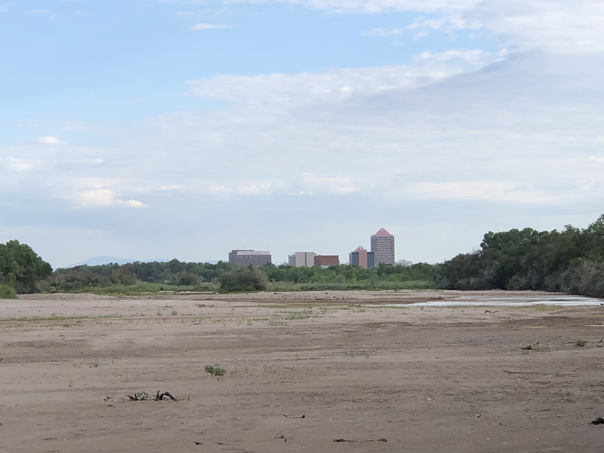
There’s so much going on in this picture.
The buildings on the horizon, downtown Albuquerque, are a couple of miles away – foreshortened by the camera’s zoom. It’s a modest downtown, which grew up in that spot 140 years ago because the real estate entrepreneurs collaborating with the newly arrived Athchison, Topeka, and Santa Fe Railway were able to get the land cheap. The spot where Albuquerque’s downtown sits today was basically a swamp.
If you look closely in the picture above, you can see a bit of water, a languid meander across the sand beds of a rapidly shrinking river. When I went out this morning (Sunday, Sept. 3, 2023) the Rio Grande through the Albuquerque reach was still “connected”, in the words of the river managers. But barely. The river that is central to this community’s creation story is about to go dry.
THE FORMALISMS OF A DYING RIVER
In the parking lot by the old Barelas Bridge this morning, I ran into one of the members of the RiverEyes team, a young person of my acquaintance who bicycles through the riverside woods, checking at regularly spaced access points to see if the river is still connected. The operation is part of the staggeringly complex social-hydrological-institutional apparatus around this stretch of the river.

The RiverEyes observations feed into the elaborate effort to stave off the extinction of a fish called the Rio Grande silvery minnow (Hybognathus amarus), which survives only in a couple hundred miles of the Rio Grande through central New Mexico. And in hatcheries. We’ve been doing RiverEyes-like monitoring since 1996. River drying is common south of town, but last year was the first time we needed to monitor here, through Albuquerque. This is the second.
On Friday, there were 30.6 miles of dry channel in the San Acacia Reach 75 miles downstream from Albuquerque. There were 3.6 dry miles in the Isleta Reach, 20 miles downstream from Albuquerque. Sampling in one of the wet parts of the San Acacia reach found 615 juvenile silvery minnows and 14 adults.
Here, we count fish.
THE “DEATH” OF “A LIVING RIVER”?
Some years ago, a consulting firm ran a series of interviews and focus groups among Albuquerque residents to try to better understand their attitudes toward the Rio Grande. They found that residents viewed water issues – their supply – as a major concern. The river, not so much.
The Rio Grande, in fact, was kind of an embarrassment to local residents, the consultant found – small and struggling, not what a “real” river is supposed to look like.
Though, to be fair, even with lots of water, the Rio Grande here looks nothing like what a “real” river is supposed to look like. In a more natural state, before we built a city here, the Rio Grande wandered a broad flood plain, five miles wide in places. The narrow 600-foot channel you see in the picture at the top is a 20th century creation, begun in the 1930s with levees, expanded in 1959 in a project the U.S. Bureau of Reclamation called “channel rectification” meant to turn a meandering river into a more efficient water delivery canal.
In response, the flood control works created ideal habitat for the development of the cottonwoods you see flanking the river, and the magnificent gallery forest we call the “bosque” grew alongside the river for most of its 200-ish miles through central New Mexico.
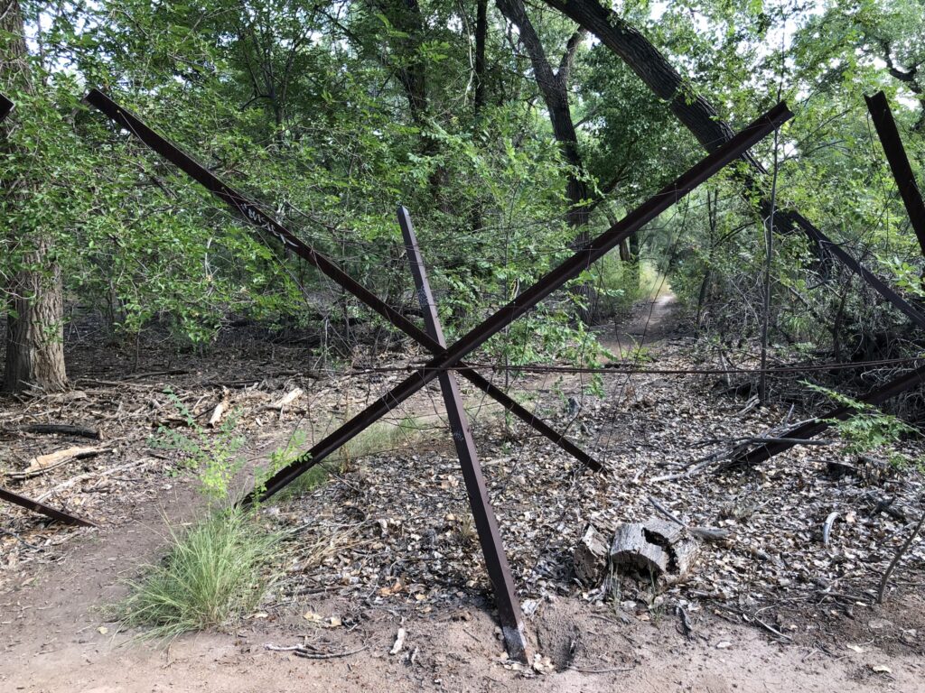
Riding this morning with a friend on a twisting path through the bosque, looking for spots to get out to the river channel to see for ourselves, we had to periodically stop and carefully navigate through “Kellner jetty jacks”, big metal contraptions installed in the ’50s as part of the “rectification” effort. Their job was to slow water and hold sediment and enhance the narrowing of the river channel. In so doing, the trapped sediments made ideal seed beds for the opportunistic cottonwoods. They also can be gnarly if you’re cycling, with cables that can snag a pedal, and sharp edges that can cut out a chunk of flesh if you’re not careful.
They also are a reminder of how profoundly unnatural this lovely natural-seeming park, which I so love, really is.
In the circles in which I spend my time, there’s a lot of talk about how to maintain a “living river” here, which is an interesting conceptual framework. Maybe it means simply continuous flowing water? But the whole system is so completely hydrologically (and therefore ecologically) altered by human interventions that we quickly end up down a deep and confusing conceptual rabbit hole when we try to think too hard about what “natural” and “living river” might mean. The terms might help us think well about desired future conditions. But they also can mislead.
THE PART ABOUT HOW IT’S GOING DRY
Weirdly, the Rio Grande is going dry this year through Albuquerque for the second time in the last four years because of a lack of plumbing. El Vado Dam on the Rio Chama, a tributary, is under repairs. Normally we’d store water from the spring runoff, using it to stretch out the river’s flows into the dry months of late summer and early fall. If we’d had El Vado storage this year, I’m told, the river would have been still flowing in the spot where I was standing to take the picture at the top of the post.
Without El Vado storage, the river here will likely dry through the lower end of the Albuquerque reach early next week. The RiverEyes team is on it. They’ll let us know.
