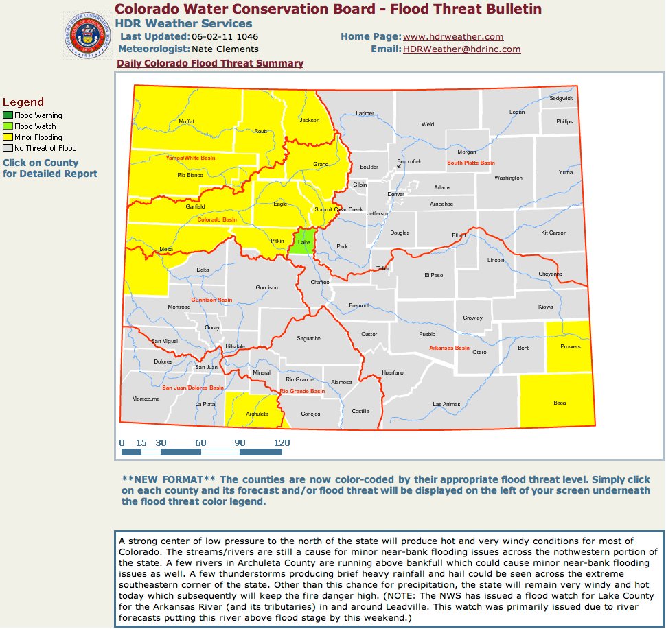
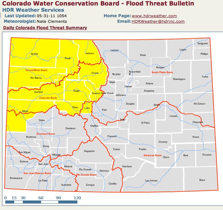
Click on the thumbnail graphic to the right for a look at this morning’s flooding picture from the CWCB. Here’s the link. Here’s the link to the Colorado Water Conservation Board’s online applications Flood DSS. Here’s the link to the USGS’ Water Watch website where you can get a graphical view of all their gages across the state. Here’s the link to the Colorado Division of Water Resources Surface Water page where you can track your favorite gages.
From the Summit Daily News (Caddie Nath):
Stream flows are still at or below average for this time of year, meaning the snow pack — which exceeded averages by up to 500 percent this year in some areas — is still up on the mountains with the heaviest runoff is yet to come. “It’s not coming off,” assistant county manager Thad Noll said. “If you look at Breck, you could still ski top to bottom. The window of melting is getting smaller. Normally we’re starting the peak runoff now (but this year) we’re not even close to getting there yet. We’re in this waiting game of, ‘we’ll see what happens.’”[…]
In Silverthorne water levels are already on the rise. A section of the Blue River trail was shut down at Bald Eagle Road underpass due to high water and will likely remain closed for the next several weeks, according to a town statement. Town officials continue to monitor the Blue River and other waterways for high water or flooding, the statement said. Breckenridge is also keeping a close eye on sections of the Blue River, assigning police patrol and even closing roads as the water rises to levels classified in three stages of ascending danger…
Frisco’s primary concern as flood season begins in force will be Tenmile Creek, though Meadow Creek on the north side of town might also be problematic.
From KJCT8.com (Don Coleman):
If you looked at the river on Wednesday afternoon, you noticed that the level had actually dropped. But, deputies warn you to stay aware. They are now predicting flood stage in Grand Junction sometime next week. “Eight hours ago, this was all snow,” Lieutenant Jim Fogg with the sheriff’s office explained as he pointed to the river. Sitting at about 11 feet, the level has dropped close to two feet over the past few days. Fogg says it is because of cold front that slowed snow melt in the mountains. “By mid-week next week, it’s going to pick up and be at flood stage.”
From 9News.com (Jeffrey Wolf/Kevin Torres):
A good chunk of Colorado could experience record levels of flooding in the next 24 to 48 hours. Areas east of the divide along the Yampa, Colorado and Poudre Rivers are at the greatest risk…
In Laporte Wednesday evening, more than 100 people gathered to discuss the issue with emergency management officials from Larimer County. “We may be looking at a minor peak here in the next few days,” Emergency Management Director Erick Nelson said. “We’re still looking at a major peak maybe on towards Father’s Day on June 20, or maybe further.”
From The Denver Post:
The weather will determine when, where or how bad flooding will be if it occurs, experts said today at a meeting of the Colorado Flood Task Force. “That is the piece of the puzzle we’re still waiting on,” said state climatologist Nolan Doesken. Hope, however, might be fleeting with a snowpack at two to three times its normal depth after weeks of storms and cooler-than-normal temperatures. “I’m really concerned if there’s a way to get rid of this much snow in a well-behaved way,” Doesken added.
A snowpack measuring site northeast of Steamboat Springs, for example, has more than 200 inches of snow containing the equivalent of 72.6 inches of water, a record for the state, according to the Natural Resources Conservation Service. The previous record at that site was 71.1 inches of water, set in 1978. The Colorado River in Garfield County already has been recorded at 1.4 feet higher than at any point last year, when the river peaked at 10.2 feet, the deepest measurement since 1984…
The Colorado River, Troublesome Creek, Muddy Creek and Willow Creek were running at or above their banks today. and low-lying areas near Kremmling are expected to flood over the next few days. The Colorado River near Kremmling was at 14 feet today, according to the U.S. Geological Survey. Flood stage is 15 feet. A flood advisory has been in effect since Tuesday for northwest Colorado. Today it was extended to 9:30 p.m. Friday. Minor flooding began Monday along the Yampa River in Steamboat Springs, inundating business parking lots along U.S. Highway 40.
From Steamboat Today (Matt Stensland):
Temperatures are getting higher and so is the water in the Yampa River, which overflowed its banks and flooded areas near the city limits on the southeastern edge of [Steamboat Springs]…
Routt County Office of Emergency Management Di r ector Bob Struble said with the forecasted high temperatures — today’s high is expected to reach 77 degrees — it’s safe to say the much anticipated melting of record amounts of snow from upper elevations finally has begun. The Tower measuring site at 10,500 feet on Buffalo Pass measured another state record Sunday with 80.1 inches of water contained in 178 inches of snow. By Tuesday, the snow water equivalent had dropped to 78.8 inches…
The Yampa was measuring 6 feet Tuesday afternoon at the Fifth Street Bridge measuring station. By early Friday morning it’s expected to reach 7.2 feet, which is above the 7-foot stage at which the Weather Service will send out flood advisories. By Sunday morning the Yampa is expected to reach 7.3 feet. The Yampa’s flood stage is 7.5 feet at the Fifth Street bridge location. The Elk River already has reached the action flood stage near its confluence with the Yampa and is expected to rise to 8.1 feet by 6 a.m. Friday. The moderate flood stage at the measuring site near Milner is 8.5 feet.
From the Summit Daily News:
The Town of Dillon is holding an informational meeting for residents on Thursday, June 2, at 5:30 p.m. at Dillon Town Hall to discuss the potential impacts of the high water spring runoff in and around Dillon and Dillon Valley, advise residents and business owners when and where sand bags will be available, discuss potential impacts regarding the planned closure of Little Beaver Trail for construction starting in summer 2011 and to sign up for email and website updates and notifications from the town regarding these issues. Town staff will be on hand to provide an update on the current situation and answer questions. For more info, contact the Town of Dillon at (970) 468-2403.
From the Delta County Independent (Hank Lohmeyer):
Streams throughout Northeast Utah and Northwest and West Central Colorado “will quickly increase to bank-full and flood levels starting the middle of this week (Wednesday),” predicted NOAA. “Flows will continue to increase through the first week of June with the potential of some rivers reaching well above flood stage,” said the NOAA forecast…
In the North Fork of the Gunnison drainage, Overland Reservoir logged 94 percent of average water content, and McClure Pass 41 percent. Snowpack water content was extremely high at some Uncompahgre River drainage gauging stations. At the Idarado station near Red Mountain, water content levels 563 percent of average were recorded Tuesday. The Red Mountain Pass station logged 206 percent of average water content, and 40 times more water content than last year during the 2010 runoff season. The Schofield Pass station and Slumgullion stations recorded 268 and 242 percent of average respectively. Ridgway Reservoir stood at 68 percent full last weekend.
From the Colorado Department of Wildlife (Randy Hampton):
The Colorado Division of Wildlife is urging anglers to take extra precautions on the water as rising temperatures and deep snowpack make for dangerous runoff conditions in the state.
State flood engineers are predicting that streams and rivers in northern Colorado could experience the highest water levels in 30 years, with the runoff season extending into early July. Flood warnings have already been posted for numerous streams and rivers in the northwest region and forecasters are warning that seasonably high temperatures this week will cause flows to ramp up quickly on both sides of the Continental Divide.
“This weekend, we expect the highest water so far this year,” said Kevin Houck, a flood engineer with the Colorado Water Conservation Board. “There may be a cooler period next week, but then it’s very likely the water will go back up and we may see a second peak that’s higher than the first.”
Area Wildlife Manager Jim Haskins of Steamboat said while stream and river angling won’t be optimal, many anglers will tempt their luck fishing streams that have spilled over their banks. With the high water, the contours of even familiar streams and rivers may not be recognizable, setting up the unwary anglers for an unexpected dunking.
“I’ve seen guys wading into shallow water step right off the bank of the stream not knowing it was there and be totally submerged,” Haskins said. “In a year like this, it pays to be extra, extra careful.”
Once in the water, even fit anglers can be quickly overmatched by the supercharged currents, cold water temperatures and submerged debris like tree trunks and shifting boulders – all of which can create life-threatening conditions.
Houck said that hydrologists predict Colorado River flows will peak at about 50,000 cubic feet per second, about 50 percent higher than last year.
Conditions are not likely to be as extreme in the southern part of the state, where snowpack is near or slightly above average in the Arkansas, San Juan and Dolores basins and right at average in the Rio Grande drainage.
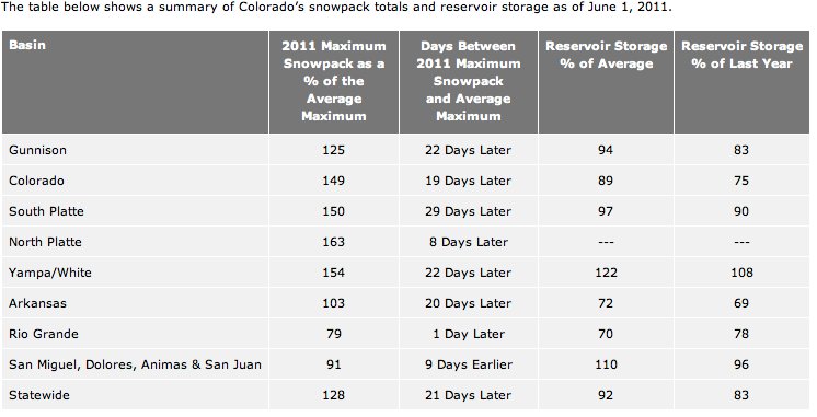
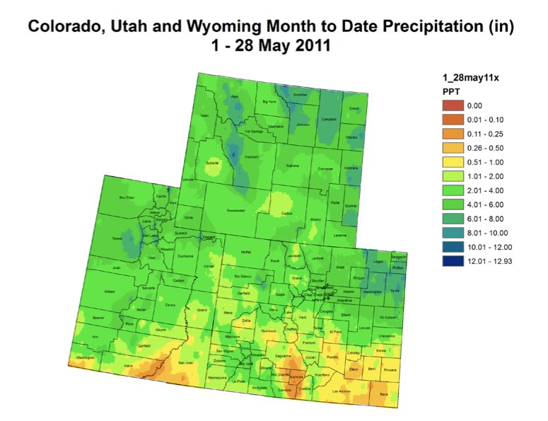
However to the north, snowpack in the South Platte basin, which waters the Denver-metro area and northeastern Colorado, is at a remarkable 323 percent of average for the date. Snowpack in the Gunnison, Yampa and Colorado River basins – all popular with anglers – ranges between 230 percent and 284 percent of average. Statewide, Colorado’s snowpack sits at 247 percent of average for the date.
Ken Kehmeier, the Northeast Region senior aquatic biologist said that the long duration of the runoff may frustrate fly-fishermen waiting for low, clear water, but flows like these are important to the long-term health of trout streams.
“These sorts of years have the ability to reinvigorate the stream channel by moving sediment, cleansing substrates, putting water and sediment into riparian areas,” Kehmeier said. “From that standpoint, these are great years to have. They’ll do good things for fish in years to come.”
From the Colorado Water Conservation Board (Kevin Houck/Tom Browning/Todd Hartman):
The Colorado Water Conservation Board encourages property owners, recreationalists, businesses and communities to pay close attention to local waterways in coming days as stream flows in many rivers within the northern portion of Colorado are quickly increasing as warmer weather enters the state.
Forecasted temperatures are on the order of ten to fifteen degrees above the seasonal average for today (June 2nd) following warm temperatures overnight. While a short cool front is anticipated to enter the state tomorrow, temperatures are expected to quickly rebound, with a sustained warm period lasting through the middle of next week. It is expected that major rivers in northern Colorado will experience their higher flows between now and June 10th.
Currently, watersheds of greatest concern west of the Continental Divide are the Yampa River, Elk River, Colorado River, and the North Platte River along with their major tributaries. Flood advisories have already been posted for Mesa, Moffat, Routt, Grand and Jackson Counties, with more expected shortly. Lake County appeared on the watch list as well. Many of these rivers are already running well above the average flows for today’s date, and many are at, or close to, bank full. East of the Continental Divide, areas of largest concern are the Cache La Poudre River, the Big Thompson River and Clear Creek. These rivers are running much lower, but may quickly climb to higher peaks when warmer temperatures melt the abundant snowpack.
A “double peak” is certainly possible this year. This would involve peak flows happening in the near future during a warm spell, then dropping off due to cooler weather, and then increasing again later in June. Although it is possible that some peak flows in rivers and streams may be on the order of levels seen in 1984 or 1995, it is important to note that the melting process is driven by the weather. Snowmelt flows are acutely affected by both high and low temperatures as well as precipitation (or the lack thereof) that falls in affected watersheds. While high water in streams that originate in Colorado’s high country is inevitable, severe damage from floods is not guaranteed.
Areas of greatest risk involve low lying lands and infrastructure adjacent to major rivers in Western Colorado and in the mountains and high foothills east of the Continental Divide. It is important to note that below about 7,500 feet east of the Divide, major floods are traditionally caused by heavy rain events, and the elevated snowmelt is unlikely to cause flooding. The primary impact to most Front Range metropolitan areas will be trail closures along streams and rivers, such as Clear Creek and Boulder Creek. The exception to this is the Cache La Poudre River in Larimer and Weld Counties, where snowmelt runoff can cause minor to moderate flooding on the plains depending on peak flows. Colorado Water Conservation Board
Residents and businesses with interests near rivers should continue to monitor water levels and contact their local emergency manager or floodplain administrator for updates. All recreationists should be aware of the dangers of high water including the potential for floating debris, unfamiliar stream banks as waters rise above known features, cold currents, and faster velocities.
The Colorado Water Conservation Board issues a Daily Flood Threat Bulletin and twice weekly 15-day Flood Outlook, which can be found at http://www.cwcb.state.co.us. A list of local emergency managers is provided by the Colorado Division of Emergency Management at http://www.coemergency.com/p/sources.html. A flood Decision Support System is also available to the public at http://flooddss.state.co.us/Default.aspx