The Colorado Wildlife Commission Thursday endorsed Fish and Wildlife Mitigation Plans submitted by Denver Water and the Northern Colorado Water Conservancy District to mitigate impacts that would be caused by two proposed transmountain water development projects.
In a series of unanimous votes, Commissioners approved mitigation plans for Denver’s Moffat Collection System project and Northern’s Windy Gap Firming Project and also authorized the Division of Wildlife to enter into an intergovernmental agreement with Denver and Northern to help manage a significant restoration project for the upper Colorado River. Three members of the Colorado State Parks Board joined the Commission at the workshop, which was held at the Doubletree Inn on Horizon Drive.
The votes came after Denver and Northern described to Commissioners several new or modified plan elements, which include enhanced temperature and flow protections, creation of contingency funds for unanticipated impacts and enhanced funding for river restoration plans. The restoration plans were not required by the permitting process but were offered voluntarily by Denver and Northern to help address impacts from past water development. The agreements hinge on the water providers obtaining final federal approval for their projects.
Prior to the vote, Wildlife Commission chairman Tim Glenn summarized concerns expressed by several commissioners regarding the complex package of plans and the potential that development of the projects may have unintended consequences for the upper Colorado, Fraser and Williams Fork rivers.
“Is it perfect?” Glenn asked “No. But staff has evaluated it inside and out and I’m confident that it’s better than where we are.”
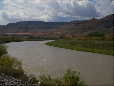
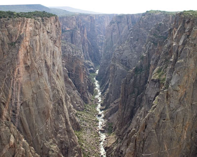
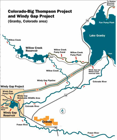
The Commission’s recommendation will now be transmitted to the federal permitting agency for each project. Denver Water’s Moffat Collection System project would firm up the yield from Denver’s existing water rights on the West Slope, primarily by enlarging Boulder’s Gross Reservoir and diverting additional water from the Fraser, Williams Fork and Blue rivers. Northern’s Windy Gap Firming Project proposes to firm up the yield from its existing water rights in the Upper Colorado River by diverting additional water to the proposed new Chimney Hollow Reservoir west of Loveland.
Since last fall, Denver and Northern have been in discussions with Division of Wildlife staff to address concerns voiced by the public and by Wildlife Commissioners. The two utilities have simultaneously been negotiating a complimentary set of agreements with a diverse group of stakeholders, including affected local governments like Grand County.
To further address impacts from its Moffat Collection System project, Denver has agreed to new elements including increased safeguards for maintaining cool water temperatures and minimum flows in the Fraser during high summer and additional funds for aquatic habitat improvements in that river. Denver also agreed to reserve $600,000 for a “mitigation insurance policy” to address any new impacts identified by the Final Environmental Impact Statement being developed by the Army Corps of Engineers.
This is in addition to Denver’s previous proposal to fund a Colorado River cutthroat restoration project and other aquatic habitat restoration work on the Fraser. On the Colorado River, Denver would maintain two water temperature gauges and agree to release water in August if high temperatures threatened fish. East of the Divide, Denver would allow Boulder and Lafayette to store water in the enlarged Gross Reservoir for release during winter months, replace wetlands inundated by the larger reservoir and monitor stream channel stability.
In its final proposal, Northern agreed to increase minimum peak flows during drought conditions to maintain fish spawning habitat, to further restrict or curtail pumping during extreme conditions to protect cool water temperatures and to reserve $600,000 for a “mitigation insurance policy” to address any new impacts identified by the Final Environmental Impact Statement for Windy Gap being developed by the Bureau of Reclamation.
Northern’s proposal included mitigating impacts on the Upper Colorado River system by managing their pumping to maintain water levels in Lake Granby and keep water temperatures cool, looking for ways to improve flushing flows in the Upper Colorado River below Windy Gap Reservoir and contributing to water quality projects that reduce nutrient loading in Lake Granby, Grand Lake and Shadow Mountain Reservoir. East of the Divide, Northern proposed to replace lost wetlands and improve enhance wildlife habitat near the new Chimney Hollow reservoir.
Under state statute, the Wildlife Commission’s authority was limited to mitigating impacts from proposed projects. Restoring the river to a past condition was beyond the scope of Commission authority. However, Denver and Northern voluntarily proposed to help enhance conditions for fish and wildlife resources on both sides of the Continental Divide.
The enhancement plans would support the Upper Colorado River Habitat Project, a collaborative plan designed to re-establish a functional channel system and improve habitat for trout and other important aquatic species on a roughly 14-mile stretch of river between Windy Gap Reservoir and the Kemp-Breeze State Wildlife Area.
In their final plans, Denver and Northern agreed to add $1 million in funding to the Upper Colorado River Habitat Project to $4.5 million and increase money set aside to address future contingencies or operating and maintenance costs on that project to $1.5 million. Denver and Northern also pledged to enter into an intergovernmental agreement with the DOW to manage the habitat project, and urged that the DOW be given a more direct role in developing and managing stream restoration projects contemplated under the Learn By Doing adaptive management process created by Denver’s global settlement with Grand County and other stakeholders.
That global settlement, announced recently by Denver Water, would address longstanding concerns about the health of the Colorado River. The settlement includes funding for aquatic habitat and for an adaptive management process designed to help maintain river health.
Northern is also working on similar agreement with communities on the Upper Colorado River.
Senior Northeast Region aquatic biologist Ken Kehmeier said Division staff believes that in total, the agreements, including those made with mountain communities, would not only address impacts from the new projects but also help repair impacts to the Colorado and Fraser rivers caused by previous projects.
Commissioner David Brougham credited the Division, Denver and Northern for negotiating agreements which went beyond the Commission’s limited jurisdiction under the statute.
“I think in looking at this the Division has gone beyond and done more than that statute gives us the power to do,” Brougham said. “Denver and Northern could have said no, but they didn’t and I think that’s telling.”
Additional information regarding the Wildlife Commission’s review, including links to the mitigation and enhancement plans being offered by Denver Water and Northern, can be found on the Division’s web site at: http://wildlife.state.co.us/LandWater/Water/MoffatWindyGapMitigationProjects/.
During the morning session, North Park District Wildlife Manager Josh Dilley was presented with the 2010 Shikar-Safari Club International Officer of the Year Award. Dilley, who for the past three years has had responsibility for two wildlife management districts in the high mountain basin, was presented with the award by Bob Boswell of Shikar Safari Club International.
Dilley, who was surrounded by his family, said he was honored by the award. “I don’t have to go to work every morning, I get to go to work every morning,” Dilley told the Commissioners. “Wildlife officers in Colorado have a passion like no other. I work with my heroes every day.”
Grand Junction’s Lynn Ensley, who founded the nonprofit Pathways for Fishing, was recognized for his outstanding service in recruiting young anglers in Colorado. “I can’t say enough about Lynn’s continued dedication, his passion and his enthusiasm,” said Northwest Regional Manager Ron Velarde. “Since 1995, Lynn has introduced almost 15,000 kids to the sport of fishing.”
Ensley expressed to the Commissioners his appreciation for the Division’s support over the years, adding that he is looking to develop a new program to recruit young deer hunters.
Commissioners also received an update on draft black bear management plans for the northern Front Range, the Sangre de Cristos, the Uncompahgre and the Bears’ Ears area of northwestern Colorado, as well as an update on the impending July 1 merger of the Division of Wildlife with Colorado State Parks.
In other action, the Commission adopted final regulations removing bag and possession limits at Bonny Reservoir State Park and allow the use of trotlines and jugs. This action permanently implements an emergency regulation passed by the Commission at its last meeting in May 2011. Bonny Reservoir is scheduled to be drained in the fall of 2011, and this change is intended to allow the public to use all game fish prior to the draining of the reservoir.
The Wildlife Commission meets monthly and travels to communities around the state to facilitate public participation in its processes. The complete agenda for the June Wildlife Commission meeting can be found on the Wildlife Commission web page at:
http://wildlife.state.co.us/WildlifeCommission/Archives/2011/June92011.htm.
The Colorado Wildlife Commission is an 11-member board appointed by the governor. The Wildlife Commission sets Division of Wildlife regulations and policies for hunting, fishing, watchable wildlife, nongame, threatened and endangered species. The Commission also oversees Division of Wildlife land purchases and property regulations.


