The Lower Arkansas Valley Water Conservancy District has contracted with the Pueblo Board of Water Works for a five year augmentation plan supply

lowerarkansasriver.jpg

From The Pueblo Chieftain (Chris Woodka):

The Lower Arkansas Valley Water Conservancy District will buy 500 acre-feet of water from the Pueblo Board of Water Works each year for the next five years under the lease agreement. The Lower Ark board approved the lease Wednesday, while the Pueblo water board is expected to consider it in November. The price is $196.54 per acre-foot, the same rate as paid by Two Rivers, which is using the water in its project to restore agriculture on the Huerfano-Cucharas Ditch in Pueblo County…

The water is needed to fill augmentation needs calculated under the district’s group plan that allows farmers to comply with state rules adopted last year. The district has other water resources, but some are dedicated to other purposes. The Pueblo water board, in nearly every year, has surplus water available for leases and has the option to curtail the deliveries if supplies run short. “We want to make sure we have a reliable supply of water for the Rule 10 plan,” said Jay Winner, general manager of the Lower Ark district.

State Engineer Dick Wolfe successfully guided the rules through Water Court to ensure that improvements such as large irrigation sprinklers, drip irrigation and canal lining did not increase consumptive use. Increasing consumptive use would decrease return flows used by ditches downstream and possibly reduce Arkansas River flows at the Kansas state line…

Rule 10 allows farmers to join a group plan rather than go through more costly engineering on individual systems. The Division 2 engineer’s office developed a model that assures compliance with the formula governing well augmentation under the federal lawsuit. More than 70 wells signed up for the Rule 10 plan under this year, its first year. More are expected next year. Lower Ark has the only group plan in the Arkansas Valley…

Water Division 2 Engineer Steve Witte said six owners of 10 irrigation sprinklers were issued notices of violation of the rules this year. One of those proved the sprinkler was installed prior to 1999, and thus exempt; one is in appeal; and the rest are apparently joining the Rule 10 plan.

More Arkansas Valley consumptive use rules coverage here and here.

Centennial: The League of Women Voters of Araphoe County and the Arapahoe County Library are collaborating on a hydraulic fracturing public forum on November 2

niobrarashale.jpg

Here’s the release from the League of Women Voters via the Englewood Herald:

Explore the issues and find answers to your questions about the practice of fracking (hydraulic fracturing), a method used to release trapped gas and oil from the land, at a public forum Nov. 2 at 6:30 p.m. at Koelbel Public Library, 5955 S. Holly St., Centennial.

Sponsored by the League of Women Voters of Arapahoe County and the Arapahoe Library District, the forum will feature David Neslin, Director of the Colorado Oil and Gas Conservation Commission, Bryon Gale, Vice President, Environmental Health and Safety, Encana Oil & Gas (USA), and Charlie Montgomery, Energy Organizer, Colorado Environmental Coalition.
Topics will include:

What is fracking and where, when and why is it used in Colorado?

What are the potential problems and environmental consequences that may arise from fracking operations?

What operational and design safeguards are being used to avoid these problems?

What are the current rules regarding fracking and do we need regulations that are more stringent?

The program is free and open to the public, but registration is required. Call the Arapahoe Library District, 303-542-7279. For information about the forum call 303-798-2939.

More oil and gas coverage here and here.

U.S. District Judge William Martinez orders halt to the DOE approval of exploration, mining and all other activities on 31 leases in southwestern Colorado

doloresrivercanyon.jpg

From The Denver Post (Bruce Finley):

U.S. District Judge William Martinez ordered DOE officials to stop approving exploration, mining and all other activities on 31 sites leased to uranium companies. The ruling affects about 25,000 acres southwest of Grand Junction along the Dolores and San Miguel rivers. A 53-page opinion filed late Tuesday said the DOE “acted arbitrarily and capriciously in failing to analyze site-specific impacts” on people and the environment — especially given the history of uranium mining in the region. Martinez also found DOE officials violated the Endangered Species Act by failing to consult with U.S. Fish and Wildlife Service biologists about the impact of leasing uranium lands.

The decision means federal overseers of the nation’s push to develop fuel for nuclear energy must proceed far more carefully and conduct a detailed analysis — with full public participation — of the likely effects that renewed uranium mining and milling would have on air, land, water and people…

State health regulators this year issued a final permit, which local residents are challenging in court. The mill proposal led to several companies expressing interest in mining uranium. DOE officials responded by reconfiguring lease tracts in 2007, then issuing leases for 31 tracts in 2008 to six companies — Cotter Corp., Golden Eagle Uranium, Energy Fuels Resources, Gold Eagle Mining, U.S. Uranium Corp. and Zenith Minerals. The DOE has estimated 13.5 million pounds of uranium ore could be extracted and began approving exploration plans on five lease tracts in 2009…

It is unclear whether the agency will appeal the judge’s decision, said Laura Kilpatrick, manager of the DOE Office of Legacy Management’s uranium leasing program.

More coverage from Bob Berwyn writing for the Summit County Citizens Voice. From the article:

The court ruled that the U.S. Department of Energy acted arbitrarily and capriciously” by failing to analyze site-specific impacts when it approved a leasing program on 42 square miles of federal land in Mesa, Montrose and San Miguel counties. The Energy Department approved the leasing program under an environmental assessment, concluding with a formal “Finding of No Significant Impact.” A coalition of environmental groups challenged the approval and asked the court to order an in-depth environmental impact statement based on the potential for the mining and related activities to significantly affect the quality of the human environment. Judge Martinez declined to go that far, instead remanding the decision back to the energy department with orders to conduct a study that considers site-specific impacts. According to the ruling, the Energy Department has indicated it will do a complete environmental impact statement…

Conservation groups called this week’s decision a major victory for clean air, clean water and endangered species on public lands. “We are pleased that Judge Martinez agreed with the groups, as well as local governments, who have been requesting the federal government take responsible steps to disclose the full range of impacts of mining uranium on public lands in combination with the impacts from Energy Fuels’ proposed uranium mill,” said Hilary White, executive director of Sheep Mountain Alliance…

The Colorado Environmental Coalition, Information Network for Responsible Mining, Rocky Mountain Wild, Center for Biological Diversity and Sheep Mountain Alliance sued the Department of Energy and Bureau of Land Management in July 2008 for approving the program without analyzing the full environmental impacts from individual uranium-mining leases across more than 20,000 acres, and for failing to ensure protection of threatened and endangered species before authorizing the program. Plaintiffs were represented by attorneys Travis Stills of the Energy Minerals Law Center, Jeff Parsons of the Western Mining Action Project and Amy Atwood of the Center for Biological Diversity.

Update: From The Grand Junction Daily Sentinel (Dennis Webb):

A federal judge on Tuesday suspended a 42-square-mile federal uranium-leasing program in southwestern Colorado over concerns potential environmental impacts have not been adequately considered. The ruling was made in response to a lawsuit brought by five conservation groups that sought to halt the Department of Energy’s leasing program, which they say threatens the Dolores and San Miguel rivers.

Here’s the release from the Center of Biological Diversity (Taylor McKinnon), The Sheep Mountain Alliance (Hillary White) and Rocky Mountain Wild (Josh Pollack):

In a major victory for clean air, clean water and endangered species on public lands, a federal judge on Tuesday halted the Department of Energy’s 42-square-mile uranium-leasing program that threatened the Dolores and San Miguel rivers in southwestern Colorado. Five conservation groups had sued to halt the leasing program, charging that the Department of Energy was failing to adequately protect the environment or analyze the full impacts of renewed uranium mining on public lands.

“We are pleased that Judge Martinez agreed with the groups, as well as local governments, who have been requesting the federal government take responsible steps to disclose the full range of impacts of mining uranium on public lands in combination with the impacts from Energy Fuels’ proposed uranium mill,” said Hilary White, executive director of Sheep Mountain Alliance. “This is an important ruling that will help ensure that any uranium mining and milling that may take place in the Dolores River watershed is protective of the environment and human health. We look forward to the Environmental Protection Agency’s leadership in disclosing the full impacts of uranium activity in this important watershed.”

The 53-page ruling invalidates the Department’s approval of the program; suspends each of the program’s 31 existing leases; enjoins the Department from issuing any new leases; and enjoins any further exploration, drilling or mining activity at all 43 mines approved under the program pending satisfactory completion of new environmental reviews under the National Environmental Policy Act and Endangered Species Act.

“This is a huge victory for public lands, rivers and wildlife in southwestern Colorado and a major setback for the uranium industry’s efforts to industrialize and pollute the Colorado Plateau,” said Taylor McKinnon, public-lands campaigns director at the Center for Biological Diversity. “The Department of Energy has thumbed its nose at environmental laws for too long; today’s ruling is a big course correction.”

Conservation groups challenged the Department’s current leasing program for not complying with the National Environmental Policy Act and Endangered Species Act. In July the Department attempted to thwart the lawsuit by initiating a new “environmental impact statement” for the program but continued to administer the program under its prior flawed approval.

Uranium mining and milling resulting from the lease program will deplete Colorado River basin water and threaten to pollute rivers with uranium, selenium, ammonia, arsenic, molybdenum, aluminum, barium, copper, iron, lead, manganese, vanadium and zinc. Selenium and arsenic contamination in the Colorado River basin from abandoned uranium-mining operations have been implicated in the decline of four endangered Colorado River fish species and may be impeding their recovery.

“Even small amounts of some of these pollutants, like selenium, can poison fish, accumulate in the food chain and cause deformities and reproductive problems for endangered fish, ducks, river otters and eagles,” said Josh Pollock of Rocky Mountain Wild. “It is irresponsible for the Department of Energy to put fish and wildlife at risk by allowing uranium leases without adequate analysis of necessary protections to prevent pollution.”

The Colorado Environmental Coalition, Information Network for Responsible Mining, Rocky Mountain Wild, Center for Biological Diversity and Sheep Mountain Alliance sued the Department of Energy and Bureau of Land Management in July 2008 for approving the program without analyzing the full environmental impacts from individual uranium-mining leases spread over 20,000 acres and for failing to ensure protection of threatened and endangered species prior to authorizing the program. The Department refused to conduct a full EIS analysis in 2008, instead issuing a FONSI (“finding of no significant impact”), which was also struck down as part of the court ruling.

Plaintiffs were represented by attorneys Travis Stills of the Energy Minerals Law Center, Jeff Parsons of the Western Mining Action Project and Amy Atwood of the Center for Biological Diversity.

Download a copy of the ruling here.

More nuclear coverage here and here.

Lamar pipeline: The Lower Ark Board listened politely (and critically) to GP Resources’ project preview yesterday

denverbasinwellsandpumping.jpg

From The Pueblo Chieftain (Chris Woodka):

The board had questions about the projected yield of the project, the problem of brine disposal from a proposed treatment plant and the idea of moving water out of the Arkansas Valley — which goes against the mission adopted by the district after voters formed it in 2002. “I compliment your approach, opposed as I am to any water leaving the valley,” said Reeves Brown, a Beulah rancher who sits on the Lower Ark board. “There’s a limit to what we think agriculture can give up in order to support growth in Colorado.”[…]

Upon questioning from the Lower Ark board, Nyquist said the only definite use for the water is in Elbert County. The Cherokee Metro District in Colorado Springs and Castle Rock in Douglas County have been approached, but decided on other options, at least in the short term, Nyquist said. “Right now, the pipeline ends at Falcon,” Nyquist said.

“It’s only a short distance to Reuter-Hess Reservoir (in Parker), which has 60,000 acre-feet of empty storage space,” said Jay Winner, general manager of the Lower Ark district…

GP is looking at either deep injection of brine or a solar heating system that would evaporate the water [ed. by-product of the proposed reverse osmosis water treatment plant]. The heating system, which could also generate steam to power turbines, has not been tested on a large scale, Nyquist said. It would also generate 16 truckloads of salt per week. “It could be used as sidewalk deicer,” Nyquist said. “As a private business, we will figure out another manufacturing opportunity for something that would just be waste.”[…]

[Karl Nyquist] said the assessed valuation of the ground on which the treatment plant is built would be greater than the value of the ground dried up. The combined wages from jobs at the treatment plant, reservoir and continued farm operations would more than make up for the temporary farm jobs that would be lost as a result of the dry-up, Nyquist said.

More Lamar pipeline coverage here.

The Bureau of Reclamation is evaluating alternatives for the Arkansas Valley Conduit, the draft EIS should be out in 2012

arkansasvalleyconduitproposed.jpg

From The Pueblo Chieftain (Chris Woodka):

“This is a big step, and I’m thankful we’ve made it to this point,” said Bill Long, president of the Southeastern Colorado Water Conservancy District, sponsors of the conduit. “I’m optimistic that we’ll be able to meet the timelines.” Those timelines include completion of the draft EIS by next fall and construction of the 235-mile pipeline within a decade…

Wednesday’s session dug down into how the EIS will be developed and explained over the next year. Reclamation is attempting to make the process more understandable to the general public. “We’re trying to make it a much more readable document for the general public,” said Jerry Gibbens, a consultant for MWH Engineering.

The conduit will move about 10,000 acre-feet of water annually, and will be associated with a master contract for about 26,900 acre-feet of storage in Lake Pueblo. Together the projects involve about 20 percent of the municipal water supply, and 7 percent of the total water supply, Gibbens said. The impact throughout the Arkansas River basin, and particularly downstream from Pueblo Dam, will be studied. To help the public get a better idea, photographs of how the river looks at various stages along different reaches of the rivers will be included along with the traditional hygrograph in the online version of the draft EIS, once it is completed, Gibbens said.

More Arkansas Valley Conduit coverage here and here.

Public Invited to Open Houses on Plan for Glen Canyon Dam Operations

glencanyondam030508.jpg

Here’s the release from the National Park Service (Barry Wirth/Maureen Oltrogge):

Public Invited to Open Houses on Plan for Glen Canyon Dam Operations

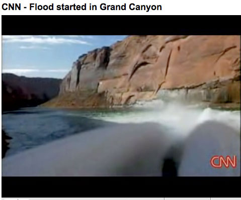
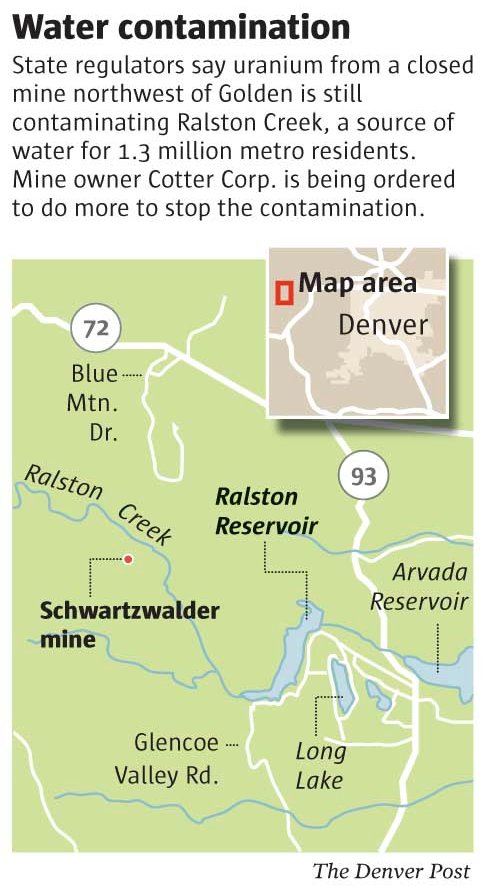
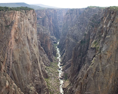
Beginning Nov. 7, the public will have an opportunity to attend public meetings on the development of a long-term plan that will determine the timing and volume of water flows from Glen Canyon Dam. Those flows affect hydroelectricity production, beach recreation, native fish and other river-related plants and animals, as well as archeological sites in Grand Canyon National Park and Glen Canyon National Recreation Area.

The long-term plan will address routine operations as well as “experimental” flows that provide additional scientific information about how to protect endangered fish and lessen the effects of dam operations on downstream ecology and other resources. The plan will ensure that regulated flows on the Colorado River meet the goals of supplying hydroelectricity and water for communities, agriculture and industry at the same time they protect the ecologies of the Grand Canyon and Glen Canyon.

The meetings, to be held jointly by the Bureau of Reclamation and the National Park Service, will take place in:

– Phoenix, Arizona: Monday, November 7, 2011, 6 to 8 p.m., Sheraton Crescent Hotel, 2620 W. Dunlap Avenue, Phoenix, AZ 85201.

– Flagstaff, Arizona: Tuesday, November 8, 2011, 6 to 8 p.m., Radisson Woodlands Hotel Flagstaff, 1175 W. Route 66, Flagstaff, AZ 86001.

– Page, Arizona: Wednesday, November 9, 2011, 6 to 8 p.m., Courtyard Page at Lake Powell, 600 Clubhouse Drive, Page, AZ 86040.

– Salt Lake City, Utah: Tuesday, November 15, 2011, 6 to 8 p.m., Hilton Salt Lake City Center, 255 South West Temple, Salt Lake City, UT 84101.

– Las Vegas, Nevada: Wednesday, November 16, 2011, 6 to 8 p.m., Ramada Las Vegas, 325 East Flamingo Road, Las Vegas, NV 89169.

– Lakewood, Colorado: Thursday, November 17, 2011, 6 to 8 p.m., Sheraton Denver West Hotel, 360 Union Boulevard, Lakewood, CO 80228.

– Web-based meeting: Tuesday, November 15, 2011, 1 to 3 p.m. Mountain Time. For specific information about the web-based meeting and how to participate, please refer to the project website at: http://ltempeis.anl.gov.

Work on the new plan, known as the Long-Term Experimental and Management Plan (LTEMP), is the first comprehensive review of Glen Canyon Dam operations in 15 years. The purpose of the LTEMP is to use current and newly developed science to improve and protect resources of Glen Canyon National Recreation Area, Grand Canyon National Park, and Lake Mead National Recreation Area while also complying with the Law of the River, the 1992 Grand Canyon Protection Act, the Endangered Species Act, and other applicable laws.The LTEMP process will determine the need for future modifications to Glen Canyon Dam operations, and whether to establish an Endangered Species Act Recovery Implementation Program for endangered fish species below Glen Canyon Dam.

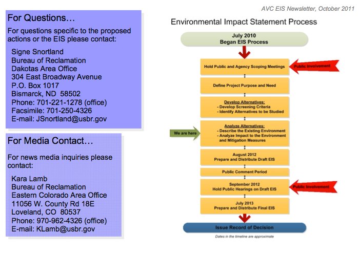
Changes to dam operations and other actions taken by the Department of the Interior (DOI) will be evaluated as “alternatives” in an Environmental Impact Statement (EIS). The EIS will document and evaluate impacts of the alternatives.

The public meetings announced today are part of the “public scoping” phase of the National Environmental Policy Act (NEPA) process. Public scoping gives interested individuals and groups the opportunity to comment on a proposed action, recommend alternatives, and to identify and prioritize the issues to be considered in the EIS analyses. Scoping is the earliest, but not the last, opportunity for people to provide input on the Glen Canyon Dam LTEMP EIS.

Each public scoping meeting will include a welcome and project overview session (15 minutes) and opportunities for the public to review exhibits, informally discuss issues, and ask questions of technical experts and managers.

More information on the meetings will be announced through local media, newsletters, and the project web site: http://ltempeis.anl.gov.

The public can submit comments by the following methods:

Website: http://ltempeis.anl.gov. (the preferred method)
Mail: Glen Canyon LTEMP EIS Scoping, Argonne National Laboratory, EVS/240, 9700 S. Cass Avenue, Argonne, IL 60439.

Reclamation and the NPS will accept comments that are received or postmarked by Friday, Dec. 30, 2011.

To have your name added to the mailing list for future information, visit the Glen Canyon LTEMP EIS website listed below or contact Beverley Heffernan, Bureau of Reclamation, Upper Colorado Region, Attention: UC-700, 125 South State Street, Salt Lake City, UT 84138-1147; facsimile (801) 524-3826.

Additional information, including a full copy of the Notice of Intent published yesterday in the Federal Register is available at the project web site: http://ltempeis.anl.gov.

More Colorado River basin coverage here.

CWCB: The City of Trinidad has applied for a loan to help offset the cost of the North Lake Dam rehabilitation project

spanishpeaks.jpg

From The Trinidad Times (Steve Block):

The Arkansas Basin Roundtable filed a $739,000 request for funds derived from a mineral severance tax levied to enhance the state’s ability to bring water to urban areas. The roundtable will contribute $50,000 to the project.

The state engineer’s office recently mandated the water level in the lake, Trinidad’s primary water source, be reduced by five feet to relieve pressure on the dam 30 miles west of the city.

Jim Fernandez, city utility superintendent and roundtable board member said the dam has been leaking for several years and that the board’s approval for a grant request was a lengthy process. “We’re making progress and that’s always a good thing,” Fernandez said. “It took a long time before this request came before the board…

The existing dam will be reinforced with massive amounts of soil from a nearby borrow pit and the spillway will also be rebuilt. The city has spent $847,000 to design and build a new concrete outlet works and drain system and committed $389,000 to the project. Trinidad has applied for a low-interest construction loan of $739,000 with the state water conservancy board.

Using the dam to produce hydroelectric power is under consideration by the city engineering department. Fernandez said there isn’t much water flow at the lake in the winter, making consistent power generation a potential problem.

More Arkansas River basin coverage here.

The Castle Pines Metropolitan District nixes participation in the WISE project

denveraquifer.jpg

From the Aurora Sentinel (Sara Castellanos):

In a letter sent Oct. 12 from Paul Dannels, district manager of the Castle Pines Metropolitan District, to Rod Kuharich, executive director of the [South Metro Water Supply Augthority], Dannels said the board of directors decided not to proceed with the project. “Simply stated, the high cost of the Project and the uncertainty of water delivery do not make sense for the District at this time,” Dannels wrote in the letter. “We wish you great success with the Project which appears more feasible for larger users. They can deal better with both the uncertainty of water availability and the high Project costs than smaller users such as the District.”[…]

Greg Baker, spokesman for Aurora Water said the project, dubbed the Water Infrastructure and Supply Efficiency partnership, doesn’t require that all 15 entities of the SMWSA take deliveries for the project to be successful. Roxborough and the East Cherry Creek Valley Water and Sanitation District have already indicated that they had other resources they could develop and wouldn’t take water from the WISE partnership, Baker said. “Each member of the SMWSA must assess the value of participation in relation to their individual systems and needs,” Baker said. “SMWSA has indicated that the commitments from many of the other members have already met or exceeded the initial 10,000 acre-feet provided for by the proposed delivery agreement.”

More Water Infrastructure and Supply Efficiency partnership coverage here.

McPhee Reservoir water year 2011 report: The Dolores Water Conservancy District’s 50th anniversary celebration will be November 12 in Dolores

mcpheereservoiroverlook.jpg

From the Cortez Journal (Reid Wright):

“We’re in as good of shape as we have ever been,” [Dolores Water Conservancy District] Manager Mike Preston said. “We had 63 percent of active capacity in the reservoir. And that means that we’re carrying a good supply for next year.”

After a relatively dry winter, spring precipitation arrived later than usual, resulting in a full reservoir and prolonged dam spill for recreational boating on the Lower Dolores River. After the spill, a hot and dry summer resulted in heavy irrigation, Preston said, which was alleviated at the end of the irrigation season by fall storms.

As of Wednesday, the McPhee Reservoir stood at an elevation of 6,903.6 feet with an active capacity of 145,045 acre feet of water. The reservoir has a 229,182 acre foot maximum active capacity…

Meanwhile, the U.S. Bureau of Reclamation released the September-end status of Jackson Gulch Jackson Gulch reservoir, which serves Mancos and the surrounding area, at a live content of 3,938 acre-feet with a 9,977 acre-feet maximum capacity and a 4,576 acre-feet average (1971-2000) end-of-month content. At Jackson Gulch, a daily maximum/minimum of 43/0 cubic-feet-per second was released into the Mancos River, and 29 acre-feet were released for municipal purposes.

This year marks DWCD’s 50th year in operation. The public is invited to a celebration scheduled for 12 p.m. Nov. 12 at the Dolores Community Center, 400 Riverside Avenue in Dolores. Call 565-7562 to RSVP.

More Dolores River watershed coverage here and here.

Denver: ‘Charting New Waters’ sponsors hear from state water officials about how Colorado is dealing water and growth issues

wetlandssouthplatte.jpg

From The Pueblo Chieftain (Chris Woodka):

The Johnson Foundation at Wingspread hosted a meeting attended by top state water officials at the Denver Botanical Gardens in an effort to learn how Colorado is dealing with water and growth issues. “We wanted to learn about some things that are working well in Colorado to inform a national population dealing with water issues, perhaps not in the same way,” said Lynn Broaddus, environmental program director for the foundation…

Charting New Waters stressed water conservation, sharing water and watershed protection as major strategies toward meeting the needs of growth with a reliable fresh water supply.

Speakers at Tuesday’s meeting included representatives from the Family Farm Alliance, Farm Bureau, Colorado Water Conservation Board, Denver Water and Aurora. Water managers and advocates from other states also spoke. More than 100 attended the meeting.

“I think they’re having a conversation about what we can do about water and population growth, and it’s a great opportunity for people from other states to compare notes,” said John Stulp, IBCC chairman and Gov. John Hickenlooper’s water policy adviser. “I think their goal is to provide leadership and not wait for a crisis to happen.”

2012 Colorado legislation: Proposal to mandate water saving toilets defeated in the Water Resources Committee along party lines

waterefficenttoilet.jpg

From The Pueblo Chieftain (Patrick Malone):

Rep. Keith Swerdfeger, R-Pueblo West, joined fellow Republicans in their reluctance to support a government-mandated type of toilet. He said conversations with a representative of the Pueblo Regional Building Department led to other objections. Swerdfeger said he has no doubts that toilets with 1.28-gallon flush capacities are basically as effective as the 1.6-gallon models that are the present flow limit, but he worries that the lower flow would not sufficiently move solid waste through below-ground sewer lines.

“The technology’s good, the intent is good, but we also have some unintended consequences below the toilet,” Swerdfeger said. He expressed concern that costly, premature replacement of sewer lines could result.

“We have some research that really disputes that,” said Sen. Angela Giron, D-Pueblo…

She said Republicans ignored the work of the Interbasin Compact Commission, which last year — after years of development — released a far-reaching strategy aimed at meeting the state’s agricultural and urban water demands in the future. The commission’s recommendations included elements as basic as low-flow toilets and water-conserving shower fixtures and as ambitious as massive water storage projects…

Jay Winner of Pueblo, who serves as the Arkansas River basin’s representative on the IBCC, shared Giron’s frustration. Resistance from Republican lawmakers who represent agricultural areas baffled him. He said the 20,000 acre-feet of water that the measure is estimated to conserve is that much less that will be available for agricultural use.

Winner characterized the Republican opposition to the toilet restriction as dismissive of the IBCC’s work and recommendations. “Toilets are an easy step toward conservation. What happens when we bring a tough project like storage forward?” Winner said. “Is this just a waste of time for the IBCC? This vote does not give the IBCC a vote of confidence. I think it’s a blow to the IBCC.”

More coverage from Joe Hanel writing for The Durango Herald. From the article:

The panel shot down two bills Tuesday that sought water savings from toilets. Republicans expressed concerns about increased regulations and the effects on rural communities that depend on generous flushing from Front Range cities to fill eastern Colorado rivers.

The vote was a setback for the Interbasin Compact Committee, a group the Legislature created in 2005 to find a peaceful solution to the state’s West vs. East water wars. The IBCC last year endorsed strict statewide plumbing standards for a variety of appliances. The bill that failed Tuesday focused only on toilets, setting a 1.28 gallons-per-flush standard for new toilets sold in stores, tighter than the national standard of 1.6 gallons.

IBCC member Taylor Hawes urged legislators to vote “yes” to send the IBCC a message that its work matters, especially because the panel is proposing other options that are even more politically unpalatable. “This is the easy path. We have much, much harder choices in front of us,” Hawes said.

The bill failed on a 5-5, party-line vote Tuesday in the Water Resources Review Committee, with only Democrats supporting it. Had the bill succeeded, it would have received a powerful endorsement from the committee in January, when the Legislature begins its 2012 session…

The committee also turned down a bill to allow people to use “graywater” – domestic water that already has been used once in the house – for toilet flushing. [Sen. Ellen Roberts] sided with Democrats and voted for the bill, but the 6-4 tally was short of the supermajority the bill needed to get the water committee’s endorsement.

More 2012 Colorado legislation coverage here.

Colorado-Big Thompson Project update: Reclamation is gearing up for fall maintenance

coloradobigthompsonmap.jpg

From email from Reclamation (Kara Lamb):

Now that it is fall, we are into our annual maintenance schedule on the east slope of the Colorado-Big Thompson Project. That means there will be some changes across our reservoirs and canals.

The first update is actually a schedule change at Pinewood Reservoir. Previously, I had let you all know that Pinewood was going to be drawn down considerably in November. That is no longer the case. With the changes in place, Pinewood will now be full by October 28 and stay relatively high until the week of Thanksgiving. During that week, testing at the Flatiron power plant below will begin and the water level at Pinewood will slowly drop for about three weeks. At this time, we are anticipating the water level at Pinewood will start going back up in the middle of December.

While the test is going on at Flatiron, the contractor will be busy on the Pole Hill Canal box culvert project. With Pole Hill, Pinewood, and Flatiron under maintenance, it is very likely we will wind up running some water down the Big Thompson Canyon, releasing from Olympus Dam on Lake Estes. After October 28, flows in the canyon could be as high as 350 cfs. They could stay at that level into November.

Meanwhile, pumping to Carter Lake is scheduled to end on October 28. Currently the reservoir water level is slowly rising at a rate of about a tenth of a foot a day.

When pumping to Carter stops, delivery of water to Horsetooth will come back on. Water released from Lake Estes and sent down the Big Thompson Canyon will be recaptured at the Dille Diversion (just upstream of the Dam Store) and sent north to Horsetooth. That means that Horsetooth Reservoir’s water elevation will likely stay above 5400 feet–a very unusual situation. All boat ramps will be in the water all year.

We will likely keep water going to Horsetooth until mid-November.

The second update has to do with C-BT facilities in Estes Park. Annual maintenance at the Marys Lake Power Plant, dikes and related system will draw Marys Lake down to dead storage in the middle of November. While Marys is down, the water level at Lake Estes will fluctuate very little. Marys Lake will start going up again the middle of December, once maintenance work concludes.

More Colorado-Big Thompson Project coverage here.

The Bureau of Reclamation is evaluating alternatives for the Arkansas Valley Conduit, the draft EIS should be out in 2012

arkansasvalleyconduiteisnewsletter.jpg

Here’s the link to Reclamation’s newsletter update about the conduit, from Kara Lamb. The Arkansas Valley Conduit — which would be a supply source for communities east of Pueblo — was originally part of the Fryingpan-Arkansas Project but has not been built yet. The newsletter contains 7 possible alignments which will be evaluated in the environmental impact statement due out next year. Click on the thumbnail graphic to the right for the contact information and a flow chart of the conduit EIS process.

More coverage from Chris Woodka writing for The Pueblo Chieftain. From the article:

The conduit will reach to Lamar, 130 miles from Pueblo, with spurs at Colorado 96 to serve Crowley County, and at Lamar to serve Eads. Water would be filtered but not disinfected for most users. Unfiltered water only would be delivered to the St. Charles Mesa Water Association.

A feature of most of the alternatives is an interconnect on Pueblo Dam between the North Outlet Works, now being constructed as part of Southern Delivery System, and the South Outlet Works, which serves the Pueblo Board of Water Works, Pueblo West, Fountain Valley Conduit and the future Arkansas Valley Conduit. The interconnect is seen as a way to deliver water to either the north or south side of the river in the event of emergency outages.

The conduit would create storage tanks at Fowler and La Junta, and would require pumping stations near the St. Charles Mesa treatment plant and at Lamar for the Eads extension. Otherwise, water would flow by gravity from Pueblo Dam.

More Arkansas Valley Conduit coverage here and here.

The need for more storage in the Arkansas River basin was a discussion point at last week’s meeting of the UAWCD

upperarkansasvalley.jpg

From The Mountain Mail (Joe Stone):

District Manager Terry Scanga said his counterparts Jim Broderick, Southeastern Colorado Water Conservancy District, and Jay Winner, Lower Arkansas Valley Water Conservancy District, attended the meeting, as did Alan Hamel, executive director with Pueblo Board of Water Works.

Scanga said the men agreed that more storage in the Arkansas basin is crucial for meeting future municipal and industrial water demand as identified by the Statewide Water Supply Initiative, which projects a significant supply shortfall by 2050.

Scanga also said new storage capacity would be needed if more Western Slope water were to be diverted into the Arkansas Basin and additional storage is needed to support effective environmental conservation along basin waterways.

The Multi-Use Project recently proposed by the Upper Arkansas district would increase basin storage capacity and has generated interest among other conservancy districts and municipal water providers, Scanga said.

More Arkansas River basin coverage here.

Grand Junction: ‘Upper Colorado River Watershed Forum’ October 31

historicdowntowngrandjunction.jpg

Here’s the link to the forum webpage. Thanks to Hannah Holm for the heads up. From the webpage:

The Upper Colorado River Basin Water Forum will provide an opportunity for water experts focused on the Upper Colorado River Basin to share information about current projects and ideas for future projects…

Lunch and refreshments are included in conference registration. Pre-forum events on Sunday afternoon and evening will include a 2:00pm hike in the canyons of the Colorado National Monument (learn about flash floods!) and a 5:00pm reception on the terrace of the University Center featuring artistic celebrations of water.

More Colorado River basin coverage here.

The Roaring Fork Conservancy maintains an active water quality program for the Roaring Fork River

roaringfork.jpg

From the Aspen Daily News (Andrew Travers):

[Chad Rudow] is the water quality coordinator for the Roaring Fork Conservancy, the Basalt-based conservation organization. The conservancy has partnered with the Colorado Department of Public Health and Environment to survey bug life in the Upper Colorado River Basin. Surveying the variety of creeping things in the water, Rudow explained, is key to determining water quality and stream health. “Looking at what lives in the river is a great way to find out how clean this water is,” he said as he dipped a water quality meter into the river to take some initial readings for acidity and temperature.

Rudow and a team of volunteers spent six days sampling bug life on the Roaring Fork over the last week. They went to 17 different sites on the Fork, along with some of its tributaries, including Brush Creek. They’re looking for aquatic macroinvertebrates. That’s science jargon for insects that live in the water and are big enough to be seen with the naked eye, Rudow explained…

…Rudow excitedly pointed out mayflies and stone flies, which cannot live in water with even minimal pollution. It’s a good initial indicator that the upper Roaring Fork is in good shape.

More Roaring Fork watershed coverage here.

Crested Butte: The town council approves a five dollar increase for monthly water bills

crestedbutte.jpg

From The Crested Butte News (Mark Reaman):

In a work session on Monday, September 26 the Town Council reluctantly but firmly agreed to raise the monthly water bill from $22 per month to $27 for the basic 8,000 gallons per residence. According to a memo from Finance Director Lois Rozman and Pubic Works Director Rodney Due, “The increase in the base rate is necessary to cover operating costs (including depreciation) of the water division. There is no proposed increase for the wastewater division.” They estimated that leaving the water rate at the current level would result in a $98,000 operating loss. Even with the increase, the fund is expected to lose $11,000.

“We have seen a lot of efficiencies in the last three years,” explained Due. “And in fact we are saving about 50 million gallons of water a year compared to three years ago. But the fixed costs don’t go down and it is getting more expensive. Still, even with the new rate, our water is the best deal of any commodity around.”

More infrastructure coverage here.

Arkansas River basin: Water for agricultural use in total far exceeds other uses

arkansasvalleywateruse2011.jpg

From The Pueblo Chieftain (Chris Woodka):

More than 86 percent of the water diverted from the Arkansas River in Colorado goes to agriculture, but in some counties the rate is much higher. Even though water supplies have been depleted by urban transfers, irrigated agriculture is the mainstay of water use in the Arkansas Valley.

El Paso and Pueblo counties are the population centers of the basin, and water usage reflects the need to supply cities and power companies. In El Paso County, only 20 percent of water withdrawals are used for agriculture, while 41 percent of the water used in Pueblo County goes to farms, according to published estimates by U.S. Geological Survey. But in the four counties east of Pueblo, about 99 percent of the water that is diverted irrigates crops. About 250,000 acres of land have been irrigated, on average, over the past five years under the largest ditches and wells east of Pueblo…

“If you take the water off the land, you get grass and weeds,” [John Schweizer, president of the Catlin Canal and Arkansas Valley Super Ditch] said. “This year, the grass Aurora planted on the Rocky Ford Canal looks dead. This part of the country is not equipped to handle dry-land farming.”[…]

As it stands, about one-third of the farmland under the ditches east of Pueblo could eventually be dried up for other purposes — either because cities or power companies have purchased water rights or speculators purchased them with hopes of selling it to thirsty Front Range communities. Other large blocks of land were dried up after Kansas prevailed in a U.S. Supreme Court lawsuit on the point that Colorado irrigation wells were in violation of the Arkansas River Compact. A study last year by The Pueblo Chieftain showed 145,000 acres in the Arkansas River basin from Leadville to Holly could be dried up when water rights are fully developed. Figures from the Colorado Division of Water Resources show that 80,000 acres of farm ground already have been lost as water rights were transferred to cities, or well augmentation. More than 100,000 of the acres at risk are or were under the 20 largest canals east of Pueblo. Those canals at one time or another irrigated more than 300,000 acres. The canals today are unable to irrigate more than 50,000 acres in the Lower Ark Valley, mostly on the Colorado Canal and Rocky Ford Ditch, because Water Court decrees required drying up the land in order to remove the consumptive use of water — the amount once used to grow crops.

More Arkansas River basin coverage here.

Machiavelli and a possible reason for the resistance to climate science’s conclusion that the earth is warming due to anthropmorphic influences

arcticseaicerecord962011nationalsnowicedatacenter.jpg

I read his book The Prince years ago in a course about political philosophy. Here’s a quote from The New York Times weblog Dot Earth (Andrew Revkin):

“It must be considered that there is nothing more difficult to carry out, nor more doubtful of success, nor more dangerous to handle, than to initiate a new order of things. For the reformer has enemies in all those who profit by the old order, and only lukewarm defenders in all those who would profit by the new order, this lukewarmness arising partly from fear of their adversaries, who have the laws in their favor; and partly from the incredulity of mankind, who do not truly believe in anything new until they have had actual experience of it.” — The Prince.

Thanks to Loretta Lohman for the link.

October 12 issue of the Intermoutain West Climate Summary is now online

intermountainwestclimatesummarylogo.jpg

Here’s the link to the webpage. Here’s the summary:

Temperature — Temperatures for September were warmer than average across nearly all of the region.

Precipitation — September was generally drier than average across the region, and especially dry in Wyoming, northern Utah, and southeastern Colorado.

ENSO — After a brief hiatus this summer, La Niña conditions have re-emerged and are expected to persist through the winter season.

Climate Outlooks — Consistent with the La Niña conditions, in the late fall and winter seasons, the CPC seasonal outlooks call for some enhanced risk of warmer and drier conditions in the extreme southern portions of our region, and of wetter conditions in the northern portions.

Thanks to the Summit County Citizens Voice (Bob Berwyn) for the heads up. Click through for Mr. Berwyn’s post on the issue.

Colorado Water 2012 launches their book club

sanluispeoplesditchchieftain.jpg

Here’s the link to the webpage. Here’s what they have to say:

Welcome to the Water 2012 Book Club!

Please join Colorado authors Pete McBride, Jon Waterman, Craig Childs, Will Hobbs, Greg Hobbs, George Sibley and Patty Limerick as you read and discuss their books.

The theme of the Water 2012 Book Club is the adventure, fun and challenge of Colorado’s most precious resource, water.

As the 2012 year of water celebration unfolds starting this coming January when Governor John Hickenlooper kicks off the celebration, these authors will be presenting and discussing their books in person, online, and through live and recorded video, webinar, facebook and blog programs.

More details to follow! We encourage you to share this list with other book club members and we look forward to your participation!

Water 2012 Book Club Selections

The Statewide Books for 2012

General Audience:

The Colorado River, Flowing Through Conflict by Peter McBride and Jonathan Waterman

The Colorado River from it’s headwaters in Rocky Mountain National Park to its delta in Mexico is beautiful, used, stressed and deserving of protection. Peter McBride Jonathan Waterman

House of Rain by Craig Childs

The ancestral Puebloans of the Colorado River Plateau, how they lived on the land, adapted in a water short region and migrated to sustain themselves. Craig Childs

Young Adult Audience:

River Thunder by Will Hobbs

Three young women and three young men learn about themselves and how to pull together through the crashing waves of the Grand Canyon. Will Hobbs

Regional Programs: To Be Announced

First Quarter 2012:

The Colorado River, Flowing Through Conflict and House of Rain

Second Quarter 2012:

River Thunder and

Living the Four Corners, Colorado Centennial State at the Headwaters by Justice Greg Hobbs

There is nothing so inspiring and challenging as living in the Four Corners States of Colorado, New Mexico, Utah, and Wyoming, where water is life and its careful use and preservation is a necessity. Living the Four Corners

Third Quarter 2012:

Conserving the Headwaters, The Colorado River District at 75 by George Sibley

The Colorado River Water Conservation District grows into its role of being the western Colorado steward of the state’s water treasure. CRWCD

Fourth Quarter 2012:

A Ditch in Time, Denver, the West, and Water by Patricia Limerick

How a great and growing city on the eastern plains learns to cross many political, legal, and cultural divides. Center of the American West

More Colorado Water 2012 coverage here.

The Town of Ophir joins Telluride lawsuit over the licensing of the proposed Piñon Ridge uranium mill

pinonridgesite.jpg

From The Telluride Watch:

The Town of Ophir has joined the Town of Telluride in seeking to intervene in a lawsuit challenging licensure of the mill because the public was not allowed to have a meaningful role in the process, as required by both state and federal law.

Public Justice, the national public interest law firm, represents both Ophir and Telluride, each about 50 miles from Piñon Ridge’s proposed location in the Paradox Valley of Montrose County, Colo. Critics note the potential dangers from milling uranium – namely, toxic and radioactive air and water contamination.

More nuclear coverage here and here.

Brush: The city council sets priorities, completion of the wastewater treatment plant, purchasing water rights, conservation and stormwater improvements are on the list

brush.jpg

From the Brush News Tribune (Iva Kay Horner):

At Monday night’s meeting of the council, City Administrator Monty Torres presented the list, with the top priority for council targeted at completing the wastewater treatment facility. “We’re well underway with that project and expect it to be completed in the next 12 months,” Torres commented.

Also on the list is to continue improving water resources and upgrading of the water distribution system, with Torres further explaining that council consider, when given the opportunity, of purchasing water rights or shares if it will benefit the city. Along the same lines, the administrator noted that officials also continue with water conservation…

Listed at number five on the list is storm water improvements with the downtown area at the top of the list. “There are five areas in the city that have pretty significant flooding but the top priority is downtown where we are enlarging the water lines. We also are looking at the storm water pond,” the city administrator stated.

Here’s a post from last February that has been getting a lot of traffic on Coyote Gulch, Brush wastewater treatment plant construction update.

More South Platte River basin coverage here.

Fountain Creek: Colorado appeals court rules that the Pueblo District Attorney is not authorized to sue Colorado Springs for pollution under the Clean Water Act

fountaincreek.jpg

From The Pueblo Chieftain (Chris Woodka):

The decision by the 10th U.S. Circuit Court of Appeals nixes Thiebaut’s intention to sue the city again for discharging pollutants from its sewage system into the creek. Thiebaut said, however, his 2005 lawsuit, under the federal clean water law, prompted Colorado Springs to improve its sewage system, which discharges into the creek. “It is important to take stock of what this suit has accomplished for our community,” Thiebaut said. “No one has ever stood up against Colorado Springs on behalf of Pueblo before this suit was filed.”[…]

Thiebaut said Wednesday his lawsuit “woke up Colorado Springs to the fact that they would no longer get away with their shoddy practices and cheap stream crossings. “To avoid the full power of the court, they began to spend a lot of money to clean up their act, improving their sewage treatment system and stream crossings — and they need to do even more,” he said…

The Denver-based appeals court’s 3-0 decision said Thiebaut had conceded he, as an individual citizen, was entitled to have sued Colorado Springs under the federal water law. He chose, instead, to sue in his official capacity as district attorney. The appeals court agreed with [U.S. District Court judge, Walker Miller, who threw out Thiebaut’s lawsuit in 2007] that the Colorado law which outlines the duties of district attorneys does not give them authority to sue under the Clean Water Act.

Here’s the order from Leagle.com.

More coverage from Associated Press via The Durango Herald:

Thiebaut’s lawsuit in 2005 argued that discharges of sewage between 1998 and 2007 were violating the Clean Water Act, hurting Fountain Creek and affecting Pueblo County’s economy. His lawsuit sought civil penalties. On Wednesday, a three-judge panel of the 10th U.S. Circuit Court of Appeals sided with a district court that found Thiebaut couldn’t file a citizen Clean Water Act lawsuit in his official capacity. Thiebaut said his office was reviewing the ruling before deciding what’s next…

The Sierra Club also sued over the spills. A judge fined the utility $35,500 to settle the Sierra Club’s claims.

Colorado Springs Utilities’ pipes cross creeks dozens of times, leaving them somewhat at risk in times of rainstorms, utility spokesman Steve Berry said. He said that since 2004, before Thiebaut sued, the municipal utility has invested more than $147 million in improving its wastewater collection system, which he said is now among the best-performing systems in the state. It expects to have spent $250 million by 2018, he said.

More Fountain Creek coverage here and here.

USGS: Hydrogeologic Setting and Simulation of Groundwater Flow near the Canterbury and Leadville Mine Drainage Tunnels, Leadville, Colorado

leadvilleminedrainagetunnel.jpg

Here’s the release from the U.S. Geological Survey (Wellman, T.P./Paschke, S.S./Minsley, Burke/Dupree, J.A.):

The Leadville mining district is historically one of the most heavily mined regions in the world producing large quantities of gold, silver, lead, zinc, copper, and manganese since the 1860s. A multidisciplinary investigation was conducted by the U.S. Geological Survey, in cooperation with the Colorado Department of Public Health and Environment, to characterize large-scale groundwater flow in a 13 square-kilometer region encompassing the Canterbury Tunnel and the Leadville Mine Drainage Tunnel near Leadville, Colorado. The primary objective of the investigation was to evaluate whether a substantial hydraulic connection is present between the Canterbury Tunnel and Leadville Mine Drainage Tunnel for current (2008) hydrologic conditions.

Altitude in the Leadville area ranges from about 3,018 m (9,900 ft) along the Arkansas River valley to about 4,270 m (14,000 ft) along the Continental Divide east of Leadville, and the high altitude of the area results in a moderate subpolar climate. Winter precipitation as snow was about three times greater than summer precipitation as rain, and in general, both winter and summer precipitation were greatest at higher altitudes. Winter and summer precipitation have increased since 2002 coinciding with the observed water-level rise near the Leadville Mine Drainage Tunnel that began in 2003. The weather patterns and hydrology exhibit strong seasonality with an annual cycle of cold winters with large snowfall, followed by spring snowmelt, runoff, and recharge (high-flow) conditions, and then base-flow (low-flow) conditions in the fall prior to the next winter. Groundwater occurs in the Paleozoic and Precambrian fractured-rock aquifers and in a Quaternary alluvial aquifer along the East Fork Arkansas River, and groundwater levels also exhibit seasonal, although delayed, patterns in response to the annual hydrologic cycle.

A three-dimensional digital representation of the extensively faulted bedrock was developed and a geophysical direct-current resistivity field survey was performed to evaluate the geologic structure of the study area. The results show that the Canterbury Tunnel is located in a downthrown structural block that is not in direct physical connection with the Leadville Mine Drainage Tunnel. The presence of this structural discontinuity implies there is no direct groundwater pathway between the tunnels along a laterally continuous bedrock unit.

Water-quality results for pH and major-ion concentrations near the Canterbury Tunnel showed that acid mine drainage has not affected groundwater quality. Stable-isotope ratios of hydrogen and oxygen in water indicate that snowmelt is the primary source of groundwater recharge. On the basis of chlorofluorocarbon and tritium concentrations and mixing ratios for groundwater samples, young groundwater (groundwater recharged after 1953) was indicated at well locations upgradient from and in a fault block separate from the Canterbury Tunnel. Samples from sites downgradient from the Canterbury Tunnel were mixtures of young and old (pre-1953) groundwater and likely represent snowmelt recharge mixed with older regional groundwater that discharges from the bedrock units to the Arkansas River valley. Discharge from the Canterbury Tunnel contained the greatest percentage of old (pre-1953) groundwater with a mixture of about 25 percent young water and about 75 percent old water.

A calibrated three-dimensional groundwater model representing high-flow conditions was used to evaluate large-scale flow characteristics of the groundwater and to assess whether a substantial hydraulic connection was present between the Canterbury Tunnel and Leadville Mine Drainage Tunnel. As simulated, the faults restrict local flow in many areas, but the fracture-damage zones adjacent to the faults allow groundwater to move along faults. Water-budget results indicate that groundwater flow across the lateral edges of the model controlled the majority of flow in and out of the aquifer (79 percent and 63 percent of the total water budget, respectively). The largest contributions to the water budget were groundwater entering from the upper reaches of the watershed and the hydrologic interaction of the groundwater with the East Fork Arkansas River. Potentiometric surface maps of the simulated model results were generated for depths of 50, 100, and 250 m. The surfaces revealed a positive trend in hydraulic head with land-surface altitude and evidence of increased control on fluid movement by the fault network structure at progressively greater depths in the aquifer.

Results of advective particle-tracking simulations indicate that the sets of simulated flow paths for the Canterbury Tunnel and the Leadville Mine Drainage Tunnel were mutually exclusive of one another, which also suggested that no major hydraulic connection was present between the tunnels. Particle-tracking simulations also revealed that although the fault network generally restricted groundwater movement locally, hydrologic conditions were such that groundwater did cross the fault network at many locations. This cross-fault movement indicates that the fault network controls regional groundwater flow to some degree but is not a complete barrier to flow. The cumulative distributions of adjusted age results for the watershed indicate that approximately 30 percent of the flow pathways transmit groundwater that was younger than 68 years old (post-1941) and that about 70 percent of the flow pathways transmit old groundwater. The particle-tracking results are consistent with the apparent ages and mixing ratios developed from the chlorofluorocarbon and tritium results. The model simulations also indicate that approximately 50 percent of the groundwater flowing through the study area was less than 200 years old and about 50 percent of the groundwater flowing through the study area is old water stored in low-permeability geologic units and fault blocks. As a final examination of model response, the conductance parameters of the Canterbury Tunnel and Leadville Mine Drainage Tunnel were manually adjusted from the calibrated values to determine if altering the flow discharge in one tunnel affects the hydraulic behavior in the other tunnel. The examination showed no substantial hydraulic connection.

The multidisciplinary investigation yielded an improved understanding of groundwater characteristics near the Canterbury Tunnel and the Leadville Mine Drainage Tunnel. Movement of groundwater between the Canterbury Tunnel and Leadville Mine Drainage Tunnel that was central to this investigation could not be evaluated with strong certainty owing to the structural complexity of the region, study simplifications, and the absence of observation data within the upper sections of the Canterbury Tunnel and between the Canterbury Tunnel and the Leadville Mine Drainage Tunnel. There was, however, collaborative agreement between all of the analyses performed during this investigation that a substantial hydraulic connection did not exist between the Canterbury Tunnel and the Leadville Mine Drainage Tunnel under natural flow conditions near the time of this investigation.

Here’s the link to the full report.

More Arkansas River basin coverage here.

Castle Rock: The town council awards contract for new water treatment plant

plumcreeknearsedalia.jpg

Here’s the release from the Town of Castle Rock:

Town Council recently awarded a construction contract to Moltz Construction, Inc., Salida, Colo., who will begin construction of the Plum Creek Water Purification Facility next month.

Castle Rock Water owns water rights that date back to the 1860s. Part of the Town’s long-term water strategy is to start tapping into more of those rights to enhance the current water supply.

Plum Creek Water Purification Facility will enable the Town to collect and treat that water, which will provide a renewable and sustainable supply for the Town. Renewable water sources include water rights on East and West Plum Creek; reclaimable water discharged to East Plum Creek; lawn irrigation return flows; and future imported surface water.

When this facility begins operation in 2013, the Town will essentially transition from a mostly nonrenewable water supply to 35 to 40 percent renewable water.

The water purification facility will have an initial treatment capacity of four million gallons per day and will be expandable to 12 million gallons per day in the future. The average Castle Rock household uses an average of 400 gallons per day, which means this facility will produce enough water to supply 10,000 homes per day.

The project is being funded through existing certificates of participation. The Water Department budgeted $22.6 million for the entire project, including wells and pipelines.

This facility comprises just one component of the Town’s Legacy Water Projects – the goal of which is to transition the Town to 75 percent renewable water by the time it is built out. All of the Town’s water currently comes from nonrenewable wells.

There are two other major components to Legacy Waters:

•The purchase of water storage space in Rueter-Hess Reservoir, which will open next year near Parker
•A partnership with a long-term water provider to purchase future water resources

Construction of the Plum Creek Water Purification Facility is planned to be complete by March 2013. For more information, go to CRgov.com/pure.

Aspen geothermal test is on now that a drilling contractor is on board

geothermalenergy.jpg

From The Aspen Daily News (Andrew Travers):

The temporary drilling will be on the gravel parking lot for the city-owned Prockter Open Space, beside the Roaring Fork River and across Neale Avenue from Heron Park.

The city finalized an agreement with a driller for the site this week…

The final contract also allows for a drill-site footprint of about 3,500 square feet, up from the original bid’s estimate of about 400 square feet of surface infrastructure. The well itself is expected to be just 6 to 8 inches wide. The drill hole will be up to 1,000 feet deep…

Work is scheduled to take place between 7 a.m. and 5 p.m. on weekdays, and from 9 a.m. to 5 p.m. on Saturdays. In all, the project will take 19 to 31 days, including testing, with actual drilling taking place on eight to 10 of those days…

Based on a 2008 geothermal feasibility study, the temperature of local underground water ranges from 90 to 140 degrees. To heat or cool buildings with geothermal energy, 100-degree water is required. To generate electricity, the city would need water of at least 220 degrees.

More geothermal coverage here and here.

Durango: Voters are being asked to approve $4 million in debt to purchase water from the Animas-La Plata project

lakenighthorsedurangoherald.jpg

From The Durango Herald (Dale Rodebaugh):

As it stands, the city can store 60 million gallons of water (180 acre-feet) – a seven-day supply. In peak season, daily use is 9.5 million gallons, counting irrigation. The purchase of 3,800 acre-feet from the A-LP, as it’s known, would make 1,900 acre-feet available for consumption. Only half of any A-LP water may be used annually. The other half must remain in Lake Nighthorse, the reservoir southwest of Durango…

The cost of 3,800 acre-feet is about $6.2 million. The city has paid $1 million and has $1.2 million available from a surplus in its water fund. The $4 million balance would be borrowed. Durango paid the $1 million in 2005 in anticipation of buying A-LP water, city Director of Public Works Jack Rogers said Friday. It was cheaper to install the needed plumbing at the A-LP pumping plant while it was being built than retrofitting, he said. If the city can borrow from the Colorado Water Resources and Power Development Authority, the rate would be 1.95 percent for 20 years, a total cost of almost $5 million. Debt service would be funded from water rates and plant investment fees (charged to new development).

Homeowners pay from $2.12 to $2.78 per 1,000 gallons depending on consumption. No increase in water rates is planned for 2012.

More Animas-La Plata Project coverage here and here.

Pueblo: Action 22’s ‘Southern Colorado Summit’ October 26

pueblo.jpg

Here’s the agenda for the event from the Action 22 website:

Action 22 is holding its Southern Colorado Water Summit on Wednesday, October 26, at CSU-Pueblo Occhiato Student Center Ballroom, 2200 N. Bonforte Blvd., Pueblo. Great information on the gap between water supply and demand will be provided along with what the future will look like considering compact calls and potential water projects.

More coverage from The Pueblo Chieftain (Chris Woodka):

The Action 22 summit will be from 8 a.m. to 4:30 p.m. Oct. 26 in the Colorado State University-Pueblo Student Center. Action 22 is a volunteer organization representing cities, counties, businesses and organizations in Southern Colorado.

The keynote luncheon speaker will be Chris Woodka, a Pueblo Chieftain editor and reporter who specializes in water issues. He will talk about his adventures in reporting on Fountain Creek issues.

More education coverage here.

Denver: Water Marketing –The Essentials of Buying and Selling Water Rights December, 8-9

irrigationditchtworkers.jpg

From email from the CLE International:

The conference promises to keep participants current on issues surrounding the buying and selling of water rights in Colorado. The conference will be at the Grand Hyatt in Denver. Download the conference brochure or visit CLE International for more information or to register.

More water law coverage here.

CSU to present six week non-credit adult education course — ‘Whiskey’s For Drinking; Water is for Fighting: The Social Organization of Water in Colorado’, starting October 26

grandriverditchlookingupstream.jpg

From email from Colorado State University:

The non-credit adult education water organization course at CSU addresses how a succession of conflicts were each resolved by self governing organizations: On the irrigation ditches (mutual companies, irrigation districts); among ditches on the rivers (State Engineers Office); how supplemental supplies were organized via water exchanges; trans-mountain imports (mutuals and Northern Colorado Water Conservancy District); groundwater use (4 varieties of augmentation organization); incorporation of a federal endangered species agenda (Colorado, Wyoming, Nebraska and the U.S. Department of Interior); and finally, the Northern Integrated Supply Project (NISP) will be reviewed along with alternatives. Find more information here.

The Save the Colorado River Fund donates $170,000 for restoration efforts in 2011

coloradoriverbasin.jpg

Here’s the release from Save the Colorado (be careful clicking on the link at work):

For the second year, the Save the Colorado River Campaign Fund has made donations to 15 environmental groups up and down the basin – from Denver to Las Vegas to San Diego – to help protect and restore the Colorado River. This year’s funding mostly focuses on efforts to promote and enhance water conservation in municipalities throughout the basin. The river’s water supplies are being stretched thin, and the river itself has been stretched beyond the breaking point – although 2011 was a historic year for the amount of runoff in the basin, the Colorado River’s 5 trillion gallons of water were once again drained completely out and never reached the Sea of Cortez in Mexico. (Here’s a photo of the bone dry Colorado River Delta where it no longer meets the Sea.)

“Everyone in the Colorado River basin needs to conserve more water,” said Gary Wockner, Coordinator for the Save the Colorado River Campaign. “These environmental groups are doing an excellent job at educating the public and policymakers about the need for more water conservation so that people and businesses, as well as the river itself, can thrive in the future.”

Environmental groups that received grants included the groups below in the geographic area noted:

– Bonneville Environmental Foundation (Basin-wide)
– Aspen Global Change Institute/Pete McBride (Basin-wide)
– Citizens for Dixie’s Future (Southern Utah)
– Colorado Environmental Coalition (Colorado)
– Living Rivers (Moab, Utah)
– Great Basin Water Network (Las Vegas, Nevada)
– San Diego Coastkeeper (San Diego, California)
– Sonoran Institute (Colorado River Delta/Mexico)
– Earthjustice (Basin-wide)
– Sheep Mountain Alliance (Southwest Colorado)
– Gila Conservation Coalition (New Mexico)
– Grand Canyon Youth (Grand Canyon Area of Utah/Arizona)
– Trout Unlimited (Colorado)
– Glen Canyon Institute (Glen Canyon Area of Utah/Arizona)
– Grand Canyon Trust (Grand Canyon Area of Utah/Arizona)

Of note, renowned filmmaker Pete McBride received support to promote his new documentary film about the Colorado River, “Chasing Water,” (see trailer) which in the last few weeks has received awards including “Best Documentary” at The Clearwater Film Festival and “Best in Category” at the CINE International Film Festival as well as being a finalist in several upcoming film festivals. (To request a showing of the film at a group or meeting, contact Pete at PeteMcBride.com.)

The Save the Colorado River Campaign is led by New Belgium Brewing of Fort Collins, Colorado. The Campaign Fund is further supported by donations from Patagonia, Clif Bar & Company, Kenney Brothers Foundation, Teva, National Geographic, Environment Now, and The Environment Foundation. Save the Colorado is a Fund of the Community Foundation of Northern Colorado, a 501c3 charitable organization.

More Colorado River basin coverage here.

NIDIS Weekly Climate, Water and Drought Assessment Summary of the Upper Colorado River Basin

wyutcoprecipitation1001to10082011.jpg

Here’s the link to the summaries from the Colorado Climate Center. Click on the thumbnail graphic to the right for the precipitation summary.

Paonia: The Colorado Water Trust is holding their ‘Water on the Land workshop’ November 9

paoniagradeschool.jpg

Here’s the announcement from the Colorado Water Trust via the Delta County Independent:

Colorado Water Trust, a non-profit organization dedicated to restoring and protecting streamflows in Colorado, will be offering the Water on the Land Workshop in Paonia on Wednesday, Nov. 9.

The workshop will be conducted from 9 a.m. to 4 p.m. in the Community Room at Paonia Town Hall, 214 Grand Avenue.

This full-day workshop is packed with information about basic Colorado water law, instream flow transactions, and the state’s Instream Flow Program.

Anyone interested in water is welcome to come learn about the tools available to restore instream flows or to ask questions about Colorado water and conservation. Registration is free but required; space is limited. Please call (720) 570-2897 or e-mail chartman@coloradowatertrust.org to register.

More from the CWT website:

Colorado Water Trust is traveling the state to present Water on the Land—a full-day workshop packed with information about basic Colorado water law, instream flow transactions, and the state’s Instream Flow Program. With generous support from Great Outdoors Colorado (GOCO) and the Colorado Water Conservation Board (CWCB), as well as local sponsors, the workshops are free and open to the public. Scheduled workshops are listed below, but check back regularly as we continue to add to the list. Five workshops will be offered throughout 2011.

For more information or to register for a workshop, call 720-570-2897 or email admin(at)coloradowatertrust.org.

Wednesday, November 9, 2011 Paonia

Rio Grande River basin: Conejos River irrigators will shut down on October 20 to meet Rio Grande Compact requirements

conejosriver.jpg

From the Valley Courier (Ruth Heide):

Because more water flowed through the Conejos River system this year than was originally forecasted, more must be delivered downstream to New Mexico and Texas to satisfy Rio Grande Compact obligations. To meet that compact obligation before the end of the year, irrigators must shut off their water early this year. The presumptive ending date for the irrigation season in the Rio Grande Basin (the Valley) is November 1. This year on the Conejos, the season will end on October 20…

[Colorado Division of Water Resources Division Engineer for Division 3 Craig Cotten] had recommended the early or middle part of next week for the shut-off time and said that would give his office time to notify the public. He said even if the irrigation season had ended yesterday, the compact obligation still might come up short this year. Cotten said the only alternative would be to end the year with a debt to downstream states, but the debt would have to be paid next year, and next year may not provide a more generous water supply than this year. He said going to debt is allowed but not recommended…

Cotten said the annual forecast on the Conejos River system is now 255,000 acre feet, up 5,000 acre feet from the month before. “We don’t know where the water is coming from sometimes,” he said…

Of the 255,000 projected annual index on the Conejos, 78,400 acre feet must be delivered downstream. From Oct. 8-31, 5,800 acre feet must be delivered, which would require an 85 percent curtailment on irrigators, Cotten explained. Irrigators have been under a 50-percent curtailment on the Conejos system since September 20…

Lawrence Gallegos, who owns water rights on one of the oldest ditches in the state, asked if the Valley’s aquifer was depleted further this year. Cotten said the Rio Grande Water Conservation District’s monitoring system in the central part of the Valley indicated a significant drop in the unconfined aquifer this year, in fact even slightly lower than the 2002 drought year levels. “Actually the aquifer is lower than it ever has been before,” Cotten said. He said if the aquifer dropped in the central part of the Valley, it undoubtedly dropped in the southern part of the Valley as well.

More Rio Grande River basin coverage here.

Aurora: Prairie Waters adds 10,000 acre-feet of supply to treated water supply system over the last year or so

prairiewaterstreatment.jpg

From the Aurora Sentinel (Sara Castellanos):

“The process from day one has cranked out excellent water,” said Kevin Linder, Binney’s plant supervisor. The facility, with its massive pumps and state-of-the-art machinery, has processed and treated “downstream” water from the South Platte River and Aurora Reservoir as part of the drought-hardening Prairie Waters project. The water is collected from river-bank wells a few miles below the point where treated sewage water is poured back into the Platte. The project broke ground in July 2007 and came online in October 2010 with the goal of collecting water from the South Platte River in Brighton and delivering it to the city through a 34-mile-long, uphill pipeline. Prairie Waters has increased Aurora’s water supply by about 20 percent and delivered 10,000 acre-feet of water over the past year…

The project came to fruition because city officials realized they had reusable return rights in the South Platte River that they weren’t taking advantage of. Reusable return rights allow the city to reclaim water that has been used already. The city has owned those reusable return rights for decades, but until now, there was no mechanism in place to return the water directly from the South Platte River to the city.

More Prairie Waters coverage here and here.

The Colorado Parks and Wildlife Commission honors John Fetcher’s conservation legacy

johnfetcher.jpg

Here’s the release from PWC:

The Colorado Parks and Wildlife Commission honored the legacy of local rancher John Fetcher, a water visionary who was instrumental in the creation of Steamboat Lake and Stagecoach Reservoir State Parks, during its monthly meeting Thursday in Steamboat Springs.

Fetcher’s son, Jay, was presented with a partnership award from Colorado Parks and Wildlife Director Rick Cables while a number of family friends and local dignitaries observed from the audience.

“As you all know, Steamboat Lake and Stagecoach Reservoir State Parks play a vital role in the quality of life in the Yampa Valley,” said Cables. “We are very proud to manage these properties and the many others that benefit this part of the state.”

John Fetcher, who also helped develop the Yamcola Reservoir on the Yampa headwaters in the late 1970s, served as the manager of the Upper Yampa Valley Water Conservancy District from its formation in 1966 to his death at age 97 in 2009.

In the early 1960s, Fetcher was approached by Colorado Game Fish and Parks, who asked him to consider building a lake in the Hahn’s Peak Basin. Steamboat Lake, which inundated 70 percent of the cattle ranch that Fetcher and his brother purchased in 1949, filled during its first snowmelt season. Fetcher paddled across the new lake on a surfboard to attend the dedication.

“Those of you who knew my dad knew his passion for water,” Jay Fetcher said. “He had a vision that this land was worth more as a recreational asset than for agriculture and he was right.”

During the late 1980s, Fetcher played a leading role in the creation of Stagecoach Reservoir, which joined Steamboat Lake as a fixture in the region’s recreational economy. Fetcher, who grew up in Chicago and learned to ski in Switzerland, also left his mark in the design of safer ski-jumping hills and is credited with helping to bring Steamboat Springs Resort into the modern age. His name is enshrined in the Colorado Ski and Snowboard Hall of Fame.

The partnership award was presented to the Fetcher family “in recognition of our outstanding partnership and your family’s dedicated service to the people of the Yampa River Valley.”

More coverage from Lynn Ackert writing for the Examiner. From the article:

Fetcher’s son, Jay, was presented with a partnership award from Colorado Parks and Wildlife Director Rick Cables while a number of family friends and local dignitaries observed from the audience…

In the early 1960s, Fetcher was approached by Colorado Game Fish and Parks, who asked him to consider building a lake in the Hahn’s Peak Basin. Steamboat Lake, which inundated 70 percent of the cattle ranch that Fetcher and his brother purchased in 1949, filled during its first snowmelt season. Fetcher paddled across the new lake on a surfboard to attend the dedication.

More Yampa River basin coverage here and here.

The Castle Rock town council hears the pitch from the WISE partners touting the project as a long-term source to replace non-renewable groundwater

castlerock.jpg

From the Parker Chronicle (Rhonda Moore):

Aurora Mayor Ed Tauer made the opening remarks to introduce the team that presented the Water Infrastructure and Supply Efficiency proposal, the last of four bids submitted to the town of Castle Rock. The WISE proposal is a partnership between the Denver and Aurora water departments and the South Metro Water Supply Authority, a co-op of 15 Douglas and Arapahoe county metro districts and municipalities. The authority, which includes the towns of Castle Rock and Parker, has been working since 2008 with Denver and Aurora to draft the WISE proposal, touted as a financial boon for Aurora Water and a first-of-its kind regional water partnership for the Front Range…

The presentation was made before a joint meeting between the town’s utilities commission and Castle Rock town council, which will eventually make the decision on which provider reaps the benefits of an investment worth millions in the town’s long-term water future…

If Castle Rock opts to go with WISE, it will be a permanent agreement and water will be delivered to a master meter. The authority’s cooperating agencies will be responsible for delivery of water from the master meter to their respective customers. The estimated cost to Castle Rock residents to complete that cycle is expected to be upwards of $200 million, said Ron Redd, Castle Rock utilities director and executive director of the South Metro Water Supply Authority. The final estimate will be assessed when the town’s utilities department compares the bids on the table for council recommendation, he said, and it is possible the town could ask voters for a tax increase to finance the long-term water plan. The cost of water purchased in the WISE plan will vary from year to year, depending on rates determined by Denver and Aurora. Water rates will be based on a calculation that compares to that used to calculate cost to the providers’ existing customers, said Mark Pifher, director of Aurora Water…

“Both Denver and Aurora are longtime commitments. We’ll be here a long time,” Pifher said. “You’ll know where to find us 50 years from now if you have a problem under the contract. When you look at WISE, it’s the quintessential conservation project, it maximizes the efficient use of resources we already have.”[…]

Town councilmembers asked the utilities department to arrange public hearings to gauge input from the community before making its decision. Town staff plans to meet in the coming weeks to decide on the next steps and timelines for bringing the water provider information to residents, said Kim Mutchler, Castle Rock spokeswoman.

More coverage of the WISE project from Sara Castellanos writing for the Aurora Sentinel. From the article:

Aurora struck a tenative deal Oct. 4 that will grant water to 15 water providers in Douglas and Arapahoe counties in times when Aurora has excess, and that will likely be most of the time. Aurora Water Spokesman Greg Baker said the proposal is momentous. “What makes it historic is the fact that you had all these entities and they came to a consensus on how to solve an issue of this scale,” Baker said.

Aurora Water, Denver Water and the South Metro Water Supply Authority — which represents 15 water providers in Douglas and Arapahoe counties — formed a partnership that will provide the southern metro water authority with at least 5,000 acre-feet of water per year by June 2013 and at least 10,000 acre-feet per year by 2020. The amount of water delivered annually could eventually equal up to 60,000 acre-feet per year. Denver Water will also be able to access its unused water supplies in the South Platte River to make it available to water entities in the water authority or use the same infrastructure to use the water in Denver for emergency use. Denver Water can also provide 3,000 acre-feet of water currently allocated to DIA. The partnership is dubbed WISE, Water Infrastructure and Supply Efficiency.

The partnership is crucial for the authority, which has historically been mostly reliant on groundwater and deepwater nonrenewable aquifers. The aquifers, and wells, are hundreds of feet deep into the ground and extract water as old as the glacial period, Baker said. It takes decades and sometimes even centuries for the water to replenish, Baker said…

Aurora will receive a substantial revenue stream from the deal — equal to a net revenue of about $10 million per year after 2020. The water authority is paying for a $20-million expansion to Prairie Waters slated for completion by 2020, and they are leasing the water at a rate of $5.38 per thousand gallons, which is more than the $5.27 that Aurora residents pay for water rates. The deal will benefit Aurora residents in that their water rates will remain stable, Baker said.

More WISE project coverage here.

Wiggins: The town council is navigating through water court, USDA loans and buying water rights to bolster raw water supplies

typicalwaterwell.jpg

From The Fort Morgan Times (Dan Barker):

The current plan to build a pipeline from a well site northwest of town and augmentation ponds north of town is still the least expensive option, [Tim Holbrook of Industrial Facilities Engineering, which is organizing the project] said. Wiggins still has to buy more water to make the plan work, but the town council met in a lengthy executive session to instruct its water attorneys to continue working to purchase some water. An offer has been made on nine more shares of water, and town officials are waiting on a response, Rogers said. That should mean that the town has the 240 acre feet of water it uses annually. Officials expect a contract to be signed in the next couple of weeks, said Miranda Larsen-Funk of LeonardRice Engineers Inc.

The USDA funding includes the money to buy these new water rights, Holbrook said. The USDA wants to see that contract before the project can continue, but that extra water would be included when the whole case goes to water court, he said. That means the town would have use of the water under a temporary water plan while the case goes through the court…

Another major concern was whether the water the town has purchased will be changed from agricultural use to municipal use. Some worried that all this effort would come to nothing if the water court decided against it. The best legal opinions say that the water use will be changed and Wiggins will be able to use the water, Holbrook said…

Council members have worked to make sure that the costs were kept down in order to impact households and businesses the least possible while buying the most water rights the town could, Bates noted. It looks like the base rate will rise from about $49 a month now to $90 a month once the town is paying off the loan, which is considerably less expensive than it once seemed it would be, he said.

More Wiggins coverage here.

South Platte Forum (October 19-20): Tom Cech to receive the ‘Friends of the South Platte Award’

lowersouthplatte.jpg

Here’s the release from the forum organizers via the Sterling Journal Advocate:

The 22nd annual South Platte River Forum will be held Wednesday, Oct. 19, and Thursday, Oct. 20, at the Plaza Conference Center, 1900 Ken Pratt Blvd., Longmont.

The forum, “Making River Music,” will examine issues such as lower basin groundwater, water economics, energy and its relation to water use, water conservation and water transfers in the South Platte basin. The forum strives to provide an avenue for a timely, multidisciplinary exchange of information and ideas important to resource management in the basin.

Day one of the forum will include an update by John Stulp, water adviser to Colorado Gov. John Hickenlooper, followed by a panel focused on results of the statewide water supply inventory. The keynote luncheon on Oct. 19 will be “A View from Around the State: Global Negotiations,” by Jim Lochhead of Denver Water. The Friends of the South Platte Award will be presented to Tom Cech, former executive director of the Central Colorado Water Conservancy District.
The afternoon will include a session on economics, which will include discussion on how to finance Colorado’s water future and align it with the values of the population.

Day two of the forum includes several presentations on water conservation. The keynote speaker on Thursday will be Bill Ritter from CSU’s Center for New Energy Economy. The afternoon will focus on different sources of energy from within the South Platte Basin and include discussions on oil and gas exploration, hydraulic fracturing as well as hydropower.

The South Platte River begins high in the Colorado mountains near Fairplay. It flows through Denver and continues eastward into Nebraska, joining the North Platte River near the town of North Platte, Neb.

The South Platte Forum is sponsored by Tetra Tech, Colorado State University Extension, Aurora Water, Denver Water, Northern Water, Parker Water and Sanitation District, St. Vrain and Left Hand Water Conservancy District, Colorado Water Institute, Metro Wastewater Reclamation District, Colorado Division of Wildlife, Deere and Ault Consultants, U.S. Fish and Wildlife Service, U.S. Environmental Protection Agency, U.S. Bureau of Reclamation and U.S. Geological Survey.

Registration is available at the door for $115 per person. For a schedule of events, visit southplatteforum.org or contact Jennifer Brown at (402) 960-3670 or Jennifer@jjbrown.com.

More South Platte River basin coverage here.

Neil Grigg: ‘Must we be so conflicted that our decisions are made by federal officials, which was the case when the Two Forks project was vetoed?’

farviewreservoir.jpg

CSU professor, Neil Grigg, has penned a guest column about the potential solutions to Colorado’s future water supply gap for The Denver Post. Here’s an excerpt:

Colorado will need much more water to prosper in the future…

What kind of management system will be best? First-in-time, first-in-right will stay with us, but what else is needed to provide the water while protecting our great environment? Must we be so conflicted that our decisions are made by federal officials, which was the case when the Two Forks project was vetoed?[…]

When flexibility can be added to water systems, innovative schemes to change water uses to meet needs come out of the woodwork. Cities, special districts, irrigators, and private businesses are involved in these schemes. They involve public institutions but they also involve private parties and resemble the public-private partnerships (PPPs) that are popular around the world. A PPP is an arrangement where private sector interests can be offered an attractive opportunity to partner with the government to meet a public need…

All kinds of PPP are available for water issues. They range from outright purchases like privatization of facilities to small-scale cooperative projects such as a utility contracting out part of its maintenance to a private company. The PPP that is most unique to Colorado is commodity water, or water that can be bought, sold, and traded as needed. Colorado’s system of water rights makes it hard to do this, but this flexibility is what we need. More flexible management of water helps it to move to its highest-valued uses. Highest-valued means from society’s point of view, not only when someone can pay high prices for this precious resource…

What is required is a good way to trade water — both long-term water rights and short-term uses of surplus water. There is no way to avoid government regulation because environmental needs, and what some call the water commons, require water but there is no identified paying customer.

Meanwhile, here’s a column about Colorado’s future water needs from Jeff Evans writing for the Grand Junction Free Press. Here’s an excerpt:

Colorado water shortages in the future are expected to occur due to increasing pressure and demands from four primary areas of use: population and municipal growth, recreation and the environment, agriculture, and the energy sector. Estimating future demands in all of these areas is difficult at best. Adding to these uncertainties are drought and climate change, and competition with downstream states.

Colorado is considered a headwater state with snow and rain generated in the mountains flowing to large areas of downstream use. The Colorado River belongs to seven states. The 1922 River Compact allocated a portion of available water to Colorado. Historically, 85% to 95% of the states’ water consumption has gone to agriculture use. With Colorado population expected to double by 2050, municipal demands alone are going to increase dramatically, shifting water use to cities and the businesses that support them.

Tourism, a vital component of our economy, also requires water for its future. And it’s not just river and snow sports at issue. The hunting and fishing industry brings in more than $10 billion annually to the state. All these sectors require plentiful surface water with clean, undisturbed lakes and watersheds. How can we protect the viability of our lakes, streams, and rivers? This will become a serious issue in the decades to come.

What will happen to our water supply due to climate uncertainty? A warming climate doesn’t necessarily mean less water, but it does mean that more water will be consumed. As temperatures rise, both plants and humans will require more water. Crops will need more water, too. For the agricultural sector on the Western Slope, decisions will have to be made about the importance of protecting this resource.

Agriculture not only produces essential foods, but provides stewardship of our wild, rural areas. It is an integral part of protecting our natural resources. Agricultural lands support the largest share of our wildlife in open spaces of well-irrigated fields and become habitat for animals and creatures of all kinds.

In the energy sector, oil and gas development each requires high water usage. The Department of Energy estimates that development of western oil shale resources will require significant amounts of water, from 1 to 3 barrels of water per barrel of oil produced. At 2.5 million barrels per day production, this results in water use of 105 to 315 million gallons of water consumption per day (42 gallons per barrel).

More water law coverage here.

Results of a $42,000 study of Upper Arkansas River streamflows show the need for increased communication and more storage

upperarkansasvalley.jpg

From The Pueblo Chieftain (Chris Woodka):

Those conclusions are the result of a $42,000 study of the Upper Arkansas River by Paul Flack, a former hydrologist for the Arkansas Headwaters Recreation area, who was contracted last year under a grant sponsored by the Southeastern Colorado and Upper Arkansas water conservancy districts. Flack shared some conclusions of his study Wednesday with the Arkansas Basin Roundtable, saying there is a need for all of the users who are concerned about flows in the upper basin to get together to reach solutions. In addition, about 20,000 acre-feet of new reservoir storage is needed to meet all the needs.

The Upper Arkansas has, for years, become a complicated operation as water users have tried to balance releases from Turquoise and Twin Lakes and levels in Lake Pueblo with flows for recreation and fish.

Flows also have to be kept in check below Turquoise in the Lake Fork watershed to avoid disturbing old mine tailings that could leach heavy metals into the Arkansas River…

Chaffee County recreational in-channel diversion rights, which support boat courses in Buena Vista and Salida, are problematic because they depend on other river operations…

Flows in the river to meet the needs of fish, a component of a 20-year-old voluntary flow agreement among several agencies, could be a potential source of conflict. “The fishing flow can be in opposition to the needs of the Fryingpan-Arkansas Project,” Flack said.

At Lake Pueblo, Flack looked at the possibility of changing the timing of spring releases for if-and-when or winter water storage accounts. “There could be significant water savings, up to thousands of acre-feet,” he said. “But, there would be a ripple effect upstream.”[…]

Adding 20,000 acre-feet of storage is needed to smoothly operate the increasingly complex river system. Planning should involve those affected, and not just with phone calls to Reclamation in an emergency, Flack said.

More Arkansas River basin coverage here.

Clear Creek watershed: Cotter Corp promises to clean up discharges from the Schwartzwalder mine

schwartzwalderminelocationmap.jpg

From The Denver Post (Bruce Finley):

“Whatever the courts tell us to do, we will do,” Cotter president Amory Quinn said in a telephone interview from San Diego. “We will follow the letter of the law. If they demand we pump and treat, I guess we will pump and treat.” He did not commit to a timetable for that cleanup, though a creek-diversion pipe around the mine should be done by Jan. 31…

“We look forward to seeing Cotter’s plans and financial warranties for complying with the board orders,” Division of Reclamation Mining and Safety director Loretta Pineda said. Denver District Court Judge Robert Hyatt recently ruled in favor of state mining regulators in one of two lawsuits Cotter filed challenging orders to clean up the Schwartzwalder mine. That decision clears the way for removal of contaminated mine water and the posting of sufficient bond money to protect Ralston Creek, which flows into a Denver drinking-water-supply reservoir.

A decision is expected soon on Cotter’s second lawsuit, which challenges Colorado’s ability to enforce orders. Colorado Department of Natural Resources officials say this decision will help define what the state can do when companies defy legally valid orders.

On Wednesday, Quinn pointed out that Cotter has installed a sump system along Ralston Creek, below the mine. This apparently has reduced the concentrations of uranium entering the creek. Data provided by state officials shows readings ranging from 713 parts per billion in February to 39 in June. In July, the most recent reading available, the level had increased to 89 parts per billion. The state limit is 30 parts per billion. “We’re making that standard periodically,” Quinn said. But low flows in the creek during dry months, he said, result in uranium concentrations that are higher.

More nuclear coverage here and here.

The Cherokee Metropolitan District is buying the Sundance Ranch in northern El Paso County for 1,000 acre-feet of non-renewable Denver Basin aquifer system water

denveraquifer.jpg

From The Pueblo Chieftain (Chris Woodka):

The Cherokee Metropolitan District on Tuesday chose to buy Denver Basin aquifers water rights from the Sundance Ranch in northern El Paso County from the Greenland Basin Pipeline Co. Cherokee will build the pipeline from the ranch, which is roughly 15 miles to the north. The water rights, pipeline and storage for the project will cost about $19.5 million for an annual yield of about 1,000 acre-feet…

A proposal by GP Water, which wants to build a 150-mile pipeline from Lamar to serve the Front Range with treated water, was put on hold but not totally rejected, said Sean Chambers, manager of the Cherokee district. GP Water, a Littleton company associated with C&A Holding Co., proposed a short-term water supply from wells near the Elizabeth area in Elbert County as a short-term solution for Cherokee. Water from the Lamar pipeline would be used to meet greater needs in the future.

“We need to know we wouldn’t be the only ones signing up,” Chambers said. “Forty years is a long term for encumbrance of debt, and we didn’t want to be the only ones at the table.”[…]

The purchase of the Sundance Ranch should tide Cherokee over for 10 years, the term of the bonds that will finance the project, he added. During that time, the district plans to look at its other options, which include the Southern Delivery System now being built by Colorado Springs, and the Lamar pipeline. There could be other possible sources of a new water supply as well — the district recently reviewed eight different proposals before deciding on the Sundance Ranch purchase…

Cherokee wants time to get a better idea of the dry-year yield of the Lamar ditch and sort out issues with the Arkansas River Compact associated with GP’s plan to build the Lamar pipeline, Chambers said. The compact between Colorado and Kansas has a provision against moving water out of the region unless it can be proved that it would cause no depletion in state-line flows.

More Cherokee Metropolitan District coverage here.

Broomfield: The city is asking for input for their conservation plan

broomfield.jpg

From the Broomfield Enterprise (Joe Rubino):

A draft of the plan is available for public review through Dec. 1, and comments are being sought on the plan during that period. The new plan is the first update to the water conservation policies since 1996, though water use has since been addressed in other policies, including the 2005 Comprehensive Plan…

In the plan, the city laid out four action steps it hopes will create the greatest changes in water usage. The steps were created after a review of ongoing conservation efforts, and were spurred by measures the city was required to consider under state statute.

The four steps are:

Realize the full potential of the reuse system. The reuse system supplies approximately 2,400 acre-feet of water and is projected to produce an annual yield of approximately 6,500 acre-feet at build-out, which for the reuse system, is projected to be 2040.

Realize savings from supply-side and demand-side conservation activities over the next 10 years.

Focus selected conservation measures and programs on areas where there are the greatest potential savings. Based on the findings, the focus should be residential use and irrigation.

Continue to work to reduce peak-season and peak-day demands.

“The keystone of Broomfield’s water conservation efforts is the water reuse system,” according to the executive summary of the plan,

The reuse system provides non-potable water for irrigation, Schnoor said. The system recaptures water for second use, which is processed and treated at the wastewater treatment plant.

Right now, Schnoor said the system features 36 miles of pipeline and provides water to 469 acres of public land. If the city chooses to build it to its proposed maximum capacity, more than doubling it’s output, it could supply about 25 percent of the city’s total water needs.

More conservation coverage here.

The Arkansas Basin Roundtable approves a $739,000 grant request for the City of Trinidad’s North Lake Dam rehabilitation project

spanishpeaks.jpg

From The Pueblo Chieftain (Chris Woodka):

The roundtable sent a $739,000 grant request to the Colorado Water Conservation Board. The money comes out of a mineral severance tax fund designated to meet the urban water gap projected by the Statewide Water Supply Initiative. The CWCB has final say on the grant. The reservoir is the primary source for the city of Trinidad, and also benefits the surrounding area, said Utility Superintendent James Fernandez…

Trinidad has spent $847,000 to design and build a new concrete outlet works and drain, but engineers estimate another $1.8 million is needed to reinforce the dam and rebuild the spillway. The city also has applied for a $739,000 low-interest construction loan from the CWCB and will put $369,000 into the project…

In other action, the roundtable:

– Elected officers: Chairman, Gary Barber; vice chairman, Jim Broderick and vice chairwoman, SeEtta Moss; recorder, Terry Scanga; Interbasin Compact Committee representatives, Danielson and Jay Winner, with Broderick as alternate.

– Heard a presentation on the CWCB’s portfolio tool, which projects how much of the state’s future water supply would be filled by current projects, urban conservation or reuse, new projects and agricultural transfers. CWCB staffer Todd Doherty said the goal of other roundtables in the state is to minimize the dry-up of agriculture to fill future needs.

– Considered potential appointments to the Flaming Gorge task force, which will look at issues associated with either of two proposals to construct a pipeline from Green River in Wyoming to Colorado’s Front Range. Several roundtable members made the point that the task force would provide a template on how to deal with future state projects, and would not endorse a Flaming Gorge project.

More IBCC–basin roundtables coverage here.

Longmont: South Platte Forum Explores Issues Surrounding South Platte River

southplatteriverbasincgs.jpg

Here’s a release about the shindig next week in Longmont, from Colorado State University (Jim Beers):

The 22nd annual South Platte River Forum will be held Wednesday, Oct. 19, and Thursday, Oct. 20, at the Plaza Conference Center, 1900 Ken Pratt Blvd., Longmont. The forum, “Making River Music,” will examine issues such as lower basin groundwater, water economics, energy and its relation to water use, water conservation and water transfers in the South Platte basin. The forum strives to provide an avenue for a timely, multidisciplinary exchange of information and ideas important to resource management in the basin.
Day one of the forum will include an update by John Stulp, water advisor to Colorado Gov. John Hickenlooper, followed by a panel focused on results of the statewide water supply inventory. The keynote luncheon on Oct. 19 will be “A View from Around the State: Global Negotiations,” by Jim Lochhead of Denver Water. The Friends of the South Platte Award will be presented to Tom Cech, former executive director of the Central Colorado Water Conservancy District.
The afternoon will include a session on economics which will include discussion on how to finance Colorado’s water future and align it with the values of the population.

Day two of the forum includes several presentations on water conservation. The keynote speaker on Thursday will be Bill Ritter from CSU’s Center for New Energy Economy. The afternoon will focus on different sources of energy from within the South Platte Basin and include discussions on oil and gas exploration, hydraulic fracturing as well as hydropower.

The South Platte River begins high in the Colorado mountains near Fairplay. It flows through Denver and continues eastward into Nebraska, joining the North Platte River near the town of North Platte, Neb.

The South Platte Forum is sponsored by Tetra Tech, Colorado State University Extension, Aurora Water, Denver Water, Northern Water, Parker Water and Sanitation District, St. Vrain and Left Hand Water Conservancy District, Colorado Water Institute, Metro Wastewater Reclamation District, Colorado Division of Wildlife, Deere and Ault Consultants, U.S. Fish and Wildlife Service, U.S. Environmental Protection Agency, U.S. Bureau of Reclamation and U.S. Geological Survey.

Registration is available at the door for $115 per person. For a schedule of events, visit http://www.southplatteforum.org or contact Jennifer Brown at (402) 960-3670 or Jennifer@jjbrown.com.

Fryingpan-Arkansas Project update: 247 cfs in the Fryingpan River below Ruedi Reservoir

ruedidam.jpg

From email from Reclamation (Kara Lamb):

A couple things to update you on today [ed. October 12].

First, releases from Ruedi Dam for the Recovery Program on the Colorado River end this Saturday, October 15. As a result, we will be scaling back releases from Ruedi to the Fryingpan over the next few days. Today, around noon, we will cut releases back by 50 cfs. We are currently releasing about 297 cfs. This will put the Fryingpan below the dam closer to 247 cfs.

Second, if you missed our public open house last night in El Jebel, [here are] copies of our display boards. We are currently collecting public comment on the draft Environmental Assessment for the water user’s contribution of 10825 acre-feet of water to the Upper Colorado River Endangered Fish Recovery Program. One of the overall impacts of these contracts and agreements will be a slight reduction in the amount of water released from Ruedi Reservoir for endangered fish every year. If you would like to submit a written comment, please do so by mailing or e-mailing it to the attention of Lucy Maldonado at:

Bureau of Reclamation
11056 W. County Road 18E
Loveland, Colorado 80537

or lmaldonado@usbr.gov.

More Fryingpan-Arkansas Project coverage here.

Green Mountain Reservoir operations update: 750 cfs in the Lower Blue River below the dam

greenmountainreservoir.jpg

From email from Reclamation (Kara Lamb):

If you’ve been out on the Lower Blue this morning [ed. October 12], you probably noticed that it’s running a little lower than yesterday. That is because this morning around 6:30, we dropped releases from Green mountain Dam by about 50 cfs. Currently, there is 850 cfs flowing below the dam. We will be making additional changes today. We will drop again at noon today, by 50 cfs, putting the Lower Blue around 800 cfs. Then around 5 p.m. today, we will drop another 50 cfs. By the end of the day, releases from Green Mountain Dam to the Lower Blue will be around 750 cfs.

The reason for the change is two fold: the 15-Mile Reach of critical habitat for endangered fish no longer needs additional water and the Shoshone Plant has some maintenance work. Reduction in flows will help both projects.

More Colorado-Big Thompson coverage here.

Aspinall Unit update: 600 cfs in the Black Canyon next week — target level for the brown trout spawn

blackcanyoninnercanyonnps.jpg

From email from Reclamation (Erik Knight):

As per normal fall reservoir operations, releases from the Aspinall Unit will be decreased over the next few weeks in response to the seasonal shutdown of the Gunnison Tunnel and the brown trout spawn. Gunnison Tunnel diversions were decreased by 100 cfs yesterday so releases from Crystal will follow this and make an additional 100 cfs reduction today, October 11th. This total reduction of 200 cfs will bring Crystal releases down to 1600 cfs and flows in the Gunnison River through the Black Canyon down to 850 cfs by the end of today. This year’s river target level for the brown trout spawn will be 600 cfs which will be reached sometime within the next week.

More Aspinall Unit coverage here.