Gypsum: Flint Eagle LLC hopes to test geothermal potential of the Rio Grande rift at airport site

geothermaltempswesternususgs.jpg

From the Eagle Valley Enterprise (Derek Franz):

Lee Robinson of Flint Eagle hopes to find water in the Rio Grande Rift that’s hot enough to use for heating or energy. The concept of going that deep is a relatively new one. Most geothermal resources that are used today are much closer to the earth’s surface.

Since he first approached the town of Gypsum, the permitting has become more involved than initially predicted. Mineral and water rights had to be determined first, and now Robinson is working with the Department of Water Resources for permits that clarify and stipulate all the procedures that will be used for the well.

“Right now it’s a paper process,” Robinson said. “It details how the operation will be conducted but there is nothing that is controversial. Our objective now is to test the volume, chemistry and temperature.” Robinson hopes to get a draft permit with the first quarter of 2012. If that happens, he would be drilling the exploratory well within a year.

More geothermal coverage here and here.

The Fountain Creek Watershed Flood Control and Greenway District technical advisory committee is looking at water rights with respect to flood mitigation projects

fountaincreek1999floodcwcb.jpg

From The Pueblo Chieftain (Chris Woodka):

“Stormwater is a make or break situation,” said Dan Henrichs, superintendent of the High Line Canal. “The question is: Whose water is it, and how do you get it to them?” Storms on Fountain Creek can affect water rights on the entire Arkansas River, because the call — the most recent priority date for diversion of water — changes once the water enters the Arkansas River at the confluence in Pueblo…

The Fountain Creek District anticipates building several flood control projects on Fountain Creek, and is awaiting the results of a U.S. Geological Survey study — expected in draft form by the end of 2012 — of the impact of dams or diversions on storm water detention, said Larry Small, executive director of the district…

Some of the projects are under way as demonstration projects, and water rights are being administered by substitute water supply plans. Kevin Rein, deputy state engineer for the Division of Water Resources, said any large project on Fountain Creek would require such a plan, and eventually would require a decree from water court so it could be administered. The state now has a “passively” administered accounting system for small, site-specific detention ponds that allows them to hold water and release it over 72 hours. That standard has been discussed in Fountain Creek projects that create wetlands and side detention ponds. But a more thorough accounting for water rights will be needed for projects on Fountain Creek, he said.

“We have an obligation to see that the Arkansas River Compact (with Kansas) is upheld,” added Alan Hamel, a member of the Colorado Water Conservation Board…

In a spirited discussion with about 40 people in attendance — including some farmers — the group was unable to come to a specific conclusion about what sort of agreement could be reached on Fountain Creek. How much water would be detained, and where, remain unknown.

More Fountain Creek coverage here and here.

The EPA (for the first time) links hydraulic fracturing with polluted groundwater in the Pavillion Field in Wyoming

pavillionfielegroundwaterinvestigationepa2010

Here’s the release from the Environmental Protection Agency (Larry Jackson/Richard Mylott):

The U.S. Environmental Protection Agency (EPA) today released a draft analysis of data from its Pavillion, Wyoming ground water investigation. At the request of Pavillion residents, EPA began investigating water quality concerns in private drinking water wells three years ago. Since that time, in conjunction with the state of Wyoming, the local community, and the owner of the gas field, Encana, EPA has been working to assess ground water quality and identify potential sources of contamination.

EPA constructed two deep monitoring wells to sample water in the aquifer. The draft report indicates that ground water in the aquifer contains compounds likely associated with gas production practices, including hydraulic fracturing. EPA also re-tested private and public drinking water wells in the community. The samples were consistent with chemicals identified in earlier EPA results released in 2010 and are generally below established health and safety standards. To ensure a transparent and rigorous analysis, EPA is releasing these findings for public comment and will submit them to an independent scientific review panel. The draft findings announced today are specific to Pavillion, where the fracturing is taking place in and below the drinking water aquifer and in close proximity to drinking water wells – production conditions different from those in many other areas of the country.

Natural gas plays a key role in our nation’s clean energy future and the Obama Administration is committed to ensuring that the development of this vital resource occurs safely and responsibly. At the direction of Congress, and separate from this ground water investigation, EPA has begun a national study on the potential impacts of hydraulic fracturing on drinking water resources.

“EPA’s highest priority remains ensuring that Pavillion residents have access to safe drinking water,” said Jim Martin, EPA’s regional administrator in Denver. “We will continue to work cooperatively with the State, Tribes, Encana and the community to secure long-term drinking water solutions. We look forward to having these findings in the draft report informed by a transparent and public review process. In consultation with the Tribes, EPA will also work with the State on additional investigation of the Pavillion field.”

Findings in the Two Deep Water Monitoring Wells:
EPA’s analysis of samples taken from the Agency’s deep monitoring wells in the aquifer indicates detection of synthetic chemicals, like glycols and alcohols consistent with gas production and hydraulic fracturing fluids, benzene concentrations well above Safe Drinking Water Act standards and high methane levels. Given the area’s complex geology and the proximity of drinking water wells to ground water contamination, EPA is concerned about the movement of contaminants within the aquifer and the safety of drinking water wells over time.

Findings in the Private and Public Drinking Water Wells:
EPA also updated its sampling of Pavillion area drinking water wells. Chemicals detected in the most recent samples are consistent with those identified in earlier EPA samples and include methane, other petroleum hydrocarbons and other chemical compounds. The presence of these compounds is consistent with migration from areas of gas production. Detections in drinking water wells are generally below established health and safety standards. In the fall of 2010, the U.S. Department of Health and Human Services’ Agency for Toxic Substances and Disease Registry reviewed EPA’s data and recommended that affected well owners take several precautionary steps, including using alternate sources of water for drinking and cooking, and ventilation when showering. Those recommendations remain in place and Encana has been funding the provision of alternate water supplies.

Before issuing the draft report, EPA shared preliminary data with, and obtained feedback from, Wyoming state officials, Encana, Tribes and Pavillion residents. The draft report is available for a 45 day public comment period and a 30 day peer-review process led by a panel of independent scientists.

For more information on EPA’s Pavillion groundwater investigation, visit: http://www.epa.gov/region8/superfund/wy/pavillion/index.html

More coverage from Mark Jaffe writing for The Denver Post. From the article:

“This could be a game changer,” said Frank Smith, an organizer with the Western Colorado Congress, an environmental group.

Wyoming and Colorado officials said the EPA data should first be carefully reviewed.

Warning that the EPA study could have “a critical impact on the energy industry and the country,” Wyoming Gov. Matt Mead said more research has to be done.

David Neslin, director of the Colorado Oil and Gas Conservation Commission, said the Pavillion results will be reviewed, adding that Colorado has rules to protect ground and surface water.
But Smith countered: “Colorado shouldn’t be so cavalier and overconfident about its rules. There is a lesson to be learned here.”

The three-year EPA study of complaints by ranchers and farmers about well pollution concluded: “The data indicates likely impact to groundwater that can be explained by hydraulic fracturing.” Among the potentially toxic chemicals found in an EPA test well were benzene, toluene, ethylbenzene, and xylenes and gasoline organics. The EPA report catalogued a host of problems at Pavillion, including leaking pits and inadequate well casings and cement jobs.

“It was a whole series of bad practices that led to this problem. Fracking was just one of them,” said John Fenton, a Pavillion farmer and chairman of the local concerned-citizens group.

More coverage from David O. Williams writing for the Colorado Independent. From the article:

The EPA is publishing the draft findings in order to obtain public comment and independent scientific review, but the report is sure to be used as the most solid piece of evidence to date that hydraulic fracturing, or “fracking,” can taint groundwater. The oil and gas industry maintains the process has never been proven to communicate with drinking water supplies.
“EPA’s highest priority remains ensuring that Pavillion residents have access to safe drinking water,” Jim Martin, EPA’s regional administrator in Denver said in a press release. Martin is the former head of the Colorado Department of Natural Resources. “We will continue to work cooperatively with the State, Tribes, Encana and the community to secure long-term drinking water solutions.

“We look forward to having these findings in the draft report informed by a transparent and public review process. In consultation with the Tribes, EPA will also work with the State on additional investigation of the Pavillion field.”

Pavillion is within the Wind River Indian Reservation. Residents there have been warned not to drink the local well water, and the Canadian oil and gas company EnCana has been supplying clean drinking water. However, the company disputes that fracking has led to well water contamination.

At the request of area residents, the EPA has been testing two deep water monitoring wells. “EPA’s analysis of samples taken from the agency’s deep monitoring wells in the aquifer indicates detection of synthetic chemicals, like glycols and alcohols consistent with gas production and hydraulic fracturing fluids, benzene concentrations well above Safe Drinking Water Act standards and high methane levels,” the report states.

“Given the area’s complex geology and the proximity of drinking water wells to ground water contamination, EPA is concerned about the movement of contaminants within the aquifer and the safety of drinking water wells over time.”

More coverage from David O. Williams writing for the Colorado Independent. From the article:

U.S. Sen. James Inhofe, R-Okla., dubbing himself “the leading advocate for hydraulic fracturing in the United States Senate,” sent a letter this week to U.S. Environmental Protection Agency (EPA) administrator Lisa Jackson accusing her of “contradictory” statements about the common but controversial oil and gas drilling practice.

Inhofe, according to the Associated Press, was referring to recent statements Jackson made about the EPA’s ongoing investigation of natural gas drilling in the Pavillion, Wyo., area. Jackson says hydraulic fracturing, or fracking, could have impacted nearby groundwater supplies.

“This statement appears to contradict statements by you and other members of the federal government about hydraulic fracturing and drinking water contamination,” Inhofe, the ranking Republican on the Senate Environment and Public Works Committee, wrote to Jackson.

More coverage from Bob Berwyn writing for the Summit County Citizens Voice. From the article:

Colorado environmental activists used the draft report to reinforce their arguments for stricter controls on drilling. “Industry likes to say contamination from fracking is inconceivable,” said Colorado Environmental Coalition energy organizer Charlie Montgomery. “The EPA’s finding tells a different story, that contamination is a very real possibility and that communities today might be dealing with the fallout right now. While the announcement isn’t full confirmation of a missing link, the announcement suggests this is the time for maximum care and caution in how Colorado regulates fracking in our state.”

Fracking is short-hand for hydraulic fracturing and involves pumping pressurized water, sand and chemicals underground to open fissures and improve the flow of oil or gas to the surface. The industry has long contended that fracking is safe and poses no risk. According to a story from the Associated Press today, the EPA announcement is the first step in a process of opening up its findings for review by the public and other scientists.

The EPA emphasized that the findings are specific to the Pavillion area.

In Colorado, regulators are considering requiring oil and gas companies to publicly disclose the chemicals used in fracking. The public and industry representatives packed an 11-hour hearing before the Colorado Oil and Gas Conservation Commission over the issue on Monday, Dec. 5. One key issue is whether trade secrets would have to be disclosed and how quickly the information would have be turned over. The Colorado Oil and Gas Conservation Commission is scheduled to deliberate the proposed rules on Monday, Dec. 12.

More coverage from Eli Stokols writing for Fox31News.com. From the article:

Gov. John Hickenlooper, who has echoed the oil and gas industry’s standard defense that fracking has never been linked to any groundwater contamination, told FOX31 that the contamination in Wyoming is cause for some concern.

“The conditions in Wyoming are apparently quite different than conditions in Colorado,” said Eric Brown, Hickenlooper’s spokesman. “However, the information, if confirmed, underscores the importance of guarding against any contamination of groundwater from fracking operations.

“We still have no known positive contaminations from fracking in below-ground drinking water in Colorado,” Brown said. “That’s why it is so important to have effective disclosure rules and regulations.”

Here’s a release from Western Resource Advocates (Jason Bane):

In a landmark new announcement, the U.S. Environmental Protection Agency (EPA) today released draft findings that point to water quality concerns in Wyoming that may result from gas production and hydraulic fracturing in Wyoming. The draft analysis comes after a three-year study of drinking water wells in Pavillion, Wyoming, the first large-scale EPA investigation into potential drinking water contamination from fracking procedures.

In response to the release of the EPA draft findings, Western Resource Advocates (WRA) Lands Program Director Mike Chiropolos made the following statement:

“For years the oil and gas industry has argued that there is no chance that fracking will contaminate ground water sources, but this report appears to be a smoking gun against that claim.

“Let’s not forget the most important part here: People are getting sick. We can talk about specific chemicals and claims, but the bottom line is that people and families need to be safe. Nobody should have to worry about what comes out of their faucet.”

Earlier this week, Chiropolos testified before the Colorado Oil and Gas Conservation Commission (COGCC) on the importance of closing the “trade secrets loophole” on fracking disclosures in Colorado. The COGCC is scheduled to deliberate on fracking disclosure rules on Monday, Dec. 12.

In addition to full disclosure of fracking materials, WRA continues to push for: Pre-Disclosure of fracking materials so that local governments know what they are dealing with before fracking operations begin; Dual- Disclosure of fracking materials on both the industry-sponsored Frac-Focus website and the COGCC website; and prevention of exemptions for individual companies such as Halliburton. Separately from disclosure, WRA has long advocated for baseline testing and ongoing monitoring of wells (including using inert markers to trace the movement of toxic chemicals) to ensure water safety.

According to a press release from the EPA, the report “indicates that ground water in the aquifer contains compounds likely associated with gas production practices, including hydraulic fracturing.” The fracturing taking place in Pavillion is below the drinking water aquifer and in close proximity to drinking water wells.

More coverage from the Northern Colorado Business Report:

Sen. James Inhofe (R-Ok.) blasted the EPA, calling its conclusions “not based on sound science but rather political science,” and that they were “part of President Obama’s war on fossil fuels and his determination to shut down natural gas production.”

Inhofe is the ranking Republican on the Senate Environment and Public Works Committee.

Environmentalist had a different reaction.

“We have very serious concerns about the potential for fracking to contaminate drinking water sources here in northern Colorado. We look forward to the EPA’s full scientific review of this pollution in Wyoming and to how the alleged polluters will be held accountable,” said Gary Wockner, the Colorado director of Clean Water Action.

More coverage from Mead Gruver writing for the Associated Press via Boston.com. From the article:

“In Wyoming, EPA is recognizing what experts — along with families in fracking communities across the country — have known for some time,” Kate Sinding, an attorney with the Natural Resources Defense Council in New York City, said in an e-mail Thursday. “Fracking poses serious threats to safe drinking water.”[…]

The EPA emphasized that its announcement that it had found chemicals likely associated with gas production practices, including fracking, was just the first step in a review of its science. The draft report opens up a 45-day public comment period and a 30-day peer review process by independent scientists.

Even so, the oil and gas industry and its allies blasted the announcement as premature. “Unsubstantiated statements coming from the EPA today stretch the data and cause unwarranted alarm and concern about a proven technology that allows our industry to safely extract oil and natural gas. The EPA’s announcement is irresponsible and leads us to call into question its motives,” said Bruce Hinchey, president of the Petroleum Association of Wyoming…

Sen. James Inhofe called the study “not based on sound science but rather on political science.”

“Its findings are premature, given that the Agency has not gone through the necessary peer-review process, and there are still serious outstanding questions regarding EPA’s data and methodology,” the Oklahoma Republican said…

…the compounds could have had other origins not related to gas development, said Doug Hock, spokesman for Calgary, Alberta-based Encana, owner of the Pavillion gas field. “Those could just have likely been brought about by contamination in their sampling process or construction of their well,” Hock said.

An announced $45 million sale of the Pavillion field to Midland, Texas-based Legacy Reserves fell through last month amid what Encana said were Legacy’s concerns about the EPA investigation.

The EPA, which has been studying the groundwater in Pavillion for more than two years, also emphasized that the preliminary findings are specific to the Pavillion area, not necessarily anywhere else in the U.S. The agency said the fracking that occurred in Pavillion differed from fracking methods used in regions with different geological characteristics. The fracking occurred below the level of the drinking water aquifer and close to water wells, the EPA said. Elsewhere, drilling is more remote and fracking occurs much deeper than the level of groundwater that would normally be used.

More Pavillion field coverage here. More oil and gas coverage here and here.

Arkansas River Compact Administration meeting recap: Colorado is 44,000 acre-feet in the black for deliveries at the Kansas border

arkansasriverbasinwikipedia.jpg

From The Pueblo Chieftain (Chris Woodka):

Accounting for flows through 2010 shows that Colorado has credits of about 44,000 acre-feet in a 10-year running average of flows, said Kevin Salter, of the Kansas engineering staff. The accounting is required as part of the Kansas v. Colorado U.S. Supreme Court lawsuit filed in 1985 and concluded in 2009…

Despite below-average precipitation and river flows in the Arkansas River basin the past decade, actions by water users have been paying off, said Bill Tyner, assistant Colorado Water Division 2 engineer. “LAWMA (the Lower Arkansas Water Management Association) has really helped themselves with the Kessee Ditch purchase in 2004. It has increased their ability to supply water to the appropriate account.”

More coverage from Chris Woodka writing for The Pueblo Chieftain. From the article:

“We see the water lease-fallowing program to be an alternative to buy-and-dry in the Western United States,” said Jay Winner, general manager of the Lower Arkansas Valley Water Conservancy District, which has supported the [Arkansas Valley Super Ditch] with legal and engineering help. Winner was speaking Thursday at the annual meeting of the Arkansas River Compact Administration. He also updated the administration on the Lower Ark district’s assistance to farmers in forming a group plan for compliance to surface irrigation rules and on the progress of Fountain Creek studies and projects. A pilot program next year will involve a one-year sale of up to 500 acre-feet of water from the Catlin Canal, one of seven ditches which could participate in Super Ditch. No contracts for the lease have been signed, but El Paso County water users such as Fountain have been approached. The district is doing engineering work to determine how to mimic return flows from land temporarily taken out of production for the pilot program. The district is looking at options like ponds on the ditch itself to provide them…

“I think the transparency of the project is important and that you continue to keep us informed,” said David Barfield, chief engineer for Kansas.

lamarpipeline.jpg

More coverage from Chris Woodka writing for The Pueblo Chieftain. From the article:

The administration board heard a report on the pipeline in its engineering committee, but did not refer it to a special engineering committee that has been formed to resolve issues during and after the U.S. Supreme Court case filed in 1985 and resolved in 2009. The move means it would be at least another year before the pipeline could even be discussed, barring a special meeting.

“My suggestion is that we wait until they make a filing in water court and then decide on how to move forward,” said David Barfield, chief engineer for Kansas. “There’s clear language under compact article 5H on moving water out of District 67. It’s never been done before.”

“We have to let the proponent move forward and then determine the best process to address this,” said Matt Heimerich, of Olney Springs, a Colorado administration member.

More Arkansas River basin coverage here.

The Uncompahgre Watershed Group is hosting a public meeting about the draft watershed plan December 15

uncompahgrevalleylookingsouthtowardsneffels.jpg

Here’s the announcement from the Uncompahgre Watershed Partnership:

After more than three years of continuous work, the Uncompahgre Watershed Partnership (UWP) has completed a draft of the watershed plan for the Uncompahgre River made possible by grants from the Colorado Water Quality Control Division and the Healthy Rivers Fund. Community educational forums looked at issues impacting the watershed posed by mining, agriculture, storm-water, wildlife, and recreation in Delta, Montrose and Ouray Counties. The purpose of these presentations is not only for the public to hear the problems identified and the possible solutions targeted by the plan, but also to gather what concerns and input citizens of the Uncompahgre Watershed have prior to a final draft. It is the intention of the UWP to use the final draft of the plan both as a tool to restore health to the watershed where needed as well as to keep the watershed healthy in future decision-making.

Sarah Sauter, author of the Uncompahgre Watershed Plan, will make at least two public presentations. The first presentation is scheduled the evening of Thursday, December 15, from 6:30 to 8:00pm at Ridgway Community Center. The doors open at 6:00pm and refreshments will be provided. The Community Center is located at 201 N. Railroad St. in Ridgway. The second presentation will be scheduled for a later time in January in Ouray. The plan is available on uncompahgrewatershed.org to read before the presentations. There is a table of contents to assist in finding areas of interest.

Here is the file UncompahgrePlanDraftv1

More Uncompahgre River watershed coverage here and here.

Snowpack news: Average east and below average west of the Great Divide, 86% of average statewide

snowpackcolorado12082011

Last spring — at a meeting of the CWCB’s Water Availability Task Force — I remember climate scientist Klaus Wolter saying, “We’ve [Colorado] never had a dry La Niña year.” He followed that up with a warning to all the assembled water suppliers that were gushing about the enormous snowpack, telling us that in second-year La Niña events, the second year has been dry in eight of ten cases at Lees Ferry below Glen Canyon Dam.

We’re in the second year of La Niña and it has started out weaker than last year.

Here’s the current diagnostic discussion for ENSO from NOAA’s Climate Prediction Center:

Synopsis: La Niña is expected to continue through the Northern Hemisphere winter 2011-12.

During November 2011, below-average sea surface temperatures (SST) associated with La Niña conditions continued across the eastern and central equatorial Pacific Ocean…The recent weekly SST indices in the Niño-3.4 and Niño-3 regions maintained levels near –1.0°C, indicative of weak to moderate La Niña. The oceanic heat content (average temperature in the upper 300m of the ocean) weakened slightly, but still indicates a large area of below-average temperatures at depth in the eastern Pacific. Also reflecting La Niña, the atmospheric circulation over the global tropics featured anomalous low-level easterly and upper-level westerly winds in the central and west-central Pacific. Averaged over the month, convection was suppressed near and just west of the Date Line and enhanced over northern Australia and parts of Indonesia. Collectively, these oceanic and atmospheric patterns are consistent with the continuation of La Niña conditions.

A majority of the models predict a weak or moderate strength La Niña to continue through the Northern Hemisphere winter…and then gradually weaken after peaking during the December – January period. The models are roughly split between those that predict La Niña to remain weak (3- month average in the Nino-3.4 region between -0.5 and -0.9°C) and those that predict a stronger episode. Over the last half-century, La Niña events that were preceded by ENSO-neutral conditions during the Northern Hemisphere summer (May-August) were less likely to attain strong amplitude (stronger than – 1.5°C) the following winter. This observation, in combination with the model forecasts, favors a weak- to-moderate strength La Niña during the Northern Hemisphere winter, likely weakening with the onset of northern spring.

During December 2011 – February 2012, there is an increased chance of above-average temperatures across the south-central and southeastern U.S. below-average temperatures over the western and north-central U.S. Also, above-average precipitation is favored across the northern tier of states, excluding New England, and drier-than-average conditions are more likely across the southern tier of the U.S. (see 3-month seasonal outlook released on 17 November 2011).

This discussion is a consolidated effort of the National Oceanic and Atmospheric Administration (NOAA), NOAA’s National Weather Service, and their funded institutions. Oceanic and atmospheric conditions are updated weekly on the Climate Prediction Center web site (El Niño/La Niña Current Conditions and Expert Discussions). Forecasts for the evolution of El Niño/La Niña are updated monthly in the Forecast Forum section of CPC’s Climate Diagnostics Bulletin. The next ENSO Diagnostics Discussion is scheduled for 5 January 2012.

U.S. senators Udall and Bennet ask the USFS for a moratorium on new permit requirements that would prevent severing water rights from ski areas

winterpark.jpg

From the Summit County Citizens Voice (Bob Berwyn):

In a Dec. 1 letter to U.S. Forest Service Chief Tom Tidwell, Colorado Senators Mark Udall and Michael Bennet, along with Senators John Barasso (R—WY) and James Risch (R-ID), asked the Forest Service to consider a moratorium on the new water rights clause.

The ski industry claims the permit conditions are a federal water grab, while Forest Service officials say the intent is to keep the water rights linked with the permitted ski area use. Read more details and background in this Summit Voice story.

In their letter, the four lawmakers said ski area operators in their state expressed concern that the water rights clause could have immediate and practical implications on ski area operations, but the letter did not spell out those concerns. According to the letter, a moratorium would give the agency a chance to assess the impacts of the clause and “allow ski areas to avoid immediate impacts to water rights …”

More water law coverage here.

Peter Gleick: ‘Zombie water projects (Just when you thought they were dead)’

torontozombiewalktopleftpixel.jpg

From Forbes (Peter Gleick):

Water transfers from the Great Lakes or the Mississippi River or Alaska and Canada to the arid southwestern U.S.

These are perennial favorites: people look at the vast amount of water in the Great Lakes, or flowing down the Mississippi River, or flowing north to the Arctic Ocean and think, gee, what could make more sense than to take that water and move it to where we really need it, like California or Arizona or Las Vegas. After all, we’ve been moving water around since the beautifully designed Roman aqueducts, and even earlier. But most of these mega-projects are zombies – killed off years ago, only to linger, undead.

Patricia Mulroy, who runs the Southern Nevada Water Authority, recently revived the idea of moving floodwaters from the Mississippi River all the way to Colorado, New Mexico, and Arizona to free up Colorado River water that could then be given to feed Las Vegas. Fear that similar projects would take water out of the Great Lakes led to a provision in the new international agreement signed by the U.S. and Canada that effectively prohibits transfers of water out of the basin because of fear that such diversions would lower the Great Lakes levels and threaten the health of fragile natural ecosystems. And of course there is the granddaddy of all water diversion proposals – called NAWAPA (the North American Water and Power Alliance) – proposed in the late 1950s and early 1960s by a consulting/construction company to divert around 150 million acre-feet of water annually (ten times the flow of the Colorado River) from the Yukon, Copper, Kootenay, Fraser, Peace, and other Alaskan/Canadian rivers all the way east to the Great Lakes and south to the southwestern U.S. and even Mexico. And a smaller version of this zombie is the Million Conservation Research Group proposal (named after Aaron Million – if it had anything to do with the cost, it would be the Billion Conservation Research Group) to build a pipeline from Wyoming to eastern Colorado to take 250,000 acre-feet of public water to sell for private gain. Professor Robert Glennon from the University of Arizona quipped that he sees many obstacles to the project, “not the least of which is the Rocky Mountains.”

These mega-projects are certainly technically feasible: there’s no mystery to building dams, aqueducts, pumping plants, and pipelines. What kills these projects is their massive political, environmental, and economic cost. They would cost tens or even hundreds of billions of dollars and lead to vast environmental destruction and devastation. Half a century ago, we didn’t know about the ecological consequences of massive water diversions, or we didn’t care, but those days are over. On top of this, any such project would require unprecedented political and legal water sharing agreements and anyone who believes such agreements can be reached is living in a fantasyland. But that doesn’t stop these zombies from periodically coming back to life.

More pipeline projects coverage here.

Green River: The Sweetwater County Board of Commissioners unanimously adopt a resolution opposing the Flaming Gorge pipeline proposed by Wyco Power and Water

flaminggorgepipelinemillion.jpg

From the Green River Star (David Martin):

Wyco Power and Water Inc. filed a application for preliminary permit to the Federal Energy Regulatory Commission, and FERC is seeking public comment about the proposal. The proposal would include hydroelectric power generating developments north of Green River, however it would also pump approximately 250,000 acre feet of water per year from the Green River basin, through eastern Wyoming and into Colorado’s Front Range.

According to the document, an imbalance greater than 3.5 million acre feet of water could exist over the next 50 years due to potential changes in climate. The commission argues that if such imbalances are possible, the water demands of local and regional entities should be placed above transbasin needs.

The commissioners also said the population of the Colorado River basin is rapidly growing, creating an increasing demand for water. However because of the population increases, they claim water needs for the Colorado Basin are not fully understood and allowing the project to move forward could compromise the potential for growth through the basin.

The commission’s resolution claims the water added to the Colorado River Basin could impact programs aimed to mitigate endangered species by altering the temperature and water quality of the river.

Finally, the resolution claims a proposed pump reservoir on White Mountain could compromise at least four high-pressure gas lines, fiber optics cables and the water line to the Jim Bridger Power Plant.

More Flaming Gorge pipeline coverage here and here.

New Castle: The town council bumps water and sewer rates for debt service in response to lowered development revenues

newcastleredslipperdiary.jpg

From the Glenwood Springs Post Independent (John Colson):

Water fees will rise by $1.50 per month across the board, mainly to cover a shortfall in revenues and increased operating costs, said Town Administrator Andy Barton. The larger increase will be in the fees for sewer service, which will rise by $6.50 per month per customer. The added revenue is needed in large part to pay off loans used for a new, $8.5 million wastewater treatment plant, built in 2009, Barton said…

Barton explained that the ongoing national recession yanked the bottom out from under the local housing boom. Although the town has trimmed budgets and staff over the past couple of years, Barton explained, the town still needs additional revenue to pay off the sewer-plant million debt at a rate of $500,000 per year.

More infrastructure coverage here and here.

Mark Pifher (Aurora water): ‘We don’t plan to buy or lease any more water in Arkansas basin in the near future’

arkansasriverbasin.jpg

From The Pueblo Chieftain (Chris Woodka):

Aurora’s water rights include nearly all of the Rocky Ford Ditch in Otero County, about one-third of the Colorado Canal in Crowley County and water from 1,750 acres of ranches in Lake County. Those rights provide an average yield of 22,800 acre-feet per year — the equivalent of 80 percent of the potable water used by Pueblo each year.

– Aurora also uses the Homestake Project, Twin Lakes, Busk-Ivanhoe diversion and the Columbine Ditch to bring water from the Western Slope through the Arkansas River basin and into the South Platte basin. The average yield of those water rights is about 21,500 acre-feet annually.

– The city can reuse its Arkansas and Colorado basin water imports, and has built the $650 million Prairie Waters Project to directly recapture flows, rather than exchange them.

– Aurora’s South Platte water rights include wells, ranches, ditches and direct flow from the South Platte. They total about 46,000 acre-feet annually.

– Aurora has an agreement to trade 5,000 acre-feet of water a year with Pueblo West from Lake Pueblo to Twin Lakes beginning next year. It will replace a similar agreement with the Pueblo Board of Water Works that expires this year.

– The Pueblo water board sells Aurora 5,000 acre-feet of water each year.

– Aurora has a contract with the Bureau of Reclamation to store 10,000 acre-feet of water in Lake Pueblo and to move the same amount to Twin Lakes by paper trade.

– The water is moved from Twin Lakes to Spinney Mountain Reservoir through the Homestake pipeline system…

“We don’t have any current plans beyond what we’re already doing,” said Mark Pifher, director of Aurora water. “We don’t plan to buy or lease any more water in Arkansas basin in the near future.”

Instead, the city will continue developing Prairie Waters, a reuse project that pumps sewer return flows through a filtration and purification system, only at about 20 percent capacity so far. Aurora calculates that its average yield from its Arkansas River basin water rights is about 22,800 acre-feet annually. That’s roughly one-fourth of its total yield from its entire system, which includes South Platte and Colorado River basin rights. From a practical standpoint, Aurora does not move all of its water out of the Arkansas River basin each year.

More Aurora coverage here and here.

Sand Creek: Aurora comments on the spill and water quality — no effects

oilwatermap11292011suncorsandcreekwesternresourceadvocates.jpg

From the Aurora Sentinel (Sara Castellanos):

Environmental Protection Agency spokesman Matthew Allen said Monday a 240-foot trench completed over the weekend is preventing a gasoline-like substance from seeping from the Suncor Energy refinery into Sand Creek and the South Platte River.

The city’s Prairie Waters Project pumps groundwater from the South Platte downstream of the spill back to Aurora for treatment and use in the city’s water system…

Aurora’s water supply is derived primarily from snowmelt runoff in the Colorado, Arkansas and South Platte river basins far upstream of the and unrelated to the toxic spill. Aurora Water officials received notice from the Colorado Department of Public Health and Environment about an unknown substance potentially in a tributary of the South Platte River on Nov. 28, said Greg Baker, spokesman for Aurora Water…

“While a small percentage (of Aurora’s water) comes from the South Platte downstream of the impacted site, we are not currently taking water from the river because of our typical, seasonal, low water demands,” [Greg Baker, spokesman for Aurora Water] said. “If contamination were to occur at a time when we were using our South Platte River supply, we have numerous protocols in place to ensure that any impact on the river will not affect our drinking water supply.”

More coverage from TheDenverChannel.com (Ryan Budnick). From the article:

Matthew Allen, spokesman with the EPA, said work crews have pulled 3,500 gallons of gas-like material during the site cleanup…

The plume of highly-toxic liquid was noticed spilling into nearby Sand Creek in the end of November from a Suncor Energy refinery. Since it was identified, the EPA, Suncor Energy and the State of Colorado have been working around the clock to contain the pollution and clean up its remains.

More Sand Creek spill coverage here. More oil and gas coverage here and here.

Windy Gap Firming: Recently released final EIS acknowledges potential declines in streamflow in the Upper Colorado River basin

windygapmoffatfirmingboulderviewpoint.jpg

From the Summit County Citizens Voice (Bob Berwyn):

Even more worrisome to conservation advocates are the projected declines in summer flows. Below Windy Gap Reservoir, July flows could drip by as much as 20 percent, according to the Bureau’s study, which also acknowledged that extensive mitigation measures will be needed to protect West Slope aquatic ecoystems…

But the proposed mitigation falls short of what’s needed to protect the Upper Colorado, according to Trout Unlimited, a cold-water fisheries conservation group.

Here’s the release from Colorado Trout Unlimited (Randy Scholfield):

A new federal report on the environmental impacts of a plan to expand the Windy Gap water diversion project in Colorado falls short of recommending what’s needed to protect the fragile Upper Colorado River, according to Trout Unlimited.

The Final Environmental Impact Statement, released by the U.S. Bureau of Reclamation on Nov. 30, outlines the anticipated effects of the proposed project and recommends needed mitigation.

“This new document is an improvement over the previous version in that it acknowledges the Windy Gap project will worsen conditions in the Upper Colorado River and Grand Lake unless measures are taken,” said Drew Peternell, executive director of Trout Unlimited’s Colorado Water Project. However, the mitigation proposed by the bureau falls far short of what is needed and critical problems continue to be ignored. We urge the Bureau to require additional protective measures to preserve this irreplaceable natural resource.”

“Trout Unlimited’s concerns with the Environmental Impact Statement are echoed by the Upper Colorado River Alliance, a nonprofit group that is also seeking to require more mitigation to protect the river,” said Boulder attorney Steven J. Bushong, a representative of the Alliance.

The report comes out as Trout Unlimited is launching a petition campaign to protect the Upper Colorado River and its tributary, the Fraser River, and the mountain communities, businesses, people and wildlife that depend on them. The petition campaign, based online at DefendTheColorado.org, is being spearheaded by Trout Unlimited to engage advocates for the iconic but threatened rivers. The website allows advocates to sign on to a petition that will be delivered to decision makers before the bureau makes a final decision on the Windy Gap project. That decision is expected in early January.

“The good news is that the Bureau of Reclamation’s Environmental Impact Statement says additional mitigation measures may be added before the agency makes a final decision. That highlights the importance of taking action to stand up for the river now,” Peternell said.

Already 60 percent of the Upper Colorado is diverted to supply Front Range water users. The Windy Gap proposal, along with a separate Moffat Tunnel water project, could divert as much as 80 percent of the Upper Colorado’s natural flows. According to Trout Unlimited, steps must be taken to protect the rivers including:

· Managing the water supply to keep the rivers cool, clear and healthy.
· Funding to deepen river channels and create streamside shade.
· Monitoring of the rivers’ health and a commitment to take action if needed to protect them.
· Bypassing the Windy Gap dam to reconnect Colorado River and restore river quality.

“The Final Environmental Impact Statement continues to ignore existing problems that will be made much worse by the Windy Gap project,” said Sinjin Eberle, president of Colorado Trout Unlimited. “A study released by the Colorado Division of Parks and Wildlife earlier this year shows that entire populations of native fish and the insects they feed on have all but disappeared from the Colorado River below the Windy Gap Reservoir. The state study blames the reservoir and the lack of spring flows that clean sediments from the stream beds and warns that expansion of the Windy Gap project poses additional threats to the health of the river and the aquatic life in it.” See http://www.cdphe.state.co.us/op/wqcc/Hearings/Rulemaking/93/Responsive/93rphsTUexG.pdf

The Windy Gap project also impacts the health of Grand Lake. “Grand Lake – once a pristine lake of dramatic clarity and scenic beauty – has become cloudy, weedy and silty because of diversion water pumped into the lake from Shadow Mountain reservoir,” said John Stahl of the Greater Grand Lake Shoreline Association. “Nothing in the FEIS mitigation plan is helpful in addressing the existing problems–at best it maintains the status quo while more likely creating even bigger problems.”

The Environmental Impact Statement indicates that the Bureau of Reclamation will monitor to ensure that mitigation is adequate and will impose additional measures if necessary. “That’s helpful but needs to be more clearly articulated. Another critical addition is the construction of a bypass around the Windy Gap dam,” Eberle added.

The DefendTheColorado.org campaign highlights the people who depend on the rivers.

“The Colorado and Fraser rivers aren’t just bodies of water, they are the lifeblood for wildlife, local communities and the state’s recreation economy,” Eberle said. “But many Coloradans are unaware that these rivers are on the brink of collapse because of diversions. DefendTheColorado.org’s purpose is twofold – to raise awareness about the threats facing the Colorado and Fraser and to give people a way to stand up for our rivers.”

Eberle added, “We can’t afford to let these rivers literally go down the drain.”

A new feature of the website called “Voices of the Fraser” profiles local Fraser Valley residents and visitors who speak eloquently about their connection to the Fraser River and the need to preserve healthy flows. Among the individuals profiled are Olympic skier Liz McIntyre, logger Hoppe Southway and landscape artist Karen Vance.

“It would be a shame to see any of these tributaries dry up just for the sake of developing the Front Range,” said Southway in his profile. “It’s the water my children and grandchildren are going to want to see someday, and I hope it’s protected for future generations.”

Visitors to the site also have added their voices about why the river is important to them.

“I have fished and hiked the Fraser and Upper Colorado river regions for over 30 years and am deeply saddened by the degradation of these great watersheds,” a Golden, Colo., resident wrote.

A Bonita Springs, Florida, resident wrote: “I LOVE fishing that stretch of water and find such a simple peace of being in that area. Please don’t mess with such a special place.”

“As a visitor and fisherman to Colorado on a regular basis, my tourist dollars help the local communities,” noted a resident of Blue Springs, Missouri.

More Windy Gap Firming Project coverage here and here.

The Colorado Oil and Gas Conservation Commission delays decision on disclosure rule for hydraulic fracturing fluids

gelledhyrdraulicfracturingfluid.jpg

Here’s a report about Monday’s marathon session from Catharine Tsai writing for the Associated Press via The Durango Herald. From the article:

The Colorado Oil and Gas Conservation Commission made the decision after hearing about 11 hours of opinions on the proposal from industry officials, conservation groups, residents, local government leaders and water utilities who overflowed a meeting room Monday. All parties generally supported the commission’s efforts but disagreed on the details, including protection for trade secrets and how quickly the information should be disclosed. “We understand disclosures are important to the public,” said Tisha Conoly Schuller, president of the Colorado Oil and Gas Association…

Commission director David Neslin said requiring companies to publicly disclose what chemicals they use is important for protecting public health and the environment. But more critical are the state’s rules for monitoring wells, ensuring proper casing and cementing around oil and gas wells, and sampling water to help detect contamination, Neslin said. “It’s only one tool,” Neslin said of public disclosures. “We have other tools that provide more direct protection.”[…]

Commission staff say a survey of Colorado disclosures on FracFocus.org show only a small percentage claim trade secrets, though the website includes only voluntary disclosures. Neslin said the commission would support creating its own website for disclosures, if FracFocus doesn’t add a way to search listings by chemical or time period. FracFocus already allows searches by other parameters, including by location…

The rule-making process has prompted suggestions, including adding tracers in fracking fluid so that any contamination can be traced and banning diesel or carcinogens in fracking fluid. Neslin said commissioners could consider those ideas separately later and also adjust the disclosure rule if needed in the future.

More coverage from Cathy Proctor writing for the Denver Business Journal. From the article:

More than 70 people packed into the Colorado State Land Board’s conference room and hallways at 1127 Sherman Street Monday morning for two hours of public comment.

More oil and gas coverage here and here.

Ben Noreen to Colorado Springs residents (and the Front Range), ‘Your faucet depends on a dwindling resource’

coloradoriverbasinusgs.jpg

Ben Noreen was at the State of the Rockies speakers series presentation Monday night and penned this wakeup call for Colorado Springs residents, running in The Colorado Springs Gazette. From the column:

In Colorado Springs there is a tendency to think the [Colorado River] is far away, even though 70 to 80 percent of the water city residents use comes from the Colorado River Basin…the inescapable conclusion is that the city must promote conservation while developing other sources of supply. The same is true for the Denver metro area, where some customers depend on Colorado River water while others pump from groundwater supplies that eventually will be gone…

Whether you believe, as reputable scientists do, in global warming, there is no debate about some hard facts: Major reservoirs on the Colorado, Lake Mead and Lake Powell, have been drying up for decades and there is little chance they’ll ever be full again…

“The system is being run very close to the edge already,” said Jeff Lukas of Western Water Assessment, an organization that has focused on the Colorado. “What lies ahead for the Colorado River? Lower average flow is likely.”

I was at the presentation Monday as well and covered it live on my Twitter feed, @coyotegulch.

More Colorado River basin coverage here.

The Preferred Options Storage Plan surfaces again after dismissal of lawsuit over Aurora’s excess capacity contract with Reclamation

puebloreservoir.jpg

In the late 20th century the Southeastern Colorado Water Conservancy Board floated the idea of expanding Pueblo Reseroir since new mainstem reservoirs are nearly impossible to permit nowadays and more storage is identified as one of Colorado’s big needs going forward. Aurora’s insistence on being part of the authorization legislation stalled the project. They are out now so expansion of storage in Lake Pueblo is back on the table. Here’s report from Chris Woodka writing for The Pueblo Chieftain. From the article:

“This allows us in the basin to concentrate on storage and move the PSOP process ahead,” said Alan Hamel, executive director of the Pueblo Board of Water Works.

PSOP stands for the Preferred Storage Option Plan, developed by the Southeastern Colorado Water Conservancy district in the late 1990s, when Hamel was president of the Southeastern board.

Aurora remained at the table during PSOP discussions through 2007, when talks organized by U.S. Sen. Ken Salazar broke off when the Lower Ark district sued the Bureau of Reclamation over an Aurora storage contract. In the newest agreement, reached as part of the conditions of a motion to dismiss a federal lawsuit, Aurora has dropped its claim to be included in PSOP legislation, while agreeing to support the 2001 PSOP implementation report.

Here’s a look at the settlement that led to the dismissal, from Chris Woodka writing for The Pueblo Chieftain. From the article:

A joint motion filed by all parties in the case asks federal District Judge Philip Brimmer to dismiss the case with prejudice, meaning it cannot be reopened. Stipulations attached to the case require Aurora to abide by an intergovernmental agreement reached with the Lower Arkansas Valley Water Conservancy District in 2009.

“It means the lawsuit is completely over,” said Jay Winner, general manager of the Lower Ark district. “I think this puts the final part of the fence around Aurora. Our agreement restricts them from putting any more infrastructure into the valley to move more water out of here.”

The agreement also reinforces past agreements Aurora has made to limit the amount of water it can move from the valley and defines the service area in which water from the Arkansas River basin can be used. Aurora also has agreed to withdraw its claims from any future legislation to study the enlargement of Lake Pueblo.

Aurora, a city of 300,000 east of Denver, owns water rights in Otero, Crowley and Lake counties and pumps it from Twin Lakes into the South Platte River basin through the Homestake Project, which is operated jointly with Colorado Springs…

One year ago, the case was administratively closed by Brimmer, but Aurora and the Lower Ark initially continued to work for federal legislation to study the enlargement of Lake Pueblo, a condition of the 2009 IGA…

As part of the final IGA, Aurora agreed to withdraw its insistence for a clause allowing it to use the Fry-Ark Project in any legislation to enlarge Lake Pueblo. That has been a sticking point for 10 years, and was one reason for the 2003 agreement. Aurora will unconditionally support a federal study of the enlargement of Lake Pueblo. Aurora also has agreed to fully support projects backed by the Lower Ark District, including Fountain Creek improvements, the Arkansas Valley Super Ditch and the Arkansas Valley Conduit. The city will contribute $2 million over 10 years to such projects. It will also continue funding and support of water quality projects in the Arkansas River basin. The agreement also strengthens Aurora’s commitment to continue revegetation of farmland it dried up with the purchase of water from Crowley County.

More Preferred Options Storage Plan coverage here and here. More Aurora coverage here and here

The Colorado Supreme Court affirms new Congressional District map

coloradotransmountaindiversions.jpg

Click on the thumbnail graphic to the right for a map on Colorado’s shiny new congressional districts from The Pueblo Chieftain. Here’s the link to their article about the Colorado Supreme Court Decision.

The Lower Arkansas Valley Water Conservancy District files change case for the Larkspur Ditch

coloradotransmountaindiversions.jpg

From The Pueblo Chieftain (Chris Woodka):

The Lower Arkansas Valley Water Conservancy District has spent $1 million over the past three years to purchase the ditch from the Catlin Canal. It owns about 73 percent of the Larkspur. In November, the district filed for a change of use in Division 2 Water Court to allow for domestic and augmentation uses in addition to agriculture for the water. “It’s a transmountain water right, so it’s valuable because the water can be reused after it is brought over,” said Jay Winner, general manager of the Lower Ark district.

Larkspur Ditch brings 300-500 acre-feet of water annually from the Gunnison River basin into the Arkansas River basin through several collection ditches and a high-mountain ditch at Marshall Pass southwest of Salida. The Lower Ark district has improved the yield over the last seven years under a cooperative arrangement with the Catlin Canal Co.

Under a 1041 land-use agreement with the Otero County Commissioners, the Lower Ark has committed to offering first use of the water to users within the county. Initially, some of the water will be applied to Rule 10 group plans under the surface irrigation consumptive use rules approved in water court in 2010. The water is used to augment on-farm sprinkler systems. Several Otero County farms are enrolled in the Lower Ark’s augmentation plan.

More transmountain/transbasin diversions coverage here.

Written in Water, from Greeley Water, features, ‘The wisdom of W.D. Farr and the poetry of Justice Gregory Hobbs’

irrigationditchgreeleyhistoricalresources.jpg

“The need for water is omnipresent…,” says Hobbs, “All of Greeley would be treeless…”

Here’s the link to the video from Greeley Water.

The Downstream Neighbor is hosting an, ‘extraordinary weekend symposium [and] dialogue around the Front Range connection to the South Platte watershed,’ January 27 – 29

southplatteriverbasincgs.jpg

Here’s the link to the announcement. From the post:

This extraordinary weekend symposium brings together activists, scholars & contemplatives in dialogue around the Front Range connection to the South Platte watershed. Critical conversations about our water future will be guided and inspired by international voices for Earth, water and human rights: Maude Barlow and Elisabeth Peredo Beltrán

And yet we know: the waters flowing in and through our watershed belong to Earth, to all species, to future generations. Come! Let us labor together, inspire one another, and grow our awareness in openness to the great shift required as old notions of “separation from nature” slip away.

More South Platte River basin coverage here.

NCAR and University of Colorado scientists are researching methods of measuring snowpack to increase accuracy

snotelsite.jpg

From the Boulder Daily Camera (Laura Snider):

[Ethan Gutmann, a scientist at the National Center for Atmospheric Research] and his colleagues are testing a number of new snow-measuring devices both at NCAR’s Marshall Field Site south of town and at the Niwot Ridge weather station northwest of Nederland.

Today, there are manual methods of measuring snow — think ruler — and automatic methods of measuring snow. Ultrasonic snow depth sensors, for example, essentially send out a pulse of noise and measure how long it takes for the sound waves to bounce back from the snow surface. But sounds waves can be altered by temperature and wind speeds. “In addition to the ultrasonic snow depth sensors, people are starting to use lasers,” Gutmann said. “It’s the same basic principles, but you’re using light instead of sound. And lasers aren’t affected by things like wind and temperature of the air.”

Gutmann is now using a laser measuring device at Niwot Ridge that can take a measurement of a different spot every four seconds. But he’s hoping to win the support of the National Science Foundation to install a laser that can take 12,000 measurements a second, which would allow him to quickly get a picture of how snow is piling up across a landscape. “I don’t want to know the snow depth 12,000 times per second,” he said. “But we want to study snow processes — we want to study the when and why. If you can scan a point and it takes you five days to get back to it, it’s hard to learn much about the processes.”

Gutmann is also working with a collaborator at the University of Colorado, Kristine Larson, to work on ways to use GPS sensors to measure snow depth. When GPS sensors receive satellite signals, they record both the signal that directly hits the device and the signal that bounces off the ground before hitting the sensor. “The receiver you have can’t distinguish between the two,” Gutmann said. “But the reflected signal causes a little bit of noise in the dominant signal that it’s looking at.” That noise changes as the distance between the GPS receiver and the ground changes, like after a snowfall. Using GPS signals to measure snowfall is especially interesting, from a cost efficiency perspective, because existing GPS receivers that are in place around the world could be used for the task.

At the Marshall Field Site south of Boulder, NCAR scientists are also developing instruments for measuring the amount of precipitation that falls during a snowstorm. These sensors, which contain some antifreeze, melt the snow as it falls, and measure the weight of the newly melted precipitation. In terms of gaining a full picture of total precipitation from a storm, these sensors have the benefit of measuring all the water in the snow, whereas snow depth measuring devices may inaccurately gauge precipitation when snow melts before it accumulates. The sensors, though, can be affected by wind.

Colorado Gives Day — December 6

saguachecreek.jpg

Mrs. Gulch’s birthday is on Christmas Day. She’s going to be a bit disappointed — but not surprised — when she finds out the the dough I’ve been squirreling away for some cool jewelry went to various non-profits instead.

Book: A Great Aridness — Climate Change and the Future of the American Southwest

agreataridnessclimatechangeandthefutureoftheamericansouthwest.jpg

Here’s the Toms Dispatch post about the book from the author William DeBuys:

Just think of the coming Age of Thirst in the American Southwest and West as a three-act tragedy of Shakespearean dimensions.

The Age of Thirst: Act I

The curtain in this play would surely rise on the Colorado River Compact of 1922, which divided the river’s water equally between the Upper and Lower Basins, allocating to each annually 7.5 million acre-feet, also known by its acronym “maf.” (An acre-foot suffices to support three or four families for a year.) Unfortunately, the architects of the compact, drawing on data from an anomalously wet historical period, assumed the river’s average annual flow to be about 17 maf per year. Based on reconstructions that now stretch back more than 1,000 years, the river’s long-term average is closer to 14.7 maf. Factor in evaporation from reservoirs (1.5 maf per year) and our treaty obligation to Mexico (another 1.5 maf), and the math doesn’t favor a water-guzzling society.

Nonetheless, the states of the Lower Basin have been taking their allotment as if nothing were wrong and consequently overdrafting their account by up to 1.3 maf annually. At this rate, even under unrealistically favorable scenarios, the Lower Basin will eventually drain Lake Mead and cutbacks will begin, possibly as soon as in the next few years. And then things will get dicier because California, the water behemoth of the West, won’t have to absorb any of those cutbacks.

Here’s one of the screwiest quirks in western water law: to win Congressional approval for the building of a monumental aqueduct, the Central Arizona Project (CAP), which would bring Colorado River water to Phoenix and Tucson, Arizona agreed to subordinate its Colorado River water rights to California’s. In that way, the $4 billion, 336-mile-long CAP was born, and for it Arizona paid a heavy price. The state obliged itself to absorb not just its own losses in a cutback situation, but California’s as well.

Worst case scenario: the CAP aqueduct, now a lifeline for millions, could become as dry as the desert it runs through, while California continues to bathe. Imagine Phoenix curling and cracking around the edges, while lawn sprinklers hiss in Malibu. The contrast will upset a lot of Arizonans.

Worse yet, the prospective schedule of cutbacks now in place for the coming bad times is too puny to save Lake Mead.

The Age of Thirst: Act II

While that Arizona-California relationship guarantees full employment for battalions of water lawyers, a far bigger problem looms: climate change. Models for the Southwest have been predicting a 4ºC (7.2ºF) increase in mean temperature by century’s end, and events seem to be outpacing the predictions.

We have already experienced close to 1º C of that increase, which accounts, at least in part, for last summer’s colossal fires and record-setting temperatures — and it’s now clear that we’re just getting started.

The simple rule of thumb for climate change is that wet places will get wetter and dry places drier. One reason the dry places will dry is that higher temperatures mean more evaporation. In other words, there will be ever less water in the rivers that keep the region’s cities (and much else) alive. Modeling already suggests that by mid-century surface stream-flow will decline by 10% to 30%.

Independent studies at the Scripps Oceanographic Institute in California and the University of Colorado evaluated the viability of Lake Mead and eventually arrived at similar conclusions: after about 2026, the risk of “failure” at Lake Mead, according to a member of the Colorado group, “just skyrockets.” Failure in this context would mean water levels lower than the dam’s lowest intake, no water heading downstream, and the lake becoming a “dead pool.”

If — perhaps “when” is the more appropriate word — that happens, California’s Colorado River Aqueduct, which supplies water to Los Angeles, San Diego, and the All-American Canal, which sustains the Imperial and Coachella Valleys, will go just as dry as the Central Arizona Project aqueduct. Meanwhile, if climate change is affecting the Colorado River’s watershed that harshly, it will undoubtedly also be hitting the Sierra Nevada mountain range.

The aptly named Lester Snow, a recent director of California’s Department of Water Resources, understood this. His future water planning assumed a 40% decline in runoff from the Sierras, which feeds the California Aqueduct. None of his contemplated scenarios were happy ones. The Colorado River Aqueduct and the California Aqueduct make the urban conglomerations of southern California possible. If both fail at once, the result will be, as promised, the greatest water crisis in the history of civilization.

Only Patricia Mulroy has an endgame strategy for the demise of Lake Mead. The Southern Nevada Water Authority is, even now, tunneling under the lake to install the equivalent of a bathtub drain at close to its lowest point. At a cost of more than $800 million, it will drain the dregs of Lake Mead for Las Vegas.

Admittedly, water quality will be a problem, as the dead pool will concentrate pollutants. The good news, according to the standard joke among those who chronicle Sin City’s improbable history, is that the hard-partying residents and over-stimulated tourists who sip from Lake Mead’s last waters will no longer need to purchase anti-depressants. They’ll get all the Zoloft and Xanax they need from their tap water.

And only now do we arrive at the third act of this expanding tragedy.

The Age of Thirst: Act III

Those who believe in American exceptionalism hold that the historical patterns shaping the fate of other empires and nations don’t apply to the United States. Be that as it may, we are certainly on track to test whether the U.S. is similarly inoculated against the patterns of environmental history.

Because tree rings record growing conditions year by year, the people who study them have been able to reconstruct climate over very long spans of time. One of their biggest discoveries is that droughts more severe and far longer than anything known in recent centuries have occurred repeatedly in the American Southwest. The droughts of the Dust Bowl in the 1930s, of the 1950s, and of the period from 1998 to 2004 are remembered in the region, yet none lasted a full decade.

By contrast, the drought that brought the civilization of the ancestral Puebloans, or Anasazi, centered at Chaco Canyon, to its knees in the twelfth century, by contrast, lasted more than 30 years. The one that finished off Mesa Verdean culture in the thirteenth century was similarly a “megadrought.”

Jonathan Overpeck, a climate scientist at the University of Arizona who played a major role in the Nobel-Prize-winning work of the Intergovernmental Panel on Climate Change, tells me that the prospect of 130° F days in Phoenix worries him far less than the prospect of decades of acute dryness. “If anything is scary, the scariest is that we could trip across a transition into a megadrought.” He adds, “You can probably bet your house that, unless we do something about these greenhouse gas emissions, the megadroughts of the future are going to be a lot hotter than the ones of the past.”

Other scientists believe that the Southwest is already making the transition to a “new climatology,” a new normal that will at least bring to mind the aridity of the Dust Bowl years. Richard Seager of Columbia University, for instance, suggests that “the cycle of natural dry periods and wet periods will continue, but… around a mean that gets drier. So the depths — the dry parts of the naturally occurring droughts — will be drier than we’re used to, and the wet parts won’t be as wet.”

Drought affects people differently from other disasters. After something terrible happens — tornados, earthquakes, hurricanes — people regularly come together in memorable ways, rising above the things that divide them. In a drought, however, what is terrible is that nothing happens. By the time you know you’re in one, you’ve already had an extended opportunity to meditate on the shortcomings of your neighbors. You wait for what does not arrive. You thirst. You never experience the rush of compassion that helps you behave well. Drought brings out the worst in us.

After the Chacoan drought, corn-farming ancestral Puebloans still remained in the Four Corners area of the Southwest. They hung on, even if at lower population densities. After the Mesa Verdean drought, everybody left.

By the number of smashed crania and other broken bones in the ruins of the region’s beautiful stone villages, archaeologists judge that the aridifying world of the Mesa Verdeans was fatally afflicted by violence. Warfare and societal breakdown, evidently driven by the changing climate, helped end that culture.

So it matters what we do. Within the limits imposed by the environment, the history we make is contingent, not fated. But we are not exactly off to a good start in dealing with the challenges ahead. The problem of water consumption in the Southwest is remarkably similar to the problem of greenhouse gas pollution. First, people haggle to exhaustion over the need to take action; then, they haggle over inadequate and largely symbolic reductions. For a host of well-considered, eminently understandable, and ultimately erroneous reasons, inaction becomes the main achievement. For this drama, think Hamlet. Or if the lobbyists who argue for business as usual out west and in Congress spring to mind first, think Iago.

We know at least one big thing about how this particular tragedy will turn out: the so-called civilization of the Southwest will not survive the present century, not at its present scale anyway. The question yet to be answered is how much it will have to shrink, and at what cost. Stay tuned. It will be one of the greatest, if grimmest, shows on Earth.

More climate change news here and here.

Carl Brouwer: ‘It takes 10 years and $10 million to permit a project — That seems to be the new norm’

cwcbswsigap2030

It’s easy to recommend cooperation, streamlined permitting, conservation and changes to Colorado water law during average and wet water years (like Colorado has seen lately). Colorado water law shines during dry years. Also, our current system has nurtured the development of a very active water market in the state. The big criticism is that, “Water flows uphill to money,” which, of course, means that more ag water is moving, and will move, to municipal use. It’s great to see the recognition of the concept of food security in the conversation. It’s also a good sign that water wonks are evaluating projects in light of the Colorado River Compact call where the Colorado-Big Thompson and Fryingpan-Arkansas projects could be called out. Both projects water hundreds of thousands of humans and acres of irrigated cropland on the eastern slope.

Here’s a report about the discussion from the recent Colorado Ag Water Summit, from Chris Woodka writing for The Pueblo Chieftain. From the article:

Alex Davis, a former state water official now working as a water lawyer, pointed to cases where cooperation appears to be working, such as the Arkansas Valley Super Ditch or the Colorado River Cooperative Agreement. On the other hand, the state and local interests will spend $100 million in the Republican River basin trying to reach compliance under a compact with Nebraska and Kansas…

The state is looking at programs that share water between cities and farms to keep cities from drying up more farmland, but the legal issues regarding water use are complex. Last year, a state bill was floated and quickly sunk that would have given the state engineer up to 80 years of authority to approve water lease agreements in the Arkansas Valley. Some said it circumvented water court. But the water court process is expensive and gives the advantage to better-funded municipal interests.

“When I started out in this business, we didn’t think that much about food security,” said Jennifer Gimbel, executive director of the Colorado Water Conservation Board. “I think there was an assumption that ag used so much of the supply, the people assumed it was available.”[…]

Carl Brouwer, project manager with the Northern Colorado Water Conservancy District, said its Northern Integrated Supply Project is snagged on expensive environmental studies. “It takes 10 years and $10 million to permit a project. That seems to be the new norm,” Brouwer said. “Things have changed. Ten or 15 years ago, projects could be permitted in four years.”[…]

Eric Kuhn, general manager of the Colorado River Conservation District, said five reservoirs have been built by the district in the last 30 years. The key to getting them done was to include multiple purposes and gain the support of environmental groups…

“I personally doubt that a pipeline hundreds of miles long [ed. Flaming Gorge Project] that costs billions of dollars to city councils is the way to save agriculture,” he said.

More water law coverage here.

The COGCC’s much anticipated rulemaking hearing for disclosure of hydraulic fracturing fluid ingredients kicks off tomorrow, December 5, in Denver

gelledhyrdraulicfracturingfluid.jpg

“Trade secret” status for some ingredients in the hydraulic fracturing promises to be the most contentious issue on the table. Here’s a preview of tomorrow’s hearing from Mark Jaffe writing for The Denver Post. From the article:

One ingredient found in some of the liquids is aldehyde — which gives cilantro its fragrance and is also in formaldehyde. While other ingredients in the fluid include more-detailed explanations, when it comes to the aldehyde and some other components of the fluid, that data is simply listed as “Confidential Business Information.”

“You’d want to know if they’re putting an herb or a poison down an oil well near your house,” said Mike Freeman, an attorney with the environmental law group Earthjustice…

The rule would require drillers to file a list of the chemicals and their percentage by volume of the fracking fluid. The information would be publicly available on an Internet database, FracFocus.org.

A key battle at Monday’s hearing will center on the oil and gas industry’s use of “trade secrets” to limit disclosure for some of those ingredients…

In comments to the commission, several counties, including Boulder and La Plata, asked that standards be set up to define what qualifies as a trade-secret chemical…

In comments to the commission, Houston-based Noble Energy, which is drilling oil and gas wells in the Denver-Julesberg Basin, said: “Adequate trade secret protections for hydraulic fracturing chemicals are critically important to ensure that vendors and service providers are not dissuaded from providing or using new and innovative chemical technologies” in Colorado…

“We assume that hydraulic fracturing fluids are dangerous and should be isolated,” [David Neslin, oil and gas commission director] said. “The first line of defense isn’t chemical disclosure. It is the integrity of the well and proper handling of the fluid on the surface.” Surface spills and poorly constructed wells that can leak fluid and gas into shallow aquifers pose the greatest risk, Neslin said.

denverjulesburgbasindrillpadoilandgasjournal.jpg

More coverage from Bob Berwyn writing for the Summit County Citizens Voice. Here’s an excerpt:

Current regulations allow local governments to comment on drilling permits that they believe may risk public health. The Colorado Department of Public Health and Environment is required to review drilling applications proposed in public drinking water supply areas and propose additional protections needed to protect water quality. However, under the proposed fracking rule, the local governments and health department will not even be notified that the well is going to be fracked, or what chemicals will be used.

“The COGCC is asking for local government input on drilling proposals, but not letting them know what is being proposed,” said Tresi Houpt, a former Garfield County Commissioner and former member of the oil and gas conservation commission. “If toxic chemicals are proposed for use in water supply areas, or near homes, local government health departments must have that information,” she said.

“Water and waste water management entities need to be aware of the chemicals being used. Pre-disclosure would benefit water utilities and the environment,” said water treatment engineer Jim Miller, a member of the Colorado Water Utility Council. The Colorado Water Utility Council has formally intervened in the COGCC rulemaking, requesting disclosure of the chemicals contained in fracking fluid at the well-permitting stage. The council represents Colorado water utilities responsible for providing drinking water to over 80 percent of Colorado residents.

Some water providers have worked with local jurisdictions to pass ordinances that help protect local water supplies. Grand Junction and Palisade, for example, have watershed protection ordinances that require the full disclosure of hydraulic fracturing in order to receive a permit to drill an oil or gas well in the watershed. Grand Junction also requires the use of green (non-toxic) hydraulic fracturing materials if drilling occurs in its watershed. But most watersheds do not have these local protections — that’s why a statewide rule is needed, according to Frank Smith, a community organizer with the Western Colorado Congress.

“Emergency responders need to know upfront what’s being brought into their jurisdiction before a hydraulic fracking event occurs, because they will be the ones responding to an accident, not the operators. It’s just common sense,” said Shanna Koenig, with the Northwest Council of Government’s Water Quality/ Quantity Committee.

gothicshaleplayboudaycenterfornativeecosystems.jpg

More coverage from Joe Hanel writing for the Cortez Journal. From the article:

This summer, Gov. John Hickenlooper urged the Colorado Oil and Gas Conservation Commission to adopt a rule that requires public disclosure of frack fluids.

Hickenlooper has said he does not believe claims that fracking risks the pollution of groundwater, but more public disclosure will help the gas industry convince others that fracking is safe.

The COGCC already requires companies to disclose the content of their fluids to doctors and state regulators in emergencies. The new rule would require companies to post their fluids on the Frac Focus website (www.fracfocus.org).

But the proposed rule also lets companies claim an exemption for trade secrets.

Regulators would not have to approve trade-secret exemptions, and that has stirred the ire of environmentalists.

“It certainly doesn’t fit the standard that was set by the governor in terms of increasing accountability for the industry,” said Josh Joswick of the San Juan Citizens Alliance.

But industry groups like the Colorado Oil and Gas Association say the exemption is necessary to keep Colorado drillers competitive in an era when gas companies have an increasing array of choices for places to drill.

“In considering the issue of trade secret protection, the Commission …. should keep in mind the law of unintended consequences,” wrote Ken Wonstolen, a lawyer for COGA, in a statement to the COGCC. “For example, if valuable trade secret rights of companies doing business in Colorado are not adequately protected, then the most effective and valuable HF fluid technology may not be made available to Colorado operators.”

Gunnison County plans to show up at the hearings tomorrow. Here’s a report from Seth Mensing writing for The Crested Butte News. From the article:

Under mounting public pressure, the COGCC is answering calls to produce the list of chemicals that may someday find their way into the public’s water supply.

In a “statement of basis,” the COGCC says, “Members of the public have expressed interest in learning the identity of chemicals in hydraulic fracturing fluids,” adding that the commission is following the lead of members of industry, which have voluntarily released the components of its fracking fluids, and other states, like Texas, that have already implemented reporting requirements of their own.

And while the COGCC says it will “require service companies and vendors [such as DuPont] to disclose all known chemicals in hydraulic fracturing fluids to operators and require operators to disclose such chemicals to the public via the website FracFocus.org,” it gives industry the opportunity to share that information directly with the COGCC or health professional, showing “respect to an operator’s trade secrets.”

At a meeting Tuesday, November 15 Gunnison County Commissioner Hap Channell expressed his frustration at the “trade secrets” caveat, which he referred to as a “gap you could drive a locomotive through.”

“This commissioner is very distressed over the trade secret loophole,” he said. “I see, as a result of that portion of the proposed rule changes, that virtually [the entire disclosure requirement is] ineffective … But that’s just one commissioner’s view.”

It was also the view of High Country Citizens’ Alliance (HCCA) public lands director Matt Reed, who told the commissioners, “Governor Hickenlooper’s intention [in this rulemaking] was to bring transparency to oil and gas operations and it’s HCCA’s position that this proposed rule fails and undercuts that objective with ‘trade secrets’ being the most glaring example of why.

More oil and gas coverage here and here.

Durban, South Africa: The UN’s climate talks bring little to no progress on the issue, the U.S. is taking a hard line

demonstratorsdurbinsouthafricaclimatetalksdecember2011

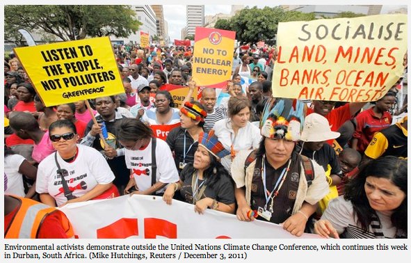
From the Los Angeles Times (Neela Banerjee):

…halfway through a two-week round of climate talks in Durban, South Africa, that excitement has disappeared. Weakened by reversals in Congress and the ailing economy as a presidential election looms, the U.S. delegation has staked out a position that has confused and frustrated environmentalists and other nations.

Doubts have arisen about Washington’s willingness to cut emissions more substantially and its commitment to follow through on helping developing countries already battling climate change, people at the talks said.

The U.S. has shown up “empty-handed, with questions about whether it will be able to meet the emissions-reduction pledge President Obama put forward before Copenhagen,” said Alden Meyer, director of strategy and policy at the Union of Concerned Scientists.

“The question now is whether the U.S. will facilitate progress or block it,” said David Waskow, climate change program director at Oxfam America.

The administration and some allies have pushed back against the mounting criticism, pointing to new rules the U.S. adopted to cut auto emissions and progress at last year’s climate talks in Cancun, Mexico, to aid developing countries.

“The United States is committed to meeting the climate challenge,” said Todd Stern, U.S. special envoy for climate change. “Thanks in significant part to U.S. leadership, the Cancun agreements reached last year included commitments for the first time from all major economies, developed and developing alike, and principles for a system of transparency so that all countries can see whether others are meeting their commitments. There is, of course, much more to be done, but we have made an important start.”[…]

On Wednesday, the chief executives of 16 major environmental groups sent U.S. Secretary of State Hillary Rodham Clinton a blunt letter asking that the United States abandon its negotiating positions. “America risks being viewed not as a global leader on climate change but as a major obstacle to progress,” said the letter, whose signatories include the Sierra Club, Defenders of Wildlife and the Environmental Defense Fund. “U.S. positions on two major issues — the mandate for future negotiations and climate finance — threaten to impede in Durban the global cooperation so desperately needed to address the threat of climate change.”[…]

The U.S. has a history of playing hardball at climate talks. But this time, participants are dismayed that the Obama administration insists on preconditions to negotiations for a legally binding agreement that major emitters such as China and India are unlikely to accept. For instance, Washington seeks unconditional commitments from developing countries to reduce emissions to certain levels, when it remains unclear whether they will get the financial or technological support to do so.

“I think the Americans are nervous that the Republicans are watching what they say and do,” [Alden Meyer, director of strategy and policy at the Union of Concerned Scientists] said from Durban. “They are being very careful so that their position can’t be distorted and used against the president on this issue. That’s perhaps why they’re being more hard line.”

From the Associated Press via The Washington Post:

The top U.N. climate official said Saturday she is confident industrial countries will renew their pledges to cut greenhouse gas emissions after their current commitments expire next year…

“Countries are here these two weeks exactly talking about how they are going to go into a second commitment period of the Kyoto Protocol,” U.N. official Christiana Figueres told The Associated Press.

“The discussion this week is not about the ‘if,’ it’s about the ‘how.’ That doesn’t mean that we are out of the thick of it,” she said. Delegates are discussing participation, the legal form of the rules and all of the conditions that will define the second commitment period, she said.

The Green Climate Fund, designed to help developing nations with clean energy resources, may be a casualty of the 2012 Presidential election. Here’s a report from Kevin Rawlinson writing for The Independent. Here’s an excerpt:

There is still significant disagreement over how to run the Green Climate Fund, intended to channel billions of pounds to help poorer countries take on climate change, with the US and Saudi Arabia said to be standing in the way.

But climate campaigners said yesterday they were hopeful that a deal would be reached without formally reopening debate on the essentials of the Fund, which would delay agreement about how to implement it in practice. Such a hold-up would jeopardize the chances of securing international consensus on what to do when the main provisions of the Kyoto Treaty expire at the end of next year.

“Some of the poorer countries would be unlikely to sign up to any agreement to take over from the Kyoto Treaty without the promise in place to set up some sort of provision to help them grow at the same time as tackling their carbon output, such as the Fund. Because it is so important, people can use it as a football,” said a source at the conference in South Africa.

In a bid to avoid potentially disastrous delays caused by reopening official negotiations on the Fund, the summit’s president – South Africa’s international relations minister Maite Nkoana-Mashabane – is holding a series of informal meetings between the parties. Talks to get to this point have already taken almost a year.

The disagreement surfaced on Wednesday night when delegates from the US and Saudi Arabia said they would not sign off on a report stating how to run the Fund. It is hoped the fund will channel much of the £63bn wealthier countries have pledged to give to their developing neighbours to offset the economic difficulties of limiting their carbon emissions.

They were followed by representatives from Venezuela and other South American nations who expressed doubts about handing a leading role to the World Bank, intended to act as the Fund’s interim trustee, because of its perceived links to the US. Nigerian officials also said they were worried that private sector influence would limit poorer nations’ ability to decide what to spend the money on.

More coverage from BBC News (Richard Black):

The world’s poorest countries have asked that talks on a new climate deal covering all nations begin immediately…

These three developing world giants believe talks on a new mandate should not begin now because developed nations have yet to fulfil existing commitments.

But their smaller peers believe there is no time to lose.

“We put forward our mandate for a new legal agreement today to get things moving quickly in an effort to respond to the urgency of our challenge,” said Selwyn Hart, lead negotiator for Barbados, which chairs the Alliance of Small Island States (Aosis).

“We can no longer afford to wait. We need to conclude the new deal in the next 12 months.”[…]

The 48-country Least Developed Countries bloc (LDCs) includes drought-prone states such as Ethiopia and Mali, those with long flat coastal zones such as Bangladesh and Tanzania, and Himalayan mountain states including Bhutan and Nepal for whom melting glaciers pose serious dangers.

The 39-strong Aosis includes a plethora of Pacific and Caribbean islands, some of which are very low-lying and vulnerable to sea level rise.

The draft mandate that the LDCs launched into the current UN summit in Durban, South Africa, says that talks “shall begin immediately after 1 January 2012 and shall conclude… by COP18 (next year’s summit)”…

Brazil and India have argued that no new process should begin before 2015; and China is also known to be resistant. Along with Canada, the US, Japan and Russia, they have also argued that the current pledges on curbing emissions, which most countries tabled around the time of the Copenhagen summit two years ago and which run until 2020, should not be adjusted before that date.

More coverage from Michael Jakobs writing for The Guardian:

When psychologists identified the phenomenon of cognitive dissonance – the ability to believe two contradictory things at the same time – they might have been describing the world of international climate change negotiations.

Only this month, two authoritative international agencies have pointed out that the world has only a few years left in which to begin taking sufficient action to combat dangerous global warming. The United Nations Environment Programme’s Bridging the Emissions Gap report shows that, even if all countries implement their emissions targets for 2020 to their maximum extent, total emissions in that year will still exceed the level required to hold global warming to the UN’s 2C goal. Further action is needed now, it pointed out, if this emissions gap is to be closed. At the same time, the International Energy Agency warned that the world has only five years seriously to start replacing fossil fuels by low carbon energy and energy efficiency. Failure to make the required investment by 2017 would “lock in” high future emissions to such an extent that the 2C goal would become unattainable.

Yet at the UN climate talks in Durban, delegates are arguing about whether a new round of negotiations should not even begin until 2015, and not come into effect until after 2020. Some countries appear to be throwing the 2C goal away even as they rhetorically reaffirm it.

The positions being taken on this give the lie to the lazy view that climate talks are always a matter of developed versus developing countries. On the one side of this argument are the countries most vulnerable to climate change – the small islands and least developed nations – and the European Union. These want negotiations on a new legal agreement to begin next year, to conclude in 2015, and to enter into force as early as possible thereafter (the EU has said no later than 2020). On the other side, advocating that no new negotiations should start until after 2015 at the earliest, is an unlikely alliance of the usual developed country laggards – the US, Canada, Russia and Japan – and two of the largest emerging economies, China and India.

Here’s a look at Margaret Thatcher former Prime Minister of England and her take on humankind’s influence on the planet, from Michael McCarthy writing for The Independent. From the article:

Nothing wishy-washy, nothing bunny-hugging, nothing lefty about the Iron Lady. And this is what she told the assembled fellows of the Royal Society on 27 September 1988: “For generations, we have assumed that the efforts of mankind would leave the fundamental equilibrium of the world’s systems and atmosphere stable. But it is possible that with all these enormous changes (population, agricultural, use of fossil fuels) concentrated into such a short period of time, we have unwittingly begun a massive experiment with the system of this planet itself.”

Funny old world, innit? These days, if you’re a right-wing Conservative, or a right-wing commentator or blogger, it is virtually a badge of honour to proclaim that all this global warming stuff, and action taken to counter it, is a load of cobblers, nay, more: it is a fraud, perpetrated upon a deceived public by free-spending liberal or left-wing politicians who don’t have Britain’s own best interests at heart, and who are backed up by scientists exaggerating the problem so that they can ensure the continuation of their research funding.

Yet the woman regarded by right-wingers as their icon thought just the opposite. She was at the forefront of those who first perceived, in the late 1980s, that our increasing production of greenhouse gases was posing a real and mortal threat to the stability of the atmosphere and thus to the welfare of human society itself. Her Royal Society speech, passionate in its rhetoric, set off the second wave of environmentalism in this country (after the first one in the late 1960s). In the two years remaining of her premiership, she treated the Tory cabinet to a global-warming seminar, instigated the process of the UK cutting its carbon dioxide emissions and oversaw the establishment of the Hadley Centre at the Met Office, Britain’s world-renowned institute for climate prediction and research.

antarcticmossbed.jpg

From the Summit County Citizens Voice (Bob Berwyn):

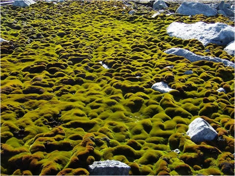
In this era, it’s difficult to find any signs of vegetation in Antarctica, but a few sparse patches of moss suggest that climate change in recent decades is having an impact on the few plants that do grow in the short summer season.

Australian scientists say that, even though we tend to think of Antarctica as the last untouched wilderness preserved from human impact, it is still affected by anthropogenic climate change.
A paper to appear in the January issue of Global Change Biology describes how the growth rate of some of these “old-growth” moss beds has slowed since the 1980s. The results of the study suggest the moss beds are drying out as a result of increased wind speeds around Antarctica that are linked to the Antarctic ozone hole.

Up until now, measuring the seasonal growth rate of these plants has been extremely difficult and hence it was impossible to assess the impact of our changing climate. But the research conducted by team of environmental scientists from the University of Wollongong and nuclear physicists from the Australian Nuclear Science and Technology Organisation used increased concentration of radiocarbon in the atmosphere resulting from nuclear weapons testing (mostly in the late 1950s and early 1960s, called the ‘the bomb spike’) to accurately date the age of the moss shoots along their stems in a similar way to tree-rings.

“This has allowed scientists to show that climate change has made the driest continent on Earth an even harsher environment for plant life,” said Professor Sharon Robinson, of UOW’s Institute for Conservation Biology and Environmental Management.

polarbearsnoaaarcticreportcard2012

Finally, the National Oceanic and Atmospheric Association has released their 2012 Arctic Report Card. Here’s the link to the Marine Ecosystems Summary:

The Marine Ecosystem section of the 2012 Arctic Report Card highlights the highly variable nature of Arctic ecosystems and provides some insight into how the marine ecosystem and the biodiversity it supports are responding to changing environmental conditions. Recent changes in the marine ecosystem, from primary and secondary productivity to responses by some marine mammals species, are summarized in six essays. These essays provide a glimpse of what can only be described as profound, continuing changes in the Arctic marine ecosystem. For example, primary production by phytoplankton in the Arctic Ocean increased ~20% between 1998 and 2009, mainly as a result of increasing open water extent and duration of the open water season (see the essay on Sea Ice). Increases in primary production were geographically heterogeneous, with greatest increases found in the Kara (+70%) and Siberian (+135%) sectors. In addition to shifts in the total amount of production, recent observations indicate an earlier timing of phytoplankton blooms in the Arctic Ocean (advancing up to 50 days over the period 1997-2009), as well as community composition shifts towards a dominance of smaller phytoplankton species. These changes in production were accompanied by biogeochemical shifts in the system, including profound freshening of waters in the Canadian Basin (see the essay on Ocean Temperature and Salinity) and an undersaturation of the surface waters with respect to aragonite, a relatively soluble form of calcium carbonate found in plankton and invertebrates (see the essays on Ocean Biogeophysical Conditions and Ocean Acidification).

Shifts in primary and secondary production have direct impacts on benthic communities. Organic carbon supply to the benthos in regions of the northern Bering Sea has declined ~30-50%, as has the infaunal biomass of bivalves that are winter prey for the World population of the threatened spectacled eider. Recent changes in Arctic benthic biodiversity include shifts in community composition and biomass, which might be related to climate warming. In several cases, switches from longer-lived and slow-growing Arctic species and/or communities to faster-growing temperate species and/or communities reflect increasing water temperatures. Similarly, northern range extensions of several sea floor dwellers likely are tied to the warming habitat. In the Atlantic Arctic, this process is anticipated to result in the ‘Atlantification’ of the benthos, i.e., the replacement of Arctic communities with those endemic to the North Atlantic Ocean. New research on sediment-associated microbes, including bacteria, archaea, viruses and microscopic fungi, are currently expanding our knowledge of this topic.

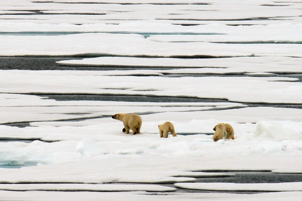
Changes in the Marine Ecosystem are affecting higher-trophic species including seabirds and marine mammals. For example, 7 of 19 of the world’s polar bear sub-populations are declining in number, with trends in two populations linked to reductions in sea ice. Thousands of walruses had hauled out on the NW coast of Alaska by mid-August 2011, the fourth time in the past five years for a behavior thought to be triggered by a lack of sea ice in the Chukchi Sea (see the essay on Sea Ice). These unprecedented haul-outs result in pup mortality by crushing and a switch in foraging by walrus from moving sea ice to static shore sites. Conversely, the decline in sea ice extends access to waters north of Bering Strait for feeding by seasonally-migrant baleen whales. Sea ice reductions in the Northwest Passage also provided the opportunity for overlap between bowhead whales from the West Greenland and the Alaska populations, suggesting that reduced summer sea ice may facilitate exchange between the two populations.

Here’s the Terrestrial Systems Summary:

The Terrestrial Ecosystem section of the 2012 Arctic Report Card illustrates the interconnections between the Arctic marine and terrestrial ecosystems. An example is the direct link between increases in Arctic tundra vegetation productivity and earlier peak productivity in many parts of the Arctic on one hand and increasing duration of the open water season and decreasing summer sea ice extent on the other (see the essay on Sea Ice).

The Normalized Difference Vegetation Index (NDVI) shows that there is a long-term trend of increased biomass production in many parts of the Arctic. Over the whole Arctic from 1982 to 2010, the maximum summer NDVI increased by an average of 8%. However, there is considerable spatial variability, ranging from a 26% increase in lands adjacent to the Beaufort Sea to a small decline in several areas. The areas of greatest increase appear to be correlated with adjacent coastal areas that have experienced dramatic retreats in summer sea ice extent (see the essay on Sea Ice). Despite these long-term trends, annual variation is significant. In 2009, circumpolar NDVI showed a dip that corresponded to elevated atmospheric aerosols and generally cooler summer temperatures over the Arctic. Then, in 2010, NDVI rebounded strongly in North America, but less so in Eurasia. Information from long-term ground-based observations shows that, in addition to increasing air temperatures and loss of summer sea ice, widespread greening is also occurring in response to other factors. These include landslides and other erosion features related to warming permafrost, tundra fires and factors related to increased human presence in the Arctic.

The impacts of increased biomass production in Arctic tundra ecosystems on arctic wildlife are unclear. Despite changes in tundra biomass, migratory barren-ground caribou appear to be within known ranges of natural variation, with many herds that have experienced declines in the past decade beginning to increase or stabilize. Despite this, rapid environmental and social changes in the Arctic are a concern.

Here’s the Hydrology and Terrestrial Cryosphere Summary:

The Hydrology & Terrestrial Cryosphere section of the 2012 Arctic Report Card documents consistent and widespread evidence for continuing change in snow cover, glaciers and ice caps, the Greenland ice sheet, permafrost, lake ice, river discharge and river biogeochemistry. On the Greenland ice sheet and on most glaciers and ice caps elsewhere in the Arctic, the period 2010-2011 was characterized by a negative mass balance, i.e., more snow and ice was lost, primarily by surface melting and runoff, than snow was gained. The western slope of the Greenland ice sheet in particular experienced a significant increase in surface melting, amplified by albedo feedback and, in 2011 and 2010, by below-normal summer snowfall. GRACE satellite gravity solutions show that the mass loss from the entire ice sheet during the 2010-2011 balance year was -430 Gt, the largest annual loss in the GRACE record (2002-present) and equivalent to a eustatic sea level rise of 1.1 mm. Mass losses in summer 2011 are linked to positive surface and upper air temperature anomalies similar to those observed in 2007 and 2005.

Below-average snow extent during spring 2011 is consistent with a decline observed since the 1970s, and continues an accelerated decrease since 2006. June snow cover extent in Eurasia was the lowest since the start of the satellite record in 1966. Positive snow water equivalent (SWE) anomalies in the North American Arctic in 2011 were the third highest since the start of the time series in 1980. Despite this, spring snow cover extent and duration were below-average across both the North American and Eurasian sectors of the Arctic due to positive air temperature anomalies in May and June, the two primary months for snow melt. A general increase in permafrost temperatures observed in Alaska, northwest Canada, Nordic countries, and in Siberia during the last several decades continued in 2010-2011. New record high permafrost temperatures at 20 m depth were measured in 2011 at all observatories on the North Slope of Alaska, where measurements began in the late 1970s. However, a slight decrease (by as much as 0.3°C) in Interior Alaska has been observed during the last three years.

Lake ice cover duration, largely influenced by air temperature changes, was shorter by as much as 4-5 weeks in 2010-2011 compared to the 1997-2010 average for the eastern Canadian Arctic. River discharge into the Arctic Ocean during 2010 was close to the long-term (1936-2009) mean for the six largest Eurasian Arctic rivers and the four large North American Arctic rivers. Preliminary estimates for 2011, based on modeling and some observations, indicate river flows to the Arctic Ocean during January to July were significantly lower than the long-term mean. In 2010, dissolved organic carbon (DOC) flux from five of the six largest Arctic rivers was less than the 2003-2009 average. Combined DOC flux from all six rivers peaked in 2007, but has been lower each year since, closely tracking the downward trend in their combined discharge.

More coverage from the Environmental News Service. From the article:

The Arctic is entering a new state with warmer air and water temperatures, less summer sea ice and snow cover, and changed ocean chemistry, finds the annual Arctic Report Card. Less habitat for polar bears and walruses but increased access to feeding areas for whales characterizes the new Arctic pattern.
The 2012 Arctic Report Card was prepared by an international team of scientists from 14 different countries and issued today by the National Oceanic and Atmospheric Administration, NOAA.

“This report, by a team of 121 scientists from around the globe, concludes that the Arctic region continues to warm, with less sea ice and greater green vegetation,” said Monica Medina, NOAA principal deputy under secretary of commerce for oceans and atmosphere.

Scientist records conditions in the Chukchi Sea (Photo courtesy Karen Frey/NOAA)

“With a greener and warmer Arctic, more development is likely,” Medina said. “Reports like this one help us to prepare for increasing demands on Arctic resources so that better decisions can be made about how to manage and protect these more valuable and increasingly available resources.”

The Report Card tracks the Arctic atmosphere, sea ice, biology, ocean, land, and Greenland. This year, new sections were added, including greenhouse gases, ozone and ultraviolet radiation, ocean acidification, Arctic Ocean primary productivity, and lake ice.

In 2011, the near-surface air temperatures over much of the ocean were approximately +1.5 degrees Celsius greater than the 1981-2010 baseline period. Land temperatures also topped their baseline values. This continued a decade-long warming of the Arctic relative to mid-latitudes, the scientists report.

“This pattern is responsible for sending cold air from the Arctic southward into eastern North America and northern Europe, and warm air from the sub-Arctic northward into western Greenland and east Asia,” says James Overland of NOAA’s Pacific Marine Environmental Laboratory in Seattle, who coordinated the atmosphere section of the report card.

More coverage from the Associated Press via CBSNews.com:

The Arctic acts as Earth’s refrigerator, cooling the planet. What’s happening, scientists said, is like someone pushing the fridge’s thermostat much too high. “It’s not cooling as well as it used to,” Richter-Menge said.

The dramatic changes are from both man-made global warming and recent localized weather shifts, which were on top of the longer term warming trend, scientists said. The report, written by 121 scientists from around the world, said statistics point to a shift in the Arctic health in 2006. That was right before 2007, when a mix of weather conditions and changing climate led to a record loss of sea ice, from which the region has never recovered. This summer’s sea ice melt was the second worst on record, a tad behind 2007. “We’ve got a new normal,” said co-author Don Perovich, a geophysicist at the Army Corps of Engineers Cold Research and Engineering Lab. “Whether it’s a tipping point and we’ll never recover, who’s to say?”

The report highlighted statistics to show an Arctic undergoing change:

-A NASA satellite found that 430 billion metric tons of ice melted in Greenland from 2010 to 2011, and the melting is accelerating. Since 2000, Greenland’s 39 widest glaciers shrunk by nearly 530 square miles (1,375 sq. kilometers), about the equivalent of 22 Manhattans.

-The past five years have had the five lowest summer sea ice levels on record. For two straight years, all three major passages through the Arctic have been open in the summer, which is unusual.

-Seven of 19 polar bear sub-populations are shrinking.

-This year’s temperature is roughly 2.5 degrees Fahrenheit (1.4 C) higher than what had been normal since 1980.

Drew Beckwith (Western Resource Advocates): ‘The CWCB has done a tremendous service to Colorado citizens by approving these guidelines,’ for municipal conservation reporting

xeriscapelandscape.jpg

Here’s the release from Western Resource Advocates (Jason Bane):

The State of Colorado has adopted a plan to create the most comprehensive water reporting guidelines in the country, positioning the state as a national leader in water conservation and supply planning.

On Wednesday, Nov. 16, the Colorado Water Conservation Board (CWCB) formally adopted new water use and conservation reporting rules, called Guidelines Regarding the Reporting of Water Use and Conservation Data by Covered Entities1. The CWCB will now develop an online reporting tool for water providers that will, for the first time, enable an aggregate picture of water use and conservation in Colorado.

“Colorado has a good record of tracking how much water comes out of rivers and watersheds, but it’s not easy to find out what happens next,” said Drew Beckwith, Water Policy Manager at Western Resource Advocates. “Providers could be doing a great job on conservation, or they could be using most of their supply for water balloons and squirt guns—that’s why comprehensive reporting is so important. The CWCB has done a tremendous service to Colorado citizens by approving these guidelines.”

Western Resource Advocates (WRA) and the Colorado Environmental Coalition (CEC) have been instrumental in creating these new reporting policies. In 2009 the groups jointly drafted legislation to establish new water reporting guidelines that led to the final version of HB10-10512; the bill was approved by the Colorado General Assembly in 2010, and then-Gov. Bill Ritter signed it into law on June 7, 2010. The Office of Water Conservation and Drought Planning convened 13 meetings beginning in Nov. 2010 to draft the proposed guidelines, and WRA and CEC remained involved in the process throughout.

“When the reporting process begins in 2013, Colorado will have the most comprehensive set of water data in the country,” said Beckwith. “You can only manage what you measure. This information will be incredibly helpful for statewide water supply planning and for the water suppliers themselves.”

The newly-approved water reporting guidelines include several categories:
• Water Usage: Amount of water that gets used by different customer classes (residential, commercial, etc.)
• Water Loss: Tracking water that is treated but not used for revenue-generating purposes. Includes leaks, meter inaccuracies, and other non-metered uses (such as firefighting).
• Rate Structures: Reporting rate structure types and the variable costs charged to customers.
• Water Conservation Programs: Outlines individual water conservation programs selected by each
provider.

More coverage from Chris Woodka writing for The Pueblo Chieftain. From the article:

The Colorado Water Conservation Board adopted new reporting rules at its November meeting amd over time will provide a way to measure water conservation statewide…

“Providers could be doing a great job on conservation, or they could be using most of their supply for water balloons and squirt guns — that’s why comprehensive reporting is so important. The CWCB has done a tremendous service to Colorado citizens by approving these guidelines.”

More conservation coverage here. More CWCB coverage here. More HB 10-1051 coverage here.

The Arkansas River Compact Commission will meet Thursday in Lamar

arkansasriverbasinwikipedia.jpg

From The Pueblo Chieftain (Chris Woodka):

The Arkansas River Compact Administration will meet at 8:30 Thursday morning in Lamar, and two proposed projects for the The engineering committee has scheduled discussions on Wednesday about the Arkansas Valley Super Ditch and a proposed pipeline by GP Water from Lamar to Elbert and El Paso counties. The administration could take up discussion of either item if it is referred from the committee…

The purpose of the compact is to settle disputes over use of the Arkansas River and to remove causes of future controversy between Colorado and Kansas. The administration for years was deadlocked as the 1985 U.S. Supreme Court case over the compact unfolded. The case was finally settled in 2009 with a final opinion.

Colorado representatives are Jennifer Gimbel, executive director of the Colorado Department of Natural Resources; Colin Thompson of Holly; and Matt Heimerich of Ordway.

Kansas representatives are David Barfield, chief engineer of the Kansas Department of Agriculture’s Division of Water Resources; David Brenn of Garden City; and Randy Hayzlett of Laki.

More Arkansas River basin coverage here.

Snowpack news: The Roaring Fork River watershed above Aspen is off to a better start than last season

snowpackcolorado12022011

From The Aspen Times (Janet Urqurhart):

The dearth of snow in town in November was not, however, reflected on the ski slopes. The upper slopes of Snowmass collected 41 inches of snow in November — more than the 36 inches that fell at the ski area during the same month a year ago. Still, most of this year’s snow came early in the month, with two storms during the first week of November. The water plant recorded 8 inches of new snow on the morning of Nov. 2 and measured another 6 inches on Nov. 6. Other forecast storms were a bust, but the plant recorded 2.1 inches of snow on Nov. 14 and lesser amounts on other days.

Drought news: Some precipitation has helped Southern Colorado but it is still very dry

usdroughtmonitor11292011

From The Pueblo Chieftain (Chris Woodka):

The latest forecast from the state’s Water Availability Task Force, a consortium of agencies coordinated through the state Department of Natural Resources, predicts a drier, hotter autumn for the region. The task force met last week. “The long-term seasonal climate forecast indicates that the return of La Nina conditions will likely result in drier conditions than last year,” said Veva DeHeza of the Colorado Water Conservation Board. “Below average conditions in the southeastern portion of the state are likely to persist with a chance of normal precipitation in the mountains for the midwinter.”

Here’s the executive summary from the most recent Water Availability Task Force meeting (Veva Deheza/Kevin Rein):

Exceptional and extreme drought conditions continue to impact Baca County in southeast Colorado. However, drought conditions in other areas of the state have seen significant improvement over the last two months. Moderate to severe conditions remain throughout the southeastern and south central portions of the state, including the San Luis Valley.

Reservoir storage remains above average in the Yampa/White, Gunnison, Colorado, South Platte Basins, and San Miguel/ Dolores/ Animas/ San Juan. Statewide, reservoir storage is 103% of average. The Rio Grande and the Arkansas River basins continue to be the regions with the lowest reservoir storage levels in the state at 60 and 88% of average, respectively. Municipalities present at the November WATF meeting feel that they have adequate storage and have transitioned to winter operations.

– As of November 22, 34% of the state is now experiencing some level of drought conditions, according to the U.S. Drought Monitor, a decrease from previous months. D3 and D4 conditions remain only in Baca County, while D2 and D1 conditions are impacting much of the rest of the southeastern parts of the state. D0-D4 represents abnormally dry, moderate, severe, extreme and exceptional drought conditions, respectively.

– Surface Water Supply Index (SWSI) values range from 0 in the San Miguel/ Dolores/ Animas/ San Juan to +3.5 in the Yampa/ White basin. According to the revised SWSI, the Dolores and Animas in the southwest were drier than the other southwestern basins at -2.61and -2.03 respectively. The San Miguel and San Juan both experienced near normal conditions.

– At the Walsh weather station, in southeastern Colorado, a new record low for precipitation was recorded for the month of August and September ending the water year far below normal at just 35%. While they did not set new records, Pueblo, Alamosa, and Del Norte also finished the water year well below normal at 60, 61 and 49% respectively.

– The long term seasonal climate forecast indicates that the return of La Nina conditions will likely result in drier conditions than last year which was extremely wet in our north-central mountains. Nevertheless, the current precipitation outlook for early next year is near-normal in most of the state, with a chance of even above-normal precipitation in the north-central mountains.

– It is too early to tell what the implications of the seasonal drought of 2011 may have on fish and wildlife populations in the southern portion of the state, and the habitats upon which they depend. So far, there have been no reports of significant or widespread adverse impacts that can be directly attributed to the drought. Task force members are keeping a watchful eye on the availability of food supplies and water needed to sustain major life cycle events of existing populations and species.

– The Agricultural Impact Task Force (AITF) has recommended to the Drought Task Force that regular meeting be suspended until the early part of 2012 when more information on winter precipitation will be available. However the AITF remains activated should conditions in the southeastern portions of the state require immediate response.

Colorado Springs: The city council approves a six month moratorium on oil and gas operations within the city limits

derrick.jpg

From the Denver Business Journal (Cathy Proctor):

Colorado Springs’ city council on Wednesday voted 8-0 to impose an “emergency ordinance” creating a six-month moratorium on applications for oil and gas operations within city limits, a move that could delay Houston’s Ultra Petroleum Corp. to drill on its land in the city…

Council President Scott Hente told the Colorado Springs Gazette newspaper that the proposed moratorium would give the city “some breathing room” to ensure it has the right regulations and ordinances in place.

More coverage from The Colorado Springs Gazette (Debbie Kelley):

While Colorado Springs City Council on Wednesday enacted a six-month moratorium on oil and gas exploration within city limits, Ultra Resources has submitted temporary use permit applications with El Paso County. Ultra is seeking county approval for three well sites in eastern El Paso County. The company also is getting state approval for the drilling. The applications are being worked through the county’s permitting system, said Craig Dossey, a county project manager and planner.

More coverage from The Colorado Springs Gazette (Daniel Chacón). From the article:

The six-month moratorium comes after a Texas-based energy company said in June that it wanted to drill for oil and gas on the sprawling Banning Lewis Ranch on the east side of the city. “I think it’s absolutely irresponsible for us not to look at our future and identify what the potential is for damage to us — or the good things that could come out of this if it’s done right,” City Councilman Merv Bennett said.

Issues the city might consider include water quality, soil erosion, wastewater disposal, wildlife and vegetation, geologic hazard and road degradation, City Attorney Chris Melcher said during the council’s special meeting…

The council’s moratorium, approved on an 8-0 vote, was created under an “emergency ordinance” that required only one reading. Nearly every ordinance that goes before council requires two readings…

About six people spoke in favor of the moratorium. Only one person, a representative from the Colorado Oil and Gas Association who drove to the Springs from Denver, spoke in opposition. Andrew Casper, the association’s regulatory counsel, said the oil and gas industry already faces extensive regulations at the state level. He encouraged the city to work within the state process and not to “rush” by enacting a moratorium.

More coverage from the Colorado Springs Independent (Pam Zubeck):

About a half-dozen residents voiced support for the hiatus, including Mary Talbott. “Six months will not make a huge difference in the oil and gas industry,” Talbott said. “The fact that you take the time to develop a coherent set of rules that protect our … environment and long-term prosperity is very important.”

Other residents expressed concerns about groundwater contamination, air pollution and a heavy industrial activity that could discourage the area’s prime economic driver — tourism.

The vote was 8-0 in favor of the moratorium, with Councilman Bernie Herpin absent

More oil and gas coverage here and here.

The City of Delta is moving to the next phase to establish a stormwater utility

lightning.jpg

From the Delta County Independent:

The City of Delta has embarked on the next step in the process to create a stormwater utility program. The results of a needs analysis study, identified as Phase 1 in the process, were presented to the city council earlier this month.

By a unanimous vote, they agreed to proceed with Phase 2, program development, and Phase 3, establishing rates and implementing a billing system which will be applied to every home and business in the city.

The City of Delta has been working with URS to develop a long-term strategic plan for addressing the city’s stormwater needs.

Although there is some infrastructure in place, the downtown stormwater collection system is “significantly undersized and lacks the capability to convey the 100-year storm event.” As a result, low-lying areas with no outlet tend to flood after heavy rains.

More stormwater coverage here.

Centennial: State Representative Spencer Swalm’s next town hall meeting, December 17, will focus on hydraulic fracturing

marcellushydraulicfracturing.jpg

From the Centennial Citizen:

The meeting is scheduled for 9 to 11:30 a.m. Dec. 17 at the Koelbel Library, Room B, 5955 S. Holly St., Centennial.

More oil and gas coverage here and here.

Audubon International recognizes the Boulder Flatirons Golf Course as a certified cooperative sanctuary

baldeagle.jpg

Update: Here’s a correction sent in by Joellen Lampman with Audubon International:

The post states that the National Audubon Society recognized the course. In fact, the course was recognized by Audubon International through the Audubon Cooperative Sanctuary Program for Golf Courses. Audubon International has no relationship with the National Audubon Society.

Here’s the release from Boulder Parks and Recreation:

The Parks and Recreation Department’s Flatirons Golf Course has acheived a one-year milestone as a “Certified Audubon Cooperative Sanctuary” through the International Audubon Cooperative Sanctuary Program for Golf Courses. Flatirons was the 35th golf course in Colorado to achieve full Audubon certification. Doug Cook, PGA Director of Golf, led the effort to obtain sanctuary status. The course was recognized for Environmental Stewardship by Audubon International.

“After a year in the program, I can honestly say that the golf experience has been enhanced by our participation in the Audubon International Sanctuary golf course program,” Cook said. “We are very happy with all of the results of this program.”

To be certified, a course must demonstrate it is maintaining a high degree of environmental quality in a number of areas: environmental planning, wildlife and habitat management, outreach and education, chemical use reduction and safety, water conservation, and water quality management.

The most recent program improvements to Flatirons Golf Course have included improving and installing 12 bird boxes and six bat boxes, and completing an irrigation upgrade that is saving water and electricity at a rate of up to 15 percent.

“The Audubon certification is another way we are achieving our department goal of environmental leadership as well as meeting the City of Boulder’s environmental and sustainability goals,” said Kirk Kincannon, director of the City of Boulder’s Parks and Recreation Department. “We are proud of the environmental achievements at Flatirons Golf Course.”

The Audubon Cooperative Sanctuary Program for Golf Courses, endorsed by the United States Golf Association, provides information and guidance to help golf courses preserve and enhance wildlife habitat, and protect natural resources. Golf courses from the United States, Africa, Australia, Canada, Central America, Europe and Southeast Asia also participate in this environmental certification program.

More conservation coverage here.

Colorado River District Launches 2012 Water Resources Grant Program

coloradoriverbasincgs.jpg

Here’s the release from the Colorado River District:

As of December 1st, the Colorado River District is accepting grant applications for projects that protect, enhance or develop water resources within its 15-county region. The Colorado River District includes all watersheds of the Colorado River within western Colorado, except those that drain to the San Juan River.

Projects eligible for the grant program must achieve one or more of the following objectives:

♦ develop a new water supply
♦ improve an existing system
♦ improve instream water quality
♦ increase water use efficiency
♦ reduce sediment loading
♦ implement a watershed management action
♦ control tamarisk
♦ protect pre-1922 Colorado River Compact water rights

Previously funded grants included financial assistance for the construction of new water storage, the enlargement of existing water storage or diversion facilities, rehabilitation of non- functioning or restricted water storage / delivery / diversion structures, implementation of water efficiency improvements and watershed enhancements. Such projects that utilize water rights that are senior to 1922 will be given additional ranking priority over similar projects that do not. Each project will be ranked based upon its own merits in accordance with published ranking criteria.

Successful grantees can receive up to a maximum of $150,000 (or approximately 25% of the total project cost whichever is less; in the case of smaller projects, this percentage may be slightly higher) for their project. The total amount available for the 2012 competitive grant program is $250,000. The application deadline is Jan. 31, 2012.

To access the Water Resources Grant Program application, guidelines and policies, please visit www.ColoradoRiverDistrict.org/page_193. For additional information please contact Alesha Frederick at 970-945-8522; Colorado River District, 201 Centennial St., Glenwood Springs, CO 80601 or e-mail grantinfo@crwcd.org.

More Colorado River basin coverage here.

Hacking of Illinois SCADA installation, ‘cannot be substantiated,’ according to an announcement released Tuesday by the Department of Homeland Security

cyberattackmaximumpc.jpg

From Wired (Kim Zetter):

A report from an Illinois intelligence fusion center saying that a water utility was hacked cannot be substantiated, according to an announcement released Tuesday by the Department of Homeland Security.

Additionally, the department disputes assertions in the fusion center report that an infrastructure-control software vendor was hacked prior to the water utility intrusion in order to obtain user names and passwords to break into the utility company and destroy a water pump.

The DHS notice, released late Tuesday, asserts that information released by the Illinois Statewide Terrorism and Intelligence Center earlier this month about the water pump was based on raw and unconfirmed data, implying that it should never have been made public.

Comment Period Extended for Scoping and EIS on Glen Canyon Dam Operations

glencanyondam.jpg

Here’s the release from the U.S. Bureau of Reclamation (Barri Wirth/Maureen Oltrogge):

The public’s opportunity to provide input to the preparation of a new Environmental Impact Statement related to the operation of Glen Canyon Dam on the Colorado River has been extended to January 31, 2012. The EIS concerns the adoption of a Long-Term Experimental and Management Plan for the Operation of Glen Canyon Dam and is being jointly developed by the Bureau of Reclamation and the National Park Service, both units of the Department of the Interior.

To date, six open-house scoping meetings have been held in Arizona, Colorado, Nevada and Utah. Additionally, a national session was held via the internet. The previous comment deadline was December 30, 2011. A number of interested parties requested the extension to enable the public to provide more thorough comments plus accommodate the end-of-year holiday season.

The long-term plan will address routine operations as well as “experimental” flows that provide additional scientific information about how to protect endangered fish and lessen the effects of dam operations on the downstream ecology and other resources. The plan will ensure that regulated flows on the Colorado River meet the goals of supplying hydroelectricity and water for communities, agriculture and industry at the same time they protect the ecologies of the Grand Canyon and Glen Canyon. Work on the new plan, known as the Long-Term Experimental and Management Plan, is the first comprehensive review of Glen Canyon Dam operations in 15 years. The purpose of the LTEMP is to use current and newly developed science to improve and protect resources of Glen Canyon National Recreation Area and Grand Canyon National Park while also complying with the Law of the River, the 1992 Grand Canyon Protection Act, the Endangered Species Act, and other applicable laws. The LTEMP process will determine the need for future modifications to Glen Canyon Dam operations, and whether to establish an Endangered Species Act Recovery Implementation Program for endangered fish species below Glen Canyon Dam.

Changes to dam operations and other actions taken by the Department of the Interior will be evaluated as “alternatives” in an Environmental Impact Statement. The EIS will document and evaluate impacts of the alternatives.

More information on the EIS process may be found on the project web site: http://ltempeis.anl.gov. The public can submit comments by the following methods:

– Website: http://ltempeis.anl.gov. (the preferred method)
– Mail: Glen Canyon LTEMP EIS Scoping, Argonne National Laboratory, EVS/240, 9700 S. Cass Avenue, Argonne, IL 60439

Reclamation and the NPS will accept comments that are received or postmarked by Friday, January 31, 2012.

More Colorado River basin coverage here.

Sand Creek: Suncor crews are constructing a trench to intercept the benzene laden flows

sandcreekepasamplinglocations12022011

Here’s a report from Bruce Finley writing for The Denver Post. He, and the Post in general, have done a very comprehensive job of covering the spill so far. Click through for the whole article and video of the cleanup. Here’s an excerpt:

The latest data show the concentration of cancer-causing benzene at levels 69 times higher than the national drinking-water standards at the point where Sand Creek enters the South Platte River.

Once the trench is completed, U.S. Environmental Protection Agency emergency-response coordinators said, the EPA will scale back the federal role and rely on Colorado health officials to oversee a long-term cleanup…

About 100 feet of the trench is complete. Suncor refining vice president John Gallagher said he expects the work to be completed next week.

Kimbel said state health and Suncor officials now “have got to figure out what the source is, how it is getting there and what they have to do to address it.”[…]

EPA contractors have begun testing for benzene, ethylbenzene, toluene and xylene and on Friday released results from Tuesday and Wednesday. Tests of samples drawn from Sand Creek on Wednesday show benzene concentrations of 1,970 parts per billion at the point where the liquid enters the creek, and 348 ppb at the point where the creek flows into the South Platte. Tests at a location across the main channel of the South Platte showed a concentration of 108 ppb.

More coverage from Bruce Finley writing for The Denver Post. From the article:

No public health warnings have been issued. Kimbel said today that people who stay on the bike path along the Sand Creek Regional Greenway should be safe. A well-delineated “hot zone” has been set up around the area where clean-up crews are working to stop the flow of contaminants into the creek.

Battling snow, freezing temperatures and mud, they have been pushing to catch and contain the liquid as it seeps from the shoreline, preventing further contamination of the creek and South Platte River. Workers also have used heavy machinery to buttress absorbent booms strung across the creek. Suncor is taking “all the action that we believe is necessary,” said John Gallagher, company vice president for refining.

But there’s no easy end in sight to the situation in this industrial zone — a situation that over the past year took a turn for the worse with new hydrocarbon and dissolved petroleum compounds moving in groundwater and surfacing as vapors in nearby Metro Wastewater buildings…

Even before Suncor bought the refinery from Conoco in 2003, pollution now migrating to the wastewater plant — where one building is partly closed and workers have been forced to wear respirators — was documented. Oil refineries have existed at the Suncor property under various owners since the 1930s. About 300 groundwater wells have been drilled around the property and at the wastewater plant to track contamination — 25 of them capable of recovering liquids. Much of what regulators have been monitoring is described as “legacy contamination,” consisting of “mostly tarry asphaltic pockets of petroleum products underground that have not been moving,” said Warren Smith, a state health department spokesman.

More Sand Creek spill coverage here. More oil and gas coverage here and here.

Leadville: Public celebration for the delisting of Operable Unit 9 from the California Gulch Superfund Site, December 9

californiagulchleadville.jpg

From the Leadville Herald-Democrat:

Residents of Leadville and Lake County are invited to celebrate the fact that, after almost 30 years, most are no longer living in a Superfund site. Specifically the celebration is for the deletion of Operable Unit 9 from the California Gulch Superfund Site; OU9 encompasses the downtown area and West Park. The event will be Friday, Dec. 9, from noon to 2 p.m. at the National Mining Hall of Fame and Museum, 120 W. 9th St. It is being held by the city of Leadville, Lake County, the Colorado Department of Public Health and Environment and the Environmental Protection Agency. Information will be presented on the history of the Superfund site, the OU9 remedy, and current and future cleanup progress. Light refreshments will be served.

More California Gulch coverage here and here.

Pagosa Springs hopes to expand use of geothermal resources in 2012

pagosahotsprings.jpg

From the Pagosa Sun (Jim McQuiggin):

On Monday, Pagosa Springs Mayor Ross Aragon invited SUN staff into his office to discuss several projects that suggest the town could be on the threshold of significantly expanding the use of its geothermal resources, potentially putting Pagosa Springs on the map as a leader in green energy production and self-sustainability…

Long a pet project of the mayor’s, a geothermal greenhouse may soon be a feature in the core downtown area. With preliminary engineering completed on the project, Aragon indicated that the first of three greenhouses could be installed as soon as early summer…

To be located at the west end of Centennial Park, the project will ultimately include three, 51-foot growing domes, each with a specific purpose. The first to be installed will be used for education, with local K-12 students, as well as college students, studying permaculture practices and geothermal potential. Through their work and research, those students will determine which crops do well in geothermally-heated greenhouses, with the results of that research determining what would be grown in the second dome, used for commercial production…

One project, approved earlier this year by the Pagosa Springs Town Council and the Archuleta County Board of County Commissioners, is a study that monitors the town’s geothermal wells in order to gather real-time data, measuring the extent of the geothermal aquifer’s behavior as well as the extent of available resources. To be conducted by Gerry Huttrer, president of the Geothermal Management Company (GMC) and one of the geothermal energy experts who has visited Pagosa Springs on numerous occasions to scope out area geothermal resources, the project would test the hypothesis that (as Huttrer and other geothermal experts proposed in a study released last October) “ … appears as if the geothermal resource is currently underutilized.”[…]

With meters installed on many geothermal wells throughout the area, data collected will measure moment-to-moment flows and temperatures. In a second phase of the study, Pagosa Springs Well No. 3 will be opened up (several times) to test the effects of uninhibited flows on the aquifer’s pressure and temperatures. That second phase has been timed to coincide with low use of geothermal wells to minimize potential effects on well users. A third phase would drill to various depths and then reinject the pumped water back into the aquifer in order to test the effect of cooled water on the reservoir…

Another project (as reported in the Nov. 3 edition of The SUN) will be conducted next May, complementing Huttrer’s research. At that time, Dr. Terry Young (head of the Geophysics Department at the Colorado School of Mines), Dr. Michael Batzle and Dr. André Revil (both professors of geophysics at Mines) will converge on Pagosa Country with dozens of graduate students, researching numerous characteristics of the aquifer…

Finally, Smith described what he calls “The Power Project” — research that would test temperatures and pressures deeper within the aquifer in order to see if conditions are sufficient for power generation. The first phase of the project entails shallow drilling into the aquifer to gather gases generated in the geothermal reservoir. Those samples will be sent to the University of New Mexico to determine what kinds of isotopes are generated in the aquifer. If those isotopes are specific to pressures and temperatures that suggest the potential for power generation, a second phase would drill deeper into the aquifer to determine if phase one results were accurate. Current understanding of the aquifer shows temperatures somewhat below the threshold required for power generation. If research shows that temperatures deep within the aquifer exceed those needed to generate power, “The Power Project” would proceed with the installation of Colorado’s first geothermal power plant.

More geothermal coverage here and here.

Mt. Princeton Geothermal public meeting recap: Magnetotelluric survey, to be completed by the end of the month, does not involve drilling

magnetotelluricsurveynewmexico.jpg

From The Mountain Mail (Joe Stone):

Fred Henderson and Hank Held of Mt. Princeton Geothermal, LLC, organized the meeting, and Warren Dewhurst provided information about the magnetotelluric survey his company, Dewhurst Group, LLC, will conduct. Held, founder of Mt. Princeton Geothermal, acknowledged the controversial nature of efforts to develop the geothermal resource. He said, “There will continue to be controversy until questions are answered.”

Those questions will not be answered without drilling a deep test well, and Henderson, chief scientist with Mt. Princeton Geothermal, said an investor is interested in drilling a deep well in the area. He said the investor requested the magnetotelluric survey, which, along with shallow temperature measurements, will identify the best place to drill a deep well.

Dewhurst said the survey will be completed before the end of the month, will not involve any drilling and will require at least 100 sites for good results…

Dewhurst said the survey will involve technicians placing five electrodes and two magnetometers on the ground at each site and taking readings for two hours before moving to the next site…

Dewhurst said his company’s technology is capable of modeling subsurface electrical conductivity to 10 kilometers (6 miles) or deeper. It works well for geothermal exploration because geothermal water is an electrical conductor…

More information about the magnetotelluric technology used by Dewhurst Group is at www.dewhurstgroup.us.

More geothermal coverage here and here.

Aspen: Geothermal test well has yet to hit water

geothermalenergy.jpg

From the Aspen Daily News (Andrew Travers):

As of Thursday afternoon, they had drilled down 1,003 feet. They had expected to reach water, for temperature-taking, by 1,000 feet underground. The city’s drilling permit allows them to drill as far as 1,500 feet…

She said the city does not have a precise finish date at this time, but the driller — California-based Dan’s Water Well & Pump Service — believes it’s on the verge of hitting water. “Our experts believe it’s close but it’s impossible to pinpoint the exact depth until we reach it,” [Lauren McDonell, the city of Aspen’s environmental programs manager] said…

The work has…been slowed, at points, by the density of the Leadville limestone through which the crew is drilling. A partial collapse of the 6-inch-diameter hole Wednesday also delayed their progress. The drillers were installing steel casing Wednesday to reinforce the hole, before they begin to drill deeper…

Anecdotal reports from 19th century miners about the extreme heat in mines below town have indicated that geothermal could be harnessed for 21st century needs. A 2008 geothermal feasibility study boosted hopes further, indicating that the temperature of local underground water ranges from 90 to 140 degrees. To heat or cool buildings with geothermal energy, 100-degree water is required.

More geothermal coverage here and here.

Reclamation and the Tri-County Water Conservancy District deal would lead to a 7 megawatt hydroelectric generation plant at the Ridgway Dam

ridgwaydamusbr.jpg

From The Telluride Daily Planet (Benjamin Preston):

In September, the U.S. Bureau of Reclamation, which owns the dam, submitted a draft environmental assessment examining a lease agreement with the Tri-County Water Conservancy District, the agency that would build the plant and sell electricity to the grid. Public comment on the environmental assessment recently ended, and a spokesperson from the Bureau said that public input generally favored the project.

Tri-County manages Ridgway Dam, providing 28,100 acre-feet of water to 7,500 domestic water taps and 11,200 acre-feet to more than 50,000 acres of agricultural land. (An acre-foot is the amount of water it takes to cover an acre of land with a foot of water, or about 326,000 gallons.) Tri-County District Manager Mike Berry said that aside from storing municipal and irrigation water, the dam was originally intended to include a hydroelectric plant. Although the Bureau of Reclamation owns the dam, it can allow a non-federal agency to develop hydropower with a lease of power agreement. “The dam has been there a long time, so it’s time to use the power that comes from the release of water,” Berry said. “It’s clean, green energy and everyone likes it.”

Berry added that the district is in the process of seeking buyers for the electricity, and hopes to get a purchase of power agreement signed within the next 90 days. Without contracts in place, the project will not proceed, but the City of Aspen and a few other entities have expressed interest in buying power from the district…

Conceptual plans for the new plant call for two turbines, one rated at 4.9 megawatts and the other at 2.1. Berry said half the electricity produced by the plant would be cranked out between June and September, with the rest trickling in during the other eight months of the year.

Berry said that based upon federal biological studies, the way the turbines and their attendant pipework are designed could improve water quality. The turbines, planned to be independent of the dam’s current spillway, will discharge water through submerged pipes, slowing it down. Berry said the design aims to ameliorate a nitrogen-rich condition affecting fish downstream of the dam. Justyn Hock, a Bureau of Reclamation spokesperson, said that the U.S. Fish and Wildlife Service, Colorado Parks and Wildlife and environmental groups including Trout Unlimited and the High Country Citizens Alliance gave the project a thumbs-up during the comment period.

More Uncompahgre River watershed coverage here and here.

The CWCB and IBCC plan study to assess the the risks inherent in developing, or not, more Colorado River basin water

coloradoriverbasin.jpg

From The Pueblo Chieftain (Chris Woodka):

“At times, there will be water available for storage, but the question is when and how,” said Mark Pifher, director of Aurora Water. “Otherwise, the burden will fall on irrigated agriculture.” Pifher is a member of the Interbasin Compact Committee, which met Monday to discuss how a study of risks for future water supply should be structured.

The IBCC agreed to work with the Colorado Water Conservation Board to develop the study. The CWCB in November voted to include $2 million in next year’s water projects bill request from the Legislature to do the study and get started on the second phase of the Colorado River Availability Study. The first phase was disappointing to nearly everyone because it identified a range of zero to 1 million acre-feet available for Colorado to develop. The second phase would identify strategies for going forward…

“I’m just a cowboy irrigator,” said Bill Trampe, who represents the Gunnison River basin. “But I expect that we will come up with a process whereby we continue to develop Colorado River water, but use caution so we don’t fall off the cliff.”

More Colorado River basin coverage here.

Snowpack news: Start the rain dances, snowpack is below average across Colorado except the South Platte Basin

snowpackcolorado12012011

Click on the thumbnail graphic to the right for the current snowpack map from the Natural Resources Conservation Commission. It’s still very early in the year so one good storm statewide can change everything.

Conservationists worry that impacts to the Upper Colorado River basin have not been adequately addressed in the final EIS for the Windy Gap Firming Project

coloradorivergranby.jpg

From The Denver Post (Monte Whaley):

…watchdog groups aren’t satisfied that the impact of the water-storage project on fish and wildlife habitat on the Western Slope has been adequately addressed. The report details how Chimney Hollow will increase diversions and reduce flows in the Colorado River below the Windy Gap reservoir, decrease some fish habitat and affect vegetation, wetlands and wildlife. “We have very serious concerns about this project and its intersection with projects and participants in the Poudre River watershed as well as its potential negative impacts on the Colorado River and Grand Lake,” said Save the Poudre executive director Gary Wockner…

Northern Water — the agency coordinating the project on behalf of 13 Front Range cities and water utilities — says it is working with other groups and agencies to mitigate the impact of the project. “In our minds, we have addressed the impacts, and we have gone through a long public process … to develop measures to protect fish and wildlife,” said project manager Jeff Drager.

More coverage from the Northern Colorado Business Report. From the article:

The FEIS states that the best course of action, according to the Bureau of Reclamation, is to construct Chimney Hollow Reservoir, a proposed 90,000 acre-foot reservoir southwest of Loveland. The construction of Chimney Hollow Reservoir is the project’s key feature and would increase the reliability of the existing Windy Gap project, which started delivering water to Front Range municipalities in 1985…

The FEIS was the last document in the Windy Gap project’s National Environmental Policy Act review. The project is now awaiting an official decision from the U.S. Bureau of Reclamation, which is expected in early 2012.

Participants in the project include: Platte River Power Authority, Broomfield, Erie, Greeley, Longmont, Louisville, Loveland, Evans, Superior, Lafayette and Fort Lupton, Weld County Water District and Little Thompson Water District.

More Windy Gap coverage here and here.

Sand Creek: The EPA determines that benzene is present in the gasoline-like substance oozing into the waterway

sandcreekspill12012011atsouthplatteconfluence.jpg

Here’s the latest on the spill from Bruce Finley writing for The Denver Post. The Post is running another photo slideshow of the cleanup and one of Suncor contractors. Click through and read the whole article, Mr. Finley provides a history of the refinery and pollution problems there. Here’s an excerpt from the article:

PA lab test results released Thursday evening indicate benzene concentrations ranging from 2,000 parts per billion, where the liquid enters Sand Creek, to 480 ppb, where the creek enters the South Platte River — well above the 5 ppb national drinking-water standard…

No public health warnings have been issued.

Battling snow, freezing temperatures and mud, workers contracted by Suncor and the EPA pushed ahead, digging 50 feet of a trench to be lined with gravel and plastic — to catch and contain the liquid as it seeps from the shoreline, preventing further contamination of the creek and South Platte River. Workers inside “hot zone” boundaries rotated shifts against the cold, using heavy machinery to buttress absorbent booms strung across the creek as currents flowed faster and higher as a result of the snowfall…

The state Hazardous Materials and Waste Management Division order requires Suncor to conduct daily inspections along Sand Creek; sample water along the creek; monitor air at the Metro Wastewater plant (for benzene, ethylbenzene, toluene, xylenes) and install ventilation systems if necessary; investigate groundwater contamination under the plant; install by Dec. 31 a system to intercept all liquids entering Sand Creek; and clean up any oil on the banks of Sand Creek and the South Platte by March…

“The contamination is evidently more extensive and mobile than originally believed and conditions in the subsurface may be changing in response to seasonal influences,” [state hazardous materials unit corrective action leader Walter Avramenko] said in the order served Thursday, “all of which may have caused the contamination to express itself in the form of one or more seeps discharging into Sand Creek and vapors intruding into buildings overlying the plume.”

sandcreeksouthplatteconfluenceboomonthecreekdenverpost.jpg

More coverage from Bruce Finley writing for The Denver Post. From the article:

“We believe its source is from our refinery,” Suncor Energy refining vice president John Gallagher said this morning. Gallagher said Suncor has developed a plan to mitigate the plume and is working with state and federal agencies.

Thursday afternoon, the Colorado Department of Public Health and Environment issued a written order specifying actions the company must take to address on- and offsite contamination.

More coverage from The Los Angeles Times

U.S. Environmental Protection Agency officials told the Denver Post that the goo, which has been seeping into a local creek for days, contains cancer-causing benzene. Its spread appears to have been contained.

A Suncor Energy refinery near the small plume is responsible for the black muck, the company’s vice president of refining, John Gallagher, told the Associated Press. But Gallagher was unsure of its exact source or components.

More coverage from the Associated Press via CBSNews.com. From the article:

“We were very surprised,” [Hazardous Waste Corrective Action Unit supervisor, Walter Avramenko] said Wednesday of the oily substance seeping into the creek from the refinery, which for decades has been dealing with contamination. “It’s a fairly sizable quantity of oil.”[…]

Avramenko said Suncor reported the leak in a capped section of pipe that comes off a pipeline that runs between a storage tank and the refinery. Suncor Energy Inc.’s vice president of refining, John Gallagher, said a crude oil pipeline to the refinery from Wyoming has been ruled out as a source. He said the company is responsible for the substance leaking into the creek but said it’s “dealing in facts, not speculation” about where it’s coming from…

Gallagher said the refinery produces jet fuel, gasoline, diesel fuel, and asphalt mostly from oil from Colorado and Wyoming. About 10 to 15 percent of the oil refined there comes from oil sands from Canada, Gallagher said, adding that the refinery has been there since 1938 and was designed to handle local crude. The Calgary, Canada-based company has three refineries in Canada and in Commerce City.

State health officials have long known about pools of oil in the ground from the 1980s and 1990s when it was owned by other companies. Avramenko said those former pools of oil had become more tar-like, stable and less likely to move off the refinery grounds. Monitoring wells showed that the groundwater quality had even improved over the years as the refinery pumped groundwater to rid it of contaminates and took other measures as part of a state health department corrective order over contamination.

Last year, Avramenko said monitoring wells detected elevated levels of petroleum contaminates between the creek and an underground barrier wall, called a curtain, that is meant to contain the contamination on refinery grounds. Suncor repaired a corroded outlet pipe on that barrier that was suspected of allowing contaminates to leave the refinery.

But then Suncor reported other anomalies, including an oily sheen on a pond and in a ditch on refinery grounds, as well as an oily sheen in the creek this summer that went away.

More coverage from Reuters via the Calgary Herald. From the article:

A petroleum spill near Suncor Energy’s Denver-area refinery has been contained and does not come from the Canadian oilsands, the U.S. Environmental Protection Agency said on Thursday…”We’re not dealing with tarsands here,” EPA spokesman Matthew Allen told Reuters. “It is refined product.”

More coverage from the Associated Press via CBSNews.com. From the article:

State health officials on Thursday ordered Suncor Energy to immediately begin testing the air inside the Denver Metro Wastewater Treatment Plant to ensure worker safety near where a gasoline-like substance from the company’s refinery was detected seeping into Sand Creek earlier this week. Suncor Energy Inc. must test the air for the known carcinogen benzene, as well as suspected carcinogens and other chemicals, and install a ventilation system if high levels are found, according to the order. Suncor must also step up water sampling in the creek and set up a system to recover any petroleum seeping into the creek by Dec. 31.

More coverage from Bloomberg News (Gene Laverty). From the article:

Suncor Energy Inc. has started work on a trench to contain a “gasoline-type” substance that is seeping near its Commerce City, Colorado, refinery. “It’s a more long-term system to capture and contain the seepage,” Karen Edson, a spokeswoman for the Environmental Protection Agency, said in a telephone interview from the site near Denver. “They’ve virtually contained all the material.”

More coverage along with a video report from 9News.com (Jeffrey Wolf/Eric Kahnert). From the article:

EPA lab results released Thursday evening show benzene concentrations ranging from 2,000 parts per billion around the location of the seep and 480 ppb where the creek enters the South Platte. The national drinking water standard is 5 ppb. Some of the oil did get into the South Platte River.

Suncor says its 60 person emergency response team was able to get the area contained. “We believe we have stopped all of the materials from entering the water ways at this point. The progress we’ve made today, we’ve started building a trench between the diked area, and we’re going to build a trench there for a secondary level of protection,” John Gallagher, Suncor Energy refining vice president, said…

The [Colorado Department of Health and Environment] says it is talking to the Attorney General about possible enforcement action against Suncor over the incident.

More Sand Creek spill coverage here. More oil and gas coverage here and here.

Colorado Ag Water Summit: Agriculture is the backbone…and water is the lifeblood

lovelandcoloradoandsoutherndepot.jpg

From Northern Colorado 5 (Tom Livingston):

“We have 13 AG organizations in the state of Colorado that really feel that there’s something that needs to be done as it relates to irrigated agriculture in the state,” said John Stencel.

Stencel is the Vice Chair of the Colorado Ag Water Alliance and past president of Rocky Mountain Farmer’s Union. Stencel says the group meets annually to discuss water resource management issues.

“We’ve got to find a way to provide more water. We’ve got to be able to conserve more water. We’ve got to a lot of things differently than we’re doing them now,” he said…

“And I think it’s necessary because we are a deficit basin, and I say deficit because as we look out toward the future in 2050, there’s not going to be adequate water for irrigated agriculture as we know it today, as well as for all the growth that’s taking place,” Stencel said.

More coverage from Chris Woodka Writing for The Pueblo Chieftain. From the article:

The state should take steps now to ensure farmers don’t run out of water, speakers at a conference said Thursday. “We don’t want to find ourselves at the cliff’s edge with no water and no food,” said Robert Sakata, a Brighton farmer…

[Director of the Colorado Department of Natural Resources [Mike King] said it is important for the state to continue to work at finding ways to avoid drying up farmland to meet future urban water supply. If the state’s population doubles by 2050, as expected, the people will need to be fed…

The Colorado Ag Water Alliance hosted the Ag Water Summit Thursday to discuss key issues in keeping Colorado farms supplied with water. The alliance is made up of the state’s leading farm and ranch organizations. For years, irrigation supplies have been cut into as growing cities have bought farm water to meet their needs. Other curtailment came as Colorado took measures to meet compact demands of neighboring states.

More coverage from Chris Woodka writing for The Pueblo Chieftain. From the article:

“Water should not be a limiting factor of growth,” Salazar told the Colorado Ag Water Summit Thursday. “If we build up instead of out, and invest in technology, water can be used and reused to infinity. We need to plan for the future around how our population uses water.”

Salazar reached the conclusion during his first year as ag commissioner because of the growth in the agriculture economy.

Colorado agriculture exports are growing and topped $2.1 billion this year. Even more value is expected next year, [Colorado Secretary of Agriculture John Salazar] said. “China is moving more than 1 million people into the middle class every month, and they have more disposable income to buy food products from the United States,” Salazar said. “When you look at this country’s economy, agriculture remains the shining star.”

Salazar said the state’s water for agriculture needs to be preserved. “Agriculture is the cornerstone to this country,” he said. “It would be a sad day in America if we lose the ability to produce our own food.”

Instead of talking about moving any water into cities from farms, the state needs to encourage land-use policies that make better use of water. He said higher density development and more on-site recycling could stretch urban water supplies and eliminate the need to dry up more farms.

More coverage from Chris Woodka writing for The Pueblo Chieftain. From the article:

Cities and farms may join as business partners to stretch water resources, one of the state’s top water leaders suggested this week. “We were asked to come up with wild ideas. So, what if Aurora and Sakata farms worked together as a business unit,” said Mark Pifher, director of Aurora Water, the state’s third-largest municipal water provider.

“What’s your benefit package like?” joked Robert Sakata, a Brighton farmer.

The exchange was part of a panel presentation on new ways for agriculture and cities to partner at Thursday’s Colorado Ag Water Summit. The summit, which drew about 250 people with an equal number listening online, was sponsored by a coalition of the state’s major agricultural groups.

More coverage from Eric Brown writing for The Greeley Tribune via Windsor Now!. From the article:

…many among the roughly 250 farmers, agriculture officials, experts, lawmakers, environmentalists, and state and municipal leaders who attended the event at the Larimer County Fairgrounds do believe the all-day brainstorming session and sharing of information was another step in the right direction in deciding how to responsibly provide water to the state’s farmers trying to feed a rapidly growing population as the resource becomes more scarce. And they agreed that talks at the meeting, and other evidence, indicate more people — state policy makers and the general public alike — are becoming aware of the problem…

In efforts to solve the problem [ed. dry-up of agriculture to water Colorado’s projected population growth], water and agriculture experts from across the state discussed alternatives to cities buying farmers’ water rights, such as finding efficient ways for farmers to instead lease some of their water to municipalities. However, they also discussed the barriers of implementing such endeavors, like the great expense for the needed infrastructure, and farmers’ reluctancy to give water to cities at a time when commodity prices are high and there’s money to be made in growing crops.

The experts also discussed further researching and practicing farming methods in which less water is used to grow crops with satisfactory yields, as well as implementing new technologies, building more water storage facilities and putting forth more regional efforts to increase water supplies…

“Everyone at today’s meeting would agree that we don’t have an exact template in place yet to solve this very complex issue,” [Greeley Sewer and Water Director Jon Monson] said. “But more people are coming together and talking, more than ever before.

Meanwhile, here’s a report on a recent forum hosted by Southwest Basin Roundtable’s “Conserving Irrigated Agricultural Lands” grant project and the Rocky Mountain Farmers’ Union held down in Cortez on November 12, from Jim McQuiggin writing for the Pagosa Daily Post. From the article:

Some sixty food producers, buyers, conservation groups and community leaders from the state’s southwest watershed basins strategized on how to secure the region’s food and farmland future…Colorado loses 30,000 acres of private agricultural lands every year and along with it, water rights. Between 2000 and 2005 alone, we lost 400,000 acres of irrigated croplands.

The next meeting of the Arkansas River Compact Commission is December 8 in Lamar

arkansasriverbasinwikipedia.jpg

From the Associated Press via The Columbus Republic:

The annual meeting of the Arkansas River Compact Administration has been scheduled for next week in Colorado. The group administers provisions of the Kansas-Colorado Arkansas River Compact. The meeting is scheduled for Dec. 8 in Lamar, Colo.

More Arkansas River basin coverage here.

Colorado Water 2012 has posted interviews with the authors of the book club selections

smithsditchwashingtonparkdenver.jpg

Here’s the link to the webpage.

More Colorado Water 2012 coverage here.