![]()
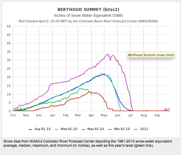
The message from the NRCS is no surprise to Coyote Gulch readers. We’ve been chronicling the precipitous decline in snowpack over the past month. Click on the thumbnail graphics for the latest snowpack map and table of snowpack and storage numbers for April 1, 2012, from the Natural Resources Conservation Service, as well as the Ogive of the Berthoud Pass Snotel (Climate Prediction Center via National Geographic). Here’s the release from the Natural Resources Conservation Service (Mage Skordahl):
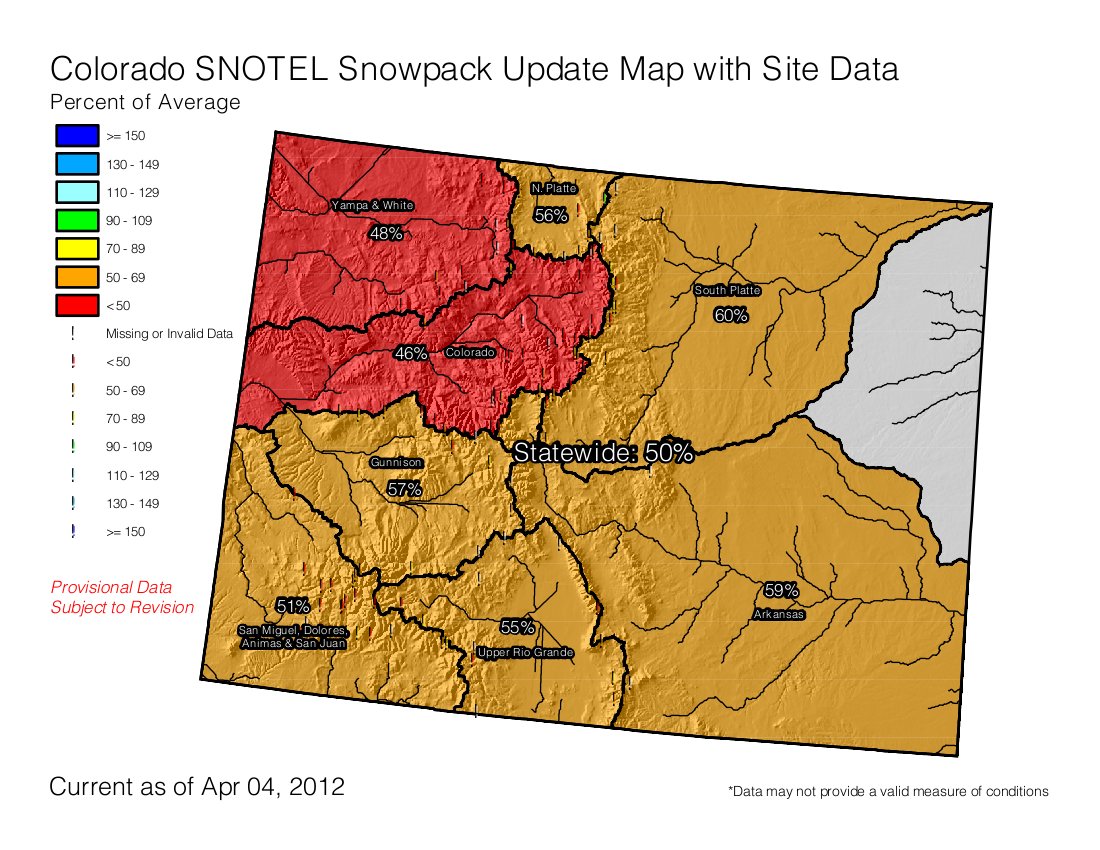
The reprieve due to average or above average snow accumulation in February and the resulting boost in snowpack totals across the state was short lived. March brought dry, warm and windy weather to Colorado resulting in significant declines in the snowpack. According to Phyllis Ann Philipps, State Conservationist with the Natural Resources Conservation Service (NRCS), the latest snow surveys conducted on April 1, show that statewide snowpack has fallen to a paltry 52 percent of average. This is a decrease of 29 percentage points from the 81 percent of average measured on March 1. Statewide snowpack conditions have not been this low since 2002 when the snowpack on April 1 was also reported to be just 52 percent of average. Luckily Colorado’s reservoir storage is in better condition than it was in 2002; storage volumes statewide were reported at 108 percent of average at the end of March.
All major basins in the state reported significant drops in snowpack percentages over the last month, resulting from well below average snowfall and precipitation and warmer than average temperatures. The combined Yampa and White River basins and the Colorado River basin are both reporting snowpack’s that are less than 50 percent of average; 47 and 49 percent of average respectively. The South Platte River basin’s snowpack, while still above the statewide average, saw the largest decrease from conditions reported at the beginning of March. The basin’s snowpack dropped a substantial 34 percentage points from 89 percent of average on March 1 to 55 percent of average on April 1. Snowpack totals in the rest of the major basins ranged from 53 to 57 percent of average.
In an average winter the state receives around 20 percent of its seasonal snow accumulation in March. This winter however, March precipitation recorded at SNOTEL sites was well below average with monthly statewide totals at just 29 percent of average and instead of continuing to accumulate snow, data from SNOTEL sites revealed a snowpack beginning to melt. With April 12, the average date the snowpack reaches its peak, just around the corner there is very little hope for significant improvements to snowpack conditions prior to the spring-summer runoff season.
As of April 1, streamflow forecasts across Colorado have decreased by 20 to 40 percent of average from those issued last month. This closely mirrors the decline in snowpack percentages observed across the state. At this point all major basins in Colorado are expected to receive well below average runoff this spring and summer.
The bright spot in this month’s water supply report is that reservoir storage continues to track at near to above average volumes across the state. This stored water should help alleviate late-summer shortages.
More coverage from Bob Berwyn writing for the Summit County Citizens Voice. From the article:
Specifically, the snowpack declined by 29 percent between March 1 and April 1 during a month that usually delivers 20 percent of the total annual snowfall. All major river basins reported declines, with the lowest levels in the Yampa/White River Basin and the Colorado River Basin, both now well below 50 percent of average.
The South Platte River Basin, critical for water supplies in the Denver Metro area, saw the largest drop, falling 24 percent from 89 percent of average on March 1 to just 55 percent of average on April 1.
Jennifer Pitt (Environmental Defense Fund via National Geographic) is asking the question, Can Lack of Snow in Colorado River Basin Lead to a More Sustainable Path?. Here’s an excerpt:
If 2012 kicks off a series of dry years similar to those of 2000-2010, shortages will be unavoidable in the Lower Basin. Worse, the impact of another extended drought would be magnified by the fact that reservoirs in the basin are only 64 percent filled today, while they were completely full when the last drought started.
An extended drought starting in 2012 could drain so much water from Lake Mead as to threaten the ability of Las Vegas to access what amounts to 90 percent of its developed supply, just as it could threaten the ability of the Upper Basin to make downstream deliveries required under the Colorado River Compact. These would be untenable impacts, and certain to cause legal chaos and confusion unless the federal government, states, water users and other stakeholders start to work now on additional agreements that implement more conservation and allow more flexibility in times of extended drought.
Until fairly recently, water managers using Colorado River supplies would look to divert more water from the river. Because annual use of Colorado River water has reached (even perhaps exceeded) the annual average supply, today’s central challenges for water managers are to manage demands (through conservation) and to help facilitate more flexibility in the use of the basin’s water, such as voluntary markets, while avoiding economic and environmental damages. For many (but certainly not all) water managers in the basin, it’s a new – and difficult – way of doing business.
The bare mountaintops of 2012, and the possibility of more years like it, are certain to make the jobs of water managers more challenging. Scarcity will increase competition for water, and prices are sure to rise. But it’s also possible that this year’s dry conditions, coming so soon after the dry conditions of 2002, will continue to shift public awareness and opinion towards more support of these new ways.
As those of us who depend on the Colorado River increasingly come to recognize that extreme variability is ‘the new normal,’ water managers could find a public more willing to adapt. We need an honest discussion about the trade-offs we face, and the opportunities to do more with the water we already have.
From the Summit County Citizens Voice (Bob Berwyn):
This past month may not have been the driest March ever in the high country, but it was very close. At the official National Weather Service in Dillon, there was measurable precipitation on only four days (March 2,3,4 and 19), adding up to just 3 inches of snow and a paltry 0.20 inches of water, compared to the average 1.42 inches of water and 22 inches of snow.
From the Summit County Citizens Voice (Bob Berwyn):
Based on experimental forecasting, odds are close to 40 percent that La Niña will return for a third winter, according to Boulder-based NOAA climate scientist Klaus Wolter, who emphasized that’s not the official outlook from NOAA or the Climate Prediction Center.
A triple La Niña could spell trouble for an already dry Colorado, as three-year La Niña events are statistically linked with some the driest conditions on record in Colorado, including a historic mid-1950s drought, the mid-1970s drought that prompted ski resorts to start making snow, as well as the drought in the early 2000s that culminated with the ultra-dry year of 2002, when Dillon Reservoir nearly disappeared in a cloud of dust.
The best hope for a moisture turn-around would be a sudden switch to El Niño, which some climate models are predicting, but Wolter calculates that there’s only a 20 percent chance of that happening.