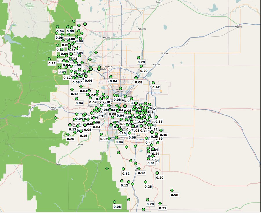
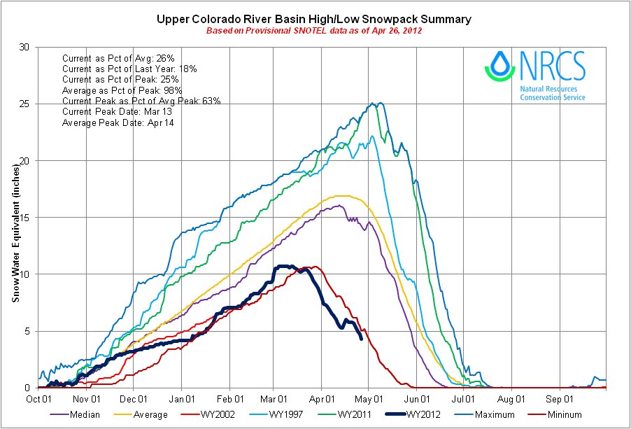
Click on the thumbnail graphics for the current statewide snowpack map and the Basin High/Low graph for the Upper Colorado River basin from the Natural Resources Conservation Service. I’ve also posted a screen shot of the new Urban Drainage and Flood Control District alert map for the past 24 hours. Depending on where you were in the Denver Metro area yesterday evening you could have seen good moisture from the thunderstorms that rolled through. For example, 47 hundredths near Denver International Airport.
From the Grand Junction Free Press (Hannah Holm):
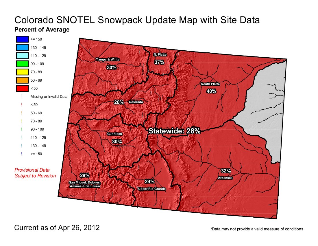
As of April 24, the Colorado River Basin snowpack in Colorado held just 38% of the water content it would have on this date in an average year; the Gunnison River Basin held 34% of its average water content for this date. In 2002, the last extremely dry year, the Colorado River snowpack was doing about the same at this point; the Gunnison was a bit worse at 25%.
We’re lucky that this historically dry water year is following a historically wet one last year, which provided exciting high river flows, filled local reservoirs, and raised levels in Lake Powell, the “bank account” used by Colorado, Utah, Wyoming and New Mexico to help meet obligations to our downstream neighbors in Arizona, California, Nevada and Mexico.
As for next year, who knows? Variability from year to year is the norm, and predictions from one year to the next are notoriously unreliable. There are reasons to believe we could face more challenging times ahead.
A recent Bureau of Reclamation study of water supply in the Colorado River Basin found that both ancient tree rings and climate change models seem to indicate that our long-term future could hold both longer and more severe droughts than have been observed over the past century.
Meanwhile, water consumption doesn’t seem to be going anywhere but up. The state demographer projects that by 2050, Colorado’s population could nearly double, to about 10 million people. Where will this water come from? State water planners and groups of stakeholders in each of the state’s major river basins (Basin Roundtables) are wrestling with this question right now. Solutions include taking more water from the Colorado River’s headwaters to the Front Range, taking more water from agriculture, and increasing conservation — each of which faces different hurdles and has different impacts on state and local economies and quality of life.
The public can learn more about the current drought and the state’s long-term water planning efforts at the annual Mesa County State of the Rivers Meeting set for Wednesday, May 2, 6:30-8:15 p.m., at the University Center Ballroom of Colorado Mesa University. The event is sponsored by the Colorado River District and the Water Center at CMU.
Water Center at CMU is working with the Colorado and Gunnison Basin Roundtables to raise awareness about how water works in our region. The Roundtables are groups of stakeholders engaged in local and statewide water planning. To learn more about the basin roundtables and statewide water planning, go to www.coloradomesa.edu/WaterCenter.
From the Summit County Citizens Voice (Bob Berwyn):
So far this year, wildfires have burned only about a third of the acreage compared to the same time period last year.
“We are ready to meet the challenge,” said Agriculture Secretary Tom Vilsack. “The National Cohesive Wildland Fire Management Strategy provides a strong, new blueprint to ensure community safety and the restoration of ecosystems to benefit all Americans, especially those who live in the urban-wildland interface areas. Our concern does not stop at the border of federal lands, but rather a strategy that is an all-lands approach for safety and wildfire management,” he said.
The remarks came during a teleconference Thursday, when Interior Secretary Ken Salazar also responded to a letter from Colorado senators Mark Udall and Michael Bennet asking for a review of federal prescribed burn policies in the wake of the deadly Lower North Fork Fire.
“Both the Forest Service and the BLM have a very careful, meticulous process for determining how to manage prescibed fires … We feel very confident that if the process is followed, we can successfully manage prescribed fires. We will be responding to senators Udall and Bennet,” Salazar said.
From The Durango Herald (Dale Rodebaugh):
“It’s not as severe as in 2002, but drought is expanding and becoming more intense,” Jim Pringle said during a stop at The Durango Herald. “But conditions since haven’t been as bad as they are now.”
Justin Kincaid, the U.S. Forest Service’s fire management officer in Durango, agreed that the situation looks grim.
“We could be in our fire season a month early – mid-April instead of mid-May,” Kincaid said. “We have to wait for the results of the spring rains.”[…]
Meteorologists measure drought by various standards, including soil moisture, water content of the snowpack, stream flow, water stored in reservoirs, the moisture level of fuels such as trees and grass and the amount of precipitation other than snow, Pringle said. By way of example, Pringle said, the snow-water equivalent at Vallecito on April 16 was 23 percent of average; at Cascade, 7 percent of average; at Mancos, 5 percent of average; and 16 percent of average at Molas Lake. On the same date in 2002, there were only zeros in the snow-water equivalent chart for Mancos, Cascade and Vallecito and 9 percent at Molas Lake. Even at the Wolf Creek Pass summit, which had a wet 2011-2012 winter, the snow-water equivalent was only 65 percent of average. In 2002, the percent of average was 29.