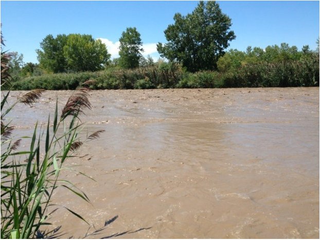
Say hello to the Middle Colorado River Watershed Council #ColoradoRiver

coloradoriverbasincgs

From the Glenwood Springs Post Independent (John Colson):

Known as the Middle Colorado Watershed Council, it was formed in 2009 with funding mainly from the Colorado Department of Public Health and Environment, and currently has just one paid employee — Coordinator Laurie Rink of Carbondale.

The organization has been undergoing a kind of birthing process since it was formed. Organizers are applying for nonprofit status and meet frequently to discuss problems and issues unique to the Colorado River drainage, and to hold public events to familiarize the local citizenry with the Council and its mission.

Rink, as part of the Council’s outreach to other organizations and agencies, gave a presentation on Thursday night to the Garfield County Energy Advisory Board (EAB) about the Council, its goals and its structure.

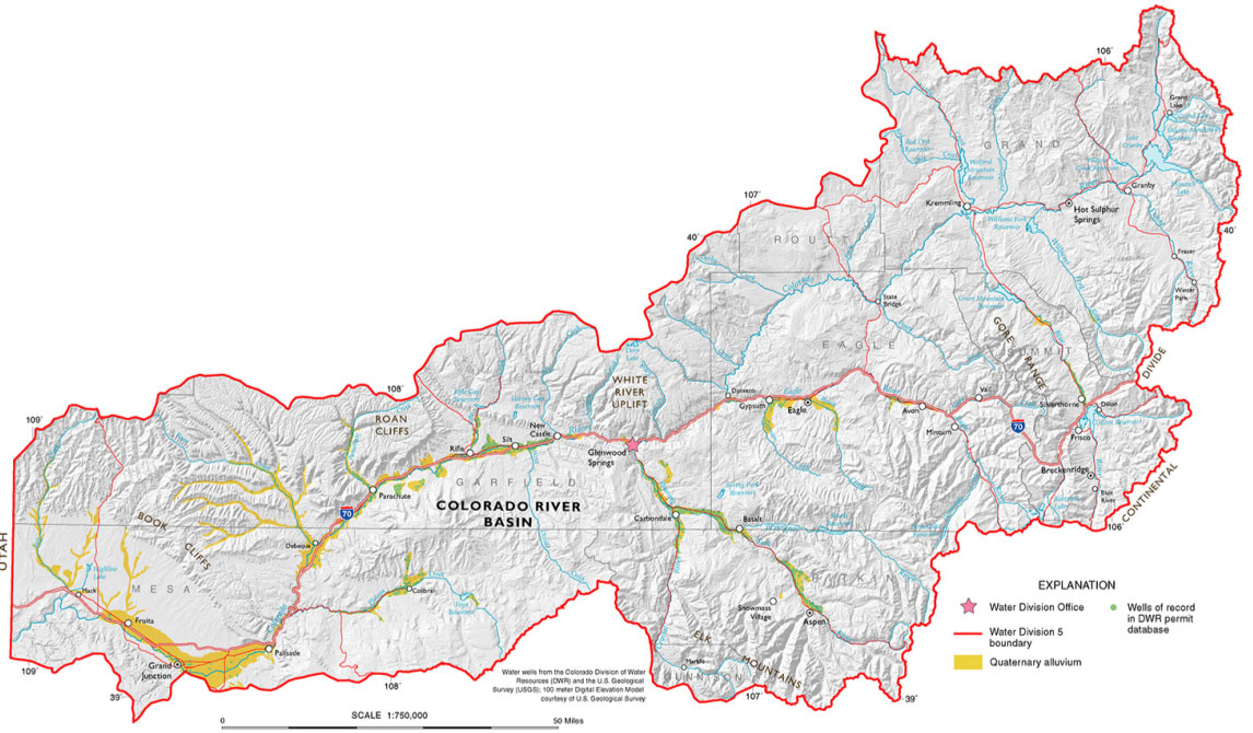
The Colorado River watershed, Rink told the EAB and an audience of roughly a dozen members of the public, covers approximately 2,000 square miles of terrain from the eastern end of Glenwood Canyon to the town of De Beque.

The boundary of the watershed, she said, is largely identical to the contours of Garfield County.

The watershed encompasses about 7,500 linear miles of rivers, creeks and streams, she said, but not the Roaring Fork River drainage. Although the Roaring Fork is a tributary to the Colorado, it is watched over by another organization, the Roaring Fork Conservancy in Basalt.

All that water, Rink said, is generally used for recreation, agriculture, the energy industry, wildlife, and drinking water.

More Colorado River Basin coverage here and here.

Environmental Entrepreneurs report — ‘Colorado Water Supply and Climate Change: A Business Perspective’

finance_trader_25_percent_down_fall_share_discount-300x250.jpg

Click here to read the report. Click here to go to the website. Here’s an excerpt from the report:

As Colorado business leaders, the members of the rocky Mountain chapter of environmental entrepreneurs (e2) are concerned by the mounting evidence that climate change will make it harder to meet the state’s future water needs, that these risks are not yet sufficiently understood, and that not enough is being done to reduce them.

We call on the governor and other key public officials to ensure that the new State Water plan being developed includes specific measures to adequately reduce Colorado’s water risks, as magnified by climate change. our central recommendation is that the state government, water providers, and the private sector work together to reduce per capita municipal and industrial (M&I) water use by 25 percent by 2025 and by 50 percent by 2050. this is a more ambitious goal than anyone has yet proposed for this state. But it is the action that is proportionate to the challenge. It is realistically achievable, as evidence from Colorado and other western states shows. and it is the most reliable, flexible, and affordable way to meet our water needs in a changed future…

Key Recommendations

• The governor should set a goal of reducing per capita urban water use by 25 percent by 2025 and by 50 percent by 2050, compared with 2010 levels. the goal should be included in the State Water plan and met by all water providers.
• The state should require all water providers to adopt water rates that create incentives for water conservation.
• The plan should include a scenario of both climate change-driven increases in demand and potential legal curtailments on water supplies.
• The state should expand water reuse, and require reuse of fluids used in hydraulic fracturing (fracking) oil and gas operations.

More Colorado Water Plan coverage here.

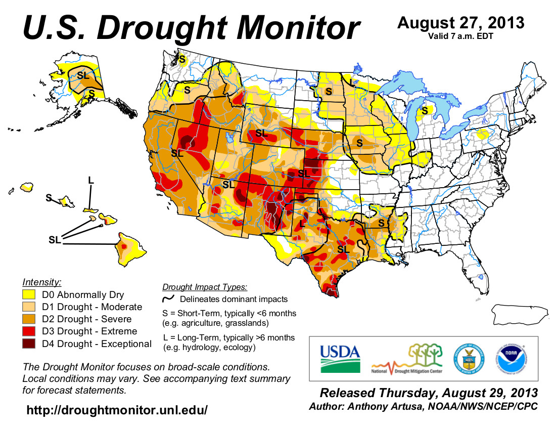
Drought news #COdrought

usdroughtmonitor09032013.jpg

Here’s an excerpt from the summary from the US Drought Monitor website:

Weather Summary: The week commenced with high pressure over the Southeast and storm systems traversing across the northern U.S. As the week progressed, the high pressure system traveled westward, settling over the south-central Plains while a trough of low pressure and associated cold front brought scattered showers and thunderstorms to the eastern third of the Nation. A weak frontal system generated scattered showers in the Pacific Northwest. In the Southwest, tropical moisture from Tropical Storm Juliette (which dissipated off central Baja California) helped to fuel the southwest monsoon in Arizona, Nevada, Utah, and southern Idaho. Decent showers also fell on parts of New Mexico and Colorado. Hit and miss showers also fell on parts of the northern Plains and upper Midwest, the central Great Plains, and south-central Texas. Unsettled weather and decent precipitation also affected most of Alaska, with many stations reporting weekly totals exceeding 2 inches in southwestern and south-central sections of the state. In contrast, little or no rain fell on most of California, Oregon, and eastern Washington, parts of the Plains, most of the Mississippi Valley, and much of Hawaii. Weekly temperatures averaged well above normal (6 to 10 degF) across much of the contiguous U.S., with the exception of seasonable readings in the desert Southwest and Southeast. Highs topped triple-digits in the southern two-thirds of the Plains, southern Iowa and northern Missouri…

Northern and Central Great Plains: Most of the Dakotas reported light to moderate (0.5 to 1.5 inches) of rain, with a few spots in southern North Dakota and northern South Dakota measuring over 2 inches. The rains were enough to keep conditions status-quo, except where the heavier rains fell. In the latter case, D0 was alleviated along most of the western D0 edge of the Dakotas, with D1 to D0 in south-central North Dakota. A slight increase in D0 was made in extreme southeastern South Dakota where many days in the 90’sF have started to prematurely brown the crops. USGS stream flows are still near or above normal at most sites in the Dakotas. No changes were made in Nebraska and Kansas, except for a small 1-category improvement (D1 to D0; D0 to nothing) in extreme sections of southeast Nebraska, northeast Kansas, southwest Iowa, and northwest Missouri, where 1.5 to 3.2 inches fell.

Southern Great Plains: In Oklahoma and Texas, several weeks of mostly dry and warm weather (highs in the 100sF) have diminished the surplus rains from a wet and cool July (in both states) and a wet and cool early August (in Oklahoma). As a result, D0 returned across northern Oklahoma, while a 1-category downgrade occurred across southern Oklahoma as August was a no-show in the southern third of the state. In Texas, a band of light to moderate, with some locally heavy (>2 inches) rain, fell from near Del Rio northeastward into southeastern Oklahoma, and along the Gulf Coast. Some slight improvements were made where the heaviest totals occurred. In eastern Texas, little or no rain fell, and some deterioration was made.

The Southwest: A continued robust summer monsoon, aided by a northward fetch of moisture from former Tropical Storms Juliette and Kiko (both dissipated west of central Baja California), produced widespread showers and thundershowers to much of Arizona, New Mexico, Nevada, Utah, and northward into parts of the West (Idaho, Wyoming, and Colorado). Numerous locations in southern Nevada and Arizona measured over 2 inches of rain, while 1 to 2 inches were common in central Nevada, western and central New Mexico, central Utah, and most of Arizona. Although short-term shortages have been greatly eased or eliminated, long-term deficits still lingered. To accommodate the long-term impacts, only slight improvements were made where the greatest rains fell and the long-term deficits (180-days) were noticeably reduced. For example, enough rain has fallen during the past 6-months in western New Mexico and southwestern Texas that surpluses have accumulated, hence the D2 to D1 and D0 to nothing upgrade, respectively. Similarly in south-central Nevada, D3 and D2 was improved where there was heavy weekly rains and the 180-day deficits were noticeably diminished. The same holds true in western and central Arizona where D2 and D1 were decreased. On Sep. 2, even many USGS stream flow gauges in western New Mexico, central Arizona, southern Nevada, and southwestern Utah flowed at the 90th percentile at 1- and 7-days. The Impacts line was redrawn to depict improved short-term conditions from the robust monsoon, making the long-term (hydrologic) effects causing most of the negative impacts.

The West: Moderate to heavy (1 to 3 inches) rains fell on the Pacific Northwest Coast, effectively eliminating the D0(S) in western Washington. Southwest monsoonal showers also spread northward into southeastern Idaho, central Colorado, and southeastern Wyoming, dropping enough rain (1 to 2.5 inches) to improve D2 to D1 in southeastern Idaho, and 1-category improvement of parts of the D3 and D2 areas in southeastern Wyoming. In addition, 180-day surpluses were present, justifying an upgrade from D1 to D0. Elsewhere, little or no rain fell, and conditions were kept status-quo. An exception was made in north-central Oregon (D0 and D1) where a re-assessment of 90- to 180-day deficiencies were made. The data and products yielded a surplus at those time periods, hence the D1 was improved to D0 (eastern Wheeler county) and D0 removed (from Wasco, Jefferson, Sherman, and western Wheeler counties).

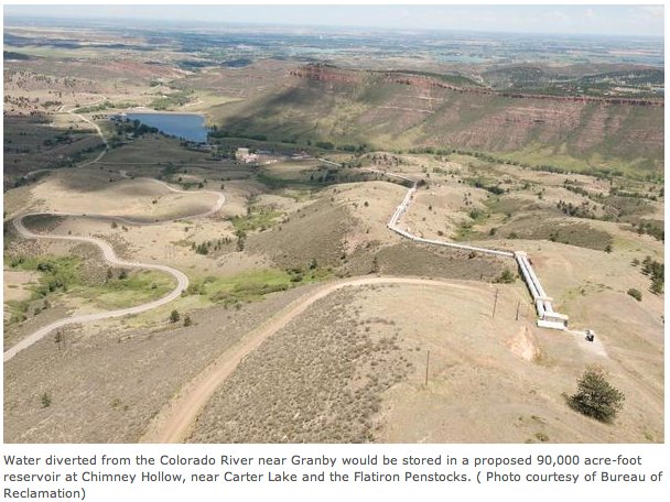
Windy Gap Firming Project update: Analysis paralysis #ColoradoRiver

chimneyhollowsitedpviareclamation.jpg

From the Northern Colorado Business Report (Joshua Zaffos):

Begun in 2003 and scheduled to be up and running by 2011, the project, known as the Windy Gap Firming Project, like many others across the state, still is mired in regulatory delays. Whether or when Windy Gap will be built is still unclear 10 years after the first regulatory review took place.

Three other major water projects face similar delays and uncertainty…

Northern is working with 13 Northern Colorado water providers to develop the latest phase of Windy Gap, which is designed to serve 60,000 households.

Northern Water initially submitted the project for environmental he project for environmental review to the U.S. Bureau of Reclamation in 2003. Through the National Environmental Policy Act (NEPA), a project’s environmental impacts are reviewed during several stages of technical analysis and public comment. A 2005 Northern Water fact sheet projected a final “record of decision” could come by the end of that year, meaning construction could start soon after and the reservoir would be ready by 2011.

That forecast was wildly optimistic. The bureau didn’t issue a final environmental impact statement, a key step in NEPA, until late 2011. Reviews by federal and state scientists, environmental groups and western Colorado interests each triggered calls for mitigation and changes that added months and then years of delay…

Project partners have spent $12 million to date just on permitting, agreed to pay millions more than expected for environmental mitigation and watched the cost estimate jump nearly 28 percent, from $223 million to $285 million. That’s roughly $1,033 per household.

Similar delays and cost overruns have plagued nearly every other major Colorado water-development project that has sought regulatory approval since the 1990 defeat of Two Forks Dam. Proposed by Denver Water, the $1 billion Two Forks project passed through NEPA with government approval before the Environmental Protection Agency vetoed the decision because of study inadequacies and unresolved water-quality impacts.

After more than a decade of drought and a new wave of growth, water utility planners believe the project review system is broken and must be fixed. Legal experts and environmental watchdogs say the projects themselves are outdated in concept and that utilities need to rethink how they obtain, store and deliver water…

Drager has had to ask Windy Gap Firming Project partners for an extra $1 million four separate times in the past five years to pay for unexpected mitigation. Consideration of the upper Colorado River as a federally designated wild and scenic river triggered additional analysis. State fish and wildlife managers required further mitigation plans, including a study for a fish bypass around Windy Gap Reservoir. Northern Water also had to agree to enhance river habitat and operate water diversions to support endangered fish in the Colorado River. The EPA filed comments that led to further changes. When an end seemed near in June 2012, Grand County exercised its “1041 powers,” requiring a new permit and an agreement from partners to improve clarity for Grand Lake, which has deteriorated in part because of Northern’s water diversions. Now mostly settled, the Grand Lake revision marked the fifth major project stoppage.

“It’s not just NEPA,” Drager said. “There are a whole bunch of federal requirements – the Endangered Species Act, the Clean Water Act – and then you’ve got a group of state laws which don’t always work well with the federal laws. So, it’s very hard to know when is the last step. When are you done?”

Communities and water districts that are footing the bill have weathered the delays and tacked-on costs so far. The Little Thompson Water District in Berthoud has avoided charging existing customers extra, said district manager Jim Hibbard, because one developer is shouldering the district’s share of the costs and adding those dollars to the cost of new homes he is building. “Probably the most significant impact is the costs of the project keep going up,” Hibbard said.

The city and county of Broomfield, another project partner, has used money from water tap fees for its share of the project and paid the additional costs with reserve funds stashed away for such purposes, said public works director David Allen. But even with the added mitigation and expenses, both managers say the project remains an inexpensive and preferred alternative to purchasing shares in existing water projects, such as the Colorado-Big Thompson system or buying out farmers’ water rights and drying up local agriculture…

Since Two Forks, federal agencies involved with NEPA reviews are “gun shy,” said Dave Little, planning director for Denver Water, which also has spent more than 10 years seeking approval for its own major water project, the Moffat Collection System…

Cost overruns may look excessive, but initial estimates often come in low to ease early acceptance of a project, [Western Resource Advocates Drew Beckwith] said, adding that some delays are squarely on the shoulders of project managers who haven’t adequately analyzed certain impacts or mitigation actions. “I don’t think anyone is really happy with the way the process works right now,” Beckwith said. “Utilities think it takes too long. Conservationists would say there’s not enough good input.”

He said he would like to see a more open-ended, upfront approach to water-supply challenges instead of a water agency selecting a preferred solution and then following a “decide and defend” strategy.

The changing pressures from environmental organizations also have factored into delays. The proposed $140 million Chatfield Reservoir Reallocation southwest of Denver, another storage expansion project under consideration, has received support from several conservation groups, including Western Resource Advocates, because it avoids building an entirely new reservoir, but the Audubon Society of Greater Denver opposes the development because it would flood wetlands and other bird habitat…

The plodding pace of regulatory review may remain an annoying reality – unless a water utility can devise ways to provide water without massive new storage or delivery pipelines.

Aurora did just that. A decade ago, facing water shortages and drought, Aurora Water planners recognized the need for swift action to protect system reliability and service for existing customers. The utility decided to build its Prairie Waters Project, an $854 million pipeline and treatment facility that would allow the city to reuse 50,000 acre-feet of water annually and meet its water demands through 2030. Since the project didn’t include new storage, managers avoided prolonged federal review, said Darrell Hogan, the project manager, and Aurora Water further expedited its work by tunneling under waterways. To have disturbed the waterways otherwise would have required Clean Water Act 404 permits. Hogan said the project didn’t evade environmental protections; planners still consulted with government scientists and conservationists, and had to acquire more than 400 permits for local construction and operations. However, working around the federal system facilitated progress. Prairie Waters went from concept to completion in less than six years, delivering water in October 2010 on time and under budget.

More Windy Gap coverage here and here.

Drought news: Colorado Springs meets conservation goal for the water year #COdrought

From The Colorado Springs Gazette (Monica Mendoza):

Residents, watering their lawns only two days a week and helped by summer rain, used 5.8 billion gallons less than last summer and as of Thursday have met the city’s water-savings goal. That leaves 1.8 years of water in storage, “meaning if we never got another drop into the system, there is enough water in storage to protect residents’ health and safety for 1.8 years,” said Patrice Lehermeier, Colorado Springs Utilities spokeswoman…

It was likely a combination of watering restrictions, higher water rates and lots of rain that helped the city meet its goal three weeks early, Lehermeier said.

Now the city will wait on Mother Nature to deliver snow this winter – the melted snowpack is what fills the city’s reservoirs, Lehermeier said. But Colorado Springs Utilities water planners already are working on next summer’s water plan, which is likely to include watering restrictions and a new water savings goal.

More Colorado Springs Utilities coverage here.

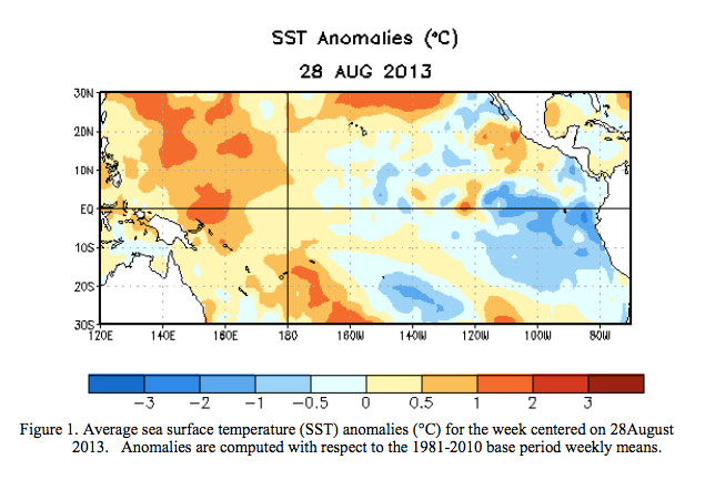
The latest ENSO discussion is hot off the presses from the CPC — ENSO neutral through spring #COdrought

Average sea surface temperature anomalies centered on August 28 -- Graphic/CPC
Average sea surface temperature anomalies centered on August 28 — Graphic/CPC

Click here to read the discussion. Here’s an excerpt:

Most model forecasts continue to predict ENSO-neutral (Niño-3.4 index between -0.5°C and 0.5°C) into the Northern Hemisphere spring 2014.

The 2013 Sustaining Colorado Watersheds Conference agenda is now online

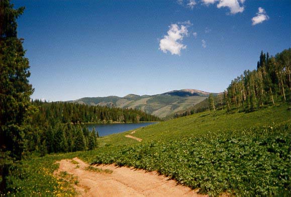
ledereservoirgypsum.jpg

Click here to read about the conference and register.

Drought news: ‘We [Ouray County] are nowhere near making up from last year’s drought’ — #COdrought

usdroughtmonitor08272013.jpg

From The Watch (Samantha Wright):

In Ouray, National Weather Service recorder Karen Risch reported, “Historically, we should be at 15.28 inches for the calendar year, and we are currently at 15.10. We have made up 2.5 inches in last two months. It has been a pretty dramatic turnaround.” The month of July typically brings 2.13 inches of precipitation to Ouray, Risch said, compared to 3.28 inches in 2013. August’s average is 2.33 inches, compared to 3.58 inches this year.

But those figures tell only part of the story. The National Weather Service measures annual accumulated precipitation in two ways – by calendar year and by water year. The water year is measured annually from October through September. And a month shy of the conclusion of the 2012-13 water year, Ouray is still four inches below average. While the town’s historical annual precipitation per water year is 23.05 inches, Ouray has received only 19.19 inches of precipitation so far for the current water year. In short, “We are nowhere near making up from last year’s drought,” Risch said…

Forecaster Jim Daniels out of the National Weather Service’s Grand Junction office said that a similar story is unfolding across the region, with above-average monsoonal rainfall in July and August helping to bring accumulation to near-normal to slightly above-normal levels for this calendar year…

Weather observers at the Montrose Airport measured 2.08 inches of rainfall in July, and 1.29 inches in August, considerably up from the average monthly levels of .83 inches and .88 inches, respectively. Total precipitation for the calendar year so far, measured at the same location from January through August 2013, is 6.02 inches, compared to an average of 4.65.

Ridgway, like Ouray, is still slightly below average for the calendar year, with an accumulated total of 10.18 inches of precipitation from January through August, compared to an average of 11.31.

Colorado Water Plan: ‘We don’t have enough water is the bottom line’ — Karn Stiegelmeier #ColoradoRiver

newsupplydevelopmentconceptcwcb2013.jpg

From the Summit Daily News (Breeana Laughlin):

Governor John Hickenlooper sent an executive order in May calling for river basin roundtable groups throughout the state to come up with plans to resolve gaps in the water supply by December 2014. Each of these documents will come together to form the Colorado Water Plan. “We don’t have enough water is the bottom line,” said Summit County commissioner Karn Stiegelmeier. “Each group has identified gaps and unmet needs for agriculture and municipalities, as well as non-consumptive uses — which includes the environment and recreation.”

Stiegelmeier sits on the Colorado Basin Roundtable, which represents Summit County water interests, among others…

The county commissioner said her group is also working to make sure other roundtable group’s plans don’t infringe on the Colorado Basin Roundtable plan. “Because we are the target, we are also going to try to be productive in resolving the state’s gaps,” she said. “Otherwise, they have the political power to do what is most scary to us — streamlining approval processes — which would take away local control over water projects. That’s our biggest concern.”

In addition to the Colorado Basin Roundtable, the county commissioner sits on the Northwest Colorado Council of Governments (NWCCOG) Water Quality and Quantity Committee. This group strives to bring individual governments and agencies together to speak with a unified voice on water issues. It includes members from Summit, Grand, Gunnison, Pitkin and parts of Park County, as well as cities and water sanitation groups within these counties. “It started as an effort to get county and municipal governments on the same page to be a stronger advocate to keep water on the West Slope, and mitigate the damage from trans-mountain diversions,” said Torie Jarvis, co-director at the NWCCOG Water Quality and Quantity Committee. This group has been focused on the implementation of the Colorado Water Plan, and has developed a number of principles to represent the interests of stakeholders on the West Slope.

More Colorado Water Plan coverage here.

Drought news: Breckenridge precip is ahead of the game for the water year after a wet August #COdrought

usdroughtmonitor08272013.jpg

From the Summit County Citizens Voice (Bob Berwyn):

An extended monsoon season lifted August precipitation in Breckenridge to well above average, as weather-watcher Rick Bly tallied 4.22 inches of water for the month. The average rainfall for August is 2.26 inches; August 2013 was the wettest August since 1984. “We had a good month for precipitation,” Bly said, adding that the rainfall often came at night, when it’s even more beneficial because it has a chance to sink into the ground before evaporating.

All in all, the 2012 water year has been up and down, with a “desperately dry October and November, according to Bly, followed by a so-so early winter and a gangbusters spring, with drought-busting snows in April and May. Last month’s rainfall also pushed the year-to-date total to above average, at 19.38 inches compared to the average 16.83 inches. Even if September ends up being very dry, Breckenridge will end up the water year (Oct. 1 – Sept. 30) above average, he said…

Precipitation in August was also above average in Dillon, where weather observers with Denver Water tallied 2.13 inches for the month (average 1.77 inches). There was measurable precipitation on all but 12 days of the month at the Dillon site, with 0.34 inches on Aug. 5, the wettest day of the month.

Weekly Climate, Water and Drought Assessment of the Upper Colorado River Basin #ColoradoRiver

August precipitation as a percent of normal for the Upper Colorado River Basin -- photo/Colorado Climate Center
August precipitation as a percent of normal for the Upper Colorado River Basin — photo/Colorado Climate Center

Click here to read the current assessment.

US Rep Cory Gardner’s permitting bill has not been introduced yet but opposition has already surfaced

nisp2.jpg

From the Northern Colorado Business Report (Steve Lynn):

Rep. Cory Gardner responded to criticism Tuesday from an environmental group, saying that opponents mischaracterized newly proposed legislation on water storage.

Gardner, said his bill would require regulators to approve or deny permits for reservoir projects within 270 days after a governor sends a letter to the federal government supporting a project. The congressman has criticized the U.S. Army Corps of Engineers for taking too long to approve the Northern Integrated Supply Project.

“Conservation is an important part of our water future in Colorado,” Gardner said. “But we also have to store more water.”[…]

Fort Collins-based Save the Poudre said Tuesday that Gardner’s bill would “gut” the National Environmental Policy Act and create a new bureaucracy within the Army Corps of Engineers called the “Office of Water Storage.”

“The National Environmental Policy Act is very clear: It requires sound science, and sound science takes time,” Save the Poudre director Gary Wockner said. “By forcing permitting in a certain time period, Congressman Gardner would be undermining and Gardner would be undermining and gutting the National Environmental Policy Act.”

Here’s the release from Congressman Gardner’s office:

Rep. Cory Gardner (R-CO) led a water storage tour in Weld County this morning and announced that he would be introducing new legislation when Congress returns from its summer work period. Gardner said:

“Thank you to the many local and state officials who participated in the water storage tour this morning in Weld County and joined me in discussing the need for increased water storage in Colorado. The large presence of leaders in attendance demonstrates the need for immediate action on this issue.

“Water is one of the main drivers of economic growth in Colorado, and every industry in the state relies on this vital resource. I wish the federal government fostered a regulatory environment in which tours like the one I led this morning were not necessary, but that is simply not the case. The federal government has continued to stall important projects like NISP because of a permitting process in Washington, D.C. that creates bureaucratic regulatory barriers.

“The ongoing problems with water storage are why I plan to introduce a bill when Congress returns from its summer work period that fixes the broken permitting system. The legislation would establish an Office of Water Storage at the Army Corps of Engineers that would serve as the central hub for permitting decisions. This new office would coordinate with all agencies involved in the permitting and approval process for storage. The legislation would not call for circumvention of environmental reviews, but rather it sets a workable timeframe for an initial decision to be made on whether or not a project can move forward.

“I stand ready to work with any willing partners on this issue that is so important to all of Colorado and its communities.”

Drought news: Cortez precipitation way above average for August, drought lingers #COdrought

usdroughtmonitor08272013.jpg

From the Cortez Journal (Tobie Baker):

“We were way above normal for the month of August,” said local meteorologist Jim Andrus. Standard rainfall for the area in August is 1.37 inches, but Cortez received 3.69 inches of rain last month, nearly three times the average…

Due to the August precipitation, Cortez has surpassed average year-to-date levels of precipitation. Andrus said normal precipitation for the year at this time is 8.27 inches. So far, Andrus has recorded 8.64 inches of rain in 2013. Earlier in the month, Tropical Storm Ivo stalled off the coast of the Baja Peninsula dropping nearly two inches of rain on the area within a 48-hour period.

Despite above average rains, Andrus warned drought conditions would persist until water levels at Lake Mead and Lake Powell return to normal. Both reservoirs remain well below normal levels, he added.

A National Weather Service cooperative weather observer for Cortez for the past 16 years, Andrus said Montezuma County has experienced repeating drought conditions since 1997. He’s recorded below normal levels of precipitation over a majority of the last 15 years.

The proposed Piñon Ridge uranium mill could be online in 2017

doloresrivercanyon.jpg

From the Cortez Journal (Jim Mimiaga):

The Pinon Ridge Mill has cleared several major permit hurdles and survived court challenges from environmental groups. Its proposed location is in Paradox Valley between Naturita and Bedrock off Colorado Highway 90…

Energy Fuels Resources Corp., a Canadian-based company with a main office in Littleton, Colo., has been working towards building the $150 million plant for the last six years. EF also owns the White Mesa Mill, south of Blanding, Utah, which is currently the only operating uranium mill in the country.

The new Pinon Ridge mill would process uranium ore using an acid leach process to produce yellowcake, a concentrated uranium product that is fabricated into fuel rods for nuclear reactors. The mill is expected to process 500 tons a day of uranium ore from re-opened mines on the Colorado Plateau, Uravan Mineral Belt, and Arizona Strip.

The Environmental Protection Agency has granted EF a permit for the construction of tailings impoundment and evaporation ponds. A radioactive materials license was approved by the Colorado Department of Public Health and Environment in April for the project…

The company still needs a construction permit from CDPHE before the project can break ground. Pending approval of permits, construction of the mill could be completed by early 2017. Public comments on the construction permit will be accepted. For more information go to http://www.colorado.gov/cs/Satellite/CDPHE-Main/CBON/1251583470000

More Piñon Ridge uranium mill coverage here and here.

Statewide water plan: ‘I want to hear what pieces are important to you’ — Gail Schwartz

newsupplydevelopmentconceptcwcb2013.jpg

Here’s a guest column about Colorado’s water plan, written by State Senator Gail Schwartz running in the Glenwood Springs Post Independent. Senator Schwartz has been in the middle of water legislation for most of her time in the state legislature. Here’s an excerpt:

The state water plan will pave the way for water decisions that responsibly and predictably address future challenges. The governor’s executive order detailed that the plan must promote a productive economy that supports vibrant and sustainable cities, viable and productive agriculture, and a robust skiing, recreation and tourism industry. It must also incorporate efficient and effective water infrastructure planning while promoting smart land use and strong environmental protections that include healthy watersheds, rivers and streams, and wildlife.

The Colorado Water Conservation Board (CWCB) has been tasked with creating the Colorado Water Plan. The board must submit a draft of the plan to the governor’s office by Dec. 10, 2014, and a final plan by Dec. 10, 2015. The CWCB will incorporate the state’s Interbasin Compact Committee (IBCC) and nine Basin Roundtables recommendations to address regional long-term water needs.

As chair of the interim Water Resources Review Committee (WRRC), I will help ensure that the diverse voices of Colorado’s water community are heard during the development of this plan. The 10-member WRRC comprises legislators representing districts in each of the state’s major river basins. The committee has a full agenda as we are charged to review water issues and propose legislation. The WRRC will also remain actively engaged with the CWCB in development of the State Water Plan…

As charged, the water plan has a broad scope and will inevitably need to address difficult and contentious issues. I believe that we should first focus on conservation and efficiency both at the municipal/industrial level and in agriculture. Water conservation is an area with broad consensus. A recent public opinion study of Coloradans identified conservation as the most important water-related issue. Other studies have strikingly demonstrated that 80 percent of Coloradans favored conservation over new construction projects. In 2013, I sponsored SB13-19 which gives landowners a new tool to conserve water without injuring their water rights. New conservation and efficiency tools are needed in the State Water Plan as they stress wise use of our precious water resource.

Conservation may be just one piece of this larger puzzle, and I want to hear what pieces are important to you.

More statewide water plan coverage here.

Tapping the Rockies: Water for Beer

Leave the streams intact for beer and food. Sounds like a sound water policy.

The 3rd Annual Colorado Global Health and Water Symposium is September 28

Ogallala aquifer: Study forecasts future water levels of crucial agricultural aquifer

ogallalaaquiferriverbasins.jpg

Here’s the release from Kansas State University:

If current irrigation trends continue, 69 percent of the groundwater stored in the High Plains Aquifer of Kansas will be depleted in 50 years. But immediately reducing water use could extend the aquifer’s lifetime and increase net agricultural production through the year 2110.

Those findings are part of a recently published study by David Steward, professor of civil engineering, and colleagues at Kansas State University. The study investigates the future availability of groundwater in the High Plains Aquifer — also called the Ogallala Aquifer — and how reducing use would affect cattle and crops. The aquifer supplies 30 percent of the nation’s irrigated groundwater and serves as the most agriculturally important irrigation in Kansas.

“Tapping unsustainable groundwater stores for agricultural production in the High Plains Aquifer of Kansas, projections to 2110” appears in the scientific journal Proceedings of the National Academy of Sciences of the United States of America, or PNAS. The study took four years to complete and was funded by the National Science Foundation, the U.S. Department of Agriculture and Kansas State University’s Rural Transportation Institute.

“I think it’s generally understood that the groundwater levels are going down and that at some point in the future groundwater pumping rates are going to have to decrease,” Steward said. “However, there are lots of questions about how long the water will last, how long the aquifer will take to refill and what society can do.”

Steward conducted the study with Kansas State University’s Michael Apley, professor of clinical sciences and an expert in cattle production; Stephen Welch, professor of agronomy, who helped with a statistics method called bootstrapping; Scott Staggenborg, adjunct professor in agronomy who studies agricultural production methods; Paul Bruss, a 2011 master’s degree graduate in civil engineering; and Xiaoying Yang, a former postdoctoral research assistant who is now at Fudan University in China.

Using measurements of groundwater levels in the past and present day in those regions, Steward and colleagues developed a statistical model that projected groundwater declines in western Kansas for the next 100 years and the effect it will have to cattle and crops.

According to their model, researchers estimated that 3 percent of the aquifer’s water had been used by 1960. By 2010, 30 percent of the aquifer’s water had been tapped. An additional 39 percent of the aquifer’s reserve is projected to be used by 2060 — resulting in the loss of 69 percent of the aquifer’s groundwater given current use. Once depleted, the aquifer could take an average of 500-1,300 years to completely refill given current recharge rates, Steward said.

Although the High Plains Aquifer will continue declining, researchers anticipate even greater efficiencies in water use during the next 15-20 years.

“Society has been really smart about using water more efficiently, and it shows,” Steward said. “Water use efficiencies have increased by about 2 percent a year in Kansas, which means that every year we’re growing about 2 percent more crop for each unit of water. That’s happening because of increased irrigation technology, crop genetics and water management strategies.”

As a result, researchers anticipate that while peak water use will happen around 2025, western Kansas will see increased corn and cattle production until the year 2040. What happens past that time frame depends on what decisions are made about reducing the use of the aquifer’s water in the near future, Steward said.

The team conducted several hypothetical scenarios that reduced the current pumping rate by 20 percent, 40 percent, 60 percent and 80 percent. Steward said the researchers went as high as 80 percent because that closely aligned with the aquifer’s natural groundwater recharge rate of about 15 percent of current pumping.

“The main idea is that if we’re able to save water today, it will result in a substantial increase in the number of years that we will have irrigated agriculture in Kansas,” Steward said. “We’ll be able to get more crop in the future and more total crop production from each unit of water because those efficiencies are projected to increase in the future.”

Steward said he hoped the study helps support the current dialogue about decisions affecting how water can help build resiliency for agriculture in the future.

“We really wrote the paper for the family farmer who wants to pass his land on to his grandchildren knowing that they will have the same opportunities that farmers do today,” Steward said. “As a society, we have an opportunity to make some important decisions that will have consequences for future generations, who may or may not be limited by those decisions.”

From The Kansas City Star (Karen Dillon):

The life of the Ogallala Aquifer could be extended several decades, but only if water usage is reduced, a four-year study by researchers from Kansas State University found. “There is going to be agriculture production in Kansas and corn production and cattle production really for the foreseeable future,” David Steward, lead author of the study, said in an interview last week. But without conservation, he said, “the future is bleak.”

The aquifer yields 30 percent of the nation’s irrigated groundwater, the study said. It could last until 2110 or longer if farmers were to cut 20 percent of their usage or more beginning now. But that would reduce agriculture production to the levels of 15 or 20 years ago. Kansas alone pumped 1.3 trillion gallons in 2011, more than enough to fill Lake Okeechobee, the huge lake in Florida.

The study was done because there are a lot of questions about “how long can we pump and how long it will take to recharge the aquifer if depleted,” Steward said. The study determined it would “take in the neighborhood of 500 to 1,300 years to recharge the aquifer” in western Kansas, Steward said.

More Ogallala aquifer coverage here and here.

Drought news: August precipitation quiets Colorado Springs’ rate payers angst over water bills #COdrought

usdroughtmonitor08272013.jpg

From The Colorado Springs Gazette (Monica Mendoza):

During a hot, dry July, Springs residents were opening water bills that were double and triple their normal amount. Some complained to City Council, saying the watering restrictions coupled with a higher water rate if they used more than 2,000 cubic feet per month was hurting their lawns and their pocketbooks.

City councilors responded by changing the trigger point for higher water rates to 2,500 cubic feet per month. Mother Nature also lent a hand with 5.72 inches of rain in August, which is 2.38 inches above normal and made the month the sixth wettest on record, according to the National Weather Service.

So, the phone calls and emails to Colorado Springs Utilities decreased dramatically and city councilors have hardly heard a peep about water rates.

“I can’t say if it is the rain or the change in the extra cubic feet,” council member Joel Miller said.

But a month of rain doesn’t change the city’s overall water rates – among the highest in the state – or the water-savings goal, said Gary Bostrom, Utilities chief water services officer.

“The drought condition we are in is not expected to change,” he said.

And that, he said, has him concerned about next year’s water storage. The wild card is weather, he said. The reservoirs rely on melted snow pack and the National Weather Service is predicting that snow totals could be low this winter, Bostrom said.

The August reservoir report shows the city’s reservoir level is 57 percent – that’s equal to about 1.8 years of demand in storage. In previous years, the reservoir level was 74 percent. That below-average storage level prompted the city-wide watering restrictions, which began in April. Residents are told to water their lawns two days a week…

Although it might seem like it would, rain does not fill the reservoirs, said Patrice Lehermeier, Utilities spokeswoman. Rain, however, helps residents use less water and the city is about a half billion gallons shy of its goal, she said…

[Colorado Springs] Residents, on average, see a monthly bill of $51.30 compared with much lower average bills for residents of Denver ($27.64), Fort Collins ($34.51) and Pueblo ($24.89) – three cities on major rivers. Aurora water rates are up this year to pay for a major capital project. On average, residents there pay $55.42 a month.

Fountain Creek: ‘What I would like to see is for Pueblo to stop being flooded’ — Buffie McFayden

fountaincreekmonsoonjuly2012.jpg

From The Pueblo Chieftain (Chris Woodka):

Fountain Creek connects Pueblo with Colorado Springs, and controlling it remains a key issue if the Southern Delivery System is to be turned on in three years. So there is bound to be a torrent of discussion on a stormwater enterprise, dams on Fountain Creek and water quality over the next few months.

Pueblo County commissioners set the stage last week for a Sept. 20 meeting to air issues surrounding the county’s 1041 permit for SDS. While there is a varied menu of issues that were hammered out over several months back in 2008-09, it’s clear that Fountain Creek is at the top of the agenda. “I don’t know if any of this works, because I’ve seen the power of the water,” Commissioner Liane “Buffie” McFadyen said last week after reviewing a federal study of dams on Fountain Creek. “What I would like to see is for Pueblo to stop being flooded and for people in north Pueblo County to keep from losing their land to these floods.”

The commissioners — none of whom were on the board when the 1041 permit was negotiated — also are working through the details of exactly how to handle $50 million, plus interest, that was pledged by Colorado Springs to protect Pueblo from flooding that will be made worse by SDS. Their lawyers are focusing the board on what it can do to keep Colorado Springs on track with the conditions agreed to in the 1041 permit.

But a different set of issues is swirling around the sides.

Chief among them is stormwater. It was taken for granted by the Bureau of Reclamation in the studies leading up to a 40-year contract for SDS to operate from Pueblo Dam. In the 1041 conditions, only the incremental flows directly caused by SDS are mentioned. “It’s a moral question and potentially a legal question,” Commissioner Sal Pace said.

In July, the Lower Arkansas Valley Water Conservancy District claimed flooding has worsened and water quality deteriorated after Colorado Springs City Council eliminated its stormwater enterprise fee in 2009. Commissioners want to hear that report, as well as the rebuttal from Colorado Springs Utilities.

Last week, public wrangling over the stormwater question broke out again in Colorado Springs. Mayor Steve Bach was quoted in the Gazette as favoring a city stormwater fee, while Council President Keith King argued for a regional approach — possibly extending to the confluence and including Pueblo.

The Colorado Springs Council plans hearings of its own in the next few months to sort out which approach voters would be most likely to favor.

More Fountain Creek coverage here and here.

‘After hundreds of years, the acequias are still functioning’ — Don Bustos

acequiadelcerro.jpg

Here’s a in-depth look acequia culture in New Mexico from George Morse writing for the Rio Grande Sun (via TaosAcequias.org). Click through and read the whole thing. Here’s an excerpt:

Española organic farmer Don Bustos makes his living growing vegetables that he sells to local restaurants. Although Bustos has adopted modern growing techniques such as drip irrigation and hoop houses that have enabled him to grow his produce year-round, the foundation of his operation is a ditch that runs through the top of his property.

Known as an acequia, it delivers water from the Santa Cruz River, which is hundreds of yards from his farm. This simple way of bringing the life-giving water to land has been providing Bustos and other farmers in the Española Valley and throughout Northern New Mexico with the way to make a living. “We have been using the same acequia for hundreds of years,” Bustos said. “Before it wasn’t like it was a luxury, it was a necessity. It was used for everything, even drinking, cooking, watering livestock.”

The acequias of Northern New Mexico are over 400 years old. Prior to 1701, there were already 18 acequias along the Santa Cruz River on the Santa Cruz Land Grant, which was established in 1695…

Because of the importance of the acequias to each member of the communities, a democratic system of governing them was established in the 18th century and still exists as perhaps the oldest established democratic system in North America.

The governing board of each acequia is now considered a political subdivision of the state. Every two years, the parciantes vote and elect a mayordomo whose job is to oversee the distribution of the water. Today, if a parciante wishes to use the water, he must inform the mayordomo of his intentions and it will be determined if and when the parciante can use it.

A mayordomo has the authority to close a head gate of a parciante who is using water that has been assigned to another parciante. He can also close and lock the head gate of a parciante who has failed to pay his dues…

The recent trend of eating locally-produced fruits, vegetables and other agricultural products that do not have to be transported long distances burning fossil fuels also has renewed interest in the acequia system and its benefits. That has helped people to look at water differently in different ways beyond residential and industrial uses and return to its traditional and historical uses for agriculture. “We’re going backward to go forward,” Bustos said. “After hundreds of years, the acequias are still functioning.

US Representative Cory Gardner plans legislation ‘that fixes the broken permitting system’

nisp2.jpg

Here’s the current newsletter from Congressman Gardner. Here’s an excerpt:

Water Storage Tour in Weld County

On Friday, I led a water storage tour in Weld County and announced that I will be introducing new legislation when Congress returns from its summer work period.

Water is one of the main drivers of economic growth in Colorado, and every industry in the state relies on this vital resource. The federal government has continued to stall important projects like the Northern Integrated Supply Project because of a permitting process in Washington, D.C. that creates bureaucratic regulatory barriers.

The ongoing problems with water storage are why I plan to introduce a bill when Congress returns from its summer work period that fixes the broken permitting system. The legislation would establish an Office of Water Storage at the Army Corps of Engineers that would serve as the central hub for permitting decisions. This new office would coordinate with all agencies involved in the permitting and approval process for storage. The legislation would not call for circumvention of environmental reviews, but rather it sets a workable timeframe for an initial decision to be made on whether or not a project can move forward.

I stand ready to work with any willing partners on this issue that is so important to all of Colorado and its communities.

Statewide water plan: ‘We need to find outside water. Actually, we do not. They do’ — Max Schmidt

newsupplydevelopmentconceptcwcb2013.jpg

State Water Plan, meet the “not-one-more-drop-club” from the Grand Valley. Here’s a report from Gary Harmon, writing for The Grand Junction Daily Sentinel:

Colorado should import water to meet burgeoning Front Range demands — and lessen the pressure on the Western Slope to slake that thirst, Grand Valley water officials suggest.

Managers of 10 Grand Valley water agencies and municipalities are preparing to ask their bosses to insist that bringing water into the state [ed. emphasis mine] — which would be known as augmentation — is a needed step in the development of a statewide water plan.

The problem, the water managers have concluded, is that there simply isn’t enough water in the state to meet the demands of growth, particularly on the Front Range, and the demands of millions of downstream Colorado River water users in Arizona, California and Nevada.

“Reallocation of state water resources is not going to do the job,” Larry Clever, general manager of Ute Water Conservancy District, said.

Managers of the agencies sat down together to draft a Grand Valley response to Gov. John Hickenlooper’s call for a statewide water plan, and they began the process as a “not-one-more-drop club,” Clever said, in reference to any further diversion of water from the Western Slope over the mountains to the east. So any additional drops will have to come from elsewhere, Max Schmidt, general manager of the Orchard Mesa Irrigation District, said.

“Our problem is that we’re the cheapest source of good clean water to the Eastern Slope, and there’s no other way around it,” Schmidt said. “We need to find outside water. Actually, we do not. They do.”

The concerns by Grand Valley water managers center on the possibility that the lower basin states will place a call on the Colorado River under the 1922 compact governing the river. “Every time that (the East Slope) takes water from the West Slope, that enhances the chance of a compact call,” that in theory would hit hardest on the Eastern Slope, Schmidt said.

Hickenlooper in May directed the drafting of a statewide water plan, to be complete by December 2014.

The proposed position acknowledges that the Colorado Water Conservation Board estimates that there could be as many as 800,000 acre feet of water available for diversion and storage, but notes there is “considerable doubt” that additional development won’t result in a compact call.

The Grand Valley response would set out nine goals that such a plan would have to include, one of them being “implementation of a long-term, regional water-augmentation plan.” Other goals include protecting the “cornerstones of our economy,” agriculture, resource extraction, recreation and tourism; preparation for the possibility of a compact call; protecting the health and quality of the state’s river basins; and preparing for the effects of climate change.

Other goals include protecting and promoting the area’s agricultural heritage; preserving local control of planning for development; ensuring federal agencies operate within state water law; and ensuring that upstream diversions protect and maintain water quality for downstream users.

Ultimately, “it is imperative for state officials to engage officials from the federal government and other basin states in developing, implementing and paying for an augmentation plan” that will benefit all the states dependent on the Colorado River, the proposed position says.

The proposed position will go before the governing boards of Fruita, Grand Junction and Palisade, as well as Clifton Water District, Grand Valley Irrigation Co., Grand Valley Water Users Association, Mesa County Irrigation District, Orchard Mesa Irrigation District, Palisade Irrigation District and Ute Water.

Statewide Water Plan coverage here.

2014 Colorado legislation: Well users hope to see legislation grease the skids for aquifer recharge

upperblacksquirrellcreekdesignatedgroundwaterbasin.jpg

From The Pueblo Chieftain (Chris Woodka):

The state needs to take another look at groundwater storage as a way to improve efficiency in water use. “We need to come back and revisit aquifer storage, and look at a better way to manage groundwater resources,” Dick Brown, representing El Paso County water users, told the water resources review committee of the state Legislature this week.

In 2007, there appeared to be momentum for water storage in the Upper Black Squirrel Creek aquifer east of Colorado Springs. The state had funded technical studies that showed there was ample space in the groundwater basin for water storage.

But the technological and legal hurdles are daunting for local water districts, said Sean Chambers, manager of the Cherokee Metropolitan District, one of 11 water providers in El Paso County looking at groundwater storage as a potential solution for future water needs. “It’s one of the challenges that management districts have,” Chambers said. “Our resources are minimal, so support from a larger government agency is needed to make sure it is managed well.”

Groundwater storage would fit well with water leasing programs or water bank plans that are being eyed in the Arkansas River Basin.

Water attorney Andy Jones said several of his clients in the South Platte River basin also see the need for changes to improve management of resources. He submitted draft legislation to the committee.

Kevin Rein, deputy director for the Division of Water Resources, told the committee legislation is needed to give management districts more latitude in making decisions. “One size does not fit all,” he said.

More 2014 Colorado Legislation coverage here.

Montezuma County has juridiction over the Red Arrow Gold Corporation’s illegal milling operation

detentionpond.jpg

From the Cortez Journal (Jim Mimiaga):

The site was recently ordered to cease and desist by the Colorado Division of Reclamation, Mining and Safety, who fined Liukko $337,167 for operating a mill without a license and five other mining violations.

Inspectors found dangerous levels of mercury inside the building and arsenic pollution in tailing piles outside the site and at the mine site in the nearby La Plata mountains. The Environmental Protection Agency is evaluating the sites for cleanup and remediation.

“We did not know it was there, and did not receive any plans from the operator that it was going on,” said county planning director Susan Carver. “It is a violation of the land use code because it is an industrial use that requires a high-impact permit and hearings before the county planning board and commission.”

Carver said Red Arrow Gold Corporation could face penalties for non-compliance but the decision would be up to the county commissioners.

“Operations there have ceased at this point,” she said. “It is a concern because of the health hazards for neighbors and for employees. Safeguards would have been required and evaluated under our permit system.”

Commissioner Larry Don Suckla, who represents the Mancos area, was angered by the illegal mill site.

“It is very upsetting because (the mill) broke the rules and created a risk to the safety of county residents and the town of Mancos as well,” he said. “This type of operation is far different than panning for gold.”

The commissioners are considering holding a community meeting with mine regulators to inform the public of the situation. Whether the county will levy penalties of its own, Suckla said, “Everything is on the table at this point. I feel like we were misled.”[…]

Decontaminating the milling site and mine have been handed over to the EPA and are in the planning stages. State mine regulators are expecting a cleanup to be completed by the end of the year.

detentionpond.jpg

More coverage from Nancy Lofholm writing for The Denver Post:

While the town of Mancos worries over what a rogue gold mill might have put into its air, water and soil, Colorado mining authorities have called on the federal government to deal with what is being described as one of the most serious cases of pollution from illegal gold milling in the state.

The Colorado Division of Reclamation, Mining and Safety is asking the U.S. Environmental Protection Agency to determine just how bad contamination is from a mill that had been using mercury to remove gold from ore at an under-the-radar, unlicensed mill on the edge of the southwestern Colorado town.

The EPA also will decide whether the mill should be designated for a Superfund cleanup. The Superfund program was created in 1980 to clean up the worst uncontrolled hazardous waste sites in the country.

The Red Arrow Gold Corp. mill contamination was discovered in June, and the mill was shut down by the state that same month. Mercury was found in two metal and cinder-block buildings just west of town when the company, which also owns the historically rich Red Arrow Mine, was placed in receivership. The division has fenced off and locked the site.

An initial investigation of the mill buildings turned up mercury contamination throughout the operation. Mercury was found in plastic buckets of sludge and in an overturned washtub that served as a vent hood. Inspectors’ photographs show droplets of mercury on drains, a jug marked “21.5 lbs Mercury” and stock tanks filled with sediment. Piles of processed material outside the building were covered with plastic tarps held down by old tires.

“This is one of the most serious cases we’ve come across of illegal milling,” said Tony Waldron, who is with the Division of Reclamation, Mining and Safety. Testing thus far has shown the entire mill is probably contaminated with mercury. On some pieces of equipment, it is concentrated as much as 744 times the allowable level. The highest concentrations were measured at 32,000 parts per million. The standard considered safe for industrial operations is 43 parts per million.

Mercury can cause nerve damage in humans, and its use in separating gold from ore would not have been approved, Waldron said.

Tailings outside the mill buildings and also piled outside a nearby lumber operation were found to be contaminated with arsenic, but Waldron said the arsenic-laced tailings don’t pose a health hazard where they now sit.

“Obviously, we are concerned about the potential spread of mercury,” said Mancos town administrator Andrea Phillips. “We don’t know enough yet to know exactly what our concerns are.” Phillips has asked the EPA and state mining regulators to hold a public information meeting so that concerned Mancos residents who have been calling town hall can get some answers.

Red Arrow Gold Corp. president Craig Liukko might be able to provide some of those answers, but he did not show up at a Mined Land Reclamation Board hearing in Denver on Aug. 14, and he has not been seen lately around Mancos, Phillips said. In his absence, the board cited Liukko for the contamination and for operating a mill without a permit. The board fined him $285,000 for the 57 days the mill was believed to have operated in violation of state laws. All but $100,000 of that will be suspended if Liukko complies with corrective actions the division orders. Red Arrow was also ordered to reimburse the division $52,167 for the cost of its response to the mill discovery.

Liukko did not return a call asking for comment. In a conversation a month ago, he said his company had gone to great lengths to be cautious with the small amount of mercury he said was used in the gold-separating process. He said he did not think the mill needed approval to operate because it was a “pilot project.”

Liukko, whose family acquired the Red Arrow Mine nearly 30 years ago, also blamed an out-of-state hedge fund for Red Arrow’s troubles.

In a tangled financing agreement, Maximillian Investors of Delaware sued American Patriot Gold, He-Man LLC and Red Arrow Gold Corp., resulting in the receivership and the revelation that Red Arrow, which had promised investors large returns, had only $2,043 left in a bank account.

The Red Arrow Mine had delivered riches in another era. The mine’s ore body discovered in 1933 produced 4,114 ounces of gold between 1933 and 1937. In those days, ore from the mine was shipped to Leadville for smelting and then sent to the Denver Mint. The gold from Red Arrow included a legendary 5.5-pound nugget.

Marcie Jeager, who is handling the receivership through Jeager Kottmeier Associates of Denver, said she is focusing her asset-recovery efforts on the mine. It is permitted to operate by the state and is not contaminated like the mill. “We want to preserve the mine permit so someone else can buy that as a permitted mine that has value,” she said.

The mine

The Red Arrow Mine’s ore body discovered in 1933 produced 4,114 ounces of gold between 1933 and 1937. The gold mine and mill had operated off and on since 1988. It had most recently resumed operations in 2006.

State authorities took emergency actions in June to shut down the mine over mercury contamination. 43 parts per million of mercury is the standard measure considered safe for industrial operations 32,000 parts per million of mercury measured on equipment at the Red Arrow Mine, the highest concentration found there.

From The Durango Herald (Joe Hanel):

It’s “one of the uglier cases of using hazardous chemicals and illegal milling” that state mining regulators have seen, said Julie Murphy, a lawyer for the state Division of Reclamation, Mining and Safety…

On Wednesday [August 14], the state Mined Land Reclamation Board slapped fines totaling $337,167 on the mill’s operator, Red Arrow Gold Corp. If Red Arrow cooperates with the cleanup and increases its bond with the state, $185,000 of the fine will be suspended. The facility has been shut down since April because of a bankruptcy dispute. The state got involved in June and issued a cease-and-desist order on the mill. The state contracted with Walter Environmental to test for contamination inside and outside the two buildings on the site, and the results came back last week…

Inspectors painted an alarming picture of what they found at the two small buildings, which sit across Grand Avenue to the north of the Western Excelsior aspen mill. They showed pictures of a series of machines that use mercury to separate tiny gold particles from rock taken from Red Arrow’s mine about 10 miles northwest of Mancos. The mercury-gold mixture was heated to separate the gold and attempt to recycle the mercury through a scrubber. A galvanized steel washtub was flipped upside down and used as a hood to catch mercury near the scrubber.

More Mancos River Watershed coverage here and here.

The One World One Water Center – August 2013 Newsletter is hot off the presses

detentionpond.jpg

Click here to read the newsletter. Here’s an excerpt:

Ken Wright and his wife, Ruth, have donated $15,000 to establish the Edward Krisor Endowed Urban Hydrology Fund. Wright’s company, Wright Water Engineers, Inc., has contributed $5,000 to the fund as well. The founder of WWE, Wright is the chief financial officer and chief engineer.

The Krisor fund will support OWOW Center studies specific to urban hydrology, storm-runoff management and the creation of government institutions focused on developing and improving urban drainage design criteria and water management policy.

High Country News: Why aren’t experimental floods helping native fish below Glen Canyon Dam? #ColoradoRiver

A high desert thunderstorm lights up the sky behind Glen Canyon Dam -- Photo USBR
A high desert thunderstorm lights up the sky behind Glen Canyon Dam — Photo/USBR

Here’s a report from Sarah Keller writing for The Goat. Click through and read the whole article and to check out the graphics. Here’s an excerpt:

Now, managers are trying to balance the need for beach-restoring floods, which increase non-native trout numbers upstream, with the need to maintain chub habitat in the Grand Canyon. That left some researchers asking the question: If big, artificial floods didn’t help humpback chub as expected, what are the root causes of their low numbers, and what will help them thrive?

Despite being limited by food availability, the warm water-loving chub has gradually been making a comeback. They’ve likely benefited from recent increases in water temperatures as drought has lowered Lake Powell, and from trout control measures. Managers have removed rainbows from the Grand Canyon main channel in the past. The Fish and Wildlife Service may do that again, if trout numbers increase, and they march downstream. The National Park Service is already controlling rainbow trout, along with brown trout, in the side streams Shinamu Creek and Bright Angel Creek.

But a majority of the Grand Canyon’s roughly 10,000 chub live in or around the Little Colorado River, and biologists worry that if that single population becomes diseased, or something toxic spills into the river, it could doom the entire species. So National Park Service biologists have also been reintroducing chub to additional side streams, and this May, they discovered chub from an introduced population spawning for the first time in Havasu Creek, in the Grand Canyon — an encouraging sign.

More on the Colorado River from Allen Best writing for The Mountain Town News. Here’s an excerpt:

Fully half of the Colorado River’s water comesfrom Colorado, with lesser amounts from other states before the river is stopped at Glen Canyon Dam to create the reservoir most people call Lake Powell.

Now comes the news that because of the drought that has continued more years than not since 1999, less water will be released from Powell downstream to Las Vegas, Arizona and California. Also as a result, less electricity can be produced at Hoover Dam.

This was not surprising news. Water experts for some years have spoke with increasing alarm about the razor-thin margin between supplies and demands in the Colorado River Basin.

As is, water hasn’t reached the Pacific Ocean with regularity since the 1960s – and not at all since the late 1990s.

Bull’s eye for this story is Las Vegas. A century ago, it wasn’t much more than a railroad depot in a place that annually gets only 4 inches of precipitation. Mafia dons and gambling and giant hotels all came later. When the Colorado River Compact was drawn up in 1922, only 700,000 acre-feet out of what the compact framers optimistically estimated were an annual 16 million acre-feet of flows were allocated to Nevada. California could see its future needs, and Colorado presciently saw the need for a compact before California slurped up all the water. But nobody foresaw The Strip.

More Colorado River Basin coverage from Gary Harmon writing for The Grand Junction Daily Sentinel:

Arizona, California and Nevada can’t demand more water from Colorado for nearly a decade, but a day of reckoning is growing nearer, water officials said. The possibility of a call on the river, however, is underscored by the aridity of 2013. “It looks like 2013 will be the third-driest year for Lake Powell,” Eric Kuhn, general manager of the Colorado River Water Conservation District, said Tuesday in a meeting with The Daily Sentinel editorial board. “Low reservoir levels have everyone’s attention.”

Runoff for the water year, which ends Sept. 30, was 35 percent to 50 percent of normal through July, setting the stage for dire predictions of runoff in the coming years.

The Southern Nevada Water Authority this month called for federal disaster relief to address the water scarcity in the Colorado River system and the Bureau of Reclamation announced this week that it was looking to store more water in Lake Powell in 2014 than it might otherwise.

The upper-basin states of Colorado, New Mexico, Utah and Wyoming are required under a 1922 agreement to deliver 7.5 million acre feet of water to the lower basin each year, as well as water for Mexico. That hasn’t been a problem because the requirement is based on a 10-year rolling average.

The current average includes the high-water year of 2012, Kuhn noted, but that year eventually will be factored out and its influence could be leveled out by a succession of low-runoff years. “As a practical matter, we’re not going to run into a compact problem until 2021, 2022, 2023,” Kuhn said.

The compact states also have a “peace agreement” that expires in 2025 and the parties appear committed to observing it, Kuhn said.

Still, the low levels of water in the Colorado River reservoirs are pumping new importance into talks about how to manage the river, Kuhn said.

Another agreement among the River District, Western Slope water users and Denver Water has yet to be signed by all parties, but already is paying off for the Western Slope, Kuhn said. The Colorado River Cooperative Agreement provides for the river levels to be maintained at the levels that would be required if the Shoshone generating station in Glenwood Canyon were operating even at times that the plant is down or operating at less than capacity. The agreement is being honored, Kuhn said, as are provisions governing the operations of Green Mountain Reservoir.

“Everyone is sticking to the agreement,” said Mesa County Commissioner Steve Acquafresca, who represents the county on the River District board.

More coverage from Anne MacKinnon writing for WyoFile.com. Here’s an excerpt:

Congress, sadly “dysfunctional” in this era, has to recognize that the nation must put money into scientific research and plans that help people, infrastructure, and natural resources to adapt and change to meet the uncertainties of climate change, said Pat Mulroy, outspoken general manager of the Southern Nevada Water Authority.

She said people involved in the Colorado River have managed in the past dozen years to negotiate deals and create relationships that can be built upon now. Negotiators will be able, she said, to come up with ways in which there will be no water battles, and no “winners and losers” on the river, despite dwindling supplies.

Everyone will stand to lose a little, but no one, perhaps not even the river itself, need face the disaster of no water for vital needs. Congress, however, will have to act, backing whatever joint proposals develop to prevent such a disaster.

More Colorado River Basin coverage here and here.

Drought news: Water temperatures soar below Pueblo Dam, not enough stored water to make a difference

NorthOutletWorksConeValveTestViaMWHGlobal.jpg

From The Pueblo Chieftain (Chris Woodka):

Wildlife officials are watching water temperatures in the Arkansas River for potential harmful effects on fish. “The combination of low flows and weather are making for uncomfortable conditions for fish up and down the river,” said Doug Krieger, aquatic biologist for Colorado Parks and Wildlife. While fishermen have reported finding some dead fish, it appears that fish in the water are not stressed, he added.

As temperatures climbed into the 90s this week, water temperatures in the Pueblo reach of the Arkansas River have hit 80 degrees or higher each day after flows dropped below 40 cubic feet per second at Moffat Street on Monday. Closer to Pueblo Dam, temperatures have been about 70 degrees.

The problem is being complicated by mud that washed into the river near the Nature and Raptor Center earlier this month, said Ben Wurster, of Steel City Anglers and Trout Unlimited. “It’s been so dry, and with no moisture the water heats up,” Wurster said.

There is little that can be done. There are about 5,000 acre-feet of agricultural water stored in Lake Pueblo, but farmers likely want to hold it back to start crops next year. Parks and Wildlife has some water, but not enough to make a difference. Cities have curtailed exchanges into Lake Pueblo, but are not releasing any additional water.

The Pueblo Board of Water Works and Colorado Springs have an agreement to release water to maintain flows of 50 cfs below Pueblo Dam once the Southern Delivery System is in operation. Conditions this week are not dry enough to trigger releases, even if that agreement were active.

In another development, the Bureau of Reclamation and Colorado Springs reached a temporary agreement to release water through the river gate on the North Outlet Works rather than the spillway.

Under its SDS contract, Reclamation will own the North Outlet Works, which was built by Colorado Springs. Details still are being negotiated.