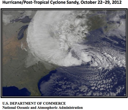
Here’s a report from NOAA. Here’s the preface:
On October 22-29, 2012, Hurricane/Post-Tropical Cyclone Sandy moved from the Caribbean to the U.S. Eastern Seaboard, ultimately making landfall near Brigantine, NJ, around 7:30 p.m. on October 29. The storm resulted in an enormous impact to life and property in both the Caribbean and continental United States. The National Hurricane Center’s Tropical Cyclone Report estimated the death count from Hurricane Sandy at 147 direct deaths. Sandy damaged or destroyed at least 650,000 houses and left approximately 8.5 million customers without power during the storm and its aftermath. The effects of Sandy extended as far west as Wisconsin. This late season storm also generated blizzard conditions in western North Carolina and West Virginia, resulting in snowfall totals as high as 3 feet.
Storm surge created some of the most devastating impacts, including flooding in New York City’s subway tunnels, water overtopping runways at La Guardia (Figure 1) and Kennedy airports, and damage to the New Jersey Transit System estimated at approximately $400 million.
In light of the Sandy’s significance, the National Oceanic and Atmospheric Administration (NOAA) formed a Service Assessment Team to document and evaluate the agency’s performance and effectiveness. The Team focused on three key points: first, the National Weather Service’s forecast, watch, and warning products, including its underlying philosophies and policies and its dissemination/communication tools. Second, the Team reviewed the NWS web presence as a tool for communicating with the public. Finally, the Team looked at NWS’s production and issuance of storm-surge related products.
NOAA will use the findings and recommendations in this assessment to increase awareness of critical needs during future extreme weather events and improve products and services to further protect life and property. Given the relationship of this assessment to the agency’s broader portfolio, NOAA will also improve integration and collaboration across mission lines to ensure ongoing responsiveness to partner needs in light of Sandy’s impacts.
Thanks to CBSNews.com (Danielle Elliot) for the heads up:
Dr. Radley Horton, a climate scientist at Columbia University and NASA’s Goddard Institute for Space Studies, says three environmental factors — sea level rise, warming upper ocean temperatures, and arctic sea ice melt — contributed to the level of damage .
“Sea levels were higher when Sandy hit then they were say 100 years ago,” Horton explained to CBSNews.com. “As a result of that, the damage, the water piling up, was higher than it would’ve been before we had that sea level rise.”
In understanding why sea levels are rising, Horton says we need look no further than greenhouse gas emissions.
“We’ve got about 40 percent more carbon dioxide in the atmosphere now than we did at the start of the Industrial Revolution. That’s almost entirely due to human activities, the burning of fossil fuels, land use changes, cutting of forests,” he said.
“As a result, we’ve got more of these heat-trapping gases in the atmosphere. Some of that heat warms the atmosphere, some of it goes down into the ocean, and a warming liquid expands. Additionally, some of that ice that was trapped on land before is starting to melt, making its way into the water where it can cause sea level rise.”
Climate models predict that sea level will rise an additional two to three feet in the New York area over the next century. “That alone could lead to three times as frequent coastal flooding events for New York even if storms like Sandy don’t change at all,” Horton said.
Warmer upper ocean temperatures, which have also come as a result of greenhouse gas emissions, are providing more fuel for the hurricanes. So, while the region might see the same types of storms, they may be more frequent and more powerful than before.
Rising temperatures in the Arctic are also playing a role, according to a preliminary study that Horton is currently completing.
“The idea is that as we lose sea ice in the Arctic, the Arctic warms dramatically… We now have a lower temperature gradient between the warm tropics and those now-warmer polar regions,” he explained. “That changes the jet streams, which changes the steering patterns that affect storms like Sandy.”
If the jet stream continues to weaken, storms will be more likely to follow a track similar to Sandy’s, because the jet stream won’t be strong enough to push them east over the Atlantic as it has in the past.
