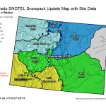
Statewide snowpack map March 27, 2014 via the NRCS
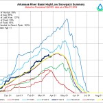
Arkansas Basin High/Low graph March 27, 2014 via the NRCS
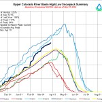
Upper Colorado River Basin High/Low graph March 27, 2014 via the NRCS
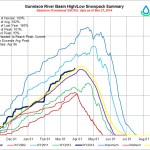
Gunnison Basin High/Low graph March 27, 2014 via the NRCS
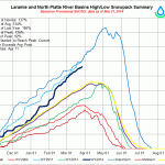
Laramie and North Platte Basin High/Low graph March 27, 2014 via the NRCS
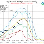
Upper Rio Grande River Basin High/Low graph March 27, 2014 via the NRCS
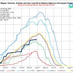
San Miguel/Dolores/Animas/San Juan Basin High/Low graph March 27, 2014 via the NRCS
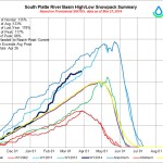
South Platte River Basin High/Low graph March 27, 2014 via the NRCS
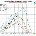
Yampa/White/Green River Basin High/Low graph March 27, 2014 via the NRCS
Click on a thumbnail graphic to view the snowpack for your favorite basin and the gallery of graphics from the NRCS. (Thanks Mage.)
Like this:
Like Loading...