Snowpack news: The haves and the have nots, northern vs. southwestern basins

Click on a thumbnail graphic to view the snowpack for your favorite basin and the gallery of graphics from the NRCS. (Thanks Mage.)

US Rep. Scott Tipton is watching the new EPA proposed rules closely

A look back at old-school irrigation efficiency — Greg Trainor #COWaterPlan

Flood irrigation -- photo via the CSU Water Center
Flood irrigation — photo via the CSU Water Center

From the Glenwood Springs Post Independent (Greg Trainor):

In the early 1980s, I worked for the Atlantic Richfield Company (ARCO) on the Colony Oil Shale Venture at Parachute, Colo. I was a staff member in ARCO’s Community Development Group that was working on the development plans for the Battlement Mesa New Town. The New Town was designed to house the thousands of oil shale workers that were expected to move to western Colorado for oil-shale jobs.

ARCO had been in the oil-shale business for some time and had purchased property on Battlement Mesa 30 years earlier in anticipation of oil-shale development. Upon purchase of these properties, ARCO leased the lands back to the original owners, allowing them to continue farming and using the water rights attached to the ranch lands. This continuation of use of the agricultural water rights ensured that the rights would not be abandoned, and the water would be available when the oil shale industry had need for it.

One of my responsibilities with ARCO was to manage these leased ranch lands, working with previous owners, tracking water use, and ensuring a communication link between the land owner (ARCO) and the ranch lessees.

One of ARCO’s lessees was a man named Dan Duplice, a sheep herder and farmer. Dan lived on Battlement Mesa and owned a band of sheep that traveled each summer from Battlement Mesa, across the Colorado River, and up the steep, hair-raising trails that connected the Colorado River valley floor with the thousand-foot-thick horizontal bands of the oil shale cliffs. At the top of these cliffs were the spruce-fir zones and open, grassed parks of the Roan Plateau.

Dan had farm lands on Battlement Mesa that were fed by a small ditch that crisscrossed the lower elevations of the mountains that rose above Dan’s farm. Known as ā€œPeteā€ and ā€œBill,ā€ these peaks held snow at high elevations as well as on their lower slopes. It was the ā€œlow waterā€ that Dan, and now ARCO, had rights to. With an early and short run-off of this ā€œlow water,ā€ Dan had to take early advantage of the flow when it appeared.

On my travels of Battlement Mesa, I would find Dan standing at the head of his alfalfa fields where the ditch emptied into his laterals. He would carefully bring the water to his creases, allowing only enough water down the crease to wet it down to the end of the field. Then he would move the water from one set of creases over to a new set and repeat the process. Dan would stand there with his shovel, husbanding the flow down the field, making sure that it got the water it needed and that no water left the bottom of his fields.

Having spent most of my adult life in western Colorado, I was more used to standard ā€œflood irrigation,ā€ where irrigators would open up their laterals and flood their fields with all the water the creases would carry. Then, leaving their sets to return later in the day, irrigators would allow their water to flow down across the field and out the end of the field as return flow, usually into the small drainages that would carry the return water to the Colorado River.

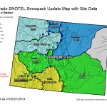
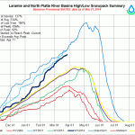
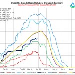
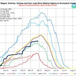
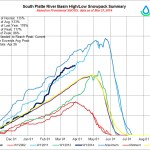
Today I participate in the Colorado Basin Roundtable, one of nine roundtables across Colorado working on development of the Colorado Water Plan, which the governor says is supposed to point the way forward to meeting the needs of growing cities and towns while also preserving agriculture, the environment and recreational opportunities. It’s a tall order.

Agricultural water efficiency improvements are often suggested as a tool to address shortages and to leave more water in streams for environmental and recreational purposes. As I participate in the discussions, I think of Dan Duplice and my observations of him 34 years ago.

Dan Duplice invested a significant amount of time to the special care of the flow and management of the available water. Despite the small amount of water carried by his ditch, the result was the production of an incredible amount of tall, thick alfalfa before this ditch water trickled out.

In times of drought and increased competition for water, the kind of careful management of water practiced by Dan Duplice may have to become more widespread. His experience showed that good yields can still be had when water is tight — but it’s not easy. He spent a lot of time in those fields with a shovel.

More Colorado Water Plan coverage here.

Drought news: Dryness increases in parts of the southwestern US

US Drought Monitor March 25, 2014

Click here to go to the US Drought Monitor website for the dreary outlook for much of the southwestern US. Here’s an excerpt:

The Plains

As with the rest of the northern tier, the High Plains experienced below-normal temperatures and light snowfall during the past week. In South Dakota, short-term precipitation deficits led to expansion of Abnormally Dry (D0) in the southeastern part of the state. Further south, extreme eastern Oklahoma received about one inch of precipitation in a few isolated pockets. In western portions of Oklahoma, continued short-term precipitation deficits, low humidity, and windy conditions continued to dry top soils leading to the expansion of areas of Severe Drought (D2), Extreme Drought (D3), and Exceptional Drought (D4). In Kansas, short- term dryness led to expansion of Moderate Drought (D1) in the central portion…

The West

During the past week, several storm systems pushed across the Pacific Northwest delivering snowfall to the North Cascades and northern Rockies as well as portions of northern Colorado while dry conditions prevailed across the rest of the West. Temperatures across the Southwest were above normal and in the Sierra Nevada warm conditions enhanced melting of the already shallow snowpack. According to the Natural Resource Conservation Service SNOTEL network (for the current Water Year starting October 1st), river basin average precipitation was below normal across the mountains of Oregon, northern Nevada, Arizona, and New Mexico while above average precipitation was observed across the central and northern Rockies. On the map, short-term precipitation deficits led to expansion of Severe Drought (D2) in southeastern California as well as expansion of a small area of Exceptional Drought (D4) along the coast in Santa Barbara and Ventura Counties. In northwestern Nevada, severely reduced water allocations for agriculture and long-term precipitation deficits led to expansion of Exceptional Drought (D4). According to NCDC Climatological Rankings, Nevada CD 1 (Northwestern) ranked 2nd driest on record for the 24-month period. In Utah and southwestern Colorado, dry soils and below normal streamflows led to expansion of Moderate Drought (D1). In southeastern Colorado, strong winds continued to degrade topsoil conditions and affect wheat crops leading to expansion of Severe Drought (D2) in Baca County. In New Mexico, short-term precipitation deficits and dry soil conditions led to expansion of Extreme Drought (D3) in south-central New Mexico and expansion of Moderate Drought (D1) in southeastern New Mexico…

<strong>Looking Ahead

The NWS HPC 7-Day Quantitative Precipitation Forecast (QPF) calls for moderate-to-heavy precipitation across northern California, the Pacific Northwest, and the Northern Rockies of Idaho and Wyoming. Across the South, precipitation accumulations of one-to-two inches are forecasted while greater accumulations (two-to-four inches) are expected across portions of the Northeast. The 6-10 day outlooks call for a high probability of above-normal temperatures across most of the West and Southern Plains while the Northern Plains, Upper Midwest, and Eastern Seaboard will be below-normal. A high probability of above-normal precipitation is forecasted across most of the northern tier of the Lower 48 while the Southwest is expected to have below-normal precipitation.

Evolution illustrated

Weekly Climate, Water and Drought Assessment of the Upper #ColoradoRiver Basin

Upper Colorado River Basin March 1 - 23 month to date precipitation via the Colorado Climate Center
Upper Colorado River Basin March 1 – 23 month to date precipitation via the Colorado Climate Center

Click here to read the current assessment. Click here to go to the NIDIS website hosted by the Colorado Climate Center.

Playing in the newly arrived #ColoradoRiver at San Luis Rio Colorado