From The Colorado Springs Gazette:
In Colorado, water is as precious as a rare diamond, though much easier to get your hands on – at least for now.
The future may be another matter.
Frequent droughts, an increasing population and greater demand for water have elected officials, conservationists and the business community worried about the future of Colorado’s water supply.
The specter of future shortages prompted Gov. John Hickenlooper to issue an executive order last year to establish a statewide water plan, said Wayne Vanderschuere, general manager for water resources for Colorado Springs Utilities. The initiative involves people from various statewide water basins coming together to discuss how best to conserve, share, find, develop and expand the existing water supply, Vanderschuere said.
Against this backdrop, business and conservation groups are holding statewide meetings to hear what corporate executives and small-business owners have to say on the importance of water to their ventures, and to get their ideas on conservation and other steps that could be added to the governor’s plan.
“A reliable and sustainable water supply is critical for long-term economic viability,” said Joe Raso, president and chief executive officer of the Colorado Springs Regional Business Alliance, which is hosting an April 2 briefing for the business community on the governor’s water plan.
It’s not just having enough water for existing businesses, Raso said. Even a perception that the city and state might be struggling to maintain its water supply could crush business growth, he said. Water usage is a primary cost of business for major industries and accounts for at least a portion of all small business costs. The cost to provide sufficient water in the future could increase utility prices beyond the average business owner’s ability to pay, Raso said. Those costs also encourage larger businesses to move or locate elsewhere, he said.
“If you have a company that decides the state and Colorado Springs is too expensive for their processes, or if they are worried about the impact of their water usage on the community, then they will locate elsewhere,” he said.
Less water flowing in
Four things must happen with the state’s water supply to keep the commodity from becoming a burden to businesses, said Bryan Blakely, president of Accelerate Colorado, one of two organizations making the April 2 presentation in Colorado Springs.
“We are looking for efficiency, predictability, reliability and cost control,” said Blakely, whose organization pairs state businesses and local governments to work with Congress on issues related to the state’s economic development.
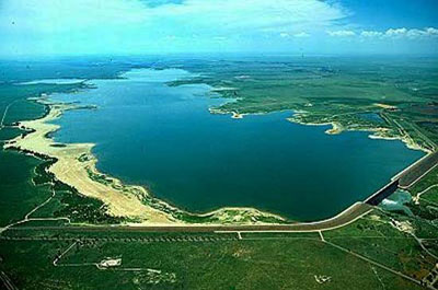
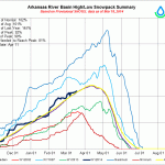
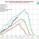
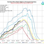
He said one of the primary ways the state could increase available water is construct additional systems that would capture and store more of the state’s snow and rain runoff. Capturing and storing more in years of abundant snow and rainfall would provide additional supplies in dry years, Blakely said.
“There is a lot of water flowing out of the state of Colorado that we have the rights to,” he said, “but we don’t have anywhere to store it.”
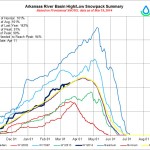
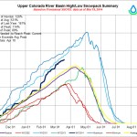
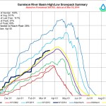
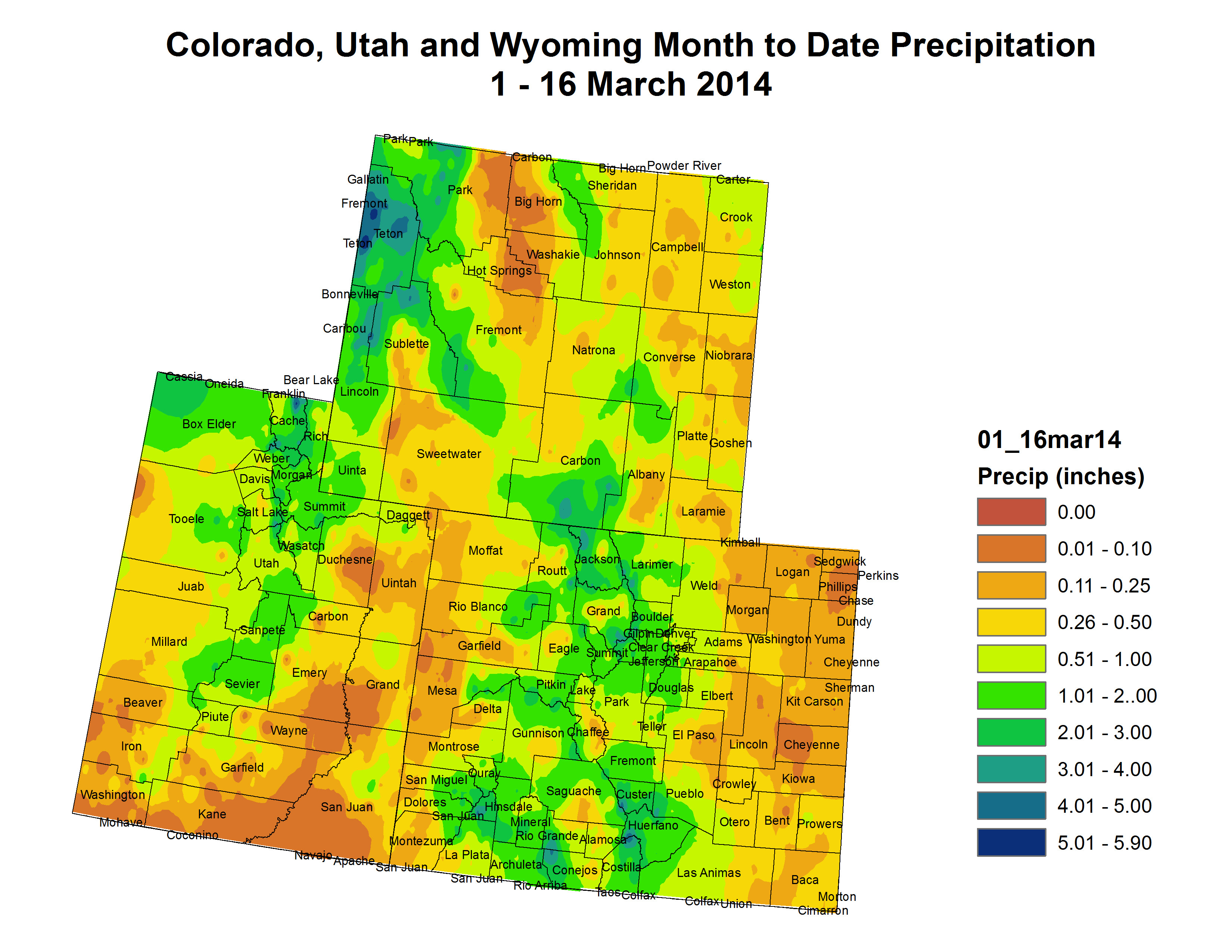
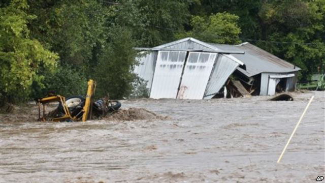
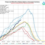
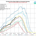
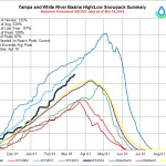
There is also a lot less water flowing into the state.
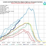
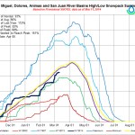
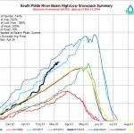
From 2001 through 2010, the Colorado River flow averaged 16 percent below the 20th century average, according to Environmental Entrepreneurs, “a national community of business leaders who promote sound environmental policy that builds economic prosperity,” according to its website, e2.org.
The group’s research, “Colorado Water Supply and Climate Change: A Business Perspective,” states that “from 1999 through 2005, Lake Powell, the Colorado River reservoir designed to ensure delivery of water to the lower basin, fell from 99 percent of capacity to 33 percent, a sharper decline than thought possible.”
Cooperation is key
Solving the state’s water problems will involve the implementation of several ideas. E2 has said the governor’s plan must include a goal of reducing per capita urban water use by 25 percent by 2025 and by 50 percent by 2050. It also wants the state to “require all water providers to adopt water rates that create incentives for water conservation” and expand water reuse programs.
Vanderschuere said finding a solution will require cooperation between governments, organizations and people.
And there will be challenges. Agricultural enterprises, including farms and ranches, account for about 86 percent of the state’s annual water usage annually. But Colorado law is written so that it’s unlikely the state or any municipality could reduce the amount of water used by agriculture, even in lean years.
Still, Vanderschuere said those in agriculture have been the most willing to help when it comes to droughts.
“At least once a week I get someone calling me trying to lease us their water rights,” he said. “And we have had leases from ag in the past and will do so in the future.”
If that’s the case, why worry?
“The problem is getting the water from the farms to the urban area,” Vanderschuere said.
Pumping, transporting, treating and distributing water from farms sometimes can be too costly for the amount of water received. Vanderschuere believes the state could develop ways to capture Colorado’s remaining allotment off the Colorado River, which also supplies water to Arizona, California and Nevada. He said Colorado has “a very specific allocation under the law of the river,” but right now the state is not using its full legal portion.
“What is important is recognizing on the statewide perspective that there is an increasing gap in the water supply and water demand,” he said, “and with the state population expected to double by 2050, that is not very far off in water time.”
While the population growth could be good for business in terms of having more customers, any real or perceived water shortage could stymie future business growth. Hence, the series of roundtables in each of Colorado’s eight major water basins to work on the governor’s initiative.
Vanderschuere said the statewide water meetings are important because it takes decades to create solutions to water problems. He used the term “water time” to describe the time it takes to plan, design, permit, construct and start the flow of water through a new project. For example, he said the Southern Delivery System will be completed in 2016, but the project was envisioned in the 1980s, planned in 1990s and permitted around 2010.
Contact Ned Hunter: 636-0275.
—
DETAILS
The Colorado Springs Regional Business Alliance is hosting Accelerate Colorado and the Colorado Competitive Council for a business briefing on Gov. Hickenlooper’s statewide water plan, “and to help finalize a new set of statewide business community water policy principles that address the business and economic development needs of Colorado,” according to the alliance’s website,
WHEN: 8-9:30 a.m. April 2
WHERE: Antlers Hilton, 4 S. Cascade Avenue
COST: Free
ETC: Register online at http://bit.ly/1dnvZi6. For more information, contact Shawn Dahlberg at 884-2832.
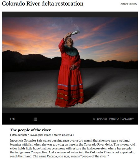
More Colorado Water Plan coverage here.