Click here to read the review/preview. Here’s an excerpt:
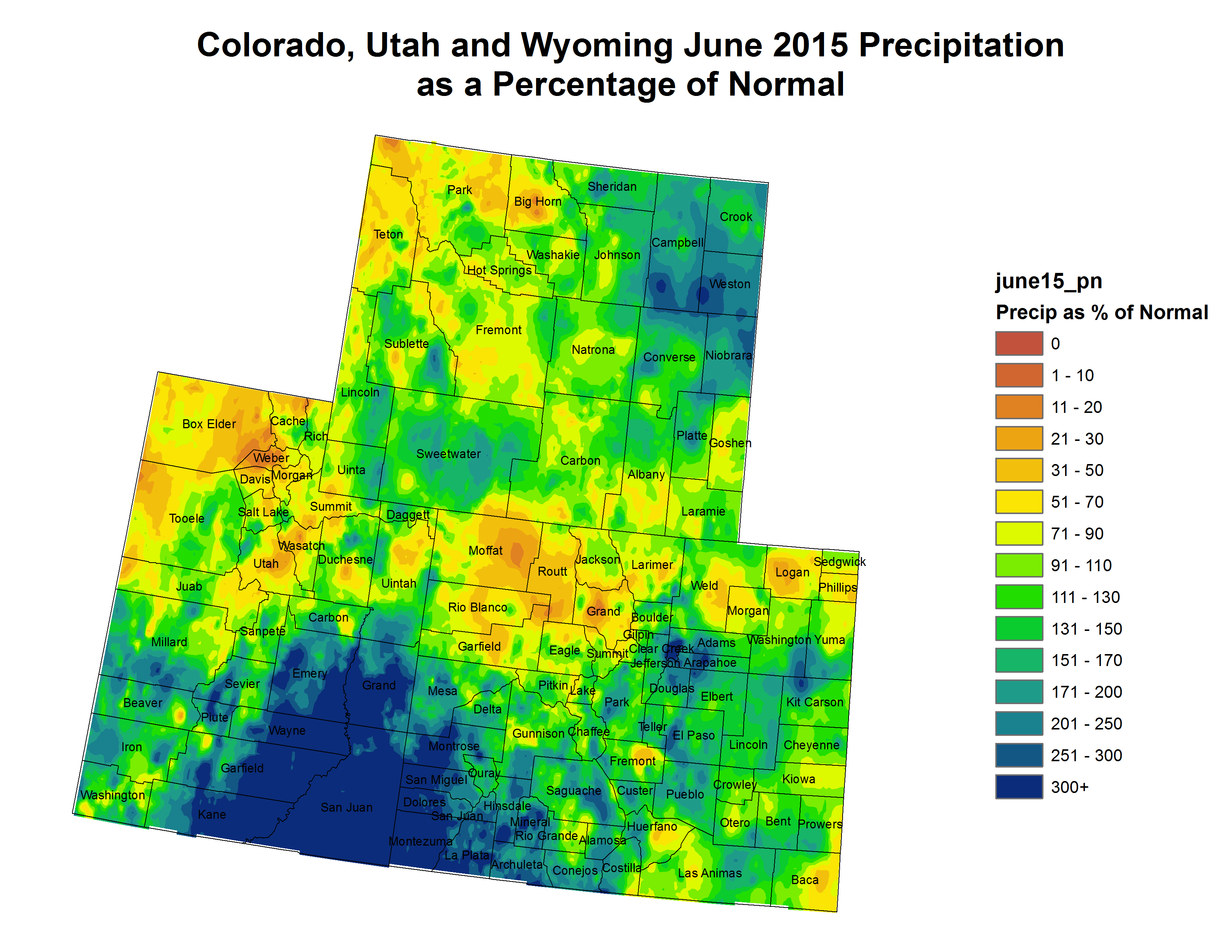
June of 2015 was generally warm and wet across most of south central and southeast Colorado, save for portions of the southeast Plains which saw at or below normal precipitation for the month as a whole. The following graphics depict preliminary departures from normal for both temperature and precipitation over the past month across the state.
The preliminary average temperature over the past month of June in Colorado Springs was 68.5 degrees. This is 3.4 degrees above normal and makes June of 2015 the 16th warmest June on record in Colorado Springs. This, however, remains well below the average temperature of 73.3 degrees recorded in June of 2012. Colorado Springs recorded 5.72 inches of precipitation through out the month of June. This is 3.33 inches above normal and makes June of 2015 the 4th wettest June on record in Colorado Springs. This, however, remains well below the 8.00 inches of precipitation recorded in June of 1965. Of note, Colorado Springs set a new record for daily maximum precipitation of 3.16 inches on June 15th. Hail was recorded at the Colorado Springs Airport on June 5th, June 11th, and June 28th.
The preliminary average temperature over the past month of June in Pueblo was 72.8 degrees, which is 2.8 degrees above normal. This, however, remains well below the average temperature of 77.0 degrees recorded in June of 2012. Pueblo recorded 1.22 inches of precipitation through out the month of June, which is 0.14 inches below normal.
The preliminary average temperature over the past month of June in Alamosa was 63.0 degrees. This is 3.5 degrees above normal and makes June of 2015 the 3rd warmest June on record in Alamosa. This, however, remains below the average temperature of 64.5 degrees recorded in June of 2012. Alamosa recorded 1.19 inches of precipitation through out the month of June. This is 0.70 inches above below normal and makes June of 2015 the 10th wettest on record in Alamosa. This, however, remains well below the 2.58 recorded in June of 1969.
As a state senator in the mid-1960s, a bipartisan group of us in the legislature wanted to provide opportunity to a new kind of student — those who put in long hours working and trying to make a better life for themselves, while longing for an opportunity to go to college. We sought to provide a place where they could get a quality education at an affordable price, in an accessible location. These were people from myriad backgrounds — middle income and poor families, minorities, women, married students and returning veterans — all who needed a second chance.
One of the hardest political battles of my career was the bill to create Metropolitan State College (now University), alongside Rep. Palmer Burch, Rep. Allan Dines, Rep. Mark Hogan, Rep. Frank Kemp, Sen. Joe Shoemaker and others. In a General Assembly dominated by rural interests, a downtown college was a hard sell. It was a hard-fought, seven-year fight to establish Colorado’s first state-funded institution in the metro Denver area.
On an early fall day in 1965, students began lining up in front of the Forum Building at 14th and Cherokee streets, intent on registering for classes at a new kind of school, one where they would be accepted for who they were and could grow into who they were meant to become. The school’s new leaders were expecting around 500 students that day, but by midnight had signed up 1,189.
Fifty years later, MSU Denver remains true to its roots. Founded on the idea that it serve as a modified open-enrollment institution that accepts students from all walks of life, it focuses on the hope of a brighter future, not on the socioeconomic factors that might prevent pursuit of a higher education…
The university has 2,200 faculty and staff supporting more than 21,000 students. MSU Denver has grown, but retains the same spirit, the same dedication and the same noble purpose that moves all who are a part of it.
As Colorado’s urban university, MSU Denver collaborates with the community on innovative programs that fulfill its need for an educated workforce and our students’ need to prepare for interesting and rewarding careers. The university was ranked 23rd among regional colleges in the West, and fifth among public institutions for 2014.
MSU Denver’s success at transforming lives, and the citizens of Denver, lies in its strong ties to the community and to its business leaders and public officials who always have been the heart and soul behind the success of the university. Its impact on Colorado can be seen as its students graduate and enter the workforce as professionals well prepared for careers with giant industries like aerospace, tourism, health care and manufacturing. MSU Denver now has 80,000 alumni, many of whom have reached pinnacles of success that might not have been imagined 50 years ago: brigadier generals, high level administrators in executive branch organizations, policymakers, pilots, mayors, engineers and health care professionals.
More than any other state college or university, MSU Denver mirrors Colorado’s population, with ethnic minorities representing 34 percent of the student body, 21 percent Latino. Furthermore, MSU Denver is already well known for educating Colorado students for Colorado’s workforce. More than 96 percent of the university’s students are Colorado residents, and 75 percent of MSU Denver graduates stay in the state.
As MSU Denver continues to collaborate with leading businesses along the Front Range, it has become well known for preparing the next generation of “scrappy” students to achieve success that before may have eluded them.
On the eve of MSU Denver’s 50th anniversary, I am proud to be a founding father of this fine university rooted in the Denver community and committed to giving both the traditional and nontraditional student ample opportunity to succeed — as any father would be.
“We started in May with a rain cycle,” said Dick Wolfe, Colorado’s state engineer. “Things really turned around.”
He said conditions during March were not as snowpacked as is typical for the Centennial State. “We were way behind,” Wolfe explained. “But May was a huge turnaround in what we saw.”
According to Wolfe, the National Weather Service has deemed the month of May the wettest month, setting a national record “which is pretty impressive.” He added that this is the first turnaround of significance to have occurred during more than a decade of drought.
“Reservoirs are full or nearly full,” he commented. “We’ve got good reservoir storage.”
Coloradans saw an extended winter season in 2015 with cooler-than-normal temperatures moving into May. Monsoonal flows, typically seen during the summer months, took hold early and resulted in heavier-than-normal springtime rains. News accounts were rife with stories about flooding or potential for flooding.
The flirtation with summer began in early June as temperatures climbed and rains diminished. But, as Wolfe noted, weather forecasters have been keeping their eyes to the skies and are predicting that rainy patterns will return in July and continue into September.
“July through September is supposed to be above-average precipitation,” Wolfe commented. “Colorado is right in the bull’s-eye for rainfall predictions.”
Although the majority of Colorado falls outside the drought profile at the current time, he said areas from the western part of Colorado’s San Luis Valley to Gunnison are still dry.
According to Wolfe, the much-needed precipitation and favorable water storage condition mean that agricultural producers will have more water available for irrigation in 2015. “With good runoff and water supply, there aren’t the calls on the river that been restricted in years past,” he explained.
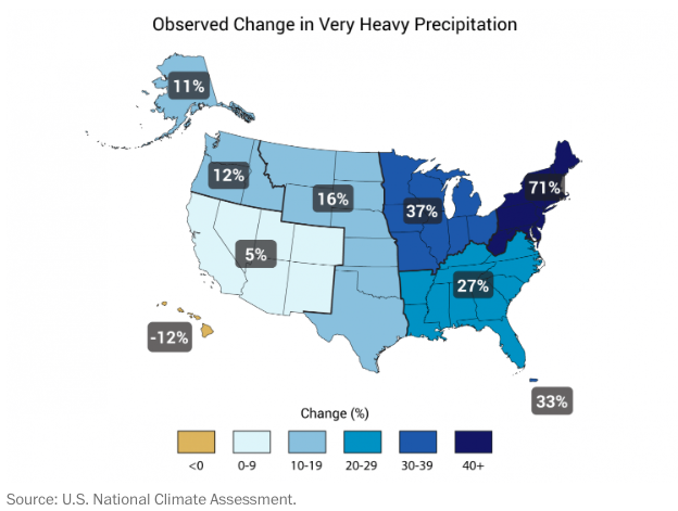
Graphic via the National Climate Assessment via The Washington Post FromThe Washington Post (Chris Mooney):
Last week, some people got really mad at Bill Nye the Science Guy. How come? Because he had the gall to say this on Twitter:
“Billion$$ in damage in Texas & Oklahoma. Still no weather-caster may utter the phrase Climate Change.”
Nye’s comments, and the reaction to them, raise a perennial issue: How do we accurately parse the relationship between climate change and extreme weather events, as they occur in real time?
It’s a particularly pressing question of late, following not only catastrophic floods in Texas and Oklahoma, but also a historic heatwave in India that has killed over 2,000 people so far, and President Obama’s recent trip to the National Hurricane Center in Miami, where he explicitly invoked the idea that global warming will make these storms worse (which also drew criticism).
As the Nye case indicates, there is still a lot of pushback whenever anyone dares to link climate change to extreme weather events. But we don’t have to be afraid to talk about this relationship. We merely have to be scrupulously accurate in doing so, and let scientists lead the way.
Take the floods. One exemplary voice here has been Texas Tech climate researcher (and evangelical Christian) Katharine Hayhoe, who took to Facebook to explain the science. As Hayhoe noted, climate change doesn’t “cause” individual extreme events, in this case or in others. But “just like steroids make a baseball player stronger, climate change EXACERBATES many of our weather extremes, making many of them, on average, worse than they would have been naturally,” she said.
Thus, Hayhoe treated the link between a changing climate and the floods not as a matter of simple causation, but as a matter of context. She notes that overall, “heavy rainfall and flood risk is increasing,” due to the fact that warming charges the atmosphere with more water vapor, which is then more available to fall in individual precipitation events.[…]
And what about India’s extreme heat? Here again, we must bear in mind that extreme weather events are not directly caused by climate change. Indeed, weather extremes can occur — and weather records can break — due solely to natural climate variability.
Nonetheless, and as with past major heat extremes, such as Australia’s 2012-2013 “angry summer,” the odds of an event like this one occurring may have shifted. Indeed, meteorologist Jeff Masters of the Weather Underground has directly stated that the heat wave “was made much more probable by the fact that Earth is experiencing its hottest temperatures on record.”
Colorado Springs Mayor John Suthers is asking for $19 million a year to mitigate the flow of Fountain Creek as it goes downstream. He told 11 News $8 million would come from bonds, $3 million from Springs Utilities and $3 million from the city’s general fund. That still leave $5 million for the plan to work, meaning there could be budget cuts…
“We’re prepared to make budget cuts and sacrifices as necessary to resolve this issue. We’ve got to get this issue behind us and move on with relations between Pueblo and Colorado Springs,” said Suthers.
He told 11 News cutting city employee salaries could be how they make up the rest of the money needed for the plan, although nothing is set in stone yet and there is a lot of work to be done before the plan is finalized.
Colorado Springs sent something other than rushing water, logs and mud Pueblo’s way Monday.
Springs Mayor John Suthers and City Council President Merv Bennett met with the Pueblo City Council at its work session to backfill trust that has been eroding when it comes to Fountain Creek.
“We are going to fund our stormwater requirements,” Bennett said. “We will resolve this. We owe it to all the people in the Arkansas Valley.”
Suthers said it was not fair to Pueblo and other communities downstream that Colorado Springs City Council yanked funding from its stormwater utility in 2010 on a split decision after a murky 2009 vote. That meant funding of about $16 million annually washed away.
“At one time Colorado Springs was committed to funding stormwater and then it went away,” Suthers said. “That was flat unfair to Pueblo.”
Colorado Springs voters last year again rejected a regional stormwater fee and Suthers doesn’t want to keep going back to the same well. Instead, he and the current council want to put a road tax to a vote and find the money for flood control in the Colorado Springs general fund.
“Selling roads to the voters is easier than stormwater,” Suthers said.
The plan is to shift funding to provide $19 million a year for stormwater, which Suthers said could strain other departments, but is necessary for Springs to uphold its commitments.
Pueblo Councilman Bob Schilling called the presentation “a breath of fresh air,” but reminded Suthers and Bennett that Colorado Springs also has a $50 million commitment to fund flood control on Fountain Creek when Southern Delivery System goes online early next year.
That money will be controlled by the Fountain Creek Watershed Flood Control and Greenway District, which has both El Paso and Pueblo counties members.
“The most important thing is that the $50 million cannot benefit Colorado Springs, and don’t split hairs,” said Schilling, the only council member who was serving in 2004 when intergovernmental agreements were signed to protect Arkansas River flows through Pueblo. “I hope you’re real serious and have a way to follow through.”
Bennett and Suthers gave assurances that Colorado Springs plans to incorporate the needs of downstream communities, including Pueblo County and the Lower Arkansas Valley Water Conservancy District, into planning, hinting that future agreements are in the works.
“This is an issue that needs to be dealt with, that needs to be put behind us,” Suthers said.
Pueblo Councilman Chris Nicoll said Springs appears to be more concerned with containing the flows off the Waldo Canyon burn scar than living up to past commitments on Fountain Creek.
“The water from the burn scar doesn’t stop at Colorado Springs,” Bennett said, but added the city must address downstream concerns. “We’ve been investing $20 million a year, and a lot of that is from grants. These dollars are not grant money, but coming out of our general fund.”
Mayor John Suthers presented a plan to fund a permanent storm water enterprise. He says with this plan he is committed to the people of Pueblo and solving the flood problems.
A shake of the hand. This is how City Council President Steve Nawrocki ended tonight’s presentation from Colorado Springs Major John Suthers.
“We have an obligation to the folks in Pueblo to do the best job we can to mitigate some of those impacts caused by Fountain Creek on Pueblo,” Suthers said…
Mayor Suthers presented an idea to Pueblo City Council that would use $19 million a year of Colorado Springs city revenue to mitigate the devastating flow of Fountain Creek into Pueblo.
“We’re prepared to make budget cuts and sacrifices that’s necessary to resolve this issue. We’ve got to get this issue behind us and move on,” he said.
News5 has been tracking much of the Fountain Creek flood damage as beds along this creek have been deteriorating for the past several weeks. And Suthers knows this problem needs immediate attention.
“That’s just part of being responsible and being a good neighbor,” Suthers said.
Pueblo City Councilman Bob Schilling asked Suthers for reassurance that Colorado Springs is on board.
“You’re going to have to stand tall and get your people to care enough about Pueblo to tax themselves on it. And that’s going to be a real project,” Schilling said.
But Schilling sees this as a step in the right direction.
“I truly believe that you all are, hopefully, what I see as a breath of fresh air as far as commitment,” he said.
This is far from a done deal. Suthers must also approach Pueblo County Commissions in hopes of avoiding legal action.
Moving forward, they must decide how to hold Colorado Springs accountable if the city doesn’t come up with the annual minimum payment to Pueblo and, how much input Pueblo will have on these mitigation efforts.
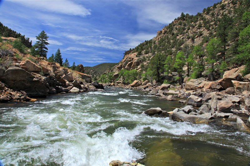
We had come to the canyon that the Yampa carved through ancient Weber sandstone on a raft trip, to talk about the future of wild rivers, and rivers in general. Advocacy groups Friends of the Yampa and American Rivers decided that the best way to talk about water issues was on the water. So they pulled together 20 people who have been making decisions about water in Colorado, and in the West, for the past 30 years—the head of Denver Water, former Deputy Secretaries of the Interior, ranchers, power plant managers and environmentalists—and a few journalists like myself. They tempted them with the idea of running an untapped river, and then stuck everyone in boats for five days so they had to talk to each other.
The Yampa flows from the high country near Routt National Forest, past power plants and ranchlands, into Dinosaur National Monument where it joins the Green River at Echo Park. It hits the main stem of the Colorado just over the border in Utah. Even though it’s not dammed anywhere, it’s used by almost all the major groups who depend on river flows: farms, fish, cities, industry, recreation and power. The coal-fired Craig Power Plant is its major consumptive user. Endangered fish like the Colorado pikeminnow depend on its flow. Along the way it irrigates pasture lands and provides flows for kayakers. And, if it continues to run free—hence the flow-dependent bathtub ring—it can be a model for fish habitat and smart agricultural use…
On the river, as we floated through the folded geology of the canyon and stopped to scout rapids, we talked about those questions. At night, people pulled up chairs around the fire, cracked beers and tried to explain their priorities. We talked about risk management and sharing the burden of drought. The most heated topic was transmountain diversions of water across the Continental Divide, and how to avoid them.
The Yampa, and with it the state of Colorado, is a microcosm of river management. Colorado has to send almost half of the water that falls in the state downstream. To complicate things, the state’s water law is legally layered and hard to change. This spring, a bill that would allow Colorado residents to collect rainwater failed to pass, because it was argued that it could injure downstream water rights.
“It’s just like balancing a checkbook,” says Eric Kuhn, the general manager of the Colorado River Water Conservation District. “Based on the last 16 years, nature has provided a flow of about 13 million acre feet of water at Lee’s Ferry [just below Glen Canyon Dam], and our estimate is that we’re using about 15 million. Since then, we’ve overused the system by 30 to 32 million acre feet, which we know because we’ve drawn down storage by that amount. We started with 50 million in the bank, now we have about 18. The system is heading for zero.”[…]
Water rights are also based on a use-it-or-lose-it principle of beneficial use. In theory, or maybe in the 1920s, that sounds good, because it implies that if you’re using a lot you must need a lot. But now it means that senior rights holders—corporations, irrigation districts, water departments and others with earlier and higher priority rights that get their share of water first—are unlikely to use less water than they’re allotted, for fear they’ll never get it back. It makes conservation unappealing, because by using less, you could be selling your security blanket down the river.
“Everybody is trying to pressure dreams from the past,” says Jay Gallagher, from the Colorado Water Conservation Board, after the boats were pulled up on the beach one day. “They want security for today and something left over for tomorrow. That’s the root of the emotion around water, the fear of losing it.”
That’s particularly true on the Yampa, which feels like the last of a dying breed. The Colorado itself has been so allocated that it no longer flows to the Pacific, and other western rivers, like the Dolores, in southern Colorado, are considered dead, because only a trickle flows past the dam. The Yampa is the only one that has remained untouched despite proposals to siphon off or dam up its flow.
Conservation across all facets of the water system, from farming to lawn watering, could stanch the bleeding, but it’s tricky to ask people who have a legal right to a certain amount of water to give it up. To change both perspective and use patterns, you have to make the greater good also good for the individual. Kuhn says that basically comes down to money—you have to make it financially smart for water users to conserve…
Kuhn is trying to outline the clearest ways to make conservation financially appealing. There is talk of setting up a water market, where willing sellers and buyers can trade water rights. “Those plans are moving at a snail’s pace, but the conversations are happening,” he says. People on the trip are also working together on smaller, creative projects. Blakeslee is fallowing parts of the ranch he manages to try to conserve, while American Rivers is working with ranchers to create manmade riffles—small rapids where fish can find food—on streams to build trout habitats without diverting any water.
On the Yampa, despite the disparate intentions, there was more teamwork than infighting. “Overall the average amount of water we recieve each year is still below our needs,” Kuhn says. “What we need to figure out how to do is live within our means.”
One evening on the banks of the river, Matt Rice, the director of American Rivers’ Colorado River Basin Program, brought out a bottle of beer he’d been saving. “It’s called ‘Collaboration Not Litigation,’” he said. “And I think we should all have some.”
By 2050, Colorado’s population is expected to jump from 4.5 million to approximately six to eight million people. Meanwhile, Colorado’s water supply isn’t growing.
“Everybody woke up to the fact that if we’re going to grow our state, we have to take a serious look at water supply,” said Jim Pokrandt, Chair of the Colorado River Basin Roundtable.
Through a series of roundtable meetings in each of Colorado’s nine water basins, officials are attempting to formulate a plan that meets the needs of several entities – Municipal, environmental, recreational, and agricultural.
Historically, when Colorado’s water supply has fallen short, the state will buy the water rights from local farmers to fill the void. The problem is this “Buy and Dry” strategy has devastated Eastern Plains communities in the past. On top of that, global warming is requiring farmers to use more water than they have ever had to use before.
“Under hotter temperatures, all plants take more water,” said Holm.
Ultimately, water leaders want to avoid this strategy.
“It doesn’t paint a pretty picture for Colorado, whether it’s fruit security or other things agriculture provides like wildlife habitat and environmental benefits,” said Carlyle Currier, Colorado River Basin Representative on the Inter-Basin Compact Committee.
Another option being considered is adding even more water to the 500,000 acre feet sent from our side of the state to the Front Range.
Even though most of Colorado’s river water is on the Western Slope, additional diversions would put a lot of stress on the Colorado River Basin, an area that is already obligated to divert water to other western states.
“Our obligation is to let at least 75 million acre feet flow downstream from Lake Powell over each ten year period,” said Holm.
If the Eastern Slope ends up taking more water, it will be tougher for the Colorado River Basin to meet these obligations.
“That water will have to come from somewhere, and if we take more from the river we will have to add more back to the river primarily by drying agriculture,” said Pokrandt.
Even in this hotly-debated topic, the one constant among the majority of Western Slope leaders is the focus on conservation.
“They would like to see the Front Range cities do as much as possible on the conservation and reuse front as they can before they come looking to the West Slope for water,” said Holm.
Other solutions being tossed around range from cloud seeding to proper forest management to reducing city water use.
The public comment period on the first draft of the plan ended at the beginning of May, but the public will have the opportunity to place further comments once the second draft is released on July 15th.
The final Colorado Water Plan will be submitted to the Governor on December 10th.
Click here to to the Land Trust of the Upper Arkansas website to view upcoming events:
<blockquote>Moth Madness program highlights lesser-known Wildlife – July 17
Conserve the land — boogie with The Hazel Miller Band – July 24</blockquote>
Utilities announced the settlement Thursday. It had appealed the jury decision May 7, followed by Walker’s appeal May 14. Under the settlement, both appeals will be dismissed.
The city-owned utilities company also will fence revegetated areas on the ranches to protect them from cattle and will erect berms to reduce erosion across the 5.5-mile easement Walker provided for installation of the Southern Delivery System pipeline.
The rancher and Utilities had agreed that the easement was worth $82,900, and the pipeline was installed there in 2012…
But the SDS easement caused problems, Walker said at trial, with rain eroding the pipeline scar and Utilities introducing soils contaminated with seeds of invasive species. He also said the pipeline jeopardized a $25 million conservation easement he was negotiating with the Nature Conservancy for $1,680 an acre on 15,000 acres.
The settlement says both parties are committed to work together to manage and maintain the right-of-way.
Utilities said the pact gives it “additional certainty” about SDS costs, thus minimizing risk to ratepayers.
“It has always been our intent when working with property owners to use the court process as a last resort,” SDS program director John Fredell said in a news release. “By successfully resolving these issues with Mr. Walker, we can focus on completing the required revegetation on his property and finishing the SDS project on time and under budget.”
From the Colorado Springs Independent (Pam Zubeck):
Colorado Springs Utilities and Pueblo County rancher Gary Walker have come to terms to settle a lawsuit over land needed for the Southern Delivery System water pipeline.
The city-owned utility will pay Walker Ranches $7.1 million, ending litigation that led to a jury award of $4.75 million earlier this year and subsequent appeals filed by both the city and Walker.
A final draft of Colorado’s Water Plan will be released next week, triggering a few more months of activity before reaching its completed form in December.
The plan is moving toward its final version after Gov. John Hickenlooper ordered it in 2013. The first draft was completed last year by the Colorado Water Conservation Board. The state’s nine roundtables also have completed basin implementation plans that will become a part of the completed plan.
The draft of the final plan is scheduled to be released on July 15, with public comments accepted through Sept. 17.
The plan seeks to ease the strain increased urban population will put on the state’s water resources, with particular emphasis on preserving agricultural and the environment. It has been driven by public comments through numerous meetings over the past two years.
“We don’t want to get in the same situation where California is in,” said John Stulp, Hickenlooper’s top water adviser. “We want a plan in place before there is another drought.”
The plan will have more concrete solutions to state water needs than the draft submitted to the governor last year, Stulp said.
There is, for instance, a target for municipal conservation savings — 400,000 acre-feet as a “stretch goal” — along with some steps that could be taken to get there.
“There are no ‘thou shalts’ in it. For one thing, we don’t as a state have that authority. It’s more about education and timing,” Stulp said.
“The municipalities have done a great job since 2002-03, with about 20 percent less use. That’s been done through incentives and education.”
The plan also talks about how future water projects could be financed, again without committing state funds to any project.
“It talks about general concepts, and publicprivate partnerships,” Stulp said. “It gives wider latitude to the CWCB for drinking water projects and to the Colorado Water Power and Development Authority for other types of projects.”
The two agencies are the major public lenders for water projects, but their roles have become stratified.
“We want to work more cohesively so folks won’t have to be shopping for loans,” Stulp said.
The plan also will talk about removing state and federal bureaucratic hurdles that have slowed down the construction of water projects.
“There will be more emphasis on multipurpose projects, and groups working with each other rather than trying to gain leverage,” Stulp said.
“We’re hoping we can get state agencies involved early on and address concerns earlier in the process.”
There are also suggestions for policy changes and future legislation, based on the activities of the past 10 years among roundtables and the state’s Interbasin Compact Committee. Among those are demonstration projects, such as the Arkansas Valley Super Ditch, which seek to create ways to share agricultural and municipal water. The legislative interim water resources review committee, co-chaired by Rep. Ed Vigil, D-Fort Garland, and Sen. Ellen Roberts, R-Durango, is planning a series of hearings in each basin to hear comments on the plan. The Arkansas basin hearing will be 6-8 p.m. Aug. 11 at the Salida Community Center, while the Rio Grande basin meeting will be 6-8 p.m. Aug. 10 at the Inn of the Rio Grande in Alamosa.
Specific projects are well represented in the basin implementation plans.
The Arkansas River basin plan alone has about 500 projects listed, with roughly 50 of those in Pueblo County. Not all of the projects will be funded or built, but are included for future consideration as the state meets future water challenges.
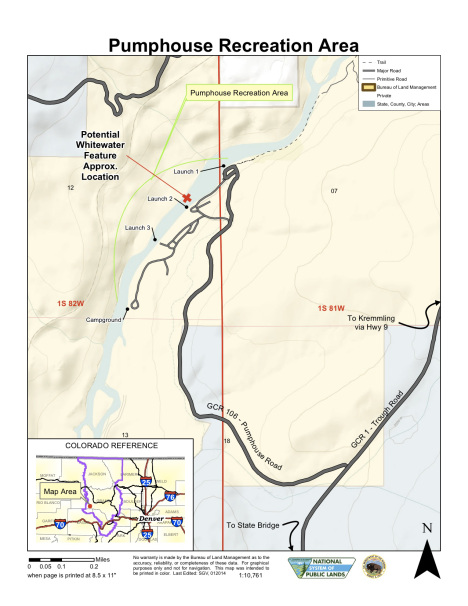
After five long years, the $1.7 million Colorado River enhancement project, known as Gore Canyon Whitewater Park, is now complete and open.
The Colorado Water Conservation Board needed to approve the implication of the recreational in-channel diversion (RICD), known commonly as a whitewater park. After the Grand County team showed 100 letters of support from kayakers and other recreationalists, the RICD was awarded.
The project’s fundraiser and coordinator, Caroline Bradford, explained the RICD and its promise for future generations and recreation.
“You have a manmade structure in the river that diverts the stream flow in order to provide whitewater for recreation,” Bradford said. “We want people to be able to play on the river for generations to come.”
To fund such a massive project, Grand County citizens and boaters donated more than $600,000 to the cause. Eagle County citizens donated $340,000; Colorado Basin Roundtable Basin Account Fund granted $100,000; Colorado Water Conservation Board granted $400,000; and the Colorado Department of Local Affairs provided $200,000.
To commemorate its completion, a Grand Opening Celebration of the Gore Canyon Whitewater Park will take place on July 13, from 11 a.m. to 1 p.m., followed by a rafting trip until 3 p.m.
The day’s activities will include a whitewater paddling exhibition hosted by American Whitewater, a formal ceremony, a catered picnic, and then the raft trip from Pumphouse to Radium.
The cost to raft is $62 per person, and you need to RSVP to Caroline Bradford by July 6 at carolinebradford@wildblue.net or by calling 970-688-0812.
Shirley Hotel Haxtun, Colorado via History Colorado FromThe Yuma Pioneer (Tony Rayl):
The Republican River Water Conservation District Board of Directors will hold its regular quarterly meeting Thursday, July 9, at the Haxtun Community Center, 125 E. Wilson St.
Among the items on the agenda is approving the purchase of surface water rights with Bonny Company Trust. The board also is supposed to receive a report from Mike Sullivan and Scott Steinbrecher from the State of Colorado concerning negotiations with Kansas regarding the Compact Compliance Pipeline and Bonny arbitrations. Some portion of that report might take place in executive session due to possible negotiation and litigation strategy considerations.
District engineer Jim Slattery will make a presentation regarding the pipeline operations in 2015, and a pipeline update will be given.
The 2014 audit report is up for approval, and the board also is scheduled to approve an engagement letter for the 2015 audit.
The meeting is scheduled to run from 10 a.m. to 4 p.m. Public comment will be heard by the board beginning at 1 p.m.
If needing more information, please contact Deb Daniel, the RRWCD’s general manager, at 332-3552 or 630-3525, or email her at deb.daniel@rrwcd.com. The district’s website is http://www.republicanriver.com.
It was called the May miracle in Colorado. After a ho-hum winter, it looked certain that the creeks and rivers would deliver a runoff that walked, not ran, that murmured instead of shouted.
In March, the weather became so hot that something happened in the Gore Range that usually doesn’t occur until June. The couloirs on the Grand Traverse, the 13,000-foot ridge overlooking Vail, became so saturated with melted snow that they slid to the ground. It’s called a called a climax slide, and it rarely happens before June.
“It was the most crazy thing I’ve ever seen,” said Darryl Bangert, who has been studying snow and river runoff in the Vail area since 1976.
Then, in mid-May, it started snowing—again and again. And when it didn’t snow it rained, continuing into June.
Last week, that snow and rain was evident as Colorado’s rivers became as crowded as a Chinese train station on a holiday. The rivers thrashed, they gnashed, they splashed in a hurry to get out of the mountains. There have been longer runoffs and higher runoffs, but it was impressive nonetheless.
Taking note of 11 snow-monitoring sites that he tracks, Chris Landry, from the Center for Snow & Avalanche Studies, reported that the rivers were more boisterous than the snowpack statistics would suggest. The water in the snow was short of the median for 1981-2010.
“Snowmelt runoff behavior has been (arguably much) more intense than these data would suggest,” he wrote carefully in a posting on his website.
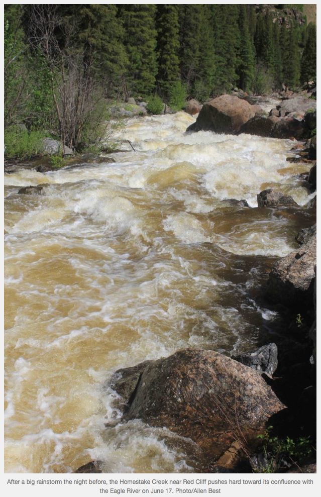
Eagle River June 17, 2015 via Allen Best
South of Vail, that unruly runoff was evident on June 17 in Homestake Creek. In a quarter mile before it flows into the Eagle River, the creek has an incline comparable to that of a green or beginner ski slope. The water was pounding, droplets flying high into the air. A misstep on the boulders adjoining the water would have meant almost instant death.
In the nearby town of Red Cliff, a long-time resident was asked whether the Eagle River had peaked yet. “Just a minute,” he said, “I have a rock that I can see from my house that I use for measuring the height of the river.” Returning a few minutes later, he observed that the water on the rock was indeed the highest it has been this year.
That was probably peak runoff for the Eagle River, a full 10 days later than the locally acknowledged long-term average for peak runoff. In recent years, the trend has been to earlier runoff.
Bangert, an owner of Sage Outdoor Adventures, said there were much bigger runoffs and longer runoffs, such as those of the early 1980s=. But this was stood out because it was pushed by big rainstorms.
Several people have drowned in rivers and creeks, mostly the result of kayaking, rafting, or inner-tube accidents.
The most unusual drowning occurred near Silverton, in the San Juan Mountains. The victim, who was 19, had moved to Durango to be with his dad. They were walking up a snowfield and the victim slipped and fell into a creek that was running below them, disappearing under the snow. The family dog jumped in behind him, San Juan County Sheriff Bruce Conrad told the Silverton Standard & the Miner.
The creek re-emerged from the snow 240 feet farther downstream, but the man’s body did not for three hours. The dog did later, but it was alive.
Beyond the individual tragedies, the big runoff in Colorado has implications up and down the Colorado River. Instead of 3 million acre-feet, Lake Powell will likely get 6.2 to 6.4 million acre-feet, said Eric Kuhn, general manager for the Colorado River Water Conservation District.
That allows the upper-basin states —Colorado, Utah, Wyoming and New Mexico – to release more water from Powell to flow downstream to Lake Mead, near Las Vegas. This additional water in Lake Mead should help water-strapped California.
Now the big question mark is what the El Niño will produce. The last one was in 1997-98, and that is the last good water year for the entire Colorado River Basin.
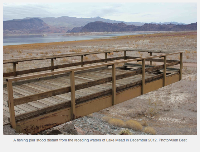
After a so-so winter, the snow piled up through May in the mountains of Colorado, taking the edge off drought. This takes the edge off of the big Colorado River reservoirs, Lake Mead and Lake Powell. But the overarching story at those reservoirs since 1999 has been of decline, even after a few big years.
In the last several years, there has been increasing talk about the potential for the two reservoirs to become empty. Las Vegas, reliant upon Lake Mead for most of its water, isn’t just talking about the possibility. It is nigh-on to completing a third tunnel into the reservoir, this one at a cost of $817 million and, unlike the others, at the very bottom of the reservoir, in case there’s nothing left of Lake Mead except for the Colorado River. That’s how dire Las Vegas, operating as the Southern Nevada Water Authority, takes this potential of long-term drought.
Eric Kuhn, the manager of the Colorado River Water Conservation District, spoke to the implications of this continuing drought at a forum in Colorado’s Summit County this spring. “Bad things happen when Lake Mead and Lake Powell get drained,” he said in an event covered by the Summit Daily News. He described the draining of Lake Mead as a distinct possibility in the next few years.
What about building a pipeline to the Mississippi River or some other water-rich location? “To expect that we can export our problems to somebody else, I just don’t see that somebody else will willingly accept them,” he said.
How about just making some more water? That effort began soon after World War II in different times of drought. Scientists at General Electric in New York state had discovered the general principle. And in some places of the West, cloud-seeding has occurred since the 1950s – including, at Vail Mountain, since 1978.
But does it work? Since the federal government yanked research dollars from cloud-seeding experiments in the 1980s, relatively little rigorous science had been conducted. Instead, there were the claims of commercial-cloud seeders, who predicted gains of 10 to 15 percent—as long as they had clouds to work with.
In 2004, Wyoming set out to fill that gap. An experiment that ultimately cost $14 million was designed by scientists working for a federal laboratory, the National Center for Atmospheric Research. Parallel mountain ranges southwest of Laramie, just north of the Colorado border, constituted the Wyoming laboratory. Propane was burned to loft silver iodide from ground-based generators into the clouds passing over the Sierra Nevada and Medicine Bow ranges. In the experiment, 154 storms during six winters had the temperatures needed for effective seeding, but only 118 had the moisture content. And of those, 18 were tossed out because of contamination problems.
Slim statistical evidence
Last December, at a meeting room in Cheyenne, scientists delivered the results. It took a full afternoon and the results were sometimes confusing. But hydrologists and meteorologists who listened to the proceedings remotely told me they had no trouble hearing the key statistics: just a 3 percent increase in precipitation but with the 28 percent probability that cloud-seeding had nothing to do with the increase. Only by creating models were researchers able to make a case that snowfall had been augmented 5 to 15 percent.
Taking stock of this and other winter weather-modification studies, the Bureau of Reclamation was unimpressed. “As such,” said the agency in a draft analysis released in February, “the ‘proof’ the scientific community has been seeking for many decades is still not in hand.”
Proof in science requires a 95 percent probability of causality. This is extremely difficult to achieve in complex atmospheric processes, whether cloud-seeding or many of the processes involved with a warming global climate.
In Wyoming, elected officials have decided the evidence to support cloud-seeding is strong enough to justify additional investments in various drainages—including the Wind River Range, which produces water for a tributary of the Colorado River—even as they have been loathe to admit the science of global warming.
Wyoming isn’t alone. Water agencies and cities from Denver to Los Angeles pay for seeding clouds in the mountains of Colorado and Wyoming, and representatives heard what they wanted to hear.
“It’s good evidence that it works,” said David Cole, who administers weather-modification programs for the Utah Division of Water Resources.
“There is always that question, ‘Can you prove it beyond a shadow of a doubt?’” he added.
From Los Angeles comes a similar appraisal of confirmation. “These results are consistent with historic studies,” said Tom Ryan, of Metropolitan Water District of Southern California, a consortium of agencies that collectively serves 18 million people.
I heard similar remarks from the Central Arizona Project, which uses a 336-mile-long system of aqueducts, tunnels, pumping plants, and pipelines to deliver water to Phoenix, Tucson, and cotton farms and golf courses along the way.
Along with Las Vegas, Arizona and California chip in to pay for cloud-seeding in Colorado and Wyoming.
Dan Breed, project scientist with NCAR, said that failing to achieve a 95 percent confidence level in results is not unusual in cloud-seeding studies. The fundamental problem, he says, is the complexity of atmospheric processes.
It’s the same challenge that has prevented most climate scientists from linking specific weather events, such as the September 2013 floods in Colorado, to rising global temperatures and the 3 to 5 percent observed increase in atmospheric moisture related to that warming.
“When it comes to the atmosphere, there are just too many variables, and that variability just keeps rearing its ugly head when it comes to cloud-seeding,” says Breed. “Even in this case, where we tried to make things as homogeneous as possible to reduce that variability, variability still kind of hurt us.”
Breed thinks research might better be invested in understanding specific atmospheric processes of wind, temperature, and precipitation. For example, how likely is it that silver iodide or other seeding agents released from the ground will get into the clouds?
Understandings of atmospheric processes, says Breed, has mostly come from observations, instead of experiments – because of that same variability.
This lack of certainty does not necessarily kill the prospects of cloud-seeding, as is demonstrated by the continued interest of Wyoming legislators in funding cloud-seeding.
Cloud-seeding to the rescue?
Can cloud-seeding the answer to the problems of California, now in its fourth year of drought, or of the Colorado River?
The river is notoriously strapped to meet all of the wants and maybe even the needs. River flows have declined 20 percent in the 21st century as compared to the last century.
Breed disputes conclusions that cloud-seeding doesn’t necessarily work. But he doesn’t see it as a game-changer for the Colorado River. Modifying the weather is a fairly straightforward, quick and inexpensive way to produce more water, but the gains are marginal. “It is not, he says, a magic bullet. “It won’t solve the problem.”
In his appearance in Summit County, Kuhn took a broad view, describing the 21st century as a time of transition. “After 100 years of develop more, develop more, develop more, we’re going to have to cut back our uses.”
That’s the difficult conversation now underway in California as residents in places like San Jose argue about lawn sizes and almond groves. It’s also the more earnest conversation that, despite the extraordinary rains in May, is getting underway in Colorado.
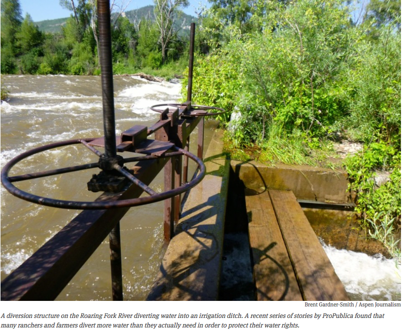
Diversion structure Roaring Fork River via Aspen Journlism FromAspen Journalism (Brent Gardner-Smith):
Ranchers and farmers in western Colorado are incentivized to divert more water from the state’s streams and rivers than they need, an investigative reporter with ProPublica said at the Aspen Ideas Festival last week.
Abrahm Lustgarten, whose series “Killing the Colorado” is now being published by the nonprofit news organization, said that Western water laws “have become so antiquated that they now actually undermine conservation. They actually incentivize people to waste their water and use it in inefficient ways.”
And given the “use it or lose it” ethos that surrounds water rights, Lustgarten said that “landowners with rights wind up taking every drop that they are allowed out of the rivers, year in, year out, in order to prove up the need for their water.”
Lustgarten, who has won national awards for his environmental reporting at ProPublica, spent time with ranchers and ranch managers in the Gunnison area as part of the two years of research he put in for his stories.
Referring to Bill Ketterhagen, who runs a 750-acre ranch in the Ohio Creek valley, Lustgarten said “he and other ranchers tell me that if the law allowed them to use less water, without jeopardizing their legal rights to take it in the future, or if they could bank it — save it for a dry year — that they would.
“They could grow the same crops for the same profits, with less water. But instead, he diverts as much as he possibly can, even if it means letting the downstream streams run perfectly dry, and then pours it liberally over his own fields, basically whether he needs it or not.
“No one that I talked to harbors any illusions that this is sustainable,” Lustgarten said. “It’s a question of how many more years can the good times be strung along.”
(To listen to Lustgarten’s presentation, see the audio track below. The portion of his presentation that is quoted above begins shortly after the 20 minutes and 45 seconds mark, or at 20:45).
Set up for conflict
In “Killing the Colorado,” Lustgarten also explores cotton farming in Arizona, and how it is subsidized by the federal government, and how a huge coal-fired plant near Page burns coal to pump water through Arizona.
He also tells how the Colorado River has been shaped by the Colorado Compact of 1922, and how it overestimated the river’s annual flow, and thus the amount of water to be shared by seven states, including Colorado.
“The entire premise of the water supply for 40 million Americans amounts to wishful thinking,” Lustgarten said.
That point is also frequently made by filmmaker and photographer Peter McBride, who grew up in the Roaring Fork River Valley and since 2009 has been telling vivid stories about the challenges facing the Colorado River, and its dried-up delta.
“Part of the problem is that in 1922 they thought the river flowed at a higher rate than it does historically,” McBride said during an individual presentation at the Ideas Fest on Monday. “They called it a large soda, and we now realize it is a medium soda. But the compact agreement is based on a large soda. And all the straws are still in that, even though it is a medium. So we’ve totally bypassed the production of the river.”
During a following panel discussion on drought, McBride said the Colorado River consistently is last in line for its own water.
“Who is going to shoulder the deficit?” McBride asked. “Is it going to be ag? Are municipalities going to become more efficient? Or is it going to be the river? Often, in more cases than not, the river loses.
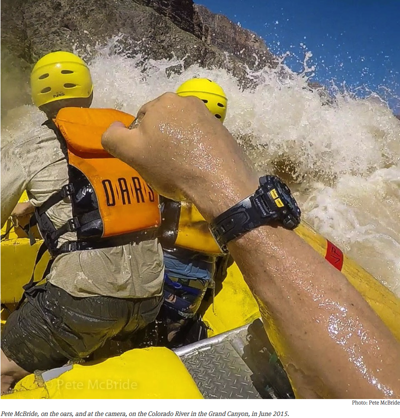
“Most people, from my experience, they like the thought of a river,” said McBride, who was just back from rowing the Colorado through the Grand Canyon. “But when push comes to shove, and when it comes down to having a pool or not, or a golf course or not, or a tap or not, they vote tap. They vote pool. So as we are struggling to figure out this water shortage, often times the river will continue to lose.”
Peter McBride at the oars and cameral Grand Canyon June 2015
Ag. v. city v. river
Lustgarten and other panelists at the Ideas Fest pointed out that the primary competing interests for Colorado River water are agriculture, cities and what’s left of the river’s ecosystem.
“The consensus that I hear is that inevitably the most give will come from agriculture, like it or not, because that’s where the most water is,” Lustgarten said. “And there is huge opportunity for very a small-percentage efficiency gain to translate to a volume of water that is very meaningful to a lot of the cities.”
Lustgarten also said that “cities will bring money, agriculture will eventually bring water. But the law is on agriculture’s side. And if there is anything that is political an untouchable, especially in the West, it is private property rights, and that’s how water is seen.”
Buzz Thompson, a professor of natural resources law at Stanford University, made a similar point about the West’s “first-in-time, first-in-right” system of water law during Monday’s panel on drought.
“There have been a variety of suggestions recently to try replace the prior appropriations system with a totally different system of water allocation,” Thompson said. “It would take at least a century or two, however, to get through the politics of actually doing that. And furthermore you have a problem with the United States Constitution and those state constitutions that protect private property.”
Both of the water panels at the Ideas Fest discussed the lack of transparency and accountability when it comes to the ownership and use of water in Western states.
“There are variety of states in the United States that still are not absolutely sure exactly how much water they have and who is using it,” Thompson said. “In California, we have this very complex water system, and the truth of the matter is we don’t actually know exactly how much water a variety of water rights owners are entitled to.”
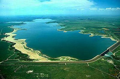
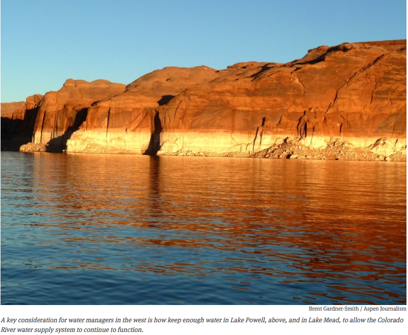
Lake Powell via Aspen Journalism
Changing attitudes
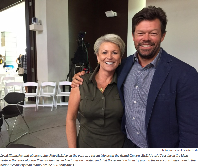
Patricia Mulroy, who ran the Southern Nevada Water Authority from 1993 to 2014 and is now at the Brookings Institution, sat on Monday’s panel and said the last 20 years have brought about an evolution in water policy.
She said the big players in the broader Colorado River community are now working together to preserve the existing water supply system in the face of drought, climate change and a growing population.
Mulroy said the new consensus is, “Let us conserve both with ag and with urban before the system crashes. And let us use urban dollars to effectuate conservation measures both in the urban areas and in the agriculture areas.”
“Because here’s the reality,” Mulroy said, pointing to the current record-low levels of water in Lake Mead. “All those lovely paper water rights that we have spent millions paying our lawyers to protect become absolutely useless at some point. It doesn’t matter whether you are the holder of the most senior Colorado River water right given to you by the Supreme Court. Nature doesn’t really give a tinker’s damn.”
Peter McBride and Pat Mulroy at the Ideas Festival June 2015
Saving water to grow?
But Thompson, the law professor from Stanford, warned that too often conservation gains are then used to provide water for new development.
“Frequently we are using that conversation to permit expanded growth,” Thompson said. “ And so then what happens is that the next time we have a drought, we’ve already used up that conservation, and it becomes even more difficult to withstand that particular drought.
“At some point,” Thompson said, “we have to realize there is a limited capacity for increased population in the Western United States, and recognize what John Wesley Powell did, which is that we have to link our land use planning with our water resources.”
Editor’s note: Aspen Journalism, the Glenwood Springs Post Independent and The Aspen Times are collaborating on coverage of rivers and water. The Post published this story online on July 4, 2015.
Mired in drought and torched by one of the hottest years ever measured, the seven states of the Colorado River Basin are acutely aware of how a desert can bully water supplies. They are not alone. In this cauldron of collaboration and competing interests is a collection of players who are just as significant for managing and responding to water scarcity but attract much less attention: the basin’s 29 federally recognized Indian tribes.
With the oldest claims to water, the tribes command a considerable role in directing the region’s future. Combined, they hold rights to a substantial portion of the Colorado River’s flow: roughly 20 percent, or 2.9 million acre-feet, which is more water than Arizona’s allocation from the river. The tribal share, moreover, will increase, perhaps by as much as hundreds of thousands of acre-feet as the 13 tribes without confirmed rights settle their claims with federal and state governments.
Years of careful negotiations, spurred by a desire to avoid long-running court battles, produced legal settlements that provide water for tribes, cities, and industries. Beneficial to all sides, the settlements were a catalyst for urban development and a tool for funding Indian water systems. Perhaps more importantly, the settlements are the foundation of a partnership, an inescapable union, between tribes and their neighbors, a union that will grow in importance as water becomes scarcer in the warming and drying American West.
“We’ve developed tremendous and valuable relationships with each other from being in the same room for years,” Kathryn Sorensen, director of the Phoenix water department, told Circle of Blue. “Water is always important and contentious in Arizona. But having relationships helps you have conversations when you want new solutions.”
San Juan River from Wolf Creek Pass From the Pagosa Sun (Casey Crow):
The board of directors for the San Juan Water Conservancy District (SJWCD) voted unanimously on June 29 to accept an agreement regarding the loan restructuring for the Dry Gulch water storage project with the Colorado Water Conservation Board (CWCB), following a green light from the Pagosa Area Water and Sanitation District (PAWSD) last week.
According to a letter drafted by Rod Proffitt, president of the SJWCD, the district has limited water storage capacity to meet future water needs. The demands placed on the district for wildfire protection, drought and habitat are great and unsustainable. A situation worsened by state officials who used water from a tributary of the San Juan to offset the over-appropriation of the Rio Grande.
The water needs of the community led the district to partner with PAWSD, with the goal of building a water storage facility.
The Dry Gulch water storage project was halted due to the recession and changes occurring within PAWSD leadership, which then changed the direction of the project altogether.
The Colorado Supreme Court turned back four challenges Monday from San Luis Valley surface water users who objected to the operations of a groundwater management subdistrict.
The court’s opinion written by Justice Monica Marquez upheld rulings from the Water Division No. 3 Court in 2012 and 2013 that, among other points, allowed Subdistrict No. 1 to use groundwater from a federal reclamation project to mitigate the impacts of groundwater pumping.
In 2012, the subdistrict, which takes in 3,400 wells in the north-central valley, issued its first annual plan on the steps it would take to eliminate injury to senior surface water users and restore the aquifer.
The plan, which was approved by the Office of the State Engineer and the local water court, included the proposed use of 2,500 acre-feet from the Closed Basin Project as a source of replacement water. Objectors argued that the project itself caused injury to users along the Rio Grande, because the groundwater it draws from is tributary to the river and any withdrawals in the overappropriated basin is presumed to cause injury.
The state Supreme Court ruled against that argument, noting that objectors offered no proof that the project’s water was tributary to the Rio Grande.
Further, the court found that the use of project water did not violate its initial decree, nor interfere with the state’s ability to meet its obligations under the Rio Grande Compact.
The court also ruled that the subdistrict’s annual plan to replace injurious depletions did not have to be set aside pending the resolution of objections.
Moreover, its handling of augmentation wells in the annual replacement plan was legal.
Objectors included the San Antonio, Los Pinos and Conejos River Acequia Preservation Association, Save Our Senior Water Rights, Richard Ramstetter and the Costilla Ditch Co.
While high water has shut down parts of Lake Pueblo, it has opened up new opportunities at John Martin Reservoir 100 miles to the east.
“The reservoir hasn’t looked like this in a long time,” said John Martin State Park Manager Dan Kirmer. “If you haven’t been to the reservoir before or haven’t been in a while, you definitely need to come check it out.”
John Martin, which has been at extremely low levels for the past 15 years, now has more water than Lake Pueblo. As of Monday, John Martin had about 295,000 acre-feet, the most water it has seen since 1999, while Lake Pueblo contained about 284,000 acre-feet.
There are 200 campsites and 5 miles of hiking trails to explore, and nearly 400 species of birds at John Martin Reservoir as well.
The water level continues to rise as the reservoir is storing more water than is being released because of snowmelt, upstream flood control at Lake Pueblo and heavy precipitation so far this year.
Water levels in Lake Pueblo are slowly dropping, as water releases continue at a high level, while inflows from the Arkansas River to the west have slowed down. Many areas of Lake Pueblo State Park, including the south shore boat ramp, are closed until the high water subsides.
Meanwhile, the Arkansas River through Pueblo remains closed because of dangerously high water levels. Water stored during earlier floods is being released as quickly as possible from Pueblo Dam to reserve capacity if more flooding occurs this summer.
he Lower Arkansas Valley Water Conservancy District Wednesday voted to apply to the state for a $2.5 million loan to purchase Colorado Canal shares.
The district purchased 408 shares of Colorado Canal water from Ordway Feedyard in November and was working with the company to finance the deal.
The goals were to keep the financially troubled feedlot in business and to keep the water in the Arkansas Valley.
However, the feedlot continued to fall on hard times and will be auctioned in July, so the Lower Ark district needs to finalize the sale.
The district is seeking the loan from the Colorado Water Conservation Board at a 1 percent interest rate, which is an improvement over a 4 percent bridge loan from an area bank, General Manager Jay Winner explained.
The Colorado Canal once irrigated 50,000 acres in Crowley County, but has largely fallen into the hands of Colorado Springs and Aurora through purchases made in the 1980s.
More Lower Arkansas Water Conservancy District coverage here.
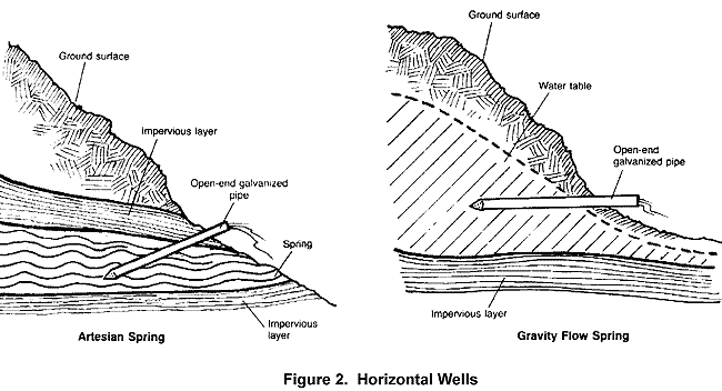
Horizontal water wells via LifeWater.org FromThe Pueblo Chieftain (Chris Woodka):
The Arkansas Basin Roundtable Wednesday approved four area water projects totalling about $1 million.
The roundtable’s decisions clear the way for the Colorado Water Conservation Board to consider funding the projects through its Water Supply Reserve Account. The account is funded through mineral severance taxes.
The Fort Lyon Canal is seeking $500,000 to replace the Horse Creek flume, a 392-foot-long, 10-foot diameter steel pipe constructed in 1938 that is at risk of failing after years of repairs.
The pipe is designed to carry the full volume of the Fort Lyon Canal, up to 1,800 cubic feet per second, over Horse Creek.
If it failed, hundreds of people’s homes could be flooded.
The full project would cost $2.2 million and is expected to be complete by next April.
The Box Springs Canal Co. in Crowley County, mostly members of the Markus family, is seeking $200,000 to restore a system of wells built in the early 1900s to support research by the D.V. Burrell Seed Co. and later companies looking at plant genetics.
There are five reservoirs in the system that now irrigates 240 acres, compared with 6,000 acres originally.
Garrett Markus, a water engineer, explained three horizontal wells are needed to replace 15 vertical wells that failed or are not producing.
Lamar is seeking $160,000 to redevelop two wells that were taken out of use. The new purpose of the wells would be for nonpotable water that could be used to irrigate Lamar’s cemetery and golf course. The total cost is about $400,000.
A $250,000 study would look at a study of collaborative storage in the Cucharas River basin. While there are numerous reservoirs in the basin, many are under state restrictions, Sandy White of the Huerfano Conservancy District explained.
A river once left for dead by mine-polluted runoff in the southwestern corner of the San Luis Valley is coming back to life.
The Alamosa River, which once included a 17-mile dead-zone thanks to the Summitville gold mine, has seen the return of fish and a local group is seeking to keep it that way by adding to the river’s flows.
“We still have a ways to go but we’ve done a lot,” said Cindy Medina, head of the Alamosa Riverkeepers.
The group is close to finalizing a pair of in-stream water rights in court that could add as much as 550 acre-feet per year to the river below Terrace Reservoir where it runs to the valley floor.
That amount, which translates to roughly 180 million gallons, would be stored in the reservoir and released during times of the year when flows are low to nonexistent.
Last week, the Colorado Water Trust honored Medina for her work on the Alamosa with the David Getches Flowing Waters Award.
Key to the in-stream flows, which also would boost groundwater levels in the area, was the cooperation of the Terrace Irrigation Co., which has made storage space available in the reservoir.
Medina also credited landowners along the river like Joe McCann and Rod Reinhart.
“Both of them have been instrumental in this project,” she said. Reinhart, who grows alfalfa and barley north of Capulin, said he came to understand the importance of riparian habitat and how the in-stream flows could help.
But the importance of how they might help the aquifer also was important given the looming groundwater regulations that might face the valley.
“I think that is huge,” he said. “That’s a big help.”
The need for the restoration on the river and part of the means to do so, stem from the legacy of the Summitville gold mine, which sits at an elevation of 11,500 feet on a tributary.
Summitville Mine superfund site
In 1986, the Summitville Consolidated Mining Company began operation of an open-pit mine on 1,200 acres and used a cyanide formula to extract gold from ore.
A faulty liner meant to contain the cyanide and a company-installed water treatment plant that was far too small ensured high levels of pollutants migrated downstream.
By 1990, fish were gone from the reservoir and the stretch of river above it.
After six years of operation, the company declared bankruptcy and abandoned the site, forcing the Environmental Protection Agency to take over emergency management of the property.
The mine was designated a Superfund site in 1994.
Prosecution of the mining company led to a $28.5 million settlement, $5 million of which was set aside for restoration work in the watershed.
The work of the riverkeepers to increase stream flows is one of the legacies of that funding.
Water quality on the river improved after the Superfund designation, enough so that state wildlife officials began stocking trout in the reservoir in 2007.
In 2011, a permanent treatment plant was built with $19.2 million in federal stimulus funding.
“That improved the water quality significantly,” Medina said.
One year later, the Colorado Department of Public Health and Environment lifted restrictions on the consumption of trout in Terrace Reservoir.
Medina is among those who have eaten trout from the reservoir.
“They’ve come out fine,” she said.
But the riverkeepers hope to add more water to the river, by buying water rights from others.
Their goal is to reach 2,000 acre-feet of in-stream flows.
“We’re always looking for more water for the river,” she said.
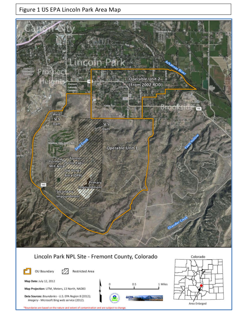
Lincoln Park/Cotter Mill superfund site via the Environmental Protection Agency FromThe Pueblo Chieftain (Tracy Harmon):
State and federal health officials are inviting the public to submit informal preliminary comments on the Cotter Corp. Uranium Mill’s Draft Quality Management Plan.
The 53-page plan outlines quality assurance, training, implementation of work, record keeping, response and corrective action protocols for the now-defunct mill as it moves toward decommissioning. The mill has been an EPA Superfund site since 1984 due to the seeping of uranium and molybdenum contamination into groundwater and soil which was caused by the use of unlined tailings ponds.
Statewide Basin High/Low graph July 3, 2015 via the NRCS
Arkansas River Basin High/Low graph July 3, 2015 via the NRCS
Upper Colorado River Basin High/Low graph July 3, 2015 via the NRCS
Gunnison River Basin High/Low graph July 3, 2015 via the NRCS
Laramie and North Platte Basin High/Low graph July 3, 2015 via the NRCS
Upper Rio Grande River Basin High/Low graph July 3, 2015 via the NRCS
San Miguel, Dolores, Animas, and San Juan Basin High/Low graph July 3, 2015 via the NRCS
South Platte River Basin High/Low graph July 3, 2015 via the NRCS
Yampa and White Basin High/Low graph July 3, 2015 via the NRCS
Click on a thumbnail graphic to view a gallery of Basin High/Low graphs for the snow season.
FromThe Pueblo Chieftain (Chris Woodka) [June 3, 2015]:
Now that the rain, snow and cold temperatures have eased up, at least until the weekend, it’s time for spring runoff.
The runoff is about two weeks later than usual, although “usual” is becoming more difficult to define. National Oceanic and Atmospheric Administration models show that cooler, wetter weather is expected in Southern Colorado through the summer and into next fall.
Rafting companies are anticipating a good season, according to news releases from the Arkansas River Outfitters Association that called current flows “optimal” for every skill level. Flows on the river at Parkdale, west of Canon City, were at 2,300 cubic feet per second and climbing on Tuesday.
“I would say we are in a runoff pattern now,” said Division 2 Water Engineer Steve Witte. “We’re seeing those peaks and valleys in the data. In those years where we have a cool, wet May, it can delay the peak runoff until the end of May.”
Gauges on high-mountain tributaries of the Arkansas River are showing diurnal flows that pick up until about midnight as afternoon snow melts and then drop off during freezing temperatures in the night.
Flows on the Arkansas River are picking up, partly because of the runoff that started in the last week and partly because of the balancing of reservoirs.
The Bureau of Reclamation is making more space in Turquoise Lake and Twin Lakes for anticipated imports, meaning some additional water is moving through the Arkansas River to Lake Pueblo. About 10,000 acre-feet is being moved. An acre-foot is 325,851 gallons.
The Army Corps of Engineers released the last bit of 12,000 acre-feet of stored flood water from Lake Pueblo on Saturday.
Some canal companies are beginning to take water — it was too wet during May for most farmers to start planting, other than some small windows of opportunity.
The result is that John Martin Reservoir has reached its highest point since April 2001, and was storing about 175,000 acre-feet as of Tuesday.
“It looks like we will be in conservation storage for a while at John Martin,” Witte said. “Water is also flowing into the Great Plains Reservoirs (located in Kiowa County and owned by the Amity Canal in Prowers County), which is something of an anomaly.”
Levels at John Martin were just 6,300 acre-feet in November, and had increased to 53,000 acrefeet by the end of winter storage in early April. But those levels dropped to 45,000 acre-feet by May 7. Since then, 3,00010,000 acre-feet daily have been stored in the reservoir.
The snowpack followed a similar pattern. April was a dismal month for accumulation, and it looked like the snowpack would be puny until the first of May.
Because of locally heavy snows in February, however, Reclamation was still forecasting a nearly average year for the Fryingpan-Arkansas Project on May 1. That’s improved considerably.
“Unofficially, we think it’s going to be 20 percent more,” said Roy Vaughan, manager of the Fry-Ark Project. “One of our biggest concerns is that it could come off too fast.”
Snow peaks throughout the state are well above normal, because of additional late snow in May. However, the mid-April peaks that usually occur never came because of the earlier dry conditions.
The Fry-Ark Project brings water from the upper reaches of the Roaring Fork watershed through the Boustead Tunnel into Turquoise Lake, but if snow melts too quickly, the tunnel can’t capture all of the water that might be available.
Meanwhile, Fountain Creek in Pueblo was running at about 830 cfs Tuesday, about 20 times the normal rate.
Meanwhile, managing streamflow to prevent flooding was a balancing act a couple of weeks ago along the Arkansas River. Here’s a report from Chris Woodka writing for The Pueblo Chieftain:
Lake Pueblo is just a couple of weeks from completely filling, if current weather patterns continue.
That could mean water stored in the reservoir could begin spilling — on paper at least, but in reality as well.
Water is being stored to prevent flooding downstream of Pueblo Dam. It boils down to a simple math problem that seeks to keep the Arkansas River flow at Avondale below 6,000 cubic feet per second. That satisfies most downstream direct-flow rights, while protecting downstream Because of high flows on Fountain Creek, unmeasured flooding on Chico Creek and occasional downpours over the St. Charles River, releases from Pueblo Dam have been cut back.
“We have been conservative because we don’t have advance warning of other water that might be coming in,” Steve Witte, Division 2 engineer with the Colorado Division of Water Resources, told the Southeastern Colorado Water Conservancy District Thursday.
Normally, the same amount flows out of Lake Pueblo as flows in. But during this period, about 6,000 cfs has been flowing in each day, too much to add to the Arkansas River below.
The result: About 30,000 acre-feet of water are backed up in Lake Pueblo.
An additional 4,500 acrefeet continues to be stored daily. Flood storage tops off at 90,000 acre-feet, or about 14 more days at the current storage rate, said Roy Vaughan, Fryingpan-Arkansas Project manager for the Bureau of Reclamation.
Lake Pueblo had about 275,000 acre-feet of water stored Thursday. Its physical capacity is about 350,000 acre-feet. (An acrefoot is 325,851 gallons.) “We’re trying to evacuate the water as quickly as possible,” Witte said.
That could take some time, because more water is being stored than released.
Pueblo Dam releases were stepped up Thursday after being cut on Tuesday to accommodate a wall of water moving down Fountain Creek from overnight rain in the Colorado Springs area. That followed a similar cutback a week earlier. About 5,000 cfs can be safely released, if conditions remain dry.
The National Weather Service predicts generally hot, dry weather through at least next Wednesday.
At the same time, spring runoff continues to run full throttle from the mountains in the Upper Arkansas River basin, pushing flows above the 6,000 cfs figure. There still appears to be ample snow in the mountains to prolong the peak.
On top of that, more water is being brought in by the Fry-Ark Project, which is now filling Turquoise Reservoir. Other transmountain diversions, by Twin Lakes, Colorado Springs and the Pueblo Board of Water Works are shut down because there’s no place to put the water.
Even if Pueblo is not completely filled, some non-project water could spill if Reclamation imports more than the 70,000 acre-feet now projected or if its Arkansas River basin water rights come into priority. Right now, there are about 57,000 acre-feet of excesscapacity water and 40,000 acre-feet of winter water that could spill under the right set of circumstances.
Water officials are working to keep the water moving and avoid that scenario, however.
Things are wet in the San Luis Valley also. Here’s a report from Matt Hildner writing for The Pueblo Chieftain:
For the second year in a row, local water officials have seen more water come down the Rio Grande and Conejos River than winter snowpack measurements predicted.
While that made for a pleasant early June as irrigators got more water than they expected for their pastures and crops, the Colorado Office of the State Engineer has since had to increase curtailments to meet the Rio Grande Compact. Under curtailment, a percentage of the river is sent past headgates downstream to New Mexico.
On the Conejos, which had only a 5 percent curtailment in May, it was 43 percent as of June 22.
“Hopefully we’re at the point where we don’t have to do it anymore,” Craig Cotten, division engineer said.
At the beginning of May, streamflow forecasts from the Natural Resources Conservation Service had called for an annual streamflow total of 145,000 acre-feet of water on the Conejos where it enters the San Luis Valley floor.
Now that forecast is 275.000 acre-feet, which raises the bar for how much the state must send down stream to New Mexico for the remainder of the year.
“That really highlights the need to have better forecasting and that’s definitely something that we’re working on,” he said.
This year a pilot project funded by the Colorado Water Conservation Board, has flown a plane with Lidar technology over both the Conejos and Rio Grande basins to determine its effectiveness in measuring in snowpack.
Lidar is a remote sensing technology that measures distance by illuminating a target with a laser and analyzing the reflected light.
By flying in both winter and summer months, the difference in distance measured by the Lidar can offer information about the extent of the snowpack.
Cotten said local and state officials are also forming a steering committee that will look at the feasibility of using, Lidar, radar and additional snow gauges.
Cotten said NRCS is also investigating how fire burn scars and beetle-killed trees in the San Juan Mountains may be impacting runoff.
The forecasting hiccups also hit the Rio Grande this year but its 16 percent curtailment is less severe than on the Conejos.
The river is expected to see an annual total of 630,000 acre-feet at the Del Norte gauge, up from a May forecast of 445.000 acre-feet.
Despite the unexpected bumps in flows, this year will likely be the fifth year in a row below the historic average on the Conejos and the seventh on the Rio Grande.
Large chunks of the bank plunked into Fountain Creek Wednesday evening as Pueblo County Commissioner Terry Hart got a close-up look at the damage to Overton Road.
Two large wooden utility poles floated in the muck below, as the river cut back from the west base of the old Pinon Bridge, which washed out in the 1999 flood. After it slammed back into the east bank, it ran along the channel into a clump of trees. By morning the trees and part of the road would be gone.
“This is unbelievable,” Hart said. “The engineers tell us that Fountain Creek acts like a firehose, the way it moves around.”
Neighbors soon gathered at the spot. One of them was Tony Faxon, bringing his two children home to his 90-acre farm on Overton Road. He was worried about his well, which he had fortified a few days earlier after the last round of floods.
“It looks like the Washington Monument now,” Faxon said on Friday.
He explained the well is now a pole sticking 30 feet into the air — about half of its total depth.
He’s lost a chunk of land 80 by 500 feet and 30 feet deep so far this year.
While the house is on higher ground, he’s now faced with putting in a new well.
The Faxons have lived on Overton Road for four years.
“It’s been an ongoing struggle, but this has been the worst year,” Faxon said. “We couldn’t have anticipated this would happen.”
He’s not alone.
‘We need help’
At Friday’s meeting of the Fountain Creek Watershed Flood Control and Greenway District, which Hart chaired, a litany of damage was recited.
“We need some sort of help,” said Tracy Tolle, who farms for Frank Masciantonio in Pueblo County and Clear Springs Ranch in El Paso County.
“That’s our livelihood.”
Tolle has fought Fountain Creek for years and has seen it through higher water than what was flowing last week.
But the sustained midrange flows for weeks on end and saturated ground are taking their toll.
From his perspective, the actions of one landowner to wall off water just moves the river to the other bank, where the damage is amplified.
John Browning, who has a place on the east side of Fountain Creek in El Paso County, agrees.
He said fortifications on the west bank have created 50-foot cliffs where children play on the other side.
“You need to take care of both sides of the creek,” Browning said.
“Something needs to be done several decades ago.”
Jane Rhodes, Masciantonio’s sister and a Fountain Creek board member, brought pictures and descriptions of damage at a dozen places along Fountain Creek in Pueblo and El Paso counties.
Irrigation headgates are gone, acres of pasture and fields have vanished and wells wiped out by the whipsaw motion off the water over the past few weeks. Water snaked around one end of the new Pinon Bridge, setting up the possibility of future erosion.
Down the drain?
Up in El Paso County, a demonstration project sponsored by the Fountain Creek district — a showpiece that would show landowners how to use natural materials to turn the current — is gone, landowner Ferris Frost said.
Barriers set up to protect an organic gardening spot are washing away.
“The main channel is cutting through our headgates,” Frost said.
“It’s huge and fast . . . really extreme.”
The Fountain Creek board had few answers for landowners seeking help.
The district has no money, as it is awaiting $50 million from Colorado Springs Utilities when Southern Delivery System goes online. Ironically, SDS has permit issues ahead related to Colorado Springs’ failure to provide a stable source of funding for stormwater control.
Three weeks of rain have also cast clouds over some of the district’s activities, not just the Frost Ranch demonstration project.
“There is debris everywhere,” Hart said, telling the Fountain Creek board he has been watching the damage daily. “There is a lot of destruction going on and this is just the beginning.”
The city of Pueblo was getting ready to fire up its sediment collector again before the rains hit. The collector, installed four years ago when Fountain Creek was behaving itself, ran for a few weeks before a big wave buried it. It’s now under about three feet of sediment.
“We wanted to see if we could make it work without having to build coffer dams,” said Jeff Bailey, stormwater superintendent for the city of
Pueblo. The district also pushed for a demonstration project behind the North Side Walmart, where a detention pond and wetlands was constructed. The pond’s embankment partially washed out in the 2013 flood — and is probably eroding this time around — it’s been difficult to check. The pond has not had an impact on really large flows through Pueblo.
“Right now, it’s a money pit for us,” Bailey said. The city has to augment water stored in the area as well as maintain the pond.
There have been some things that work on Fountain Creek.
Things that work
At Clear Springs Ranch, which is owned by Colorado Springs Utilities on the east side of Interstate 25 near the Ray Nixon Power Plant, a ditch diversion structure across Fountain Creek was built in the 1970s. It survived the 1999 flood, but posed a problem for small native fish. A million-dollar fish ramp was constructed to help the fish get through.
In Pueblo, the city built rock jetties several years ago behind the Target Store on the North Side after Fountain Creek cut perilously close to the area in 1999. Those have held up through high water events as well.
The district still is studying construction of a dam or series of detention ponds along Fountain Creek to hold back the water and release it at more opportune times, but that effort is mired in a study of how to satisfy downstream water rights. In the meantime, Fountain Creek is playing ping-pong with land along its banks. Shoring up one side sends the water to the other and new channels are constantly being cut. While cities and counties have applied for disaster aid as roads, parks, trails and homes are threatened, the farmers are losing ground they’ll never get back. There’s no clear path for financial aid to the property owners.
“There’s a domino effect,” Tolle said, saying he thinks a multimilliondollar project built by Colorado Springs at Clear Springs Ranch may have breached in recent flooding. “Those ponds are not going to work.
You’ve got to give us help or there won’t be any farms.”
Meanwhile, Colorado Springs is looking at changing building codes to help minimize runoff into Fountain Creek. Here’s a report from Chris Woodka writing for The Pueblo Chieftain:
After the recent stomping by Mother Nature, the Fountain Creek technical team dug out the playbook Wednesday.
Like any team, the group is focused more on future victories and overcoming challenges than dwelling on past mistakes.
The team in this case is the technical advisory committee of the Fountain Creek Watershed Flood Control and Greenway District. It includes planners and engineers from Pueblo and El Paso counties, including the cities of Pueblo and Colorado Springs.
A big part of reducing future damage from flooding on Fountain Creek will be requiring future development — whether it’s a new project or redeveloping areas — to make sure flooding is not intensified by new hard surfaces such as streets, parking lots, sidewalks and roofs that prevent water from soaking into the ground.
“So often the developers design the development and tell the engineers, ‘Here, make it work.’ But urbanization almost always spurs the need for channel stabilization,” Steve Gardner, of the Colorado Springs stormwater department, told the group.
Gardner was explaining a drainage criteria manual Colorado Springs has developed in response to years of meetings that have improved understanding of Fountain Creek’s destructive nature. The earlier versions of the drainage manual supported projects that dumped water as quickly as possible into the waterway from flooded streets.
The new approach is to mimic natural conditions with techniques that encourage infiltration, move water through wetlands where possible and build detention projects that will handle a full spectrum of floods, Gardner said.
But it’s difficult to make up for the mistakes of the past, when many of the hills in Colorado Springs were paved as the city grew. One of the tough realities is that stormwater detention projects require land. Apparently, the government will take ground so the water won’t.
“Land allocation is a critical component,” Gardner said. “To get the water to spread out, you need more land. Urbanization results in taller peaks.”
That was seen during the May floods on Fountain Creek, the most recent of events where the creek turned into a river that ate banks, ripped away roads and changed course. With the ground saturated by weeks of rain, there was no opportunity for infiltration.
In that case, the drainage criteria manual recommends detention ponds to hold back the water, which also require land. A series of smaller ponds on tributaries would cost less to build and require less maintenance, Gardner said.
Such a system would allow localized storms to be contained, while reducing the cumulative effect on the creek. Among options studied by the U.S. Geological Survey, that system does not provide as much protection to Pueblo as larger detention ponds or a big dam.
Like any game plan, it has to be executed well to work. Issues still remaining include incorporating the drainage criteria manual with site planning, floodplain management on a larger scale, project phasing to make sure each project fits with others and adopting the same criteria throughout the entire 932-square-mile Fountain Creek watershed. Colorado Springs also faces challenges for funding a backlog of more than $500 million in stormwater projects in a way that satisfies Pueblo County and the Lower Arkansas Valley Water Conservancy District.
But standards for future development are an important step. Gardner said some developers are talking with the city and finding that things like natural infiltration channels can become amenities that increase property values.
“A lot of folks are stuck in the old way of doing things,” Gardner said.
It’s going to take a lot of dough and some big projects to fix problems on Fountain Creek. Here’s a report from Chris Woodka writing for The Pueblo Chieftain:
It’s going to take big projects to tame Fountain Creek. Even a $4.2 million project by Colorado Springs Utilities to redirect Fountain Creek into a less damaging course suffered damage from the June 15 storm surge after holding up reasonably well during relentless rain in May.
But a series of smaller attempts to protect property by armoring it with piles of concrete or a living shield of plants were swept away in the raging waters.
And the district that was formed to find the best way to fix Fountain Creek has no money and unfinished plans on how to mend the monster.
“There’s good news and bad news,” said Pueblo County Commissioner Terry Hart. “The good news is that the district has the authority to handle the entire watershed. The bad news is that there’s a lot to study and we’re still trying to understand how this works.”
Even when the Fountain Creek Watershed Flood Control and Greenway District figures out the best way, there remains the question of money.
“There isn’t an unlimited source of money,” said Pueblo City Councilman Dennis Flores. “Our task is to find out what will work with the amount of resources we have.”
So far, not much is working, the Fountain Creek board learned from presentations Friday.
As part of its commitment to the Bureau of Reclamation and Pueblo County for the Southern Delivery System, Utilito ties is required to restore wetlands, and its $4.2 million Clear Springs Ranch project was the way to achieve that. In fact, the Army Corps of Engineers certified the work in January, said Allison Moser, an engineer for Utilities.
The project covered 6 acres, fixed a past erosion cut and routed Fountain Creek away from the bluff to the west, which it had been undercutting. Thousands of plants were just getting established after being planted last year. The spreading wetlands were designed to handle the overflow of Fountain Creek during high water without sacrificing ground.
But the May storms deposited silt over much of the area and began to damage the bank of a channel that had been reinforced with 2-foot boulders.
“We really saw a lot of sedimentation, but the wetlands were designed to handle sedimentation,” Moser said. “The intention was to have the plants fill in over 10-15 years, but it took it in just two weeks (of high water). It left a lot of debris.”
The June 15 storm, which caused peak flows of 20,000 cubic feet per second at Fountain the next day, ripped through the new bank and left the river in its old course and sent the main flow of Fountain Creek to the west bank again.
“There’s still some evidence the structures held,” Moser said. “We have not been able to get our guys back down there to look at it.”
Utilities has the kind of resources unavailable to most landowners to undertake such a large project, and from Moser’s description it may not be enough to keep Mother Nature under control.
“One of the things we learned is that you need a big footprint to make a difference,” Moser said.
That was borne out by comments from Ferris Frost, whose family’s ditches and a district demonstration project were destroyed in the May floods. The June flooding added more silt to injury.
She showed slides of the damage, as well as how concrete rip-rap installed by her neighbor Jane Green after the September 2011 flood was obliterated this year. Green had put in the bank armor after a 2011 flood cut through an old levee and added even more material when the 2013 flood took a second bite.
Some of the slides showed a large island with mature cottonwoods that had developed years ago from the constant erosion of a 50-foot bluff that Frost calls “The Great Wall.”
“This is terrible,” said Jane Rhodes, a Pueblo County landowner who sits on the Fountain Creek board. “It looks this way all down the creek.”
Pueblo County is still assessing the damage to see if disaster aid is available, Hart said in response to questions from Frank Masciantonio, Rhodes’ brother and one of the owners of land that has been severely eroded.
The district has master plans for Monument Creek and Fountain Creek south of Colorado Springs, and is in the process for developing another for Upper Fountain Creek, which has its own set of problems stemming from the 2012 Waldo Canyon Fire, General Manager Larry Small explained.
What it does not have is money. It will begin receiving $50 million in five annual installments in 2016 if SDS comes on line. That’s on schedule, but Pueblo County commissioners are lining meetings later this year to determine if Utilities is complying with all of its commitments under the county’s 1041 permit for SDS.
“What we’re trying to get our minds around are these two projects (Clear Springs Ranch and Frost Farms) and how well they survived or didn’t survive,” Hart said. “The question is whether we stabilize stream banks or do we need to look at the source of the water?”
For 139 years, state enforcers have said farmers, cities and ranchers who don’t use all the water they are entitled to could have their rights curtailed. Critics have said that discourages conservation.
A first deal in the works, made possible by a 2013 law, lets a ranch owner near Granby leave water in Willow Creek, a tributary of the overtapped Colorado River, without facing penalties.
A second deal would leave more water in the Roaring Fork River, another Colorado River tributary, in Aspen.
Colorado Farm Bureau leaders said they’re watching to make sure water left in rivers by those who don’t exercise their senior rights stays available to next-in-priority irrigators.
“We’re definitely taking a wait-and-see approach,” CFB president Don Shawcroft said. “We had a certain understanding when the law was passed, but it’s certainly up to the interpretation of the court and lawyers.”
The Colorado law says not using water won’t diminish or cancel a water right if the owner is enrolled in a conservation program with local approval.
Colorado River District officials last week approved the Willow Creek deal. Water saved initially will be small, flows of a few cubic feet per second into stream channels.
But the emerging alternative to Use It Or Lose It — developed by the Colorado Water Trust — marks a milestone in modernizing the state’s first-come, first-serve system for allocating water.
“We can look at the local water rights and determine if leaving water in a particular section of a river would create environmental benefits,” said Amy Beatie, director of the trust, devoted to saving rivers.
“The benefits could be significant,” Beatie said. “On a stream, one cubic foot a second can make a big difference.”[…]
Given the water pressures in the West, Louisiana-based ranch owner Witt Caruthers this year decided to try the new approach at his head-gates along Willow Creek.
“Colorado’s water system created an incentive to use our water even in times when it’s not absolutely necessary. When you’re under that pressure to use it or lose it, you’re almost forced to abuse it. That’s to the detriment of all,” Caruthers said.
He and his partners turned to the Colorado Water Trust to take advantage of the new law. Without it, he said, “You’re caught between taking what you need and taking what you are entitled to.”
When drought nearly dried up the Roaring Fork River a few years ago in Aspen, city officials began thinking about how to ensure a minimal flow by leaving water they divert from their Wheeler Ditch to irrigate parks and feed fountains.
Yet their efforts to leave water in the river led to legal challenges by competing users, who claimed the city’s senior rights must be reduced if it stops diverting its full allotment, said Phil Overeynder, utilities engineer for special projects.
“Aspen is interested in doing this. Leaving a little water in that stream is what we are trying to accomplish,” Overeynder said.
Agricultural irrigators are wary of changing Colorado water law, said John McKenzie, director of the Ditch and Reservoir Company Alliance. Yet the system causes many to flood fields with more water than they need for fear that government will list their water as abandoned, McKenzie said.
“We want to protect ditch company water rights,” he said. “But if there’s a mechanism where a ditch company that doesn’t need the water could allow it to flow down a river, and there was no ‘abandonment’ of that water, it could help a ditch company. There are costs to diverting water.”
Fires are raging in Alaska, and there’s no end in sight.
More than 600 fires have burned in excess of 1.8 million acres in the state, according to the Alaska Interagency Coordination Center, making this year the worst wildfire season so far in Alaska’s history. Fires have caused evacuations, highway closures, and rail and flight disruptions. More than 350 structures have been damaged, including about 70 homes.
Accurate weather forecasts are vital tools to fighting these fires, as are specially trained meteorologists on the ground known as incident meteorologists or IMETs. NOAA sends fire weather forecasters, or incident meteorologists, into the field to consult with firefighters.
Four NOAA IMETS deployed in Alaska are providing lifesaving, up-to-the-minute weather information and timely forecasts to firefighters and the public in range of the immediate fire area. With this critical weather information, incident commanders on the scene can decide where to move and position fire crews, as well as get the latest information about incoming weather patterns that could affect the characteristics of a given fire.
Approximately 100,000 wildland fires occur each year in the United States, capable of severe destruction and loss of life. Above-average temperatures and a longstanding drought in the western U.S. are contributing to wildfires occurring in parts of Washington, Oregon and California.
John Schweizer has spent most of his life raising corn, alfalfa and other crops and about 200 cattle in Otero County, along southeastern Colorado’s Lower Arkansas River. It’s never been easy, but the last 15 years have been particularly tough on the nearly 81-year-old Schweizer and his neighbors. Their corner of the state is drier now than it was during the Dust Bowl. Meanwhile, growing Front Range cities are buying out farms and shifting their irrigation water to residential use — a process called “buy and dry.”
Cities have siphoned more than 100,000 acre-feet of ag water — enough for about 200,000 Colorado homes — from the Arkansas River Basin alone since the 1970s. In neighboring Crowley County, farming has vanished, school-class sizes are half what they were 50 years ago, and tumbleweeds from dried-up fields pile up along fences and block roads. “That’s what they’re stuck with, because there’s no more water,” Schweizer says. “It’s gone forever.”
Schweizer is president of the 35-mile-long Catlin Canal, which irrigates about 18,000 acres of farms. He’s hoping that the trial run of something called the Arkansas Valley Super Ditch will save the basin’s remaining communities and farms. The initiative is not actually a big ditch, but rather a scheme that allows six of the valley’s irrigation canals to pool their water rights and temporarily lease them to cities. Starting in March, five Catlin irrigators “leased” a total of 500 acre-feet of water, which would normally supply their fields, to nearby Fowler and the cities of Fountain and Security, 80 miles away. Under the agreement, communities can use the farm water to supply homes and recharge wells for up to three years out of every decade. During those years, the irrigators will have to fallow, or rest, some fields, yet will still be able to earn money from the water itself and farm the rest of their land.
More Arkansas Valley Super Ditch coverage here and here.
OtPR, the great California water writer, made an important point this week about the problem with the rhetoric of “water wars”: “This rhetoric narrows people’s perceived choices, keeps their limbic system activated and postpones mutual solutions.” I’ve been pondering the word “crisis” to describe the situation we’re in now, or a reference I read today to this being a “crippling drought.” We have to be careful, if we’re going to use language like that, to define what we mean by the terms, because if they become an unexamined presumption they constrain our policy options in ways that aren’t helpful. California’s having a tough time right now, but nearly everyone has water coming out of the tap, and agriculture is showing remarkable resilience. If our language of “water wars” and “crisis” doesn’t embrace that full range of what is happening, we’re narrowing people’s perceived choices in ways that aren’t helpful.
The business end of the Southern Nevada Water Authority’s new intake pipe at Lake Mead is a reinforced concrete vault that pokes up from the bottom of the reservoir, the last stop in a dark tunnel 3 miles long.
You can’t feel the weight of the lake 40 feet above your head, but it’s impossible not to think about it. A curved disc of stainless steel, 16 feet across and an inch and a half thick, is all that separates you from more than 3 trillion gallons of water that covers the vault to a depth of more than 300 feet.
Not to worry, says Jim Nickerson, project manager for this $817 million construction job.
“There isn’t a crane in the world that could lift that cap,” he says.
The weight of all that water is exactly what’s keeping the lid on the authority’s new intake tunnel. But that’s not the only pressure being placed on the project.
When it goes on line in September, the so-called third straw becomes a lifeline for the Las Vegas Valley, which draws 90 percent of its water supply through two existing intakes that will eventually stop working should the lake continue to shrink.
On Monday morning, the water authority led a small group on the first — and likely the last — media tour down the entire 3-mile tunnel to the intake structure, which is basically a concrete box the size of a Starbucks with walls 7 feet thick.
Soon no one will be able to make this trip.
Nickerson said all the work underground should be finished and construction equipment cleared away by August. Then workers will shut off the pumps that keep groundwater at bay, allowing the tunnel to gradually fill over two or three weeks. Once the water pressure in the tunnel equals the pressure around it, a crane floating on the surface of lake will lift the 19,000-pound stainless steel cap, allowing water to flow freely into the intake.
The big chunk of steel will go into storage, just in case they ever need to drain and inspect the tunnel.
Activity at the site has been constant since 2008, when Las Vegas Tunnel Constructors began excavating a 600-foot vertical access shaft on a peninsula at the western edge of Lake Mead. Since then, the project has been hit by a series of setbacks — and the death of one worker — that added more than two years and almost $40 million to the cost.
The work reached a major milestone in December, when the massive tunneling machine specially built for the job completed its 3-mile journey by punching into the 1,200-ton intake structure, which was built on shore and floated out onto the lake. In 2012 the 100-foot-tall intake structure was sunk into a hole blasted in the lake bed and secured with 12,000 cubic yards of special concrete pumped into place from a flotilla of cement trucks on barges.
Nickerson said that when the tunneling machine finally chewed its way into the side of the intake structure two years later, it missed its intended target by just 2 millimeters on one side and 3 millimeters on the other.
“There was a jobwide hole-through party,” he said.
The 1,500 ton, $25 million digger is now long gone. It was removed from the tunnel piece by piece over the first three months of the year, with most of it already shipped back to the factory in Germany.
From the Associated Press (James MacPherson) via The Durango Herald:
Thirteen states led by North Dakota and including Colorado filed a lawsuit Monday challenging an Obama administration rule that gives federal agencies authority to protect some streams, tributaries and wetlands under the Clean Water Act.
North Dakota Attorney General Wayne Stenehjem said the “Waters of the U.S.” rule by the U.S. Environmental Protection Agency and the Army Corps of Engineers is a “federal power grab” that is “unnecessary and unlawful and will do nothing to increase water quality.”
The rule – a response to calls from the U.S. Supreme Court and Congress for the EPA to clarify which smaller waterways are protected – was published in the Federal Register on Monday and takes effect Aug. 28.
According to the EPA, the waters affected would be only those with a “direct and significant” connection to larger bodies of water downstream that are already protected. It says the aim is to protect the waters from pollution and development and to safeguard drinking water.
The EPA did not immediately respond to questions from The Associated Press.
Colorado Attorney General Cynthia Coffman said in a news release, “Water is perhaps the most critical resource Colorado manages, and we do it very well. EPA’s rule creates more confusion than clarity and unreasonably expands the federal government’s regulatory reach into our backyards, our farmers’ crop land and our ranchers’ acreage.”
The lawsuit, filed in federal court in Bismarck, asks for the rule to be thrown out. The other states involved are Alaska, Arizona, Arkansas, Idaho, Missouri, Montana, Nebraska, New Mexico, Nevada, South Dakota and Wyoming.
Republicans in Congress, and some Democrats, including North Dakota Sen. Heidi Heitkamp, also have backed legislation to block the rules.
More Environmental Protections Agency coverage here.
It has taken 12 years, 344 pages and input from tens of thousands of people to put together what officials are touting as Colorado’s first statewide water plan.
Yet, as Gov. John Hickenlooper’s Natural Resources Department finishes its long-awaited second draft in the coming week, both critics and supporters doubt it’ll put forth many durable solutions to Colorado’s snowballing water shortages.
The plan’s first draft has a gaping hole. The heart of it, Chapter 10 – entitled “Legislative Recommendations” – is where the proposed fixes are supposed to be. So far, it has been left blank.
The administration promises to write the second draft “as an action plan that will include legislative recommendations as well as a variety of administration actions” the agency can take on its own.
But “action” can be a subjective term.
The plan is expected to list conceptual goals rather than requirements. It’s likely, for example, to recommend cutting water usage by 400,000 acre-feet a year – roughly enough for about 800,000 families – through conservation. But there would be no teeth if, as expected, it doesn’t specify how and among which water users such ambitious conservation would be gleaned
John Stulp, the Governor’s water policy advisor, says the non-prescriptive approach is consistent with Hickenlooper’s style of governing.
“Colorado’s very big on local control. Mandates just don’t do very well in this state,” he said this week from his wheat field near Lamar. “The Governor isn’t going to say ‘Do this. Do that.’ He likes to develop consensus about concepts amongst folks who haven’t gotten along so well in the past.”
In the meantime, several water experts say the plan is shaping up to be less of a plan than hoped.
Committing only to theoretical frameworks and so-called “no and low regret actions” in the short-term, some say, won’t solve shortages that will increase with long-term population growth and climate change. The state’s shortfall is expected to spike to 500,000 acre-feet – the amount of water it would take to supply more than 2 million people – by 2050. If there’s no pain now, some warn, there won’t be much gain moving forward, and Colorado runs the risk of a water crisis like California’s, or bigger.
“I’d say the word ‘plan‘ is misused here,” said Pat Mulroy, a Nevada-based water expert with the Brookings Institution, after reading the first draft.
“It’s a nice compendium of issues and subject matters of all things water in Colorado, but it’s not an action plan,” added Jim Lochhead, head of Denver Water, the big water-rights holder on the Front Range.
“It doesn’t set an agenda for what Colorado needs to do in order to meet the challenges facing the state.”
Russ George, former speaker of Colorado’s House and Gov. Bill Owens’ natural resources chief, defends the grassroots statewide planning process he has helped lead for more than a decade. But, he says, if you’re looking for specifics on how to make up for water shortfalls, you won’t find them in the state water plan.
“Would we have liked all of this work and information to have produced really fantastic solutions? Yes. But nothing like that is going to occur,” he told The Independent..
“You’ve got to realize that sometimes the plan is the process. I don’t feel the need for any of us to get hung up on the plan piece of this thing.”
* * *
George, 69, grew up on his family’s farm near Rifle. A water lawyer by trade, he says he has been in the business since age 10 when his dad taught him how to irrigate their 160 acres of barley.
A longtime critic of the havoc Colorado’s “first-in-time, first-in-right” water laws can play on water policy, George has championed a collaborative approach that brings together senior and junior water-rights holders to discuss how to live within the state’s dwindling groundwater and river supplies.
After the drought of 2002 and 2003, he set up a series of roundtable discussions in each of Colorado’s nine river basins. The urgency water interests felt about those years’ dustbowl conditions convinced them to try a new form of conversation.
“There’s a recognition in the water community that when things are done in desperation you come up with very bad solutions that could be much worse than if you had planned to begin with,” said Denver water lawyer Alan Curtis. “You can’t kick the can down the road because suddenly there’s a wall waiting and they’re going to start taking water away from people who are going to sue.”
From the start of the roundtable talks, George asked all participants to come up with two lists: what they need, and what they’re willing to give up so somebody else can have what they need.
“We tried to move the decision-making away from the old places of ‘I have the money and the right and the power, so I can do what I want,’ to, ‘We all need to be at the table together’,” he said.
A decade and hundreds of roundtable meetings later, the approach has succeeded in garnering grassroots involvement in one of the state’s most pressing public policy issues. It also has managed to bring together adversaries within river basins who used to communicate with each other only in water court.
In the Colorado River basin, for example, cattle people, irrigators, municipal planners, anglers and conservationists have for years now been meeting once a month on Mondays, mid-day, at the recreation center in Glenwood Springs. Players in the Yampa/White basin meet quarterly on Wednesdays in a community center in Craig.
It’s a measure of the roundtables’ success that, despite participants’ competing views on water use, they sometimes share donuts, coffee and pictures of their grandkids before or after meetings.
But the approach has a key flaw: Participants have been far more amenable to answering the first part of George’s question – what water they need – than the second part – what they’re willing to give up. It’s no surprise. Water wars and an ethos of “not one more drop” date back to before statehood when the “Colorado doctrine” of prior appropriation was set in the 1860s. The doctrine holds that the first person to use or divert water for a “beneficial” use gets first rights to it.
State planners are scrambling to pull together input from ten years of roundtable discussions, plus scores of emails and letters from the general public, before releasing the second draft of the water plan next week. It’s a lofty task, given that most input has been heavy on problems and light on solutions.
“So far, the plan is more of a description of what is rather than what will be,” said Colorado Water Congress chief Doug Kemper.
The issue of what Chapter 10 will and won’t include is a touchy one.
Kemper paused when asked if he expects it to list any meaty solutions.
“I don’t have an expectation about that. I just don’t have an expectation about that,” he said.
Later, he elaborated.
“Look, I don’t think it’s a realistic expectation to come up with a grandiose water plan that’s a blueprint that everybody’s going to follow,” he said. “As a member of the public, what I would want to know is that the document reflects public input and values, and that the state took that into account.”
Putting forth solutions amounts to political fire juggling in a state whose Western Slope has 70 percent of the surface water and 11 percent of the population, while the Front Range makes up 75 percent of the state’s economy. Colorado is split geographically, demographically and politically when it comes to water. Any way you cut it, a plan dictating major reforms is likely, in legal and political terms, to be a losing proposition.
“Which politician is going to feel like they have sufficient public cover to adopt it?” Brookings’ Mulroy said. “Let’s face it. If there were a real plan, people would be loading their guns about now.
This (plan) is probably as good as you’re going to get unless you’re in a crisis mode like California.”
* * *
Hickenlooper made a shrewd choice of who would lead the water planning process.
James Eklund had worked as one of his legal counsels and as a natural resources lawyer for the Attorney General’s office before the Governor picked him to direct the Colorado Water Conservation Board. It helps that Eklund is what Hickenlooper isn’t – a fifth generation Coloradan who grew up not only on the Western Slope, but also in a farming family.
It also helps that Eklund knows a bit about politics, having studied the subject at Stanford and later worked as a driver to Ken Salazar, the AG turned U.S. senator turned U.S. interior secretary. He shares with Salazar the unique ability to navigate as well on cattle ranches he does in the conference rooms of 17th Street white-shoe law firms.
As Eklund tells it, the water plan already is a huge accomplishment, at least from the perspective of how many people have become involved. Through May, it had generated more than 24,000 public comments touching on every aspect of water use in the state. His staff has responded to every one.
“The process is a success in itself,” Eklund says.
But how will the state measure the success of the content rather than just the process? That’s a little tougher to define.
Eklund told The Independent last week that progress is being made on the more detailed elements of the plan, which will look at regional suggestions submitted by the basin roundtables and put forth reasonable outcomes – at least in concept. He says the plan and process need to be able to adapt and morph as circumstances such as growth, drought and climate change shape the future. There’s also a need for “agility” in state water law and federal regulatory processes in order for the plan to be successful, he added.
All in all, he downplays expectations for Chapter 10.
“No one solution is a silver bullet,” Eklund noted. “We have to have a package solution that includes storage and conservation. We can’t conserve our way out of this.”
The issue of water storage – dams, reservoirs and other systems linked with massive delivery systems known as “trans-mountain diversions” – is the third rail of Colorado water policy.
The Front Range wants more storage facilities, or at least the option to build them, so it can shore up supplies to keep up with population growth. The Western Slope agricultural community, intent on keeping its water west of the continental divide, says no way. Environmentalists and sports-folks want cities and farmers to conserve more to ensure enough river flow to protect outdoor recreation, plants and critters.
Two polls that came out last year showed 90 percent of Colorado voters want to keep our rivers healthy and flowing.
“We want this plan to include funding to protect rivers across the state. It should be a river plan, not just a water plan,” says Bart Miller, Western Resource Advocates’ water program director.
WRA and other environmental groups are pushing for aggressive urban conservation goals like ones passed in other states seeking to cut usage 20 percent over 20 years.
On the issues of conservation targets and more storage projects, water interests have dug in their feet.
George, who serves as vice chair of the Water Conservation Board, said he always expected by this point in the roundtable process to be able to answer the puzzle of how to ease the blow of projected shortfalls.
“That question just gets more intense the farther we move along. So the question here at the 11th hour is whether there’s water anywhere in Colorado that can be moved from where it is to greater use to more people, the Front Range,” he said. “Underlying all of this is great fear: Are we just going to take the water from agriculture to the cities for domestic use? Because that’s what happens if we do nothing.”
It’s in this context of political pressure and fear that Eklund and his staff have struggled to come up with actionable solutions. Scrambling to fill in the glaring blankness of the much-anticipated Chapter 10, they last week put before a state-formed water committee 160 questions about possible fixes.
Some sources say those talks fell apart because of a hesitancy to propose legislation, regulation or change.
As George tells it, the suggestions are “still lingering.”
“You have to understand that the staff doesn’t want to make policy decisions. Those are political judgment calls. So it’s hard slogging.”
* * *
Herein lies the downside of the grassroots approach.
Water users within each of the river basins have made progress discussing their regional needs. But now there’s distrust among the water basins – especially Western Slope versus Front Range – whose participants perceive the process has pitted their basins against others.
No matter how many basin roundtable meetings the state holds, no matter how many public comments it solicits, and no matter how many public-comment emails planners respond to, devising the fix-it part of the plan calls for exactly what the administration hoped to avoid. It requires top-down decisions that either manage to bring all the basins together or, more practically, show a willingness, if needed, to uphold certain political interests above others.
Factors such as cost come into play: Without help from the feds, like Colorado used to receive for new water projects, can the state afford such massive expenditures?
And there are economic repercussions to weigh: Will new businesses and families keep moving to Colorado if, like lately in drought-savaged California, the plan would require them to cut back on watering their lawns or filling their hot tubs?
And there are political calculations to make: Do lawmakers – already bitterly divided with a split legislature, tensions between urban and rural concerns, and pressures of an election year – have the fortitude to pass any meaningful water use bills? And what would Hickenlooper’s legacy be if, uncharacteristically, he tried to dictate aggressive water use reform?
“You have tens of thousands of comments here. Somebody needs to decide which input is valid or invalid. Someone needs to make sense out of the chaos. That’s a subjective process,” Mulroy said.
And it’s a process that by definition is far from grassroots. It takes expertise about the legal and political complexities of water policy.
“You have people who aren’t in the water business who are expressing their views. Can tens of thousand of individual comments produce some vision?” said Denver Water’s Lochhead. “At the end of the day, there needs to be some leadership to produce action.
“Someone needs to step up and move forward.”
It’s not enough, Lochhead says, for the plan to assert broad value statements such as the needs to protect Colorado’s farms and ranches, preserve future options for undeveloped water and conserve. As he puts it, those are just platitudes.
Lochhead has lists of specific, measurable solutions that include enforcing conservation through the state’s permitting processes, offering incentives for more green architecture, allowing Coloradans to capture rainwater, encouraging use of more recycled or “gray water” and increasing efficiency in irrigation systems.
He also has asked the administration to set ground-rules for water negotiations, “defining what needs to be done and who are the parties that are going to get together by date-certain to develop a solution.”
In other words, he wants a Chapter 10 with details and deadlines, and a commitment to pushing all parties beyond their own interests. Even his water district’s own.
“There’s still a very real opportunity both in Chapter 10 and throughout the plan to articulate a path forward and a plan for meeting our needs, saving our rivers and setting goals that citizens around the state can rise up and achieve,” Miller said.
The administration had calculated that if Chapter 10 is too robust, Hickenlooper could face the stigma of messing with water users’ property rights á la California Gov. Jerry Brown. But if Chapter 10 turns out to be just conceptual, proposing no meaningful action items, Hickenlooper could face the perception of weakness and the dubious distinction of having championed a water plan without a plan.
For the water plan to succeed, it requires a delicate balance between political pragmatism and leadership. If it swings too far either way, it likely will be mothballed in some library’s Western history section, as was Colorado’s first statewide plan – from 1974.
“Yes, that’s right. It’ll come as news to a lot of people that this isn’t in fact our first state water plan,” Kemper said. “The reason nobody’s heard of the first plan is because it had no impact.”
That’s how several letters to the Colorado Water Conservation Board in response to the state water plan begin. The statement may be valid, but it’s not going to solve a predicted water shortage over the next 35 years or contribute much to a state water plan, ordered by Gov. John Hickenlooper, intended to address the looming crisis.
According to a 2010 study, Colorado may be short as much as 500,000 acre-feet of water per year by 2050, due largely to an expected doubling of the state’s population. That’s about 1.6 trillion gallons of water.
The water conservation board has been seeking public input both into the development of the plan and on its first draft, which was released last December.
A second draft is expected in the next few weeks. A third draft will likely be released in September, with more public comment solicited. The plan is to be finalized and sent to the governor in December.
Coloradans flooded the CWCB with more than 24,000 emails and letters in the past 18 months, beginning when Hickenlooper mandated the plan’s development.
The CWCB staff is responding to every comment – no small feat for less than 50 people.
Many thousands of comments were easy-to-dismiss form letters and form emails. But thousands of Coloradans wrote to the CWCB to express concerns about the status of Colorado’s water and what should be done to improve it.
The vast majority of the comments were thoughtful, well-informed and came from Coloradans from every walk of life, including school teachers, college students, farmers, ranchers, elected officials at every level and retirees.
While many are long-time Colorado residents, with some whose families go back four generations, one person who commented said that she’d just moved to Colorado a year ago.
All of the input showed what CWCB Director James Eklund called “strong public engagement” with the issue.
The comments touched on every aspect of the water plan, although water conservation was the dominant theme.
“As far as I can tell, there is little emphasis on education about water conservation. In our household, our water usage is about half that of other households because we make an effort to conserve,” wrote one Coloradan.
But another person, who also called for more education about water conservation, complained that he witnesses a guy at the local YMCA who takes showers that are way too long.
And then there were those with some seemingly off-beat ideas about how to save Colorado water. Gary Hausler suggested importing water from east of Colorado, including from the Missouri and Mississippi rivers.
It’s not the first time somebody has proposed pumping in water from the Midwest. Two lawmakers during the 2015 session proposed studying the feasibility of extending a Kansas pipeline that brings in Missouri River water to the Eastern Plains. That bill, House Bill 15-1167, won approval from the House Agriculture, Livestock and Natural Resources Committee but later died in the House Appropriations Committee.
Hausler is a proponent of piping in water from the Mississippi, south of Cairo, Illinois, to add one million acre-feet of water to Colorado.
“The Mississippi represents an immense source of unused water that meets Colorado’s future needs and eliminates the need for ag dry-up and additional trans-mountain diversions,” he wrote. (In Colorado, 80 percent of the water for the Eastern Plains comes through a system of 24 tunnels that travel through the Continental Divide from the Western Slope and its major rivers, including the Roaring Fork and Colorado.)
But Hausler said the proposal has been ignored and derided for years for political reasons, and he was careful to add that he has no financial interest in the proposal.
The CWCB staff replied that importing water from the Midwest has been studied and is not believed to be feasible for many reasons. However, the idea has been discussed by the various basin roundtable groups, the staff replied.
Colorado has eight major river basins. Each river basin has a roundtable group, plus a ninth, representing the Denver Metro area. The groups are made up of local governments, water districts and other representatives. Each basin roundtable developed its own recommendations for the state water plan.
Hausler’s suggestion was similar to one made months earlier by Brenda Miller, who called transferring water from the Western Slope to the Eastern Slope “futile” and a reflection of Denver’s “urban sociopathology.”
Look to a place with surplus, Miller suggested, such as the Missouri River, an “easy 400 to 500 miles from Denver.”
Another commenter wanted to offer his high-tech ag services to solve the predicted water shortage: “I have invented a growing system that uses less than half the water and produces more end product than conventional methods. It will save more water than I can claim,” said Larry Smith, who did not elaborate on his system.
Many letters dealt with a particular water use that writers believed ought to be curtailed: hydraulic fracking.
Sally Hempy wrote: “The biggest impact we can make in our Colorado waters is to outlaw the fossil fuel industry. You can’t protect one county that is free of fracking while the neighboring county mines, fracks and pollutes our acrifers (Note: aquifers).”
She also complained about runoff from agriculture and animal feedlots. “Let’s protect what we have!”
The CWCB staff said fracking doesn’t need a lot of water compared to other uses, such as power plants, and that the plan does not make a “value judgment” on any specific water use.
At least two letters suggested another ban: the livestock industry.
Jerry Daidian suggested eliminating “production of livestock feed as a beneficial use…The disproportionate use of Colorado’s [river] water by the livestock industry lies at the core of the problem.”
Other writers suggested Colorado close its borders and stop shipping water to other states.
Mary Ratz wrote that the state’s precipitation “is ours to use. We should not have to let ANY of it flow to other states and should not have to prove we own that water and that we need all of it. This is a state RIGHT, not for the federal government’s to decide.”
She also noted the Colorado River “is all ours” and shouldn’t be watering lawns in Las Vegas or any of the lower Colorado River basin states (Nevada, Arizona, California and New Mexico).
CWCB staff responded, trying to explain interstate compacts, Congressionally-approved agreements between states that govern just how much water goes from a headwater state, like Colorado, to its downriver states.
But by this spring, the CWCB staff had a different suggestion: The writer should read the “Citizen’s Guide to Interstate Compacts,” produced by the Colorado Foundation for Water Education.
Then there was the comment from Jeremy Davis: “Please lay-off. We are not merely cannon fodder. We are people with lives, dreams, and families. Leave our water alone. Allow us the opportunity to be.”
Colorado Springs Utilities and Gary Walker have reached a $7.1 million settlement for the damage to Walker Ranches from the Southern Delivery System pipeline.
The pipeline crosses 5.5 miles of the 63,000-acre property on its route from Pueblo Dam to Colorado Springs. The $841 million SDS project is scheduled to go online next year and will supply water to Colorado Springs, Fountain, Security and Pueblo West.
On May 6, a jury awarded Walker $4.75 million, which included a $4.665 million judgment beyond the $82,900 stipulated value of the easement across Walker Ranches. Damages plus interest would have brought the total payment to $5.78 million, according to a joint press release.
Utilities disputed the amount, and filed an appeal on May 7. Walker Ranches appealed the decision on May 14. Those appeals were dismissed as part of the settlement reached June 16, but announced on Thursday.
The final agreement resolves all claims for $7.1 million, the press release said.
Utilities will also install fencing on Walker Ranches to prevent cattle from entering the area of the SDS pipeline scar that is being revegetated, and will work with Walker to erect berms on the property to reduce erosion.
The agreement also commits both parties to work together in the future to protect the right of way.
Utilities said the settlement provides more certainty about the ultimate cost of the project, reducing the possibility of an expensive appeals process.
“It has always been our intent when working with property owners to use the court process as a last resort,” John Fredell, SDS program director, said in the news release. “By successfully resolving these issues with Mr. Walker, we can focus on completing the required revegetation on his property and finishing the SDS project on time and under budget.”
Walker, when contacted by The Pueblo Chieftain , declined to comment because of the conditions of the settlement.
During the trial, Walker claimed the SDS project had compromised a $25 million conservation easement on 15,000 acres he was negotiating with the Nature Conservancy. He has used about $13 million from past easements to expand the ranches, which is part of a long-term plan to prevent further urban sprawl in northern Pueblo County.
Ray Petros, Pueblo County’s special counsel, said he has not seen the settlement agreement, so he is uncertain about how the county’s 1041 permit for SDS would be affected. The county is teeing up compliance hearings later this year on revegetation and Fountain Creek flood control, which are referenced in conditions that are part of the 1041 permit.
More Southern Delivery System coverage here and here.
Northern Integrated Supply Project preferred alternative
Here’s the release from the Northern Colorado Water Conservancy District (Brian Werner):
With the Army Corps of Engineers release of the Northern Integrated Supply Project’s supplemental draft environmental impact statement, NISP proponents have accomplished an important milestone toward constructing two new, and very much needed, reservoirs in northern Colorado.
The SDEIS began in 2009 following a four-year process to produce a draft EIS. The NISP SDEIS is one of the most extensive and intensive reviews of a water project ever undertaken in Colorado. The additional studies closely analyzed riparian habitat, water quality, aquatic resources and hydrologic modeling.
“We are pleased to have reached this important milestone after 12 years and nearly $15 million in expenditures by the NISP participants,” Northern Water General Manger Eric Wilkinson said. “The SDEIS shows that the project is needed to meet a portion of the participants’ future water needs.”
The SDEIS includes a proposed mitigation plan illustrating how NISP participants will provide additional water to the Poudre River during low flows, build low-flow/fish-friendly bypass structures at key sites on the river through Fort Collins, and implement river restoration measures.
“NISP is a collaborative, regional project that will play a key role in addressing Colorado’s challenging water future by managing available water supplies that would otherwise flow out of state and do so while addressing environmental concerns in a proactive way,” Wilkinson added.
Public comment will now be accepted through Sept. 3, versus the initial 45 days. The corps’ posting does not include more public hearings on the proposal. There are two planned — one in Fort Collins and one in Greeley — for near the end of July.
The corps cited “a number of requests to extend the comment period” in its extension notice. At least one request, from U.S. Rep. Jared Polis, a Democrat whose district includes Fort Collins. Anti-NISP group Save the Poudre also planned to ask for an extension and Fort Collins city staff analyzing the NISP report said the length of the comment period would dictate when they presented their findings to the city council.
Polis asked for a minimum of 120 for the report to be digested and commented on. He cited concerns by the Fort Collins city government that it have enough time for complete analysis and outreach on the proposal.
Low flow releases are part of the mitigation plan. From the Fort Collins Coloradoan (Nick Coltrain):
The report, which clocks in at just shy of 1,500 pages, is the precursor to at least two public hearings and a 45-day public comment period on a plan to build two new Northern Colorado reservoirs capable of delivering more water to Colorado’s growing Front Range.
U.S. Rep. Jared Polis, a Democrat whose district includes Fort Collins, has already requested the public comment period be extended to 120 days.
Documents released Friday add to a 2008 draft environmental impact statement for the water storage proposal. The U.S. Army Corps of Engineers, which compiled the reports and is the ultimate authority on whether construction will be permitted, determined “substantial additional analysis was needed” after its initial report underwent public comment.
About 675 letters, emails and oral statements regarding NISP were recorded during that process.
“We are pleased to have reached this important milestone after 12 years and nearly $15 million in expenditures by the NISP participants,” Northern Colorado Water Conservancy District General Manger Eric Wilkinson said in a statement. “The SDEIS shows that the project is needed to meet a portion of the participants’ future water needs.”
Northern Water, a public agency that coordinates water management in Northern Colorado, proposed the project to help meet future water needs along the Front Range. It expects a final permit decision in 2017…
NISP opponents fear the project will siphon water away from the Poudre River, which flows through Fort Collins on its route to connect with the South Platte River near Greeley…
In its statement, Northern Water notes that the supplemental report includes mitigation plans to ensure additional water will be released back into the Poudre River during low flows, and includes construction of fish-friendly bypass structures and river restoration measures…
The project, if approved, would lead to the construction of the Glade and Galeton reservoirs, with an estimated combined storage of more than 215,000 acre-feet of water, 40,000 of which would go to municipal water supplies each year. The larger of the two, Glade Reservoir, would be larger than Horsetooth Reservoir.
Glade Reservoir would be built just north of Ted’s Place, the country store and gas station at the junction of Colorado Highway 14 and U.S. Highway 287. It would require portions of U.S. 287 to be relocated.
The reservoir, capable of holding up to 170,000 acre feet of water, would cover the land north of Ted’s Place and south of Owl Canyon with Poudre River water.
Galeton Reservoir, built northeast of Greeley, would be filled with water from the South Platte River.
RESIDENTS INTERESTED IN COMMENTING ON THE SUPPLEMENTAL DRAFT OF THE NORTHERN INTEGRATED WATER SUPPLY ENVIRONMENTAL IMPACT STATEMENT SHOULD DO SO PRIOR TO SEPT. 3. THERE ARE TWO PUBLIC HEARINGS IN WHICH TO DO SO:
» 5 p.m. July 22 at the Hilton Fort Collins, 425 W. Prospect Road, Fort Collins
» 5 p.m. July 23 at the Weld County Administration Building, 1150 O St., Greeley.
To view the supplemental draft environment statement, and to learn where to send written comments, go to the Army Corps of Engineers’ website.
Submit comments in writing to John Urbanic, NISP EIS Project Manager, U.S. Army Corps of Engineers, Omaha District, Denver Regulatory Office, 9307 S. Wadsworth Blvd., Littleton, CO 80128 E-mail: http://nisp.eis@usace.army.mil..
U.S. Sen. Cory Gardner, who serves on the Committee on Energy and Natural Resources, focused on the harm “buy and dry” deals could do to Colorado…
Weld County Commissioners Barbara Kirkmeyer and Mike Freeman both attended the rally and expressed their support.
“It’s very important to me,” Freeman said. “We know the cost of buy-and-dry.”
Freeman represents Weld County’s District 1, which covers the northern half of the county. It also covers a vast amount of farmland, which would be considered for water lease deals.
Meanwhile, NISP supporters rallied at a shindig at Northern’s HQ yesterday. Here’s a report from Saja Hindi writing for the Loveland Reporter-Herald:
Speakers at the Northern Colorado Integrated Supply Project support rally made a consistent call to action to their attendees — make their voices heard…
The U.S. Army Corps of Engineers began its first environmental impact statement in 2004 with a draft open to public comment in 2008. The following year, they decided to conduct a supplemental draft environmental impact statement, and that was released June 19 of this year for public comment. The comment period was extended recently through Sept. 3.
The final impact statement is scheduled to be released in 2016 with a record of decision in 2017.
If the agency allows for the project to move forward, construction could begin 2019 and be completed in four years…
Senators, congressional leaders and local elected officials were among the 175 attendees at the fifth rally in support of the project at Northern Water in Berthoud Thursday afternoon.
“We all know this is a valuable project needed for this area, and it must move forward,” said Eric Wilkinson, Northern Water General Manager.
It’s not going to dry up the Poudre River, Wilkinson asserted to the crowd, rather make use of available water supplies in Northern Colorado. And it’s needed for the 15 participants in the project, the future of the region, the future of the state and for future generations, he added.
Sen. Jerry Sonnenberg, R-Sterling, told the crowd there’s been a lot of talk this year in Colorado about rain barrels and harvesting water.
“Ladies and gentlemen, let’s help build this ultimate rail barrel,” he said. “Let’s build NISP.”[…]
U.S. Sen. Cory Gardner, R-Colo., also addressed the crowd, stressing the urgency of the project.
“These are the faces of NISP, the faces that know their communities need this water to survive,” Gardner said.
He said residents need to be serious about the infrastructure needs of the country and can’t keep pushing the projects down the road because delays will affect costs, people’s employment and access to water for individuals and agriculture.
Gardner said in an interview that the permitting process in these projects needs to be examined because both NISP and the Chatfield Reservoir project have taken more than a decade — even with broad bipartisan support.
Northern Colorado leaders rallied Thursday urging quicker green lights for their “ultimate rain barrel” — a $713 million project that would divert water from the federally protected Cache La Poudre River and store 71 billion gallons in two new reservoirs.
They contend this Northern Integrated Supply Project is crucial for 400,000 future Front Range residents in some of the nation’s fastest-growing areas around Colorado’s oil and gas boom.
Since April, so much rain filled existing reservoirs and flowed into the South Platte River that Nebraska got 1.3 million acre-feet that Colorado could have caught if it had more storage space such as NISP’s Glade and Galeton reservoirs, Northern Water manager Eric Wilkinson said Thursday. Northern Water has been seeking permits since 2004 and still faces federal and state regulatory hurdles.
Erie, Fort Morgan, Windsor, Firestone, Frederick, Dacono and others “are trying to meet their future water needs,” Wilkinson said.
Poudre water wouldn’t be taken during dry times, ensuring flows of at least 50 cubic feet per second during summer and 25 cfs in winter. Mitigation of harm to wetlands would lead to restoration of habitat elsewhere, he said.
“NISP will not dry up the Poudre River,” Wilkinson said. “This project makes beneficial use of available water supplies.”
Gov. John Hickenlooper’s administration must complete environmental reviews; a state spokeswoman said Hickenlooper and two key water officials were traveling and couldn’t respond to queries. Federal water engineers at the U.S. Army Corps of Engineers this week extended by 30 days a public-comment period on the latest environment impact document, due to be done next year.
Construction couldn’t begin before 2019, Northern Water officials said, assuming permits are issued…
The alternative to developing new water supplies would be for booming cities and industry to buy more water from farmers, leading to a dry-up of 100 square miles of irrigated agriculture, project proponents said. That would mean a $400 million loss of agricultural output, U.S. Sen. Cory Gardner said at the rally.
“That is economic devastation,” Gardner said. “We can’t keep pushing it down the road. The longer this takes, the higher the cost, and the more acres that get dried up.”
This spring, water flows in the Poudre, a South Platte tributary with upper reaches protected as wild and scenic, were sufficient for Northern Water to trap and store 130,000 acre-feet in the two proposed reservoirs, officials said. The project goal is to store enough water to supply 40,000 acre-feet a year to 15 participating water providers.
Gardner said he’ll work to accelerate permitting in Washington, D.C.[…]
More than 150 state lawmakers, mayors, county commissioners, water providers and residents attended Thursday’s rally.
“We’ve got to find a way to keep Colorado’s water in Colorado,” state Sen. Jerry Sonnenberg said. “We’ll have the ultimate rain barrel, ready to be filled, right up the road here.”
More Northern Integrated Supply Project coverage here and here.
Colorado National Monument from the Colorado River Trail near Fruita September 2014
From the Grand Junction Free Presss (Shannon Hatch):
Have you noticed anything missing in the Grand Valley lately? Perhaps you’ve been out biking on the Colorado Riverfront Trail, walking along Connected Lakes, playing disc golf at Matchett Park, rafting the Colorado River, or driving along Monument Road and thought — hmmm — something is different here. I think there used to be more trees. Why did someone remove them? Is something going to take their place?
Recently, a number of organizations and individuals, including Colorado Parks & Wildlife, City of Grand Junction, Mesa County, Natural Resources Conservation Service, Tamarisk Coalition, and various private landowners have been undertaking a variety of riverside restoration projects along the Colorado River and its associated washes, from Palisade to Fruita. Much of this work is being completed under the umbrella of the Desert Rivers Collaborative (DRC), a public-private partnership dedicated to improving habitat along the Colorado and Gunnison Rivers in Mesa and Delta counties.
One of the main focal points of the DRC is the management of invasive plant species, including tamarisk (also known as salt cedar) and Russian olive, which can degrade the ability of areas along rivers and streams to provide essential habitat and resources for humans and wildlife alike. Tamarisk and Russian olive’s dense growth patterns can block access for recreation and agriculture, create hazards for river runners, invade popular campsites, channelize waterways, and, in the case of tamarisk, facilitate increased wildfires. Both species displace native vegetation, which negatively impacts fish and wildlife habitat, and water usage by these plants can also be substantial, most notably in areas where these species displace less thirsty plants, such as sagebrush and rabbitbrush.
Visually, as many of you may have noticed, initial removal of tamarisk and Russian olive can be quite dramatic. Due to the scope and densities of infestations, heavy equipment is often utilized to mulch trees across large acreages, leaving behind areas that some have likened to a “bomb blast” zone. And then there’s the issue of secondary weeds: some of our valley’s finest — including kochia, whitetop, Russian thistle, cheatgrass and perennial pepperweed — take a liking to these recently disturbed sites, often setting up shop in high-density.
Restoring habitat along rivers and streams is typically a multi-staged event, with initial removal merely the first act. In addition to on-going monitoring and maintenance, treatment of tamarisk and Russian olive resprouts, secondary weed spraying, and revegetation with native plants are also key components, and ones that often require a phased approach. For example, in order to avoid damage to desired plant species, revegetation activities may need to be put on hold until completion of herbaceous weed spraying, a process that can last several growing seasons.
Fortunately, landowners and managers in the Grand Valley are no strangers to the hard work and ongoing attention that these projects require. And thanks to more flexible grant funding, managers are now able to better plan for the myriad steps, often required over a multi-year time frame, needed to achieve restoration success. ˆ
As an example, 24 acres of tamarisk and Russian olive were treated at the Connected Lakes Section of James M. Robb Colorado River State Park in the winter of 2013. Resprouts and secondary weeds were sprayed at various stages in 2014. Revegetation with native plants, including grasses, forbs, cottonwoods, willows, and various shrubs, occurred earlier this year, with monitoring and maintenance an ongoing priority. In a testament to the importance of monitoring, Pete Firmin, park manager, noted that 15 cottonwood trees were lost in a single weekend to beaver activity, prompting changes in how the trees were protected. Pete also noted that “patience and planning are important in restoration work. Throughout the process we encourage the public to visit these sites and talk with the area manager about the ongoing plans for the land.”
While some of your favorite areas in town may currently be looking a bit bare, rest assured that restoration actions to improve these riparian habitats for the betterment of the community are underway. The legacy of invasive species impacts can’t be erased overnight, but with time, great improvements in the structure, function, accessibility, and enjoyment of these areas can be realized.
If you are interested in touring local restoration sites up-close and personal, consider joining Tamarisk Coalition on their annual Raft-the-River trip on Aug. 23. Rimrock Adventure guides and hand-picked local river experts will provide an informative, fun float down the Colorado River with après dinner, drinks, live music, and prizes to boot. For more information on the raft trip or to learn more about local restoration projects, please contact Tamarisk Coalition at 970-256-7400 or visit http://www.tamariskcoalition.org.
Shannon Hatch is restoration coordinator for the Tamarisk Coalition. This is part of a series of articles coordinated by the Water Center at Colorado Mesa University in cooperation with the Colorado and Gunnison Basin Roundtables to raise awareness about water needs, uses and policies in our region. To learn more about the basin roundtables and statewide water planning, and to let the roundtables know what you think, go to http://www.coloradomesa.edu/WaterCenter. You can also find the Water Center at http://www.Facebook.com/WaterCenter.CMU or http://www.Twitter.com/WaterCenterCMU.
US Flag at Hoover Dam as the Olympic Torch passed over the dam in 1996 FromThe High Country News (Sarah Tory):
The Bureau of Reclamation reported June 30 that water levels have fallen to 1074.9 feet, 154 feet below capacity and 141 feet below its last peak in 1998.
Most public fears about Lake Mead’s decline center on the potential cutbacks in water deliveries — how much water is being released from the reservoir. But for Gripentog and other nearby business owners, there’s another set of concerns: As Mead dries up, so do the tourists they depend on.
Lake Mead National Recreation Area is the 6th most visited National Park unit in the country, attracting almost 7 million visitors each year and $260 million in local spending — and making Lake Mead the most valuable water recreation area in the entire Colorado River Basin, thanks to the crowds that come from Las Vegas. More than 3,000 jobs and 125 small businesses depend on that economy.
According to a recent report by graduate students at the University of Colorado, Boulder and the University of California, Santa Barbara, if water levels continue to fall, visitors to Lake Mead could drop by half and at 1,000 feet, the total economic loss could reach $280 million. Recreational visitors to the reservoir have been decreasing since 1996, a trend that matches declining water levels — though the study found that other factors, such as the economy and negative media coverage, could be adding to more recent declines.
Nuestro Rio, is a group of concerned Latinos in the Southwest which advocates for the preservation of the Colorado River. Director of the group, Nicole Gonzalez Patterson, says the record low levels are indicative of the over-allocation of the Colorado River.
“It’s sort of like a check engine light. It’s a clear marker telling us that we need to make some really tough choices about 2016 and figure out what we’re going to be doing to address the Colorado River water shortage,” Patterson said. “It’s the first time this type of level has hit and it’s just a clear illustration of the over-allocation of the Colorado River.”
Another concerned group is Protect the Flows, a coalition of businesses that promote new water policies and technologies. Co-director Craig Mackey says receding water levels in the two major reservoirs on the system- lakes Powell and Mead- reflect the imbalance in supply versus demand.
“We have to come together as Basin states. We have to come together as citizens of the Basin, and we have to come together as local government, state government, federal government, and water managers,” Mackey said. “We need those people in a room acting collaboratively on conservation, on innovation, new technologies and on investments.”
Releases from Crystal Dam will be decreased from 3700 cfs to 2000 cfs between July 2nd and July 6th. Releases will be decreased by 200 cfs today, and then by 400 cfs each day over the next 3 days, with a final decrease of 300 cfs on the morning of July 6th. This reduction is in response to the continuing decline in runoff to the Aspinall Unit reservoirs. The current forecast for April-July unregulated inflow to Blue Mesa Reservoir is now 700,000 acre-feet which is 104% of average.
Flows in the lower Gunnison River are currently above the baseflow target of 1500 cfs. River flows are expected to stay above the baseflow target for the foreseeable future.
Pursuant to the Aspinall Unit Operations Record of Decision (ROD), the baseflow target in the lower Gunnison River, as measured at the Whitewater gage, is 1500 cfs for July.
Currently, diversions into the Gunnison Tunnel are around 1000 cfs and flows in the Gunnison River through the Black Canyon are 2800 cfs. After this release change Gunnison Tunnel diversions will be around 1000 cfs and flows in the Gunnison River through the Black Canyon should be around 1100 cfs. Current flow information is obtained from provisional data that may undergo revision subsequent to review.