The counties that actively oppose a federal lands transfer — The High Country News

Rocky Mountain Bighorn Sheep

From The High Country News (Tay Wiles):

Over the past few years, several Western states have passed or proposed legislation to study the possibility of transferring ownership of federal lands from the American public to states. Utah finished a study last fall; Idaho has conducted three; Montana and Nevada have also put out studies. Arizona and Wyoming passed study bills this year. Oregon has a proposal in the works; bills have failed in Colorado, New Mexico and Washington. Supporters of today’s movement, which echoes similar efforts over the past century, say the Bureau of Land Management, U.S. Forest Service and National Park Service mismanage land and are driven by Eastern bureaucrats out of touch with Western issues.

A counter-movement is now percolating through a growing number of Western counties. In the state of Colorado, San Miguel, La Plata, Pitkin, San Juan, Eagle, Summit and Boulder counties all oppose transferring ownership of federal land to states. “People think this is just the Sagebrush Rebellion (a resurgence from the 1970s and ’80s movement) and it will never go anywhere,” says Rachel Richards, a Pitkin County commissioner in Colorado. “But we have an entirely different tenor in Washington, DC now. It has been federal government by people who hate federal government.”

The Pitkin resolution says that county has “gone to great lengths to ensure that appropriate rights of access to federal lands remain open to the public.” Richards worries that if a land transfer happened, public access to that land would be in jeopardy.

San Miguel County’s resolution, which passed in March, also indicated access for recreation was a major concern. The Salt Lake City council in Utah and Teton and Albany counties in Wyoming passed resolutions opposing the transfer of lands in May.

The commission of Sweetwater County, Wyoming, sent a letter opposing a land transfer to the county’s state senators and representatives in January. The letter cited potential loss of public access and multiple use, and weakened environmental protections. Sweetwater is a notable addition to the opposition movement because at the moment, it’s home to more Republicans than Democrats — a combination that usually equals more support for states’ rights than for federal control…

[Wally Congdon] says that the federal land transfer movement is obstructionist and the opposite of civic engagement. “This is like the movie Network,” he says. “When people just go to the window, throw it open and say, ‘I’m mad as hell and I’m not going to take it any more.’ Well, guess what guys, that is not participation in government.”

Risks of 2016 #ColoradoRiver shortage declaration pretty much gone, risks of 2017 also shrinking — John Fleck

Colorado River Basin including Mexico, USBR May 2015

From InkStain (John Fleck):

The Bureau of Reclamation’s latest 24-month study, out this afternoon (pdf), shows continued improvement on the Colorado River system’s big reservoirs as a result of the…rainy spring and summer, and therefore a continued reduction in the risk of a Lower Basin shortage declaration.

The number to watch is a Lake Mead elevation of 1,075, and the date to watch is January 1. The forecast in the latest 24-month study puts us at 1,082.12 on Jan. 1, 2016. That means that unless something crazy happens, like El Chapo’s tunnel dudes drill a hole in the bottom of Hoover Dam and steal 700,000 acre feet of water, it looks like a 2016 shortage declaration is completely off the table.

For 2017, things are also looking better. The current 24-month forecast puts it at 1,078.13 on Jan. 1, 2017, three feet above the danger line. That’s the midpoint of the forecast, meaning that there’s a better than 50-50 chance we won’t have a shortage in 2017. Three feet is not much, so the risk is clearly non-zero.

More Colorado River Basin coverage here.

John Fleck’s Water News #COWaterPlan #ColoradoRiver

cadillacdesert
Click here to read the latest iteration of John Fleck’s Water News. Here’s an excerpt:

Bruce Finley’s story last Friday in the Denver Post about Colorado’s latest water plan iteration shows, if you had any doubt, how the Cadillac Desert era is over. Or in Bruce’s words and example, “the era of moving water across mountains may be over.” Mythologies die hard, and in this decade of drought and water supply stress, Marc Reisner’s wonderful but outdated take on our problems is rearing its head, continuing to dominate public discourse by the power of Reisner’s prose. But Finley’s piece is great case study in what the post-Cadillac Desert landscape looks like, a landscape of more efforts at collaborative problem solving and less political and economic muscle pouring more concrete.

More Colorado Water Plan coverage here.

The Extreme Pacific Climate Now — State of the Planet

seasurfacetemperatureanomalymapjune2015stateoftheplanet

The climate over the tropical Pacific is in an extreme state at the moment. That explains some of the extreme anomalies affecting the United States right now. It also gives us a window through which we can glimpse how even more dramatic and long-term climates of the distant past might have worked, and – in the most radical scenarios, unlikely but impossible to rule out entirely – how much more extreme future climate changes could occur.

Now that Typhoon Chan-Hom has blown over Shanghai, then past Seoul before fizzling out, and Typhoon Nangka now heads north towards Japan, there are four other tropical cyclones further east in the Pacific. None of them is particularly powerful yet, but there’s time. Two of the current storms are in the Central North Pacific, in the general vicinity of Hawaii, where another one, Ela, has just fizzled out. This is an incredibly strong burst of tropical cyclone activity for the Central Pacific, and unprecedented for how early in the season it has come.

What is going on? The El Niño event currently ongoing in the eastern and Central Pacific is strengthening. The only question is whether it will be just a significant event, or a huge one. While those of us who were in New York City for the blizzard of late January 2015 have learned that we shouldn’t apply the word “historic” to weather or climate events before they actually happen, this El Niño has at least the potential to become the biggest one since the onset of modern records. It’s already at least competitive with the current record holder, the “super El Niño” of 1997-1998. Strong tropical cyclone seasons in the Central and Eastern Pacific often occur during El Niño events, when the ocean surface becomes anomalously warm along the equator there. That pattern is firmly in place now.

Around a week ago, the most commonly used indicator of the Madden-Julian oscillation (MJO) reached a value in excess of four standard deviations, breaking the record since the start of modern observations in the 1970s. The MJO is the most important atmospheric phenomenon you’ve never heard of, a tropical weather disturbance with global ramifications broadly similar to those El Niño, except that the MJO evolves faster, over a month or two, while El Niño takes months to years. The current extreme MJO happened as its disturbed weather conditions temporarily locked into phase with the anomalously high sea surface temperatures and rainy weather already in place in the Central Pacific due to the El Niño. The combination of the two helped to spawn the current flock of tropical cyclones there…

…the other potential benefit of the El Niño is that if it holds together into the winter — as is very likely — there is good reason to hope it could deliver some heavy rain events to California. This would have the potential to make a dent in the severe and protracted drought there, though unlikely enough to end it entirely.

On the other hand, it’s not good news for the Pacific Northwest, where El Niños tend to lead to warm, dry winters. Oregon, Washington and British Columbia are already experiencing serious drought and wildfire, after a winter where precipitation fell as rain even in the high mountains, leaving no snowpack to provide summer’s water supply.

Fountain Creek: “We won’t be able to get in until it gets lower” — Jeff Bailey

Fountain Creek Watershed

From The Pueblo Chieftain (Chris Woodka):

Even though Fountain Creek has settled down a bit, flows are going to have to drop a whole lot more before repairs along the channel can be made.

And money will have to start flowing as well.

Oh, and other problems from the storm elsewhere in the city need to be addressed.

This week, flows in Fountain Creek are about 500 cubic feet per second, or about one-fifth of the intensity that ripped away banks and cut new channels in May and June. That’s still above normal, but not supposed to be damaging, according to experts who’ve talked about the situation over the past few years.

The receding water has revealed more dead trees, new sand bars and new alignments of Fountain Creek within the channel.

In numerous meetings on Fountain Creek, increased base flows have been presented by experts as somewhat innocuous in the grand scheme of things. It’s the big floods that scoop and scour, they say.

The problem is, those higher base flows still are creating problems as well as making it difficult to get into the creek even to see what needs to be done, said Jeff Bailey, Pueblo stormwater director.

“We won’t be able to get in until it gets lower,” Bailey said. “I don’t want to jeopardize our equipment.”

He explained that the piles of sand that showed up in Fountain Creek could easily collapse under the weight of heavy machinery, and right now there’s no way of knowing how deep the bottom of the channel is.

The city is most concerned about the bike trail on the northeast corner of the highway bridge at Colorado 47. Fountain Creek continues, even at lower flows, to eat away the bank under the concrete trail. “It’s undermined the area and now the trail is starting to tip,” Bailey said. “We notified CDOT (Colorado Department of Transportation) that it’s starting to undercut the riprap on the bridge abutment.”

A visual inspection of the area by The Pueblo Chieftain Tuesday confirmed that the sidewalk is literally on the brink, about 20 feet above a still-hungry river chopping at the bank. Directly across the creek lies the ravaged bank of a stormwater detention pond where a 10-foot tall, 15-foot wide roadway is gradually disappearing.

Higher water also will continue to delay the Army Corps of Engineers project to protect railroad tracks near the Interstate 25 interchange at 13th Street. It was started in April, but interrupted by the charging waters.

The city’s other priority is removing all the trees and logs which piled up against bridges in the city all along Fountain Creek during the continuous flooding.

“That’s money-oriented,” Bailey said.

The city did request disaster relief through the state and federal government, but the process takes a while, and the amount uncertain and not guaranteed. Grants for damage from 2013 floods in the South Platte River basin are still being processed two years later, and the latest round of requests by Colorado was made just last week.

Meanwhile, the city is scrambling to deal with other stormwater problems. There are hundreds of inlets throughout the city’s stormwater system that need to be checked, many of which have become clogged with debris because of recent storms or, in a few cases, negligent construction practices.

The heavy rains also created more demand for mowing the city’s stormwater basins and ditches. “We don’t have a lot of people, but we do our darndest,” Bailey said. “You have to tackle the biggest fire on your desk and just keep plugging away.”

More Fountain Creek coverage here.

Cloud-seeding gaining favor in arid West — The Durango Herald

From the Cortez Journal (Jim Mimiaga) via The Durango Herald:

Telluride and Purgatory ski areas contribute funds for regional cloud-seeding programs, and so do the Dolores Water Conservation District, Animas-La Plata and Southwestern Water Conservancy districts.

During a meeting Wednesday at the DWCD office in Cortez, an update was given on the regional cloud-seeding program and ground-breaking research recently completed on the technology in Wyoming.

“Interest in cloud seeding has grown, and funding has grown,” said Bruce Whitehead, executive director for SWCD.

Western Weather Consultants provides cloud-seeding services for three programs in the San Juan Mountains including over the Upper Dolores, La Plata, and Animas River basins.

From November 2014 to April 2015, 25 cloud-ice nuclei generators dispersed silver iodide into storm clouds for a total of 875 hours, at a cost of $105,678.

The units are in the vicinity of Cortez, Dolores, Mancos, Mesa Verde, La Plata Mountains, Stoner, West Fork, Groundhog, House Creek, Placerville, Cahone, Lone Cone, Disappointment, Hesperus, Electra Lake, Bayfield, near Purgatory, on the Florida River and elsewhere.

When dispersed in optimum storm conditions, the silver iodide enhances the formation of ice crystals in clouds, forcing more snowfall, said Mike Hjermstad, a technician with Western Weather Consultants, based in Durango.

“The generators are turned on manually, and when the conditions are right, it can increase snow accumulation from a storm by a half inch,” he said…

Cloud-seeding skeptics question whether the procedure actually works because it’s difficult to verify increased snowfall from cloud seeding versus what would fall naturally.

Proponents point to experiments that show areas with cloud seeding had more precipitation compared with control areas that did not get the treatment.

“Detection of very minute levels of silver iodide in the snowpack is also a proof,” Hjermstad said.

Joe Busto, a cloud-seeding permit manager for the Colorado Water Conservation Board, said the environmental impacts of the silver iodide on snowpack is “very low and measured in parts per trillion above background levels.”

He said research shows “strong suggestions of positive cloud seeding effects in winter glaciogenic systems occurring over mountainous terrain.”

Rising costs of new technology such as radiometers, automation, and more snotels is a concern, said Ken Curtis, an engineer for DWCD.

“The funders need to have consensus on where the program is going, if it will be enhanced or stay static,” he said.

Barry Lawrence, of the Wyoming Water Development Office, gave a presentation on a recent groundbreaking cloud-seeding study that showed good results.

The 10-year study cost $15 million and was funded by the Wyoming Legislature.

The elaborate experiment positioned remote-control seeding stations in the Wind River Range and in the Medicine Bow Range.

When winter storm conditions were ideal for seeding in both ranges, only the stations in one range were triggered on. The range without cloud seeding was the control, and then snowpack from both ranges was compared for that storm. Control ranges were alternated throughout the experiment.

Despite some cross contamination in the controls, additional modeling and statistical analyses showed cloud-seeded ranges overall benefited from additional snowfall, Lawrence said.

“Our independent evaluator, the National Center for Atmospheric Science in Boulder, concluded cloud seeding from the experiment resulted in 5 to 15 percent in additional precipitation,” he said.

Encouraged by the results, the Wyoming Legislature recently approved $1.5 million to install operational cloud-seeding stations in the Medicine Bow Mountains and other ranges.

More cloud seeding coverage here.

Yeah, Colorado’s Been Wet Lately — And Here Comes Monsoon Season — Colorado Public Radio

North American Monsoon

No question about it, we’ve had a wet spring and early summer. And now it looks like the rest of the summer could be even soggier than usual.

Mid-July is the start of Colorado’s monsoon season, and it could get a boost from all the recent rain and the vegetation that wet weather has produced. David Barjenbruch, a meteorologist with the National Weather Service in Boulder, told CPR News’ Mike Lamp that more grass, brush and trees put more moisture in the air — and that comes back as rain.

“We can get that feedback mechanism,” he said. “Once it is wet, it tends to stay wet.”[…]

What about the chances for more extreme weather?

The storms, generally, later in the summer are more efficient rain producers. So you can expect very heavy cloud bursts at times. But at the same time, the threat of large and destructive hail stones goes down. That’s one of the benefits of having a deeper moisture profile through the atmosphere.

What’s the reason behind that?

If we get a warmer tropical environment, there’s a lot more melting of those hail stones. So that’s a favorable sideshoot of a deep monsoon. Not to say we won’t get hail, because we’re still at high elevation any storms can still produce hail. But it’s just not as big as the monstrous hail stones we’ve seen earlier this summer.

When does monsoon season end?

Sometime in September. In mid-September, we start to dry out and go to our normal dry, nice, pleasant falls we see around Colorado. That’s usually in the latter half of September and into October. We’ll keep an eye on things to see how they progress this year.

Low levels of water in #rivers is a big concern for Latino voters — Nuestro Rio

LatinosReportpage1conservationinthewestpoll

Click here to read the rest of the report from the Colorado College Conservation in the West poll.

Waterlines: Tamarisk and our changing riverbanks — Grand Junction Free Press

Colorado National Monument from the Colorado River Trail near Fruita September 2014

From the Grand Junction Free Press (Gigi Richards):

It’s a beautiful sunny afternoon and you’re on the Riverfront Trail, pedaling your bicycle along the Colorado River, and suddenly there are orange caution signs and the pavement turns to gravel. What happened? Is the path being improved, or new utilities being installed? Probably not. Most of the time, when you see gouges in the river bank leaving the paved bike path unsupported, or even missing, the Colorado River is responsible.

Flooding rivers have a lot of power to do an amazing amount of work. A flooded river can move gravel, and larger stones, reshaping the riverbanks. The work that rivers do is beneficial, such as maintaining spawning gravels and side channels for native fish to flourish, and depositing nutrients on the floodplain. However, sometimes that swift current, chewing away at the banks, undermines man-made structures that are located in the floodplain, like bike paths.

Back in the late 1800s, Westerners were frustrated with losing valuable farm and ranch land to fast moving rivers and decided to do something about it. A common strategy for protecting a river’s bank from erosion was to dump junk along the bank – large chunks of concrete, rubble, bricks, and old cars. Another strategy was to plant tamarisk, an invasive plant, along the streams to help stabilize the riverbanks.

Tamarisk, a remarkable plant, has colonized many rivers in the Southwest and has become a nuisance. The list of tamarisk’s vices is a long one. Dense tamarisk stands have stabilized the banks and locked these rivers into a single-thread channel, an unnaturally stable position. Tamarisk’s deep taproot allows a thicket of tamarisk to extend farther from the river than native riparian forest, which may take more water from the river. It forms a monoculture, out-competing native plants and leaving behind a salty duff on the ground that’s not conducive to the growth of other plants. It resists all attempts to remove it, being resilient in the face of floods, droughts and fires.

In the last five years, efforts to remove tamarisk have ramped up as restoration of our river corridors and preserving water have become higher priorities. But what does the removal of this bank stabilizing plant mean for our managed river systems? If we remove tamarisk will the rivers erode their banks with renewed vigor?

The answer is not so straightforward, and like many questions related to the functioning of natural systems, “it depends.” The bank material, the removal method, the vagaries of weather, and the presence of upstream dams all affect whether tamarisk removal will result in increased bank erosion or not. Some studies have shown dramatic channel change following tamarisk removal, for example on the Rio Puerco, New Mexico, and other studies show little, such as in the Canyon de Chelly in Arizona.

Ongoing research, conducted by Colorado Mesa University and the Tamarisk Coalition, into this question will help us understand some of the complexity of the interaction between tamarisk removal, and the potential destabilizing response of the river. Over the last two years, the Colorado River channel has been surveyed prior to tamarisk removal at three sites in the Grand Valley. The river will be resurveyed, after the next high spring snowmelt, and changes in the channel will be studied. In addition, historic aerial photographs are being analyzed to understand how the river has moved historically in areas where tamarisk was removed and where riparian vegetation remains.

As population grows demands on our water supply will increase. We strive to support healthy watershed and riparian areas and tamarisk removal efforts will continue. Better understanding of how rivers respond to tamarisk removal will be useful in designing effective riparian restoration and tamarisk removal efforts. So, when you come across gravel sections along the bike path, you can appreciate the hardworking Colorado River, doing its job, moving sediment and eroding its banks, whether tamarisk removal played a role, or not.

Gigi Richard, Ph.D. is Professor of Geosciences at Colorado Mesa University. For more information on the Tamarisk Coalition and their current projects visit, http://www.tamariskcoalition.org/programs/projects-monitoring

More tamarisk control coverage here.

Leading Conservation Groups Call Second Draft of #COWaterPlan a Good Improvement — Business Wire

Colorado Water Plan website screen shot November 1, 2013

From Business Wire:

Colorado’s leading conservation and recreation organizations, including American Rivers, American Whitewater, Audubon Rockies, Conservation Colorado and Western Resource Advocates pointed to how the second draft of the Colorado Water Plan was improved by setting a common-sense goal for water conservation, creating a strong framework for scrutinizing large trans-mountain diversions and acknowledging the need for significant funding for river protection plans.

The groups also pointed out that to achieve real change, the final plan needs to:

1. Ensure an inclusive implementation process, similar to how the State has engaged and been responsive to public input during the planning process thus far;

2. Provide adequate funding for stream management planning, river restoration and urban water conservation;

3. Provide specific screening criteria so that projects move forward only if they benefit our communities, rivers and agriculture; and

4. Avoid large new trans-mountain diversions that would drain water from Western Slope rivers.

Specifically, the plan calls for a reasonable statewide urban conservation goal of saving 400,000 acre-feet of water by 2050. This equates to an almost one percent per year reduction in water use in Colorado cities and towns. However, the plan needs to include the incentives, funding and technical support to get that done.

The plan underscores the importance of healthy rivers and streams in Colorado and acknowledges that $2-3 billion is needed to protect them, but doesn’t yet commit funding to carry out that protection.

The Colorado Water Conservation Board has received more than 24,000 public comments and has been responsive to public input. It’s key that decisions about plan implementation stay visible to an engaged public and don’t fast track water project permitting to the detriment of public review and involvement.

Here’s what leading conservation groups are saying:

“We’re encouraged that the State assembled a second draft plan that weaves together a wide range of interests and public input. The boat is definitely pointed in the right direction. Strong rowing from the State is still needed if it’s going to reach its destination. Specifically, the Governor and Water Conservation Board must ensure plan implementation is inclusive and expands funding for protecting our rivers.” – Bart Miller, Healthy Rivers Program Director, Western Resource Advocates

“We are pleased to see the plan includes many of the priorities Coloradans have expressed in more than 24,000 public comments – including underscoring the importance of healthy rivers, a strong statewide urban conservation goal, and tougher scrutiny for large new trans-mountain diversions. Over the next few months, we urge the Water Conservation Board and the Hickenlooper Administration to make the final plan a detailed and workable blueprint that will protect our rivers, the multi-billion dollar outdoor recreation industry, agricultural heritage, and thriving cities.” – Becky Long, Advocacy Director, Conservation Colorado

“The second draft of Colorado’s Water Plan has taken good steps forward. To reach the finish line, the plan needs to greatly expand its funding commitment to healthy flowing rivers – a major factor in our $9 billion-a-year outdoor recreation industry. Those who value Colorado’s recreational opportunities, and related economy require further assurances Colorado rivers will be protected in the final plan.” – Nathan Fey, Colorado Stewardship Director, American Whitewater

“The second draft of Colorado’s Water Plan shows progress. More work must still be done to assess, protect, and restore dynamic flows for our rivers and increase funding for stream management plans and their implementation. Suggestions of resilient river systems, stream management plans, and strong urban water conservation goals are positive steps forward, echoed by public input, and critical for the health of our rivers.” – Abby Burk, Western Rivers Specialist, Audubon Rockies

More Colorado Water Plan coverage here

The latest climate briefing from Western Water Assessment is hot off the presses

Federal Water Year Precipitation as a percent of normal October 1, 2015 thru July 12, 2015

Click here to go to the Western Water Assessment website, scroll down for the most recent briefing. Here’s an excerpt:

Highlights

  • June precipitation was hit-or-miss across the region; southeastern Utah and southwestern Colorado were much wetter than normal, and northern Utah was drier than normal. June temperatures were record-high in Utah, and also above-average across Colorado and Wyoming.
  • Due to the very wet May and the delayed and rapid snowmelt, peak discharges and overall runoff volumes were generally greater than one would expect given the peak SWE values.
  • Nearly all reservoirs in Colorado and Wyoming have above-average storage for the end of June; Utah’s reservoirs are split between below- and above-average storage.
  • El Niño conditions have strengthened further and are expected to continue through the winter. NOAA CPC precipitation outlooks for our region show a wet tilt through the summer and early fall, partly due to El Niño’s expected influence.
  • [IBCC] committee endorses revised transmountain diversion document — The Aspen Times #COWaterPlan #ColoradoRiver

    Seven-point draft conceptual agreement framework for negotiations on a future transmountain diversion screen shot December 18, 2014 via Aspen Journalism
    Seven-point draft conceptual agreement framework for negotiations on a future transmountain diversion screen shot December 18, 2014 via Aspen Journalism

    From Aspen Journalism (Brent Gardner-Smith) via The Aspen Times:

    A recently revised framework on how to evaluate a future potential transmountain diversion in Colorado was endorsed by most of the members of a statewide water-supply planning committee on Monday.

    Known informally as the “seven points,” and officially as the “draft conceptual framework,” the revised document was reviewed by the Interbasin Compact Committee – which was created to negotiate agreements between various river basins in the state – and then sent on to the Colorado Water Conservation Board, or CWCB, which oversees statewide water planning.

    In turn, the CWCB’s directors are expected on Wednesday to add “the seven points” to the second draft of the Colorado Water Plan, which was released on July 7.

    The seven points, or now, the seven “principles,” are also expected to be the main topic at a “Summit on the Colorado Water Plan” called by the Garfield County commissioners for Saturday, July 25 in Rifle.

    The commissioners have invited all the county commissioners from 22 Western Slope counties to attend.

    “Of particular interest to Garfield County is the proposed, draft conceptual framework for transmountain diversions and the seven principles for negotiating a future transmountain diversion in Ch. 8 of the draft plan,” says an invitation to the water summit. “Garfield County’s desire is that the end result would (be) a unified voice from the Western Slope that no more water is diverted.”

    The seven principles, according to the revised document, are “to guide future negotiations between proponents of a new transmountain diversion and those communities who may be affected were it built.”

    For example, one principle is that a new diversion of water under the Continental Divide to meet the needs of growing Front Range cities shouldn’t exacerbate the potential for California, Arizona and Nevada, which rely on water from the Colorado River, to demand that more water be sent downstream. As such, a new diversion may have to stop diverting in low-water years.

    And, for example, a new transmountain diversion shouldn’t be applied for by a city or other entity that has not yet adopted aggressive water conservation efforts. And, any new diversion project would have to address the ecological needs of the river it seeks to divert, which has not typically been the case.

    On Monday, the members of the Interbasin Compact Committee, or IBCC, reviewed, and tweaked slightly, the work done by a sub-committee over the last few months to better explain the seven principles.

    Most of the IBCC members, most of whom represent one of nine regional water-supply planning groups, or “basin roundtables,” voted on Monday to accept the revised “draft conceptual framework,” which was first adopted last year by the IBCC.

    But the effort by the IBCC to send on the revised document with a unanimous endorsement failed when the representative from the Metro roundtable, which meets in Denver, abstained from voting because the members of that roundtable do not support the levels of conservation as currently defined in the document.

    And the revised seven principles failed to gain positive votes from the two members of the IBCC who represent the Colorado River Basin roundtable, Stan Cazier and Carlyle Currier.

    Cazier and Currier voted against endorsing the document because the Colorado roundtable has not had a chance to review the revised document, and because the that roundtable to date has taken the position that the seven principles should not even be included in the draft Colorado Water Plan.

    However, both men said they thought the document had in fact been improved by the subcommittee’s work.

    “It presents a lot of requirements for someone to do any kind of transmountain diversion,” Currier said. “So I think it’s beneficial for the West Slope to have it in there.”

    Editor’s note: Aspen Journalism is collaborating with The Aspen Times and the Glenwood Springs Post Independent on coverage of rivers and water. More at http://www.aspenjournalism.org.

    More Colorado Water Plan coverage here.

    Some thoughts on the bathtub ring and Lake Mead’s historic drop below 1,075 — John Fleck #ColoradoRiver

    coloradoriversupplyanduseusbr

    From Inkstain (John Fleck):

    The green line is scary as hell, as is the gap between green and yellow. We’re using more water than the system seems capable of providing. But if we’re going to make sense of the decline in Lake Mead, we also have to think through why the yellow line, the line showing water use in the Colorado River Basin, is bending down…

    The basic message, seen time and again in arid western North America, is that people tend to speed recklessly toward the water supply cliff, but when they near it, they almost inevitably hit the brakes. It would be great if we weren’t so reckless in the speeding part, but that seems to be an inevitable result of historical contingency, the problem of path dependence, and human nature. Blame our historical selves if you must, but whatever. That’s done. The key here is the “hitting the brakes” part.

    So what bent the yellow curve down?

    The first thing is the undertold story of the reduction in California’s Colorado River allocation. Up until 2002, California regular was allocated more than 5 million acre feet of water from the river, for use in desert farming and urban/suburban communities. In 2002, it peaked at 5.3 maf. In 2003, that was cut to 4.4 maf. In response, Southern California showed remarkable adaptive capacity with conservation, conjunctive ground-surface water management, innovative ag-to-urban transfers and a bunch of other stuff. (Buy my book! As soon as I quit with all the blogging and write the damn thing!)

    The second thing is just same old same old in the Upper Basin. As Mike Cohen likes to remind me, when you’re up at the headwaters part of the system without a big reservoir above you, when there’s less snow in the mountains above you, you use less water. “Shortage” is a normal part of variability. These people have the “adaptive capacity” already built in.

    There are two common themes that emerge here. The first is a boundary condition: once the water gets scarce, people use less water. The second is the nature of the adaptive capacity, which is a bunch of fuzzy social and human and institutional stuff that you’ve got to be able to call on to either succeed or fail when the boundary condition whacks you upside the head and says, “Yo, less water this year!” It’s that adaptive capacity (the ability to pivot to conservation, or ag-urban transfers, or some such) that determines whether you succeed or fail.

    The yellow line on Terry’s graph suggest we’re already stomping on the brakes, but yellow is still above green, meaning water use still exceeds supply. What can we learn from the stuff that’s already working to help us step on the brakes a bit harder?

    Low Lake Mead August 2014 via Yahoo!
    Low Lake Mead August 2014 via Yahoo!

    More Colorado River Basin coverage here

    Pueblo Board of Water Works hopes to get a substitute water supply plan for the Riverwalk

    Historic Arkansas Riverwalk via TravelPueblo.com
    Historic Arkansas Riverwalk via TravelPueblo.com

    From The Pueblo Chieftain (Chris Woodka):

    The Pueblo Board of Water Works has filed a substitute water supply plan with the Colorado Division of Water Resources in order to supply water to the Historic Arkansas Riverwalk of Pueblo.

    The plan is to replace water to HARP that is now being diverted by Black Hills Energy, which supplied HARP through a tailwater right, according to Bill Paddock, attorney for Pueblo Water.

    Black Hills is planning on tearing down old Stations 5 & 6, the Downtown power plant, which would throw the diversion into question.

    Pueblo Water has a 1993 water right for 30 cubic feet per second which provides the base flow for HARP. It is planning to supply another up to 90 cfs next year in order to prevent weeds and algae from growing and to maintain water quality.

    Pueblo Water plans to use its fully consumable water rights, mainly those from transmountain diversions, but including some in-basin rights that have been converted, to supply HARP.

    Documents in the case were filed Wednesday and are subject to comments from other water users who might be injured.

    HARP water is diverted just upstream of the Downtown Whitewater Park near the East Fourth Street bridge. The intake became a matter of concern during discussions of the Pueblo Conservancy District in May regarding reconstruction of the levee through the area.

    More Pueblo Board of Water Works coverage here.

    Colorado requests disaster declaration for 11 counties due to recent flooding

    Click on a thumbnail graphic to view the May and June 2015 precipitation as a percent of normal for the Upper Colorado River Basin.

    From The Pueblo Chieftain (Chris Woodka):

    Pueblo County is in line for a little shelter from the storm.

    Colorado is requesting disaster designation for 11 counties after heavy rainfall and flooding caused extensive damage in May and June.

    Gov. John Hickenlooper signed the declaration Thursday based on initial assessments of about $20 million in damage from the storms. That request goes to the Federal Emergency Management Agency, which will forward it to President Barack Obama for final approval.

    The bulk of damage was reported in El Paso County, which claimed $13.9 million. Pueblo County was assessed at $685,000 in damage, with about $280,000 of that in city limits, according to the state Division of Homeland Security and Emergency Management.

    “The amount could go up, and it’s not guaranteed,” said Chief Mark Mears of the Pueblo County sheriff’s emergency services bureau.

    The major areas of damage in Pueblo County were Overton Road on Fountain Creek about 10 miles north of Pueblo and North Creek Road in Beulah. Funds for those projects could also come through a federal highway fund, Mears said.

    Damage assessments in other Southeastern Colorado counties were Fremont, $626,000; Baca, $140,000; and Saguache, $22,000. Other counties were Elbert, Logan, Morgan, Sedgwick and Yuma.

    The money is for debris removal, emergency protective measures and the repair, replacement or restoration of disaster-damaged, publicly owned facilities and infrastructure. Private claims aren’t covered.

    According to state documents submitted to FEMA, Pueblo County reported rainfall on 54 of 70 days from April 20-June 28, with up to 13 inches cumulative at one reporting station.

    County commissioners declared a disaster on May 22, after losing part of Overton Road to Fountain Creek.

    There was also damage to North Creek Road in Beulah.

    The city of Pueblo reported damage to flood control structures and trails along Fountain Creek.

    El Paso County’s request included damage in Manitou and Colorado Springs, as well as in the county.
    In Fremont County, the towns of Coal Creek, Rockvale and Williamsburg also reported damage.

    More stormwater coverage here.

    EPA and Navajo Nation EPA Enter Historic Agreements with Navajo Tribal Utility Authority to Halt Water Pollution

    Grand Falls Little Colorado River
    Grand Falls Little Colorado River

    Here’s the release from the Environmental Protection Agency (Soledad Calvino/Rick Abasta):

    The U.S. Environmental Protection Agency and the Navajo Nation EPA announced a pair of settlements with the Navajo Tribal Utility Authority to bring its wastewater treatment facility in Window Rock into compliance both with the federal Clean Water Act and the Navajo Nation Clean Water Act.

    EPA’s agreement backs up a recent ground-breaking NNEPA settlement that required the NTUA to pay a $25,000 penalty. This is the first time that a tribally-owned entity has paid a penalty for violations of the Navajo Nation Clean Water Act. The NTUA has committed to bring the Window Rock facility into full compliance by December 31, 2015, or face additional penalties. NTUA has also agreed to build new infrastructure for the treatment plant at the site.

    “For over 35 years we have partnered with the Navajo Nation to protect public health and the environment,” said Jared Blumenfeld, EPA’s Regional Administrator for the Pacific Southwest. “EPA applauds the Navajo Nation EPA for its leadership in setting this precedent that protects the Nation’s precious water resources.”

    “The Navajo Nation Clean Water Act was created to protect the public health and the environment. These laws must be complied with by everyone within the Navajo Nation,” said Dr. Donald Benn, Executive Director of NNEPA. “The Window Rock Facility was out of compliance for a long time, prompting NNEPA’s Water Quality program to initiate an enforcement action. The parties have reached an agreement and Navajo EPA appreciates the cooperation by NTUA to implement a long term goal for compliance.”

    An EPA inspection revealed that since at least 2011 NTUA had been discharging pollutants above its permit limits to Black Creek, a tributary of the Puerco River that feeds into the Little Colorado River. Other violations of the NTUA’s National Pollutant Discharge Elimination System permit included its failure to submit complete and timely reports while inadequately operating and maintaining its existing treatment system. The plant collects and treats sanitary sewage from a population of about 13,300 in Apache County, Ariz., within the boundaries of the Navajo Nation.

    The settlements require the NTUA to conduct sampling, submit quarterly reports, train and certify the plant’s operators, and hold regular compliance meetings with senior officials of EPA and NNEPA. The NTUA will also submit a plan for EPA and NNEPA’s approval for the construction of an entirely new treatment plant including a detailed schedule for commissioning and bringing the new facility on-line. Approximately $10 million in funding for the new facility was provided through the U.S. Department of Agriculture’s Rural Utilities Service Water and Waste Disposal Loans and Grants Program

    For more information on EPA’s Clean Water Act NPDES program, please visit: http://water.epa.gov/polwaste/npdes/

    For more information on EPA’s Region 9 Tribal Program, please visit: http://www.epa.gov/region9/tribal/

    For more information on Navajo Nation EPA, please visit: http://navajonationepa.org/ or call the Administration Office for assistance at (928) 871-7692.

    More Environmental Protection Agency coverage here

    USGS: Browse/download 37,000+ historic photos online on our USGS Denver Photographic Library website

    View down Clear Creek from the Empire Trail 1873 via the USGS
    View down Clear Creek from the Empire Trail 1873 via the USGS

    Click here to go to the USGS website. This site is not safe for history buffs at work — you may spend your entire day there.

    The Conditions Are Ripe For A ‘Super’ El Niño — KUNC

    Mid-June 2015 plume of ENSO predications
    Mid-June 2015 plume of ENSO predications

    From KUNC (Jackie Fortier):

    The United States is currently experiencing the third strongest summertime El Niño since 1950, and it could strengthen.

    “Basically since mid-May things have coalesced into a very strong El Niño and I would say we are on the verge of calling it a super El Niño. That may take a few months to be certain, but that’s where it’s drifting,” said University of Colorado, Boulder researcher Klaus Wolter.

    “Certainly this is the biggest event since 1997/1998 which was the last super El Niño.”

    What Makes An El Niño ‘Super’?

    Researchers use complex modeling including data from buoys in the tropical Pacific to predict large climate events like El Niño – all while keeping an eye on the past. According to Wolter, a big indicator is temperature. If sea surface temperatures keep going up in the tropical Pacific, so does the likelihood of a super El Niño…

    What Does A Super El Niño Mean For Colorado?

    Between the typical monsoon season, from July to September, along with the strong El Niño, Colorado will see a wet fall. That might test some rain-weary Coloradans, but in drier parts of the West it will be welcome.

    “It makes a much bigger difference for California,” Wolter said. “They have a much better shot at recovering from the drought this winter with a super El Niño situation than with a weak to moderate one.”

    According to past events, Wolter said the hallmark of an El Niño and a monsoon is the landfalling hurricanes in the eastern Pacific, most commonly in September, which equates to heavy downpours on the western slope…

    How Will A Super El Niño Affect Colorado’s Snowpack?

    If the El Niño continues into the winter, it will affect the frequency of storms, said Wolter.

    “You actually might get some fairly big snowstorms pretty early in the season, which can set the base. If you don’t get that, if you don’t have a string of storms in Oct. or even Nov. going into the winter, then the chance of recovering [the snowpack] during the winter is minimal.”

    But if the El Niño holds together into spring 2016, the snowpack could recover.

    “The super El Niño in 1983 went right into the summer. That’s really the best case scenario. If you get a reasonably wet fall, put some good snow down early in the season, make it through the winter on a shoestring if you will, then get that wet spring, that can more than make up for a dry winter,” Wolter said.

    That situation would benefit both the ski industry and the parched southwest, including Lake Mead, which relies on the Colorado River basin for water.

    Colorado has seen false starts in El Niño-related weather before. During the spring of 2014, weather patterns and conditions seemed to point to a strong event, but the El Niño did not progress over the summer.

    But this 2015 El Niño is different.

    “There’s no way it’s going to disappear any time soon,” Wolter said. “The question is will it last well into the spring, or is it going to die early next year. But it will be around for the next 6 months, there’s no question about that.”

    By October, Wolter will know for sure.

    “Right now I’m thinking it’s a 70 to 80 percent chance of a super El Niño.”

    From TheDenververChannel.com (Matt Makens):

    …El Nino is part of a complex global weather pattern and cannot be singled out as the cause for a specific type of weather feature. For Colorado, and the US, we have many dominate weather patterns tied to other events similar to the El Nino Southern Oscillation (ENSO).

    I speak often of the Pacific Decadal Oscillation (PDO) and the Atlantic Multi-Decadal Oscillation (AMO) as they control our drought frequencies over periods of decades. These are ocean areas that control weather patterns depending on how warm, or cold, the water is. Like ENSO, if warm they bring one type of weather, and if cold can bring another type. I point out these other features now as a possible explanation at a later date – you are about to see why when I show you just how little affect El Nino actually brings to the state.

    Simply looking at only ENSO’s impact on Colorado, I’ve found some very interesting things that will defy many of your “beliefs” and memories of El Nino years in the past…

    We currently have a strong El Nino signal coming from a very warm Pacific Ocean in the ENSO region. This will likely persist through the end of 2015 and into the first half of 2016 based on current climate modeling.

    So, what does this mean for Denver? This is where you may be surprised. Denver, and Colorado, is mostly impacted by El Nino in the fall and spring, not the winter.

    Since El Nino is commonly misconstrued as causing bad winters, let’s talk about the snowfall seasons with El Nino versus a neutral pattern or a La Nina.

    I looked at Denver’s snowfall data back to 1882. El Nino snowfall seasons are just a bit snowier than average (2-inches snowier) and La Nina’s have a bit less snow (4-inches below average). The difference is likely much less than you were thinking. We are talking the difference of a single snow, or a couple smaller snow storms… not all that oppressive. Note: Boulder, Castle Rock, and other higher suburbs do have a more significant increase in the odds of bigger snow storms during El Nino…

    There is some accuracy to say that yes El Nino years can bring bigger snowstorms than La Nina years. However, the season itself may not necessarily be snowier by much more than a few inches. That list alone shows that most of our biggest snows occurred in a neutral phase. Surprised yet?

    At this point I’m not saying your memories of 1997 are invalid. There was a singular big snowstorm that pushed the season to 72-inches, 15-inches snowier than normal. However, that was due to one storm. Overall 1997-98 wasn’t known for its winter, it was known for a very active monsoon in the summer and fall.

    The summer of 1997 was incredibly wet. The Front Range was 3.33 inches wetter than average. The fall was nearly 1.5-inches wetter than average, but then it stopped. The winter of 1997/98 was a quarter of an inch dry and the following spring was nearly an inch drier than average.

    That’s using 1997 as an example, but that pattern is repeated in history. Other similar years had wetter summers and falls before drying out a lot in winter. Yes, that’s in an El Nino period…

    If you are interested in how El Nino has impacted our mountains I’m going through all that data right now. It appears to be a similar connection to the Denver area. The strong El Nino of 1997 didn’t bring the mountains much snow. In fact, much of that winter into 1998 had only 50-90% of average mountain snowpack.

    “The Current” newsletter is hot off the presses from the Eagle River Watershed Council

    Eagle River Basin
    Eagle River Basin

    Click here to read the newsletter.

    Aurora, Colorado Springs opposing proposed Glenwood whitewater parks — Aspen Journalism #ColoradoRiver

    City of Glenwood Springs proposed whitewater parks via Aspen Journalism
    City of Glenwood Springs proposed whitewater parks via Aspen Journalism

    From Aspen Journalism (Brent Gardner-Smith) via The Glenwood Springs Post Independent:

    The Front Range cities of Aurora and Colorado Springs are urging the Colorado Water Conservation Board (CWCB) to deny an application from the city of Glenwood Springs for water rights tied to three proposed whitewater parks on the Colorado River.

    Attorneys for the two cities claim Glenwood Springs is asking for too much water to run over six wave-inducing structures to be embedded in the river along 3.5 miles of river above and below Glenwood Springs.

    “Glenwood must prove through robust evidence and a rigorous engineering methodology all the elements of its proposed recreational in-channel diversion, i.e., that the flow it seeks is the minimum amount actually needed, for the recreation experience it seeks to provide, and that the recreation experience is reasonable, in that it will provide substantiated benefit to the applicant,” attorneys for Aurora and Colorado Springs told the CWCB in a June 4 memo.

    Under Colorado water law, only local government entities, such as cities and counties, can apply for recreational water rights, and the CWCB must review them and approve limits on them before a water court can then grant such a right.

    Glenwood Springs submitted an application to Division 5 water court in 2013, and now the court is awaiting the outcome of the review by CWCB.

    The city wants the right to call for 1,250 cubic feet per second of water from April 1 to Sept. 30, for 2,500 cfs for up to 46 days between April 30 and July 23, and for 4,000 cfs for up to five days between May 11 and July 6.

    The parks, each with two wave-producing structures, are proposed at No Name and Horseshoe Bend, which are both upstream of Glenwood Springs proper, and at upper Two Rivers Park, which is just above the confluence with the Roaring Fork River.

    All three proposed features are upstream of the Glenwood Wave in West Glenwood, which produces a popular kayaking and surfing wave, and does so without an official water right of its own.

    The CWCB has scheduled three-and-a-half hours at its July 16 meeting in Ignacio to review Glenwood’s application, including hearing testimony from attorneys and hydraulic experts on behalf of Aurora and Colorado Springs.

    The two Front Range cities say the recreational in-channel diversion rights that Glenwood Springs is seeking “would dramatically and adversely affect the future of water use in the Colorado River drainage.”

    Aurora and Colorado Springs own existing water rights on a number of transmountain diversion systems in the upper Colorado River basin, including in the Busk-Ivanhoe system on the Fryingpan River headwaters, the Independence Pass system in the Roaring Fork River headwaters, and the Homestake diversion on the Eagle River headwaters.

    One criteria the CWCB is charged with reviewing is whether a proposed recreational right would limit the state’s ability to build new water supply facilities as allowed under the Colorado River compact.

    Aurora and Colorado Springs say the proposed Glenwood recreational right would create such limits “by shepherding half the volume of the Colorado River to the bottom of the basin.”

    The cities point to state estimates that there is up to 1 million acre-feet of Colorado River water to still be developed in the state, with 600,000 more acre-feet each year that could be developed in the Colorado River basin upstream of the proposed Glenwood whitewater parks, and 150,000 acre-feet below them.

    If the Glenwood recreational water right has the effect of limiting upstream development, primarily by restricting how much could be diverted during two months of high spring flows, then the state won’t get all it’s potentially entitled to under the compact, the two cities told the CWCB.

    “This will result in further ‘buy and dry’ of agricultural water rights, and could in addition motivate West Slope users to make trans-basin diversions from other river basins, such as the Yampa and Gunnison,” Aurora and Colorado Springs told the CWCB.

    The two cities also say that a new recreational water right in Glenwood would interfere with cooperative efforts to send water downstream from various reservoirs for any number of reasons, including keeping enough water in the river near Palisade for endangered native fish.

    “Such a large appropriation of half the flow of the Colorado River will put pressure on upstream consumptive users to fully develop their existing senior rights, instead of reaching flexible cooperative arrangements,” attorneys for Aurora and Colorado Springs said.

    The Front Range cities further argue that most of the recreational traffic on the Colorado River above and below Glenwood Springs occurs when the river is running at lower flows, between 1,000 and 2,000 cfs, and so asking to hold elite whitewater competitions at 4,000 cfs is not “reasonable,” especially as such high flows are only likely to occur once every three years.

    “Current use indicates that the bulk of recreational demand in the Glenwood area is for family-oriented recreational experiences rather than for higher-level experiences,” the two cities said. “Glenwood has not substantiated either an actual demand for intermediate and elite level experiences, or an economic benefit from such recreational experiences.”

    Aurora and Colorado Springs make a number of other arguments against the Glenwood RICD, including that “the installation of artificial, manmade structures to effectuate the recreational in-channel diversion could produce an unnatural, engineered feel that would impair the scenic beauty of Glenwood Canyon.”

    That “engineered feel,” they said, could have a “negative economic impact” on tourism.

    Aspen Journalism is collaborating with The Aspen Times and the Glenwood Springs Post Independent on coverage of rivers and water. More at http://www.aspenjournalism.org.

    More whitewater coverage here.

    The #COWaterPlan, “…is emerging as a plan for more planning” — The Denver Post

    conceptualtransmountaindiversionssouthplattebasinimplementationplan
    From The Denver Post (Bruce Finley):

    It looks like the ultimate water fix: Build a huge reservoir by Dinosaur National Monument and divert much of the Yampa River, then pump back 97 billion gallons a year through a 250-mile pipeline across the Continental Divide to Colorado’s increasingly thirsty Front Range.

    This plan for the Yampa — one of the last free-flowing rivers in the overtapped Colorado River Basin — is designed to defray Colorado’s projected 2050 water shortfall of 163 billion gallons.

    The Yampa Pumpback exemplifies the state’s traditional approach to enabling a growing population: Since the 1930s, Colorado has built at least 30 trans-mountain diversions using more than 100 miles of tunnels to move Pacific-bound water back eastward to where people are concentrated.

    But the era of moving water across mountains may be over.

    An impasse over trans-mountain projects such as the Yampa Pumpback remains the most difficult obstacle as Gov. John Hickenlooper’s administration negotiates a Colorado Water Plan.

    A second 479-page draft plan unveiled this week after 18 months — rather than drive action to meet needs — is emerging as a plan for more planning.

    More Colorado Water Plan coverage here.

    Can we retire “Water flows uphill toward money”? — John Fleck

    Squeezing money
    Squeezing money

    From InkStain (John Fleck):

    I’ve come to the conclusion that the whole “water flows uphill toward money” thing is not only wrong, but that its wrongness is problematic.

    It’s one of those intellectual shortcuts that can be dashed off uncritically, and audiences nod knowingly because of course water flows uphill toward money we all know that, and no further analysis is needed. Sometimes this is right. But across a huge range of water allocation decision making, it is utterly wrong. While “water sometimes flows uphill toward money, while at other times it doesn’t, and we should think carefully about why it is or isn’t the case here” might be more analytically useful, it lacks the rhetorical punch.

    Why is this?

    Rules. We have water allocation rules that frequently create barriers that make it difficult, if not impossible, to move water, even if the move might be hydrologically possible. I’m not arguing here that this is good or bad. I’m merely trying to point out that “water flows uphill to money” is a myth, and that it gets in the way of sane water policy conversations.

    More water law coverage here.

    #COWaterPlan: Historic effort would craft water policy for next 50 years — The Durango Herald

    Dolores River Canyon near Paradox
    Dolores River Canyon near Paradox

    From The Durango Herald (Peter Marcus):

    The July 2 release of the plan marks a critical juncture for Colorado’s Water Plan, which has been hailed by Gov. John Hickenlooper as one of the most important pieces of policy facing Colorado. The draft was actually released about two weeks early…

    Local and state water officials will hold a meeting in Durango on July 20 at the Holiday Inn and Suites, where state Sen. Ellen Roberts, R-Durango, James Eklund, director of the Water Conservation Board and Mike Preston, chairman of the Southwest Basin Roundtable, are expected to give an overview.

    Preston said the plan represents an opportunity to frame the future of water in Southwest Colorado and throughout the state for the next 50 years.

    Included in the water plan are proposals from eight separate water basins, including a roadmap provided by the Southwest Basin Roundtable. Conversations between those roundtables have been taking place for 10 years.

    Policy-makers must balance the interests of rural Colorado – where water is precious for agricultural needs – with the needs of the rapidly expanding Front Range and suburban communities. One sticking point could be transmountain water diversions for Front Range communities. Front Range plans call for more trans-mountain water, but Preston questions the viability of such a strategy.

    Officials must also preserve the state’s “prior appropriation” system, in which rights are granted to the first person to take water from an aquifer or river, despite residential proximity. Water rights often dominate policy conversations.

    The Southwest Basin is complicated, flowing through two Native American reservations and including a series of nine sub-basins, eight of which flow out of state. Complexities exist with agreements with the federal government, which owns large swaths of land in the region.

    Goals outlined by the roundtable for Southwest Colorado include pursuing projects that meet the municipal water gap; providing safe drinking water; prioritizing conservation; and promoting water reuse strategies. For example, one strategy outlined would reduce lawn watering. The plan also calls for evaluating storage options.

    Overall, the statewide plan outlines $20 billion worth of infrastructure projects to consider through 2050. The Southwest plan includes about 120 projects aimed at addressing agricultural, municipal, industrial, recreational and environmental water supply gaps, according to Preston. Multi-purpose projects are a priority, he said.

    Preston said he has a team currently combing through the second draft of the plan to determine what changes occurred from the first draft. He was not immediately able to comment on any updates to the plan.

    “We’ve got a lot of substance, really a 50-year strategy in the plan, and then a bunch of unresolved issues on a statewide level,” Preston said. “So, we’re really going to press for broader community education and engagement from here forward.

    “This is a living document,” Preston added. “We’re pretty serious about what’s in it, both in terms of trying to develop our own supplies for the future, and how we need to participate in the statewide exercise.”

    More Colorado Water Plan coverage here

    The Arkansas Basin Roundtable ponies up $10,000 for WISE project

    wise_SimpleFromDenverWater

    From The Pueblo Chieftain (Chris Woodka):

    It didn’t quite amount to paying northern cities to stay out of the Arkansas River basin…but it could help.

    The Arkansas Basin Roundtable Wednesday agreed to chip in $10,000 to a multimillion-dollar project by the Water Infrastructure and Supply Efficiency partnership, but only if Aurora promises not to use it to create an artificial trigger for more leases from the Arkansas River basin.

    The money is just a show of support for a $6.4 million component that would get the right mix of water into a pipeline that connects Aurora’s $800 million Prairie Waters Project with a $120 million pipeline south of Denver to meet the future needs of 14 water providers who are members of the South Metro Water Authority.

    Seven of the state’s nine roundtables, including the Colorado River basin, have contributed $85,000 to the project. Two roundtables are set to act on requests for $20,000 in the next two months, and another $800,000 is being sought from a state fund. WISE is ponying up $5.5 million.

    The Colorado Water Conservation Board will be asked to approve the grants in September.

    WISE would deliver up to 10,000 acre-feet annually of reused water primarily brought into the South Platte River basin by Denver and Aurora. Its backbone would be nearly $1 billion in existing infrastructure.

    The $6.4 million would be for a treatment plant that would blend Prairie Waters and well water in the East Cherry Creek Village pipeline. That would relieve demand on Denver Aquifer groundwater and the need for cities to buy farm water — including Arkansas Valley water — said Eric Hecox, executive director of the South Metro group.

    “In the big scheme of things, this is important because it meets a need in a big gap area,” Hecox said.

    The proposal caused unease for water conservancy districts which have agreements with Aurora, however.

    “The city of Aurora transfers water out of the Arkansas basin,” said Terry Scanga, general manager of the Upper Arkansas Water Conservancy District. “This project increases demand on Aurora’s supplies. I’m not OK with this unless there is some sort of amendment that says if (a storage shortfall) is triggered, they won’t come back into the basin.”

    Aurora signed agreements with the Upper Ark, Southeastern and Lower Ark districts over the past 12 years that limit new leases from the Arkansas Valley. There are numerous requirements of how Aurora uses and stores water that factor into a complex equation.

    The roundtable agreed that the benefits of reducing demand on the Denver Basin aquifer in northern El Paso County would help the Arkansas Valley. The WISE project would also slow, but not necessarily stop, future water raids in the Arkansas Valley.

    Jay Winner, general manager of the Lower Ark district, asked Hecox about South Metro’s 2006 master plan that included future Arkansas River projects as options. Hecox said a new master plan is being developed that does not contain those projects.

    “So you can come into the Arkansas basin?” Winner asked.

    “Legally, yes,” Hecox replied. “But we have no plans to.”

    In the end, the roundtable endorsed the $10,000 token support, but only on the condition that Aurora formally assures the three districts and the roundtable that WISE won’t be used as an excuse to take more Arkansas River water.

    More WISE project coverage here.

    “Coloradans like a good story” — Justice Gregory Hobbs

    Greg Hobbs at the 2015 Martz Summer Conference (of course there is a projected image of a map -- this one was the division of Colorado into water divisions by major basin, heeding the advice of John Wesley Powell)
    Greg Hobbs at the 2015 Martz Summer Conference (of course there is a projected image of a map — this one was the division of Colorado into water divisions by major basin, heeding the advice of John Wesley Powell)

    Here’s a long article about Greg from Marianne Goodland writing for the The Colorado Statesman. Click through and read the whole thing, here’s an excerpt:

    When Gov. Roy Romer decided to appoint Hobbs to the state’s highest court in 1996, it was the realization of a career-long goal for the attorney. But Hobbs jokes a little about the day he learned he would be Romer’s pick.

    He met with Romer, who had a tall stack of recommendation letters on his desk. Hobbs was one of three nominees for the Supreme Court vacancy, and would be among the seven justices Romer appointed during his 12 years in office.

    When Romer asked Hobbs why he should appoint him to the Court, Hobbs says he replied that he holds the institutional knowledge of the various panels that work on natural resources issues. He’d drafted bills for the Legislature, and he’d worked with citizens’ boards and commissions, where he had to work collegially. That’s what Romer wanted: someone who knew how to get along with what was then a fractious group.

    “You’re a flawed candidate,” Romer joked with Hobbs, referring to the stack of recommendations. Among those letters were commendations from Jim Martin, now at the Beatty & Wozniak firm and a former director of the Colorado Department of Natural Resources. Hobbs worked with Martin when Martin was on the staff of Sen. Tim Wirth, collaborating on a landmark 1993 wilderness bill. Romer waved Martin’s letter at Hobbs. “That’s the one,” the governor said.

    Even with that support, though, Hobbs recalls that environmentalists were a little concerned about his nomination, given some of his past clients. “I’m not saying he exercised a freebie on me, but he put me on my guard,” Hobbs said.

    And then the governor asked for two other things: “Don’t put any poetry in your opinions,” as some judges are fond of doing. (Hobbs, a published poet, agreed). Second, Romer said, “Go home and get a tie. A real tie.” (Hobbs usually wears a bolo.)[…]

    Asked where his abiding interest in water comes from, Hobbs says, simply, “Luck.”

    The Environmental Protection Agency and a host of federal air and water quality laws were in their infancy while he was in law school. “I got in on the ground floor of the environmental decade,” he said.

    After San Francisco, Colorado beckoned again, and Hobbs wound up at the EPA, working on air quality issues for three states. What he learned from that experience, he said, was that the “front-line attorneys” on the air quality issues worked in the attorney general’s office. The action for a young attorney was with the attorney general, he said.

    That’s where he headed next. The department was in the midst of a big reorganization. Prior to 1975, attorneys for each state agency were based within their agencies. The reorganization brought all the attorneys into the attorney general’s office, and Hobbs was asked to take on the natural resources area, including water quality, water rights, and air quality issues…

    After serving at the attorney general’s office, Hobbs’ career as the water law expert got its next big push when he joined Davis, Graham and Stubbs in 1979. His biggest client was the Northern Colorado Water Conservancy District, the largest water district in the state. “I never expected to be working for a public entity,” he said. “How could you want for a better water client?”[…]

    His first mentor on the high court was Chief Justice Anthony Vollack. “I really lucked out with that,” Hobbs said. Vollack, a former state senator, and a former “member of the club,” was an expert on getting what he wanted from the General Assembly…

    He explained the process for voting on a case. Nothing is voted on until all seven justices are ready to vote. Hobbs said if a justice isn’t ready, and needs more time for thinking, writing and forging the best opinion, that justice can ask for a “pass,” and the vote is delayed.

    “I‘ve always tried to write for 7-0 but I’m satisfied with 4-3,” he said with a smile.

    What stands out on cases? How hard it is, Hobbs said. It’s the avalanche of reading, the travails of writing to expert colleagues, and vetting the writing with the law clerks.

    “We think we have a good draft, propose it and six other people have something they want you to consider,” he said, laughing. “We all see it a little bit differently. We’re working with language. Words are the coin of the realm.”

    Hobbs, ever the teacher, said good opinions are written in an active voice. “If you can’t take the rule of law and put it in active sentence how can you expect the General Assembly and the clients or lawyers to understand it?”

    Every justice writes in every field, Hobbs said. He stands out on water law because he’s practiced it and knows the nuances. “I write more in-depth when I’m writing an opinion. When you write in someone else’s expert field, like criminal law, you tend to be a little more tentative. You have more resonance in a majority opinion if it’s a field you’ve practiced in.”[…]

    “My maturation as a justice came in writing water opinions,” Hobbs said. One of the biggest opinions was the Fort Lyons case, which involved 100 miles of canal, and an investor group that bought one-third of the shares of the canal. They went to the water court for a change of use order, but without specifying what the new use would be. “We rediscovered [through that case] that Colorado water law is anti-speculation,” Hobbs noted…

    Hobbs, ever the teacher, said it’s no accident that Colorado’s borders form a trapezoid. It was a decision by the Union Congress during the Civil War to make sure the whole of the Continental Divide, and the four major rivers, was in one state. It served as a barrier against the Confederacy and against Kansas, a pro-Confederacy state. Colorado’s borders ended the wagon train routes for the Confederacy to Colorado’s mineral riches, especially gold, Hobbs said.

    What’s next for Hobbs? He said he’s talking with the University of Denver and Colorado States University about teaching advanced seminars in water law.

    He also hopes to be more involved with the statewide water plan, which released its second draft earlier this week. Hobbs, a member of the education committee for the plan, wants to work on educational outreach…

    What he finds interesting these days: in addition to his duties as a Supreme Court Justice, Hobbs serves as vice-president of the Colorado Foundation for Water Education, working on the Foundation’s quarterly magazine, Headwaters. It’s been a unique situation, Hobbs said, to be able to teach and write in that way under the judicial canon of ethics.

    If you walk around the first floor of the Ralph L. Carr Justice Center with Hobbs, you’ll see another sign of his passion for education, an interactive display with state-of-the-art tools to teach children of all ages about the law. Hobbs delights in showing off the education area, pointing out his favorite sections, asking what visitors know about important decisions in Colorado law. He does all of this with a twinkle in his eye, clearly enjoying the experience of sharing his knowledge.

    “There’s always something interesting to do, like working on educational outreach for the water plan, if I can help,” Hobbs said. “Coloradans like a good story.”

    Coyote Gulch posts referencing Hobbs here and here.

    The July 2015 “Headwaters Pulse” is hot off the presses from the Colorado Foundation For Water Education

    headwaterspulsejuly2015cfwe

    Click here to read the current issue. Here’s an excerpt:

    Sustaining Colorado Watersheds Conference with Keynote Dr. Wallace J. Nichols

    Registration opens this week for the 10th annual Sustaining Colorado Watersheds Conference “In It For The Long Haul”. This conference will take place in Avon, CO October 6-8 and works to expand cooperation and collaboration throughout Colorado in natural resource conservation, protection, and enhancement by informing participants about new issues and innovative projects through networking. In 2015, the conference will focus on what is needed to ensure long-term sustainability for river health, public education and organizational management. View the agenda and check back here to register later this week.

    nichols_w_cover

    We’ll also have the extreme pleasure and great opportunity to hear from keynote speaker Dr. Wallace J. Nichols, author of the bestselling book Blue Mind. Nichols will discuss the emotional, behavioral, psychological and physical connections that draw humans to water – oceans, rivers and lakes and the recent findings in neuroscience that indicate that proximity to water can improve mood, performance, health, and success. Come enjoy his talk at 7:30pm on October 6, bring or purchase your copy of Blue Mind and attend his book signing immediately following the talk.

    It’s a great book that has had a big effect on how I live my life. Heartily recommended.

    More Colorado Foundation for Water Education coverage here.

    The latest ENSO diagnostic discussion is hot off the presses from the Climate Prediction Center

    Mid-June 2015 plume of ENSO predications
    Mid-June 2015 plume of ENSO predications

    From the Climate Prediction Center:

    ENSO Alert System Status: El Niño Advisory

    Synopsis: There is a greater than 90% chance that El Niño will continue through Northern Hemisphere winter 2015-16, and around an 80% chance it will last into early spring 2016.

    During June, sea surface temperatures (SST) anomalies exceeded +1.0°C across the central and eastern equatorial Pacific Ocean. The largest SST anomaly increases occurred in the Niño-3 and Niño-3.4 regions, while the Niño-4 and Niño-1+2 indices remained more constant through the month. Positive subsurface temperature anomalies weakened due to the eastward shift of an upwelling oceanic Kelvin wave, which reduced above-average temperatures at depth in the central and east-central equatorial Pacific. In many respects, the atmospheric anomalies remained firmly coupled to the oceanic warming. Significant westerly winds were apparent in the western equatorial Pacific and anomalous upper-level easterly winds continued. The traditional and equatorial Southern Oscillation Index (SOI) were both negative, which are consistent with enhanced convection over the central and eastern equatorial Pacific and suppressed convection over Indonesia. Collectively, these atmospheric and oceanic features reflect an ongoing and strengthening El Niño.

    Nearly all models predict El Niño to continue into the Northern Hemisphere winter 2015-16, with many multi-model averages predicting a strong event at its peak strength (3-month values of the Niño-3.4 index of +1.5°C or greater. At this time, the forecaster consensus is in favor of a significant El Niño in excess of +1.5°C in the Niño-3.4 region. Overall, there is a greater than 90% chance that El Niño will continue through Northern Hemisphere winter 2015-16, and around an 80% chance it will last into early spring 2016 (click CPC/IRI consensus forecast for the chance of each outcome for each 3-month period).

    Across the contiguous United States, temperature and precipitation impacts associated with El Niño are expected to remain minimal during the Northern Hemisphere summer and increase into the late fall and winter (the 3-month seasonal outlook will be updated on Thursday July 16th). El Niño will likely contribute to a below normal Atlantic hurricane season, and to above-normal hurricane seasons in both the central and eastern Pacific hurricane basins (click Hurricane season outlook for more).

    Drought news: Warm June but no change in drought status for Colorado over the past week

    Click here to go to the US Drought Monitor website. Here’s an excerpt:

    Summary

    A strong frontal system passed through the eastern half of the country at the beginning of the Drought Monitor period, with another system toward the end. Much of the southern Midwest and into the Tennessee Valley received significant rains from these two events, bringing with them drought relief. The Pacific Northwest remained very warm and dry all the way into areas of western Montana. Scattered convective precipitation was observed over much of the southeast and central plains and into New England…

    Great Plains

    Mixed precipitation patterns, which are common for this time of year, brought good precipitation to portions of South Dakota and northern Nebraska, eastern Kansas, most of Oklahoma and into the panhandle of Texas. These areas were 1-3 inches above normal for precipitation for the week. Areas of North Dakota, central and western Kansas, and central and south Texas were below normal for precipitation this week. Temperatures were below normal for most of the southern plains, while most of northern areas, especially along the western high plains, had above-normal temperatures, with departures of up to 2 degrees above normal. In response to the rains this week and a wetter pattern over the last several weeks, a full category improvement was made to the D0 and D1 conditions in South Dakota and Nebraska this week, leaving behind a small area of D0. No other changes were made, but it was noted that parts of central to western Kansas were drying out; those areas are in need of some precipitation or the drought status will need to show the worsening conditions…

    West

    Most of the region was warm during the last week with temperatures 9-13 degrees above normal in the Pacific Northwest and 3-4 degrees above normal over most of the rest of the region. Idaho, Utah, Washington, Oregon, and California all had their warmest June ever (121 years of data) while Nevada had their second warmest, Wyoming their fourth warmest, and Montana their fifth warmest. There was light precipitation scattered throughout the region, with the greatest amounts generally in portions of the southwest. Washington had their third driest June and Oregon their ninth driest June ever. The heat and dryness in the Pacific Northwest led to intensification, which is being introduced this week. The D0 in western Oregon was changed to D1 while in Washington, D2 was expanded in the west and eastern portions of the state and D0 was replaced by D1 in the east. It has been noted that so far, municipal water supplies for the metropolitan areas of western Oregon and Washington are adequate even though the other indicators are showing intense drought development, especially over the last two months. In Montana, D3 was introduced in the west while D2 expanded to the east. In the north central portions of Montana, D1 and D0 were expanded slightly. These changes were mainly in response to the rapid short-term degradation and the impact to agriculture in Montana…

    Looking Ahead

    Over the next 5-7 days, precipitation chances look to remain the greatest over the Midwest, where 2-3 inches of rain is forecast from Illinois to Ohio. Rain chances over the west, particularly over northern California, northwest Nevada, southern Oregon, and central Idaho and into the Rocky Mountains, looks to increase, with up to 2 inches possible. The northern plains looks to remain on the dry side as well as the southeast and most of Texas. Rain chances along the Gulf Coast and into Florida look favorable, with amounts up to 1 inch over most areas. Temperatures are forecast to be cooler than normal over much of the west and Midwest while warmer-than-normal temperatures are expected on the plains and in the southeast.

    The 6-10 day outlooks show that much of the country has high chances of above-normal temperatures. The greatest chances of above-normal temperatures appear to be over the southeast, Alaska, and the northern plains. Precipitation chances are greatest over the eastern third of the country and the northern plains while the best chances of below-normal precipitation appear to be in the southern plains.

    Colorado Water: The South Platte basin calls for more Western Slope water — Aspen Journalism #COWaterPlan

    yampariveraspenjournalism

    From Aspen Journalism (Brent Gardner-Smith):

    The second draft of the Colorado Water Plan has been released, but instead of listing specific potential projects, the statewide plan still points to eight regional “basin implementation plans” developed by water-supply planning “roundtables.”

    And one such regional plan is considered by powerful water interests in the Denver metro area and South Platte River basin to be the necessary water plan for the state, and it includes moving more water from the West Slope to the East Slope.

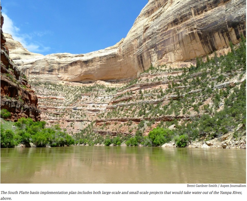
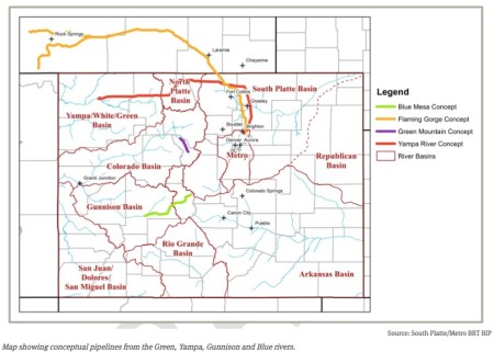
    At the core of the South Platte plan are potential new transmountain diversion or pumpback projects on the Green, Gunnison, Yampa, Colorado, Blue and Eagle rivers.

    The plan also highlights conceptual dam projects on the main stem of the Colorado River west of Rifle and at Wolcott, which would store water pumped up from the Eagle River.

    “Investigating, preserving and developing additional supplies from the Colorado River Basin is critical to effectively plan for future water supplies,” states the “South Platte Basin Implementation Plan.”

    The dry-up of “hundreds of thousands of acres of agricultural land” is “the default option if decision makers do not exercise the political will to preserve and promote opportunities to develop Colorado River Basin supply for use along the urban Front Range,” the plan says.

    The South Platte plan was prepared by consultants at HDR Engineering and West Sage working under guidance from the members of the South Platte and Metro roundtables. It was submitted to the CWCB in mid-April, as were seven other basin implementation plans from other roundtables.

    The South Platte and Metro roundtables include representatives from Denver Water, Aurora Water, Northern Water, the South Metro Water Supply Authority, Weld County, Arapahoe County, and the cities of Thornton, Greeley and Loveland, among many other entities.

    Water providers in the South Platte River basin now import 400,000 acre-feet of water from the Colorado River basin and another 100,000 acre feet from the Arkansas, North Platte and Laramie river basins.

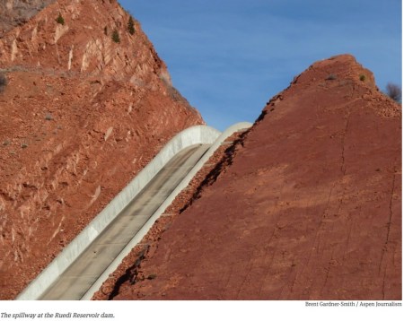
    By comparison, Ruedi Reservoir holds about 100,000 acre-feet of water.

    And Front Range water providers see the need for another 195,000 acre feet of water for growing cities and 260,000 acre feet more for irrigation, even though the amount of irrigated land is expected to shrink from 831,000 acres to 635,000 acres.

    The South Platte plan calls for minimizing the amount of “buy and dry” occurring on the Front Range by increasing the amount of new water supplies from the variety of rivers that make up the Colorado River basin within the state of Colorado.

    “Agricultural water transfers can be reduced if other solutions including the development of Colorado River supplies are more successful,” the plan states.

    It’s a concept found throughout the South Platte plan – the more Western Slope water made available to the Front Range, the less ag land will be dried up by expanding cities.

    “The South Platte and Metro Roundtables have expressed in many documents and venues that all the available options for water supply development must be pursued simultaneously not sequentially,” the plan says under the heading of “potential future actions.”

    “This approach can provide the greatest assuredness that Colorado River Basin water supply may be available for use, thereby reducing the need for East Slope providers to implement large-scale traditional agricultural to water urban water transfers,” the plans also says.

    conceptualtransmountaindiversionssouthplattebasinimplementationplan

    Large-scale concepts

    The South Platte plan identifies a range of projects that could deliver new Colorado River water supply to the Front Range and divides them into “large-scale concepts” and “smaller-scale and incremental concepts.”

    Under large-scale concepts, there are four “Colorado River transbasin concepts” listed in the plan, and they are on the Gunnison, Green, Yampa and Blue rivers.

    The projects have likely all been studied and described in the past in various documents, but they are only briefly described in the South Platte plan.

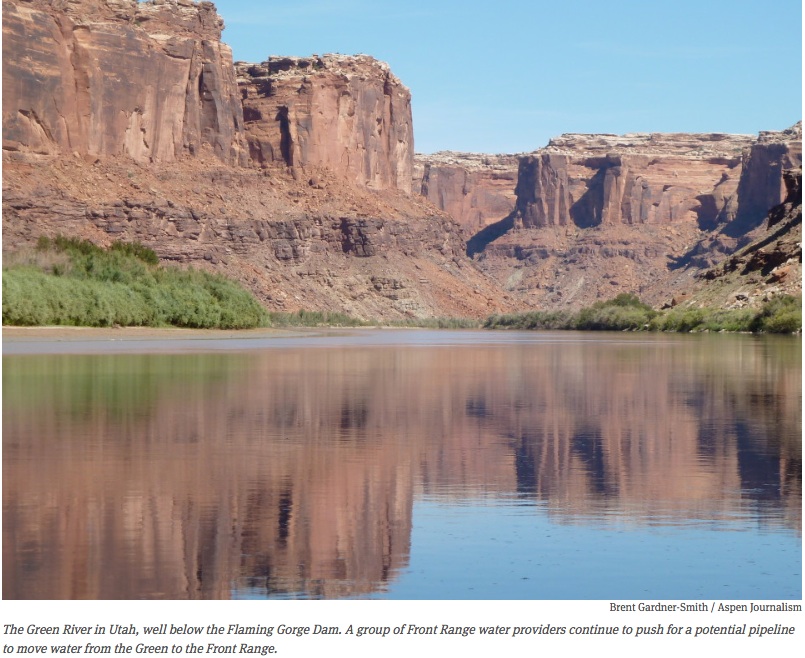
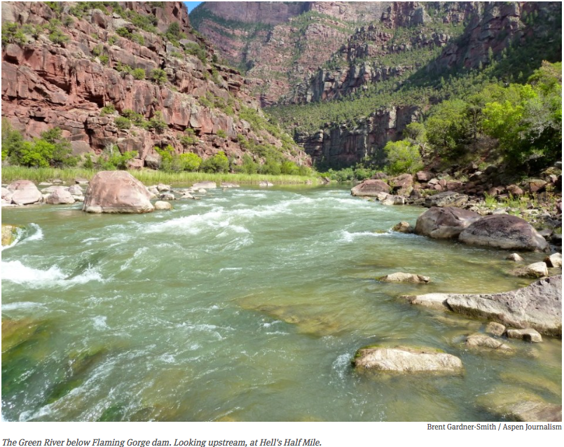
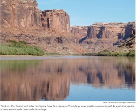
    A potential pipeline from Flaming Gorge Reservoir on the Green River to the Front Range is more fully explored than others, however, in both the main plan and in Appendix F.

    The Flaming Gorge pipeline concept has also been studied in-depth by the South Metro Water Supply Authority, which represents 14 water providers in Arapahoe and Douglas counties.

    All four of the “large-scale” projects would require new water storage facilities, including, perhaps, underground aquifers on the East Slope.

    The Flaming Gorge project involves contracting with the Bureau of Reclamation for 150,000 acre-feet of water from Flaming Gorge Reservoir. It requires a 355-to-442 mile pipeline and pumps to move water 1,400 feet to 3,100 feet up and over the Continental Divide to the Front Range.

    “Diversions would likely vary significantly from year-to-year depending on many factors potentially including hydrologic conditions, current storage levels in federal reservoirs (Colorado River Storage Project and Lake Mead), status of compact compliance monitoring, environmental and recreational needs and management strategies as well as Front Range water demands and storage levels,” the South Platte plan says of the Flaming Gorge pipeline.

    The South Platte plan also says that Flaming Gorge concept was put forward by the South Metro Water Supply Authority, which “stressed that the concept is now worthy of serious consideration” and “recommends further investigation as a practical and viable means to manage Colorado’s statewide water resources and that the concept be vigorously pursued in subsequent stages of the developing Colorado’s Water Plan.”

    The Blue Mesa Reservoir project also would require a water contract with Reclamation, in this case to move water from the Gunnison River through an 81-mile pipeline into the Arkansas River basin, from where the water would then be pumped into the South Platte basin. This requires pumping the water 3,400 feet in elevation.

    The Yampa River project would require a 250-mile pipeline and the need to pump water up 5,000 feet in elevation over at least two mountain passes. The project would divert or pump water out of the Yampa near Maybell into a large reservoir.

    The South Platte basin implementation plan says that with “large-scale” projects, there may be ways “to help offset the regional impacts of the projects, maximize and distribute statewide benefits, and ensure continued viability of the West Slope’s economy.”

    Or, in other words, provide benefits to the West Slope river basins where the water originates.

    For example, in turn for taking water out of the Yampa and White rivers, the South Platte plan finds that more infrastructure could be built as part of the transmountain water project to irrigate more land in Moffat Count, and provide more water to Steamboat Springs.

    In the Gunnison basin, a new transmountain project could create more storage in the upper Gunnison River basin and help with water quality problems in the lower Gunnison basin.

    The South Platte plan also notes that by building new transmountain diversion projects on the Gunnison, Yampa or Green rivers, it might be possible to leave move water in the already seriously depleted headwaters of the Colorado River.

    coloradoriveratutahstatelineaspenjournalism

    Smaller-scale concepts

    The plan also identifies a series of smaller-scale projects, including ways to leave more water in Green Mountain Reservoir – on the Blue River in Summit County – for eventual use by the Front Range.

    The Wolcott Reservoir would be perched on a cliff above the hamlet of Wolcott, where traffic destined for Steamboat Springs leaves I-70.

    It would be an “off-channel” dam and reservoir that would store water pumped uphill from the Eagle River.

    Once in a new Wolcott Reservoir, the water could be released downstream – which would free up water in Green Mountain Reservoir for Front Range use – or pumped up over Vail Pass and into the Front Range’s existing water diversion systems.

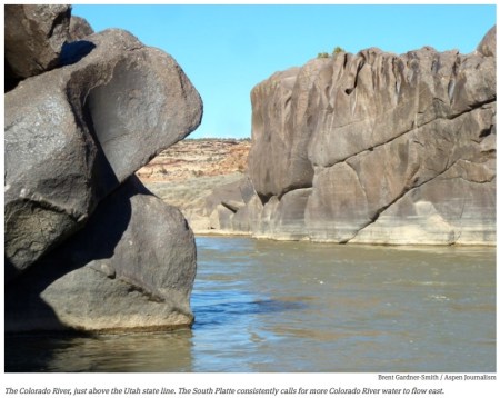
    The South Platte plan also describes a pumpback system that could be installed on the Colorado River below its confluence with the Gunnison River in Grand Junction.

    Otherwise free-flowing water, destined for Lake Powell, would be pumped from below the confluence back upstream 16 miles so it could either be diverted into the Government Highline Canal.

    Or it could be sent back downstream to help a regularly de-watered section of river below the canal, where native fish species are struggling to survive.

    In satisfying the senior water rights on the Highline Canal, and helping to keep fish alive – and the federal government at bay – the lower Colorado River pumpback project could also let water stored in Green Mountain and Ruedi reservoirs be used for other purposes.

    “A pumpback project on this stretch could provide water for the senior calling rights, therefore reducing the amount of Green Mountain Reservoir water that would need to be released for West Slope beneficiaries,” the South Platte plan notes.

    The Webster Hill Reservoir is described in the plan. It’s a dam and reservoir on the main stem of the Colorado River downstream from the city of Rifle where the river bends away from I-70.

    “This concept would include a regulating reservoir on the mainstem of the Colorado River with a volume of 30,000 to 40,000 acre feet,” the South Platte says.

    The plan also describes two potential “small-scale” projects on the Yampa River.

    One is called the “middle Yampa pumpback” and would take from a tributary of the Yampa, the Elk River, and send it through a tunnel under the Continental Divide and the Mt. Zirkel Wilderness Area to the headwaters of the Poudre River basin.

    A second is called the “mini Yampa pumpback,” which would take water from the headwaters of the Yampa, including Morrison and Service creeks, to Granby Reservoir and on to the Front Range.

    Then there is the Taylor Reservoir pumpback, which requires pumping water from Blue Mesa Reservoir up to Taylor Reservoir, and then sending it under the Continental Divide.

    “The water court has previously stated that the yield from this concept would be around 50,000 to 60,000 acre feet,” the South Platte plan notes.

    greenriveraspenjounalism

    Power and water

    The South Platte water-supply plan suggests that the South Platte basin is the most important, and powerful, part of Colorado.

    “Considering the various conversations with South Platte basin stakeholders, it seems that one of the key overarching messages that should be conveyed is that a good Colorado plan needs a good South Platte plan,” the plan itself proclaims.

    It also says, “Colorado lacks a cohesive plan to meet growing Front Range municipal water needs.”

    Today, 80 percent of the state’s population lives in the South Platte River basin, which includes the Front Range cities of Aurora, Denver, Boulder and Fort Collins, and many other smaller, but steadily growing cities. Population in the basin, now 3.5 million, is expected to climb to six million by 2050.

    According to the South Platte plan, “the single biggest driver of the need for additional water supplies is population growth” and the future water-supply gap in the South Platte basin accounts for 75 percent of the state’s forecasted water gap.

    And yet today “agriculture is the dominant water use in the basin, accounting for 85 percent of total water diversions.”

    The plan also sounds a “one Colorado” theme.

    “There are many factors that support a broad statewide approach to solving South Platte basin water supply issues,” the plan says, including that “regional affiliations are increasingly fluid with offspring of West Slope residents increasingly finding employment and raising families in new South Platte river basin communities.”

    spillwayatruediaspenjournalism

    Uphill to money

    The South Platte plan includes, as Appendix F, a “concept for discussion” put forward by the South Metro Water Supply Authority, which includes a review of how to compensate the Western Slope for the loss of its water.

    The Authority’s concept paper finds that “generally, the most useful form of compensation would be unrestricted monetary compensation to be used by the West Slope to compensate unprotected parties and for whatever other purposes its citizenry prefers.”

    Rather than committing a certain amount of money for specific projects, the South Platte plan appendix suggests “a development fund” be established “for future water needs or other economic development on the West Slope.”

    Front Range money could also be used, the appendix suggests, to try and repair the environmental damage already caused to headwater streams of the Colorado River by Front Range diversions.

    Which as the plan put it, could serve as “an early milestone in the process, bringing environmental benefits to the headwaters on the way to project permitting.”

    And the paper suggests that the “primary base of funding” for any new transmountain diversion would be “use rates and tap fees,” as “this connects the customers with what they are paying for.”

    Two other funding mechanisms are also explored, including a “water” mill levy in nine Front Range counties or a statewide “container fee” on beverage containers, both of which the plan says could generate about $100 million annually for new water projects.

    In the analysis of the water mill levy, or property tax, the plan suggests that half of the $107 million raised each year – $54 million – could pay for a new water project and the other half “could help provide water and economic development for the West Slope.”

    The plan also notes, as a “point of comparison,” that Gunnison County in 2009 only saw $10 million in general fund revenue.

    Finding such funding, and building a new transmountain diversion, would mean, according to the South Platte plan, that “transfers of East Slope agriculture would no longer be the dominant strategy for meeting Front Range water needs.”

    greenriverbelowflaminggorgeaspenjournalism

    A state water project?

    However, the plan notes that there are “some important factors affect our ability to implement large statewide projects.

    “First, smaller water providers on the Front Range, who will likely bear the largest part of the municipal and industrial gap, do not necessarily have the capability to develop new Colorado River Basin supplies on their own and will likely rely on conservation, reuse, and incremental agricultural transfers leading to a large loss of irrigated land in the South Platte Basin.

    “Secondly, it cannot be assumed that cities or private investors will be able to build the Colorado River Basin supply projects needed to avoid a large loss of South Platte agriculture.

    “A point has been reached in our state’s development where a state water project needs to be considered in order to minimize impacts of buy-and-dry,” the plan states. “This is the essential trade-off that Colorado’s Water Plan must recognize and address.”

    Editor’s note: Aspen Journalism is collaborating with The Aspen Times and the Glenwood Springs Post Independent on coverage of rivers and water. The Times published this story online on Tuesday, July 7, 2015.

    Take Two of Colorado’s Water Plan Released — KUNC #COWaterPlan

    Colorado transmountain diversions via the State Engineer's office
    Colorado transmountain diversions via the State Engineer’s office

    From KUNC (Stephanie Paige Ogburn):

    Over the course of the process, the state’s nine roundtables, representing eight different water basins (the Metro and South Platte roundtables are in the same basin), have outlined their ideas for state water use. As usual, the Front Range water districts are calling for more water from the Western Slope, with predictable outcry from those on the west side of the mountains.

    It’s the failure to make firm decisions on this sort of contentious issue that has led to criticism of the plan, which does not have binding authority and has not required participants to iron out where future water will come from.

    The participants in the process acknowledge the document lacks teeth, but Joe Frank, chair of the South Platte Basin Roundtable, said that’s deliberate.

    “It is a planning document, it’s not a law, it’s not a mandate, but these are more recommendations that hopefully people can actually follow up on and really start to do some real things,” said Frank.

    Yet those outside the process, including famed water expert Pat Mulroy — who led the desert city of Las Vegas’ water planning for decades, spurring the city to unprecedented levels of conservation while also shoring up its water supplies — told the Colorado Independent that a plan that doesn’t force anyone to make tough decisions isn’t much of a plan.

    The public can comment on the plan until Sept. 17, 2015. The final draft will be submitted to Governor Hickenlooper in December of the same year.

    More Colorado Water Plan coverage here.

    Colorado State University: Western Water Symposium & Barbecue, July 27

    westernwatersymposiumbarbecue07272015

    Click here to register.

    Colorado Water Institute and CWCB: Alternatives for ag/urban water uses studied

    Cache la Poudre River
    Cache la Poudre River

    From Colorado State University (Jim Beers):

    Can agriculture remain viable and urban water needs be met in one area of fast-growing Northern Colorado? A two-and-a-half year study, funded by the Colorado Water Conservation Board and facilitated by Colorado State University’s Colorado Water Institute, says maybe, but there are no easy answers.

    The Poudre Water Sharing (PWS) group, made up of representatives from Cache la Poudre River basin irrigation companies and the city utilities and special districts that provide municipal and industrial water from the Poudre, advised the research team as it collected data, surveyed irrigation company shareholders, and developed descriptions and prototype agreements for alternative water transfer methods that might work in the Poudre basin.

    What they learned

    In the end, the group issued a report at the end of June that details why they tackled the question, what they learned and their recommendations for the future.

    “The most important outcome of the work is that solid relationships were built among folks from the irrigation companies and those who manage Poudre basin water for domestic uses — relationships that can be called on for future problem solving,” said MaryLou Smith with the Colorado Water Institute, part of CSU’s Office of Engagement.

    The Colorado Water Conservation Board supported the study as part of the state’s effort to find ways to avoid “buy and dry,” the permanent removal of water from agriculture use. Avoiding the practice is a goal stated in the most recent draft of the State Water Plan.

    “Overall, the people in our survey sample made it clear that they want something done to address lands being purchased by entities outside of the watershed and the water moved elsewhere,” said Alan Bright, associate professor in CSU’s Department of Human Dimensions of Natural Resources, who conducted the survey of stakeholders. “They want the water kept in agriculture, but they may not always agree with one another about the best ways to do that.”

    ‘Buy-and-supply’ alternative?

    The need for more urban water has placed a bull’s eye on the Poudre’s agricultural water, but there is a certain amount of hesitancy about entering into water sharing agreements at this point.

    “While farmers want to see water stay in agriculture, they also want to be sure nothing jeopardizes their right to sell their water. While domestic water providers understand the many benefits irrigated agriculture brings to the area, they don’t want to restrict their ability to provide a reliable source of water for their future customers,” said Andy Jones of the law firm Lawrence, Jones, Custer and Grasmick, a member of the research team.

    A “buy-and-supply” concept surfaced late in the group’s discussions, and gained the interest of others outside the group, such as open space managers and conservation groups. The concept involves creating an entity with public/private money that would buy agricultural land and water at full market value from farmers wanting to sell. The entity would put an easement on the land and water, and lease most of it back to those who want to keep farming, keeping the water in agriculture; a certain portion of the water would be leased for urban use. While PWS members were split on their support for the concept, there was a moderate level of interest among irrigation company shareholders, making it an idea worth pursuing.

    “Buy-and-supply is an innovative concept that could include discussions surrounding open space, wildlife habitat, and other quality of life benefits agriculture provides,” said George Wallace, a PWS member who farms near Wellington and is a representative of the Larimer County Agricultural Advisory Board. “Agriculture brings so much more to the region than immediately meets the eye, amenities that will be sorely missed if we don’t move to keep water in agriculture.”

    Next steps

    The work started by the PWS will continue this fall as a newly adopted initiative of the Poudre Runs Through it Study/Action Work Group, which will broaden the number of interested parties to include environmental, business, and recreational stakeholders along the Poudre River from Fort Collins, Timnath, Windsor and Greeley. The hope is to better understand the feasibility of ag/urban water sharing arrangements in the Poudre Basin that could result in keeping agriculture viable even as the population in the region grows.

    There’s more information on the Poudre Water Sharing group’s study here.

    More Cache la Poudre watershed coverage here.

    Settlement calms the waters — The Pueblo Chieftain

    Southern Delivery System route map -- Graphic / Reclamation
    Southern Delivery System route map — Graphic / Reclamation

    From The Pueblo Chieftain (Chris Woodka):

    Colorado Springs Utilities will have an easier time meeting conditions of its 1041 permit for the Southern Delivery System with Pueblo County as a result of a settlement agreement with Walker Ranches.

    The $7.1 million settlement reached June 16 includes $5.78 million to pay a $4.75 million judgment awarded by a Pueblo jury in May plus interest dating back to 2011. Another $1.34 million covers the court costs and expenses incurred by Walker Ranches.

    But the agreement does much more.

    Pueblo County commissioners are making plans for a compliance hearing later this year on several conditions included in the 1041 permit, including Colorado Springs’ promises to revegetate the entire route of the SDS pipeline through Pueblo County and the provision that landowners would not pay out-of-pocket expenses.

    But any issues concerning Walker Ranches are resolved, according to the settlement.

    The Pueblo Chieftain obtained a copy of the confidential settlement agreement through a Colorado Open Records Act request after the document was alluded to at the June 26 meeting of the Fountain Creek Watershed Flood Control and Greenway District.

    The agreement blocks Gary Walker, principal owner of the ranches, and Utilities from discussing its contents without mutual consent.

    Walker had been vocal about damage to the ranchland before and after the jury trial.

    The agreement specifies three conditions and accompanying mitigation appendices in the 1041 permit that pre-empt any complaints about compliance from Walker Ranches.

    It still leaves open the question of Pueblo County determination of compliance regarding revegetation.

    In return, Colorado Springs will address several of Walker’s concerns which it fought in court.

    Those include fencing off the area being revegetated, paying Walker $300 per acre annually for the area that is being fenced, working with Walker on improving drainage and modifying the language in its easement if it interferes with future conservation easements.

    Future construction activities on the easement are to be addressed separately, according to the settlement.

    In addition to revegetation questions, the county is looking at whether Colorado Springs is complying with its commitment to control stormwater.

    Colorado Springs Mayor John Suthers and City Council President Merv Bennett outlined plans for stormwater funding to Pueblo City Council this week. Suthers also has met individually with Commissioners Liane “Buffie” McFadyen, Terry Hart and Sal Pace.

    Colorado Springs wants to include Pueblo County and other entities in a stormwater agreement that would provide input about whether stormwater improvements benefit Pueblo. Stormwater control is important because of the increased base flow in Fountain Creek as a result of more water coming through the SDS pipeline.

    More Southern Delivery System coverage here

    Lake Pueblo returning to normal as floodwater released — The Pueblo Chieftain

    Pueblo Dam
    Pueblo Dam

    From The Pueblo Chieftain (Chris Woodka):

    Maybe it’s time to slap a tag on the Arkansas River that says “shrinks when wet.”

    Despite a rainy week, the flow in the Arkansas River is expected to be cut in half today, as the last of stored floodwater is released from Pueblo Dam.

    “We started to cut the flows (Tuesday) afternoon,” said Roy Vaughan of the Bureau of Reclamation. “They should be around 2,500 (cubic feet per second) in the morning.”

    Water levels have allowed most areas of Lake Pueblo to be reopened, although the sailboard area parking lot still is being assessed and some shoreline areas are soft, Lake Pueblo State Park Manager Monique Mullis said.

    “There are still some logs in the water,” Mullis said.

    The park is planning to announce wood collection opportunities in the near future.

    After the water levels drop in the Arkansas River, Colorado Parks and Wildlife, the city of Pueblo and Pueblo County will decide on whether to lift boating restrictions that remain in effect on the river to the Otero County line.

    Wet weather returned to the Pueblo area this week, with storms leaving up to half an inch of rain in Pueblo Monday, an inch in areas west of Pueblo and up to 3 inches in the Beulah and Colorado City-Rye areas.

    Similar rainfall totals were expected through Tuesday night, with even heavier rain expected today, according to Randy Gray of the National Weather Service in Pueblo.

    “The heaviest precipitation should be in the mountain areas in the Sangre de Cristo (Range), Wet Mountains, El Paso and Teller counties,” Gray said. “It should move to the east by Thursday.”

    Up to an inch of rain is expected in the Upper Arkansas Valley and the northern San Luis Valley.

    The new rain kept water levels on Fountain Creek and in the Arkansas River high. Avondale briefly reached flood stage for the first time in a week Tuesday morning, but should return to lower levels as Pueblo Dam releases are cut.

    Fountain Creek levels jumped slightly Tuesday, but were nowhere near the damaging levels in May and June.

    The rain had not caused any new damage to county roads, although some private driveways washed out in the Rye area, said Alf Randall, Pueblo County public works director.

    Fountain Creek continues to cut at Overton Road north of the Pinon Bridge, and negotiations with Pueblo Springs Ranch owners for a byoff pass route continue. The county this week began work on shoring up the northwest dike on the Pinon Bridge to prevent damage, Randall added.

    More Fryingpan-Arkansas Project coverage here.

    IBCC: July 2015 Second Draft of Colorado’s Water Plan teleased #COWaterPlan

    Colorado Water Plan website screen shot November 1, 2013
    Colorado Water Plan website screen shot November 1, 2013

    Click here to download the plan. Don’t forget to get involved.

    More Colorado Water Plan coverage here.