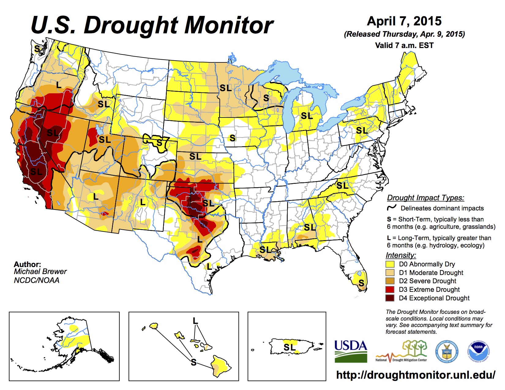
Click here to go to the US Drought Monitor website. Here’s an excerpt:
Summary
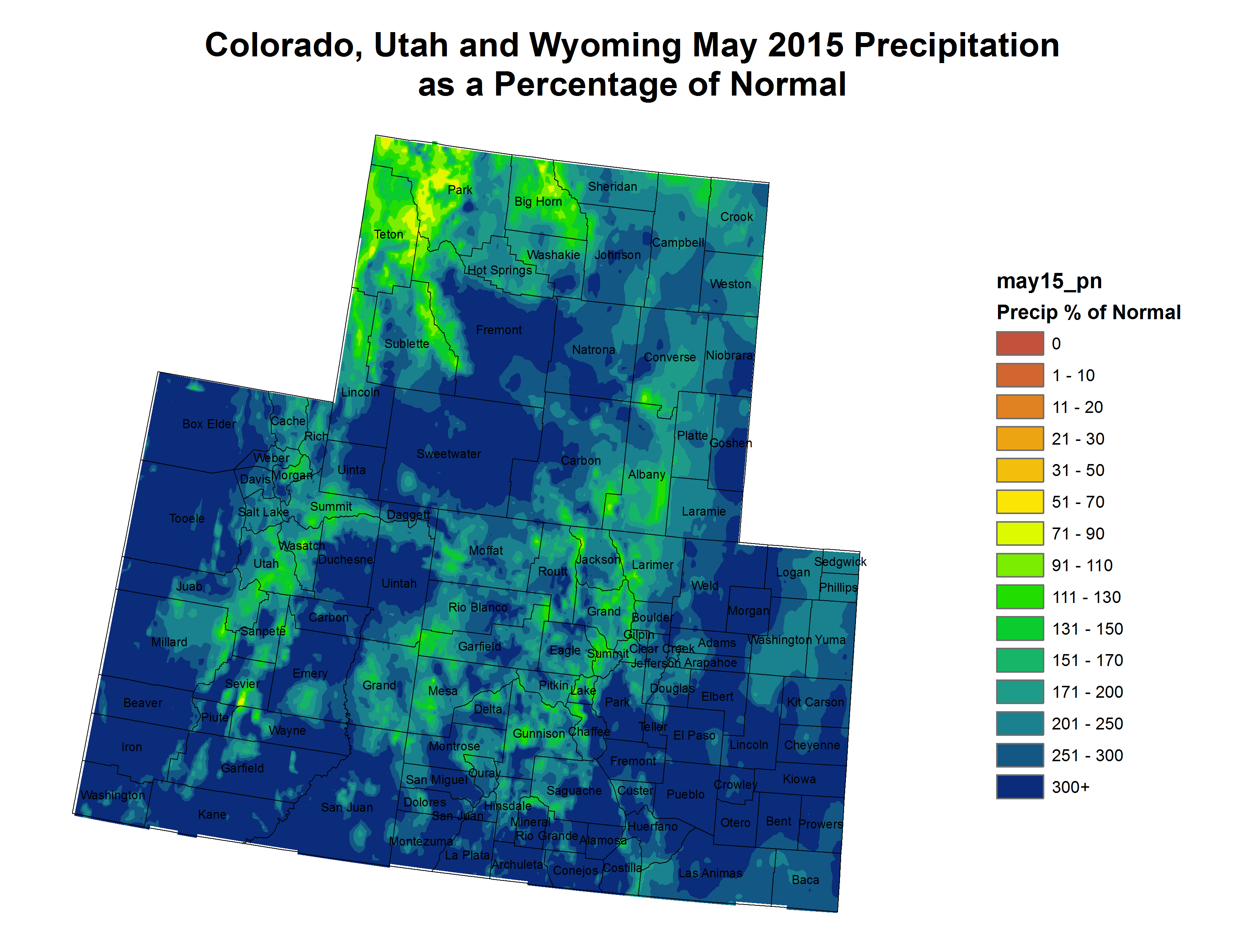
This U.S. Drought Monitor week saw improvements in the Southwest as overall conditions continued to improve across parts of the region. Improvements primarily were focused upon west-central New Mexico and northern Arizona where most long- and short-term indicators have pointed toward improvements, although reservoir storage levels in various drainage basins remain below normal. During the weekend, residual moisture associated with Hurricane Dolores fueled showers and thunderstorms across southwestern California and western Arizona leading to locally heavy rainfall accumulations and flash flooding. Despite well-above-average precipitation in southern California during the past 90 days, recent rainfall has had little impact on the overall drought situation in the state. In the Pacific Northwest, above average temperatures and precipitation deficits continue to mount across the region with growing concern about potential crop losses in central and eastern Washington. Moving eastward, short-term precipitation deficits led to slight deterioration of conditions in the northern Plains while locally heavy rainfall was observed across drought-free areas of Illinois, Indiana, Ohio, Kentucky, and Missouri. In the Southeast, conditions continued to deteriorate across portions of Alabama, Georgia, and South Carolina where excessive heat and lack of rainfall dried soils and reduced streamflows. According to the National Centers for Environmental Information (NCEI) climatological rankings, the contiguous U.S. average temperature for June was the second hottest in the observational record (1895–2015). On a state level, California, Idaho, Oregon, Utah, and Washington all experienced their hottest average-temperature Junes on record since 1895…
The Plains
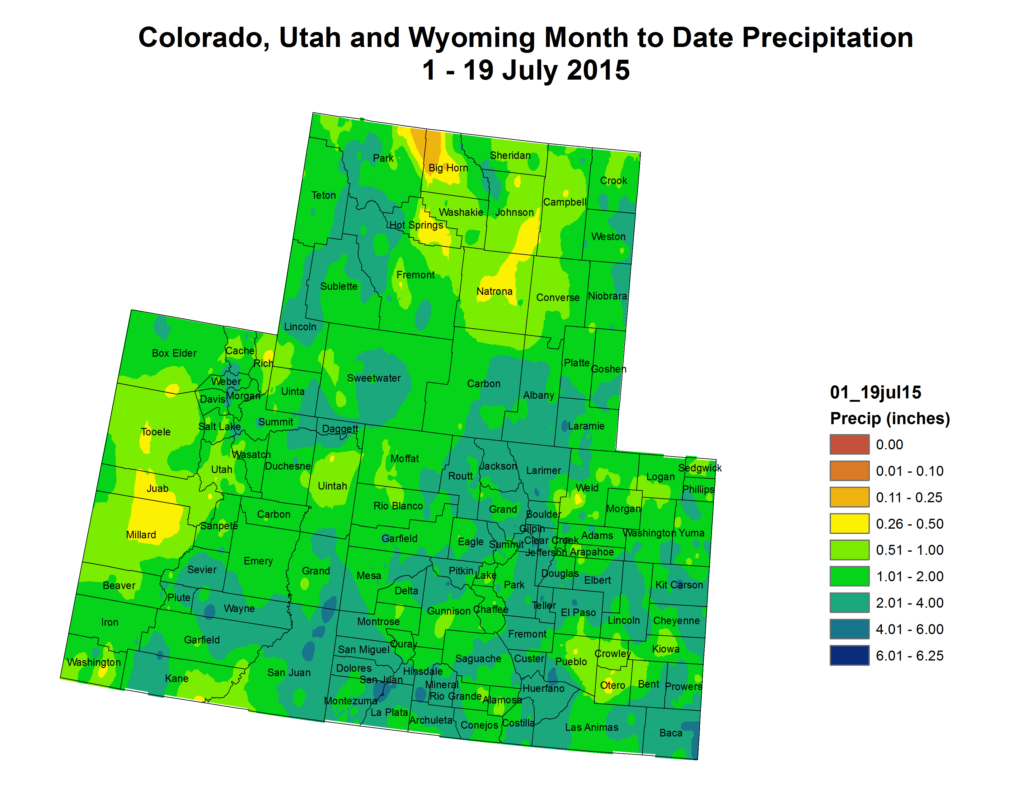
Across the central and northern Plains, temperatures were near normal in eastern portions while western parts were below normal. In the southern Plains, temperatures were near- to-slightly-above normal for the week. The heaviest rainfall accumulations (two-to-four inches) were observed in isolated pockets of northwestern Kansas and the Oklahoma Panhandle, while lesser amounts (one-to-three inches) were recorded in the central and northern Plains. On the map, areas of Abnormally Dry (D0) expanded in Kansas, North Dakota, and South Dakota where short-term precipitation deficits exist…
The West
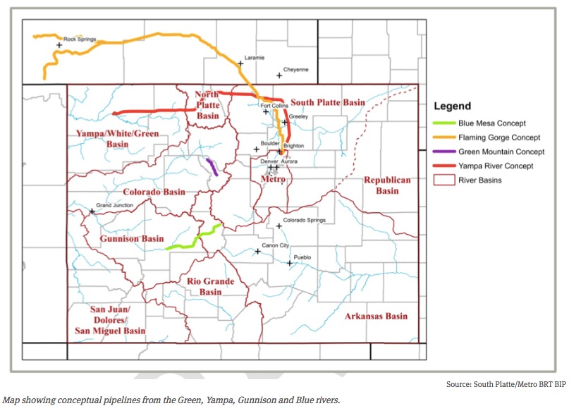
During the past week, average temperatures were below normal across much of the West with the exception of western portions of California and Oregon, eastern New Mexico, and Washington. During the weekend and into Monday, moisture associated with Hurricane Dolores triggered showers and thunderstorms across parts of southern California and western Arizona. Some locally heavy accumulations (two-to-four inches) and flash flooding were reported. Despite well-above-average precipitation during the past 90-days in parts of central and southern California, the Sierras, and portions of the Great Basin, the recent rains have not impacted the overall drought situation in these areas because significant precipitation deficits remain as well as agricultural and hydrological (low reservoirs, below normal streamflows) impacts. In the Pacific Northwest, precipitation has been below normal since the beginning of the Water-Year (Oct. 1). The trend has continued during the past 60-days leading to very low streamflows, dry soils, and increasing concern in the agricultural sector. In the Southwest, some improvements were made on this week’s map in areas of Severe Drought (D2) in west-central New Mexico as well as east-central and northern Arizona where long- and short-term drought indicators (precipitation, soil moisture, streamflows, and vegetative health) have shown improvement during the past year. However, according to the Natural Resource Conservation Service (NRCS), statewide reservoir storage remains below normal in both Arizona and New Mexico. According to the Salt River Project (SPR), the Salt River system reservoirs are currently 53% full while the Verde River system reservoirs are 52% full. In New Mexico, Elephant Butte (the state’s largest reservoir on the Rio Grande) is currently 27% of average – up 9% from the same time last year. Elsewhere, statewide reservoir storage is above average in Colorado, Idaho, Montana, and Wyoming…
Looking Ahead
The NWS WPC 7-Day Quantitative Precipitation Forecast (QPF) calls for generally dry conditions across most of the western U.S. with the exception of some modest accumulation (one-to-two inches) in northern portions of the Great Basin, northern Rockies, and North Cascades. In contrast, the central and northern Plains and western portions of the Midwest are forecasted to receive one-to-three inches while heavy precipitation is forecasted in southern Georgia and Florida with totals in the three-to-seven inch range. The CPC 6–10 day outlooks call for a high probability of above-normal temperatures east of the Rockies as well as along the West Coast while most of the interior West will be below normal. Across the West (with the exception of extreme southeastern Arizona and southwestern New Mexico), there’s a high probability of below-normal precipitation while the central and northern Plains, western portions of the Midwest, Northeast, and Southeast have a high probability of above-average precipitation.