New-found attention to #AnimasRiver health called ‘silver lining’

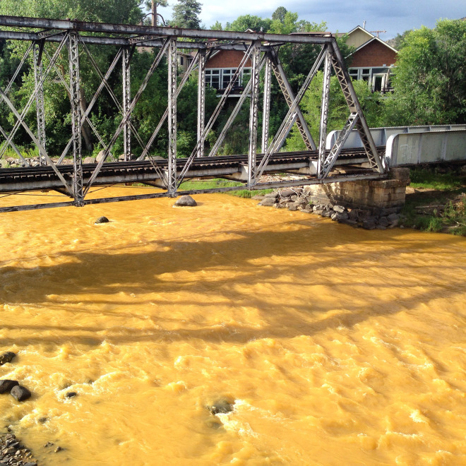
A “get well soon” balloon floats in the contaminated waters of the Animas River flowing through Durango on Monday afternoon August 10, 2015 -- photo The Durango Herald, Shane Benjamin
A “get well soon” balloon floats in the contaminated waters of the Animas River flowing through Durango on Monday afternoon August 10, 2015 — photo The Durango Herald, Shane Benjamin

From The Durango Herald (Jonathan Romeo):

Not wanting to let attention waiver on the need to improve water quality in the Animas River watershed, key stakeholders on Sunday held an informational open house at the La Plata County Fairgrounds.

“If there is a silver lining, it’s that now there is all this awareness concerning the health of the river,” said Ann Oliver of the Animas Watershed Partnership.

Oliver’s concentration has been monitoring the lower Animas, near the Colorado-New Mexico border. There, she told interested participants that the water is less affected by acid mine drainage. Instead, high levels of E. coli and other potentially dangerous nutrients pollute the river.

“It’s not as visible an issue,” she said. “It doesn’t color the water. It’s not coming from a specific point source. So it’s hard to say, ‘Let’s fix this.’ But it’s an issue we need to keep working on.”

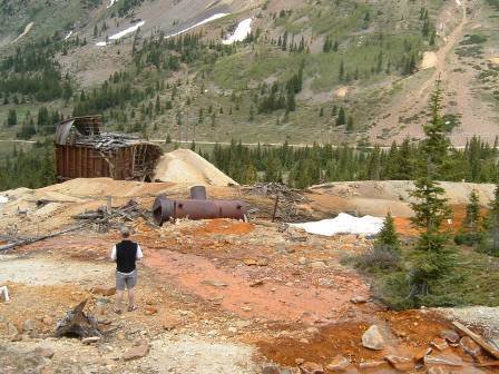
Priscilla Sherman has been in Durango full-time for eight years, but has lived in and around the area since 1972. She was well-aware of mine contamination before the Aug. 5 Gold King Mine blowout.

“I used to hike all around Silverton, and for years wondered what the heck was coming out,” she said. “I’ve been very interested in the health and future of the Animas River, and I’ve become more knowledgeable with real facts. I’m really happy to see there continues to be a movement to be proactive in the cleanup.”

A major step in that direction is the push from the San Juan Clean Water Coalition to provide stronger legal protection for local groups that look to address mine drainage, known as the good Samaritan law.

“The question now is what to do post-spill,” said Ty Churchwell, a campaign coordinator for the coalition and coordinator for Trout Unlimited. He added that a good Samaritan law would offer an alternative to a Superfund listing.

However, Kristine Johnson, a member of the Great Old Broads for Wilderness, took her Sunday afternoon to seek answers why stakeholders are opposed to the Environmental Protection Agency’s hazardous cleanup program.

“I’d like to know who are all the members (of the Animas River Stakeholders Group) and why they’re so reluctant to do Superfund,” Johnson said. “I realized two years ago the Stakeholders’ mission was to stave off Superfund, and it’s very unclear why.”
Babbitt says conservation starts with conversation at local level — The Durango Herald

From The Durango Herald (Jonathan Romeo):

Bruce Babbitt is a former governor of Arizona who served as secretary of the Interior from 1993 to 2001 under President Bill Clinton. Since, Babbitt has become a vocal proponent of protecting significant landscapes in the West and is a board member of Conservation Lands Foundation. On Tuesday, he sat down with The Durango Herald…

Q: In 2013, you were critical of President Barack Obama’s conservation work. Has that changed in recent years as he finishes out his final term?

A: It has changed enormously. The president, to his credit, has awakened to Western land conservation. He is doing an excellent job. The area we’re concerned about, national monuments, protecting (Bureau of Land Management) land, he’s issued a series of remarkable proclamations all across the West.

Q: From your experience with past presidents, what do you think changed?

A: He has awakened. When a president is newly elected, they don’t campaign on these issues. They campaign on health care and foreign policy. There is a process of discovering these other issues in the course of a presidential term. Clinton was the same way. In that last term, a lot happened. I think that’s sort of a typical kind of route. Some of it surely is a president thinking about their legacy.

Q: What are your thoughts on Obama’s new greenhouse gas emission regulations, the Clean Power Plan?

A: It is the most important step forward. It is a really important step to deal with global warming.

Q: So you are on the record for believing in global warming? Do I have that correct?

A: Well, I don’t want to go too far in this interview.

Q: Do you think the current presidential debates give enough attention to the issue of land conservation?

A: No. It’s not being talked about enough. President Obama has begun a national discussion about climate change. I think it will show up in the national campaign. It’s such an overwhelming apocalyptic threat to our entire national future. I think it will be the debate.

Q: You’ve taken a hard stance on public resistance to federal management, such as the Clive Bundy standoff. Where do you think that resentment for the federal government in the West comes from?

A: There has always been in the West a certain kind of resentment of the federal government. It’s always been there. I come from a five-generation ranching family. When Teddy Roosevelt came to Arizona and said he was going to make a national monument around the Grand Canyon where my family ranched, my grandfather led the opposition.

And now, a few generations later, my relatives are all saying, “We were out there with Teddy when all these great things happened.” There’s just a kind of independence about Westerns on the land. We don’t want anybody from Washington here.

But it’s changing. Colorado has changed a great deal. There is real support for conservation. I was part of a couple monument proposals in Colorado, and they all had tremendous support. But Utah is still kind of like my family was in Arizona.

Q: In trying to preserve lands, how do you bridge that gap?

A: Start a discussion at the local level. Get everyone in. Talk, communicate, listen and try to isolate what the issues are. You have to get away from ideology and to a discussion out on the ground.

Q: What, in your opinion, are the major issues facing the West?

A: One is working with the BLM as an institution for conversation. The BLM is the biggest land agency of them all, and never had a strong conservation program.

Only in the last generation we have begun to open our eyes to the reality of the arid landscapes of the west, which are mostly BLM. We have finally begun to awaken to the importance of it, and that has to be worked on because government agencies respond to the people. That’s the reason local engagement is so important.

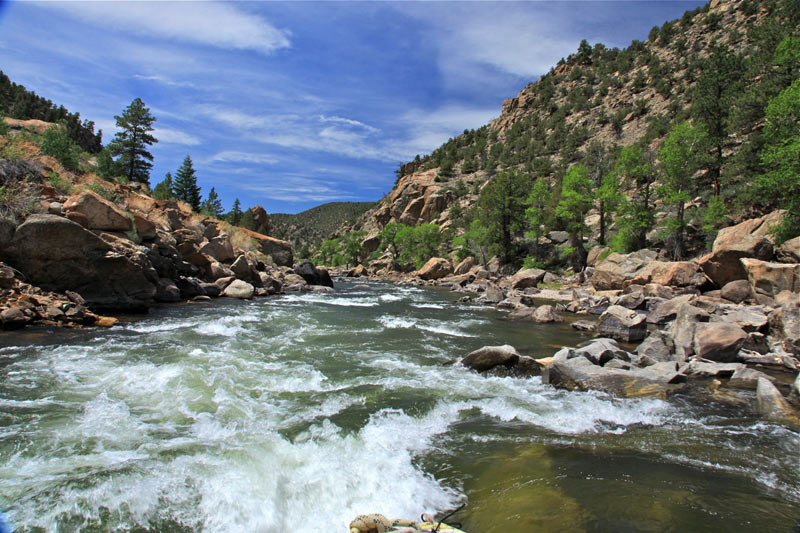
Browns Canyon via BrownsCanyon.org

Drainage district sends out notices of impending fees — The Grand Junction Daily Sentinel

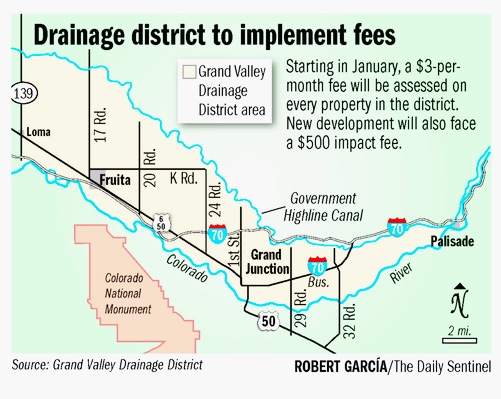
Grand Valley Drainage District boundaries -- Robert Garcia The Grand Junction Daily Sentinel
Grand Valley Drainage District boundaries — Robert Garcia The Grand Junction Daily Sentinel

From The Grand Junction Daily Sentinel (Gary Harmon):

Several thousand Mesa County businesses and governments received notices this week of the bills they will get in January from the Grand Valley Drainage District.

Many of them promptly put in calls to the Grand Junction Area Chamber of Commerce, which as it happens has scheduled a roundtable on Friday with the district about those very fees.

“It’s a job-killer,” chamber President Diane Schwenke said of the district’s plans.

Actually, said Tim Ryan, general manager for the district, the bills were tailored to be “palatable, but still generate revenue” the district needs to manage storm water.

While the chamber doesn’t question the need to control storm water filling the district’s pipes and ditches, the district’s plans for fees are an unnecessary damper on an already struggling local economy, Schwenke said.

While some businesses might be able to absorb the fees, for many others the costs will be significant, Schwenke said.

“They’re solving a problem by creating a problem,” Schwenke said.

The drainage district this summer put in motion plans to collect a $3-per-month base fee on the more than 44,000 tax parcels within its boundaries, and a $500-per-unit impact fee on new development. The $3 fee is based on parcels containing 2,500 square feet of impervious surface — which describes most of the affected residential parcels.

The fee schedule, however, makes no accommodation for large properties.

The biggest bill, for $14,000, will go to Halliburton, Ryan said, who noted that when the company received notification, it starting making arrangements for payment.

Many of the 100 most-substantial bills will go to companies with headquarters outside the county, so, “We’re actually bringing in outside money and hiring local people to do the construction,” Ryan said.

A major problem is that the $500 fee on new construction could damper business expansion, said Schwenke, who contends that the district should look at how other communities are collecting storm water fees.

The district’s fees, however, are minor in comparison with water, sewer and traffic fees, Ryan said.

It’s difficult to offer reduced fees to businesses or other entities with large, impervious surfaces, such as parking lots, because the size of the surfaces contributes to the runoff issues the district is trying to control, Ryan said.

The chamber is hosting a business roundtable from noon to 2 p.m. on Friday at Ute Water Conservancy District’s office, 2190 H 1/4 Road, to discuss the drainage district fees.

Get Involved: The Bureau Of Land Management’s Eastern Colorado Plan — Elevation Outdoors

From Elevation Outdoors (Kirsten Dobroth):

Currently, the Bureau of Land Management is drafting a plan to dictate how this land, and many other areas scattered throughout Eastern Colorado totaling 668,000 acres and 6.8 million acres of BLM managed mineral estate, will be used in the decades to come. As diverse as it is extensive, the area constituting this massive acreage stretches from Cañon City to Leadville, and encompasses plains as well as high alpine terrain. Land use plans take years to draft, and create a guideline for decisions about land use within the given area for at least twenty years. Land allocation decided in the drafting process for the Eastern Colorado Resource Management Plan, or the Eastern Colorado RMP, will create a guide for decisions about conservation, recreation, grazing, energy development, transmission lines, logging- pretty much anything the land could and would be used for. With a growing population, and many interested parties that include environmentalists, recreationalists, ranchers, miners, and the oil and gas industry, the Bureau of Land Management has the enormous task of creating a plan that falls within the framework of the law, while also meeting everyone’s needs.

The Process

However arduous this may seem, the drafting process for the BLM’s Eastern Colorado RMP isn’t shrouded in layers of bureaucracy as one might assume. In fact, the BLM is launching a new format for this process, dubbed Planning 2.0, which promotes transparency, and heavily depends on public involvement. Members of the Royal Gorge Field Office, which is in charge of the Resource Management Plan, explained that much of Planning 2.0 hinges on public input, and that because of the length and scale of the drafting process (land use plans typically take anywhere from 4-8 years to put together), they have organized both recreation focus groups and envisioning meetings with the purpose of asking participants, “What do you want from your public lands?” Resource Management Plan Project Lead, John Smeins, explained that the drafting process the BLM will be using for Eastern Colorado aims to keep the public in touch with BLM officials. “The new process of Planning 2.0 creates more of a conversation between us and the public. This land use plan really affects everyone, whether they know it or not, and we want to get everyone involved in creating it,” he said. In this sense, the revised land use drafting process seeks to decrease the time between plan revisions, and keep the comment period open as well.

Outside Influence

Other groups around Colorado are also using the drafting process as an opportunity to get the public engaged in decisions that will affect the land that many live and play on for years to come. Conservation Colorado and Wild Connections both have had a hand in getting people involved in the Eastern Colorado RMP discussion. John Sztukowski, of Wild Connections, has been involved with the project for over two years, and has helped to increase advocacy for land preservation by helping the BLM take inventory of land with wilderness characteristics. “It’s a huge project, and they’re really receptive to feedback,” he said. Sztukowksi helped make the case for nearly 250,000 acres of land with wilderness characteristics that is being considered in the drafting process from the BLM’s original inventory of 77,000 acres. “They [the BLM] often find discrepancies between current land use and previous inventory, and they appreciate outside input in the process of drawing up a plan for land use.” While the BLM will also have to accommodate for industrial use along with conservation, Sztukowksi hopes that much of the inventory he has mapped out will help preserve wildlife habitat and recreation outlets for future generations of Coloradans.

Conservation Colorado has similarly taken a proactive role in assisting the BLM with a public use plan that balances environmental protection with development and private use. Scott Braden, Conservation Colorado’s Wilderness Advocate and Policy Lead, explained the importance of public awareness and involvement in the drafting process for Eastern Colorado’s RMP as pivotal, as it guides land use in an area that is heavily trafficked by the Front Range for the next two decades. “The land in the Eastern Colorado RMP is pretty extensive as it goes from southeastern Colorado all the way up towards Leadville, and encompasses the Arkansas River headwaters. As more and more people from around the state use this land each year, it’s important to put together a plan that balances recreation, preservation, and more extractive uses,” he explained.

What do you want from your public lands?

The common thread between all of the parties involved in developing the Eastern Colorado Resource Management Plan is the importance and value of public input. Although the BLM has been proactive in organizing meetings for members of the public to have their voices heard over proposed land use, the numbers turning out for the meetings has oftentimes been disappointing. Scott Braden, of Conservation Colorado, similarly echoed the sentiment that many people who use the land avidly for recreation are unaware of the land use plan being drafted, even if it directly implicates land on which they regularly hunt, fish, or hike. While groups like Wild Connections has been organizing hikes to familiarize people with some of the areas this land use plan will affect, the biggest way to have an impact is to directly get in touch with the Bureau of Land Management.

“The purpose of restructuring the drafting process is to encourage more people to get involved with decisions about the future of their public lands, ” explained Kalem Lenard, the project’s Outdoor Recreation Planner, “This is a long term vision for a large area of Colorado, and public input is so important for us to create a vision that people are happy with.”

Get involved by contacting the Bureau of Land Management’s Royal Gorge Field Office.

blmeasterncoloradofieldofficemap

Reclamation Releases a Draft Environmental Assessment for Piping the Zanni Lateral of the Crawford Clipper Ditch

Here’s the release from Reclamation (Jenny Ward):

The Bureau of Reclamation announced today that it has released a draft environmental assessment on the Zanni Lateral of the Crawford Clipper Ditch located in Delta County, Colorado.

The project would replace approximately 1.7 miles of open irrigation ditch with buried water pipeline. The purpose of the project is to improve the efficiency of water delivery to canal users and reduce salinity loading in the Colorado River Basin.

The draft environmental assessment is available online at http://www.usbr.gov/uc/envdocs/index.html, or a copy can be received by contacting Jenny Ward at 970-248-0651 or jward@usbr.gov.

Reclamation will consider all comments received prior to preparing a final environmental assessment. Comments can be submitted by email to lmcwhirter@usbr.gov or by mailing Ed Warner, Area Manager, Bureau of Reclamation, 445 West Gunnison Ave, Suite 221, Grand Junction, CO 81501. Comments are due by Friday, December 11, 2015.

Gunnison River Basin via the Colorado Geological Survey

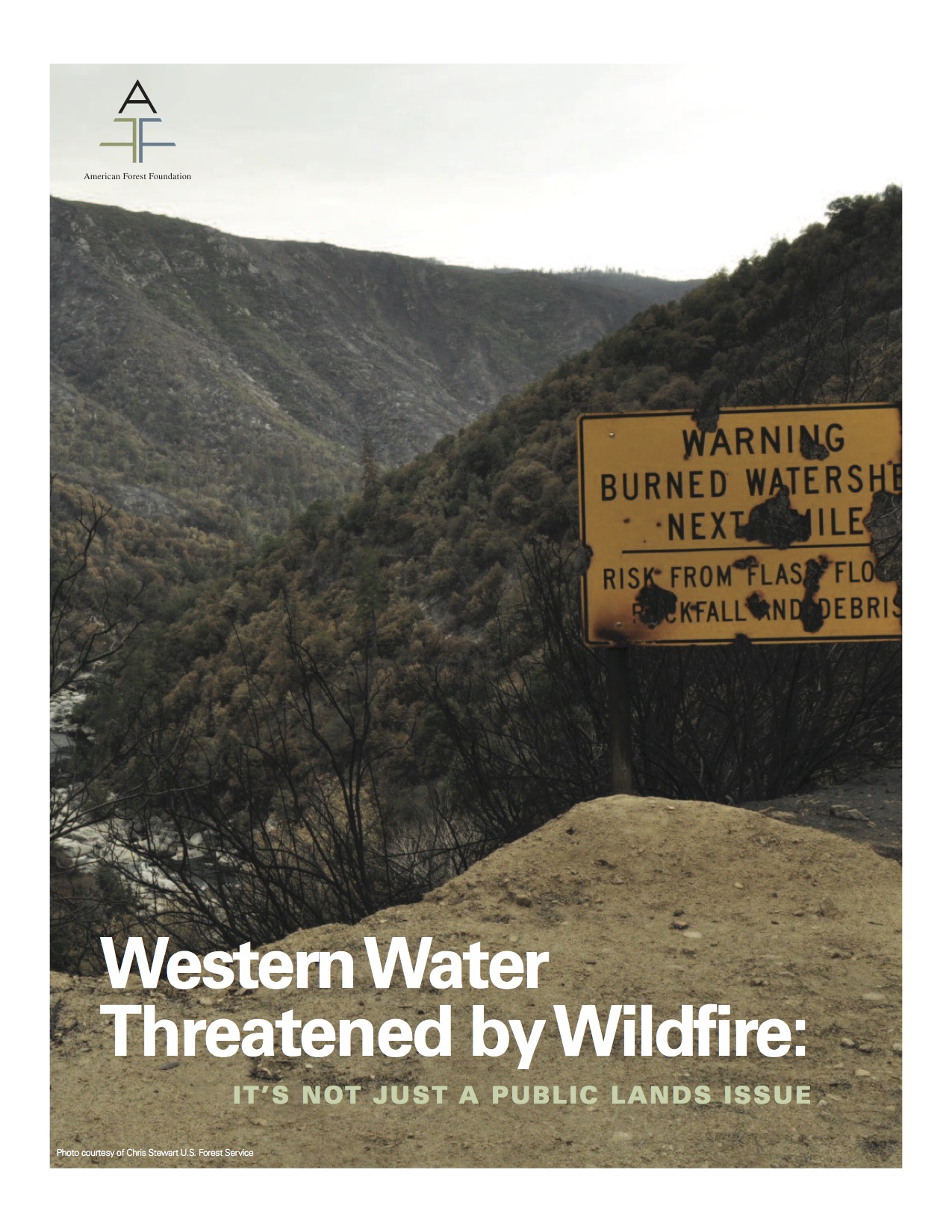
Report: Western Water Threatened by Wildfire — American Forest Foundation

finalfirereport112015americanforestfoundation

Click here to read the report. Click here to go the website.

Here’s the release from the American Forest Foundation:

Amid record drought and a record wildfire season in the West, the American Forest Foundation (AFF) today released a new report that reveals private and family landowners offer a solution to helping ensure that clean water in the West is protected from future catastrophic wildfires.

The report Western Water Threatened by Wildfire: It’s Not Just a Public Lands Issue, shows that across 11 Western states, 40 percent, or 13.5 million acres, of the forests and other lands that help protect clean water and that are at a high risk of catastrophic wildfire are private and family-owned.

In addition to revealing this new information, the report also includes findings from a West-wide survey of family landowners that show these landowners want to do the right thing and are motivated to take action that will reduce the risk of wildfire and help protect clean water in their forests. However, what prevents most, is the high cost of implementing management actions.

The report also includes a series of recommendations to help landowners overcome this obstacle, including increased engagement and outreach to private and family landowners to help provide both financial and technical help, policy solutions that fix how wildfire is budgeted for at the federal level and that encourage cross-boundary action, and increased market opportunities to utilize private sector strategies to reduce costs of management actions.

“The four-year drought, plus a record-breaking wildfire season has made protecting clean water an urgent and pressing problem in the West,” said Tom Martin, President and CEO of the American Forest Foundation. “Private and family landowners are ready to act and now, and we need to do everything possible to empower them to ensure that wildfires don’t hurt this limited resource that is vital to all Americans.”

Approximately 64 million Westerners depend on surface water that comes from forests and other lands for their clean drinking water. These lands store water, replenish streams and rivers, and filter pollutants from the water. When catastrophic wildfires burn these lands, they bake the ground, destroying this natural storage and filtration system and creating a hard-packed layer. This causes soil, debris and other pollutants to runoff during the next rain storm, which compromises water quality. Protecting this clean water supply requires action to reduce wildfire risks on public, private, and family lands.

“Today’s report underscores the urgent need for action to address the runaway growth of fire suppression costs, which continues to erode the Forest Service’s capacity to mobilize resources to reduce fire risk and restore the health and resiliency of the nation’s forests so that we can prevent fires in the first place,” USDA Under Secretary for Natural Resources and Environment Robert Bonnie said. “The most important step Congress can take to confront the ever-increasing percentage of the Forest Service budget dedicated to wildfire is to pass the bipartisan Wildfire Disaster Funding Act.”

“Being forest stewards and responsible landowners is very important to forest owners like myself,” said Scott Hayes, a woodland owner near Forest Grove, west of Portland. ”We want to protect our families, our homes, our property and the natural resources like clean water that make Oregon so special. We do what we can, but many need financial and technical support to implement good forest management.”

Contact: Elizabeth Bender; ebender@forestfoundation.org; (202) 253-1096

Third Annual Poudre River Forum, “Cultivating Connnections,” Friday, Feb 5, 2016

poudreriverforum02052016

SAVE THE DATE! Friday, Feb 5, 2016

Next year, the Third Annual Poudre River Forum with the theme “Cultivating Connnections” moves to a weekday following up on the recommendations from the 2015 evaluations. We will return to The Ranch in Loveland.

Participants can look forward to an emphasis on water for agriculture with a panel facilitated by Luke Runyon from Harvest Media/KUNC. Also featured will be a panel of ecologists and engineers exploring how river infrastructure can be planned and/or managed to meet both human and ecological goals, with Coloradoan journalist, Kevin Duggan, facilitating. We’ll enjoy lunch together and finish our day with Odell brews, other refreshments, and bluegrass music from Blue Grama.

More program details and registration information coming in early December.

We are actively seeking sponsorships for this self-sustaining community event. If your company or institution is interested in this opportunity to show that they value bringing diverse voices and concerns together to learn about the Poudre River, please review the attached Sponsorship Letter and Form.

We welcome your inquiries at PoudreRiverForum@gmail.com.

Check out the updated CSU website for Poudre Runs Through It Study/Action Work Group (PRTI), which facilitates the Poudre River Forum. And “Like” PRTI on Facebook – thanks!

“My colleague likes to say, instead of one silver bullet, there’s lots of little silver BBs” — Liesel Hans

Tap water via Wikimedia

From the Fort Collins Coloradoan (Jacy Marmaduke):

Thirteen gallons: It’s the volume of a standard kitchen trash bag, a 6-minute shower or a little more than a full tank of gas for a compact car.

And it’s the crux of Fort Collins Utilities’ vision for the city’s water use come 2030.

Average daily water use was 143 gallons per person in 2014. Utilities wants to reduce that to 130 gallons per person, a 9 percent cut, over the next 15 years.

The water saved would fill 2 1/2 Olympic-size swimming pools in just a year…

Conservation strategies laid out in a document released this month could affect your water bill, your lawn or even your toilet. And utilities staff hope a wide range of methods will prepare the community for inevitable dry spells in a semi-arid region vulnerable to unpredictable climate patterns.

“My colleague likes to say, instead of one silver bullet, there’s lots of little silver BBs,” said Liesel Hans, water conservation program manager with Fort Collins Utilities. “There’s a lot of ways to fit our goal, and it doesn’t have to be a one size fits all.”

Utilities is seeking feedback on its water efficiency plan update through Jan. 15. After resident and City Council review, the department will start making changes on a rolling basis in the coming months and years.

There are some big goals in the plan update, including:

  • Requiring more efficient plumbing and irrigation fixtures for re-developed homes and businesses.
  • Changing water rates to encourage conservation.
  • Increasing use of the online “Monitor My Use” tool, which shows users how much water they’re using on a daily, monthly and yearly basis. This helps customers see what time of day they’re using the most, among other features.
  • Revamping and spreading the Xeriscape Incentive Program, which pays residents to re-do their lawns with plants that conserve water.
  • Offering more rebates to businesses that conserve water.
  • Providing more education to increase community water literacy.

The strategies and their timelines are purposely vague because the department wants to hear what people think of them before deciding which ones to implement. And the plan targets residential and business use because both make up gluttonous portions of the water-use pie: Businesses account for 39 percent of water use in the district; homes account for 47 percent.

Utilities will “look at a wide range of options” for changing rates, Hans said, which could include changing the fixed rate, the variable rates or both…

Graphs of Fort Collins Utilities’ water demand over time tell a gripping story. Demand increased steadily as more people and businesses moved in during the 1990s. By 2000, the city was using more than 200 gallons per person per day to meet an annual demand of more than 10 billion gallons. That level of demand would fill Horsetooth Reservoir in about five years.

Then came the 2002 drought. Some people, including then-Gov. Bill Owens, called it Colorado’s worst drought in 350 years.

Fort Collins saw about 9 inches of rain that year, about 6 inches less than normal.

The historic drought got the city thinking about water conservation, Hans said. It wasn’t long before the utilities department switched to a “conservation-oriented” rate structure, so people who use more water pay a higher rate.

That change and other conservation efforts have helped the department cut use per person and in total. In 2014, annual demand was about 7 billion gallons, a 30 percent reduction from 2000 demand even as the city’s population swelled by 25 percent.

But progress has plateaued, Hans said, so her department hopes new methods — and a goal more ambitious than the original 2030 target of 140 gallons per person each day — will help galvanize next-level conservation.

A lot of the strategies involve building on existing programs that identify water leaks in homes, show residents how to more efficiently water their lawns, set efficiency goals for businesses and teach children and adults why water conservation matters.

Conservation fans say the 2030 water use goal is made more achievable by what seems to be an ingrained value for many in Fort Collins.

“We live in a semi-arid desert,” said Brian Werner, spokesman for the Northern Water Conservancy District — the agency that facilitates close to one-third of Fort Collins Utilities’ water supply.

“From Day 1, settlers realized you had to supplement what Mother Nature gave you if you wanted to grow crops. We were very conservation-oriented from the get-go.”

Julie Kallenberger, water education and outreach specialist for Colorado State University’s Water Center, added Colorado’s headwaters state status fosters more of a conservation-oriented mindset.

“Water becomes more of a topic because people understand how important it is,” she said. “I came here in ’02, and I immediately noticed it.”

Water efficiency plan

You can find the Fort Collins Utilities water efficiency plan at http://www.fcgov.com/utilities/residential/conserve/water-efficiency/water-efficiency-plan.

Flexible water sharing [water banking] reduces risk in dry times — Jon Stavney

From The Grand Junction Daily Sentinel (Jon Stavney):

“Water banking” is an emerging term in western Colorado as water planners work on concepts to protect water supplies in the face of long-term drought, increasing demand and the uncertainties of a changing climate.

Simply put, water banking is a voluntary, market-based tool that could facilitate water transactions between willing sellers and buyers. Water right owners, who are willing to free up some of their water in a particularly dry year or years, would temporarily lease it to those who simply can’t afford to be without water.

Also known as water sharing, it is one mechanism that could address the needs and concerns of agriculture, cities and the environment in advance of a crisis. It can add predictability and certainty for users of Colorado River water in unpredictable times. It may also enable agricultural water right owners to realize the value of their senior rights without outright selling those rights.

Perhaps most importantly, water banking could be employed to avoid a crisis should declining Colorado River water supplies force a curtailment of uses either because of low reservoir levels at Lakes Powell and Mead, or under water curtailment requirements to meet Colorado River Compact obligations.

The elevation of Lake Powell is a critical indicator of water availability in the Colorado River Basin. The reservoir helps manage water deliveries to the Lower Basin and generates more than 4,200 megawatts of electricity. The reservoir elevation is now around 3,612 feet, just 53 percent full. “Minimum Power Pool” in the reservoir is about 3,500 feet of elevation. Below that level, Lake Powell can no longer generate hydropower.

Lake Powell elevations also impact the reservoir’s ability to release water downstream, which in turn may threaten the Upper Basin’s obligations under the Colorado River Compact to provide for a minimum delivery of water from Colorado and its sister Upper Basin states to the Lower Basin. Should continuing drought jeopardize our ability to meet that obligation, the Upper Basin states could be forced to cut off water uses in Colorado in order to honor our commitments under the compact. In the face of such scenarios, water banking allows us to manage our water more flexibly in advance of a crisis.

Colorado’s water bank effort is being led by the Colorado River District, Southwestern Water Conservation District, Front Range Water Council, The Nature Conservancy, and the Colorado Water Conservation Board. The goal of this collaboration is to avoid agricultural dry up on the West Slope while minimizing risk for all Colorado River water users. The group seeks to develop solutions that strike a balance between urban, agricultural and environmental needs and sees water banking as an excellent tool to do that.

While we all hope for the best as the record drought in the Western states prolongs, there is an increasing urgency to be prepared for the worst. To be ready for whatever comes, we must consider all possible methods to prevent water shortages. Casting a wide net for solutions yields diverse and effective ways to meet the many possible challenges ahead of us and increases the likelihood that Colorado is prepared if a crisis similar to what California is currently experiencing occurs here. Whether it’s clean water for your kitchen tap, for your crops and animals, or for rivers and streams, this uncertainty affects us all.

To best address the water challenges before us, awareness is key. First, we must fully recognize the urgency at hand. A few months of welcome rain this year did not change the overall trajectory of the Colorado River supplies. Second, we must act in collaboration — communities, water managers, farmers and conservation groups developing solutions together. The best plans will benefit from input from a diversity of voices. Farmers and communities especially need to get involved to ensure that any new water programs are in their best interests. We all must be part of the solution.

We will need a smart range of options to reduce water use in the region on a temporary basis to help get through critical dry times. As we forge into an unknown future, water banking emerges as one of the most promising components in Colorado’s portfolio of options to better manage our limited water resources.

Jon Stavney is president of the Board of Directors, Colorado River District and a member of the Northwest Colorado Council of Governments Water Quality/ Quantity Committee.

Glen Canyon Dam -- Photo / Brad Udall
Glen Canyon Dam — Photo / Brad Udall

#COWaterPlan: “We’ve had a significant time to talk, now is the time for action” — Jim Lochhead

Colorado Water Plan website screen shot November 1, 2013

From The Denver Business Journal (Cathy Proctor):

Two years in the works, Colorado’s first-ever formal water plan is slated to be handed to Gov. John Hickenlooper next week, following the regular meeting of the Colorado Water Conservation Board director’s meeting.

The plan offers both a broad vision for how the state will meet a projected gap in water supplies and an action list of things that need to be done in order to close that gap, according to James Eklund, the director of the Colorado Water Conservation Board (CWCB)…

“We’ve forecasted that there’s a gap of up to 560,000 acre-feet of water [supplies versus demand] between now and 2050, and that really put everyone in the state on high alert,” Eklund said in an interview Friday with the Denver Business Journal.

James Eklund via Colorado Peak Politics

“If we keep growing, and we will, then we have to address this, or we won’t have enough water for everyone,” Eklund said.

Eklund said the goal of the new Colorado Water Plan is to “zero-out that gap by 2030” by hitting it from both the demand side and the supply side.

Demand can be dropped by increasing conservation efforts, and supplies can be increased by adding to the state’s ability to store water when it’s available, Eklund said.

Eklund said the plan calls for cities and towns across the state to increase conservation efforts, collectively reducing demand for 400,000 acre feet a year.

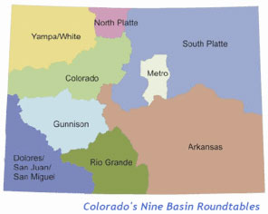
Basin roundtable boundaries

On the supply side, Eklund said representatives from each of the state’s river basins have delineated their own plans for storage projects. If 80 percent of those are approved and built, the state’s across-the-board ability to store water would be boosted by about 400,00 acre feet per year.

As for cost, Eklund said “back of the napkin” estimates indicate there’s about $20 billion worth of investment needed in Colorado’s water infrastructure.

However, he said, about $17 billion of that is already accounted for in existing budgets for operations, maintenance and capital expenditure developed by the local and regional water utilities — leaving a gap of $3 billion that has to be met by other avenues such a state funding.

Watchers, including the Denver Metro Chamber of Commerce, say they want the plan to contain specific, actionable, measurable steps needed to reach the goals.

“Gone are the days that we can look to someone else to solve this, and this is one of those issues that we don’t want someone to step in and tell Colorado, ‘this is how it will be solved,’” said Kelly Brough, president and CEO of the Denver Metro Chamber of Commerce, during a water-focused forum in October sponsored by the chamber…

“It brought everyone together to talk about water and how we’ll collectively move forward on this slow-moving train of water supply and demand and population growth that’s coming,” said Abby Burk, the western rivers outreach specialist for the Rocky Mountain chapter of the National Audubon Society.

But after all the talk, across so much of the state, the key measure of the water plan’s success will be what happens next, say many who’ve been involved in the process.

“The key will be in the implementation — the state as well as water users, including Denver Water, need to step up and develop real proposals,” said Jim Lochhead, CEO of Denver Water, the state’s biggest water provider that has more than 1 million customers in Denver and surrounding suburbs.

“There are things that can be done immediately through the state government or in the legislature — but the key will be to begin to start doing things: pilots, experiments, initiatives. We’ve had a significant time to talk, now is the time for action,” Lochhead told the Business Journal.

Bart Miller, the director of the environmental advocacy groups’ Healthy Rivers Program, called the plan “a step in the right direction because it has statewide goals, has funding, but also the question will be in the implementation and funding areas.”

Eklund said the plan will call for several things, in addition to the water conservation and storage goals:

  • Streamlining the permitting process, so that problems and concerns are addressed early in the process, and hopefully preventing projects from being left in limbo for years.
  • Expanding the use of comprehensive land use plans that talk about water supplies.
  • Currently, 12 percent of Coloradans live in an area that’s covered by such a plan. The state’s water plan sets a goal of having 75 percent of the state’s population covered by a comprehensive land use plan that includes water.
  • Creating alternatives to “buy and dry,” a historical trend in which Colorado’s towns and cities buy water used for farming and ranching and transferring it to urban uses on lawns and in homes. The state currently has about 3,000 acre feet of water in an alternative program, the goal is to have 50,000 acre feet of agriculture water in such a program.

“We need alternatives that are market competitive, so that municipalities are willing to do them because they are faster, cheaper, and easier to do than the traditional way,” he said.

MtSoprisSinjin Eberle

Protecting the health of the state’s environment, including its rivers, streams and the watershed — the forests above the streams.

Currently, Colorado has management plans that cover 1.5 percent of the state’s streams and rivers; the plan calls to boost that to 80 percent. Of the state’s 87 watersheds, 42 have master plans in place. The new water plan calls for raising that to 80 percent of the water sheds.

As for diverting more water from the Western Slope to the more populous Front Range, a contentious idea that’s caused decades of battles over the state’s water, the plan includes a seven-point list of principals to guide future discussions about diversions, Eklund said.

“Instead of duking it out in water court, let the seven principals guide the discussion,” Eklund said.

“If two parties are going to get into a negotiation about moving water, then they need to tick through the seven points. And if you do that, and address the Western Slope concerns and give the Front Range the certainty that they won’t be stonewalled to death — then the project has a chance of being considered,” he said.

San Luis People's Ditch via The Pueblo Chieftain
San Luis People’s Ditch via The Pueblo Chieftain

EPA and Partners Launch Challenge to Recycle Nutrients from Livestock Waste

Here’s the release from the Environmental Protection Agency:

The U.S. Environmental Protection Agency is partnering with the U.S. Department of Agriculture, pork and dairy producers, and environmental and scientific experts to launch the Nutrient Recycling Challenge, a competition to develop affordable technologies that recycle nutrients from livestock waste.

Every year, livestock producers manage more than one billion tons of manure, which contains valuable nutrients – nitrogen and phosphorus – that plants need to grow. Challenge participants will develop technologies that extract nutrients from livestock manure to generate products with environmental and economic benefits that farmers can use or sell.

“Scientists and engineers are already building technologies that can recover nutrients, but further development is needed to make them more effective and affordable,” said EPA Administrator Gina McCarthy. “The Nutrient Recycling Challenge will harness the power of competition to find solutions that are a win-win for farmers, the environment, and the economy.”

During the four-phase competition, innovators will turn their concepts into designs and eventually into working technologies that livestock farms will use in pilot projects.

Phase I, which begins Nov. 16 and ends Jan. 15, calls for papers outlining ideas for these technologies. Phase I prizes will be announced in March and include up to $20,000 cash to be split between up to four semi-finalists; invitation to a two-day partnering and investor summit in Washington, DC; and entry into subsequent phases of the challenge with larger awards. Final awards will be announced January 2017, with farm demonstration pilots to follow.

Partners in the Nutrient Recycling Challenge are:

• American Biogas Council
• American Society of Agricultural and Biological Engineers
• Ben & Jerry’s
• Cabot Creamery Cooperative
• Cooper Farms
• CowPots
• Dairy Farmers of America
• Innovation Center for U.S. Dairy
• Iowa State University
• Marquette University
• National Milk Producers Federation
• National Pork Producers Council
• Newtrient LLC
• Smithfield Foods
• Strategic Conservation Solutions
• Tyson Foods
• U.S. Department of Agriculture
• Washington State University
• Water Environment Research Federation
• World Wildlife Fund

For more information: http://www.nutrientrecyclingchallenge.org

#AnimasRiver: Colorado disputes key part of EPA’s account of toxic waste spill from old mine — USNews.com

A “get well soon” balloon floats in the contaminated waters of the Animas River flowing through Durango on Monday afternoon August 10, 2015 -- photo The Durango Herald, Shane Benjamin
A “get well soon” balloon floats in the contaminated waters of the Animas River flowing through Durango on Monday afternoon August 10, 2015 — photo The Durango Herald, Shane Benjamin

From USNews.com (Dan Elliott):

Colorado officials say they didn’t endorse an Environmental Protection Agency cleanup operation that caused a massive spill of toxic wastewater from an inactive mine, disputing a key claim by federal agencies that state experts signed off on the plan.

State officials neither approved nor disapproved of the operation, according to a Sept. 2 letter to the EPA from Mike King, executive director of the Colorado Department of Natural Resources. The Associated Press obtained the letter through an open records request.

King’s letter is a blow to the EPA’s contention that outside technical experts supported its plan to push a drainage pipe through debris covering the entrance to the Gold King Mine in southwestern Colorado on Aug. 5. The debris gave way, unleashing a torrent of 3 million gallons of wastewater laden with heavy metals from inside the mine.

The letter also raises questions about an investigation of the spill by the federal Bureau of Reclamation, which claimed two mining experts from the state approved of the project. Some members of Congress have questioned whether the bureau’s investigation was sufficiently independent. The bureau is part of the Interior Department and is separate from the EPA.

The Bureau of Reclamation had no immediate comment on King’s letter. Spokesman Peter Soeth said Thursday the employee who wrote the report was out of the office and could not be reached.

The EPA said it was reviewing King’s letter. In a written statement, the agency said only its inspector general received the letter, and other officials didn’t see it until Tuesday…

An EPA internal review made public Aug. 26 said the two mining experts from the state Department of Natural Resources and EPA officials believed the water inside the mine was under little or no pressure. The EPA said the state experts were at the Gold King Mine on the day of the spill in a supporting role for the cleanup operation.

But King’s letter said the state experts didn’t make any determination of how high the water pressure was inside the mine. He said they were not involved in the Gold King operation and had gone to the mine only because an EPA official at the scene wanted to talk to them about future work there, not the work going on that day.

The Bureau of Reclamation report, released seven weeks after King’s letter, described the two state experts as being even more deeply involved than the EPA report did.

The state experts discussed the EPA plan for the Gold King Mine with the chief EPA official on scene “and were in agreement to proceed,” the Bureau of Reclamation report said.

In an email to the AP, Department of Natural Resources spokesman Todd Hartman said that was incorrect. He did not elaborate.

Hartman said a Bureau of Reclamation official spoke with both the state mining experts before the report was issued.

He said the department would not make the two experts available for an interview. They were identified as Bruce Stover, director of the Inactive Mine Reclamation Program, and Allen Sorenson, project manager and geological engineer for the same program.

“We appreciate what EPA was attempting to do at the Gold King mine,” King said later Thursday in a statement. “We share EPA’s desire to see those historic mine sites cleaned up. The investigation’s conclusions into the events surrounding the discharge were not consistent with our staff’s involvement and we felt it important to make sure the investigators were aware of our perspective. The letter speaks for itself.”

Providers utilizing the Denver Basin Aquifer are moving towards supply security

Denver Basin aquifer map

From the Centennial Citizen (Paul Donahue and Eric Hecox):

Is our water future secure?

It’s a question on the minds of many in Castle Rock and the entire south metro Denver region — and for good reason. After all, water is what makes our outstanding quality of life possible. If we want future generations to enjoy our communities as we do, we must ensure they have access to a secure and sustainable water supply that meets their future needs.

From conversations throughout the region, we know Castle Rock residents and those in the entire south metro area understand the critical role water plays in delivering the quality of life we desire for our children, in addition to supporting property values, job creation and economic growth.

We know residents are aware the region historically has relied too heavily on declining groundwater supplies and must diversify its supply for long-term sustainability. We know they view water as a top priority for the region and support an all-of-the-above approach that includes conservation and reuse, storage and new renewable supplies.

We also know Castle Rock residents as well as residents across the south metro area value partnership among leaders throughout the region to get the job done in the most economically responsible manner. Working together to secure water rights, build infrastructure and efficiently use storage space helps spread the costs and the benefits to customers throughout the region.

The answer to the question on people’s minds is not clear-cut. While our region is on the path to delivering a secure water future for generations to come, this effort is ongoing and will require continued support from our communities to see it through to the end.

The good news is that we have a plan, and we are executing that plan.

Thanks to innovative conservation approaches, the region has seen a 30 percent decrease in per capita water use since 2000. That means the typical south metro household or business, including those in Castle Rock, is using 30 percent less water than just 15 years ago. Declines in the region’s underground aquifers — historically the main water source for the region — have slowed considerably in that same time period, a testament to efforts across the region to diversify water supplies and maximize efficiency through reuse.

At the same time, major new water infrastructure projects are coming online throughout the region that bring new renewable supplies, storage capacity and reuse capabilities. These include the WISE (Water Infrastructure and Supply Efficiency) Partnership with Denver Water, Aurora and several other regional organizations including Castle Rock Water, the Chatfield Reallocation Project, Rueter-Hess Reservoir, the Northern Project and Castle Rock’s Plum Creek Purification Facility, to name a few.

The 13 members that make up the South Metro Water Supply Authority provide water to 80 percent of Douglas County and 10 percent of Arapahoe County. Together, they are partnering among each other as well as with local government leadership and water entities across the region and state to execute their plan to secure a sustainable water future for the region.

Since becoming a member of the South Metro Water Supply Authority, Castle Rock Water has helped lead implementation of the WISE project, new water storage reservoir projects and other regional renewable water supply efforts. WISE water will be available to Castle Rock residents by 2017 and even earlier for some of the other South Metro residents. A project like WISE represents as much as 10 percent of the renewable water needed for both current and future residents in Castle Rock.

The members of the South Metro Water Supply Authority, including Castle Rock, each have long-term water plans. Through partnerships, these projects are made possible by sharing in the needed investments and other resources when completing the time-consuming task of acquiring additional renewable water and building the required infrastructure.

This collaboration is supported by the state and is in line with the Colorado Water Plan. This regional support has been critical in providing feasible strategies to ensure water for future generations.

Is our water future secure? No, not yet. But we’re well on our way to getting there.

Paul Donahue is the mayor of Castle Rock and has served on the town council for eight years. Eric Hecox is the director of the South Metro Water Supply Authority, a regional water authority made up of 13 water provider members that collectively serve more than 300,000 residents as well as businesses in the south metro Denver area. South Metro Water’s membership spans much of Douglas County and parts of Arapahoe County, including Castle Rock, Highlands Ranch, Parker and Castle Pines.

Trustees approve contract for hydroplant, hatchery flood work — Estes Park Trail-Gazette

Estes Park
Estes Park

From the Estes Park Trail Gazette (David Persons):

The Estes Park Town Board approved on Tuesday night a professional services contract and a design-build contract to the FlyWater/Otak team for the Fall River hydroplant and upper Fish Hatchery reaches stabilization project.

The Fall River channel and stream banks between the Rocky Mountain National Park boundary and downstream of the western-most Fish Hatchery Bridge (Project Reach) experienced significant damage as a result of the 2013 flood and now pose a public safety hazard.

This damage included the loss of fish habitat, damage to the channel, significant bank erosion, and areas of considerable deposition. Approximately 100 feet of the historic 30-inch iron penstock connecting the Cascade Dam and the Hydroplant was exposed due to stream bank erosion.

The proposed project work consists of approximately 3,250 linear feet of stream bank stabilization and channel restoration along a reach of Fall River. The project reach is defined by 2,700 feet from the Hydroplant Museum going west to the border of Rocky Mountain National Park and 550 feet going east of the Hydroplant Museum defined as the Upper Fish Hatchery reach. These contract agreements include finalizing the remaining portion of the design and completing all construction work.

Estes Park Environmental Planner Tina Kurtz explained to the board that the $300,000 two-phase project will be funded in two ways.

Kurtz said a CDBG-DR grant for $150,000 is pending the Environmental Assessment which should be completed later this month. The funding request is expected to be granted in December. An additional grant for $150,000 from Colorado Senate Bill 14-179 requires a 1-to-1 match. The CDBG-DR grant would be considered that match…

Later on Tuesday night, the town board voted to reallocate $780,000 in the CDBG-DR grant from the Scott Ponds and put it toward the Fall River hydroplant and upper Fish Hatchery reaches stabilization project.

Mining industry backs ‘Good Samaritan’ fix for Gold King — The Colorado Statesman

Summitville Mine superfund site

From The Colorado Statesman (David O. Williams):

Mention the practice of re-mining to anyone familiar with Colorado mining history, and the specter of the 1990’s Summitville disaster — dwarfing last summer’s Gold King Mine spill into the Animas River — is likely to loom large.

Taxpayers have doled out more than $150 million to try to clean up the mess left by a Canadian company that declared bankruptcy in 1992 after it dug up old mine works in the San Juan Mountains near Del Norte and piled them into a cyanide heap leach to extract gold, silver and copper.

But once the company pulled the plug, acid mine drainage made its way downstream, where it killed off a 17-mile stretch of the Alamosa River. Colorado and federal regulators had to scramble to keep the situation from becoming even worse.

Re-mining, or going back in to recover minerals from old, abandoned mines, is now being mentioned as a possible means of getting modern mining companies to help clean up the toxic drainage from thousands of old, abandoned hardrock mines contaminating streams across the West – like the Gold King Mine near Silverton.

“Yes, I support [re-mining] as long as it’s done in a safe and responsible manner,” U.S. Rep. Doug Lamborn, a Colorado Springs Republican, recently told The Colorado Statesman. Lamborn last month introduced the Locatable Minerals Claim Location and Maintenance Fees Act to “incentivize private sector actors to remediate abandoned mine lands.”

Under Lamborn’s bill, so-called “Good Samaritan” permits would provide limited liability protections for non-profit groups, local governments and the mining industry to clean up abandoned mines. Under current law, Lamborn says the most qualified parties for cleanup efforts are “scared away” by the possibility of assuming 100-percent liability for old mine sites.

Re-mining is floated as a way to incentivize and help pay for cleaning up old mines, but some environmental groups balk at the idea of letting modern mining companies take on old mine messes because of the possibility of making things worse.

“That’s why we wrote the bill so that if you act in a grossly negligent or even willfully negligent way, you still have huge liability, so only people who are using good-faith efforts are able to be exempt from liability,” Lamborn said. “Anyone else who’s a bad actor is not let off the hook.”

Lauren Pagel, policy director of the nonprofit environmental group Earthworks, testified last month before the U.S. House Subcommittee on Water Resources and Environment that the mining industry cannot be allowed to call the shots with Good Samaritan cleanup legislation.

“If a ‘Good Sam’ version passes that the mining industry favors, it would allow a private entity to create an Animas [River]-type spill, and exempt the polluting party from responsibility for their mistake or from compensating damaged communities downstream,” Pagel said.

But Stuart Sanderson, president of the Colorado Mining Association, said Good Samaritan legislation will remove the disincentives to private-sector cleanups of abandoned mines, which include perpetual liability under the Clean Water Act and operator status under the Comprehensive Environmental Response, Compensation, and Liability Act, or CERCLA — the law overarching EPA Superfund.

“Public sector and EPA cleanups will continue, but to the extent that private-sector mining companies are allowed to participate, there is no harm in allowing those companies to help defray costs through the removal of any minerals they may be able to extract,” Sanderson said.

Doug Young, senior policy director of the Keystone Policy Center, a nonprofit conflict-resolution organization based in Keystone, is working is help draft Good Samaritan legislation that works for everyone. He told the House Subcommittee on Water Resources and Environment he’s been working on the issue for 20 years and hopes to avoid the usual pitfalls.

“There are folks who are nervous about the idea of re-mining, because it could be a loophole that could be abused, meaning people go in and the cleanup is secondary to recovering minerals,” Young told The Statesman, adding that cleanup has to come first. “We don’t want more Summitvilles or more Gold King Mines. There’s a way you can craft it to be careful about that.”

Good Sam sans mining reform

Pagel argues the EPA already has a process called an Administrative Order of Consent that removes liability for groups truly interested in cleaning up old mines. What’s really needed, in her opinion, is reform of the antiquated 1872 Mining Law, which does not require royalties for mining hardrock minerals on public lands. Such a pool of money could be used for cleanup of the thousands of abandoned mines leaching into streams around the West.

“The only way to begin to address the pollution associated with old mine sites is to create a robust Hardrock Mine Reclamation Fund — similar to the fund that was created in the 1970s for the coal mining industry,” Pagel testified.

Lamborn, however, says mining reform is a non-starter in a Congress controlled by his party, primarily because it will kill mining projects and jobs.

“[Earthworks’] approach to reforming the mining act is never going to happen, so they’re chasing a pipe dream — plus it’s a totally different subject anyway,” Lamborm said. “To obtain a global solution is simply beyond what can be accomplished right now, so some people are letting the perfect be the enemy of the good.”

Colorado Sen. Michael Bennet last week joined New Mexico Sens. Tom Udall and Martin Heinrich, all Democrats, introducing the Hardrock Mining and Reclamation Act of 2015, which would reform the mining act to charge royalties and create a cleanup fund.

But Young, who worked on Good Samaritan legislation for years for Tom Udall’s cousin, former Colorado Sen. Mark Udall, says mining reform is too tough a fight in the current congressional gridlock.

“If you create a program of Good Samaritan and deal with the liability, the funding will come without having to do a frontal, uphill political battle of either amending the 1872 Mining Law or proposing other fees and royalty funding provisions,” Young said, adding there are 30 watershed groups in Colorado focused primarily on abandoned mine drainage.

Superfund tour through Colorado paints positive picture — The Durango Herald

From The Durango Herald (Jonathan Romeo):

It was a long, difficult road as the community of Leadville went through a more-than-20-year process through the Environmental Protection Agency’s hazardous cleanup Superfund program. But local government officials here on Thursday told a large constituency of Southwest Coloradoans that, ultimately, it was worth it.

Various agencies from the Animas River watershed are on a three-day tour of several Superfund sites in Colorado, hoping to gain knowledge on the process as stakeholders look to make a decision about long-term water treatment in the Animas basin.

The situation in Leadville, in many ways, has a striking similarity with the leaking mine network north of Silverton – with its long mining history, relative isolation and fragile economy…

But after more than a century of unregulated mining in Leadville, a two-hour drive west of Denver, an adit suffered a blowout, causing a die-off along the Arkansas River down to Pueblo. In 1983, Leadville was placed on the EPA’s Superfund list, just a few years after the program was signed into law by President Jimmy Carter.

It wasn’t until 2007 that the town was officially taken off the National Priorities List. After the many battles between local, state and federal agencies, local officials there said it left a bittersweet feeling throughout the community.

“In the beginning, it definitely had an impact on our economic development,” said Howard Tritz, an assessor at the time. “It was a real obstacle. But the stigma of being a Superfund site has pretty much blown away; people are starting to come back here. It was bittersweet.”[…]

Melissa Sheets, a reclamation project manager with the Colorado Department of Public Health and Environment, said this week’s tour, which includes a number of stakeholders, is a sign the agencies have learned from past mistakes in dealing with local communities.

“I think we’re learning as Superfund grows up,” Sheets said. “Unfortunately for this community (Leadville), they got the Superfund designation when this program was brand new, so I think they got a lot of the bumps in the road. This outreach we’re doing is absolutely unprecedented. We’re trying to make sure everyone has an opportunity for input.”

After visiting Leadville, the group went to Minturn’s Eagle Mine Superfund site, where residents said there really was no other option beside Superfund.

“There’s always some tension and disagreement as to what cleanup measures are going to be most effective,” said Bob Weaver of Leonard Rich Engineering. “But it’s really important to realize everybody wants to achieve the same goal. You’re not always going to agree, but it’s a lot better than doing nothing.

Representatives from the Animas River were sure to point out the many differences between Leadville and Minturn, ranging from potentially responsible parties to differences in geology. But San Juan County Commissioner Ernie Kuhlman said overall it’s been a productive trip.

“I’ve learned a hell of a lot,” he said. “Anything we’re going to get is from working together. That’s what we’re doing here.”

Durango Mayor Dean Brookie said seeing the actual physical implementation of Superfund helped push the decision-making process…

Leadville Mayor Jaime Stuever offered one last bit of advice for the group before a tour of the California Gulch Superfund site.

“We live in an environment in today’s world were we have problems,” he said. “If you look at how many years mining took place here, you realize it takes a long time to clean up a mess that’s been here many, many years. How could we have done it ourselves? We couldn’t have done it ourselves.”

Aspinall Unit operations update: Gunnison River through Black Canyon streamflow to increase to 1100 cfs

From email from Reclamation Erik Knight:

Releases from Crystal Dam will be increased from 600 cfs to 1100 cfs on Monday, November 16th. The purpose of this increase is to lower Blue Mesa Reservoir down towards the winter icing target. The current content of Blue Mesa Reservoir is 673,000 acre-feet which is 81% full.

Flows in the lower Gunnison River are currently above the baseflow target of 1050 cfs. River flows are expected to stay above the baseflow target for the foreseeable future.

Pursuant to the Aspinall Unit Operations Record of Decision (ROD), the baseflow target in the lower Gunnison River, as measured at the Whitewater gage, is 1050 cfs for the remainder of the year.

Currently, there are no diversions into the Gunnison Tunnel and flows in the Gunnison River through the Black Canyon are 600 cfs. After this release change Gunnison Tunnel diversions will still be at 0 cfs and flows in the Gunnison River through the Black Canyon should be around 1100 cfs. Current flow information is obtained from provisional data that may undergo revision subsequent to review.

Sunrise Black Canyon via Bob Berwyn

The latest ENSO Diagnostic Discussion is hot off the presses from the Climate Prediction Center

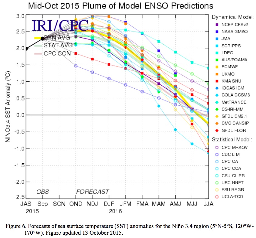
Mid-October 2015 plume of ENSO predictions via the Climate Prediction Center

Click here to read the discussion. Here’s an excerpt:

<blockquote>ENSO Alert System Status: El Niño Advisory

Synopsis: El Niño will likely peak during the Northern Hemisphere winter 2015-16, with a transition to ENSO-neutral anticipated during the late spring or early summer 2016.

A strong El Niño continued during October as indicated by well above-average sea surface temperatures (SSTs) across the central and eastern equatorial Pacific Ocean. Most Niño indices increased during the month, although the far eastern Niño-1+2 index decreased, accentuating the maximum in anomalous SST farther west. The subsurface temperature anomalies also increased in the central and eastern Pacific, in association with another downwelling equatorial oceanic Kelvin wave. Low-level westerly wind anomalies and upper-level easterly wind anomalies continued over the western to east-central tropical Pacific. Also, the traditional and equatorial Southern Oscillation Index (SOI) values remained negative. These conditions are associated with enhanced convection over the central and eastern tropical Pacific and with suppressed convection over Indonesia. Collectively, these atmospheric and oceanic anomalies reflect a strong and mature El Niño episode.

Most models indicate that a strong El Niño will continue through the Northern Hemisphere winter 2015-16, followed by weakening and a transition to ENSO-neutral during the late spring or early summer. The forecaster consensus remains nearly unchanged, with the expectation that this El Niño could rank among the top three strongest episodes as measured by the 3-month SST departures in the Niño 3.4 region going back to 1950. El Niño will likely peak during the Northern Hemisphere winter 2015-16, with a transition to ENSO-neutral anticipated during the late spring or early summer 2016.

El Niño has already produced significant global impacts. El Niño is expected to affect temperature and precipitation patterns across the United States during the upcoming months (the 3-month seasonal outlook will be updated on Thursday November 19th). Seasonal outlooks generally favor below-average temperatures and above-median precipitation across the southern tier of the United States, and above-average temperatures and below-median precipitation over the northern tier of the United States.

Snowpack news: Average to above average except Rio Grande, storm due in mountains Monday

Click a thumbnail graphic below to view a gallery of snowpack data for Colorado.

#Drought news: Abnormal dryness (D0) reduced in NW #Colorado

Click here to go to the US Drought Monitor website. Here’s an excerpt:

The Central Great Plains, Middle Mississippi Valley, and Lower Ohio Valley

Looking at the area from Indiana westward through Nebraska and Kansas, beneficial light to moderate precipitation in the western half of Nebraska and adjacent Colorado, some of which fell as snow. This brought an end to the abnormal dryness in the southern Nebraska Panhandle and adjacent Colorado. Farther south and east, only light precipitation at best fell from central parts of Indiana, Illinois and Missouri westward through Kansas, primarily in eastern sections of the region. As a result, limited D0 and D1 expansion occurred in parts of Kansas, where very little precipitation fell. No changes seemed warranted farther east. Most of eastern Kansas and the southwestern quarter of Missouri received less than half of normal precipitation during the last 30 days, as did portions of central Indiana and Illinois. Precipitation deficits of at least 4 inches have accumulated in most of the same region since early August, with totals in much of central Missouri 6 to 8 inches below normal during this period…

The Rockies, Intermountain West, and Far West

Moderate to heavy precipitation fell on the Sierra Nevada, northwestern California, western sections of Washington and Oregon, northern sections of the Rockies and Intermountain West, scattered areas from western Colorado to central Arizona, and a few other isolated spots. Other locations received little, if any. The wet/snowy season is off to a rapid start in the Intermountain West and West Coast States. Snowpack is well above normal for this time of year in the Sierra Nevada and parts of Nevada where drought has seemed intractable, Reno Tahoe Airport recorded 4.2” of snow November 9-10 (including a daily record 2.4” on the 9th), and over a foot blanketed some areas northeast of the city. But given the long-term nature of the drought in much of the Far West, only scattered areas of improvement were noted. D1 in south-central Idaho improved to D0, areas of D3 shrank a little in western Idaho and west-central Montana, severe drought eased to moderate levels in central Washington, abnormal dryness was eliminated in northwestern Colorado, coverage of D1 and D2 declined in southeastern Arizona, and a few other isolated areas saw improvement. Areas where drought was more entrenched will need abundant precipitation to continue much farther into the wet season before any notable improvement could evolve…

The Southeastern Great Plains, Lower Mississippi Valley, and Adjacent Southeast

Moderate to heavy precipitation fell on most of this region. Most areas from the Mississippi/Ohio Confluence southward through the Lower Mississippi Valley, southeastern Oklahoma, and eastern Texas reported at least an inch of precipitation, with 2 to locally over 5 inches measured in a swath from southern Missouri into northwestern Arkansas, plus an area farther south extending from southeast Oklahoma and northeastern Texas eastward through southern Arkansas, much of Louisiana, and some parts of Mississippi outside the areas of abnormal dryness and moderate drought. Large areas of improvement were introduced in the wetter areas, and most other areas were unchanged; however, D0 was expanded into parts of eastern Arkansas, southwestern Tennessee, and northwestern Mississippi that missed most of the precipitation. The eastern half of this area received only 50% to 75% of normal rainfall in the last 30 days, and deficits of 4 to locally 6 inches have accumulated since early September…

Looking Ahead

During November 12-16, the heaviest precipitation should fall on windward slopes in western Washington and northern Idaho. Peak values of 12 to nearly 18 inches are anticipated in the northwesternmost reaches of Washington while totals may top 6 inches in northernmost Idaho. Substantial totals are also expected in western Oregon and far northwestern California, with amounts topping out in the 2 to 4 inch range along the Oregon Coast. Relatively heavy precipitation is also anticipated across the northern half of the Great Lakes, with 2 to 3 inches forecast in northwestern Wisconsin and adjacent areas. Meanwhile, moderate precipitation (with amounts above 2 inches only in a few isolated locations) is expected across the northern half of New England and New York, far southern Florida, the southeastern Great Plains and western Lower Mississippi Valley, and parts of the northern Sierra Nevada and southern Cascades. Temperatures should average well above normal (5 to 10 degrees) in the northern half of the Plains and much of the Great Lakes Region. In contrast, temperatures should average around 3 degrees below normal in the Great Basin and central Intermountain West.

For the ensuing 5 days (November 17-21), the odds at least slightly favor wetter than normal conditions nationwide, except in a small part of the northern Plains and in a swath across the Big Bend of Texas, southern sections of Arizona and New Mexico, and central and southern California. All of Alaska has enhanced chances for above normal precipitation as well. The best chances for wetness are in the southern half of the Mississippi Valley. We should see warmer than normal temperatures on average in the central and eastern parts of the country and cooler than typical conditions from the Rockies westward.

Arkansas Basin roundtable meeting recap #COWaterPlan

From The Pueblo Chieftain (Chris Woodka):

Now that a plan for Colorado’s water future is nearly finished, there are some concerns it might not have much of a future itself.

“What’s going to happen to the Colorado Water Plan?” asked Jim Broderick, executive director of the Southeastern Colorado Water Conservancy District, at Wednesday’s Arkansas Basin Roundtable meeting. “Is it going to sit on a shelf?”

Alan Hamel, who represents the basin on the Colorado Water Conservation Board, was quick to reply that the final plan has more moving parts than its encyclopedic draft.

“There are dates so we have guidance and ways we can measure progress,” Hamel said. “If it sits on the shelf, we’ve wasted a lot of people’s time.”

The water plan will be finalized by the CWCB and presented to Gov. John Hickenlooper next week in Denver. The governor ordered the plan in 2013, and it has consumed the state’s roundtables for the past two years.

The primary purpose of the water plan, initially was to fill the supply gap for the state’s growing population, but it evolved to include conservation, land use and storage goals as well. It also includes agriculture, watershed health and funding goals.

In the process, the roundtables also developed basin implementation plans of their own.

It was clear at Wednesday’s meeting that the roundtable is not content to sit on its plan. Gary Barber, a former chairman of the roundtable, was hired to implement the plan.

State grant funding for the position is for just one year, and Barber’s job will be to keep projects moving ahead, said Sandy White, chairman.

Meanwhile, the roundtable has hired Deb Phenicie to coordinate its watershed health initiative and is in the process of selecting a coordinator for outreach and water education, also funded through the roundtable process.

Hamel tied the roundtable’s actions to the course the CWCB will take in implementing the water plan.

“It’s imperative for the CWCB to have regular reviews,” Hamel said, noting there was some disagreement about how often the state water plan would be reviewed. “Our goal in the Arkansas basin is to keep the project list current. The CWCB has to take a leadership role as we go from governor to governor.”

Colorado Water Plan website screen shot November 1, 2013

N.D. judge takes lead role in fight over #CleanWaterRules

From EENews.net (Jeremy P. Jacobs and Annie Snider):

With the stroke of his pen, Ralph Erickson catapulted himself to the center of a decades-long politically charged battle over the country’s foremost water law.

The little-known North Dakota federal district judge blocked the Obama administration’s contentious Waters of the U.S. rule on Aug. 28, hours before it was scheduled to go into effect.

A George W. Bush appointee, Erickson sided with the challengers’ arguments, ruling U.S. EPA and the Army Corps of Engineers overstepped their authority under the Clean Water Act.

Declaring the agencies had developed the rule through a process that was “inexplicable, arbitrary and devoid of a reasoned process,” he granted the request of 13 states for a preliminary injunction, halting the rule while the lawsuit plays out.

The rule’s foes sought injunctions in lawsuits filed across the country, but Erickson was the only federal district judge to grant one — though he later limited it to the 13 states in the case before him.

In the months since, Erickson’s decision has become ammunition for opponents of the water rule, one of the Obama administration’s most significant environmental regulations.

They have wielded it in the legal arena, where challengers used it to persuade a federal appeals court to extend the stay nationwide. On the political front, Erickson’s words have been quoted in lobbying letters, in tweets and on the floor of the Senate…

A federal judicial panel last month declined to consolidate more than a dozen district court challenges to the rule, allowing them to move forward on parallel tracks.

The decision could give Erickson — who has already said that challengers’ arguments have “a substantial likelihood of success” — the first crack at ruling on whether the regulation is legal.

The Department of Justice has been trying to wrest the case from Erickson’s courtroom. DOJ contends that all the litigation belongs in a federal appeals court, not district court — a question that is pending before an appellate court in Cincinnati.

But the challengers are already pressing Erickson to move ahead with his case now, contending that he has already decided that authority rests with him. And yesterday, Erickson’s court agreed to move forward with the case quickly.

While any opinion is likely to be appealed, Erickson’s moves could set the stage for what is likely to be years of legal battles.

It’s a high-stakes role for a North Dakota judge who is well-respected locally as a no-nonsense, hardworking and at times talkative judge with limited experience on environmental and administrative law cases.

rifflesaspenjournalismbrentgardnersmith

Lamar councillors authorize drinking water infrastructure loan

Water infrastructure as sidewalk art

From The Lamar Ledger (Chris Frost):

The Lamar City Council authorized Mayor Roger Stagner to sign the Lamar Main Street Water Distribution Water Replacement Loan Application from the Colorado Drinking Water Revolving Fund during the Monday, Nov. 9, City Council meeting.

As part of the Colorado Department of Transportation (CDOT) Main Street Resurfacing project, the city plans on replacing 21,000 linear feet of water main.

The city has made application for the planning stage of the project, Public Works Director Pat Mason said, which is a $112,00 Department of Local Affairs (DOLA) loan.

The total cost of the project is $3,246,800. The loan for the revolving fund is for $1,612,800 as matching funds. The loan will span 30 years and have a zero percent interest rate.

“There’s a chance we may be able to get some grant funding that we can use as part of this match,” Treasurer Kristin McCrea said. “In the application process we did the maximum for now because that was our guarantee. There still is a lot of discussion going on, so we went ahead and applied for what we would need to match.”

6 Places Where Melting Snow Means Less Drinking Water — National Geographic

Here’s a report from Brian Clark Howard writing for National Geographic. Here’s an excerpt:

Climate scientists have a pretty good idea what is going to happen to much of the Earth’s snow as the planet warms over the next century: It’s going to melt. But the melting will occur at different rates in different places, which has major implications for the 2 billion people who rely on snowmelt for water.

What’s more, over the next few decades, some areas are likely to see increased snow and rainfall as climate changes in complicated ways.

“Such confounding factors complicate how water managers will be able to respond to climate change,” says Justin Mankin, a climate scientist at Columbia University’s Earth Institute.

In order to help water providers better forecast their supply, Mankin led a team of scientists in a new study published Thursday in the journal Environmental Research Letters. Climate models were used to predict changes in rainfall and snowpack across basins in the northern hemisphere that supply water to large numbers of people. These areas include much of the American West, the Middle East, Central Asia, and southern Europe.

The scientists concluded that overall there is a 67 percent risk of less water available from snowpack by 2060. But over the next few decades, some regions face more risk than others.

In some areas precipitation could actually increase. That’s because a warmer atmosphere can hold more moisture. Yet “the extent that people have the capacity to capture and use that water is a different matter,” says Mankin.

Snow’s Holding Power

Traditionally, when precipitation falls as rain only some of it can be captured in aquifers, lakes, and manmade reservoirs. When the moisture falls as snow, it often sticks to mountains for long periods of time, where it melts slowly, trickling down as a nearly steady water supply. (Read more about this process.)

“In the future, water managers are going to have to adjust to a decrease in the amount of water available from snowpack,” says Mankin. Strategies could include building more reservoirs, either above or below ground, tougher water conservation measures, desalination, deeper wells, or other plans…

The Colorado River Basin

Home to 11 million people, the Colorado River system fared only somewhat better in the analysis, with a decline in snowpack in 74 percent of the tests.

“Our water supply is not going to look the same in the future,” says Mankin. “We’re going to have to get innovative about what management practices really make sense.” (Read more about the embattled Colorado River.)

Rio Grande Basin

The Rio Grande Basin that straddles Mexico and the U.S. is home to 16 million people. Like the Central Valley, in 95 percent of the trials run through the climate models, the snowmelt runoff fell short of demand by mid-century.

Local health officials voice their support for fluoride in water — Aspen Daily News

Calcium fluoride
Calcium fluoride

From The Aspen Daily News (Collin Szewczyk):

On Tuesday, Liz Stark, Pitkin County public health director, told the county’s board of health, which consists of the Pitkin County commissioners, Aspen city council member Ann Mullins, and Snowmass Village Mayor Markey Butler, that tooth decay is 100 percent preventible. She added that fluoridation is the most effective and affordable way to eradicate cavities and “reaches all sectors of the population regardless of their oral health habits or their ability to seek dental care.”

“No one is immune from getting this illness,” she said. “Preventing it can be challenging even in the most affluent communities.”

Stark noted that dental insurance is very expensive, and just because a person has it doesn’t mean they have access to good care. She added that many people don’t connect oral heath with overall physical well-being.

“We do know there’s a disconnect with how people value their oral health and how it relates to their overall health,” she said. “People are just getting it now that, what happens in your mouth does affect what happens to the rest of your body.”[…]

Stark said a community survey conducted in Snowmass Village earlier this year showed that 64 percent of respondents were in support of fluoridation.

A focus for care was on the lower-income residents of the valley, 25 percent of whom live at or below 200 percent of the federal poverty level.

In Colorado, 72.4 percent of the communities have access to fluoridated water, according to a 2012 study by the Centers for Disease Control and Prevention.

Stark said that children living in areas with fluoridation have a reduced number of cavities.

“For example, in Silt and Rifle where there is no fluoridation in their water, approximately 30 percent of those children have dental cavities,” she said. “Whereas the children who live in Glenwood Springs or Aspen, that do have fluoridated water, the rate is about 10 to 17 percent. So that is a significant difference.”

Dr. Kim Levin, Pitkin County medical officer, said the anti-fluoridation groups have created fear about the practice and its link to osteosarcoma (bone cancer), lower IQ, and Down syndrome, and cardiovascular disease. But she added that people need to look at the variables in each of the studies.

“For instance, the IQ study was at the Harvard School of Public Health with the China Medical University and included 8,000 school children,” she said. “Now in China, there are communities with very high levels of fluoride. … This study concluded overall that IQ was lowered by seven points in communities that had high fluoride in it. Some of these communities have more than 20 times the level of fluoride that we have in our water.”[…]

Tom Dunlop, county environmental public health advocate, said there are undocumented emotional and psychological costs associated with poor dental health that can be devastating to children.

“Loss of self-esteem by children who have such bad dental hygiene that they become reclusive, or they [feel] socially unacceptable,” he said. “They’re not going to be as active as a person that doesn’t have that kind of thing going on with them.”

Levin added that every dollar spent in fluoridation saves $38 in dental costs.

“Again, that doesn’t quantify all of these other psycho-social costs and medical issues that result from poor dental care,” she said.

Colorado Water Congress 2016 Annual Convention – January 27 to 29

From email from the Colorado Water Congress:

Join over 500 of your colleagues from across the state during the Colorado Water Congress 2016 Annual Convention, January 27 to 29, at the Hyatt Regency Denver Tech Center.

The convention format will be similar to last year’s including the all-day Wednesday workshops, the Wednesday evening POND reception, and the Thursday and Friday general sessions. Thursday, immediately following the CWC & CSU evening reception, we are happy to announce that once again CSU will host their 2016 Water Tables event dinner with keynote speaker, Anne Castle. The dinner theme is “The Historic One Hundred” and features hosted tables for an evening of conversation on specified topics…Friday, don’t miss the annual Aspinall Award Luncheon and the announcement of the 2016 Wayne N. Aspinall Award winner!

Early Registration is now open. Register before December 31, 2015 to receive $40 off the Annual Convention price (does not apply to the Wednesday workshops) register HERE

David Robbins and  J.C. Ulrich (Greg Hobbs) at the 2013 Colorado Water Congress Annual Convention
David Robbins and J.C. Ulrich (Greg Hobbs) at the 2013 Colorado Water Congress Annual Convention

Reclamation Releases the Final Environmental Assessment for Developing Hydropower at Drop 5 of the South Canal

South Canal hydroelectric site -- via The Watch
South Canal hydroelectric site — via The Watch

Here’s the release from the US Bureau of Reclamation (Justyn Liff/Jennifer Ward):

Reclamation announced today that it has released a draft environmental assessment for a hydropower project at Drop 5 of the South Canal, part of the Uncompahgre Project in Montrose, Colorado.

The project, proposed by the Uncompahgre Valley Water Users Association, will be located approximately four miles downstream from the Drop 4 hydropower project on the South Canal. A Lease of Power Privilege will authorize the use of federal facilities and Uncompahgre Project water to construct, operate and maintain a 2.4 megawatt hydropower facility and associated interconnect power lines.

The hydropower plant will operate on irrigation water conveyed in the South Canal and no new diversions will occur as a result of the hydropower project. Construction activities and operation of the hydropower plant will not affect the delivery of irrigation water.

The draft environmental assessment is available and can be received by contacting Jennifer Ward by phone at 970-248-0651 or email jward@usbr.gov.

Reclamation will consider all comments received prior to preparing a final environmental assessment. Comments can be submitted by email to lmcwhirter@usbr.gov or to: Ed Warner, Area Manager, Bureau of Reclamation, 445 West Gunnison Ave, Suite 221, Grand Junction, CO 81501. Comments are due by Monday, September 14, 2015.

Latest ‘The Fountain Creek Chronicle’ newsletter is hot off the presses

Fountain Creek
Fountain Creek

Click here to read the newsletter. Here’s an excerpt:

Second Annual Event A Huge Success

The numbers are in, and they are impressive.

1,550 citizens in 6 communities removed almost 9.5 tons of litter and debris from the Fountain Creek Watershed during Creek Week 2015 (September 26-October 4th).

This year’s event drew more than twice the participants and collected over 2 tons more than last year’s inaugural cleanup, thanks to new Steering Committee members, generous sponsors and hard working volunteers of all ages.

New this year was a fundraiser at Fieldhouse Brewing Company – they created a special “Creek Week IPA”, a promotion for volunteers at Navajo Hogan, insulated water bottles as prizes, heavy duty gloves and trash grabbers for volunteers to keep, a commercial and newspaper ads.

The goals of Creek Week are about fostering stewardship, raising awareness of our waterways, and making the area cleaner and safer for all to enjoy. Comments from participants about their experiences were very favorable – most indicated that they would like to see more cleanups throughout the year, that they were more aware of their impacts on our water, and that they would get involved again in the future.

The Steering Committee looks forward to continued growth and expansion of Creek Week in the coming years including increased participation, development of watershed education materials and resources for teachers, coupon books for volunteers, and in-water teams…

Click here for full Report.

#AnimasRiver: Navajo farmers seek new water source for irrigation — Farmington Daily Times

The Animas flows orange through Durango on Aug. 7, 2015, two days after the Gold King Mine spill. (Photo by Esmé Cadiente | www.terraprojectdiaries.com)

From the Farmington Daily Times (Steve Garrison):

The Navajo Nation Department of Agriculture on Monday released a preliminary survey of damages from the Aug. 5 Gold King Mine spill.

The department estimated farmers from the Shiprock and Tsé Daa K’aan chapters will suffer a total of $569,700 in damages over the next five years as a result of the spill, which released millions of gallons of toxic wastewater into the Animas and San Juan rivers. Shiprock and Tsé Daa K’aan ranchers are expected to lose $103,200 during that same period, according to data released by the department.

Charmaine Hosteen, an extension agent with the agriculture department, said the estimates are based on visits by department staff to farms in the two chapters. She said, however, the data is incomplete and has not yet been finalized.

Only 48 of 132 farms from the Tsé Daa K’aan Chapter were surveyed by employees, according to the data. In the Shiprock Chapter, 91 of 426 farms were surveyed for damages.

Hosteen said damages have not yet been assessed for the Upper Fruitland, Nenahnezad and San Juan chapters. She said a new survey will be conducted, but a date has not yet been set.

The data was presented Monday in a public meeting hosted at the Shiprock Chapter House by tribal officials from the Navajo Nation Department of Justice, Environmental Protection Agency and Department of Agriculture…

Shiprock Chapter House Farm Board representative Joe Ben Jr. said tribal officials should cede control of the irrigation head gate near the Tsé Daa K’aan Chapter House to local farmers. The head gate controls San Juan River waterflow into an irrigation canal that services farmers and ranchers throughout the region.

Ben said local farmers could act quicker than Navajo Nation officials to close the head gate in case of an emergency.

San Juan River Farm Board President Gilbert Harrison Sr. said tribal officials should consider diverting water from Navajo Dam that is intended for Navajo Agricultural Products Industry into the irrigation canal near Tsé Daa K’aan Chapter House.

Harrison said a pipeline from Navajo Dam supplies NAPI with water to irrigate 100,000 acres of land, but the tribal enterprise currently only irrigates approximately 70,000 acres of land.

Harrison said the Navajo Nation should conduct a feasibility study to determine whether that unused water could be diverted into the irrigation canal, reducing local farmers’ reliance on the San Juan River…

Donald Benn, acting executive director of the tribal EPA, said the agency was already performing water and soil testing before the Aug. 5 spill and plans to continue monitoring conditions for at least a year.

But he said his agency was not responsible for releasing the results.

“Our job as the water quality program for the Navajo Nation is to provide recommendations for the Navajo Nation president,” he said. “That is our job. What they do with the data is a different level of decision-making.”

Larimer Co. struggles with one-size-fits-all floodway rules — Fort Collins Coloradan

Cache la Poudre River

From the Fort Collins Coloradoan (Nick Coltrain):

The Larimer County Commission on Monday put the brakes on floodway regulations that focused on a Laporte neighborhood but that would have been felt county-wide.

The Laporte neighborhood, known as Cottonwillow, led a push to reform floodway regulations after residents learned stringent re-build rules cut resale values of their home to a quarter of their value, if they were able to secure an offer at all. Several of those residents lined the public seating at a non-voting work session for the county commissioners Monday.

“I want to make sure we know what we’re getting into here,” Commissioner Tom Donnelly said, regarding the regulations, which would have impacted canyon communities and county riverbank residents. “That we’re not pushing the balloon in here to see it bulge out over there.”

Donnelly was the only commissioner physically present. Commissioner Steve Johnson was attending another meeting on child welfare and Commissioner Lew Gaiter was called into the meeting.

The commission amended the county land use code earlier this year to allow property owners in floodways — areas where floods are expected to be most severe — to rebuild in cases where their buildings are substantially damaged by non-flood activities. But two of the three members balked at further action that would essentially create different tiers and regulations of floodway.

A proposal to classify floodways based on severity of anticipated flooding, one that took into account depth and flow speeds, would remove up to 93 percent of properties in a Laporte neighborhood that bumps against the Poudre River.

Colorado Water Trust eNews November 11, 2015

Alamosa River
Alamosa River

Click here to read the newsletter. Here’s an excerpt:

Absolute Alamosa

On November 5th, the Division 3 water court issued final decrees to permanently bolster streamflows in the Alamosa River. These official decisions by the water court are the final steps in a multi-year approval process spearheaded by Alamosa RIVERKEEPER®, and the Colorado Water Conservation Board (CWCB) to improve water quality and the ecological functionality of the Alamosa River. The absolute decree means that up to 2.5 cubic feet per second (cfs) of water from the Gabino Gallegos Ditch and up to 0.5 cfs in the Valdez ditch can be used to bolster streamflows in a 16-mile stretch of the Alamosa River. These instream flows are the FIRST on the Alamosa River to be enrolled in the CWCB’s Instream Flow Program and protected for this use.

The Water Trust has served the Alamosa RIVERKEEPER® project as technical consultants on water rights and instream flow information since 2008. We owe thanks for this successful water court application and complete project to a partnership between CWCB, Alamosa RIVERKEEPER®, and Terrace Irrigation Company, who owns the reservoir where the water is stored for release after the irrigation season, if needed.

How Water Is Reshaping the West — Hillary Rosner

Here’s a report from Hillary Rosner writing for Nova Next. Click through and read the whole thing. Here’s an excerpt:

“Be careful of rattlesnakes,” Brian Werner says as we walk near what will, a few years out, become the south end of Chimney Hollow Reservoir. I try to imagine what will happen to the snakes—and the bears and birds and burrowing animals—when these 1,600 acres become a lakebed. I’d been conducting an animated interview with Werner for more than an hour as we toured the region’s waterworks–reservoirs, pipelines, diversion ditches, pumps—but now, standing here, I’m speechless. Perhaps sensing my mood, Werner tries to be upbeat. He gestures to the west, where, as part of the reservoir land-acquisition deal, another 1,800 acres will be permanently protected. But it’s hard to stand beneath those ponderosas and not feel a kind of heartbreak.

Werner works for Northern Water, a public utility that delivers water to parts of eight northeastern Colorado counties and about 880,000 people. In conjunction with the U.S. Bureau of Reclamation, Northern Water administers the Colorado-Big Thompson Project, a sprawling collection of reservoirs and pipes built to send Colorado River water from the western part of the state across the Rockies (through a tunnel beneath Rocky Mountain National Park) the more populous—and growing—northeastern towns. Werner’s job title is public information officer, but after 34 years with the utility, he’s also its de facto historian, with an insider’s deep knowledge of the entire state’s water past and present, including the intricacies of water rights. (Western water law is an unfathomably complex beast predicated on a first-come-first-served system, which is why newer cities, late to the game, are struggling for rights to water that often flows right past them.)

Up and down Colorado’s Front Range—the string of cities perched along the Rocky Mountains’ eastern flanks—it’s a boom time. Fort Collins, the northernmost city, has doubled its population since the 1980s, with no sign of stopping. Farther to the east, in former rural communities like Frederick, Dacono, and Evans, pavement is spreading like weeds, subdivisions are sprouting in place of corn. The reservoir soon to drown the spectacular landscape under my feet that afternoon would deliver water to these bustling communities.

Nearby, another proposed reservoir would submerge a highway to store water from the Poudre River, which flows through downtown Fort Collins; this project will serve those same growing towns. “Some people think if we don’t build those projects, people just won’t come,” Werner says. “I wish that were the case. But it’s not gonna happen. People are going to keep moving here, because it’s a great place to live.”

Across much of the West, the story is similar. As cities and states grapple with urban growth alongside the impacts of global warming—crippling drought, a shifted timeline of snowmelt and stream flows, uncertainty about future water supplies—nothing is off the table when it comes to securing access to water. These days, the stories that make national news are more likely to be about old dams coming down than about new ones rising. That’s partly because dams coming down are still a rarity. But across the West, the local news is far more likely to be about smaller dams going up. The era of water mega-projects may be behind us, but engineers are still transforming landscapes to deliver water—an increasingly elusive and valuable commodity…

“The Reclamation era”—roughly the 1930s to the 1970s—“was big monster projects, massive dams that totally reshaped the watershed, rivers, and ecology,” says Reagan Waskom, director of the Colorado Water Institute at Colorado State University in Fort Collins. Today’s projects, Waskom says, are a series of “expansions and enlargements,” smaller-scale efforts meant to complement or shore up existing systems…

A subsidiary of Northern Water, called the Municipal Subdistrict, runs the Windy Gap project, which was built in the early 1980s to provide water for Boulder, Fort Collins, and four other Front Range cities. The system pulls water from the Colorado River and stores it in the Windy Gap reservoir on the west side of the Rockies then delivers it to Lake Granby, where it is pumped through the Big Thompson system to the eastern side. But in wet years, Lake Granby, the main reservoir for that Big Thompson system, is already full—leaving no room to store the Windy Gap water. That means in dry years, when the customers really need it, the water isn’t there.

Chimney Hollow is the solution, a way to stabilize the Windy Gap water supply. Water managers call it “firming.” Imagine that you are technically entitled to ten units of water out of a reservoir that stores 100 units. But in a dry year, the reservoir might only contain 30 units, and there are other customers besides you. In such a system, you couldn’t really depend on the reservoir for your water. That worst-case scenario is what water people call “firm yield.”

On the Windy Gap system, the firm yield is currently zero. “In the dry years, there’s no water available,” explains Werner, “and in the wet years, there’s nowhere to put it. You can’t rely on a project with zero firm yield.” Chimney Hollow, the utility contends, will give customers—the city of Erie, say— guaranteed annual delivery of their legally allotted water.

“Even with climate change, we know that there will be high flow years,” Waskom says. “When those come along, you’ve either got a place to store that water or you don’t.”[…]

There’s also the issue of whether there will continue to be enough water in the rivers to make these efforts worthwhile. “Whether you have a big reservoir or just a straw where you’re sucking water out of the river and sending it somewhere else, the question is, will the water be there?” says Jeff Lukas, a researcher with the Western Water Assessment, a think tank based at the University of Colorado. “Just because you’ve done the modeling and your scheme would’ve worked under the hydrology of last 50 years doesn’t mean it’ll work in the next 50 years.”[…]

The new world is nothing if not complex. It’s a world of tradeoffs, a world without easy answers. Still, standing on the hillside at Chimney Hollow, I’m sure of one thing: I wish there was some way to spare this spectacular place.

Thank you veterans for your service in times of war and peace

US Flag at Hoover Dam as the Olympic Torch passed over the dam in 1996

Weekly Climate, Water and Drought Assessment of the Upper #ColoradoRiver Basin

Upper Colorado River Basin month to date precipitation through November 8, 2015

Click here to read the current assessment. Click here to go to the NIDIS website hosted by the Colorado Climate Center.

Pueblo Board of Water Works 2016 budget

Pueblo photo via Sangres.com

From The Pueblo Chieftain (Chris Woodka):

Pueblo Water will hold the line on its water rate increase while stepping up big capital projects next year by transferring funds from its reserves.

“We’re in a good position,” Seth Clayton, director of administrative services, told the Pueblo Board of Water Works at its work session Tuesday. “Affordability is the most important thing.”

The water board is looking at a 3 percent rate increase when it gives final approval to the 2016 budget at its monthly meeting next week. The budget hearing will be at 2 p.m. Tuesday, 319 W. Fourth St.

The budget totals $38.7 million, and includes shifting $4.6 million from reserves. The move won’t hurt the long-term fiscal health of Pueblo Water, Clayton explained.

Superfund site tour for SW Colorado officials starts today

From Colorado Public Radio (Grace Hood):

The small 600-person town of Silverton is doing some soul-searching after an EPA-triggered spill of 3 million gallons of orange wastewater last summer.

The question is how to limit hundreds of other abandoned mines from negatively impacting rivers and streams in southwestern Colorado.

Proposed Good Samaritan legislation has been floated as one possible solution, although some mines in the area are seen as too complex to be addressed by this fix.

Outside the area, the answer might seem simpler: pursue a National Priorities Listing under the Environmental Protection Agency’s Superfund site program.

San Juan County Commissioner Ernie Kuhlman says that the county is going to become “more knowledgeable about Superfund.” Local leaders are planning on a fact-finding mission Nov. 9-13 to visit other towns like Leadville and Idaho Springs that have handled clean-ups through a National Priorities Listing.

But there’s a history with this issue in Silverton.

In 2012, the EPA dropped a listing bid lacking support from town and county leaders, reported the Silverton Standard…

…Mark Esper, editor and publisher of the Silverton Standard, wrote an editorial after the spill to encourage town leaders to pursue a Superfund priority listing. He says the town already has a stigma after 3 million gallons of orange wastewater from the Gold King Mine polluted the Animas River.

“We have to address the problem. By looking like we’re dragging our feet–that’s the real bad publicity that we’re getting right now,” he said. “I think we have to face the reality that this has affected everyone from here to Lake Powell,” said Esper.

Town leaders like San Juan County Commissioner Ernie Kuhlman do say there has been a shift in mindset.

Walk around town and the conversations about Superfund status are wide-ranging and opinions are strong. Some are sharply in favor the idea. Others are dismissive of the plan. A small minority believe that the EPA intentionally caused the Gold King Mine spill.

DeAnne Gallegos with Silverton’s Chamber of Commerce said since the spill, trust of the EPA is low.

“Trust is a key word. But trust is not purchased, nor guaranteed, it is earned,” she said.

To that end, Silverton and San Juan County leaders will continue to discuss the issue with EPA officials. The agency recently responded to a detailed list of 16 questions about the Superfund listing process and its impact.

From the Associated Press (Dan Elliott) via The Pueblo Chieftain:

With inactive mines bleeding millions of gallons of acidic wastewater into Southwestern Colorado rivers every year, officials are touring Superfund sites around the state this week to see if the federal cleanup program is the best way to heal the damage.

A 3-million-gallon spill from the Gold King Mine on Aug. 5 intensified a years-long debate over how best to clean up that mine and hundreds like it in the San Juan Mountains north of Silverton.

An Environmental Protection Agency crew inadvertently triggered the spill, unleashing water tainted with heavy metals into Colorado, New Mexico and Utah rivers. The Southern Ute Reservation and the Navajo Nation were also affected.

The three-day tour of Superfund sites is set to start today and includes mining-related cleanup projects in Creede, Leadville, Minturn and Idaho Springs. Officials from Silverton and surrounding San Juan County are participating, along with others from adjacent La Plata County and the Southern Utes. State and EPA officials will also go along.

Officials will see cleanup projects firsthand and talk to residents about the impact that Superfund had on their communities.

The EPA says it first considered a Superfund designation for the mines north of Silverton in the 1990s but twice backed off because local cleanup efforts were underway and residents had concerns about EPA involvement.

Many residents say they want the mines to be cleaned up but need more answers before agreeing to a Superfund project, including how soon money would be available.

“It needs to be started right away,” Silverton Town Administrator Bill Gardner said.

Residents worry that a Superfund listing would lower property values, make banks reluctant to lend and send an influx of workers into tiny Silverton, which already has trouble housing workers for its all-important tourism business.

But after the Gold King spill, fewer people are worried that a Superfund listing will hurt tourism, said Mark Esper, editor of the Silverton Standard newspaper.

“It made a lot of news, and finally we’re getting something done,” he said.

The EPA has said it won’t proceed with a Superfund designation without support from Gov. John Hickenlooper. The governor says he won’t press such a cleanup unless area residents and officials want it.

State officials have been talking with residents about the implications of a Superfund listing. Hickenlooper said he takes all the concerns seriously and state officials should address each one.

He was noncommittal on whether Superfund is the best approach but said it has worked well elsewhere in Colorado. Others see few alternatives.

From The Durango Herald (Jonathan Romero):

Officials from La Plata County, the San Juan Basin Health Department, San Juan County, Silverton, Southern Ute Indian Tribe, the Colorado Department of Public Health and Environment and the Environmental Protection Agency will begin their outing Wednesday at the Nelson Tunnel Superfund site in Creede.

From there, the group will visit the California Gulch Superfund site in Leadville and the Eagle Mine site in Gilman-Minturn on Thursday, and end its tour Friday, visiting the Clear Creek-Central City Superfund site in Idaho Springs.

“We’ve heard conceptually how it works. Now, lets see how it works on the ground,” said La Plata County Manager Joe Kerby.

All along the way, local officials will be able to meet with leaders in respective towns to discuss their area’s experience with the EPA’s hazardous cleanup designation and how it’s affected their towns.

#coleg: Logan County to act as fiscal agent for HB15-1178 grants — Sterling Journal Advocate

From the Sterling Journal-Advocate (Callie Jones):

During the work session, the commissioners voted 2-0 for Logan County to be the fiscal agent to handle dewatering grant funds from the Colorado Water Conservation Board to the recipients, which include Country Club Hills and Pawnee Ridge subdivisions. Rocky Samber recused himself from the vote, as he lives in the Pawnee Ridge subdivision.

The state approved a grant program providing financial aid for emergency dewatering when House Bill 15-1778 was signed into law by the governor on June 5. The bill authorizes the CWCB, in collaboration with the State Engineer, to administer a grant program for emergency dewatering of areas in and around Gilcrest and Sterling. The grants are intended for areas that, through the application and review process, the CWCB and the State Engineer determine are experiencing damaging high groundwater levels in recent years.

A group from Country Club Hills approached the commissioners at their work session last week, to request that the county act as financial agent for the grant. Commissioner Gene Meisner was not at the meeting; the other commissioners told the group they would talk with him and get back to them with their decision.

“I don’t think it would be that much work on the finance department,” Donaldson said Tuesday.

Samber agreed, noting the groups representing the subdivisions will do the writing and the paperwork.

They asked Meisner if he had any questions after reading the narrative he was given; he did not. With the grant application do next week, they decided to take action on the request during their work session.

Map of the South Platte River alluvial aquifer subregions -- Colorado Water Conservation Board via the Colorado Water Institute
Map of the South Platte River alluvial aquifer subregions — Colorado Water Conservation Board via the Colorado Water Institute

USDA expands investment in water conservation and improvement in [Ogallala] aquifer

Here’s the release from the US Department of Agriculture (Justin Fritscher):

Agriculture Secretary Tom Vilsack today announced USDA will invest about $8 million in the Ogallala Aquifer Initiative in Fiscal Year 2016 to help farmers and ranchers conserve billions of gallons of water annually while strengthening agricultural operations. The eight-state Ogallala Aquifer has suffered in recent years from increased periods of drought and declining water resources.

“USDA’s Ogallala Aquifer Initiative helps landowners build resilience in their farms and ranches and better manage water use in this thirsty region,” said Vilsack. “Since 2011, USDA has invested $74 million in helping more than 1,600 agricultural producers conserve water on 341,000 acres through this initiative.”

The Ogallala Aquifer is the largest aquifer in the U.S. and includes nearly all of Nebraska and large sections of Colorado, Kansas, New Mexico, Oklahoma, South Dakota, Texas, and Wyoming. It is the primary water source for the High Plains region. Covering nearly 174,000 square miles, it supports the production of nearly one-fifth of the wheat, corn, cotton, and cattle produced in the U.S. and supplies 30 percent of all water used for irrigation in the U.S.

Water levels in the region are dropping at an unsustainable rate, making targeted conservation even more important. From 2011 to 2013, the aquifer’s overall water level dropped by 36 million acre-feet, according to the U.S. Geological Survey.

USDA’s Natural Resources Conservation Service (NRCS) supports targeted, local efforts to conserve the quality and quantity of water in nine targeted focus areas through the Ogallala Aquifer Initiative (OAI), adding two new focus areas for fiscal year 2016, while continuing support for seven ongoing projects. These projects include building soil health by using cover crops and no-till, which allow the soil to hold water longer and buffer roots from higher temperatures; improving the efficiency of irrigation systems; and implementing prescribed grazing to relieve pressure on stressed vegetation.

The new focus areas include:

Middle Republican Natural Resource District in Nebraska: The project addresses groundwater quantity and quality concerns. The focus will be in areas where groundwater pumping contributes to high levels of stream flow depletion. Priority will be given to areas where groundwater pumping contributes to more than 48 percent of the overall aquifer depletion rate. The project will enable participants to voluntarily implement practices to conserve irrigation water and improve groundwater quality.

Oklahoma Ogallala Aquifer Initiative: This project will help landowners implement conservation practices that decrease water use. It includes an educational component that will educate citizens about water conservation and conservation systems. These systems include converting from irrigated to dryland farming and conservation practices that improve irrigation water management; crop residue and tillage management; nutrient and pesticide management; grazing systems; and playa wetland restorations. The targeted area includes places where great amounts of water are consumed. Focal areas will be heavily-populated municipalities in the aquifer region.

See the full list of OAI areas.

NRCS analysis of Environmental Quality Incentives Program (EQIP) conservation projects in the region, including those implemented through OAI, estimated reduced water withdrawals of at least 1.5 million acre-feet, or 489 billion gallons of water, from 2009 through 2013 and an energy savings equivalent of almost 33 million gallons of diesel fuel due to reduced irrigation.

With the growing demand for water and drought conditions plaguing the West, NRCS is working with farmers and ranchers to help them implement proven conservation solutions on targeted landscapes to improve the quality of water and soil, increase water supplies, increase the infiltration of water into the ground, and make lands more resilient to drought.

This investment in the Ogallala region expands on USDA’s substantial efforts to help producers address water scarcity and water quality issues on agricultural lands. Between 2012 and 2014, across the United States, NRCS invested more than $1.5 billion in financial and technical assistance to help producers implement conservation practices that improve water use efficiency and build long-term health of working crop, pasture, and range lands. These practices include building soil health by using cover crops and no-till, which allow soil to hold water longer and buffer roots from higher temperatures; improving the efficiency of irrigation systems; and implementing prescribed grazing to relieve pressure on stressed vegetation.

Snowpack news: South Platte Basin = 110% (best in state), Statewide = 100%

Click on a thumbnail graphic below to view a gallery of snowpack data from the Natural Resources Conservation Service.

Water rights stakeholders able to reach settlement in Animas-La Plata Project — The Durango Herald

From The Durango Herald (Jonathan Romeo):

A collective sigh of relief was let out in 6th Judicial District Court on Monday after a settlement was reached by several local agencies with a stake in the water rights of the Animas-La Plata Project stored in Lake Nighthorse.

Chief District Judge Gregory Lyman will review the details of the settlement in the coming weeks, and the court will reconvene 1:30 p.m. Dec. 10 to hear his ruling.

The case stems from a decades-long debate over water rights to the Animas River. In June 2011, Lake Nighthorse was filled with 1,500 surface acres by the U.S. Bureau of Reclamation to provide water for Native American tribes, cities and water districts in Colorado and New Mexico.

However, the Southwestern Water Conservation District has used the water for irrigation, through a temporary permit. Recently, the water district applied to continue its conditional water rights, but it was met with a flurry of opposition from various agencies, including the Southern Ute Indian Tribe, Ute Mountain Ute Tribe, Animas Conservancy District, San Juan Water Commission, among others.

“It is an extremely complicated case, with complex claims and complex objections,” Lyman told The Durango Herald after the hearing.

Lyman praised the various stakeholders for coming to an agreement among themselves, rather than taking the case through a lengthy, heated trial.

“This should have been a three-week trial,” Lyman said. “They all worked hard. Like I told them, ‘I’m sure they addressed their issues better than I could of.’”

Bruce Whitehead, executive director for SWCD, emphasized those complexities.

“There were lots of parts in play,” Whitehead said. “There was a difference of opinion on how much water was needed for the (A-LP). The incentive for us (to settle) was to get some closure on the A-LP project itself.”[…]

Scott McElroy, an attorney for the Southern Ute Indian Tribe, said the Tribal Council passed a resolution Monday approving the settlement.

“Sometimes the A-LP engenders strong feelings,” he said, provoking some light laughter in the courtroom. “It was a little bit of a family feud for a while. It’s nice to put everything together and come up with a settlement.”

#COWaterPlan: “I think we’ve made some major improvements and reached a better understanding throughout the state” — Karn Stiegelmeier

streamflowaspenjournalism
From The Summit Daily News (Elise Reuter):

“I think we’ve made some major improvements and reached a better understanding throughout the state. But we still have a long way to go,” Summit County commissioner Karn Stiegelmeier said of the water plan.

The final draft of the plan will go to Hickenlooper on or before Dec. 10. In the meantime, each individual basin has drafted a set of local initiatives, as well statewide goals to help address the growing water supply gap that Colorado faces…

“Prioritizing the environment in that planning process, it’s exciting,” Theresa Conley, a water advocate for Conservation Colorado said. “The governor has repeatedly said since the executive order, every conversation about water needs to start with conservation. I think the plan advances that.”[…]

Colorado River Basin in Colorado via the Colorado Geological Survey

STREAM MANAGEMENT

The Colorado Basin, consisting of Summit, Eagle, Mesa, Grand, Routt and Garfield counties, has set its own implementation plan to be carried out under the Colorado Water Plan.

“For us in this part of the state, our economy is absolutely integrated with our water,” Stiegelmeier said. “That is also the economy of the whole state. The Front Range is very much tied to our economy.”

She noted that on the Western Slope alone, the water recreation industry brings in $9 billion.

To promote recreation and healthier rivers, the Colorado Basin has led state discussions on stream management, with a plan to assess streams that are crucial to the basin and are in need of improvement. The first step of the plan is to assess water flows and predict the impact of current usage as well as unused water rights on fish, the surrounding riparian habitat, water flows and several other factors.

“We don’t know what the real on-the-ground, in-the-stream impact is until we do a really complete stream management plan,” Stiegelmeier said.

Pennsylvania Mine Upper Peru Creek Basin

Take the example of Peru Creek — a stream that runs through the former Pennsylvania Mine, picking up waste from toxic metals unearthed during the mining era. Summit County is working on a collaborative effort to redirect the water away from the toxic metals, to allow more aquatic life in the Snake River downstream.

“We think it will take at least a year to see what that does to the stream by moving clean water out of the mines,” Stiegelmeier added.

This concept trickles up to the state level, where $1 million will be allocated per year for stream management planning, according to the current draft of Colorado’s Water Plan…

BRIDGING THE GAP

A key feature of the plan is to set a statewide conservation goal, to be implemented at the discretion of local water departments…

“We have stated over and over and over that there needs to be better land-use connection,” Stiegelmeier said. “You have your Kentucky bluegrass with every house, and that doesn’t make sense in a desert.”

A few proposed solutions are to leave native vegetation as open space and cluster buildings together. She pointed to Breckenridge as an example, with a tiered water-rate system encouraging conservation.

The state is also looking to improve water efficiency for agricultural uses. In the Kremmling area, part of the effort is to work on hay fields, where more efficient irrigation could benefit both farms and streams to an extent…

“When you have two years of low snowpack, you don’t have the luxury of having a conversation about conservation,” [Jim Pokrandt] said. “If things went to hell in a hand basket here in Colorado, you’d see the conversation getting sharper.”[…]

Colorado transmountain diversions via the State Engineer's office
Colorado transmountain diversions via the State Engineer’s office

A DIVISIVE ISSUE

The most contentious piece of the water plan concerns the creation of new trans-mountain diversions, such as Lake Dillon Reservoir, that direct flows across the Continental Divide. The framework does not take a stance so much as create a series of requirements a new project must reach before getting started…

“Is it a radical shift? No. But it gets people on the same page,” Conley said. “In terms of guiding our water future, it’s a big step forward.”

#AnimasRiver: EPA widens probe into spill — The Pueblo Chieftain

This image was taken during the peak outflow from the Gold King Mine spill at 10:57 a.m. Aug. 5. The waste-rock dump can be seen eroding on the right. Federal investigators placed blame for the blowout squarely on engineering errors made by the Environmental Protection Agency’s-contracted company in a 132-page report released Thursday [October 22, 2015]

From The Pueblo Chieftain:

The Environmental Protection Agency’s inspector general is expanding its investigation into a toxic spill from an inactive Colorado mine to include questions about whether the agency was following its own rules when it triggered the blowout.

The inspector general’s office said Thursday that it will add more than a dozen lines of inquiry, some requested by Congress and others raised by a review of the spill by the Interior Department.

An EPA-led contractor inadvertently released 3 million gallons of wastewater tainted with heavy metals from the Gold King Mine on Aug. 5 during cleanup operations. Rivers in Colorado, New Mexico and Utah were contaminated.

The inspector general will also look into what kind of legal protection EPA gave the contractor and whether that affected the way the work was done.

Boulder County officials see 2016 flood-recovery expenses approaching $76.8M — Boulder Daily Camera

Storm pattern over Colorado September 2013 -- Graphic/NWS via USA Today
Storm pattern over Colorado September 2013 — Graphic/NWS via USA Today

From the Boulder Daily Camera (John Fryar):

Ongoing or in-the-pipeline projects could cost as much as $76.8 million in 2016. Most of these projects are aimed at repairing the September 2013 floods’ damages to county roads, bridges, parks, open space areas — as well as services and programs to assist Boulder County residents and property owners still recovering from the floods.

That estimate, from a recent county staff report to the Board of County Commissioners, would be on top of more than two years of flood recovery spending that’s expected to have totaled nearly $97.9 million by the end of this year.

And 2016 won’t be the final year that county officials expect to devote a major portion of their spending on flood recovery.

The county staff is sticking by its late 2013 estimates that flood recovery projects and services will have a total cost of more than $217 million by the time they are completed, so another $43.2 million might be needed beyond 2016.

#COWaterPlan: “…we’ve got to work the problem of the gap from both the supply side and the demand side” — James Eklund

From the Glenwood Springs Post Independent (Brent Gardner-Smith):

The Colorado Water Plan set to be released Nov. 19 will include a goal of developing 400,000 acre-feet of additional water storage in Colorado and a corresponding goal of reducing water use in the state by 400,000 acre-feet.

“The gap between supply and demand that we are forecasting is 560,000 acre feet by 2050, and if you add up 400,000 acre feet in conservation and 400,000 acre feet in storage, we zero out the gap,” said James Eklund, the director of the Colorado Water Conservation Board, which has been preparing the water plan for the last two years.

“And,” Eklund said, “while we are not saying which specific projects are going to have to come on line, we are saying that as an entire state we’ve got to work the problem of the gap from both the supply side and the demand side.”

Eklund said the goal of developing 400,000 acre-feet of additional water storage by 2050 was realistic.

As examples, Eklund cited, without officially endorsing, the proposed Moffat, Windy Gap and NISP projects, all of which are under review and include expanded reservoir storage.

Gross Reservoir, southwest of Boulder, is proposed to be enlarged to hold an additional 77,000 acre-feet of water as part of the expansion of the Moffat Collection System.

The proposed Chimney Hollow Reservoir, part of the Windy Gap Firming Project, would add 90,000 acre-feet of storage southwest of Loveland.

The proposed Glade and Galeton reservoirs, which are at the core of NISP, or the Northern Integrated Supply Project, would add 170,000 and 45,000 acre feet of new storage, respectively, near Fort Collins.

And the planned expansion of Chatfield Reservoir, south of Denver, of which the CWCB is an official sponsor, would add 20,600 acre-feet of storage.

In all, that’s 402,600 acre-feet of proposed additional storage on the Front Range.

“We think the projects on the books are going to get us most of the way there,” Eklund said. “So I don’t see the storage goal as pie-in-the-sky. And I don’t see it requiring some really big nasty project that somebody has been worrying about emerging.”

W. SLOPE NEEDS STORAGE

He also pointed to the growing potential to store water in underground aquifers near Denver as an additional opportunity. And, he noted, the Front Range “does not have a copyright on the idea of more storage.”

“The Western Slope needs more storage, too,” Eklund said. “They have gaps, municipal and industrial supply and demand gaps, just the like the folks on the Front Range. “

But the storage projects now in process may not be enough, or happen fast enough, for many Front Range water providers and planners, at least judging by the comment letters sent to the CWCB on the draft water plan by a Sept. 17 deadline.

Colorado Springs Utilities, in a Sept. 17 comment letter, told the CWCB it was “disappointed with the relative lack of discussion on storage” in the water plan.

“While we appreciate the plan’s focus on enlarging existing storage, we believe more attention should be paid to developing storage of all types, e.g., on-channel storage, off-channel storage, gravel pit storage, etc.,” wrote M. Patrick Wells, the managing engineer for water resource planning for CSU.

“The plan should include an affirmative statement that it is state policy to develop additional storage,” Wells said. “This cannot be stressed enough, and Colorado needs to do as much as it can to secure as much additional storage of all types within its borders as is possible.”

‘STRETCH GOAL’

The city of Westminster, which sits between Denver and Boulder, “believes that many of the components of the water plan will be successful only if there is the political will to create more water storage, including identifying new storage locations, expanding existing storage and encouraging regional storage solutions,” Westminster Mayor Herb Atchison wrote in a Sept. 17 letter.

And John Kaufman, the general manager of Centennial Water and Sanitation District, which serves customers south of Denver, told the CWCB “more storage, particularly on the East Slope of the Continental Divide, is needed. And creative ways to bring more West Slope water to the East Slope should be explored in a manner that also benefits West-Slope interests.”

Kaufman also said in his Sept. 17 letter that the water plan “will not achieve full success if conservation is viewed as the keystone of the plan.”

While there is abundant enthusiasm for additional storage among Front Range water providers, there is less support for, and even belief in, the CWCB’s goal of conserving an additional 400,000 acre-feet, which has been dubbed a “stretch goal” during the development of the water plan.

Aurora Water, for example, questioned the assumptions used by CWCB in reaching its 400,000 acre-foot goal.

Joe Stibrich, Aurora Water’s water resources policy manager told the CWCB in a Sept. 17 letter he understood CWCB added up 154,000 acre-feet of potential “passive conservation” savings, 166,000 acre-feet of “active conservation” savings, and 80,000 acre-feet of “aspirational stretch” savings to reach its goal.

Stibrich said “additional work is needed to validate the numbers” and that it would be more useful to “define potential saving in a range” such as 320,000 to 400,000 acre-feet.

And he said CWCB should make sure people know its “stretch goal” is just aspirational.

“By its very nature, a stretch goal is aspirational and is not achievable under current policies and with existing technology and programs,” Stibrich said.

CONSERVATION LIMITS?

And the Front Range Water Council, made up of the largest water providers in Colorado, told the CWCB that reaching the conservation goal couldn’t be expected to come before new storage.

“The plan should reject the notion that project approvals should be contingent of first meeting any sort of conservation goals or targets,” the letter from the council said. “Passive and active conservation savings occurs over time as a result of technological innovation, education, market penetration and other factors and as a result, does not naturally lend itself to being ‘sequenced’ ahead of other water supply options. “

Burt Knight, Greeley’s director of water and sewer, bluntly warned against relying on conservation.

“We cannot conserve our way out of the anticipated gap, and the conservation mandates proposed in this draft could have a domino effect on our environment, our economy, our public health and our quality of life,” Knight wrote.

Offering another perspective, Richard Van Gytenbeek, the outreach coordinator for Trout Unlimited’s Colorado Water Project, said the state should go beyond the 400,000 acre-foot goal in the plan and set a goal of saving 460,000 acre-feet.

“A stretch goal, by its very definition, should be aggressive and go beyond what we know we can do using the types of strategies already in place,” Van Gytenbeek told the CWCB in a Sept 17 letter. “Colorado needs to be aggressive and discover how far we truly can go in water efficiency.”

And in addition to the full-throated call for more storage in the comment letters to the CWCB, there are also words of caution about new dams and reservoirs.

“Reservoirs can provide beneficial stream flows downstream, but they can also do the opposite,” said Ken Neubecker, the assistant director for the Colorado River Program at American Rivers, in a Sept. 14 comment letter.

While Neubecker concedes that additional water storage “must be considered,” he told the CWCB ”we must also recognize that politically such storage will be difficult.”

“It is easy for politicians and roundtables to demand more storage,” Neubecker said, “until they identify the specific ‘backyard’ they want to fill, the source they wish to deplete and the existing uses they intend to deprive.”

Aspen Journalism is collaborating with the Glenwood Springs Post Independent and The Aspen Times on coverage of water and rivers in Colorado. More at http://www.aspenjournalism.org.