From the Glenwood Springs Post Independent (Brent Gardner-Smith):
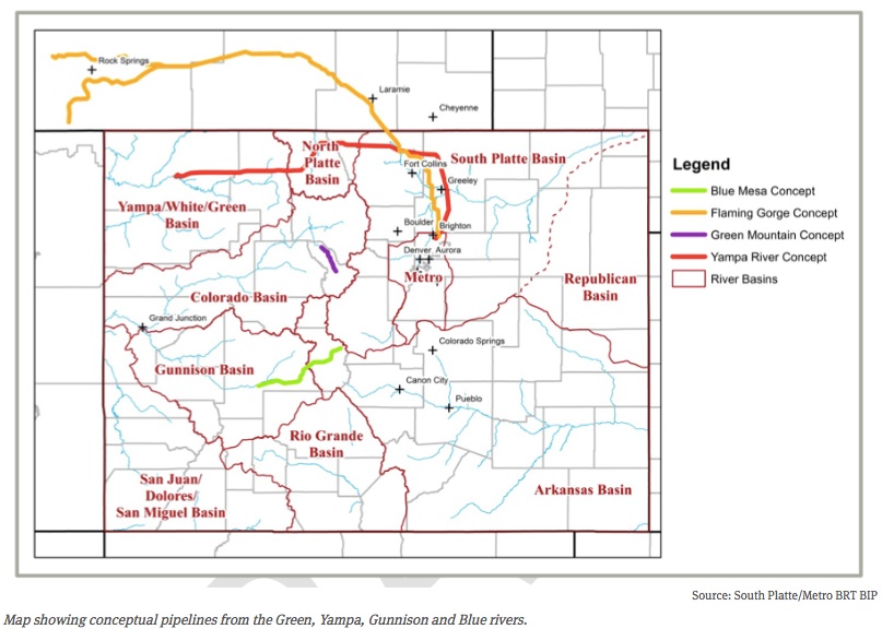
Letters sent to the Colorado Water Conservation Board in September about the draft Colorado Water Plan reveal a range of opinions about potential new transmountain diversions and the merits of using a “conceptual framework” to evaluate them.
Various Front Range water providers and interest groups told the CWCB that the conceptual framework should not be included in the water plan, should not be a regulatory requirement, and should not apply to transmountain diversion projects already in the planning and approval stage.
“Even with wording changes, the basin roundtables recommend that the CWCB not adopt the framework as it is a work in progress that may be modified as dialogue continues,” wrote the S. Platte and Metro basin roundtables, two of nine regional water-supply groups that meet under the auspices of the CWCB, in a combined Sept. 17 comment letter.
But a number of organizations based on the Western Slope or that focus on the Colorado River basin say the framework is a good step forward.
Officials at the Getches-Wilkinson Center for Natural Resources, Energy and the Environment at the University of Colorado Boulder, for example, gave an enthusiastic endorsement of the framework.
“This is a revolutionary document and a quantum leap forward in Colorado water history,” Lawerence MacDonnell and Anne Castle, both of the Getches-Wilkinson Center, wrote in a Sept. 17 letter to the CWCB. “The conceptual framework is a critically important part of the Colorado Water Plan and should be formally adopted in the plan and by the CWCB, not just monitored.”
The final water plan is expected to be approved by the CWCB board of directors at their meeting on Nov. 19 at the History Colorado Center in Denver.
The conceptual framework includes seven principles “to guide future negotiations between proponents of a new TMD and those communities who may be affected were it built.”
The concepts covered include a recognition that there may not be water to divert in dry years, that new diversions should not increase the likelihood of a compact call from California, that municipal conservation should also be pursued and that environmental needs must be addressed.
Brent Newman, a program manager in the water supply planning section of CWCB, said Friday that the framework is going to be included in the final water plan and will be called “Colorado’s Conceptual Framework.”
“Folks may not agree with every single principle, or even with discussing the concepts of a transmountain diversion out loud, but it represents a historic milestone in Colorado water policy that’s a long way from ‘Not One More Drop’ or ‘We’ll See You in Court,’” Newman said, citing the long-held positions of the Western Slope and the Front Range, respectively.
RANGE OF VIEWS
Comments on the second draft of the water plan were due Sept. 17 and water-focused organizations filed more than 50 substantive letters.
It’s not hard to pick up on the differing views in the letters about the framework, which was developed over the last two years by members of the Interbasin Compact Committee, which serves as an executive committee for the CWCB’s nine basin roundtables.
Those who don’t think new transmountain diversions are a good idea tend to support the framework. But those who see new diversions as necessary diminish the framework’s authority and reject its potential restrictions.
Castle and MacDonnell of the Getches-Wilkinson Center clearly support the framework, but they see big problems with taking more water from the upper Colorado River basin.
The pair told the CWCB that “development of significant new Colorado River supplies increases the risk of future curtailment to all existing, post-1922 Colorado River water users, reduces the production of renewable hydropower at Colorado River Storage Project reservoirs, and could ratchet up unwelcome and counterproductive political dynamics among the Colorado River basin states.”
But officials at Colorado Springs Utilities, while aware of potential issues with downstream water users in other states, see new TMDs as a likely necessity.
M. Patrick Wells, the managing engineer for water resource planning for CSU, told the CWCB in a Sept. 17 letter that the draft water plan “consistently overlooks the fact that one or more new TMDs will ultimately need to be constructed to address Colorado’s water supply gap.”
As such, Wells said the final water plan “should contain a definitive statement that a new TMD will be constructed, even if no formal concept has been proposed.”
Wells also said CSU has “a significant concern” that adhering to the framework will become a regulatory requirement of new water projects.
The utility “strongly requests” that language be added to the water plan to “make it abundantly clear that the conceptual framework is not a statement of state policy, and is not in any way to be interpreted or construed as a basis for any conditions or requirements in any water court case, state or federal permitting process, or contract negotiation.”
The members of the Front Range Water Council agree with Colorado Springs Utilities on this point.
In its Sept. 15 letter, the council pointed to recent remarks about the framework made by John McClow, a CWCB board member from the Gunnison River basin.
“As board member McClow stated in his remarks at the summer Colorado Water Congress convention, the framework has no regulatory force or effect. Rather, it is guidance, the implementation and use of which will depend on the positions taken by the parties who engage in good faith negotiations on the construction of future specific proposed projects.”
The council includes Denver Water, Aurora Water, Colorado Springs Utilities, Northern Water, the Southeastern Colorado Water Conservancy District, the Twin Lakes Reservoir and Canal Co., and the Board of Water Works of Pueblo.
MORE WATER EAST
A few organizations have told the CWCB that the framework should apply to both potential new transmountain diversions and the “firming” of existing transmountain water supplies.
Today, about 600,000 acre-feet of water a year is sent east under the Continental Divide and over 500,000 acre feet of that is diverted from headwaters in Grand, Summit, Eagle and Pitkin counties.
And another 120,000 to 140,000 acre-feet of water could be sent east after changes are made to existing transmountain diversion systems, according to the Colorado River basin roundtable.
Included in that 140,000 acre-feet figure is 20,000 acre-feet more from the Windy Gap project in Grand County, 18,000 acre-feet more from the Moffat Collection System above Winter Park, and 20,000 from the Eagle River MOU project, which potentially includes an expansion of Eagle Park Reservoir at the Climax Mine and a new dam and reservoir on lower Homestake Creek.
In addition to those, the water quality and quantity committee of the Northwest Colorado Council of Governments told the CWCB that there are other projects in the works that could send more water east, including “future Dillon Reservoir diversions, firming in the upper Roaring Fork and Fryingpan rivers, and Colorado Springs Utilities expanded diversions from the upper Blue River.”
In the language of the Colorado Water Plan, these projects already on the books are called IPPs, for “identified projects and processes.”
The Pitkin County commissioners, in a Sept. 15 letter, told the CWCB that the county “wholeheartedly endorses” the framework but “strongly believes” the framework’s core principles need to be “expanded in scope to apply equally to the various IPPs that involve trans-basin diversions.”
The Pitkin County Healthy Rivers and Streams Board, a tax-funded organization dedicated to leaving more water in the Roaring Fork River and its tributaries, feels the same way.
“The IPPs are the result of simple community canvassing to obtain information as to any potential plans or processes that are being contemplated around the state,” the board wrote in a Sept. 17 letter. “The IPPs have not been vetted and vary widely in size, impact and feasibility. “
SOME PLAIN LANGUAGE
Trout Unlimited, which has been paying close attention to the development of the water plan, said it supports the framework.
But it also gave the CWCB some plain-language criteria it thinks should be used to judge new TMDs.
“These transmountain diversions of water can cause severe economic and environmental damage to the areas of origin,” wrote Richard Van Gytenbeek, the Colorado River Basin outreach coordinator for Trout Unlimited, in a Sept. 17 letter to the CWCB.
As such, Gytenbeek told the CWCB it “should reject all new TMDs” unless the project proponent is already “employing high levels of conservation,” can show “that water is available for the project,” and “makes commitments that guarantee against environmental or economic harm to the basin of origin.”
The Colorado River District, which has board members from 15 Western Slope counties, said it supports the framework.
The river district’s general manager, Eric Kuhn, has been instrumental as a member of the IBCC in developing many of the framework’s key concepts.
“Admittedly, there are elements of the framework that we would prefer to edit but recognize there are others who would address those same edits in an opposite fashion,” the River District told the CWCB in a Sept. 17 memo.
However, the River District said the framework “represents a ‘way forward’ for constructive discussion about possible development of Colorado River basin water resources for out-of-basin use.”
Aspen Journalism is collaborating with the Post Independent and The Aspen Times and on coverage of statewide water issues. More at http://www.aspenjournalism.org…
SEVEN PRINCIPLES
1. East Slope water providers are not looking for firm yield from a new TMD and the project proponent would accept hydrologic risk for that project.
2. A new TMD would be used conjunctively with East Slope supplies, such as interruptible supply agreements, Denver Basin Aquifer resources, carry-over storage, terminal storage, drought restriction savings and other non-West Slope water sources.
3. In order to manage when a new TMD would be able to divert, triggers are needed. Triggers are operating parameters that determine when and how much water a potential new TMD could divert, based upon predetermined conditions within the Colorado River System.
4. A collaborative program that protects against involuntary curtailment is needed for existing uses and some reasonable increment of future development in the Colorado River System, but it will not cover a new TMD.
5. Future West Slope needs should be accommodated as part of a new TMD project.
6. Colorado will continue its commitment to improve conservation and reuse.
7: Environmental resiliency and recreational needs must be addressed both before and conjunctively with a new TMD.
Colorado transmountain diversions via the University of Colorado
Newly proposed legislation to reform the Land and Water Conservation Fund, which Congress allowed to expire at the end of September, is being met by criticism that it will radically alter the popular program.
House Natural Resources Committee Chairman Rob Bishop, R-Utah, who previously promised to put forward legislation that would change the LWCF’s funding after the program expired, announced the proposed legislation during a conference call earlier this week.
“More than 50 years ago, the Land and Water Conservation Fund was created to develop outdoor recreation facilities throughout the nation,” Bishop said during the call. “And while broadly supported and in many ways a policy success, the LWCF has strayed quite a bit beyond its law and original intent.”
The LWCF, which was first established in 1964, is the country’s most successful land conservation program. Over its history, the program has provided close to $17 billion in funding for the expansion of state and federal parks and national forests across the country.
Colorado Sens. Michael Bennet, a Democrat, and Cory Gardner, a Republican, have both expressed support for the fund’s permanent reauthorization.
In January, Bennet introduced legislation along with Sen. Kelly Ayotte, R-N.H., and Sen. Richard Burr, R-N.C., to permanently reauthorize the fund. That legislation garnered 59 votes, one short of the 60 needed to pass the Senate.
Bennet said that the current reforms proposed by Bishop are unnecessary.
“The LWCF is one of our country’s most successful conservation programs that has benefited urban and rural communities throughout Colorado,” Bennet said. “It does not need to be reformed, and it enjoys strong bipartisan support. We will continue to push for permanent reauthorization and will work to secure full funding for the program.”
Gardner, along with Bennet and 52 other senators, previously signed on to a letter to Senate Majority Leader Mitch McConnell, R-Ky., calling for the LWCF’s permanent reauthorization. Gardner also repeated his support for the program in response to Bishop’s legislation.
“For over 50 years, the LWCF has preserved iconic landscapes in Colorado and throughout the country,” he said. “I remain a strong proponent of permanently reauthorizing the LWCF, and that is why I will continue to work toward a solution that paves the way for the commonsense, permanent reauthorization of a program that has been a great friend to Colorado and is supported by sportsmen, hunters, recreationists and Americans around the country.”
Rep. Scott Tipton, R-Cortez, who previously said that the fund was in need of reform “to ensure it is still achieving its original mission,” has not yet publicly come out in favor of the proposed legislation.
“Congressman Tipton looks forward to carefully reviewing Chairman Bishop’s proposal,” said Tipton spokesman Josh Green.
The fossil-fuel industry—which, for two centuries, underwrote our civilization and then became its greatest threat—has started to take serious hits. At noon today [November 6, 2015], President Obama rejected the Keystone Pipeline, becoming the first world leader to turn down a major project on climate grounds. Eighteen hours earlier, New York’s Attorney General Eric Schneiderman announced that he’d issued subpoenas to Exxon, the richest and most profitable energy company in history, after substantial evidence emerged that it had deceived the world about climate change.
These moves don’t come out of the blue. They result from three things.
The first is a global movement that has multiplied many times in the past six years. Battling Keystone seemed utterly quixotic at first—when activists first launched a civil-disobedience campaign against the project, in the summer of 2011, more than ninety per cent of “energy insiders” in D.C. told a National Journal survey that they believed that President Obama would grant Transcanada a permit for the construction. But the conventional wisdom was upended by a relentless campaign carried on by hundreds of groups and millions of individual people (including http://350.org, the international climate-advocacy group I founded). It seemed that the President didn’t give a speech in those years without at least a small group waiting outside the hall to greet him with banners demanding that he reject the pipeline. And the Keystone rallying cry quickly spread to protests against other fossil-fuel projects. One industry executive summed it up nicely this spring, when he told a conference of his peers that they had to figure out how to stop the “Keystone-ization” of all their plans.
The second, related, cause is the relentless spread of a new logic about the planet—that we have five times as much carbon in our reserves as we can safely burn. While President Obama said today that Keystone was not “the express lane to climate disaster,” he also said that “we’re going to have to keep some fossil fuels in the ground rather than burn them.” This reflects an idea I wrote about in Rolling Stone three years ago; back then, it was new and a little bit fringe. But, this fall, the governor of the Bank of England, Mark Carney, speaking to members of the insurance industry at Lloyds of London, used precisely the same language to tell them that they faced a “huge risk” from “unburnable carbon” that would become “stranded assets.” No one’s argued with the math, and that math indicates that the business plans of the fossil-fuel giants are no longer sane. Word is spreading: portfolios and endowments worth a total of $2.6 trillion in assets have begun to divest from fossil fuels. The smart money is heading elsewhere.
Which brings us to the third cause. There is, now, an elsewhere to head. In the past six years, the price of a solar panel has fallen by eighty per cent. [ed. emphasis mine] For years, the fossil-fuel industry has labored to sell the idea that a transition to renewable energy would necessarily be painfully slow—that it would take decades before anything fundamental started to shift. Inevitability was their shield, but no longer. If we wanted to transform our energy supply, we clearly could, though it would require an enormous global effort.
Don’t you just love renewable energy capital markets moving the polluters out of the picture?
Here’s a report about the impending bankruptcy of Arch Coal from Elizabeth Shogren writing for The High Country News. Here’s an excerpt:
There’s no question that the president’s Clean Power Plan and his other air pollution regulations cloud the future of the industry. But coal’s bleak present has much more to do with other factors; chief among them the low price of natural gas and bad business decisions that the country’s biggest coal companies made in recent years. “These are undoubtedly difficult, if not unprecedented, times for the coal sector,” Glenn Kellow, chief executive officer of Peabody, the world’s largest coal company, reportedly said on the company’s recent earnings call.
Both Arch Coal and Peabody Energy paid billions of dollars to acquire metallurgical coal mines when prices of this type of coal, which is used to make steel and other metals, were soaring. The price has since collapsed, leaving the companies swamped in debt and their stock prices a small fraction of what they used to be. In Arch’s case, it spent $3.4 billion in 2011 to buy International Coal Group, Inc., acquiring 13 mines in the eastern United States. At the time, the only company more invested in metallurgical coal was Alpha National Resources, (remember that name), which was buying Massie Energy for $7.1 billion. That same year, Peabody shelled out $5.2 billion for metallurgical coal mines in Australia.
The companies borrowed to buy these metallurgical coal mines, with the expectation that Asia, especially China, would gobble up all the metallurgical coal they could produce. What they didn’t count on was the price of metallurgical coal spiraling downward due in part to increased supplies of metallurgical coal from other countries and slower growth in China. Now U.S. metallurgical coal sells for less than half what it did in 2011.
Arch’s debt comes due next year. Scrambling to avoid bankruptcy, Arch tried to get creditors to renegotiate its debt, but the effort collapsed at the end of last month. Peabody has until 2018, and yet its stock has fallen from more than $1,000 in 2011 to less than $13 this fall.
The West is largely a bystander to this high drama, except that the companies that produce the most coal in the West are caught in the middle of it. Profitable mines owned by these companies in Wyoming’s Powder River Basin likely still will operate under whatever slimmed-down companies emerge from bankruptcy or under new ownership. But underground mines, where it costs more to extract the coal, may be less lucky. Peabody’s Twentymile mine in northwestern Colorado reportedly already has experienced significant reductions in production.
Mines in the West are not immune from the other main factor vexing the coal industry: low natural gas prices. Coal’s share in electricity production dropped from 50 percent in 2005 to 39 percent in 2014, and natural gas overtook coal as the biggest electricity producer for two months this year. The Energy Information Agency expects an 8 percent decrease in total coal consumption in 2015 compared to 2014, mainly driven by electric companies shifting to low-cost natural gas. Retirement of coal-fired power plants due to the Obama administration’s Mercury and Air Toxics Standards contributed, but to a lesser degree, according to the Energy Information Agency. “The big story here is gas and how cheap it is,” says Robert Godby, associate economics professor at the University of Wyoming who focuses on coal.
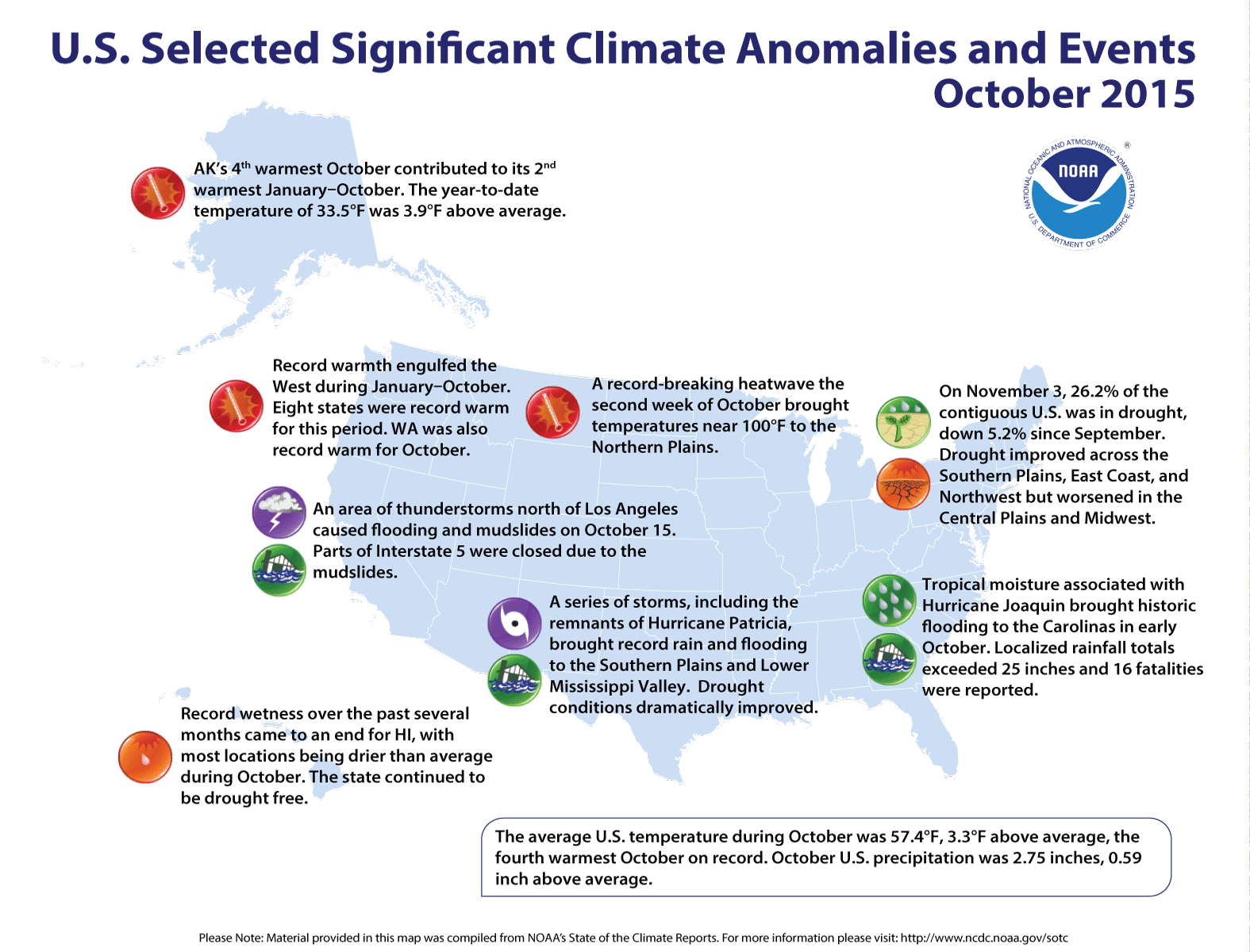
Click here to go to the NOAA website. Here’s an excerpt:
U.S. climate highlights: October
Temperature
Fourteen states from the Great Plains to West Coast, including Alaska, had an October temperature that was much above average, with numerous locations within those states being record warm. Washington had its warmest October on record with a temperature of 52.8°F, 5.6°F above average, besting the previous record of 52.3°F set in 1988.
Near-average October temperatures were observed across the Ohio Valley, Southeast, and Northeast, with below-average temperatures in parts of New England.
Precipitation
Above-average precipitation was observed across the southern half of the contiguous U.S. from the Southwest, through the Southern Plains, and into the Southeast. Seven states had October precipitation totals that were much above average. South Carolina had its second wettest October with 10.36 inches of precipitation, 7.37 inches above average.
Only October 1990 was wetter for the state when 11.56 inches of precipitation was recorded.
Below-average October precipitation was recorded in parts of the Northwest, Ohio Valley, and Florida.
According to the November 3rd U.S. Drought Monitor report, 26.2 percent of the contiguous U.S. was in drought, down about 5.2 percent compared to September 29th. Drought conditions dramatically improved across parts of the Southern Plains and Lower Mississippi River Valley where heavy precipitation flooded the region in late October. Drought also improved across the Southeast and in parts of the Northwest. Drought conditions worsened across parts of the Central Plains and Midwest. Precipitation was spotty across the West with long-term drought conditions continuing to plague the region.
Significant Events
In early October, a strong low pressure system moved into the Southeast as Hurricane Joaquin moved off the East Coast. The two systems interacted, streaming deep tropical moisture into the Carolinas over a five-day period. Historic rainfall totals of 15-20 inches were widespread with localized totals greater than 25 inches around Charleston, South Carolina. The heavy rainfall caused significant flooding across the region, including coastal flooding that was exacerbated by strong onshore flow and astronomical high tides. The flooding resulted in over 400 roads, including Interstate Highways, being closed and at least 16 fatalities.
In late October, several storm systems impacted the Southern Plains and Lower Mississippi River Valley, including the remnants of Hurricane Patricia. Heavy rainfall caused significant flooding across the region. On October 30th, Austin, Texas’s Bergstrom Airport was forced to close when 5.76 inches of rainfall was observed in one hour, adding to the calendar-day total of 14.99 inches. This was the second wettest day on record for the city. Texas as a whole had its fifth wettest October with 5.84 inches of precipitation, 3.31 inches above the 20th century average.
For the historical moment, it appears, there will be no continent-spanning death funnel bringing the world’s dirtiest fossil fuel from the environmental hellspout of northern Alberta down through the most arable farmland in the world to the refineries of the Gulf Coast, thence to the world. The president has decided this will not be the case…
You could see it coming over the last month—when Canadian elections went against the death funnel’s primary political supporters, both nationally and in Alberta. You could see it when TransCanada, the multinational corporation seeking to build the death funnel, begged the State Department for a reprieve that would have pushed the decision to approve the tunnel past the end of the current president’s term. You could see it this week, when the State Department refused to honor that request. But the real story of what happened on Friday begins years ago, and it begins with ordinary people, and it is a remarkable story of actual populism in action.
George Washington addresses the Continental Congress via Son of the South FromThe Boulder Weekly (Matt Cortina):
There was an effort by half of the state’s Water Resources Review Committee last week to approve two bills that would have taken the permitting process for new dams and reservoirs away from federal and state regulatory agencies like the Environmental Protection Agency (EPA), the U.S. Army Corps of Engineers and other wildlife and public health agencies and given all dam and reservoir permit decisions solely to the Office of the State Engineer.
The first draft bill essentially intended to strip the rights of state regulators, including the state energy office, the water quality control division, the parks and wildlife commission and more from making decisions about any hydroelectric energy facility (dams); certification for water diversion, delivery and storage facilities (reservoirs); and state mitigation plans for water diversions that affect fish and wildlife.
The second draft bill sought to strip federal regulators, like the EPA, the Army Corp of Engineers, the Bureau of Reclamation and others, from permitting on water issues and resources done at the federal level.
Both bills would have consolidated all that regulation and decision-making to the Colorado Office of the State Engineer, otherwise known as the Division of Water Resources.
The bills were brought forth by Rep. Jerry Sonnenberg (R-Wray) and were heard on Oct. 29 in the committee. The 10-member committee voted along party lines, and with an even split of Republicans voting for and Democrats voting against the bills, both quickly died — for now.
The bills could still be presented to the state legislature by Sonnenberg or another legislative member when the new session convenes in January. Given the split state legislature, which has been the cause of death for many bills, it’s unlikely the bills would gain any traction, but their introduction in the committee might represent a much larger push by some on the right to limit permitting regulation on water issues…
To those in the know about Colorado’s water issues, the suggestion of condensing all permitting powers to one office seems ludicrous. But the case made for these bills is likely to appeal to a large segment, particularly those who lean right, of Coloradans: less federal regulation, less state bureaucracy around permitting and a secure source of water for the state…
The state’s grand water regulation plan, Colorado’s Water Plan, is the product of an executive order by Gov. John Hickenlooper, and will manifest as a final draft in December. The plan will include a more “efficient permitting process,” and the latest draft calls for the solicitation of private funds to help build new water supply projects that have yet to be determined.
Governor Hickenlooper and James Eklund at the roll out of the Colorado Water Plan December 11, 2014 via The Durango Herald
FromThe Grand Junction Daily Sentinel (Gary Harmon):
Building a transmountain diversion in Colorado is one thing — 11 on a difficulty scale of 5 — but increasing water storage might be far easier, the head of the Colorado Water Conservation Board said.
The board is nearing completion of the state’s first water plan, which Gov. John Hickenlooper ordered drawn up in 2013 to address a water-supply gap of 560,000 acre-feet of water by 2050. For perspective, the state’s largest impoundment, Blue Mesa Reservoir, contains about 830,000 acre-feet when full.
As the drafters have tackled the storage section of the plan, it’s become clear that the state could increase its water storage significantly simply by looking anew at existing dams, water official James Eklund said.
There are “about 100,000 acre-feet that could be snatched up pretty quickly” without so much as turning a shovel, Eklund said.
Many dams were originally constructed in an abundance of caution to contain more water than they actually have, Eklund said.
Taking the additional storage into account “could produce a new chunk of water” that could be held back in reservoirs, Eklund said.
Eklund is to unveil the entire plan Nov. 19 at History Colorado in Denver, just under a month ahead of schedule. It was ordered to be complete by Dec. 10.
The plan will contain several objectives that, if reached, would move the state toward filling the gap between the demands of 5 million more Coloradans by 2050 and the amount of water available within the state.
Among the goals are increasing municipal and industrial conservation by 400,000 acre-feet per year and boosting to 50,000 acre-feet annually the amount of water involved in voluntary alternative transfer projects, up from 3,000 acre-feet annually now.
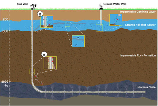
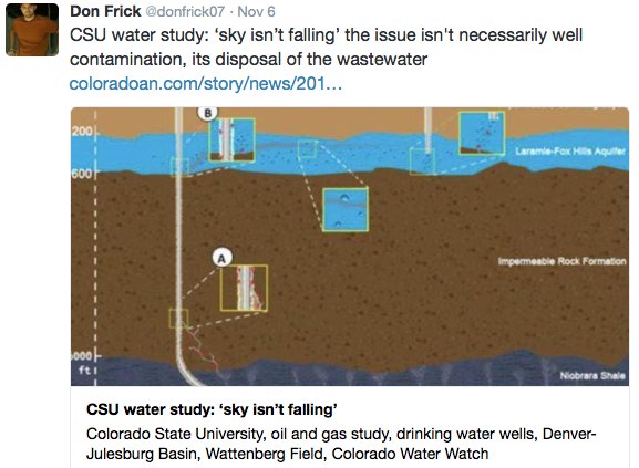
A schematic of possible migration pathways of contaminants, water-based and gas-phase, into the bedrock aquifer from adjacent faulty oil or gas wells via Colorado State University
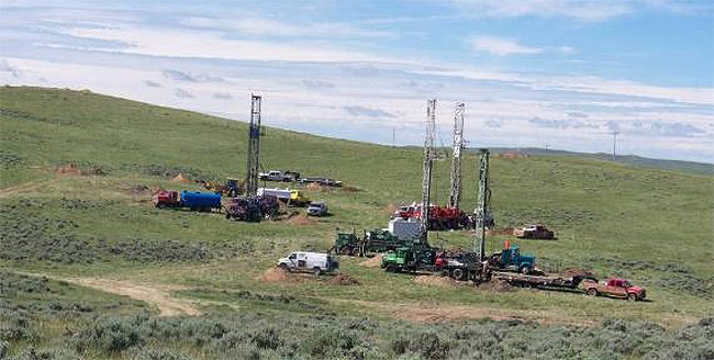
There’s no evidence of water-based contaminants seeping into drinking water wells atop a vast oil and gas field in northeastern Colorado, according to Colorado State University scientists working to protect and inform citizens about the safety of their water.
Ken Carlson, professor of civil and environmental engineering, has led a series of studies analyzing the impact of oil and gas drilling on groundwater in the 6,700-square-mile Denver-Julesburg Basin, which extends north-south from Greeley to Colorado Springs, and east-west from Limon to the foothills.
The studies have been performed under the auspices of the Colorado Water Watch, a state-funded effort begun last year for real-time groundwater monitoring in the Denver-Julesburg Basin. The basin shares space with more than 30,000 active or abandoned oil and/or natural gas wells. The CSU researchers primarily looked at the 24,000 producing and 7,500 abandoned wells in the Wattenberg Field, which sits mainly in Weld County.
Niobrara Shale Denver Julesberg Basin
“We feel that our results add to our database of knowledge,” Carlson said. “There isn’t a chronic, the-sky-is-falling type of problem with water contamination.”
That isn’t to say that some of the water wells in the basin over the Wattenberg oil and gas field aren’t compromised. Carlson’s team found that 2 percent of their sampled wells showed seepage of oil- and gas-related methane – a flammable greenhouse gas that’s the main component in natural gas.
And that’s not good, Carlson said. Methane, a concern for climate change emissions, can also be explosive (which is why coal mines blow up, and why the movie “Gasland” portrayed flaming taps). But it’s not toxic, and isn’t a huge factor in terms of drinking water safety. It also is found in large quantities in the basin from naturally occurring, biogenic sources.
With regard to the really bad stuff – the bariums, chromiums and other soluble contaminants that people have been worried about getting into their water – Carlson’s team didn’t find any.
Their studies strengthen the theory that thermogenic (originating from oil and gas formations) methane contamination is most likely due to stray gas moving along the outside of compromised well casings in and around the aquifers. Well casings are the cement and steel housing around the production tubing of the oil rig. That tubing penetrates the ground, straight through the aquifer, and into the oil- and gas-rich sediment thousands of feet below.
“My guess is that most of the thermogenic methane-contaminated wells we see out there are 10 to 30 years old,” Carlson said. “Well casing requirements and monitoring have tightened up significantly since the 2009 regulations.”
A series of studies, led by CSU civil and environmental engineer professor Ken Carlson, analyzed the impact of oil and gas drilling on groundwater in the 6,700-square-mile Denver-Julesburg Basin, which extends between Greeley and Colorado Springs and between Limon and the foothills.
The studies were done under the auspices of the Colorado Water Watch, a state-funded effort started last year for real-time groundwater monitoring in the DJ Basin. The basin shares space with more than 30,000 active or abandoned oil and natural gas wells, say CSU researchers.
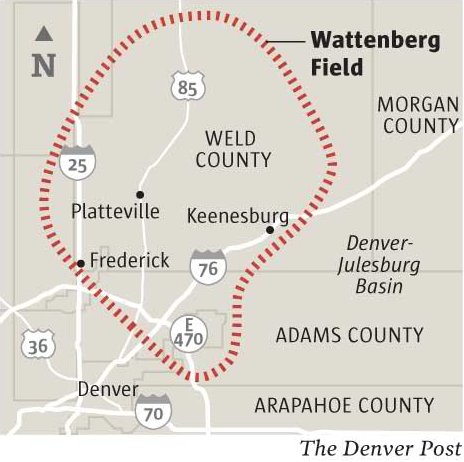
Wattenburg Field via The Denver Post
They primarily looked at the 24,000 producing and 7,500 abandoned wells in the Wattenberg Field, which sits mainly in Weld County.
“We feel that our results add to our database of knowledge,” Carlson said. “There isn’t a chronic, the-sky-is-falling type of problem with water contamination.”
Still, some of the water wells in the basin over the Wattenberg field are compromised, says CSU. Carlson’s team found that 2 percent of their sampled wells showed seepage of oil- and gas-related methane — a flammable greenhouse gas that’s the main component of natural gas.
Methane, in addition to being a concern for climate change emissions, can also be explosive. Still, it’s not toxic and isn’t a huge factor in terms of drinking-water safety.
But other worrisome soluble contaminants — including barium and chromium — were not found by Carlson’s team.
They say that strengthens the theory that thermogenic — that which originates from oil and gas formations — methane contamination is most likely due to stray gas moving along the outside of compromised well casings in and around aquifers.
The issue: “…it’s disposal of wastewater.” — Don Frick
From the Loveland Reporter-Herald (Pamela Johnson):
Customers within the Little Thompson Water District, including three local schools, have been notified of elevated levels of lead discovered during recent water testing.
The water district tested 16 taps from its customers in September, and one of those revealed enough lead that the district notified all customers of the result and precautions they can take to be safe. The levels were not high enough to violate drinking water standards or require additional action.
“The risk is on a house by house basis depending upon how much lead they have in their plumbing system,” explained Ken Lambrecht, operations manager for the district.
“It happens when the water sits in the home plumbing.”
Both the Little Thompson and the Central Weld Water Districts receive their water from the Carter Lake Filter Plant, so they test their samples together.
The districts submitted 33 total samples in September, 16 from Little Thompson and 17 from Weld. Of those, one Little Thompson site and 5 Weld sites tested above 15 micrograms per liter of lead, requiring them to notify all customers and offer education about lead. The Little Thompson reading was 21.7 micrograms per liter, while the highest in Weld was 31.9.
To lower lead levels, the districts have implemented a new procedure whereby a substance named poly-orthophosphate is added to the water, Lambrecht said. This coats the pipes so any lead within them cannot leach into the water and affect customers, he said…
Steps to reduce lead
The Little Thompson Water District offers the following advice for reducing the risk of lead exposure in water:
Flush out the system by running the cold water until it is noticeably colder if you haven’t had the water running for several hours. Save the water for plants or cleaning.
Always use cold water for drinking, cooking and preparing baby formula. (Note: Boiling water does not reduce lead.)
Periodically remove and clean the faucet’s strainer and aerator and run water to remove debris.
Identify and replace plumbing fixtures containing lead.
Consider installing a water treatment device.
Have a licensed electrician check your home’s wiring because, if grounding wires are attached to pipes, the risk of corrosion may increase.
We know that the boat is definitely pointed in the right direction. We look forward to participating in the plan’s implementation so future water decisions continue to reflect the values and priorities outlined in the plan.
We are pleased to see the plan include many of the points Coloradoans have expressed overwhelmingly—through more than 30,000 public comments submitted to the state—including a strong statewide urban conservation goal and proposed funding for healthy rivers and streams across our state.
Over the next year, we urge the CWCB and the Hickenlooper administration to maintain this positive momentum to ensure there will be inclusive implementation, specific, stringent criteria for project selection and adequate funding to protect our rivers, outdoor recreation industry, agricultural heritage, and thriving cities.
Colorado Water Plan website screen shot November 1, 2013
Bill Reforms 1872 Mining Law to Help Prevent Future Disasters like Gold King Mine Blowout
Washington, DC – U.S. Senators Michael Bennet (D-CO), Tom Udall (D-NM), and Martin Heinrich (D-NM) along with Senators Ron Wyden (D-OR) and Edward Markey (D-MA) introduced a bill to reform the nation’s antiquated hardrock mining laws. The Hardrock Mining and Reclamation Act of 2015 will ensure mining companies pay royalties for the privilege of extracting mineral resources from public lands.
The bill helps ensure that taxpayers aren’t on the hook for cleaning up abandoned mines, many of which are continuously leaking toxic chemicals into rivers and streams and have the potential for catastrophic disasters like the recent Gold King Mine blowout. The Gold King Mine accident spilled 3 million gallons of toxic wastewater into the Animas and San Juan rivers, and communities in New Mexico and Colorado are still struggling to recover from the impact to businesses, farms, and local governments.
Current mining law dates back to 1872 and allows companies to take gold, silver, copper, uranium and other minerals from public land without paying any royalties. The lawmakers’ bill would impose a commonsense royalty – similar to that paid by oil and gas and coal companies for decades – to help pay for abandoned mine cleanup and prevent future disasters. There are up to 500,000 abandoned mines across the West, and cleanup is estimated to cost tens of billions of dollars.
In Colorado alone, there are an estimated 7,100 abandoned mines, including 200 that are leaking thousands of gallons of acid mine drainage per minute, which is equal to at least one Gold King disaster every two days. More than 1,600 miles of the San Juan, Big Thompson, Rio Grande, Mancos, and Arkansas River drainages are affected by untreated mines.
“Three months ago, the Gold King Mine spill provided a sudden and devastating reminder of the dangers that abandoned mines pose in Colorado and across the West,” Bennet said. “Mining has been intrinsically linked to our history, economy, development and culture, but it’s also left scars across Colorado and other states. More than 200 mines in Colorado are leaking acid mine drainage that is polluting headwaters and affecting water quality for communities downstream. Our bill will help clean up these mines and prevent the possibility of future tragedies like the Gold King Mine.”
“Hardrock mining companies have enjoyed a sweetheart deal for nearly 150 years, leaving taxpayers on the hook to clean up hundreds of thousands of abandoned mines leaking toxins and threatening communities across the West,” said Udall, who has pushed for mining reform since he was first elected to the U.S. House of Representatives in 1998 and passed a unanimous amendment to the Fiscal Year 2013 budget resolution calling on Congress to enact a royalty for mining on public lands. “The Gold King Mine blowout proves that the status quo just isn’t working, and New Mexico and Navajo Nation communities are suffering the consequences. Gold and silver on public lands are a natural resource, just like oil and gas. Taxpayers deserve their fair share of the profit – and communities across the West need that money to clean up abandoned mines.”
“Disastrous spills like the Gold King Mine blowout are easy to see. But the unnoticed toxins leaking out of thousands of abandoned gold, silver, copper, and uranium mines are doing enormous damage to our watersheds every day,” said Heinrich, who recently toured uranium legacy sites in the Navajo Nation. “We must come together and pass commonsense reforms to our outdated and ineffective federal policy on abandoned mines and hardrock mining.”
The Hardrock Mining and Reclamation Act of 2015 will:
Set a 2 to 5 percent royalty rate for new mining operations, based on gross income on production.
Use royalty revenue and a separate fee of 0.6 to 2 percent to pay for abandoned mine cleanup.
Allow states and tribes to receive funding for hardrock reclamation programs, and establish a grant program for other organizations that want to carry out restoration projects.
Require permits for non-casual exploration and mining on federal land, and outline requirements for a permit like avoiding acid mine drainage.
Require annual rental payments for claimed public land, thereby permanently eliminating patenting and characterizing mine operators as other public land users.
Give the Secretary of the Interior the authority to grant royalty relief if economic factors require it.
Permit states and tribes to petition the Secretary of the Interior to withdraw lands from mining, and require an expedited review of certain lands to determine whether they are appropriate for future mining.
“After you see something like this spill into the Animas River, a policy of sitting on our hands and doing nothing is just unacceptable,” Bennet said during the call.
The new legislation, known as the Hardrock Mining and Reclamation Act of 2015, will make mining companies pay for royalties for extracting resources from public lands. The money would be used to help clean up abandoned mines that are continuing to leak waste into waterways, and ensure that future spills like the Gold King Mine disaster are not rectified at the expense of taxpayers.
“In the Southwest, water is simply our most precious resource, so you can imagine what kind of impact the Gold King mine spill had on our community,” Heinrich said…
Bennet and his colleagues agreed that it was time for the hardrock mining industry to pay its fair share. They pointed out that the royalty fees on the mining industry would be a fraction of the coal, oil and gas industry’s rate of 12½ percent.
“Every other extractive industry pays royalties,” Bennet said. “Hardrock mining companies should pay as well.”
Bennet added that Colorado has already spent $12 million over the last few years to clean up some of the more serious leaks. The EPA estimates that 230 mines in Colorado are currently leaking toxic chemicals into the state’s waterways, and that it would cost tens of billions of dollars to effectively clean up all mines in the west.
The proposed bill would serve as the first major change to The General Mining Act of 1872 since it first became law. The Mining Act, passed 143 years ago, continues to govern mining operations on public lands and allows companies to extract minerals from these grounds royalty-free.
Luján is the cosponsor of a similar mining reform bill that’s already been introduced in the House.
Western senators weighed in on the toxic mines problem Thursday, launching legislation to reform the nation’s 1872 Mining Law and require companies to pay fees to create a cleanup fund for abandoned inactive mines.
The legislation introduced by Colorado Sen. Michael Bennet and New Mexico Sens. Martin Heinrich and Tom Udall would apply to existing and new mining operations. It aims to raise at least $100 million a year.
The idea is to create a new path — beyond “superfund” responses to environmental disasters — to begin to clean up tens of thousands of inactive mines in western states that continue to taint headwaters of the nation’s rivers. These include an estimated 230 sites in Colorado where state officials have documented bit-by-bit degradation of waterways.
Colorado Gov. John Hickenlooper recently said that cleaning up abandoned inactive mines just in Colorado would cost billions of dollars.
Congress has been giving greater attention to the problem after the Aug. 5 Gold King Mine disaster in southwestern Colorado above Silverton, where an EPA crew triggered a deluge of 3 million gallons of mustard-yellow liquid that worsened contamination of the Animas River.
U.S. Sen. Tom Udall, D-N.M., introduced legislation Thursday that would impose a federal minerals royalty, establish a reclamation fund for the cleanup of abandoned mines and require a review of lands to determine if those areas are available for future mining.
The Hardrock Mining and Reclamation Act of 2015 comes three months after the Gold King Mine spill released more than 3 million gallons of heavy metals-laden wastewater into the Animas and San Juan rivers.
The bill proposes authorizing the U.S. Department of the Interior secretary to determine royalty rates for new mining operations.
The rate for new mining would be based on the market value of the mineral being extracted and set a 2 to 5 percent rate based on the gross income of production on federal land.
The bill would also set a separate fee of 0.6 to 2 percent to pay for an abandoned mine cleanup.
Collected revenues would be deposited into the proposed Hardrock Minerals Reclamation Fund, which would be administered by the Interior Department, for distribution to federal agencies, states and tribes as long as they have a federally approved reclamation plan.
The bill also establishes a grant program the Interior Department could use to provide funds to organizations for cleanup activities…
Luján is a cosponsor of a similar measure that has been introduced in the U.S. House of Representatives.
“The Gold King Mine is part of a much larger problem,” Udall said. “The accident should be a wake-up call to Congress about the dangers we face.”
Among the dangers is the level of toxins released by abandoned mines that end up in watersheds and rivers that supply communities throughout the West, Udall said.
Under current law, mining companies — aside from coal, oil and gas — do not pay for the damages they cause, and taxpayers carry the burden, he added.
“Mining companies have enjoyed a sweetheart deal for far too long,” Udall said.
Heinrich said there are estimates that 40 percent of watersheds in the West are polluted by toxic mining waste, and reclamation could cost more than $1 billion.
This reform is a way to address that issue, he said.
Days after the spill, federal lawmakers visited the impacted areas, including Aztec, Farmington and the Navajo Nation.
“I think we all share the anger and frustration that was seen in the faces of our constituents,” Heinrich said.
In terms of the Navajo Nation, Heinrich said he and Udall have been talking to tribal officials about the bill.
“Those talks are ongoing, and, as you can imagine, they’re very interested in this proposal,” Heinrich said.
Bennet said the mining activities under the 1872 law have left the West with scars. In Colorado, there are an estimated 7,100 abandoned mines with more than 200 of them leaking acid mine drainage, Bennet said.
The state has spent $12 million over the last six years to clean up abandoned mines, but only three to four projects are addressed each year, he added.
This is not the first attempt at reforming the nation’s mining law. The most recent attempt came in 2007, and it was passed by the House but never passed by the Senate.
Udall said the group hopes all stakeholders will be open to examining the bill and working on its passage, but so far the legislation does not have support from Republicans.
“We are willing and able and working hard on building bipartisan support on this bill,” Udall said.
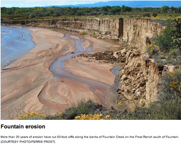
Fountain Creek erosion via The Pueblo Chieftain FromThe Pueblo Chieftain (Chris Woodka):
Pueblo officials are encouraged that Colorado Springs voters overwhelmingly passed a sales tax Tuesday to improve roads, saying it should keep the city to the north on track to fulfill its obligation to control stormwater on Fountain Creek.
“I’m glad it passed, but the proof is in the pudding,” said Jay Winner, general manager of the Lower Arkansas Valley Water Conservancy District. “Colorado Springs is doing the right thing, and a lot of the credit goes to (Mayor) John Suthers.”
The Lower Ark teed up a federal lawsuit over violation of the Clean Water Act following years of foot-dragging on the stormwater issue. Prior to Suthers’ election in May, the former Mayor Steve Bach resisted efforts to find a permanent source for stormwater control funding. Bach campaigned against creating a regional drainage district that failed in a vote last year.
Shortly after taking office, Suthers and Colorado Springs City Council President Merv Bennett gave assurances to Pueblo City Council that $19 million annually would be funneled into stormwater control. Opponents of the street tax suggested that the money targeted for stormwater could be used for streets instead.
Voters disagreed, passing the sales tax by a 65-35 margin. The 0.62 percent tax is expected to generate $260 million over the next five years for Colorado Springs streets.
“I never had any doubt they would do everything they could to get it passed,” said Pueblo City Council President Steve Nawrocki, praising the leadership of Suthers and Bennett. “This gives me a lot of confidence. We plan to meet with (Colorado Springs City Council) more often as we pursue this in the future.”
“I’m very pleased voters passed the roads tax measure,” Pueblo County Commissioner Terry Hart said. “It takes care of one of their two major infrastructure problems and frees up money for stormwater.”
All were inspired in different ways by the Colorado Springs vote.
For Winner, it could mean better reception for partnerships between the Lower Ark district and Colorado Springs. While they have worked together on Fountain Creek issues, the Lower Ark has also pushed for agreements on things such as Super Ditch and conservation easements.
“I think once the leadership within Colorado Springs Utilities has stabilized, we will be able to again have productive discussions,” Winner said. Hart said it paves the way for clearer negotiations over the remaining issues in the 1041 permit for Southern Delivery System.
“It makes it easier because traditionally streets have been a competing need with stormwater. This pays for that competing need,” Hart said.
For Nawrocki, it’s more of a call to look inward, and attempt to pass a tax similar to Colorado Springs to address infrastructure needs, including streets, in Pueblo.
“As president of City Council, I am interested in finding a funding source to do those sorts of things here in Pueblo,” Nawrocki said.
Click here to go to the US Drought Monitor website. Here’s an excerpt:
Summary
A series of storm systems swept across the lower 48 States, generating wet weather that soaked many portions of the contiguous U.S., including a second round of heavy rains that provided drought improvement and relief to the southern Great Plains and Mississippi Delta. Unfortunately, the rains were accompanied by severe weather and flash flooding in Texas, including a record daily total of 14.99 inches at Austin (5.76 inches in one hour) on October 30, and an EF2 tornado in Floresville that damaged the high school. Additional dryness or drought relief from moderate to heavy rains (more than 2 inches) also occurred across most of the Southeast, west-central Corn Belt and western Great Lakes region, Ohio and Tennessee Valleys, much of the Atlantic Coast States, and the Pacific Northwest, northern Rockies, and Sierra Nevada. Heavy precipitation also fell on interior and northeastern Puerto Rico and along the southeastern Alaskan Panhandle. Weekly temperatures generally averaged above to much-above normal in the lower 48 States, with near to below-normal readings limited from the Southwest northeastward into the middle Mississippi Valley, and in interior New England…
California and Great Basin
An early-season, moisture-laden Pacific storm system brought beneficial precipitation (including snows to higher elevations) to extreme northwestern and central California, including 2-3.5 inches of precipitation to the Sierra Nevada and northeastward across west-central and northeastern Nevada. The precipitation (and snow) was an early bonus to the 2015-16 Water Year in the Sierras, but with 4 consecutive years of drought, this precipitation was just a start to moisten the soils for hopefully more (frozen preferred) precipitation this winter, thus no changes were made in the Sierras. However, according to the NRCS Snotel sites, it was refreshing to see the Sierra average basins WYTD (since Oct. 1) precipitation and snow water content at 152-170% of normal and 608-1150% of normal, respectively, as of Nov. 3, but one must remember that normal are quite small early in the Water Year, so huge percentages can occur with a wet start (but better wet than dry). Additionally, the Impact Lines were redrawn to reflect where recent wetness has occurred (L only) versus where much-below normal short-term precipitation was recorded (SL).
In contrast, the past 6 months have been unusually wet in parts of the semi-arid Great Basin (200-300% of normal precipitation, surpluses of 4-8 inches), especially in extreme eastern California (east of Sierra range) and western Nevada. This has led to minimal fall wild fires, decent pasture and range conditions, and adequate soil moisture. Although the Nevada statewide reservoir levels were still dismal (Oct. 1: at 5% capacity, normal=35%) and will require ample mountain snowpack this winter, the past 6 months wetness (from all tools) in a semi-arid environment is significant and a good start to the 2015-16 Water Year. Therefore, D4 was improved to D3 in western Nevada (southwest Pershing, northwest and southern Churchill, southern Lyon, and western Mineral counties) and eastern California (northern Mono county) to reflect this recent moisture. In addition, some D3 to D2 improvement was made farther south along the CA-NV border (southern Nye and east-central Inyo counties) where the past 3-6 months have NOT been arid…
Mississippi Delta and Southern Plains
Extreme precipitation events seem to be the norm in this region as a sudden (1-2 weeks) end to the 3-month flash drought neared reality. Two swaths of copious rains (more than 8 inches), one between San Antonio and Austin, TX, and another from Houston, TX, to north of Alexandria, LA, produced flash and river flooding, with at least 5 fatalities in Texas. Needless to say, after the previous week’s rainfall, these amounts were more than enough to eliminate the remaining D1 and D0 across south-central and southeastern Texas and the southern two-thirds of Louisiana. In addition to these incredible totals, widespread moderate to heavy rains (2-6 inches) were measured across the eastern two-thirds of the state, south-central Oklahoma, central Arkansas, nearly all of Louisiana and the southern two-thirds of Mississippi. A widespread 1- to occasionally 2-category improvement was made in these areas as all D2 was removed. According to the Texas Water Development Board, statewide reservoirs stood at 82.1% full as of Nov. 4, continuing to climb after falling from 85% to 77% full during the flash drought. In addition, the Texas state climatologist John Nielsen-Gammon estimated that October 2015 statewide precipitation stood at 6.51 inches (previous Oct. record 6.26 inches in 1919), making 2015 the third year with at least two monthly records (May and October). The other two years were 2004 (June and November) and 2007 (March and July). Short to very short topsoil moisture dropped to 16, 19, 5, and 16% in Texas, Arkansas, Louisiana, and Mississippi, respectively, as of Nov. 1, down from 32, 48, 39, and 58% the previous week, according to NASS/USDA. Residual areas of D1 and D0 remained where 2-week precipitation totals were lower and larger 90-day deficiencies remained, however, the numerous reports of drought impacts a few weeks ago have instead turned to excessive moisture problems…
Northern and Central Plains
Weekly totals were much lower across the northern and central Plains as compared to areas to the south and east; however, in North Dakota, timely rains (0.2-0.7 inches) helped improve the condition of the winter wheat while farmers utilized the dry weather to continue harvesting corn and sunflower seeds which were done well ahead of normal. Even though little or no rain fell on South Dakota, 90-day surpluses, lower temperatures, and minimal evapotranspiration have kept the D0(S) from worsening. In southern Nebraska and eastern Kansas, light to moderate (0.3-0.9 inches) rains generally kept conditions stable, although a reassessment of short-term tools led to a slight redraw of the D1 areas in Kansas and D0 in southwestern Nebraska. In [southeastern] Colorado and southwestern Kansas, 0.6-1.5 inches of rain, locally to 2.5 inches, plus heavy rains from last week, were enough to eliminate the D0 in Kiowa, Cheyenne, and Prowers counties (Colorado), and Greeley and Hamilton counties (Kansas)…
Pacific Northwest and Northern Rockies
A constant barrage of Pacific moisture and storm systems brought daily precipitation, quite heavy during mid-week, to coastal Washington, northwestern Oregon, the northern Cascades, and northern Rockies. For the week, totals ranged between 6-15 inches in the first three areas, and 2-6 inches in the latter region. With this week’s copious amounts and wet weather during the past 3-4 months, 1-category improvements were made to areas with the greatest amounts, namely western Washington and northwestern Oregon (D2 to D1), central coastal Oregon (D3 to D2), western side of Cascades (D3 to D2), northeastern Washington, northern Idaho, and northwestern Montana (D3 to D2), and north-central Montana (D0 to D2 1-cat improvements; Glacier, Pondera, Teton, and Toole counties), the latter which was wet out to 180-days. Similarly, some D0 was removed from eastern Montana as the short-term indices were either normal or wet. Just like many basins in the West, this early Water Year (since Oct. 1) precipitation is welcome to moisten the soils, but it will take ample winter precipitation in the form of mountain snows to truly replenish the depleted reservoirs next spring, especially in Oregon. In contrast, short-term dryness (past 3 months) in central sections of Wyoming expanded the D0(S) in this state…
Southwest
Although precipitation was generally light (about 0.5 inches) across Arizona and New Mexico, slight adjustments were made based upon numerous indices (especially the station SPIs) out to 12-months that depicted wetness across the D1 areas of northern Arizona and northwestern New Mexico in order to better match the conditions in neighboring states (southern Utah and Colorado). This is similar to the changes made in the Great Basin (Nevada). As a result, D1 was improved to D0 across northern and central Arizona and a bit in northwestern New Mexico (Cibola County). In addition, some D1 was returned to southern Yavapai County, AZ, to better reflect long-term deficits. Based upon the Oct. 1 USDA/NRCS statewide reservoir storage data, however, Arizona and New Mexico were still below normal (35% and 28% capacity versus normal of 49% and 42%, respectively), so ample winter precipitation (decent mountain snowpack) is still needed to offset the long-term hydrologic (reservoir) shortages…
Looking Ahead
For the upcoming 5-day period (November 5-9), moderate to heavy (1-3 inches) precipitation is expected from the southern Great Plains northeastward into the eastern Ohio Valley. Light to moderate precipitation (0.5-1.5 inches) is forecast from Louisiana eastward to the North Carolina Outer Banks, southern Florida, the central Great Lakes region, parts of the Rockies, and the Pacific Northwest. Little or no precipitation should occur in most of California and the Great Basin, the High Plains, and the Northeast. Temperatures should average below-normal in the western third of the Nation, and above normal in the northern half of the Plains and eastern third of the U.S.
For the ensuing 5 days (November 10-14), the odds favor above median precipitation in the Pacific Northwest, central Rockies, north-central and southern Plains, Midwest and Great Lakes region, New England and mid-Atlantic, and most of Alaska except sub-median chances in the southwest. Below median odds are likely from central California northeastward into western North Dakota. Below-normal temperatures are favored in the West and Alaska, and above-normal readings in the eastern half of the Nation.
Click on a thumbnail graphic below to view a gallery of US Drought Monitor maps for early November since 2010.
Colorado water planners facing a projected 163 billion-gallon statewide annual shortfall by 2050 now are aiming to emulate water-stressed Parker (population 50,000), which labored for three decades to build its 185-foot-high Frank Jaeger dam, reservoir and plant. Parker’s leaders were driven by a desire to enable population growth up to 120,000 people without pumping more from dwindling underground aquifers.
Parker officials began their project in 1985 after anticipating a water shortfall as suburban development exploded. Longtime Parker Water employee Frank Jaeger scouted sites, filed for permits and obtained rights to divert water. Town leaders initially planned a reservoir to hold 16,200 acre-feet of water.
At first they focused on flooding Castlewood Canyon State Park. Courts rejected this.
Jaeger then negotiated with landowners for the current site, between Parker and Castle Rock. Environmental studies started in 1997. Designs were done in 2002. Construction began in 2004. In 2008, Jaeger and other suburban officials decided to make it a bigger reservoir, holding 75,000 acre-feet.
The reservoir was completed in 2012. And an adjacent water-cleaning plant last summer began operating — bringing reservoir water to residents who long have relied on declining underground water.
Any state push to build reservoirs will require determination and patience, said Jaeger, now retired. “You’ll need state sponsorship,” he said. “And you’ll need somebody who is going to stay around for the whole deal. They’re going to take a lot of heat.”
More dams and reservoirs likely would cost hundreds of millions and, if off the main stem of a river, require huge amounts of electrical power to pump water.
Parker installed five grid-powered motors — three 1,250 horsepower, two 500 horsepower. These move water from headwaters of Cherry Creek, at a diversion point near Stroh Road, through a 3-mile, 48-inch-diameter steel pipe that runs up a 250-foot-high hill before it reaches Rueter-Hess.
Then there’s the matter of obtaining enough water to fill Rueter-Hess, factoring in annual evaporation losses of about 3 percent.
Parker secured limited junior rights to surface water and, in May 2011, began diverting to fill the reservoir. When senior rights holders call for water in dry times, Parker’s diversions must stop. Today, Rueter-Hess holds 21,000 acre-feet.
The water treatment plant uses state-of-the-art filtering and chemical treatments to remove algae and minerals such as phosphorus so that the reservoir water is safe.
As Parker Water’s team formally opened the plant last month, [Ron] Redd said state planners will need to get started soon.
“It took Parker Water 25 years,” he said. “They’ll probably need more storage than what they are indicating. … You’re never disappointed with more storage.”
Rueter-Hess conceptual graphic via Parker Water
Rueter Hess Reservoir
The Colorado Department of Public Health and Environment provided regulatory approval for the first-time use of ceramic membrane filters for a drinking water system in the U.S. (Photo courtesy of Dewberry)
“It truly is the right decision,” said Mayor Dean Brookie.
The remodel is necessary to ensure the plant can continue to meet water-quality regulations, as Durango continues to grow.
At the beginning of 2016, the city can now hire a company to design the sewer plant’s remodel, which will take about a year. Construction of the $58 million project will take about 18 months, said Mary Beth Miles, assistant to the city manager. The project needs to be finished to meet the Feb. 28, 2018, deadline when the state will review the plant’s permit.
The other $10 million in debt, approved by voters, will be used for sewer-related projects, not necessarily at the plant.
Without voter approval to finance the plant, the city would have had to look at emergency rate increases and cash financing the project, city councilors said.
“(The vote) averted a significant potential additional increase in sewer rates that would have been required to make interim improvements to the plant,” Brookie said…
The opposition group that pushed for a “no” vote hopes the council will revisit the alternative locations, including Cundiff Park, a site near Sawmill Road Site or combine with the South Durango Sanitation District, said Jon Broholm, who helped organize the opposition.
However, the group has not come to a consensus on which site would be best, he said.
The city council has already spent about $100,000 on engineering studies to research moving the plant and found insurmountable technical, environmental and financial challenges, Brookie said.
In addition, the few acres of park land that could be gained by moving the plant would cost more than all the open space purchased by the city over 20 years.
“What could go there that’s worth costing the taxpayers $20 million?” Brookie asked…
Improvements to the plant are underway to make sure it does not violate water-quality standards, said Steve Salka, utilities director.
Construction on a basin at the park that separates sludge from water was finished last week for less than the estimated $500,000, he said.
He also needs to build new aeration basins for about $5 million to meet the state’s standards for ammonia, a chemical that is toxic to fish.
If the construction was not completed by 2018, the city could potentially violate its permit every day, he said.
Voters have approved a request by the Dolores Water Conservancy District to freeze the mill levy at the current rate of 0.483…
Mcphee Reservoir
The district sought to avoid the ratcheting down effect on the district’s budget because of fluctuating property values.
“Passage of Ballot Issue 4A will really help the Dolores Water Conservancy District provide a stable water supply for our farmers and communities going forward,” said DWCD general manager Mike Preston. “We want to offer our deepest appreciation to the voters for supporting this measure.”
Preston said passing the measure allows DWCD to better secure grant money, which is important to keep McPhee Reservoir and delivery systems in good shape. He said the funds will allow the district to face growing challenges of protecting water rights, and dealing with drought and emerging threats to McPhee Reservoir, such as an invasion of quagga mussels that could damage water delivery systems and kill sport fishing.
Setting a permanent tax mill levy allows the district to stabilize its income relative to area growth and retain any additional income it receives.
According to the district, “changing laws and regulations at the federal and state levels, including BLM and Forest Service management plans, require increased vigilance, negotiation and legal involvement to protect established District water rights.”
Ballot Issue 4A is a waiver to the Taxpayer Bill of Rights (TABOR), known as “deBrucing.”
The idea of a statewide water bank is being floated by the Lower Arkansas Valley Water Conservancy District.
Coincidentally, they would be tied to ATMs.
Not automated teller machines, but alternative transfer methods, one of the key elements in the upcoming state water plan.
The state Legislature’s interim water resources committee heard the proposal Thursday from Lower Ark General Manager Jay Winner and attorney Leah Martinsson, who are working with state Rep. Jeni Arndt, D-Fort Collins, to draft a bill for the 2016 session.
“ATMs are in the state water plan, and the district has been a leader in these types of temporary transfers since it was formed in 2002,” Martinsson told the panel. “The district realized the old way of going to court to dry up the land was not going to work.”
Other programs to provide temporary transfers have not worked because they are tied to permanent water rights changes adjudicated in water court, Martinsson said. That includes flex marketing legislation Arndt sponsored in the last session.
“Farmers don’t trust the process,” she said.
The Lower Ark worked to form the Arkansas Valley Super Ditch in 2008. Under the 2013 law, HB1248, the group was able to operate a pilot program this year that leased water from the Catlin Canal to Fowler, Fountain and Security.
The concept of the water bank would build on that, limiting administrative transfers to just three years in 10 under the supervision of the Colorado Water Conservation Board. Transfers from the Rio Grande and Colorado River basins would be prohibited, Martinsson said.
“The banks would be set up on a conservative model, so you don’t argue over 23 gallons of water,” Martinsson said, referring to water accounting challenges that doomed Super Ditch’s early efforts. “We’re proposing leaving 5-10 percent in the river above what was historically left there.”
That would provide environmental benefits, she said.
Winner said the goal is to keep water on the land by providing an option where water is not sold on a permanent basis.
“What we’re trying to do is have another tool for farmers,” Winner said. “I think this would prevent speculation both by water developers and farmers. It helps keep water on the land, but gives the water rights holders the opportunity to use the water.”
Conservation groups say the upcoming Colorado Water Plan has moved their concerns to the forefront, but more work is needed to ensure future water projects are environmentally friendly.
“What we don’t have are criteria for which projects the state will support and why,” said Drew Beckwith of Western Resource Advocates. “A $20 billion water plan is not a water plan, because we don’t have $20 billion to spend.”
Still, with each new version of the water plan, conservation groups are seeing more attention to ideas like urban conservation, land use planning and protection of the environment.
“There is more environmental resiliency,” said Theresa Conley of Conservation Colorado. “It makes a large water transfer less likely.”
The final version of the water plan is expected to be presented to Gov. John Hickenlooper by the Colorado Water Conservation Board on Nov. 19. It’s the result of two years of meetings launched by Hickenlooper’s executive order in 2013.
From the start, conservationists saw a better chance to incorporate their perspective into the document. Prior to the executive order, they were releasing competing visions for addressing the gap between a growing population and a finite water supply.
Throughout the process, new voices have been heard, Beckwith said.
“There were 30,000 comments. When’s the last time the CWCB got even 30 comments on a water policy issue?” Beckwith said.
Western Resource Advocates also supports voluntary, fairly compensated temporary transfers of agricultural water to meet urban needs.
“The default is that it’s too easy to go buy a farm and dry up the land,” Beckwith said.
Conley said the water plan must be a living document.
“We will be watching and mindful of what’s coming out of the Legislature,” she said. “There is still more that needs to be hashed out.”
Colorado transmountain diversions via the University of Colorado
A company’s application to conduct exploratory borehole drilling for uranium in the Tallahassee neighborhood west of Canon City has been denied.
The Mined Land Reclamation Board on Oct. 28 denied the application from Black Range Minerals that would have allowed development of an underground borehole extraction experiment in the Tallahassee Creek area. As presented, the application would have proceeded under the minimal requirements of a prospecting permit.
Objections to the proposal were filed by opponents including Tallahassee Area Community, Inc., Coloradoans Against Resource Destruction and the Information Network for Responsible Mining.
“Under Colorado law, the difference between prospecting activities versus mining activities equates to a big difference in how carefully regulators review the permit and how well water quality will be monitored and protected,” said attorney Jeff Parsons, who represented the opponents and Tallahassee resident Kay Hawklee in the proceedings. “This well-reasoned decision prevents Colorado from becoming a laboratory for untested uranium technologies that haven’t yet proven they can be utilized without polluting the watershed.”
Australia-based Black Range Minerals initially started exploring for uranium in the Taylor Ranch area west of Canon City in 2008 and got approval from the Fremont County Commission in 2010 to expand exploration on an additional 2,220 acres of property known as the Hansen Deposit, which is believed to be the largest uranium deposit in the district.
Black Range proposed to the state to use underground borehole mining, dubbed uranium fracking. The process involves drilling a hole up to 24 inches in diameter into a uranium deposit, lowering a rotating nozzle into the ground, blasting a highpressure water jet stream into the rock in order to fracture it and develop an underground cavern before pumping a uranium-bearing slurry back to the surface for processing.
Black Range’s proposal submitted to the state anticipated the development of the underground borehole passing through an unconfined drinking water aquifer in the Tallahassee Creek basin, but omitted a complete water-quality monitoring plan, Parsons said.
“The proposal that Black Range Minerals submitted was so minimalist that the company didn’t even identify the location of the main borehole or the detailed water-monitoring regime normally required for mining activities,” he said.
“This was an attempt by Black Range Minerals to get its mining operation going on the quick,” said Cathe Meyrick, president of Tallahassee Area Community group. “If we’re going to have an uranium mine next door, we expect the state to require a thorough review, including a comprehensive water monitoring plan and have enough protections in place to ensure that our drinking water isn’t contaminated.”
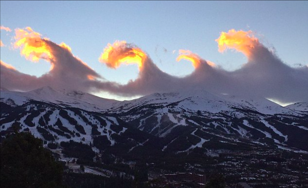
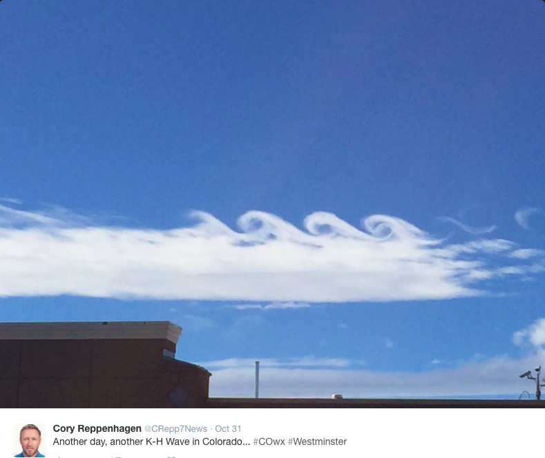
This beautiful pattern emerges in clouds when two different layers of air in the atmosphere are moving at different speeds. Where the two layers meet, another ‘sheer’ layer is created that becomes unstable due to the changes in speed. Pictured are Kelvin-Helmholtz clouds recently seen over Colorado
The Breckenridge Resort tweeted the video to highlight something known as Kelvin-Helmholtz waves, which can be found all over the solar system, including in Saturn’s atmosphere.
This beautiful pattern emerges in clouds when two different layers of air in the atmosphere are moving at different speeds.
Where the two layers meet, another ‘sheer’ layer is created that becomes unstable due to the changes in speed.
This creates a vortex and small wave-like patterns, which form into larger eddies.
‘The wind shear creates waves in the flow of air and when there is enough moisture present to make a cloud, the result is little rolling eddies seen along the top of the cloud,’ said Chris Spears, a meteorologist writing for CBS Denver.
‘These eddies are usually evenly spaced and easily identifiable and often don’t last too long.’
These clouds are known as Kelvin-Helmholtz instability clouds, named for Lord Kelvin and Hermann von Helmholtz, and they are formed due to wind shear in the atmosphere.
Wind shear is a change in either speed, direction, or both over a short distance.
The wind shear creates waves in the flow of air and when there is enough moisture present to make a cloud, the result is little rolling eddies seen along the top of the cloud…
These eddies are usually evenly spaced and easily identifiable and often don’t last too long.
Kelvin-Helmholtz instability clouds are most commonly seen in mountainous areas and they indicate extreme turbulence for aircraft.
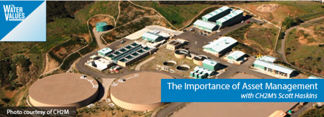
CH2M’s Scott Haskins, a Senior Vice President and Director of Strategic Consulting, joins The Water Values Podcast to discuss asset management programs. Scott’s breadth and depth of experience in the utility industry, including 30 years at Seattle Public Utilities, provides him a solid foundation on which to address the practical issues surrounding asset management. Scott guides us through asset management issues, including what asset management is, what are the different components of an asset management program and how to get started with an asset management plan. He also discusses risk issues and how utilities deploying asset management programs have saved millions of dollars and improved their service levels. Don’t miss this opportunity to learn from Scott.
In this session, you’ll learn about:
What asset management is
The components of an asset management program
How risk factors into an asset management program
The importance of customer engagement in targeting service levels
How environmental risk is quantified in asset management plans
The important questions to ask when considering an asset management plan
How asset management plans can scale
Where to start if your utility does not have an asset management plan in place
Examples of how asset management has helped utilities save millions of dollars in excess of the investment required
How benchmarking factors into an asset management plan
How frequently asset management plans should be reviewed
A group of Front Range water providers have told the Colorado Water Conservation Board to stop denigrating lawns and civic landscapes in the Colorado Water Plan, while at the same time, Western Slope organizations are telling cities to use less water to grow grass.
“Urban dwellers are entitled to a ‘reasonable recreational experience’ in the environment in which they reside,” the Front Range Water Council wrote in a Sept. 15 letter about the water plan.
“This includes adequate irrigation supplies for yards, public parks, recreation fields, open space, etc.,” the council said. “Many urban citizens, including those of limited economic means or physical limitations, or those who simply are not kayakers, fisherman, backpackers or skiers, engage in enjoyable outdoor recreational activities ‘in their own backyard.’”
The members of the Front Range Water Council are Aurora Water, Colorado Springs Utilities, Denver Water, Northern Water, the Pueblo Board of Water Works, the Southeastern Water Conservancy District and the Twin Lakes Reservoir and Canal Co.
The deadline for comments on the draft water plan was Sept. 17. The finished document is to be released Nov. 19 at a CWCB meeting in Denver.
Colorado Springs Utilities also sent its own letter to the CWCB, signed by M. Patrick Wells, the managing engineer for water resource planning for the utility.
“Many city dwellers value their city parks, ball fields, and backyards just as much as the scenic rivers or bucolic valleys, and they enjoy their urban environment far more often,” Wells said in his Sept. 17 letter.
But Ken Nuebecker, the associate director of the Colorado river program at American Rivers, walked across the Front Range’s lawn argument in his own comment letter to the CWCB on Sept. 14.
“While parks, ball fields and the urban forest have their place, we need to make sure that these engineered areas, which can easily be rebuilt, are not ‘protected’ at the expense of far more complex rivers systems which are not so easily ‘rebuilt,’” Neubecker said.
But lawns can lead people to nature, and to rivers, Wells told the CWCB.
“How can we expect current and future generations of citizens in urban areas to understand or appreciate the value of locally grown food in the lower Arkansas Valley or the importance of healthy rivers on the West Slope if they do not have healthy, sustainable outdoor spaces of their own to first make a connection with nature,” Wells wrote.
Wells also said “there remains too much focus on curbing outdoor water use” which “currently accounts for less than 4% of Colorado’s total water use.”
However, Andre Wille, the chair of the Pitkin County Healthy Rivers and Streams Board, suggested to the CWCB that healthy rivers may be a higher priority for many than lush lawns.
“Truly, no Coloradan believes our water supply should be satisfied by sacrificing our quality of life or the very natural environment that has brought so many of us here and supports at numerous levels our state’s vibrant and growing economy,” Wille said in an Sept. 15 letter to CWCB.
This sign, on the irrigated lawn outside the Aspen music tent, could well sum up how Front Range and Western Slope water organizations view each other.
The dissing of summer lawns
Denver Water CEO Jim Lochhead told the CWCB that the tone of the draft water plan was overly negative in regard to outdoor urban water uses.
“The assumption and tone of the plan that municipal use (particularly the roughly 3% of the state’s water use that supports urban landscaping) is somehow wasteful or less valuable than other uses of water needs to be removed and replaced with language that is respectful of all uses of water that are done in an efficient manner,” said Lochhead in a Sept. 17 letter.
Wells of Colorado Springs Utilities also said the tone of the first section of the water plan was “anti-growth and anti-city.”
“If the plan is to reflect the values of the citizens of Colorado, it must recognize and validate the values clearly espoused by the silent millions in the state who have voluntarily chosen the municipal lifestyle of single family residences with a reasonable amount of bluegrass lawn,” Wells wrote.
But the vision of a new wave of “silent millions” enjoying thirsty lawns on the Front Range creates apprehension on the West Slope.
The Roaring Fork Conservancy, which works to protect the heavily-diverted Roaring Fork River watershed, told that the CWCB that “outdoor water use is an area ripe for major conservation gains.”
“While Roaring Fork Conservancy doesn’t insist lawns are a thing of the past, local land use codes ought to mandate green infrastructure and water-efficient native landscaping in new development, and incentivize conversion for existing development,” said Rick Lofaro, the conservancy’s executive director, in a Sept. 17 letter to the CWCB.
And the Colorado River Basin Roundtable, which meets in Glenwood Springs under the auspices of the CWCB, took an even stronger stance on suburban lawns and civic landscapes.
“It has been said that municipal outdoor irrigation is but three percent of the state’s water use,’ the roundtable said in its Sept. 17 comments. “Outdoor water use, however, is roughly 50 percent of municipal demands in the irrigation season. In totality, it is the municipal gap – most often described as 500,000 acre-feet — that is driving the water plan. A high conservation level closes better than 90 percent of the gap.”
Denver Water’s Lochhead comes at it from the other side of the fence.
“Denver Water serves almost a quarter of the state’s population using less than two percent of all the water used in Colorado,” Lochhead told the CWCB. “Even if we eliminated all outdoor water use (approximately half of our total water demands), we would only make a one percent change in the State’s water usage.”
Meanwhile, the Colorado River District, which represents 15 counties on Colorado’s Western Slope, acknowledged the Front Range’s sensitivity about its lawns and civic landscaping.
“The River District does not wish to ‘demonize, lawn grass, the district told the CWCB in an unsigned memo on Sept. 17. “However, outdoor landscaping is by far the greatest, single consumptive use of municipal water supplies. Accordingly, the plan must include specific, measurable goals for turf-related conservation.”
Enjoying a recreational experience on grass.
Lawns aside, more water
And while Front Range water utilities tend not to intertwine their defense of lawns with a call for new water supplies, most of their letters do include direct calls for more water storage projects – new dams and reservoirs – and new transmountain diversions.
The Front Range Water Council told the CWCB that the water plan must “emphasize the need for ‘new’ storage as well as the expansion of existing facilities, and the state must advocate for policies that advance this end.”
Denver Water’’s Lochhead said that “conservation alone will not be enough to close the gap. Additional storage will be required to allow us to manage water efficiently and for multiple benefits.”
And Wells of Colorado Springs Utilities told the CWCB, somewhat deeper in its letter than the section about the virtue of lawns, that “the final plan should contain a definitive statement that a new transmountain diversion will be constructed, even if no formal concept has been proposed. Any plan that fails to include a section on new supply development … cannot be considered a comprehensive, strategic vision for meeting Colorado’s future water needs.”
Editor’s note: Aspen Journalism is collaborating with The Aspen Times and the Glenwood Springs Post Independent on the coverage of statewide water issues and the development of the Colorado Water Plan. The Post Indy ran a version of this story on Tuesday, Oct. 3, 2015.
From the Fort Collins Coloradoan (Jacy Marmaduke):
“This is kind of our mini-Yellowstone, so to speak,” said Mark Sears, standing before a crowd of 500 and gesturing toward the corral just minutes before the release about 2:45 p.m. Sunday.
Sears, Fort Collins’ natural areas program manager, was referring to the herd’s genetic origins in the Yellowstone National Park plains bison herd, which numbers more than 3,500 and is easily the largest in the world.
But bringing a bit of Yellowstone to Northern Colorado was easier said than done: Brucellosis, a contagious disease that causes cattle to abort, is ubiquitous among the Wyoming herd and has tempered the resurgence of genetically pure bison. Today, most of the 500,000 remaining bison in the U.S. and Canada have at least some domestic cow DNA because of interbreeding.
So Colorado State University researchers worked with the U.S. Department of Agriculture’s Animal and Plant Health Inspection Service to scrub Yellowstone semen and embryos of brucellosis, creating genetically pure, disease-free bison.
Colorado transmountain diversions via the State Engineer’s office FromAspen Public Radio (Marci Krivonen):
In October, a petition signed by 1500 Western Slope residents was delivered to Governor Hickenlooper, urging no new transmountain diversions be included in the Colorado Water Plan.
Then, at a meeting last Monday, Western Slope lawmakers reiterated the need to keep water in their region. Representative Bob Rankin was at the gathering in Glenwood Springs.
“We on the Western Slope contend that there is no more water to divert. We are already diverting a very large amount of water every year. The Denver/metro area and the farmers could always use more water. We on the Western Slope think there is no more water to be diverted.”
In an October 20th Denver Post article, Front Range conservancy districts that provide water to consumers said they want transmountain diversion plans included in the statewide plan. Jim Pokrandt contributed to the build-out of the plan. He chairs a group that focused on the Colorado River basin.
“Everybody got pretty excited about that Denver Post story but it’s not even clear where all those comments came from that indicated a transmountain diversion might happen,” he says.
He adds the Colorado Water Conservation Board assured him nothing radical – like a new diversion – would be added to the plan. The Board is in charge developing the plan. What was added is a goal for water storage, where reservoirs may expanded or be built.
“But, as some folks have said, you can build storage but you can’t store your way out of the problem. There are opportunities to store more water but storage is certainly not a silver bullet.”
The plan does mention some on-the-ground projects, but Representative Bob Rankin thinks more specificity is needed. Plus, the state aims to start raising $100 million annually starting in 2020, to implement it. Rankin wonders where the money will come from.
“We have to figure out where that money’s going to come from – is it user fees from water users? Is it a tax increase across the board? That’s a big question.”
Pokrandt says once the plan hits the governor’s desk later this year, it’s not a done-deal.
“There will be a chance to make more comment and edit it further down the road.”
The plan is aimed at addressing a projected 163 billion gallon shortfall in the state due to climate change and population growth.
Conceptual vision of potential transmountain diversions from the South Platte Roundtable Basin Implementation Plan