Northern Pike graphic via The Hook and Hackle Company.
Here’s the release from Colorado Parks and Wildlife:
A cash-based incentive offered by Colorado Parks and Wildlife and the Colorado Water Conservation Board encouraging anglers to catch northern pike at Green Mountain Reservoir resumes this year on May 25. Initiated in 2016, the reward program encourages anglers to participate directly in ongoing efforts to remove the illegally introduced predators from the reservoir.
CPW biologists say the presence of the predatory fish in Green Mountain is a significant concern. In addition to the potential impacts to fish in the reservoir, if they escape and take up residency downstream in Gold Medal sections of the Blue and Colorado rivers, sportfishing opportunities for trout could see negative consequences. If the predatory fish eventually reach federally listed critical habitat in the Colorado River, they would prey upon the state’s endangered native fishes – the Colorado pikeminnow, humpback chub, razorback sucker and bonytail.
“Northern pike are aggressive predators with big appetites and if their population continues to grow in Green Mountain Reservoir, that will likely have profound impacts to local fisheries in the future,” said CPW’s Jon Ewert, aquatic biologist from Hot Sulphur Springs. “This is beneficial in several ways. Anglers can catch a predatory fish and earn some money, it helps us protect fishing here, and helps with our native fish recovery efforts as well.
According to the Upper Colorado River Endangered Fish Recovery Program, the presence of predators like northern pike and smallmouth bass in native fish critical habitat significantly increases the difficulty of delisting the endangered fishes.
“We all have an interest in making sure our waters are managed appropriately and we encourage the angling public to stay involved,” said Ewert. “We had excellent response last year, and we expect anglers will be eager to take advantage of this opportunity again this year.”
To participate, anglers must bring their northern pike to the Heeney Marina along with their driver’s license and fishing license.
CPW will keep fish heads for analysis, returning the body of the fish to the anglers. Anglers not wishing to keep northern pike can donate their catch to the Marina for later distribution.
Anglers are encouraged to catch and keep as many smallmouth bass and northern pike as they desire, unless special regulations are in effect on specific waters.
For more information, contact CPW’s Hot Sulphur Springs office at 970-725-6200, or Heeney Marina at 970-724-9441
To report illicit stocking or any other illegal wildlife activity anonymously, anglers can call Operation Game Thief at 877-265-6648.
Click on a thumbnail graphic to view a gallery of snowpack data from the NRCS. Be cautious about the statewide map, percent of normal is not as meaningful after runoff starts.
Statewide Basin High/Low graph May 22, 2017 via the NRCS.
Upper Rio Grande River Basin High/Low graph May 22, 2017 via the NRCS.
South Platte River Basin High/Low graph May 22, 2017 via the NRCS.
Arkansas River Basin High/Low graph May 22, 2017 via the NRCS.
Gunnison River Basin High/Low graph May 22, 2017 via the NRCS.
Laramie and North Platte Basin High/Low graph May 22, 2017 via the NRCS.
San Miguel, Dolores, Animas, and San Juan Basin High/Low graph May 22, 2017 via the NRCS.
Yampa and White Basin High/Low graph May 22, 2017 via the NRCS.
Upper Colorado River Basin High/Low graph May 22, 2017 via the NRCS.
Statewide basin-filled snowpack map May 22, 2017 via the NRCS.
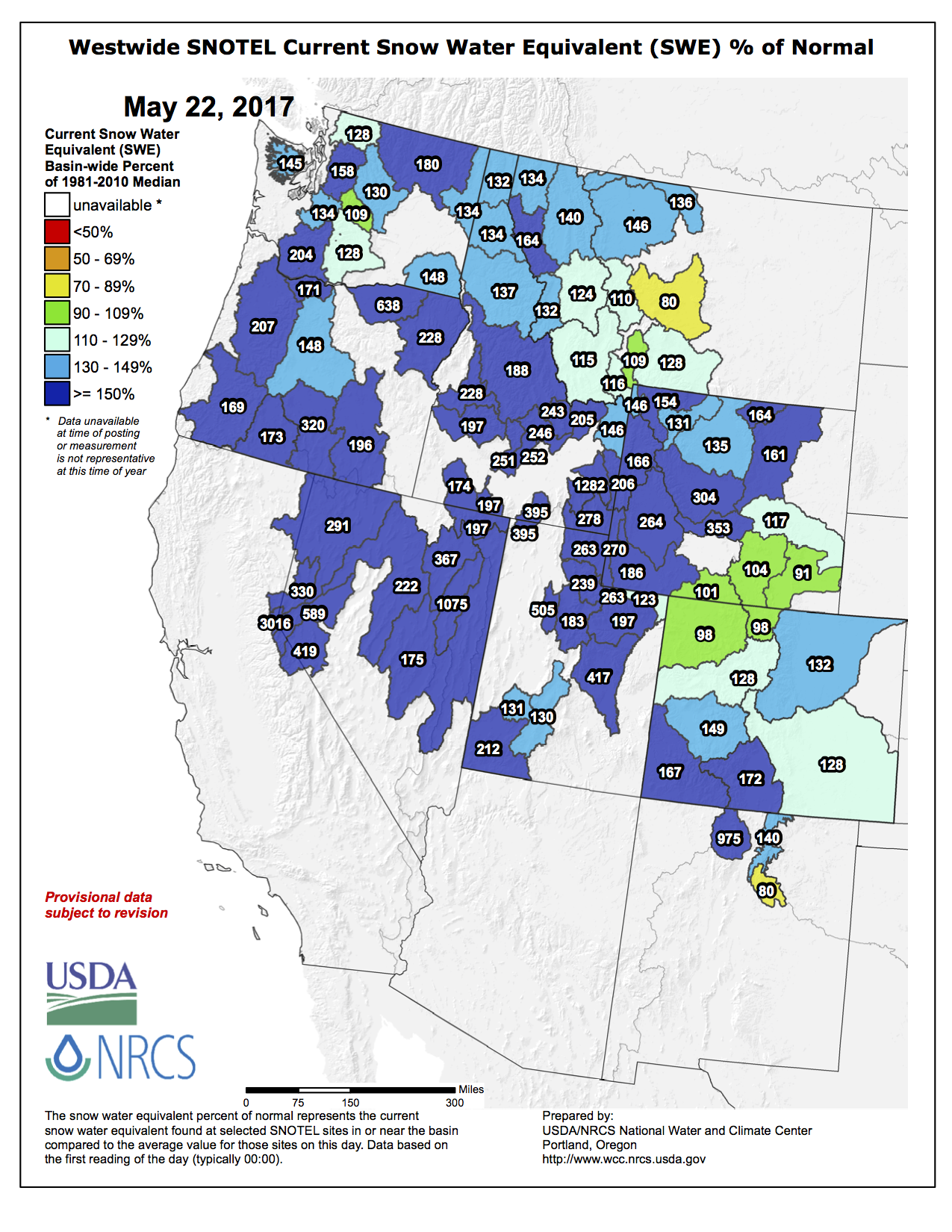
Here’s the Westwide SNOTEL basin-filled map from the NRCS.
Westwide SNOTEL basin-filled map May 22, 2017 via the NRCS.
Sweet corn near Olathe, CO. Photo credit Mark Skalny, The Nature Conservancy.
The Colorado River District has announced an additional funding opportunity (up to a total of $1.8 million) to support qualifying applicants for planning and implementation of irrigation efficiency improvement projects in the Lower Gunnison Project area. Applications from landowners that address identified resource concerns within the Bostwick Park, Paonia, Smith Fork, and Uncompahgre project areas will be accepted through July 21, 2017, for funding consideration.
This announcement of funding opportunity is an expansion of on-going, cooperatively-managed activities made possible by the Regional Conservation Partnership Program (RCPP) Environmental Quality Incentives Program (EQIP) for on-farm improvements, like conversion to pressure-piped sprinklers.
“We are excited to be able to continue to provide this funding that can be used to make our agricultural partners more productive and competitive while helping to meet important water resource management objectives,” explained Dave Kanzer, Project Manager and Deputy Chief Engineer of the River District.
Successful producer-applicants will receive financial assistance to plan, design and install advanced irrigation systems that address identified natural resource concerns. For example, these include projects that improve: 1) water availability (i.e., water use efficiency), 2) water quality (e.g. salinity and selenium loading), 3) soil health (e.g., cover cropping), and 4) fish and wildlife habitat (i.e., projects that benefit water quantity / quality). The Lower Gunnison Project uses an integrated application, contract process and a favorable cost-share ratio.
Interested applicants, landowners, and/or producers are encouraged to attend a Lower Gunnison Project Funding Interest Meeting in their area:
Hotchkiss: June 29 (6-6:15 pm light food/refreshments; Main program starts at 6:15 pm). Hotchkiss Memorial Hall, 276 W Main Street, Hotchkiss, CO 81419
Montrose: June 28 (6-6:15 pm light food/refreshments; Main program starts at 6:15 pm). Delta Montrose Electric Association (DMEA), 11925 6300 Rd, Montrose, CO 81402
An application and more information can be obtained by visiting the Shavano Conservation District (102 Par Place, Suite #4, Montrose, CO 81401 / Phone (970) 249-8407 Ext. 115) or Delta Conservation District (690 Industrial Blvd, Delta, CO 81416 / Phone (970) 399- 8194). Interested individuals can also contact the Colorado River District at (970) 945-8522 or go to the following website: http://gunnisonriverbasin.org/projects/lower-gunnison-project/
This funding opportunity complies with the rules and regulations of the Natural Resources Conservation Service Environmental Quality Incentive Program and is open to all eligible agricultural producers without discrimination or bias.
Colorado River headwaters tributary in Rocky Mountain National Park photo via Greg Hobbs.
Here’s the release from the Environmental Protection Agency:
EPA is launching a new website (www.epa.gov/wotus-rule) today to provide the public with information about EPA’s review of the definition of “Waters of the U.S.” (WOTUS) as set out in the 2015 “Clean Water Rule.” The site replaces the website developed for the 2015 rulemaking process.
“EPA is restoring states’ important role in the regulation of water by reviewing WOTUS,” said EPA Administrator Scott Pruitt. “The president has directed us to review this regulation to address the concerns from farmers and local communities that it creates unnecessary burdens and inhibits economic growth. This website aims to provide the public with information about our actions to meet the president’s directive.”
In the spirit of transparency, the site will provide the public with relevant information explaining the Agency’s actions, along with the Department of the Army and the Army Corps of Engineers (the agencies), to review the WOTUS rule, including how the agencies are working with our local, state and tribal partners, to examine our role in the regulation of water under the Clean Water Act. All the pages, information and documentation from the Clean Water Rule site will remain available in the EPA archived site, archive.epa.gov.
EPA is initiating consultation and coordination with stakeholders and the public as the agencies implement the February 28, 2017, Presidential Executive Order on “Restoring the Rule of Law, Federalism, and Economic Growth by Reviewing the ‘Waters of the United States’ Rule.”
The February Order states that it is in the national interest to ensure that the Nation’s navigable waters are kept free from pollution, while at the same time promoting economic growth, minimizing regulatory uncertainty, and showing due regard for the roles of Congress and the States under the Constitution. It also directs the agencies to review the existing Clean Water Rule (promulgated in 2015) for consistency with these priorities and to publish for notice and comment a proposed rule rescinding or revising the rule, as appropriate and consistent with the law. Further, the Order directs the agencies to consider interpreting the term “navigable waters,” as defined in the Clean Water Act at 33 U.S.C. 1362(7), in a manner consistent with the opinion of Justice Antonin Scalia in Rapanos v. United States, 547 U.S. 715 (2006). “Waters of the United States” are those waters that are protected under the Clean Water Act.
To meet these objectives, the agencies intend to follow an expeditious, two-step process that will provide certainty across the country: 1) an initial rulemaking to rescind the 2015 rule and recodify the regulatory definition that had been in place for decades and is currently being used in light of a nationwide stay of the 2015 rule, and thus maintains the status quo; and 2) a rulemaking to revise the definition of “waters of the United States” consistent with direction in the February 28, 2017 E.O.
The Town of Berthoud started filling Berthoud Reservoir on Wednesday after significant improvements have been made…
“This project was to deepen the reservoir, dredge it out, increase storage, and provide better water quality for the raw water treatment plant,” said Stephanie Brothers, public works director for the Town of Berthoud.
Prior to the Berthoud Reservoir Improvement Project, the water in the reservoir was safe for public consumption but carried an unpleasant taste and odor and had accumulated sediments, minerals, weeds and goose droppings, along with a problem of blue algae. Several municipalities along the Front Range struggle with blue algae resulting from shallow water usage, she said.
“It looks a little deeper, and there’s less vegetation. Hopefully with the vegetation gone, we got rid of the algae in there, and any future algae issues will be easier to control,” she added.
The sediment, which took up five to six feet of the bottom level of the reservoir, caused a loss of overall capacity. The sediment resulted from the town not dredging or cleaning out the reservoir since it took over ownership of it in 1890, according to Brothers.
The town hired Western States Reclamation, Inc., in Frederick, to dredge and improve the reservoir, spending $1.2 million on the entire project, using funds from the town’s raw water impact fee. Work began in October 2016, with the remaining work of filling the reservoir to be completed in early May.
The improvements expanded the reservoir’s capacity from 450-acre-feet to 574-acre-feet – prior to the improvements, the sediment had reduced what could be used to less than 400 acre feet.
The improvements included reconfiguring the structure of the reservoir, dividing it into two cells, with the east cell deeper than the west cell, and adding an internal dam. Once the reservoir is filled, the water in the east cell will be piped to the treatment plant and both cells will be used for storage, she said.
“The east cell allows us to have better water quality for the water plant because it’s deeper, and it makes it easier to manage,” said Mike Hart, town administrator.
Senate Bill 117, titled “Recognize Industrial Hemp Agricultural Product for Agricultural Water Right,” says Colorado water right holders have the right to use it on hemp if the person is registered by the state to grow hemp for commercial, or research purposes.
During an interview with The Journal, Hickenlooper said the hemp water bill will give farmers some reassurance, and he was cautiously optimistic that it could become a good cash crop for the state.
“Hemp is a very versatile product with a lot of uses, and it does not make sense why it’s illegal,” at the federal level, Hickenlooper said. “Having it grown and processed in the state could create a new niche market.”
Coram said he was motivated to introduce the bill after meeting with a farmer in the Arkansas Valley who said he could not use water from a Bureau of Reclamation facility to water his large hemp farm.
“I said this is wrong because hemp has a great future in Colorado,” he said. “The bill passed 99-1.”
Industrial hemp is used to make fuel, textiles, soaps and much more, but because it is a form of cannabis, it is banned by the federal government, even though it does not have the psychoactive properties of it’s genetic cousin, marijuana.
“The facts are that Colorado water rights are owned under Colorado law, and they can be used to grow hemp, which the state legalized,” said Catlin. “The federal government saying they cannot is overreach.”
The bill was introduced in the state Legislature by Sen. Don Coram, and sponsored by Rep. Marc Catlin. Both are Montrose Republicans.
“Our farmers grow hemp with that water, our ag researchers use that water for hemp, and this bill clarifies it is Colorado water being put to beneficial use,” Coram said.
Hemp farmers face some uncertainty if they irrigate with water from a federal water project because, as a genetic variant of marijuana, hemp is still considered illegal at the federal level under the Controlled Substance Act.
“It’s always been a concern for local hemp farmers, and a lot of them stopped growing because they did not want to risk losing water rights,” said Sharon King, a local hemp advocate. “This support from the state gives them some reassurance.”
Colorado has legalized hemp, and commercial permits have been issued through the Department of Agriculture since 2014.
The plant’s stem, leaves and flowers are used for making textiles, fuels, oils, soaps and medicine. Hemp is strictly regulated to ensure it does not exceed .3 percent THC, the psychoactive ingredient in the marijuana drug, which has THC levels of between 5 percent and 50 percent.
In Montezuma County, many hemp growers depend on water from McPhee Reservoir, a federal project managed by the Bureau of Reclamation and the Dolores Water Conservancy District.
Water Conservancy general manager Mike Preston said customers are allowed to use water to grow hemp, and the district supports Coram’s legislative effort to protect the hemp farmer.
“Those of us that supply water are confident our local farming community will make the most of any opportunity to test industrial hemp as a commercial crop,” Preston wrote to Coram in a March 17 letter. “Hemp being classified by the federal government as a drug is clearly a misclassification of an industrial crop.”
[…]
A 2014 Bureau of Reclamation policy manual stated the federal agency has an obligation to uphold federal law, which prohibits approving use of Reclamation water for activities not allowed under the Controlled Substances Act.
Arapahoe Basin Ski Area — the last resort still open in the state — reported more than 22 inches of snow over a four-day period to end the week, with the bulk falling very early Wednesday into Thursday and then most of the day Thursday into Friday. That total brings May’s snowfall in the area up to 24.5 inches, just the fifth time it has hit 24 inches or more since the start of the 20th century.
It’s the liquid-equivalent within the snow that matters most for water experts, however, and that remains difficult to determine until it eventually melts and can be properly measured. Even if historically this storm was a bit larger than those that typically descend upon the region in the spring, it is still not expected to represent more than 3 percent of the total moisture for the year.
“The runoff forecast doesn’t look at snow, it looks at total precipitation and the water content of the snow,” said Eric Kuhn, general manager of the Colorado River District. “Snowpack doesn’t tell you much, because cold weather can slow it and if it’s warmer it can accelerate it. It is a boost … but it could still end up average (levels) with this storm, it just depends on what happens in the next 10 days.”
[…]
Still, the approaching water year is predicted to remain at or perhaps slightly above average for the Colorado River as it snakes its way through Colorado and Utah (with allotments also for Wyoming and New Mexico) to Arizona’s Lake Powell before concluding in Nevada and California. The annual inflows into Powell function as the gauge of the West’s most recent runoff, and this year stands to be solid, but not considerable.
“It’s one of those years where we’ll take it,” said Kuhn. “It’ll bump Powell up 20-to-25 feet in elevation, which is good, but that’s still a long ways away from being full. It’s still down and there’s a bathtub ring.”
[…]
Another factor for what ends up in Powell, in addition to farther down in lower basin states, is what’s drawn off of it for drinking, recreation and crop irrigation en route. Transmountain diversions, which slurp up water off the Colorado River for the state’s dense population bases in cities like Denver, Aurora and Colorado Springs, are part of the reality, and a new one could soon be added to the equation.
The U.S. Army Corps of Engineers firmed up its approval of the Windy Gap Firming Project in northern Colorado to pull at least 30,000 more acre-feet from the state’s headwater region. The venture would construct the Chimney Hollow Reservoir, with a proposed capacity of 90,000 acre-feet, near the city of Loveland, and further expend the Colorado River before fulfilling out-of-state demands guaranteed under federal law.
Building concrete bulkheads in 130-year-old mine tunnels and stopes that connect Aspen and Smuggler mountains underneath town could form storage vaults capable of holding between 1,000 and 2,000 acre feet of water, according to a report from Deere and Ault Consultants of Longmont, presented in a work session to Aspen City Council last week.
The report listed pros and cons of using underground mines, which are an alternative approach to water storage the city is investigating as it looks for options other than 150-plus-foot tall dams creating reservoirs on upper Castle and Maroon creeks. Council also heard a presentation on Monday from Deere and Ault about a preliminary review of “in situ” storage — meaning in lined storage vaults underground where water mixes with gravel and is then covered. The golf course was identified as a site that could lend itself to such a reservoir, the consultants told council.
Deere and Ault’s review of underground mine storage, resulting in a 20-page report, found that the pros of using Aspen’s underground mines for storage — such as proximity to water rights and infrastructure, usefulness as drought hedging and good baseline water quality — to be outweighed by the potential cons.
“Maintaining dominion and control” of stored underground water is first among those concerns, according to consultants. Even with a complex system of bulkheads at virtually every level in the mines, “water could still potentially leak out through the natural faults, shear zones and fracture zones,” the report says.
Constructing the vaults would be hazardous, since water that collects naturally in the tunnels would have to be pumped out. When water is pumped out of old mines, “that’s when collapses occur,” Victor deWolfe, with Deere and Ault, told the council.
Raising the water table — hard to avoid with underground storage — also carries risk. It could create more surface landslides and exacerbates flooding issues. And while water occurring in the limestone layers has tested for good quality overall, raising it and lowering it above the water table could “exacerbate metal leeching and acidification.” That contaminated water could then leak into neighboring freshwater streams.
The city would also have to build an expensive pumping and pipeline system to connect the vaults to the water treatment plant near the hospital. New treatment techniques and infrastructure may also be needed to deal with alternative water storage method.
“We noted that there is no real precedence in Colorado for storing raw water in underground hard rock mines for municipal use,” the report says.
The consultants did envision a possible system, however, where water from the Salvation Ditch is used to fill the Molly Gibson Shaft. Or, bulkheads could be installed to raise water levels beneath Aspen Mountain, and the city could tap water flows coming out of the Durant Tunnel at the base of the mountain, where it owns a 3 cubic feet per second water right.
Aspen’s complex geology is well understood, the consultants note, and their study drew on maps showing the many rock layers and mine tunnels. The pond at the current Glory Hole Park, off Ute Avenue, formed in the mining era when alluvial soils were swallowed by a sinkhole, taking a locomotive and two boxcars with it.
Council members thanked the consultants for the report — the study, which included site visits, cost the city $15,000 — but showed little appetitive for pursuing the issue further. Councilman Bert Myrin said it’s crucial for the city to determine how much water it needs to store before it can make sense of options.
Deere and Ault will continue looking into the “in-situ” reservoir concept, which also could yield 1,000 or more acre feet of storage.
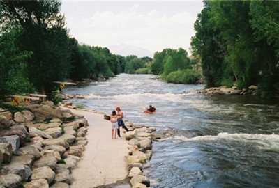
FIBArk organizers are encouraging volunteers, athletes and parade entrants to register for the 69th annual whitewater festival at FIBArk.com.
FIBArk will take place June 15-18 in downtown Salida.
According to a press release, several hundred volunteers are needed to assist in many capacities, helping with everything from beer tent duties to merchandise sales and athlete registration. Volunteers with river-related experience are especially needed.
Shifts are usually a couple of hours and provide a way for businesses, clubs, organizations or individuals to see friends and neighbors and greet out-of-town guests, FIBArk organizers said in the release.
All volunteers will receive a FIBArk volunteer T-shirt.
Athletes and parade entries also may register at FIBArk.com. Each year almost 800 athletes participate in FIBArk events, and organizers said registering in advance online will cut down on congestion and wait times at the boathouse.
Each year since 1949 the festival has included a parade. Sponsored by Moltz Construction, this year’s parade will begin at 10 a.m. June 17 with its traditional route along F Street. All Hooligan Race participants receive free entry into the parade.
The report was the same from Kevin Houck, chief of watershed and flood protection for the Colorado Water Conservation Board.
“I think the cooler weather is going to minimize” runoff issues. “This cool air just shuts down the runoff, and while it can speed back up if we had a really big warm-up come this way, I’m not seeing any forecasts calling for that. I think it’s going to be a pretty controlled runoff. Elevated for a few days, but nothing close to flood levels.”
[…]
Snow totals across western Boulder County from the spring storm were impressive. According to the National Weather Service, 42 inches fell southeast of Allenspark, through Friday morning. A total of 41.7 inches came down northeast of Ward, also as of Friday morning. And by 7 a.m. Friday, 30 inches had accumulated northeast of Nederland.
The totals down low were less significant, with Boulder meteorologist Matt Kelsch reporting 6.1 inches of snow in the city through 7 a.m. Friday, and a total of 3.4 inches of liquid precipitation, in both rain and snow, since the storm’s onset.
“I have not seen all of the updated snowpack figures yet,” Kelsch said in an email. “We were running a little below average for this time of year as of May 1st (Coal Creek, Boulder Creek and St. Vrain Creek were 85-90 percent of average). My guess is that we are at least a little above average now.
“That does increase the risk of high flows and maybe some out-of-bank flows over the next few weeks. The extent depends on temperature and precipitation over the next few weeks. A very rapid warm-up could cause a fast melting and more risk of flooding.”
Dave Gochis, a hydrometeorologist at the National Center for Atmospheric Research in Boulder, also issued a note of caution.
“There certainly is a heightened risk from the recent precipitation,” Gochis said in an email. “The actual occurrence of flooding will depend on how much more precipitation we get, as well as how quickly we warm up after this event moves out.
“Forecasts from the National Water Model are showing appreciable rises in streamflow across the Front Range moving into next week mostly due to melt runoff. Streams will come up, but I think more serious flooding will depend strongly on whether or not we get some heavy rain showers on top of this current condition of wet soils and wet and melting snow.”
Fryingpan-Arkansas Project via the Southeastern Colorado Water Conservancy District
From the Southeastern Colorado Water Conservancy District via The Pueblo Chieftain:
A hefty snowpack and relatively full municipal storage means farms will get a larger than usual share of Fryingpan-Arkansas Project water this year.
About 80 percent, or 44,000 of the 55,000 acre-feet allocated by the Southeastern Colorado Water Conservancy District board Thursday, will go to irrigation companies throughout the Arkansas River basin. In addition, agricultural interests were allocated 20,000 acre-feet in return flows. A total of 28 ditches and three well groups will benefit.
That water comes on top of about 12,000 acre-feet leased earlier this year by Pueblo Water to farms, ditches or well associations…
“The extra water which the municipalities have no place to store is always welcome in Crowley County and the Arkansas Valley,” said Carl McClure, a Crowley County farmer who heads the allocation committee of the district.
The Southeastern allocation is about 25 percent above average, thanks to a snowpack that remains heavy and is still growing. The Fry-Ark water is imported from the Upper Colorado River basin through the 5.4-mile long Boustead Tunnel into Turquoise Lake.
More than half of the water is reserved for cities, but if they have no place to store it, it is allocated to agriculture. Fry-Ark water sells for $7 per acre-foot, plus surcharges that pay for programs that benefit water users. By comparison, Pueblo Water leases averaged $55 per acre-foot this year.
The district expects to bring more than 68,000 acre-feet into the Arkansas River basin this year, but prior commitments such as the Pueblo fish hatchery, evaporation and transit loss adjustments are made before the amount of water sold can be determined.
The Southeastern district guarantees 80 percent of the water, holding back some in case the runoff fails to meet projections. The Boustead Tunnel can only take a certain amount of water at one time and only when sufficient flows, as determined by court decrees, are available on the Western Slope. The remaining 20 percent is delivered when the district determines flows will be sufficient.
That should not be a problem this year, as the Bureau of Reclamation projected imports to be about 77,000 acre-feet, well above the amount Southeastern factored in.
For municipal allocations, the Fountain Valley Authority was able to take about 7,000 acre-feet, or half of its entitlement. Pueblo Water and Pueblo West are not seeking any water. Cities east of Pueblo claimed 3,132 acre-feet, while cities west of Pueblo were allocated 1,164. Most chose not to request their full allocation.
Allocating Fry-Ark water is the primary function of the Southeastern District, which was formed in 1958 to provide supplemental water to the Arkansas River basin.
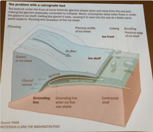
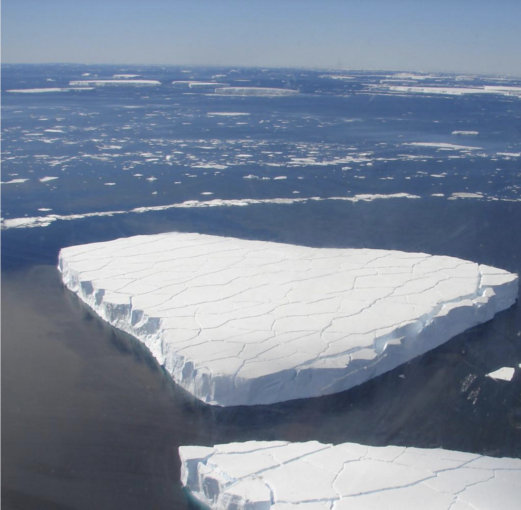
Geomorphology of the Antarctic ice shelfs. Slide via Brad Udall, South Platte Forum, October 27, 2016.
Here’s Part 1 of the “Antarctic Dispatches” series from The New York Times. Click through and read the whole article. Here’s an excerpt:
Because the collapse of vulnerable parts of the ice sheet could raise the sea level dramatically, the continued existence of the world’s great coastal cities — Miami, New York, Shanghai and many more — is tied to Antarctica’s fate.
Four New York Times journalists joined a Columbia University team in Antarctica late last year to fly across the world’s largest chunk of floating ice in an American military cargo plane loaded with the latest scientific gear.
Inside the cargo hold, an engineer with a shock of white hair directed younger scientists as they threw switches. Gravity meters jumped to life. Radar pulses and laser beams fired toward the ice below.
On computer screens inside the plane, in ghostly traces of data, the broad white surface of the Ross Ice Shelf began to yield the secrets hiding beneath.
“We are 9,000 miles from New York,” said the white-haired engineer, Nicholas Frearson of Columbia. “But we are connected by the ocean.”
Water and Climate Change are both areas that bring Coloradans together. Here’s a report from Scott Condon writing for The Aspen Times. Click through and read the whole thing. Here’s an excerpt:
Boulder County Commissioner Elise Jones, a former executive director of the Colorado Environmental Coalition, said the county’s research indicated that local action on climate could only achieve small improvements. The critical components are federal fuel-efficiency standards for vehicles and state mandates for renewable energy use by public utility companies, she said.
But Brad Udall, a researcher at the Colorado Water Institute at Colorado State University, said local actions are equally critical.
“This is the single most important issue facing humanity,” Udall said. Researchers are continually learning more about the consequences of the planet warming. “The science is compelling.”
[…]
Udall said farmers and others who work closely with the land understand that the climate is changing.
“As this affects people, they can do nothing but get aboard,” he said.
On the local level, taking action to reduce greenhouse emissions from vehicles and in buildings can be a tremendous help, he said.
More than 40 elected officials from Colorado municipalities and counties attended the conference organized by Aspen Mayor Steve Skadron. Ironically, several people who signed up were unable to attend because of travel woes created by a mid-May blizzard.
Skadron said he convened the meeting because he was inspired after attending the Paris Climate Change Conference in 2015. He had been invited along with mayors of major cities because Aspen gained attention for getting its municipal utility converted to 100 percent renewable energy. Skadron initially felt he shouldn’t attend.
“I didn’t think it was appropriate for a small-town mayor,” he said.
He reconsidered after talking to Aspen Skiing Co. Vice President of Sustainability Auden Schendler, whose philosophy is Aspen should use the limelight as an internationally famous resort as a lever on important issues.
Skadron decided to go, but not just sit in the audience and clap. Aspen Climate Action manager Ashley Perl used her connections to get Skadron on three committees convened at the Paris talks. His message: curbing greenhouse-gas emissions is urgent, collaboration is necessary and local officials must drive action and force cooperation at the state and national levels.
Since Paris, Skadron has spoken on climate issues in Taiwan, South Korea and Dubai, all on their dime, not at the expense of Aspen taxpayers.
“It really catapulted Aspen’s climate plan to a new level,” Perl said.
Click here to read the assessment. Here’s an excerpt:
Globe had second warmest April and year to date on record
The globally averaged temperature over land and ocean surfaces for April 2017 was the second highest for the month of April in the NOAA global temperature dataset record, which dates back to 1880. The year-to-date global temperature was also second warmest on record.
This monthly summary is part of the suite of climate services NOAA provides to government, business, academia, and the public to support informed decision-making.
April Temperature
The April temperature across global land and ocean surfaces was 1.62°F above the 20th century average of 56.7°F. This was the second highest for April in the 138-year period of record, behind 2016 by 0.31°F.
The April globally averaged land surface temperature was 2.47°F above the 20th century average of 46.5°F. This value tied with 2000 and 2010 as the fourth highest April land global temperature in the 1880–2017 record.
The April globally averaged sea surface temperature was 1.31°F above the 20th century monthly average of 60.9°F. This was the second highest global ocean temperature for April in the record, behind the record year 2016 by 0.09°F.
April Snow Cover and Sea Ice
According to data from NOAA analyzed by the Rutgers Global Snow Lab (link is external), the Northern Hemisphere snow cover extent during April was 3.1 percent above the 1981–2010 average. This was the largest April snow cover extent since 2013 and the 16th largest value in the 51-year period of record. The North American and Eurasian snow cover extent were each the 21st largest on record.
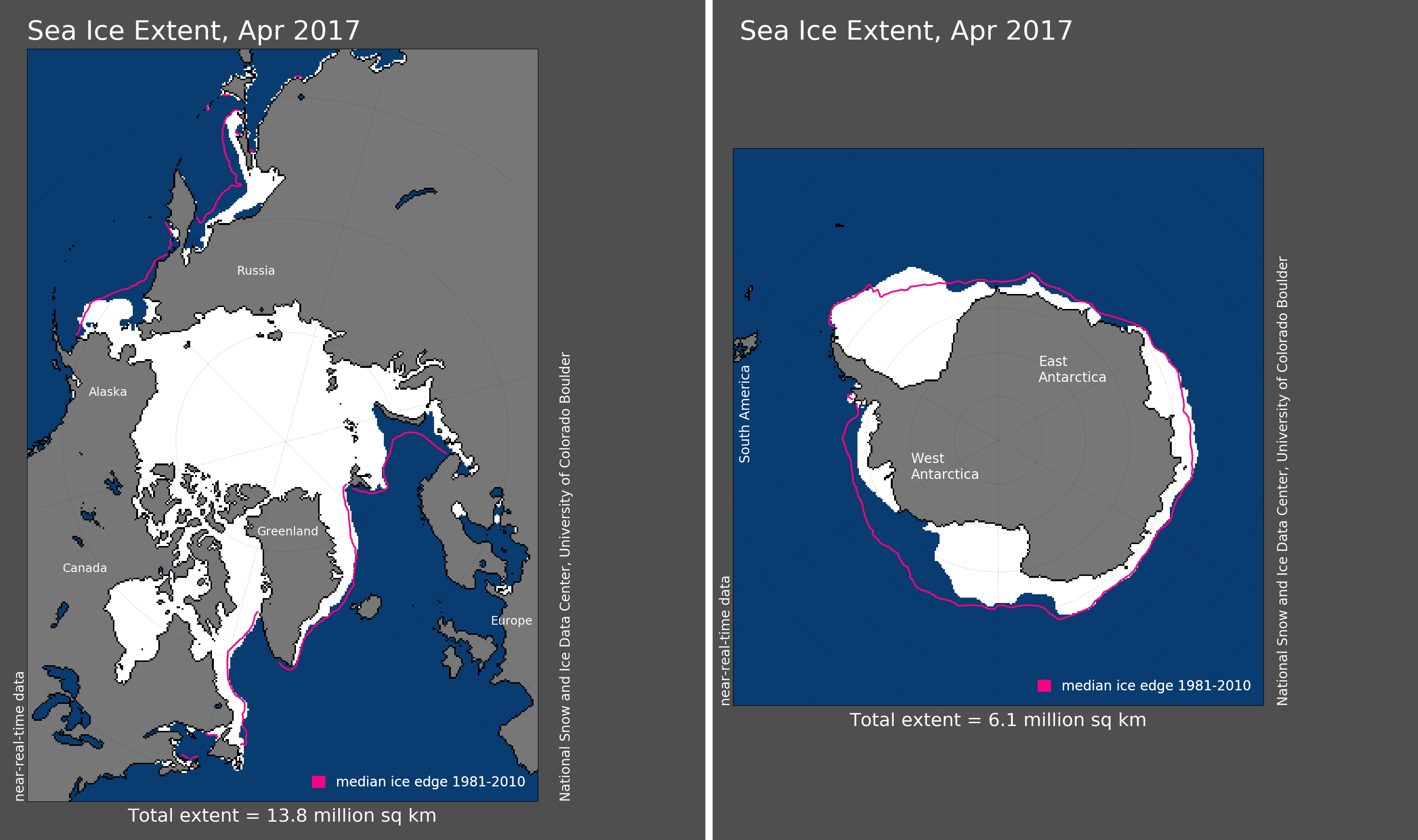
The average Arctic sea ice extent for April was 394,000 square miles (6.9 percent) below the 1981–2010 average. This tied with April 2016 as the smallest April sea ice extent since records began in 1979, according to an analysis by the National Snow and Ice Data Center (link is external) based on data from NOAA and NASA.
The Antarctic sea ice extent for April was 520,000 square miles (18.2 percent) below the 1981–2010 average. This was the second smallest April Antarctic sea ice extent since records began in 1979 and 50,000 square miles larger than the record smallest extent set in 1980. This ended a five consecutive-month streak of record low sea ice extent in the Antarctic that started in November 2016.
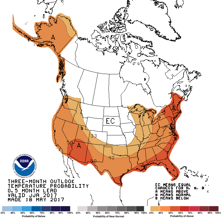
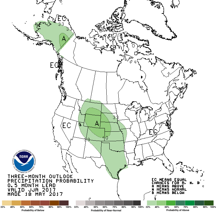
Three month temperature outlook for June, July, and August 2017 via the Climate Prediction Center.Three month precipitation outlook for June, July, and August 2017 via the Climate Prediction Center.Three month temperature outlook for June, July, and August 2017 via the Climate Prediction Center.
Here’s the drought discussion:
Drought coverage across the country has progressively declined over the past several months, as assessed by the Drought Monitor. At the end of November 2016, drought encompassed more than one-quarter of the nation. That number dropped below 12 percent at the end of March 2017, and to 4.2 percent in early May, the least coverage since Drought Monitor statistics were first calculated at the beginning of 2000. In the last four weeks, drought was alleviated in substantial parts of the Northeast, Middle Atlantic States, and south-central Plains. However, latent long-term moisture shortages remain across the Northeast, and drought could re-develop quickly should any substantial period of abnormal heat and dryness occur. Currently, drought covers much of Florida, Georgia, and eastern Alabama, with extreme drought affecting the central Florida Peninsula and portions of both southern and northern Georgia. Scattered areas of drought exist elsewhere across the southern tier of states from South Carolina to central Texas. Farther west, drought covers isolated spots in central Colorado and northeastern Wyoming, portions of southwestern California, a swath from southernmost California eastward into southwestern New Mexico, and western parts of the Big Island of Hawaii. In the contiguous states, drought is expected to persist or intensify in southern California and southwestern Arizona, where above-normal temperatures and seasonably dry conditions are expected. Drought persistence is also favored from west-central Georgia into central and northeastern South Carolina due to seasonal topsoil decline, and less rainfall expected through the rest of the month than in neighboring areas. At least some improvement is expected in other drought areas. In Hawaii, drought on western parts of the Big Island should persist, except along the lower Kona Slopes in the northwesternmost reaches of the Big Island, where summer is a markedly wet time of year.
Colorado National Monument from the Colorado River Trail near Fruita September 2014
Click here to read the newsletter. Here’s an excerpt:
ALTERNATIVE AG TRANS REPORT
The Colorado Water Institute has released a special report on how to advance in Colorado with Alternative Transfer Methods (ATMs), which move water from agriculture to other uses without permanently drying up farmland. The recommendations include establishing separate working groups for ATM’s to provide water for urban use and ATM’s to facilitate Colorado River Compact compliance.
The big winter in California—and, before that, four years of not much snow? The big and repeated snows in Boston several years ago?
They, along with many of other extreme weather events, might be joined at the hips with the melting ice in the Arctic Ocean. That’s the emerging evidence described on a webinar by Jennifer Francis of Rutgers University.
“There’s a ton of research that has been going on lately in regard to this issue of how the rapid melting and warming may or may not be connected to the extreme weather that has been going on around the globe,” she said in the session sponsored by the Metcalf Institute for Marine & Environmental Reporting.
The line of reasoning is that there has been an uptick in the number of extreme events. Some, such as Roger Pielke Jr. of the University of Colorado-Boulder, have disputed at least part of this evidence. They argue that more people are living in harm’s way, such as in beach-front locations vulnerable to hurricanes or along rivers, thus bloating the damages when storms do occur.
Jennifer Francis. Photo via The Mountain Town News.
Francis, in her 30-minute talk, didn’t acknowledge that argument, but instead pointed to something called the “Arctic amplification” beginning in about the mid-1990s. She acknowledged some difficulty with defining extreme weather events. “It’s a very hard to get robust statistics on these changes. The atmosphere is a very noisy place,” she said.
But the extreme events like the drought in the Sierra and the snow in Boston do have something in common: They’re caused by “stuck” weather patterns.
“This I where the Arctic may be playing a role,” she said.
Temperature increases have been well documented. “Globally, we’re on the edge of a 1.5 degree Centigrade increase in year-to-year anomalies compared to the 1881-1981 baseline. “We are in a very disturbing situation here. We are getting warmer and warmer, and we are already bumping up against the 1.5 degrees that the Paris agreement set as a limit.”
This warming has been particularly evident in the Arctic. It has been warming two to three times more rapidly than the rest of the globe. At times, and not just summer, it has had temperatures as warm as those of New York City. In summer, the ice has ebbed at a pace far more rapid than the losses predicted by climate models.
The summer ebb of sea ice is also wildly out of proportion to the ebbs and flows during the last 1,450 years as documented by the study of sediments on the bottom of the Arctic Ocean.
“There are lots of ups and downs, little wiggles, but it’s been pretty steady up until modern times,” she said.
In late March, scientists with the National Snow & Ice Data Center reported that air temperatures lat autumn and winter had been 2.5 degrees Celsius (4.5 degrees Fahrenheit) above average over the Arctic Ocean. The overall warmth was punctuated by a series of extreme winter heat waves over the Arctic Ocean, continuing the pattern also seen in the winter of 2015. This, they say, contributed to a record minimum winter ice advance.
“I have been looking at Arctic weather patterns for 35 years and have never seen anything close to what we’ve experienced these past two winters,” said Mark Serreze, the NSIDC director, said in a March release.
“We are clearly in uncharted territory,” said Francis in the webinar this week.
As the ice melts, white is replaced by the dark blue of the open ocean. Instead of solar radiation being reflected, it’s being absorbed. This, in turn, helps heat the atmosphere even more.
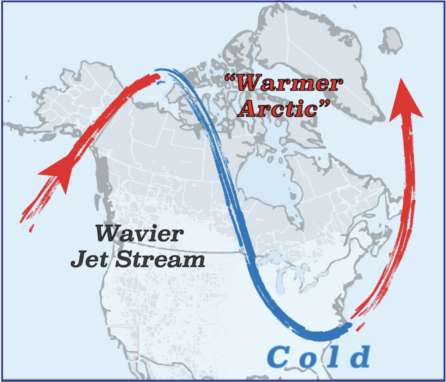
But there’s also this confusing fact: as the Arctic warms, there can be unusual cold in the eastern United States and parts of Asia. The mid-latitudes overall have been warming very slowly as compared to the Arctic.
North America: Warming Arctic Temperatures Can Reinforce Wavy Jet Stream. Graphic via The Mountain Town News.
This is explained by the Arctic amplification. It disrupts the fast-moving river of high-altitude air called the jet stream. The jet stream creates our weather as it moves across North America. Instead of a straight line, thought, it tends toward greater meandering or waviness.
Now scientists are starting to use a new word, sinuosity, which is a metric of how wavy the jet stream becomes. The greater the sinuosity, the greater the waviness. This increased waviness, in turn, results in persistence of weather patterns, such as the snow and cold of Boston and the dry ground of December in the Sierra Nevada.
Francis cautioned that not all extreme weather can be directly linked to the warming of the Arctic and the shifting of the jet stream. But there is a link reflected in the number of extreme weather events.
“Weather patterns really are changing, but they are affected by so many things,” she said: storm tracks, the jet stream, planetary waves. “It’s a really very complicated story, but we really are starting to get a handle on some of these mechanisms.”
I’d like to have asked her whether snow in Denver less than two weeks before Memorial Day had anything to do with the disappearing Arctic sea ice, but the webinar ended.
City crews are officially starting work to repair stormwater drainage after Colorado Springs voters passed Ballot Issue 2 back in April.
It comes with a price tag of $12 million dollars in excess revenue.
“This multi phase project will address flooding in the hardest hit area in the Little Shooks Run neighborhood by making several improvements to the drainage system through the end of 2017,” Mayor John Suthers, with the city of Colorado Springs explained.
The project will use $6 million this year and another $6 next year.
“It’s just an example of how we can take needed dollars and fix issues that have been around for a long time.” said Water Resources Engineering Division Manager Rich Mulledy.
The projects directly impact other parts of Southern Colorado. Pueblo county and city leaders have dealt with their share of storm water issues also, stemming from Fountain Creek.
“A lot of erosion and occasionally a sewer spill,” said Steve Nawrocki, Pueblo City Council President has said.
FromThe La Junta Tribune-Democrat (Bette McFarren) via the The Ag Journal:
The Lower Arkansas Valley Water Conservancy was honored to host Gov. John Hickenlooper’s signing of HB17-1248 on Wednesday after the regular meeting of the board of directors. The bill concerns the funding of Colorado water conservation board projects, and in connect with this undertaking, making appropriations. Hickenlooper said there is $25 million of support attached to the bill, making projects of LAVWCD and other water projects possible. He also alluded to HB17-1233, signed in Denver the same day, which allows farmers and ranchers practicing conservancy not to lose their water rights.
Hickenlooper was very complimentary to LAVWCD Manager Jay Winner, whose novel ideas have helped to keep the water on the land in southern Colorado. He said he wished he had a dozen Jay Winners to preserve the water for he state. Winners and John Stulp will be very happy, he said, putting their ideas into practice, made easier with these acts. One look at how Crowley County is struggling, he said, is sufficient to know southeastern Colorado cannot survive with dryland farming.
Also present at the signing was State Senator Larry Crowder, whom Hickenlooper commended for always voting for what he considers right, despite party lines. Hickenlooper also expressed his admiration for Lt. Gov. Donna Lynne, who has done a lot for the organization of the administration, drawing on her experience in the private domain in a much higher-paying position.
He is proud of the Colorado Water Plan and looks forward to its implementation. Thirty thousand individuals contributed to the formation of the plan. Although it does not yet have full funding, water rights of individuals are protected and the plan will keep the water on the land.
Senator Crowder said he represents 15 counties with average income at or below poverty level and he intends to do everything he can to promote economic opportunities for the area. He will work with people of differing viewpoints to make this possible. Hospitals are stable financially in the Denver area, he said, but not in rural Colorado, and everything possible must be done to maintain them.
Salida will receive $666,069.72 in loan forgiveness for its $1,505,000 loan from the [Colorado Water Resources and Power Development Authority] for the city’s ultraviolet disinfection compliance project, City Administrator Guy Patterson announced in the Tuesday city council meeting.
“The [CWRPDA] had a unique situation last year where a sizable amount of design and engineering grant money was not utilized,” Patterson wrote in a report to the council.
“The fact that Salida was the first community to execute the loan in 2017 and the disadvantaged community status made us eligible for disbursement of the funds, along with several other communities.”
“This is very fortunate for the community to be recognized like this and get the grants,” Mayor Jim LiVecchi said. “We were trying to do what we could to get this project paid for without having to raise water rates or spend taxpayer money.”
LiVecchi said the city also received $755,000 in an Energy/Mineral Impact Assistance Fund grant from the Department of Local Affairs.
Emails from The Mountain Mail to Patterson, Public Works Director David Lady and Finance Director Jana Loomey about the project went unanswered.
The Mountain Mail asked city officials the following questions:
•The loan from the [CWRPDA] was for $1,505,000, the loan forgiveness was $666,069.72, leaving the remaining loan amount at $838,903.28, which knocks off about 44 percent of the loan. How much of this loan has been paid off thus far? Also, there was another loan listed for $120,000. Does that mean the total cost of the UV project was $1,625,000, or was it more?
•It was stated that because the loan was passed under an emergency measure to keep construction costs within a single fiscal year, the water and wastewater funds will lose their enterprise fund status for 2018. Does this still apply with the loan forgiveness taken into account?
•Patterson said in his report to council that Salida’s “disadvantaged community status” made the city eligible for the disbursement of the funds “along with several other communities.” What is “disadvantaged community status” and how did Salida qualify? Also, do we know which other communities received funds?
•What is the status of the UV project? Is it finished? If not, what is the basic timeline for completion?
Deputy City Clerk Christian Samora said Wednesday the city will send out a press release in the next day or two.
Map from Northern Water via the Fort Collins Coloradan.
From the Loveland Reporter-Herald (Pamela Johnson):
The U.S. Army Corps of Engineers’ final decision allowing Northern Water to build Chimney Hollow Reservoir southwest of Loveland, issued 14 years after the federal permitting process began means, that construction could begin in late 2018 and water begin filling in 2022.
That same year, an open space around the reservoir with trails, backcountry camping and boating should open under the management of Larimer County’s Department of Natural Resources.
The permits that allow Northern Water to finish design and begin building the $400 million reservoir on behalf of 13 municipal water providers, including Loveland, require several different actions to mitigate environmental damage or concerns.
[Eric] Wilkinson, general manager of Northern Water, summarized some of the mitigations associated with Chimney Hollow Reservoir, which will store water pulled from the Colorado River through the Windy Gap project.
• Maintaining certain water temperatures on the Colorado River to make sure the habitat for fish stays healthy.
• Paying for about $4 million worth of stream channel improvements on the Colorado River for 14 miles ending near the confluence of the Williams Fork River, to make significant enhancements to aquatic habitat.
• Flush flows every six years to move sediment and improve habitat.
• Construct a channel that will carry the water around Windy Gap Reservoir, allowing fish to migrate through that area and improving spawning conditions in the Colorado River downstream of Windy Gap.
• Replace wetlands that will be destroyed by the actual construction of the reservoir with similar acres in another location.
• Conduct stream restoration along the Little Thompson River in two locations to help restore that channel to its pre-2013 flood conditions and maintain those enhancements over the long term.
Chimney Hollow will hold about 90,000 acre-feet of water, enough for more than 90,000 households, that will be pulled from the Colorado River in wet years and stored for use in dry years.
The Windy Gap Firming project and its accompanying Chimney Hollow Reservoir has been approved, paving the way for more reliable water across the Front Range while also further draining the Colorado River.
The Windy Gap Project has its roots in the 1980s, and was intended to provide the Front Range with more than 40,000 acre-feet of water from the Colorado River. But without enough storage capacity, municipalities haven’t realized that yield every year.
“We are pleased to make it to this milestone with our partners at Northern Water and all of the other communities involved,” Greeley City Manager Roy Otto said in text message Thursday.
The firming project, centered on the construction of Chimney Hollow Reservoir near Carter Lake, is expected to address that problem at a cost of about $400 million.
The Army Corps of Engineers gave final approval Wednesday, and construction should start in late 2018 or early 2019.
It’s a project nearly 15 years in the making.
“We’re ecstatic,” Northern Water spokesman Brian Werner said. “You get one of these (types of projects) done in your whole lifetime.”
Water for the reservoir would be pumped from the Windy Gap Reservoir on the Colorado River near the town of Granby, west of the Continental Divide, through an existing tunnel under the Rocky Mountains to the east side of the divide.
Greeley is one of 12 beneficiaries of the project, which also will create more reliable water supply for Fort Lupton, Longmont and Loveland.
Chimney Hollow Reservoir will hold 90,000 acre-feet of water, and Greeley will get about 9,200 acre-feet of water per year from the project.
An acre-foot of water is 326,000 gallons, or equivalent to a foot of water covering a football field. Greeley residents, according to the city’s new water budget, will use about 20,000 gallons per year.
Sen. Cory Gadner, R-Colo., also applauded the decision, calling the project a major component of Colorado’s longterm water needs.
“Getting to this point has been years in the making, and it is hard to state just how important it is that Northern Water can finally move forward with construction,” Gardner said in a news release.
The project’s approval was met with resistance from some water conservation advocates, though, including Gary Wockner with Save the Colorado and Save the Poudre.
“The Colorado River is on life support right now,” Wockner told the Associated Press. “If the patient is bleeding out, you don’t cut open a new artery to try and heal it. Instead, you should work to protect and restore the river, not further drain it.”
Save the Colorado is opposed to the Windy Gap project, and Wockner told The Tribune it’s likely his group will file a lawsuit in federal court to stop the project.
“Our policy is no new dams and diversions out of the Colorado River system,” Wockner said. “This is a dam and diversion, so we’re going to do everything we can to stop it.”
Wockner, who said the Colorado River is being overused, instead calls for more water conservation, including moving away from green lawns, recycling water and managing growth better.
Werner points to the endorsement of Democratic Gov. John Hickenlooper, officials in Grand County on the Western Slope and Trout Unlimited, a trout and salmon conservation organization as proof the Windy Gap Firming project’s strong support.
Before the Windy Gap Firming project, Colorado had never endorsed a water project that has come before the federal government.
Without the project, Werner said municipalities would have to do what they’ve always done in particularly wet years: dump the excess water down the Colorado River rather than saving it for drier times.
“There is still a lot of work to do,” Otto said. “This project, along with the expansion of Milton Seaman Reservoir, are critically important to Greeley’s longterm water needs.”
Where now with Alternative Transfer Methods in CO?
This special report, released by the Colorado Water Institute, summarizes the discussions, conclusions, and recommendations from three meetings held in the fall of 2016 to address Colorado’s Water Plan’s measurable objective to provide at least 50,000 acre-feet of agricultural water to municipal water providers through voluntary, compensated Alternative Transfer Methods (ATMs) by 2030. These meetings convened water stakeholders from across the state, representing the interests of diverse sectors of the water community – agricultural, urban, and environmental. The report is intended to provide a foundation on which further progress toward meeting Colorado’s Water Plan’s ATM goal can be built. The report was co-authored by Anne Castle, MaryLou Smith, John Stulp, Brad Udall, and Reagan Waskom and is available on Colorado’s Water Plan website under Implementation.
Release at Cherry Creek dam during a low flush year. (Photo by USACE)
Here’s the release from the US Army Corps of Engineers Omaha office (Katie Seefus):
The annual sediment flushing exercise will be conducted at Cherry Creek Reservoir on Wednesday, May 24, 2017.
Katie Seefus, water manager in the Corps’ Omaha District office, says the exercise involves high releases from each of the five main outlet gates at Cherry Creek Dam, located south of Interstate 225 in Aurora, Colo. “When the gates are opened, the high velocity of the water leaving the reservoir scours the area immediately upstream of the gates and transports sediment with the flow,” said Seefus. This sediment flush is required to allow proper operation of the outlet gates.
Cherry Creek Dam will begin releasing 50 cubic feet per second (cfs) at 2:30 p.m. on Tuesday, May 23. The actual flushing exercise will begin at 9 a.m. and end at 11:10 a.m. on Wednesday, May 24 when the release will be set back to normal levels. The travel time from Cherry Creek Dam to the streamgage located at the Champa Street Bridge, is about 6 hours. The following table shows a schedule of the planned releases:
Omaha District Commander Col. John Henderson asks the public to be aware that the high flows will take some time to reach the downtown channel, and flows from the last gate opened will not reach the downtown channel until late afternoon on Wednesday. The high flows will cause higher than normal creek stages and potential flooding of bike paths and stream crossings. “In the interest of public safety, I urge the public not to attempt to cross the stream during this event,” says Henderson.
Here’s the release from the US Bureau of Reclamation (Justyn Liff/Erik Knight):
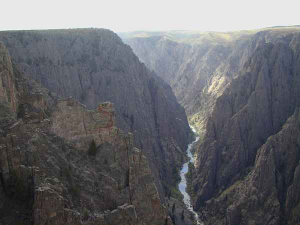
The Bureau of Reclamation began increasing releases from the Aspinall Unit, consisting of Blue Mesa, Morrow Point, and Crystal reservoirs on the Gunnison River, on May 14, 2017. The increased release will attempt to meet flow targets on the Gunnison River, designed to benefit endangered fish species downstream while continuing to meet the congressionally authorized purposes of the Aspinall Unit.
Flows in the Gunnison River through the Black Canyon will increase at a minimum of 500 cubic-feet-per-second a day resulting in flows through the canyon that may reach 12,000 cfs by approximately May 23. Flows will remain around 11,500 cfs to 12,000 cfs for 3-5 days before incrementally decreasing toward a range of 5,000 cfs to 5,500 cfs around May 29.
The orange plume flows through the Animas across the Colorado/New Mexico state line the afternoon of Aug. 7, 2015. (Photo by Melissa May, San Juan Soil and Conservation District)
Here’s the release from the New Mexico Environment Department (Allison Scott Majure):
New Mexico’s Gold King Mine Spill Citizens’ Advisory Committee (CAC), based out of San Juan County, New Mexico, meets Monday, May 22, 2017 at 5:30 p.m. in the San Juan College Student Center‐ SUNS Room (accessible through the Henderson Fine Arts Center) in Farmington.
The Citizens’ Advisory Committee (CAC) is a group of 9 citizen volunteers from Northern New Mexico, including the Navajo Nation, who provide a forum for public concerns while tracking the scientific long‐term monitoring of the Gold King Mine spill’s effects in the state. At Monday’s meeting the group will hear and discuss updates from the Navajo Nation and from the U.S. EPA Region 8 as follows:
Presentation by Dr. Karletta Chief, University of Arizona, discussing the impact of the Gold King Mine Spill on the Animas River on the Navajo Nation, and
Presentation by Rebecca Thomas, EPA Superfund Project Manager-Region 8, providing an update on the Bonita Peak Mining District Superfund Project.
The meeting agenda can be found at: https://www.env.nm.gov/wp-content/uploads/2016/06/May-2017-Agenda.pdf. The CAC works with New Mexico’s Long‐Term Impact Review Team, established by Governor Susana Martinez, to both monitor and discuss with the public the continuing effects of the August 2015 mine blowout, that the U.S. Environmental Protection Agency admitted to causing which released over three million gallons of mining wastewater laden with more than a million pounds of metals into the Animas and San Juan River systems.
Site of Chimney Hollow Reservoir via Northern Water.
Map from Northern Water via the Fort Collins Coloradan.
Chimney Hollow Reservoir site via the Bureau of Reclamation
Site of proposed Chimney Hollow Reservoir — Windy Gap Firming Project via the Longmont Times-Call
Windy Gap participants (2012)
Windy Gap Reservoir
Windy Gap Reservoir
Here’s the release from the US Army Corps of Engineers Omaha District (Kiel Downing/Cheryl Moore):
The Corps of Engineers, Omaha District, finalized its Record of Decision (ROD) approving the Windy Gap Firming Project on May 17, 2017. The project is proposed by the Municipal Subdistrict, Northern Colorado Water Conservancy District (Subdistrict) and involves the construction of Windy Gap Firming Project Water Supply facilities for its customers and 13 other Front Range water providers. The Subdistrict requested a Section 404 Clean Water Act (CWA) Permit from the Corps’ Omaha District Denver Regulatory Branch. “Due to the potential for significant environmental impacts to the East and West Slopes of Colorado, this project resulted in the preparation of an Environmental Impact Statement (EIS)” said Kiel Downing, Denver Regulatory Office Chief. The U.S. Bureau of Reclamation (Reclamation) was the lead federal agency preparing the EIS, and the Corps participated as a Cooperating Agency.
The original Windy Gap Project, constructed in the early 1980’s, was intended to provide more than 40,000 acre-feet of firm yield to the east slope, but due to operational constraints that didn’t happen. The project currently captures water from the Colorado River, pumps it to existing reservoirs on the west slope and moves the water through a tunnel system (the Colorado-Big Thompson Project operated by Reclamation) to the Front Range of Colorado. Because of the historic deficiency in water deliveries and lack of storage, the Windy Gap Project participants have not been able to fully rely on existing Windy Gap Project water for meeting a portion of their annual water demand. As a result, the participants, initiated the proposed construction of the Chimney Hollow Reservoir, which would firm all or a portion of their individual Windy Gap Project water allotment units to meet a portion of existing and future municipal and industrial water requirements. The Chimney Hollow Reservoir, as proposed, is a 90,000 AF capacity reservoir that will be dammed at the northern and southern limits.
Reclamation published the Windy Gap Firming Project, Environmental Impact Statement in November of 2011, and ROD on December 12, 2014. The State CWA Section 401 Water Quality Certification began shortly thereafter with the Subdistrict submitting its application to the State in March of 2015. The State issued the Section 401 WQC for the WGFP on March 25, 2016. This determination was necessary for the Corps determination under Section 404 of the CWA. The Subdistrict provided the Corps its Mitigation Plan for permanent and temporary impacts to Waters of the U.S. associated with the WGFP on March 17, 2017 and the Corps with continued agency collaboration, updated study information, and new Federal and State requirements, finalized their ROD shortly thereafter marking the end of the federal approval process.
Kiel Downing, Denver regulatory office chief for the Corps of Engineers, announced Wednesday afternoon the Record of Decision for the Clean Water Act permit for the Windy Gap Firming Project, which includes the reservoir.
With the final federal permit in hand, Northern Water officials can start planning for construction of the $400 million project, which is set to start in late 2018 or early 2019, according to Northern Water Public Information Officer Brian Werner.
“We’re smiling,” Werner said. “These things come along once in a generation.”
Berthoud-based Northern Water will manage the construction of a pair of dams in a valley west of Carter Lake that will hold approximately 90,000 acre-feet of water, or about 29 billion gallons — enough water for more than 90,000 households.
Water to fill Chimney Hollow will come from the Colorado River basin in years when its flows are above average. The water will be carried through a diversion at Windy Gap Reservoir in Grand County to Lake Granby and the Colorado-Big Thompson Project.
Municipalities including Loveland, Fort Collins and Greeley conceived of Windy Gap in 1970. The need for storage space for the communities involved to “firm” their ownership of the Windy Gap water rights expanded in later years to include Chimney Hollow Reservoir because in above-average precipitation years, Lake Granby often does not have enough space to store the additional water.
Rep. Hugh McKean, R-Loveland, said he was ecstatic when he heard about the Corps of Engineers’ approval, comparing it to Christmas.
In his time serving on the Loveland City Council and then the Colorado House of Representatives, he has seen how much the storage project was needed…
For cities such as Loveland, Windy Gap water fills an important role for its municipal users because it is a 365-day-a-year, deliverable water source, unlike in-basin seasonal water offered through local ditch companies. It will join the Colorado-Big Thompson Project shares in the city’s water portfolio…
McKean acknowledges that because the water has not been diverted before, questions and concerns will emerge from Western Slope water users and communities. However, because the Windy Gap Firming Project water is available only in years of above-average flows on the Colorado River, municipalities on the Front Range won’t be served until water rights holders on the Western Slope get their allocations.
He said he will be in Montrose this summer at a meeting of the Uncompahgre Water Users Association to talk about the project’s effect on the basins and in the context of the state water plan.
From the Associated Press (Dan Elliott) via The Colorado Springs Gazette:
The federal government gave final approval Wednesday for a $400 million dam and reservoir in northern Colorado where 13 cities and water districts will store water from the other side of the Continental Divide.
The Army Corps of Engineers issued a permit for construction of the Chimney Hollow Reservoir in the foothills about 50 miles (80 kilometers) north of Denver.
The corps regulates some of the environmental impacts of big water projects.
It is the last approval the reservoir needs, said Brian Werner, a spokesman for the Northern Colorado Water Conservancy District, which oversees the project.
Construction could start in early 2019, after the district refines the plans, hires a project manager and awards contracts.
Water for the reservoir would be pumped from the Windy Gap Reservoir on the Colorado River near the town of Granby, west of the Continental Divide, through an existing tunnel under the Rocky Mountains to the east side of the divide.
The 13 water providers own the rights to the water but have nowhere to store it. The project is formally called the Windy Gap Firming Project because it would firm up the water supply.
The Chimney Hollow Reservoir will store up to 90,000 acre-feet (1.1 million cubic meters). One acre-foot (1,200 cubic meters) can supply two typical households for a year.
New reservoirs are always contentious in Colorado. Water managers and urban planners argue the state needs more because it does not have the capacity to store all the water it is entitled to under agreements with other states. They also say Colorado needs more water for its growing population.
Some conservationists oppose new reservoirs because of their environmental damage and because the state’s rivers are already overtaxed.
“The Colorado River is on life support right now,” said Gary Wockner, director of Save the Colorado. “If the patient is bleeding out, you don’t cut open a new artery to try and heal it. Instead, you should work to protect and restore the river, not further drain it.”
Wockner said his group will likely challenge the Corps of Engineers permit in court.
Trout Unlimited negotiated some environmental improvements in the Colorado River near the Windy Gap Reservoir as part of the project. Mely Whiting, an attorney for the group, said she had not yet seen the final Corps of Engineers permit.
Water providers that will pay for and benefit from the Chimney Hollow Reservoir are the cities of Broomfield, Erie, Greeley, Longmont, Louisville, Loveland, Superior, Evans, Lafayette and Fort Lupton, as well as the Central Weld County and Little Thompson water districts.
Click here to go to the US Drought Monitor website. Here’s an excerpt:
Summary
An active weather pattern continued to result in widespread showers, with some of the heaviest rain falling across the Plains, Midwest, and mid-South. Another area of significant precipitation stretched across the middle and northern Atlantic States, while showers also dotted the Northwest. In contrast, mostly dry weather prevailed from California to the lower Rio Grande Valley, as well as large sections of the lower Southeast. Drought changes from last week were a mix of improvement and deterioration. Specifically, warm, dry weather and short-term rainfall deficits in Texas led to significant increases in the coverage of abnormal dryness (D0) and moderate to severe drought (D1 to D2). Also, hot, mostly dry conditions led to further expansion of moderate to extreme drought (D1 to D3) across southern Georgia and Florida’s peninsula. Elsewhere, patchy improvements in the drought situation were noted in a few areas, including parts of the Southeast…
High Plains
Wet weather continued across southern sections of the High Plains region and moved into northern areas as the monitoring period ended on May 16. (Rain that fell after 7 am CDT on May 16 will be reflected on next week’s map.) In north-central Colorado, coverage of moderate drought (D1) was greatly reduced by recent and ongoing wetness. Farther north, there was some modest expansion of dryness (D0), mainly in North Dakota, although conditions were highly favorable for fieldwork. During the week ending May 14, nearly half (45%) of the corn acreage was planted in South Dakota, along with 35% in North Dakota. However, South Dakota also led the northern U.S. in topsoil moisture rated very short to short (40% on May 14), as well as rangeland and pastures rated very poor to poor (20%)…
West
With little drought coverage in the West, changes were minimal. Specifically, short-term precipitation deficits led to expanded coverage of abnormal dryness (D0) in eastern Utah and western Colorado. The dry weather, accompanied by periods of warmth, has led to an earlier-than-normal loss of snow in several river basins. Meanwhile, severe drought (D2) was added to the remainder of southern Arizona, as drought impacts and precipitation deficits at various time scales in the former moderate drought (D1) areas were not appreciably different than those in the D2 region. Farther east, New Mexico’s topsoil moisture was rated 58% very short to short on May 14, according to the U.S. Department of Agriculture…
Looking Ahead
An extremely active weather pattern, featuring heavy rain, severe thunderstorms, and local flooding across the nation’s mid-section, will continue for the next few days. During the weekend, rainfall intensity will gradually diminish as showers shift into the eastern U.S. Five-day rainfall totals could reach 2 to 5 inches from the southern Plains into the upper Midwest, with 1 to 3 inches possible as far east as the Appalachians. Little or no rain will fall, however, along the Atlantic Seaboard. Significant precipitation, including high-elevation snow, will continue into Thursday across the Rockies and environs, but dry weather will prevail from southern California into the Desert Southwest. A period of very cool weather will trail the storminess, but warmth will return to the Pacific Coast by Friday and expand eastward during the weekend.
The NWS 6- to 10-day outlook for May 23 – 27 calls for the likelihood of below-normal temperatures from the Plains to the western slopes of the Appalachians, while warmer-than-normal weather can be expected west of the Rockies and along the southern Atlantic Coast. Meanwhile, below-normal precipitation from the Pacific Northwest into the upper Midwest should contrast with wetter-than-normal weather across the southern and eastern U.S.
FromThe Vail Daily (Scott N. Miller) via Steamboat Today:
Streamflows have risen quickly this season, thanks to warm weather, and may be close to seasonal peaks, depending on where you are.
As of Monday, the Colorado River between the Pumphouse campground and State Bridge was running at 2,200 cubic feet per second, the lower range of “runnable,” according to http://americanwhitewater.org.
Several miles downstream, the Colorado River between the Hanging Lake exit off Interstate 70 and the Shoshone Power Plant was running at 5,070 cubic feet per second.
Both of those streamflow readings were declines from the previous day’s reading.
Monday flows on the Eagle River had also declined from the previous day’s reading, with the stretch between Edwards and Eagle running at 1,560 cubic feet per second, the lower range of runnable for rafts.
Slower flows
Those streamflows should decline even more this week, given the weather forecast. According to the National Weather Service’s forecast for Avon, daytime temperatures were forecast to drop into the mid-40s from Wednesday through Friday. Those lower temperatures are expected to be accompanied by a solid chance of rain or snow.
The good news from the temperature drop is that snowpack will linger on the hillsides a bit longer.
The better news is that delayed runoff also lessens the chance of flooding.
Eagle County Emergency Management Director Barry Smith said at the moment, there’s no real flood danger in the county.
Smith said he watches overnight low temperatures from Leadville as a kind of guide to whether high-elevation snowpack is about to start melting in earnest. If overnight lows in the higher elevation stay below freezing — 32 degrees — then the snowpack will mostly stay in place.
So far, those overnight lows have stayed cold.
Even with an average snow year — or below-average in some locations — Smith said flooding worries can still arise with a warm spring.
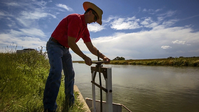
From the Rio Grande Basin Roundtable (Helen Smith) via The Valley Courier:
Water is the glue that holds the San Luis Valley together. It is vital to the people, the economy, lifestyle and even the physical landscape of the Valley itself.
There are two aquifers that lie beneath the Valley floor. One is the confined aquifer that is trapped below a series of clay lenses deep beneath the Valley floor. The other is the unconfined aquifer that is generally found within the first 100 feet of the surface. Without the water from these aquifers, the San Luis Valley would very likely not be the agricultural workhorse that we know today.
There are also unique geological structures such as Rio Grande Rift that contributes to when and where water travels throughout the Valley subsurface. Aquifers are key, particularly the unconfined. The water of the unconfined aquifer functions very much like surface water. The recharge of this important commodity comes from the mountains and the snow that brings down their runoff. The unconfined aquifer supplies 85 percent of agricultural well water. The largest concentration of these wells lies within Sub-district #1.
The confined aquifer lies beneath the unconfined aquifer. There are clay layers that separate the aquifers. Historic Alamosa Lake is likely responsible for the formation of these layers. The water that lies beneath the surface is heavily relied upon by the agricultural community. There are also differences in how each of the aquifers react. In addition, any well in the San Luis Valley inevitably impacts the river flow at some point.
As a Valley native from Saguache, Allen Davey of Davis Engineering Services has studied the San Luis Valley aquifer system extensively. He also has a great deal of background on the Valley’s water issues. Davey points out that the aquifers and well levels have been monitored since 1970, when accurate measurements were first available. Since that time, there have been notable trends in the increase and decrease of the aquifer and well levels. The water table itself has seen a significant and steady decline partly due to the sheer number of wells that have been drilled. More water has been taken than replaced. The worst decrease was the extreme drought that began in 2002. Historically speaking, demand has simply outweighed supply. Because of these factors, there are now big implications for the future.
Davey also explained that the aquifers are situated very much like a bowl of water. This means that there is pressure that pushes the water upward from beneath the clay and downward pressure from the surface. The result is wells in the confined aquifer have high amounts of pressure, the result of which is artesian flow. Both confined and unconfined wells are heavily relied upon especially for agriculture irrigation. This has resulted in a widening gap between the aquifer waters and the surface.
Because this gap between the water and the surface has increased, it is now not impossible that there is potential for the Valley floor to begin sinking if the aquifer is not replenished. Rebuilding the aquifer system has now become even more necessary than many once thought. It has now become imperative that this issue be addressed. It is also critical that the recharge process is working properly.
The effort to replace the depletions and rebuild the aquifer is another piece to this puzzle. This is where sub-districts, the Rio Grande Water Conservation District and the pending well rules and regulations for Division 3 come in. The pending regulations for Division 3 require well users to replace their depletions. There is also a slow gain in the northern portions of the aquifer system being seen though studies and reports that Davis Engineering Services provides to the Rio Grande Water Conservation District. Because the well owners of Sub-district #1 have been replacing their depletions, Davey believes that the aquifer is headed in the right direction because of monitoring and reduced pumping. Replacing depletions will only help agriculture as well as Colorado’s obligation to the Rio Grande Compact.
The well rules for Division 3 and the replacement efforts are still a work in progress. However, it would appear that these measures are producing some results. The trial to finalize the rules for Division 3 is set for January of 2018. If and when these rules are approved, a great deal of change will arrive. Arguably, it is necessary change.
The future remains to be seen. There is certainly a great deal of importance in this matter when considering the agriculture, the people and the future of the San Luis Valley. This is a unique situation that will require a unique solution.
Helen Smith is the Outreach Specialist for the Rio Grande Basin Roundtable.
The Rio Grande Basin Roundtable meets the second Tuesday of every month. Meetings are located at the San Luis Valley Water Conservancy District office at 623 4th St. Alamosa. For more information visit http://www.RGBRT.org.
Bicycling the Colorado National Monument, Grand Valley in the distance via Colorado.com
FromThe Grand Junction Daily Sentinel (Gary Harmon):
Mesa County District Judge Lance Timbreza on Wednesday rejected motions from both sides for summary judgment in the case, meaning that a trial set to begin June 5 will go forward.
The drainage district in 2016 began charging the fee — $36 per year for most residences — within its 90-square-mile district on the north side of the Colorado River.
Businesses are charged $36 a year for each 2,500 square feet of impervious surfaces, generally roofs and parking lots.
The Mesa County Commission and Grand Junction Area Chamber of Commerce filed suit alleging that the charge amounted to an illegal tax under the state Constitution.
The district has collected more than $3 million so far from the bills it sent out last year and this one.
The undisputed facts offered by both sides do not resolve whether the district’s charge is a fee or a tax, Timbreza wrote, noting that he was aware that his predecessor said the charge was “in the nature of a fee.”
Judge David Bottger made that finding in denying a request by the county and chamber for a preliminary injunction halting collection of the fee.
Bottger’s finding, however, “does not carry any precedential value in this case or in any other case,” Timbreza wrote.
One issue Timbreza said he wants resolved is the primary purpose of the charge.
The district needs to raise revenue to improve its ability to handle “regulated water,” or water that is unrelated to the district’s original purpose, that makes its way into the district’s system of pipes, conduits and ditches.
“I cannot determine whether the primary purpose of the revenue generated by the fee is to improve all facilities for the benefit of all of the district’s services or only for the specific purposes of regulating regulated water, which includes stormwater, and the regulation, handling and control of stormwater is a primary, legislative purpose of the district,” Timbreza wrote.
Representatives of both sides said they welcomed the trial.
“I think both sides would agree, we need a good, serious judicial look, so we all know where we stand,” Mesa County Commissioner Scott McInnis said.
Better to determine the status of the charge now instead of 10 years from now, said Tim Ryan, general manager of the drainage district.
“The whole process is a welcome development for the district,” Ryan said.
Ryan and McInnis both are to testify in the case.
“We look forward to the opportunity to present our case in court that this is indeed a tax on residents in the Grand Valley Drainage District,” said Diane Schwenke, president and chief executive officer of the chamber.
Click here to read the current assessment. Click here to go to the NIDIS website hosted by the Colorado Climate Center.Upper Colorado River Basin month to date precipitation through May 15, 2017 via the Colorado Climate Center.
Forest ecosystems around the world are under the gun from climate change, development, insect invasions and conversion to agriculture. This stand of lodgepoles in Colorado was clear cut after pine beetles killed most of the trees.
Here’s the release from the Colorado State University (Jim Beers):
The CSU Water Center has selected four multi-disciplinary teams and three individual faculty members as recipients of competitive grants totaling $129,553 for 2017-18.
The seven projects involve 25 faculty members and eight students from across campus. True to the mission of the Water Center, these projects involve water research, teaching, and engagement through interdisciplinary collaboration and creative scholarship among faculty and students.
Among the topics research teams will explore include:
Metal impacts on stream ecosystems.
Quantifying the impact of permanently drying up agricultural land due to rural to urban water transfers.
Individual faculty members will examine:
Factors that drive residential and commercial water demand.
Fish conversation methods in extreme habitats.
Reducing forest fuels, protecting water supplies
Tony Cheng, professor in the Department of Forest and Rangeland Stewardship in the Warner College of Natural Resources, is leading a nine-person team that will research the effect of reducing forest fuels on wildfire severity and post-fire erosion.
“Drought and warming temperatures are increasing the risk of large, severe forest wildfires in Colorado and throughout the western U.S., prompting forest land managers and water providers to invest millions of dollars to reduce flammable fuel loads to protect water supplies,” said Cheng. “Our research team has been developing new methods to quantify the effectiveness of these forest management activities, with the intent of providing investors with metrics indicating return on their investments. The Water Center’s Water Research Team award will allow us to extend the reach and impact of our research to address this important issue.”
Removing pharmaceuticals, personal care product chemicals
Susan De Long, assistant professor in the Department of Civil and Environmental Engineering in the Walter Scott, Jr. College of Engineering, heads up a four-member group working to remove certain contaminants from water supplies.
“Pharmaceutical and personal care product chemicals are now routinely being detected in lakes, rivers and even drinking water, because conventional wastewater treatment plants do not effectively remove these chemicals from our water,” De Long said. “Some of these chemicals have also been found in foods that were irrigated with water containing very low levels of these contaminants. Our research is focused on developing low cost, environmentally sustainable technologies to remove these contaminants from our waters using naturally occurring, safe types of bacteria. The Water Center funding is allowing us to advance our understanding of which bacteria are most useful using next-generation gene sequencing technologies.”
‘Green’ water planning
Kelly Curl, associate professor in the Department of Horticulture and Landscape Architecture in the College of Agricultural Sciences, is one of three water faculty fellows. Curl’s research focuses on integrating green infrastructure within land-use and water planning.
“As our population continues to increase, it will become ever more critical that the inclusion of successful green infrastructure becomes integrated within land-use planning and water planning,” said Curl. “We must look to the regional scale for the success of water efficient landscapes within our built environment. I would like to thank the CSU Water Center for giving me the opportunity to initiate my research goals on this critical topic.”
Faculty across campus
The CSU Water Center brings together more than 200 faculty members from various colleges and departments to promote water-related research to students, staff and community members.
The Water Center helps to foster CSU’s capacity to address various water-related topics while advancing the university as a center of water excellence and a leader in water scholarship. Through its organizational efforts, the Water Center brings together water faculty, staff, and students who are better equipped to work toward improving water in Colorado, the U.S., and internationally.
CSU Water Center has funded 26 interdisciplinary research teams, 10 faculty fellows, and one symposium planning team since 2014, totaling more than $675,000. These projects have resulted in more than $11 million in external funding. The Water Center’s call for proposals is released in January of each year and is open to all CSU faculty and research scientists.
Colorado River Trail near Fruita September 2014 FromThe Grand Junction Daily Sentinel (Gary Harmon):
The Colorado River is a still largely unrecognized asset that could flood the Grand Valley with economic opportunities, speakers said at a State of the River conference Monday.
“We’re not maximizing use of the river from a commercial perspective,” Sam Williams, general manager of Powderhorn Mountain Resort, told about 50 people at the conference at the Avalon Theatre in downtown Grand Junction.
Williams spoke on a panel with Palisade-area fruitgrower Bruce Talbott, Grand Junction Economic Partnership Executive Director Kristi Pollard, Alpine Bank Senior Vice President David Miller and Sarah Shrader, owner of Bonsai Design in Grand Junction and a founder of the Outdoor Recreation Coalition.
“We sell lifestyle” when trying to attract businesses to the Grand Valley, and a large part of that is the presence of “this amazing asset we have,” the Colorado River, Pollard said.
Shrader, whose company is developing an outdoor-recreation business park along the river, noted that other cities that have taken advantage of the river through town to use as an attraction have seen a turnaround in the business climate to one of optimism and activity.
“This community is poised to do something really fantastic,” Shrader said.
Involving businesses and people in the river can aid with the recovery of the four endangered fish species in the Colorado River Basin, as well as others, such as the Western yellow-billed cuckoo, by encouraging an ethic of stewardship, Shrader said.
All of Alpine Bank’s branches sit on or near the banks of the Colorado or one of its many tributaries, Miller said.
That has served as a reminder that the health of the river is directly tied to the health of the businesses along it, Miller said.
Alpine Bank has moved to reduce its water use by 40 percent and has saved $12,000 annually in doing so, he noted.
Agriculture in the east end of the Grand Valley — peaches and grapes specifically — has served to make his family business “the darling of the valley,” Talbott said.
It’s been successful on the financial score, as the 2,500 acres of fruit lands generate some $60 million in ultimate retail sales, Talbott noted.
Nonetheless, it’s clear that fruitgrowers and others are well served to look out for their water supplies because, “We farm at the consent of the public,” Talbott said.
“We have to grow (crops) as inexpensively as possible” while looking to assure long-term water supplies, Talbott said.
The meeting was sponsored by The Colorado River Water Conservation District, the Ruth Powell Hutchins Water Center at Colorado Mesa University and the Business for Water Stewardship. Alpine Bank, the Tamarisk Coalition and Club 20 also supported the conference.
There were many speakers at the ‘State of the River’ event, taking a critical look at the resource flowing through the valley. They explained the challenges the water supply faces…
Experts are concerned because they believe the river is operating at a long-term deficit, meaning more water is used than the amount we gain from rain or snow.
“Water is really important in Colorado because we are an arid state,” said Aaron Clay, a Delta water law attorney. “It takes water to make any economy run, whether it’s agriculture, manufacturing or municipal.”
“So between people and industry asking more of the river system — and this is all states states on the river — and warming temperatures, that has put a burden on supply,” said Jim Pokrandt, the community affairs director of the Colorado River District.
Gigi Richard, faculty director of the CMU’s Water Center, said the only source of water is precipitation. With a third of the Colorado River Basin getting fewer than 10 inches of rain each year on average, the Colorado River relies on melted snow pack.
“In a sense we’re snow farmers,” Pokrandt said. “While some people may paying attention to commodity prices, our commodity is snow pack.”
Richard said more than 80 percent of Mesa County’s water is used for agricultural irrigation.
Though it’s valuable for family homes to conserve water as much as possible, Clay said that doesn’t put a dent in it.
The presentation is this evening. I hope to see you there.
I need your help getting word out about my presentation, “Climate Change is Water Change: Colorado Update,” May 16th, 6:00 – 7:30 PM, Thornton Community Building, 2211 Eppinger Blvd.
Please click on this Facebook link and Like it or Share it with your network.
Please be sure to bring your children along. Mitigating the effects of the climate crisis is really for them. It is an existential threat for many species along with being the social justice movement of our time.
I will address three questions:
Should we act to mitigate climate change?
Can we and how can we mitigate climate change?
Will we act to mitigate climate change and what can we do?
The Colorado River and other crucial sources of water in the West are declining, thanks to climate change. brewbooks/CC Flickr
Here’s a report from Emily Benson writing for The High Country News. Click through and read the whole article. Here’s an excerpt:
Picture a snowflake drifting down from a frigid February sky in western Colorado and settling high in the Rocky Mountains. By mid-April, the alpine snowpack is likely at its peak. Warming temperatures in May or June will then melt the snow, sending droplets rushing down a mountain stream or seeping into the soil to replenish an aquifer.
The West’s water supply depends on each of these interconnected sources: the frozen reservoir of snow atop mountain peaks, mighty rivers like the Colorado and groundwater reserves deep below the earth’s surface. But the snowpack is becoming less reliable, one of the region’s most important rivers is diminishing and in many places the groundwater level has dropped. Three recent studies illuminate the magnitude of these declines, the role climate change has played and the outlook for the future.
All three studies point to the influence of a warming climate. “Climate change is real, it’s here now, it’s serious and it’s impacting our water supplies in a way that will affect all of us,” says Bradley Udall, a water and climate researcher at Colorado State University. The situation is dire, he says, but reining in greenhouse gas emissions now could help keep the mountains covered with snow and the rivers and aquifers wet.
FromThe Glenwood Springs Post Independent (Alex Zorn):
The State of the River featured several presentations. Speakers included Scot Dodero, who discussed the Silt Water Conservancy District and its upcoming $3 million upgrade to its pump house, and Eric Kuhn, general manager of the Colorado River District, who focused on big picture questions facing the Colorado River.
The Colorado River District started these meetings 24 years ago. Kuhn sees exports as a potential issue in the future, for every drop of water is used from the river.
“If California is in a drought and they can’t export more water from northern California, they will take more from the Colorado,” he explained.
He compared it to a rubber band being pulled on both sides; eventually it is going to snap.
Kuhn listed demand management and cloud seeding (or snowmaking) as potential solutions in contingency planning, but admitted it was a complex issue.
The evening’s final presentation looked at the Grand Valley water banking experiment, which will test how conserving consumptive water use by agricultural fallowing will send more water to Lake Powell to help bolster low reservoir levels.
“Water banking is the practice of intentionally foregoing diversion or consumptive use of a water resource and banking the conversed volume for use at a future date or different purpose,” said Mark Harris of the Grand Valley Water Users Association.
In 2017, 10 farm operators across the valley, each committing a minimum of 60 acres, will participate in the pilot program to reduce water consumption. The program will ensure that agricultural water users would have a seat at the table if and when water rights becomes more of an issue. In turn, they won’t be expected to shoulder the burden in drought conditions.
Abby Burk, Western Rivers Pro- gram lead for Audubon Rockies, will be the featured speaker at the Weminuche Audubon Society’s meeting on Wednesday, May 17.
Burk brings extensive ecological land management experience to her work with state and federal agencies, conservation organizations, businesses and community leaders. She is committed to advancing riparian habitat and stream resiliency through environmental river flow awareness and advocacy.
She will review Audubon’s work for western rivers and will address the goals and the implementation of crucial aspects of the Colorado water plan.
The meeting will be held at the Community United Methodist Church at 434 Lewis St. Refresh- ments and socializing begin at 6 p.m. Burk’s presentation will be- gin shortly afterwards. Everyone is welcome to attend what will be an interesting and rewarding evening.
Meeting this demand with fossil fuels will be increasing dif cult as reserves become depleted. More important, we know that massive burning of fossil fuels damages our environment. Renewable energy sources, such as solar and wind, provide an inexpensive and clean alternative to burning fossil fuels.
To prepare the next generation for this change, Kristin Hentschel, Pagosa Springs Middle School sixth-grade science teacher, orga- nized a Renewable Energy Day.
This project was funded by a $1,000 grant from the Foundation for Archuleta County Education (FACE).
The 120 sixth-grade students were divided into eight groups which visited eight renewable energy projects. Parents and com- munity scientists manned each of the eight stations.
At the end of the day, the stu- dents wrote about their experiences…
“I liked all the stations. This was perfect.” — Daniel B.
During the board’s regular May meeting Wednesday night the Board of Trustees discussed rate hikes of $10 a month in September and another $7.50 a month in January 2018, with an increase of $2.50 a month in water rates to accompany the January sewer hike.
Mayor Amy Sorensen said she’d negotiated two loans with the U.S. Department of Agriculture totaling $414,000 to pay for new lined sewer lagoons and related structures. Iliff residents now pay $38.75 a month for water service and $26.28 for sewer for a total of $65.03. In September, under Sorensen’s plan, that would go up to $75.03 and then rise to $85.03 in January 2017 to pay off those loans.
Iliff last raised its water rates in 2015.
The town is not alone in facing skyrocketing utility rates. Fleming could be forced to virtually double their sewer rates if they end up having to build new sewer ponds; Merino already has raised water rates to pay for its new reverse osmosis water system and is looking at significantly higher sewer rates; and Peetz has been told to brace for giant leaps in rates if they, too, have to build new wastewater evaporation ponds.
Trustees were not happy with the numbers Sorensen handed them but didn’t blame the new mayor; a survey of towns the size of Iliff in Colorado shows steadily increasing sewer and water rates across the board, and Iliff is still below the average.
The SPMP is a year-long study of flood mitigation on the lower South Platte River. Authorized and funded by the Colorado Department of Local Affairs, the plan will try to find ways to make the river more “flood resilient,” both to handle the flooding as it occurs, with minimal damage to property and structures, and to quickly recover from a flood in the aftermath.
The project area includes 130 miles of the South Platte River from the Weld-Morgan County Line to the Nebraska state line.
Friday’s meeting was organized primarily by Logan County Commissioner Dave Donaldson and hosted by Morgan County Commissioner Jim Zwetzig, but was attended by commissioners from all four counties and a variety of other water interests.
Donaldson opened the meeting by saying, as he has in the past, that he would like to see some “channelizing” of the South Platte in areas where sand bars and other sediment accumulations have caused some blockage to the river, which worsens flood damage.
Kayla Uptmor, chief of civil works for the U.S. Army Corps of Engineers Omaha District, said any COE work done on flood mitigation would have to have a return on investment.
“Our first question is, ‘What is the need for federal investment,'” Uptmor said. “The thinking in Congress is that for projects like this, there needs to be a dollar-for-dollar return to the federal government on the investment made.”
She said that doesn’t necessarily mean revenue; in the case of flood mitigation the return would be in terms of less damage.
In any event, Uptmor said, it would be at least 2020 before any funds could even be budgeted for DOE projects on the South Platte River.
Kevin Houck, chief of watershed and flood protection for the Colorado Water Conservation Board, said several times during the meeting that once the study is finished, early next year, would require a “coalition of stakeholders,” and solutions would have to be driven from the local communities, not from the state.
“Any solutions that are identified would have to involve the irrigation communities because they are a key component of what you accomplish in the river,” he said. “Ultimately, we would like to see solutions focused on the four counties (covered by the study.)”
Joe Frank, manager of the Lower South Platte Water Conservancy District, which includes the same four counties as the SPMP study, again stressed the need to coordinate the SPMP with the results of a CWCB-funded study of storage possibilities on the South Platte River.
“I think that has to be an important part of it, how do we tie flood mitigation to storage,” he said.
Morgan County Commissioner Jim Zwetzig asked how the panel thought the necessary coalition might form. Brian Murphy, project director for CDM Smith of Denver, the contractor on the flood study, said the stakeholder coalition for what is called the Middle South Platte Master Plan, done on a 20-mile stretch of the South Platte from St. Vrain Creek to the confluence with the Big Thompson River, didn’t begin to form until the late stages of the study.
After the meeting Zwetzig said he thought the lower South Platte coalition would look “much different from the Middle South Platte coalition.”
“That one was 20 miles and there was a lot of municipal stuff in it, it was a lot more urban,” he said. “We’re looking at 130 miles of river with 32 (irrigation) diversions, so there will be much more of an agricultural component. Also, (Colorado Department of Transportation) and the Parks and Wildlife people will be a lot more involved.”
Donaldson said he thought the three-hour meeting had been productive and had shown stakeholders that there are information resources that can be drawn on.
Twenty plastic barrels once used to ship Mountain Dew syrup were reborn on Saturday into water conservation tools for local gardeners.
The barrels, purchased from a recycled materials provider in Denver, were distributed at a “make and take” rain barrel event hosted by El Paso County’s Colorado State University Extension. The $60 class, the second that the local CSU Extension office has held since the state legalized the use of rain barrels last year, quickly filled up. Two more classes, already full, have been scheduled for the coming weeks.
Organizers said it’s a sign of residents’ growing curiosity about rain barrel use, which Colorado was one of the last states to allow. Under a law passed in May 2016, single-family homes are permitted two rain barrels with a combined storage capacity of up to 110 gallons. Rainwater can only be collected from rooftop downspouts and must be used on the same property where it was collected for outdoor purposes, such as watering lawns and gardens…
The CSU Extension estimates one rain barrel can save the average homeowner roughly 1,300 gallons of water during the hottest months of the summer, when landscape watering accounts for nearly 40 percent of all household water usage.
In addition to conserving water, collecting rainfall during downpours can help reduce the pressure on the city’s stormwater system, said Sean Holveck, who is in charge of marketing and events for The Greenway Fund of Colorado Springs.